use cases and initial user requirements - beaware-project.eu · d2.1 – v1.4 d2.1 – v1.0 page 3...
TRANSCRIPT
This project has received funding from the European Union’s Horizon 2020 research and innovation program under grant
agreement No 700475
beAWARE Enhancing decision support and management services in extreme weather
climate events
700475
D2.1
Use Cases and Initial User Requirements
Dissemination level: Public
Contractual date of delivery:
Month 5, 31 May 2017
Actual date of delivery: Month 5, 31 May 2017
Workpackage: WP2 Climate disaster management requirements
Task: T2.1 - Use Case Specification
Type: Report
Approval Status: Final Version
Version: 1.4
Number of pages: 148
Filename: D2.1_beAWARE_UseCasesAndInitialUserRequirements_2017-5-
31_v1.4
Abstract
This document describes the use cases and requirements of the beAWARE system, the methodology used to define the use cases and the risks, challenges and the impacts identified and analysed in order to define these use cases.
The information in this document reflects only the author’s views and the European Community is not liable for any use

This project has received funding from the European Union’s Horizon 2020 research and innovation program under grant
agreement No 700475
that may be made of the information contained therein. The information in this document is provided as is and no guarantee or warranty is given that the information is fit for any particular purpose. The user thereof uses the information at its sole risk and liability.
Co-funded by the European Union

D2.1 – V1.4 D2.1 – V1.0
Page 3
History
Version Date Reason Revised by
0.1 01.03.2017 Deliverable structure All partners
1.0 06.052017 Contribution by all the use case partners. Document for internal review during the Use Cases Meeting
All partners involved in T2.1 + IBM and MSIL
1.1 17.05.2017 Draft after the Use Cases Meeting CERTH, MSIL
1.2 22.05.2017 Added the Introduction and the Methodology sections and Review, comments and edits throughout. Draft for review
CERTH, MSIL, HRT, FMI
1.3 26.05.2017 Revised the deliverable according to reviewers
MSIL
1.4 31.05.2017 Final Version HRT, FMI, CERTH
Author list
Organisation Name Contact Information
AAWA Daniele Norbiato [email protected]
PLV Carmen Castro [email protected]
HRT Iosif Vourvachis [email protected]
FBBR Amalie Janniche [email protected]
FMI Ari Karppinen [email protected]
CERTH Anastasios Karakostas [email protected]
AAWA Michelle Ferri [email protected]

D2.1 – V1.4 D2.1 – V1.0
Page 4
Executive Summary
The deliverable reports on the initial set of user requirements for beAWARE, based on
profound analysis of operational scenarios for three different pilots: Vicenza (Italy-flood
emergency), Valencia (Spain- fire emergency) and Thessaloniki (Greece - heatwave
emergency).
This work was targeted to document the identified user needs for the respective user
requirements and it was performed to ensure consistency among different contexts.
In the first section it was demonstrated by literature how weather related emergencies, such
as floods, fires and heatwaves, are increasing in frequency and magnitude, consiquently
determining more and more critical impacts. During emergecy situation getting accurate
information about the scope, extent, and impact of the disaster is critical to creating and
orchestrating an effective disaster response and recovery effort. The goal of beAWARE is
therefore to propose an integrated solution to support forecasting, early warnings,
transmission and routing of the emergency data, aggregated analysis of multimodal data and
management the coordination between the first responders and the authorities.
In the second section the methodology, followed to define user requirements, is described.
In detail, the results of the activities performed are later reported for each pilot in terms of:
- risks, impacts and difficulties;
- operational scenarios and use cases;
- requirements.

D2.1 – V1.4 D2.1 – V1.0
Page 5
Abbreviations and Acronyms The following abbreviations have been used in this document:
AEMET State Meteorological Agency of Spain
AMICO Flood Forecasting System for the Bacchiglione River Basin
CCAA Comunidades Autónomas - Autonomous Communities / Regions
CCS Rescue Coordination Centres
CCE Control emergency coordination center
CECOM Firefighters Command Control Centre
CISE Command Control Centre
COC Municipal Operational Centres
COM Mixed Operational Centres
COR Regional Operations Centres
DICOMAC Command and Control Direction
DMI Danish Metrological Institute
DISTER Fire Detection by Thermal Sensors
IPT Integrated Product Team
KST Command Station
LBS Local Preparedness Staff
PEIF Special Plan against Forest Fire Risk
PMA Advanced Command Post
PSAP Public-safety answering point
UC Use Case
UR User Requirement
SCN Operational scenarios
SUEM Ready Health Intervention
D2.1 – V1.4 D2.1 – V1.0
Page 6
Table of Contents
TABLE OF CONTENTS ......................................................................................................... 6
LIST OF FIGURES................................................................................................................ 8
LIST OF TABLES ................................................................................................................. 9
1 INTRODUCTION ......................................................................................................... 10
1.1 Floods ........................................................................................................................ 11
1.2 Forest Fires ................................................................................................................ 13
1.3 Heat wave due to extreme temperatures .................................................................... 14
1.4 beAWARE Project goals .............................................................................................. 16
2 METHODOLOGY ........................................................................................................ 18
2.1 Conventions ............................................................................................................... 18
2.2 The Requirements Elicitation Process .......................................................................... 20
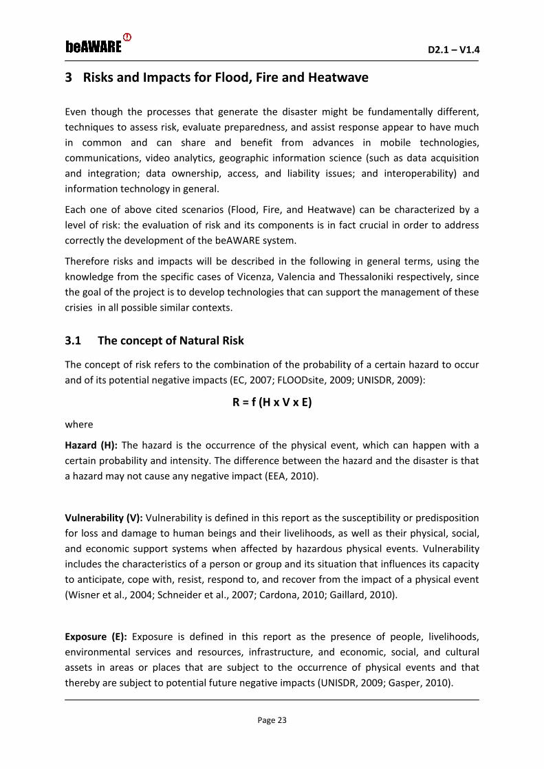
3 RISKS AND IMPACTS FOR FLOOD, FIRE AND HEATWAVE ............................................ 23
3.1 The concept of Natural Risk ........................................................................................ 23
3.2 Element at Risk .......................................................................................................... 25
3.3 Impacts ...................................................................................................................... 27
3.4 Difficulties .................................................................................................................. 35
4 OPERATIONAL SCENARIOS ........................................................................................ 41
4.1 SCN_1: Flood .............................................................................................................. 41
Description of Flood Demonstration site ..................................................................................... 41
Emergency protocol and communications ................................................................................... 45
Available resources ....................................................................................................................... 47
4.2 SCN_2: Forest Fire ...................................................................................................... 49
Description of the Valencia Demonstration site .......................................................................... 49
Emergency protocol and communications ................................................................................... 52
Available resources ....................................................................................................................... 56
Description of Forest fire measures in Tisvilde Hegn in Denmark ............................................... 56
4.3 SCN_3: Heatwave ....................................................................................................... 58
Description of Thessaloniki Demonstration site ........................................................................... 58
Emergency protocol and communications ................................................................................... 61
Available resources ....................................................................................................................... 62
5 BEAWARE USE CASES ................................................................................................ 63
5.1 Use Cases for the Flood scenario ................................................................................. 63
UC_101: Declaration of the attention status and continuos monitoring of flood forecasting .... 63
UC_102: Management of new flood emergencies ....................................................................... 65
UC_103: Monitoring river water level and assignment of tasks to first responders ................... 71
UC_104: Evaluation of the execution of tasks - ............................................................................ 75
UC_105: Monitoring rainfall ......................................................................................................... 79

D2.1 – V1.4 D2.1 – V1.0
Page 7
UC_106: Monitoring river breaking/overtopping and assignment of relative tasks .................... 84
UC_107: First responders monitoring .......................................................................................... 91
UC_108: Flood forecasting alerts ................................................................................................. 92
5.2 Use Cases for the Fire scenario ................................................................................... 93
UC_201: Management of forest fires emergencies ..................................................................... 93
UC_202: Activation of first responders ...................................................................................... 100
UC_203: Pre-emergency level 3 activation ................................................................................ 104
UC_204: Evacuation management during an emergency .......................................................... 107
5.3 Use Cases from Heatwave scenario ........................................................................... 114
UC_301: Heatwave forecasting alert .......................................................................................... 114
UC_302: Heatwave fire risk assessment ..................................................................................... 116
UC_303: First Responder Management ..................................................................................... 119
UC_304: Management of traffic emergencies ........................................................................... 121
UC_305: Management of Places for relief.................................................................................. 125
UC_306: Response to Power Outage.......................................................................................... 128
6 USER REQUIREMENTS .............................................................................................. 132
6.1 Requirements for Flood scenario use cases ............................................................... 132
6.2 Requirements for Fire scenario use cases .................................................................. 136
6.3 Requirements for heatwave scenario use cases ......................................................... 139
7 CONCLUSIONS .......................................................................................................... 145
8 REFERENCES ............................................................................................................. 146

D2.1 – V1.4 D2.1 – V1.0
Page 8
List of Figures Fig. 1-1. Trends in different types of natural catastrophe worldwide, 1980–2012 (1980 levels set at 100%; Munich Re NatCatSERVICE ). ................................................................................................................................. 10
Fig. 1-2. Relative trends of loss-relevant natural extreme events in different parts of the world (1980 levels set at 100%; data from Munich Re NatCatSERVICE). .................................................................................................. 11
Fig. 1-3. Projected average number of summer days exceeding the apparent temperature .............................. 15
Fig. 2-1: Requirement analysis scheme ................................................................................................................. 19
Fig. 2-2. The Requirements Elicitation Process ..................................................................................................... 21
Fig. 2-3. Requirement Development and Delivery Timeline ................................................................................. 22
Fig. 3-1. Graphical descriptions of risk (Kulturisk FP7 Project, 2011) ................................................................... 24
Fig. 3-2. Example of flood risk maps generation (Flood Risk Management Plan - AAWA, 2017) ......................... 25
Fig. 4-1. The Bacchiglione Catchment closed at Vicenza ...................................................................................... 41
Fig. 4-2. a) The 2010 flood event: a) Cumulative precipitation b) Bacchiglione River levels at Ponte degli Angeli Bridge in Vicenza ................................................................................................................................................... 42
Fig. 4-3. Levee breach upstream of Vicenza (a) and flooding of Vicenza City (b) during the 2010 flood ............. 42
Fig. 4-4. Flooded area in Vicenza after the 2010 flood compared with the 2012 (a) and the 2013 (b) floods ..... 43
Fig. 4-5. La Devesa de L'albufera ........................................................................................................................... 49
Fig. 4-6. La Devesa de L'albufera (Maps) ............................................................................................................... 50
Fig. 4-7. A typical fire that occured at La Devesa de L'albufera and precipitations´chart (monthly) .................... 50
Fig. 4-8. Forest fires chart per week in La Devesa ................................................................................................. 50
Fig. 4-9. Forest fires chart per month in La Devesa .............................................................................................. 51
Fig. 4-10. Forest fires chart per year in La Devesa ................................................................................................ 51
Fig. 4-11. Emergency protocols and communications .......................................................................................... 53
Fig. 4-12. Pre-established days with level 3 pre-emergency (2015) ..................................................................... 53
Fig. 4-13. Emergency action scheme ..................................................................................................................... 55
Fig. 4-14. Map of the forest Tisvilde Hegn. The bright green are cleared areas to help prevent and fight fires. . 57
Fig. 4-15. Example of drought index from DMI ..................................................................................................... 58
Fig. 4-16. Map of Thessaloniki............................................................................................................................... 59
Fig. 4-17. Projected frequency of days with apparent temperatures above 40.6 oC across Europe in 2100 ....... 60
Fig. 5-1. Block Diagram of the UC101.................................................................................................................... 63
Fig. 5-2. Block Diagram of the UC102.................................................................................................................... 65
Fig. 5-3. Block Diagram of the UC103.................................................................................................................... 71
Fig. 5-4. Block Diagram of the UC104.................................................................................................................... 76
Fig. 5-5. Block Diagram of the UC105.................................................................................................................... 80
Fig. 5-6. Block Diagram of the UC106.................................................................................................................... 85
Fig. 5-7. Block Diagram of the UC107.................................................................................................................... 91
Fig. 5-8. Block Diagram of the UC108.................................................................................................................... 92
Fig. 5-9. Block Diagram of the UC201.................................................................................................................... 93

D2.1 – V1.4 D2.1 – V1.0
Page 9
Fig. 5-10. PSAP visualization of resources and requirements at PLV .................................................................... 94
Fig. 5-11. Block Diagram of the UC202................................................................................................................ 100
Fig. 5-12. PSAP visualization of resources and requirements at PLV .................................................................. 101
Fig. 5-13. The Danish 112 application for mobile phone .................................................................................... 104
Fig. 5-14. Block Diagram of the UC203................................................................................................................ 104
Fig. 5-15. PSAP visualization of resources and requirements at PLV .................................................................. 105
Fig. 5-16. Block Diagram of the UC204................................................................................................................ 108
Fig. 5-17. PSAP visualization of resources and requirements at PLV .................................................................. 109
Fig. 5-18. Block Diagram of the UC301................................................................................................................ 114
Fig. 5-19. Heat Index Table .................................................................................................................................. 115
Fig. 5-20. Block Diagram of the UC302................................................................................................................ 117
Fig. 5-21. Danger levels for fire exposure ........................................................................................................... 118
Fig. 5-22. Block Diagram of the UC303................................................................................................................ 119
Fig. 5-23. Visual presentation of first responder status. ..................................................................................... 120
Fig. 5-24. Block Diagram of the UC304................................................................................................................ 122
Fig. 5-25. Visualization of real tiem traffic conditions in the city ........................................................................ 123
Fig. 5-26. Traffic jam in the Thessaloniki ring road ............................................................................................. 123
Fig. 5-27. Picture of traffic jam ............................................................................................................................ 124
Fig. 5-28. Block Diagram of the UC305................................................................................................................ 125
Fig. 5-29. Visualization of the status of places of relief in the city ...................................................................... 126
Fig. 5-30. Block Diagram of the UC306................................................................................................................ 128
Fig. 5-31. Visual presentation of people in distress ............................................................................................ 129
List of Tables Table 1-1. Floods in Europe with the highest (inflation-adjusted) losses ............................................................. 12
Table 1-2. Mortality attributed to hot summers or heatwave periods in Europe ................................................ 16
Table 3-1. Elements at Risk ................................................................................................................................... 26
Table 3-2. Impacts ................................................................................................................................................. 28
Table 3-3. Difficulties ............................................................................................................................................ 36
Table 4-1. The total damages in Veneto Region after the 2010 flood .................................................................. 44
Table 4-2. Damages to the City Center of Vicenza during the 2010 Flood Event ................................................. 44
Table 4-3.Pre-emergency levels ............................................................................................................................ 53
D2.1 – V1.4 D2.1 – V1.0
Page 10
1 Introduction
Climate conditions are expected to change worldwide. This includes an increase in intensity
and frequency of (among others) extreme weather events. Extreme weather-related events
may have great humanitarian impacts entailing loss of lives, in addition to the economic and
partly insured losses (EASAC, 2013). Data collected since 1980 by the insurance industry
provide one indicator of trends in extreme events. Although these are not direct measures
of extreme weather events per se and may not have recorded all perils in the earlier record,
they show weather-related catastrophes recorded worldwide to have increased from an
annual average of 335 events from 1980 to 1989, to 545 events in the 1990s and to 716
events for 2002–2011. Floods and the ‘climatological’ perils like heat waves, droughts and
wild fires show the most pronounced upward trend, followed by storms (Fig. 1-1). The
analysis presents a clear distinction between all weather-related perils and geophysical
hazard events like earthquakes, volcano eruptions and tsunamis, with the latter group
showing only a slight and statistically non-significant increase.
Fig. 1-1. Trends in different types of natural catastrophe worldwide, 1980–2012 (1980 levels set at 100%;
Munich Re NatCatSERVICE ).
Compared with other continents, the increase in loss-relevant natural extreme events in
Europe has been moderate (Fig. 1-2), with an increase of about 60% over the past three
decades. The highest increases have occurred in North America, Asia and Australia/Oceania
with today about 3.5 times as many events as at the beginning of the 1980s.

D2.1 – V1.4 D2.1 – V1.0
Page 11
Fig. 1-2. Relative trends of loss-relevant natural extreme events in different parts of the world (1980 levels
set at 100%; data from Munich Re NatCatSERVICE).
The economic loss burden of extreme weather events has been considerable, estimated to
be €405 billion since 1980 (in 2011 values). The most costly hazards have been storms and
floods, amounting to a combined total loss of more than €308 billion. The most affected
countries were Germany (455 events), France (425), United Kingdom (415), Switzerland
(360), Italy (355) and Spain (317). In agriculture, the 2003 and 2010 heat waves and
associated dry conditions resulted in major regional crop shortfalls. The drought conditions
and associated fires in the 2010 heat wave also caused a 25–30% drop in the forecast of
Russia’s annual grain crop production, compared with 2009.
As result of the above mentioned observations, flooding, heatwaves, fires, etc. will become
more common in the future leading to an increased need to better investigate them and
develop tools in order to mitigate their possible impacts.
1.1 Floods
There are many different types of floods. They can be distinguished based on the source of
flooding (e.g. rivers and lakes, urban storm water and combined sewage overflow, or sea
water), the mechanism of flooding (e.g. natural exceedance, defence or infrastructural
failure, or blockage) and other characteristics (e.g. flash flooding, snowmelt flood, or debris
flow). River floods are a common natural disaster in Europe, and — along with storms — the
most important natural hazard in Europe in terms of economic damage. They are mainly
caused by prolonged or heavy precipitation events or snowmelt. River floods can result in
huge economic losses due to damage to infrastructure, property and agricultural land, and

D2.1 – V1.4 D2.1 – V1.0
Page 12
indirect losses in or beyond the flooded areas, such as production losses caused by damaged
transport or energy infrastructure. They can also lead to loss of life, especially in the case of
flash floods, and displacement of people, and can have adverse effects on human health, the
environment and cultural heritage.
More than 325 major river floods have been reported for Europe since 1980, of which more
than 200 have been reported since 2000. The rise in the reported number of flood events
over recent decades results mainly from better reporting and from land-use changes. Global
warming is projected to intensify the hydrological cycle and increase the occurrence and
frequency of flood events in large parts of Europe. Flash floods and pluvial floods, which are
triggered by local intense precipitation events, are likely to become more frequent
throughout Europe (EEA Report, 2012).
Losses caused by floods in Europe have increased and the death toll continues to be high, as
illustrated in Table 1-1.
Table 1-1. Floods in Europe with the highest (inflation-adjusted) losses
Source: see Table 4.1 on page 61 of the full report (NAS and NMI, 2013), where the sources of information are
listed; additional data are from Dartmouth Flood Observatory.
The Floods Directive (EC, 2007) establishes a national and international framework for the
assessment and management of flood risks aimed at the reduction of the trans-national
adverse consequences for human health, the environment, cultural heritage and economic
activity. The Floods Directive also offers citizens, businesses and governments a clear overall
understanding of possible flood risks (vulnerable areas and potential damage), the
objectives and measures in place to reduce or control the risks and the order in which the
designated response teams will implement the measures.

D2.1 – V1.4 D2.1 – V1.0
Page 13
An overview of the concepts of floodrisk and uncertainty and flood terminology to be used
in the beAWARE project are reported in FLOODsite (2005).
1.2 Forest Fires
EU Forests and other wooded land cover 155 million ha and 21 million ha, respectively,
together more than 42 % of EU land area. The forests play a key role in protecting European
ecosystems and biodiversity, have a central role in trapping carbon which would otherwise
be released in the atmosphere and thus aggravating climate change..
Forest fires are an integral part of forest ecosystem dynamics in many ecosystems where
they are an essential element of forest renewal. They help control insect and disease
damage and eliminate litter that has accumulated on forest floors. At the same time, forest
fires are an important disturbance agent in many forested landscapes. Fire risk depends on
many factors such as weather, vegetation (e.g. fuel load and condition), topography, forest
management practices and socio‑economic context, to mention the main ones. Extreme fire
episodes and devastating fire seasons of recent years in Europe were in most cases driven by
severe fire weather conditions. Although most of the wild fires in Europe are ignited by
humans (either accidently or intentionally), it is widely recognised that weather conditions
and accumulation of fuel play a dominant role in affecting the changes in fire risk over time.
Thus climate change is expected to have a strong impact on forest fire regimes in Europe.
Fire risk depends on many factors, including climatic conditions, vegetation (e.g. fuel load
and condition), forest management practices and other socio‑ economic factors. The
number of fires in the Mediterranean region has increased over the period from 1980 to
2000; it has decreased thereafter. In a warmer climate, more severe fire weather and an
expansion of the fire-prone area and longer fire seasons, as a consequence, are projected,
but with considerable regional variation. The impact of fire events is particularly strong in
southern Europe on already degraded ecosystems.
In 1992 a regulation provided the legal framework for specific measures devoted to forest
fire prevention between 1992 and 2002. It was replaced 31. December 2002 by Forest Focus.
The purpose of Forest Focus was to establish a new EU scheme for monitoring forests and
environmental interactions to protect EU forests against pollution and forest fires. The
scheme supported the implementation of forest fire prevention measures from 2003 to
2006. Between 2007 and 2013 financing under LIFE+ was available for awareness raising
campaigns, providing information to the public, and training of forest fire prevention agents.
It was replaced by Regulation 1293/2013 applicable from 2014 to 2020.1
1 http://ec.europa.eu/environment/forests/fires.htm

D2.1 – V1.4 D2.1 – V1.0
Page 14
The need for a common accepted glossary of terminology to use in Europe for wildfires and
forest fires was addressed in the European Forest Fire Networks Project (EUFOFINET). This
led to a European Glossary for Wildfires and Forest Fires (2012) which can be used in the
beAWARE project.2
1.3 Heat wave due to extreme temperatures
Global climate change is affecting the frequency and intensity of extreme events. Extremes
of both warm and cool temperature are important indicators as they can have strong
impacts on natural as well as human systems. Importantly, a temperature that is 'normal' for
one region may be extreme for another region that has not regularly experienced this
temperature in the past. For example, mortality has been estimated to increase by 1-4 % for
every 1 °C increase above a locationspecific temperature threshold, with the elderly,
disabled and socio‑economically deprived at most risk (Baccini et al., 2008; EEA, 2011).
Extremes of cold have become less frequent in Europe while warm extremes have become
more frequent. Since 1880, the average length of summer heat waves over western Europe
has doubled and the frequency of hot days has almost tripled. Recent cold winters in
northern and Western Europe do not contradict the general warming trend on decadal time
scales. Historic records show a clear long-term warming trend across Europe but it is normal
to observe considerable variability between and within years due to natural variability.
Extreme high temperatures are projected to become more frequent and last longer across
Europe over the 21st century.
2http://www.northumberland.gov.uk/NorthumberlandCountyCouncil/media/Fire-and-Rescue/European-
Glossary-for-Wildfires-and-Forest-Fires.pdf

D2.1 – V1.4 D2.1 – V1.0
Page 15
Fig. 1-3. Projected average number of summer days exceeding the apparent temperature
3
Note: The maps show the number of summer days in Europe exceeding the apparent temperature (heat index) threshold of 40.7 °C as simulated by five ENSEMBLES Regional Climate Models for the IPCC SRES A1B emission scenario. The apparent temperature (often referred to as the heat index) represents heat stress on the human body by accounting for temperature. The forecasted increase in the hot days during the summer will most probably increase the
appearances of heatwave phenomena as well. Table 1-2 shows the impact of major
heatwaves in Europe and the casualties that were related to those, emphasizing the severity
of heatwaves.
3 https://www.eea.europa.eu/data-and-maps/indicators/global-and-european-temperature/global-and-european-temperature-assessment-4; EU-FP6 project ENSEMBLES; (http://eca.knmi.nl/ensembles); Haylock et al, 2008 ; (http://www.ensembles-eu.org/) van der Linden and Mitchell, 2009, Fischer and Schaer, 2010.

D2.1 – V1.4 D2.1 – V1.0
Page 16
Table 1-2. Mortality attributed to hot summers or heatwave periods in Europe
4
Therefore, the development of tools that contribute to more effective management of the
phenomenon is essential in order to minimize its impact, especially in urban areas.
1.4 beAWARE Project goals
Disaster response planners, rescue teams and first responders should be able to use a wide
variety of technologies and tools to assist them during an incident. In every disaster and
crisis, incident time is the enemy, and getting accurate information about the scope, extent,
and impact of the disaster is critical to creating and orchestrating an effective disaster
response and recovery effort.
4 R. Sari Kovats, Kristie L. Ebi, 2006. “Heatwaves and public health in Europe”. European Journal of Public Health

D2.1 – V1.4 D2.1 – V1.0
Page 17
The goal in beAWARE is to develop a uniform system to deal with emergency related to
extreme weather conditions that can be adapted to the specific features of case studies
and type of emergency. This could lead to an optimization of resources during complex
emergency situations and to the possibility of applying the system in different places
characterized by similar problems.
More specifically, beAWARE will provide support to authorities and first responders in all the
phases of an emergency using a wide variety of technologies that will be developed starting
from the understanding of platforms, theories and methodologies that are already used for
disaster forecasting and management.
With the aim to improve forecasting, early warning systems, transmission of the emergency
data and coordination between first responders and authorities, beAWARE tools will be
demonstrated in 3 concrete pilot cases, representative of generic issues related to Flood,
Fire, and Heatwave:
1. Floods in Vicenza City (Italy), a highly populated and urbanized area, with extremely
complex drainage and irrigation networks and important economic activities, ecological
and cultural assets, characterized by high floodrisk;
2. Forest Fires in Valencia (Spain) inside the The Natural Park of L´Albufera located about 8
kilometers far from the City Centre. This ecosystem formed by a lake (L´Albufera), rice
fields that surround it, The Devesa forest and beaches with their dune environments is a
biodiversity hot spot with a great natural, landscape and cultural value. The Devesa
forest is 10 km long, about 1 km wide and occupies an area of 850 ha. It is located in El
Saler district, which is mainly dedicated to the agricultural, fishing and tourist sector and
has a population of 1704 people although it increases in summer since The Natural Park
of L´Albufera is a leisure and beach zone;
3. Heatwaves in Thessaloniki (Greece), a highly populated and urbanized area. It is the 2nd
largest city in Greece and on its North-East side is located a suburban forest. Based on a
study made in 2013 regarding the density of population in the cities in Greece, the urban
complex of Thessaloniki is in the highest population density level in Greece with over
9000 people/km2. High temperatures during summer combined with high humidity
conditions, create a very challenging and with grate hazards environment.
This document describes the use cases and requirements of the beAWARE system, the
methodology used to define the use cases and the risks, challenges and the impacts
identified and analysed in order to define these use cases.

D2.1 – V1.4 D2.1 – V1.0
Page 18
2 Methodology
The beAWARE system is intended to provide various services before, during, and after the
occurrence of natural disasters focusing on floods, forest fires, and heatwaves, as described
in the section above. A common methodology has been used to define the use cases and
requirements of the beAWARE system. More specifically, beAWARE started with the
identification of the status of available tools through an existing situation analysis in order to
clarify the current digital landscape concerning emergency service requirements. beAWARE
has studied the requirements of the pilot cases at hand by identifying and interviewing
stakeholders (Municipalities, Regional/local Civil Protection Agencies, etc.) concerned with
integrated risk management (floods/flash floods/fires/heatwaves), focusing on their needs
and the current gaps both in the situational awareness and command and control aspect of
the disaster response. Therefore, the first phase of the Project was dedicated to gather the
necessary understanding of the users and their needs in order to formulate an initial list of
requirements.
Later weekly telcos were performed among the Consortium partners in order to share a
common way to report all the informations aquired during the previous phase.
During the User Requirements Workshop, held in Venice the 10-11 May 2017, the list of
requirements extracted from all the Use Case descriptions was clarified and shared among
the consortium partners. As a next step, the technical partners will go through the list of
requirements in order to verify their technical feasibility. In detail, a consolidated set of
system requirements will be elicited. This will include joint consideration of all user
requirements from all the scenarios, generalization, abstraction and clustering of similar or
associated user requirements, formalization and standardization of the requirement
specifications, and allocation of system requirements to beAWARE subsystems.
2.1 Conventions
In detail, the following structure was established: a general emergency situation is
subdivided in scenarios, use cases and requirements (Fig. 2-1) following the definitions
reported below and characterized by a unique identifier, which allows the partners to speak
a “common language”, and to facilitate configuration management in the future.

D2.1 – V1.4 D2.1 – V1.0
Page 19
Fig. 2-1: Requirement analysis scheme
An operational scenario is defined as the environmental and ecological context of the
natural disaster and its impact on the elements at risk and stakeholder assets.
The following naming and indexing convention applies:
Operational scenarios are catalogued as [SCN_X]
o The Flood scenario is catalogued as SCN_1
o The Fire scenario is catalogued as SCN_2
o The Heatwave scenario is catalogued as SCN_3
A use case is defined as a conceptual description of intended or expected utilization of the
beAWARE system to prepare for, respond to, or act upon the occurrence of the scenario or
various aspects therein. It is defined and specified from the operational user's point-of-view.
The use case serves to explain how the end users perceive the system and its intended
values, but it is not binding in terms of implementation.
The following naming and indexing convention applies:
Use Cases are catalogued as [UC_xyy], where x is the identifier of the scenario to
which the UC belongs, and yy is the serial number of the use case (we assume that
there will not be more than 100 use cases perscenario).
User requirements describe expectations, requests, and guidelines for functionalities,
capabilities, conditionalities, and features of the beAWARE system that would facilitate
successful completion of the use-cases.
That said, since user requirements may be incomplete, biased, non-realistic, similar,
complementary, or even contradicting to other user requirements, the user requirement set
constitues a baseline for a set of functional requirements, that will be elicited and
consolidated by the beAWARE system architecture Integrated Product Team (IPT), and will
be considered as the binding requirement set.

D2.1 – V1.4 D2.1 – V1.0
Page 20
The following naming and indexing convention applies:
User Requirements are catalogued as [UR_xzz], where x is the identifier of the
scenario in which the requirement originated, and zzis the serial number of the
requirement.
All the end users worked on providing specific examples for all their cases, integrated in a
document format shared during the telcos. In detail such document had to contain the
following informations:
A graph diagram
A story line
Examples of the visual information that might be presented to the authorities (e.g.
spots in a map etc)
Example of the textual information that might be presented to the authorities
Example of messages that might be presented to the people
Example of messages that might be presented to first responders
Example of reports from the first responders that might be presented to the
authority (tasks etc.)
The roles under the term authority
Mobile application equipment
All the textual examples were provided in both languages (native and English).
2.2 The Requirements Elicitation Process
The purpose of this document is to describe the user requirements for beAWARE, based on
profound understanding of the operational scenarios of flood, fire, and heatwave. The
process for generating this set of requirements and for transforming it into a formal set of
system requirements is defined as the requirements elicitation process.
First, we describe in section 3 the risks and impacts of each operational scenario defined for
the beAWARE program – flood, fire, and heatwave – per elements at risks and assets of
humanitarian, economic, cultural, and ecological importance. We also describe the
difficulties, challenges, and inhibitors of mitigating and preventing these risks.
Secondly, in section 4 we provide an explanation and description of the operational
scenarios as they emerge and evolve with current-state solutions and procedures. The
scenario description and analysis provides for understanding the ecological situation,
environmental and economic impacts and implications, decision-maker roles,
responsibilities, and considerations, etc.
Once the description of scenario-related risks and impacts and scenario dynamics are
clarified, in section 5 we describe the use-cases for beAWARE systems, which represent how
D2.1 – V1.4 D2.1 – V1.0
Page 21
the end-users and operational stakeholders expect beAWARE to assist them while coping
with scenario-related challenges. Use cases describe how users expect or request to interact
with beAWARE, which kinds of inputs and outputs they expect or intend to exchange with
the system or through the system with other users, and how they perceive the internal
dynamics of the system as it provides these values.
Finally, based on the understanding and clarification of how users will interact with the
system and benefit from such interactions, in chapter 6 we specify the operational
stakeholder and user requests, intents, expectations, constraints, and requirements
(collectively referred to as user requirements) per use cases of each scenario. The final result
is therefore a set of scenario-based, operationally-justified, and prioritized set of user
requirements.
Based on this deliverable, a consolidated set of system requirements will be elicited. This
will include joint consideration of all user requirements from all the scenarios,
generalization, abstraction and clustering of similar or associated user requirements,
formalization and standardization of the requirement specifications, and allocation of
system requirements to beAWARE subsystems. This set of system requirements will be
elaborated in D7.2 – System Requirements and Architecture.
An illustration of the requirements elicitation process described above is shown in Fig. 2-2.
As we can see the input to this activity is the inital scenario set. The activities pertaining to
Task T2.1 and to its corresponding Deliverable D2.1 are Risk and Impact Analyzing, Scenario
Analyzing, Use Case Analyzing, and User Requirement Specifying. The latter provides the
User Requirement Set – the final output of D2.1, which constitutes the basis for the System
Requirement Specification activity and for generating the System Requirement Set.
Fig. 2-2. The Requirements Elicitation Process

D2.1 – V1.4 D2.1 – V1.0
Page 22
After the delivery of D2.1 and D7.2, requirements development and implementation
continue to evolve throughout the program, with the completion of intermediate prototype
versions and the final version. In between, revised and refined requirement sets are going to
be published as part of deliverabled D2.3 (M15, towards 1st Protoype at M18), D2.5 (M22,
towards 2nd Prototype at M24), and D2.7 (M31, towards Final System at M36). This is
illustrated in Fig. 2-3 along with more detailed specification of the requirement sets and
system version contents.
Fig. 2-3. Requirement Development and Delivery Timeline
D2.1 – V1.4 D2.1 – V1.0
Page 23
3 Risks and Impacts for Flood, Fire and Heatwave
Even though the processes that generate the disaster might be fundamentally different,
techniques to assess risk, evaluate preparedness, and assist response appear to have much
in common and can share and benefit from advances in mobile technologies,
communications, video analytics, geographic information science (such as data acquisition
and integration; data ownership, access, and liability issues; and interoperability) and
information technology in general.
Each one of above cited scenarios (Flood, Fire, and Heatwave) can be characterized by a
level of risk: the evaluation of risk and its components is in fact crucial in order to address
correctly the development of the beAWARE system.
Therefore risks and impacts will be described in the following in general terms, using the
knowledge from the specific cases of Vicenza, Valencia and Thessaloniki respectively, since
the goal of the project is to develop technologies that can support the management of these
crisies in all possible similar contexts.
3.1 The concept of Natural Risk
The concept of risk refers to the combination of the probability of a certain hazard to occur
and of its potential negative impacts (EC, 2007; FLOODsite, 2009; UNISDR, 2009):
R = f (H x V x E)
where
Hazard (H): The hazard is the occurrence of the physical event, which can happen with a
certain probability and intensity. The difference between the hazard and the disaster is that
a hazard may not cause any negative impact (EEA, 2010).
Vulnerability (V): Vulnerability is defined in this report as the susceptibility or predisposition
for loss and damage to human beings and their livelihoods, as well as their physical, social,
and economic support systems when affected by hazardous physical events. Vulnerability
includes the characteristics of a person or group and its situation that influences its capacity
to anticipate, cope with, resist, respond to, and recover from the impact of a physical event
(Wisner et al., 2004; Schneider et al., 2007; Cardona, 2010; Gaillard, 2010).
Exposure (E): Exposure is defined in this report as the presence of people, livelihoods,
environmental services and resources, infrastructure, and economic, social, and cultural
assets in areas or places that are subject to the occurrence of physical events and that
thereby are subject to potential future negative impacts (UNISDR, 2009; Gasper, 2010).

D2.1 – V1.4 D2.1 – V1.0
Page 24
The first two elements, hazard and vulnerability, are characterized by probability
distributions, while the latter, exposure, provides the unit of measurement of risk, that is
money (see Fig. 3-1).
(a) Source: Crichton (1999), redrawn. (b)Source: Martina (2012), redrawn.
Fig. 3-1. Graphical descriptions of risk (Kulturisk FP7 Project, 2011)
Risk is, therefore, the damage that occurs or will be exceeded with a certain probability in a
certain time period (Merz et al., 2010).
In the case of a flood event, the hazard outcome is a map of intensity (expressed in terms of
depth, persistence, or velocity) of the flood, provided by the hydrological analysis and
modeling i.e. flood frequency analysis, geomorphological characteristics of the region under
assessment (pathway) and manufactured barriers against the hazard (attenuation) elements
of the assessed area. Considering different return times and measures of intensity, multiple
hazard maps are produced. Exposure identifies the presence of people and assets and as
much as possible the social, environmental and economical value of them. Vulnerability is
defined as another map resulting by the combination of physical and social components. The
physical component is captured by the likelihood that receptors located in the area
considered, could potentially be harmed (susceptibility of receptors). The social one is the
ex-ante preparedness of society given their risk perception of awareness to combat hazard
and reduce its adverse impact or their ex-post skills to overcome the hazard damages and
return to initial state (represented by adaptive and coping capacities).
Hazard, vulnerability and exposure are foreseen as maps, therefore, they are spatially
explicit and they will be integrated in a GIS context. For instance, in a grid cell of GIS maps of
a certain size, we can explicitly show the expected depth of a flood and the presence of
buildings and people and the likelihood of them to be damaged or harmed (Fig. 3-2).
The beAWARE project aims at reducing risk by supporting the implementation of
countermeasures that can reduce:
the power of hazards, e.g. by supporting decision makers in managing structural
measures such as dams that can control flood volume;
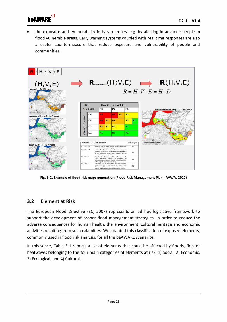
D2.1 – V1.4 D2.1 – V1.0
Page 25
the exposure and vulnerability in hazard zones, e.g. by alerting in advance people in
flood vulnerable areas. Early warning systems coupled with real time responses are also
a useful countermeasure that reduce exposure and vulnerability of people and
communities.
Fig. 3-2. Example of flood risk maps generation (Flood Risk Management Plan - AAWA, 2017)
3.2 Element at Risk
The European Flood Directive (EC, 2007) represents an ad hoc legislative framework to
support the development of proper flood management strategies, in order to reduce the
adverse consequences for human health, the environment, cultural heritage and economic
activities resulting from such calamities. We adapted this classification of exposed elements,
commonly used in flood risk analysis, for all the beAWARE scenarios.
In this sense, Table 3-1 reports a list of elements that could be affected by floods, fires or
heatwaves belonging to the four main categories of elements at risk: 1) Social, 2) Economic,
3) Ecological, and 4) Cultural.

D2.1 – V1.4 D2.1 – V1.0
Page 26
Table 3-1. Elements at Risk
Macro category
# Element at risk Flood Fire Heatwave
Social E01 Inhabitants
Yes, in particular those living close to the river, or in basements and unable to leave their houses (e.g. due to water blocking exit to the street) or cars.
Yes, in particular those living close to forest biomass & visitors
Yes, due to power blackouts, causing elevators not to work Those unanble (elders, sick people, etc) to leave their houses and are stuck with no A/C Children, Outdoor workers (construction, roofers, migrant workers), Military , Elderly
Economic E02 Public & private buildings
Yes Yes, especially close to the forest
E03 Industrial activities Yes
E04 Communication Infrastructure
Yes Yes Yes (e.g. Affected Public transport lines)
E05 Cars Yes (e.g. parked or moving)
Yes Cars (e.g. parked or moving)
E06 Substations and Pumping stations
Yes Yes substations. Extensive power needs might cause a failure
E07 Telecommunications
Yes Yes
E08 Road and railway
Yes Yes
E09 Agriculture: livestock
Yes
Yes Yes, Livestock
E10 Agriculture: crops and other plants (e.g. Vegetables, Vineyards)
Yes, (oversaturated with water)
Yes Yes, due to drought

D2.1 – V1.4 D2.1 – V1.0
Page 27
Macro category
# Element at risk Flood Fire Heatwave
Ecological E11 Natural habitat Yes Yes
E12 Forest biomass Yes Yes, due to drought
E13 Animals and plants Yes Yes, in protected environment
Yes, in protected environment
E14 Dunes An essential task in this environment due to its weakness
Cultural E15 Historical buildings Yes, in particular those located in the city center
Yes
E16 Historic sites
Yes
E17 Objects of art standing alone or firmly attached as an integral part of buildings
Yes
3.3 Impacts
According to the Common Implementation Strategy Working Group on Floods (WGF 2012)
the Consequences/impacts/effects can be defined as : “An impact points at the economic,
social or environmental damage that may result from a flood. An impact may be expressed
quantitatively or qualitatively. The terms consequence, impact and effect can be used
interchangeably”
A possible classification of these impacts is presented in Table 3-2 wich is an elaboration of
the catalogue of flood consequences proposed in WGF (2012) which integrates the flood
consequences identified in Halcrow (2008), Penning-Rowsell et al. (2005) and Ecodecision
(2006).
D2.1 – V1.4 D2.1 – V1.0
Page 28
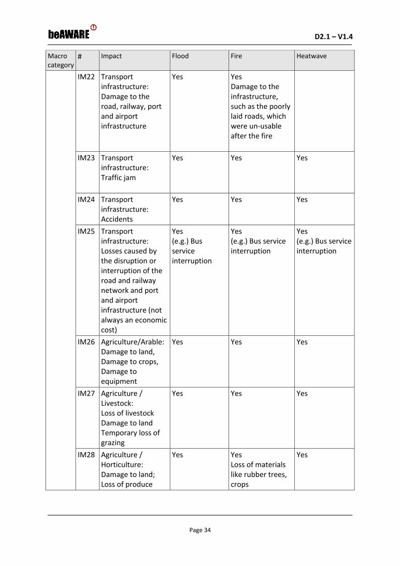
Table 3-2. Impacts
Macro category
# Impact Flood Fire Heatwave
SOC
IAL
IM01
Impact on human health: Quasi direct physical health effects (e.g. Injuries)
Yes Injuries from being knocked over by flood water, thrown against hard objects or struck by moving objects; injuries from over-exertion during the flood (e.g. sprains); hypothermia; cold, coughs, flu, headaches; sore throats or throat infections; skin irritations (e.g. rashes)
Yes Health problems due to exposure to heat & smoke (e.g. respiratory difficulty, burns, shock, and unconsciousness), and malnutrition due to lost crops.
Health problems due to exposure to heat

D2.1 – V1.4 D2.1 – V1.0
Page 29
Macro category
# Impact Flood Fire Heatwave
IM02
Impact on human health: Longer term physical health effects:
Yes Gastro-intestinal illnesses; cardiac problems; respiratory problems (e.g. asthma, chest infections, pleurisy); lacerations, abrasions and contusions; sprains and strains; skin irritations (e.g. rashes, dermatitis, etc.); high blood pressure; kidney or other infections; stiffness in joints; muscle cramps; insect or animal bites; erratic blood sugar level (diabetics); weight loss or gain; allergies (e.g. to mould spores)
Yes Respiratory problems; long term skin problemes (e.g. fire wounds with infections and scar tissue); malnutrition may cause long term effects (e.g. loss of bone density and damage to the organs).
Health problems due to exposure to heat Body becomes unable to regulate itself & sweating mechanism fails; core body temperature rises Symptoms: Very high body temperature Red, hot skin Rapid strong pulse Throbbing headache Confusion– altered mental state Dizziness, nausea, vomiting Unconsciousness

D2.1 – V1.4 D2.1 – V1.0
Page 30
Macro category
# Impact Flood Fire Heatwave
IM03 Impact on human health: Pshycological health effects
Yes Anxiety; panic attacks; increased stress levels; depressions; lethargy / lack of energy; feelings of isolation; sleeping problems; nightmares; flashbacks to the event; increased use of alcohol or drugs; Anger/tantrums; Mood swings/bad moods; increased tensions in relationships (e.g. more arguing); difficulty concentrating on everyday tasks; thoughts of suicide
Yes Anxiety; panic attacks; increased stress levels; depressions; lethargy/lack of energy; sleeping problems; nightmares; flashbacks to the event; increased use of alcohol or drugs; anger/tantrums; mood swings/bad moods; increased tensions in relationships (e.g. more arguing); difficulty concentrating on everyday tasks; thoughts of suicide. The pshycological heath effects depends on the affected person (e.g. their life situation, experience, and copingmechanism)
Yes (e.g. due to Overcrowded public places)

D2.1 – V1.4 D2.1 – V1.0
Page 31
Macro category
# Impact Flood Fire Heatwave
IM04
Impact on human health: Death
Yes (e.g. for drowning or severe Injuries)
Yes (e.g. severe injuries caused by heat and smoke, severe malnutrition, overwhelming pshycological effects such as depression)
Yes
IM05 Impact on family life and social relations: Difficulties in meeting basic needs. Difficulties in recovering the house. Difficulties in coping with relatives suffering from health problems. Evacuation from the area. Loss of time and recreational opportunities. Disruption of financial situation.
Yes Yes
Yes
IM06 Disruption of community services (Education Governance Health and home care Security)
Yes Yes Yes
IM07 Loss of memorabilia and irreplicable items
Yes Yes

D2.1 – V1.4 D2.1 – V1.0
Page 32
Macro category
# Impact Flood Fire Heatwave EC
ON
OM
IC
IM08 Buildings (residential) and contents: Damage to the building frabric
Yes Yes
IM09 Buildings (residential) and contents: Damage to contents (domestic appliances; electrical appliances; furniture and furnishings; clothes; …)
Yes Yes
IM10 Damage to vehicles Yes – water & mud
Yes – ashes & smoke
IM11 Economic activities: Damage to the building frabric
Yes Yes
IM12 Economic activities: Damage to building services
Yes Yes
IM13 Economic activities: Damage to movable equipment
Yes Yes
IM14 Economic activities: Damage to fixtures and fittings
Yes Yes
IM15 Economic activities: Damage to stocks
Yes Yes Yes
IM16 Economic activities: Loss of earnings
Yes Yes Yes
D2.1 – V1.4 D2.1 – V1.0
Page 33
Macro category
# Impact Flood Fire Heatwave
IM17 Public utilities and related infrastructure: Damage to power plants
Yes Yes Yes (as consequence people can be trapped in elevators of stuck in elevators or in houses without A/C)
IM18 Public utilities and related infrastructure: Damage to water and sewage treatment plants
Yes
IM19 Public utilities and related infrastructure: Damage to electricity, gas, district heat, water and telecommunications transmission infrastructure
Yes Yes
IM20 Public utilities and related infrastructure: The phone lines are down or tied up or simply not working.
Yes Yes
IM21 Public utilities and related infrastructure: Losses caused by the disruption of electricity, gas, district heating, water and telecommunication services
Yes Yes Yes
D2.1 – V1.4 D2.1 – V1.0
Page 34
Macro category
# Impact Flood Fire Heatwave
IM22 Transport infrastructure: Damage to the road, railway, port and airport infrastructure
Yes Yes Damage to the infrastructure, such as the poorly laid roads, which were un-usable after the fire
IM23 Transport infrastructure: Traffic jam
Yes Yes Yes
IM24 Transport infrastructure: Accidents
Yes Yes Yes
IM25 Transport infrastructure: Losses caused by the disruption or interruption of the road and railway network and port and airport infrastructure (not always an economic cost)
Yes (e.g.) Bus service interruption
Yes (e.g.) Bus service interruption
Yes (e.g.) Bus service interruption
IM26 Agriculture/Arable: Damage to land, Damage to crops, Damage to equipment
Yes Yes Yes
IM27 Agriculture / Livestock: Loss of livestock Damage to land Temporary loss of grazing
Yes Yes Yes
IM28 Agriculture / Horticulture: Damage to land; Loss of produce
Yes Yes Loss of materials like rubber trees, crops
Yes

D2.1 – V1.4 D2.1 – V1.0
Page 35
Macro category
# Impact Flood Fire Heatwave
IM29 Agriculture / Forestry: Damage to forestry
Yes Yes Loss of forest resources.
Yes
ECO
LOG
ICA
L
IM30 Impact on the quantity and quality of ecosystem goods and services
Yes (Power cuts related to floods may disrupt water treatment and supply plants thereby increasing the risk of water-borne diseases as described)
Yes air pollution, waters with forest fire ashes, crop pollution loss of biomass, landscape impact
Loss of land, such as the local forest gardens
Yes, microclimate of the city will be affected.
CU
LTU
RA
L IM31 Damage to build-up
heritage Damage to parks and gardens Damage to archaeological sites
Yes (e.g. Damage to artworks)
3.4 Difficulties
“Difficulties” are factors preventing the stakeholders from operating efficiently during crisis
management. During the first phase of the Project, stakeholders (Municipalities,
Regional/local Civil Protection Agencies, etc.) concerned with integrated risk management
(floods/flash floods/fires/heatwaves) were identified and interviewed, focusing on their
needs and the current gaps both in the awareness and command and control aspect of the
disaster response. In detail the following list of difficulties resulted:

D2.1 – V1.4 D2.1 – V1.0
Page 36
Table 3-3. Difficulties
# Description Flood Fire Heatwave
D01 Uncertainty of weather forecasts
Especially in case of flash floods in small catchment areas caused by small scale rain events, more difficult to be evaluated. Low resolution of weather forecasts (> 5kmq). Increasing uncertainty for forecasts characterized by wider time windows (> 3 days)
Especially for a areas characterized by o special micro-climate conditions
Especially for a small area in real time
D02 Uncertainty of forecast/ prediction models
Lack of recorded environmental data (flood areas, water depth) to calibrate Hydrological-hydraulic forecast models.
Fire can start in different ways (e.g. natural or human causes)

D2.1 – V1.4 D2.1 – V1.0
Page 37
# Description Flood Fire Heatwave
D03 Missing decision-support system platform: - Visualized reports; - Environmental
sensor data; - Number of people in
danger; - Availability &
location of rescue teams in the field
Yes -to know where people are really in danger in order to send rescue teams; - to know the number of people and assets that are (or may be)affected by the flood; -to know real time environmental data (from standard sensors and meteorological radar); - to know flood model forecasts; - to Visualize pertinent information provided via mobile Apps, calls, text messages, as well as social media streams
Yes - to know where people are really in danger in order to send rescue teams or ordering evacuations/confinment; - to know the number of people and assets that are (or may be)affected by the forest fire; - to Visualize pertinent information provided via mobile Apps, calls, text messages, as well as social media streams
Yes - to know where people are really in danger in order to send rescue teams; - to know the number of people and assets that are (or may be)affected by the heatwave; - to Visualize pertinent information provided via mobile Apps, calls, text messages, as well as social media streams

D2.1 – V1.4 D2.1 – V1.0
Page 38
# Description Flood Fire Heatwave
D04 Missing Automatic warnings & recommendations - Citizens - First responders
- Send location of safe places; - Send warnings in order to avoid possible interferences with ways to be used only by civil protection volunteers; - to warn people of a river overtopping and/or breaking; - to warn people on the progress of flooding and on flooded underpasses; - to warn people approaching a flooded area
Yes - Send location of safe places; - Send warnings in order to avoid possible interferences with first responders; - to warn people of pre-emergency level 3 establishment (extreme fire risk) ; - To inform people of forbidden activities/behaviours; - To inform people of self-protection measures; - to warn people approaching a burning area
Yes - Send location of places of relief; - Send warnings to people about imminent heatwave
D05 Assign tasks to first responders
Yes - Assign tasks to first responders and evaluate their evolution in real time
Yes - Assign tasks to first responders and evaluate their evolution in real time
Yes - Assign tasks to first responders and evaluate their evolution in real time
D06 Limited visibility Monitor river level, levee overtopping & breaking and rainfall, especially at night
Monitor fire evolution, satellite cameras access.
D07 Detect people and cars In the river and in flooded road underpass
Yes, in the forest area
D08 Limited time between model forecast and the implementation of first responder actions
Yes Yes Yes

D2.1 – V1.4 D2.1 – V1.0
Page 39
# Description Flood Fire Heatwave
D09 Overcrowded in summer time and vacation weekends
Could obstruct the arrival of first responders and make evacuation more difficult
D10 Difficulty in predicting a blackout
Yes
D11 Handling traffic, even before a blackout occurs
Yes
D12 Dealing with people that will gather in multiple locations across the city
Yes
D13 Pin-point exact location(s) where rescue teams are actually needed
Yes Yes, due to uncertainty of forest fire forecast. Weather conditions may rapidly change.
Yes, multiple reports from various sources may make it difficult to assess if several rescue teams are required for several different groups of people in danger, or whether all reports are referring to the same incident and one rescue team can handle the situation
D14 Dark spots where communications may be lost
Yes Yes
Since beAWARE should address any Flood, Fire, and Heatwave at any geographical location this section was dedicated to the description of the general risks, impacts, and difficulties related to any of these kind of events. In order to demonstrate how the beAware solution will be capable of managing these general challenges, three demonstation scenarios and use-cases will be implemented in Vicenza, Thessaloniki and Valencia. These scenarios and use-cases that are representative for generic issues related to Flood, Fire, and Heatwave are described in the following sections 4 and 5. Finally, starting from current gaps and difficulties

D2.1 – V1.4 D2.1 – V1.0
Page 40
related to these real crisis management problems, expectations from the beAWARE system will be translated in terms of users requirements as reported in section 6.

D2.1 – V1.4 D2.1 – V1.0
Page 41
4 Operational Scenarios
4.1 SCN_1: Flood
Description of Flood Demonstration site
The catchment of the upper Bacchiglione River, closed at Ponte degli Angeli in the historical
centre of Vicenza (Fig. 4-1), is located in the north of the Veneto Region, a plain that is
fringed by the Alpine barrier at a distance of less than 100 km to the north of the Adriatic
Sea (Barbi et al., 2012).
Fig. 4-1. The Bacchiglione Catchment closed at Vicenza
With regard to the precipitation climatology, the southern part of this plain is the drier, with
approximately 700–1000 mm of mean annual rainfall, whereas more than 2000 mm are
measured close to the pre-alpine chain. Obviously, these differences are mainly related to
the mountain barrier and its interaction with southerly warm and humid currents coming
from the Mediterranean Sea (Smith, 1979). Indeed, the topography of the region rises from
the southern plain at about 30 m above sea level (a.s.l.) to about 1500–2200 m a.s.l. in the
first orographic barrier, the pre-alpine chain, and then further to the north to the Dolomites,
a mountain massive that peaks at over 3000 m a.s.l. In the northern part of the Bacchiglione
catchment, the terrain elevations raise from 250 to 1000 m a.s.l. in less than 1 km, with
slopes up to 70%. A significant portion of the annual rainfall often concentrates into very
short periods of time in the form of what often turns out to be an extreme event with deep
convection playing a central role (Barbi et al., 2012; Rysman et al., 2016). As a consequence,
severe flooding event have threatened agricultural and urban areas in the recent years (e.g.
Scorzini and Frank, 2015), since the upper Veneto plain is a highly populated and urbanized
area. These floods are characterized by low response time (lower than 12 hours) and are
also triggered by snowmelt.

D2.1 – V1.4 D2.1 – V1.0
Page 42
In detail, the territory of the Vicenza Municipality lastly was affected by a relevant flood
event that happened between 31st October and 1st November 2010. It was triggered by
extreme rainfall and snowmelt in the upper Bacchiglione basin: over 500 mm rainfall was
recorded.
The Vicenza city centre, a very busy residential and commercial area, was submerged due to
the overtopping of the levees at the "Ponte degli Angeli" river section. The Fig. 4-2 shows the
map of the cumulated precipitations in the Veneto Region and the time series of water
levels reached by the Bacchiglione River in Vicenza at the "Ponte degli Angeli" river section.
Fig. 4-2. a) The 2010 flood event: a) Cumulative precipitation b) Bacchiglione River levels at Ponte degli Angeli Bridge in Vicenza
Fig. 4-3. Levee breach upstream of Vicenza (a) and flooding of Vicenza City (b) during the 2010 flood
a)
b)
a) b)

D2.1 – V1.4 D2.1 – V1.0
Page 43
Fig. 4-4. Flooded area in Vicenza after the 2010 flood compared with the 2012 (a) and the 2013 (b) floods
Source: Municipality of Vicenza: http://www.comune.vicenza.it/
In other zones floods were caused by levee breaks and surcharge of the existing urban
drainage system (Fig. 4-3). The plots reported in Fig. 4-4 show the overall flooded area in
Vicenza during the 2010 event compared with other minor flood events occured in
November 2012 and May 2013.
The main end-users in the pilot are:
The Mayor
Municipal group of Vicenza Civil Protection;
National Association of Carabinieri (Italian Army Police);
National Alpine Trooper Association;
Coordination of Voluntary Associations of Civil Protection, Province of Vicenza;
Italian Red Cross
Fire Brigades
Local Police
Regional and local authorities
AAWA
A summary of the damages encontered during the 2010 flood for all the Veneto Region is
reported in the Table 4-1.
a) b)

D2.1 – V1.4 D2.1 – V1.0
Page 44
Table 4-1. The total damages in Veneto Region after the 2010 flood Source: Veneto Region (2011)
Damages Numbers
Deaths 3
People involved 500000
Families 7708
Citizens who had to leave their homes 3500
Companies 2114
Total damage reported through Municipalities for private citizens, businesses and public works
426 million of Euros
Livestock drowned 151000
Municipalities who reported damage 262
Municipalities who reported a damage higher than one million euros
61
In particular the cost of final damages declared by the Vicenza Municipality was 62 million of
euros (Veneto Region, 2011). It was the higher cost over all the Veneto Region
municipalities. In Table 4-2 the affected assets and the main features of the 2010 flood are
reported only for the the City Center of Vicenza.
Table 4-2. Damages to the City Center of Vicenza during the 2010 Flood Event
Source: Municipality of Vicenza: http://www.comune.vicenza.it/
Assetts Number
Assets 12.061
Residents 1.408
Buildings 287
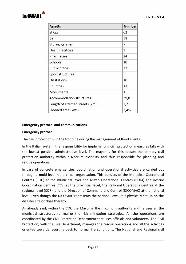
D2.1 – V1.4 D2.1 – V1.0
Page 45
Assetts Number
Shops 62
Bar 58
Stores, garages 7
Health facilities 3
Pharmacies 24
Schools 10
Public offices 22
Sport structures 5
Oil stations 10
Churches 13
Monuments 1
Accommodation structures 39,0
Length of affected streets (km) 2,7
Flooded area (km2) 3,4%
Emergency protocol and communications
Emergency protocol
The civil protection is in the frontline during the management of flood events.
In the Italian system, the responsibility for implementing civil protection measures falls with
the lowest possible administrative level. The mayor is for this reason the primary civil
protection authority within his/her municipality and thus responsible for planning and
rescue operations.
In case of concrete emergencies, coordination and operational activities are carried out
through a multi-level hierarchical organisation. This consists of the Municipal Operational
Centres (COC) at the municipal level, the Mixed Operational Centres (COM) and Rescue
Coordination Centres (CCS) at the provincial level, the Regional Operations Centres at the
regional level (COR), and the Direction of Command and Control (DICOMAC) at the national
level. Even though the DICOMAC represents the national level, it is physically set up on the
disaster site or close thereby.
As already said, within the COC the Mayor is the maximum authority and he uses all the
municipal structures to realize the risk mitigation strategies. All the operations are
coordinated by the Civil Protection Department that uses officials and volunteers. The Civil
Protection, with the Fire Department, manages the rescue operations and all the activities
oriented towards resorting back to normal life conditions. The National and Regional civil

D2.1 – V1.4 D2.1 – V1.0
Page 46
protection authorities are involved when the event assumes a high gravity level. In these
cases often the army is involved in addition to the National Civil Protection System.
In particular, the Vicenza municipality has defined a very clear protocol in response to
flooding (the Protocol is described in detail in the official Civil Protection Plan Document
http://www.comune.vicenza.it/file/101876-pde.pdf).
There are three critical levels before the flood expected event
(http://www.comune.vicenza.it/uffici/dipterr/infrastruttureeverdepubblico/protcivile/ris
chioallagamenti.php):
1) The first phase is the Ordinary Criticality, here begins the monitoring activities. This
state is named "ATTENTION”: is declared when the AMICO Flood Forecasting System
(Ferri 2012, Mazzoleni 2017) shows potential risk situations in the next 3 days.
2) The next phase is the Moderate Criticality. This state is named " PRE - ALARM" (3-5
hours prior to the Maximum forecasted river Level). In this phase the first acoustic
alert is activated. At this step, all the programmed prevention measures are taken
(closing bulkheads, artificial embankments, preparation of the lamination basins,
etc.). Most of these are triggered by observed river levels at the bridge of “Ponte
Degli Angeli” with water level varying between 2m to 5.6 meters.
3) The third level is the High Criticality; this state is named “ALARM": it's activated when
the civil protection foresees that a flood will take place within an hour. The second
acoustic alert is activated and all the citizens resident in a soon to be flooded zone
are instructed to leave their house. All the rescue resources are activated. When the
flood happens, vehicles and men are deployed to give assistance to the population.
The end of the emergency corresponds to the state "END ALARM". A third acoustic alert is
activated. After the event the activities are oriented to remove water and mud from
buildings and streets. Later a reconnaissance of the damages is necessary.
Communication
Internal communication (between the COC and first responders): The emergency is managed
using traditional telecommunications systems / institutional (radio, telephone, fax, etc.).

D2.1 – V1.4 D2.1 – V1.0
Page 47
External communication (between the COC and the Community):
Number for emergency call by citizens:
• Local Police number 0444545311 (if necessary it can also be activated the free
municipal number 800127812).
• Other useful numbers:
Firemen: 115
Ready Health Intervention (SUEM): 118
Carabinier: 112
State Police: 113
The alarm systems:
• Acoustic warning system: they warn the population of the central areas
(http://www.comune.vicenza.it/uffici/dipterr/infrastruttureeverdepubblico/protci
vile/sirenediallarme.php);
• Speakers: outside the area covered by the acoustic warning system, the states of the
PRE-ALARM and ALARM are announced by means of a speaker transiting in the
affected areas.
Communications systems by the COC during an emergency:
• Warnings are sent to people registered to the "text service". In order to register
people need to send previously a text message, including name and surname, to the
number 392 7338475
• Warnings are published on the website of the Bacchiglione river
(www.bacchiglione.it) and on the web site of the city (www.comune.vicenza.it) and
on its Facebook and Twitter accounts (https://www.facebook.com/cittadivicenza ,
@CittadiVicenza)
• Warnings are provided by the Office of Public Relations whose phone number is
0444221360.
• Warnings are provided by the local media, by local television, from websites of local
newspapers and local online newspapers.
Available resources
GIS data (shape file and grid format):

D2.1 – V1.4 D2.1 – V1.0
Page 48
• Admninistrative_boundary
• Flood_Risk_Management_Plan
• Hystorical_FLOOD_AREAS
• Study_area_Vicenza
• Technical Regional Map
• Veneto_Hydraulic_network
• Veneto_road and rail networks
• Aerial photos of the study area
• Digital terrain model of the study area
Hydro meteorological data:
• Shape file of the hydro meteorological stations included in the Bacciglione River Basin
• Time series of rainfall, temperature, wind velocity, pressure, water level, snow level
(csv, hourly time step from 1992 until now)
• Snow cover from satellite images (grid, 2000-2011)
Social:
• Database of the reports sent by the Mobile app during a series of exercises organized
as a part of the FP7 WeSenseIt Project (including text and images)
• Backup of reports from the Facebook and Twitter accounts of the Municipality and
from its website
• Videos registered during the last flood events in Vicenza
• Weblinksconcerning the real-time description of the last flood events in Vicenza
AMICO Flood Early Warning System:
• Real time flood forecasts (time series of the water level for each modelled section
along the river) (txt)
• Shape file of the river network and modelled river cutline
• Previous flood warning reports elaborated on basis of the AMICO results (pdf)
VIDEOCAMERAS:

D2.1 – V1.4 D2.1 – V1.0
Page 49
• Historical records of the 2 video cameras in Vicenza along the Bacchiglione Rivers
real time streaming data of the 2 video cameras in Vicenza along the Bacchiglione
Rivers
• Possibility to install new cameras (better if they are mobile cameras)
4.2 SCN_2: Forest Fire
Description of the Valencia Demonstration site
Fig. 4-5. La Devesa de L'albufera
La Devesa de L´Albufera (also known as La Dehesa del Saler) is a natural park (special
protection area) located 8 km. away from the city of Valencia. It is a Mediterranean forest
with a line of dunes that has been molded over the centuries after the isolation of the
Albufera lake from the Mediterranean sea.It is composed of 850 Hectares of Mediterranean
pines, palms, kermes oak, mastic scrubs and honeysuckle. This environment attracts many
animals, such as birds, small vertebrates and amphibians. Every year hundreds of bird
species migrate from Africa to North Europe, and this place becomes a perfect spot for them
to recover from this long journey.
The Mediterranean climate is characterized by dry summers and mild, moist winters.
Mediterranean climate ecosystems are among the most fire-prone in the world.
The territory of La Devesa de l´Albufera (Valencia) has been affected by some fires in the
past. Concretely, in 2015, a fire burned 6 hectares. This event, occurred in August 14th, and
had a quick response by the firefighters thanks to an early warning and the proximity of the
firefighters command centre. According to local media sources, the time-response between
warning and firefighters extinguishing tasks was 12 minutes.

D2.1 – V1.4 D2.1 – V1.0
Page 50
Fig. 4-6. La Devesa de L'albufera (Maps)
Fig. 4-7. A typical fire that occured at La Devesa de L'albufera and precipitations´chart (monthly)
Fig. 4-8. Forest fires chart per week in La Devesa
0
10
20
30
40
50
60
70
80
0
10
20
30
40
50
60
70
80
Monday Tuesday Wednesday Thrusday Friday Saturday Sunday
FIR
E N
UM
BER
S
AR
EA (
ha)
FOREST FIRES STATISTICS PER WEEK FIRE NUMBERS AREA

D2.1 – V1.4 D2.1 – V1.0
Page 51
Fig. 4-9. Forest fires chart per month in La Devesa
Fig. 4-10. Forest fires chart per year in La Devesa
Once the fire has started, adverse climate conditions such as low humidity, high
temperatures and high speed winds can promote a quick propagation of the fire. For
example if these values reaches 30-30-30 (<%humidity, >ºC and >km/h wind), the fire risk is
considered extreme.
0
10
20
30
40
50
60
0
10
20
30
40
50
60
FIR
E N
UM
BER
S
AR
EA (
ha)
FOREST FIRES STATISTICS PER MONTH FIRE NUMBERS AREA
0
5
10
15
20
25
0
5
10
15
20
25
30
35
40
45
19
68
19
70
19
72
19
74
19
76
19
78
19
80
19
82
19
84
19
86
19
88
19
90
19
92
19
94
19
96
19
98
20
00
20
02
20
04
20
06
20
08
20
10
20
12
20
14
20
16
FIR
E N
UM
BER
SUR
FAC
E (
ha)
FOREST FIRES STATISTICS PER YEAR FIRE NUMBERS AREA (ha)

D2.1 – V1.4 D2.1 – V1.0
Page 52
Emergency protocol and communications
There are two different emergency levels: one with preventive tasks in which specific
emergency has not started (levels 1 to 3), and another one in which the emergency (forest
fire in this case) has already started (levels 0 to 3).
The State Meteorological Agency of Spain (AEMET), through the Meteorological Center
(CMT) in Valencia, determines each day, for a 48 hour period, a daily rate of forest fire
hazard (combined index of ignition and propagation) by area, based on three levels of
severity. From this index and other socio-cultural factors and situations that can raise the
level of severity, the Generalitat (regional government) declares, through the Autonomous
CCE, the corresponding level of pre-emergence:
Level 1 LOW-MEDIUM RISK OF FOREST FIRES: Mobilization of the monitoring and
dynamic regional network, through volunteers, forest rangers, etc.
Level 2 HIGH RISK OF FOREST FIRE: In addition to the above resources, BRE (Rural
Emergency Squad), deterrent surveillance with air regional and state resources.
Level 3 EXTREME RISK OF WILDFIRE: In addition to the resources mobilized in Level 2,
it will also mobilize the Guardia Civil, Autonomic Police, municipalities, brigade
Level 3 Pre-emergency procedure
Once level 3 pre-emergency level notification is received through the autonomic Command
Control emergency coordination center (CCE) the Mayor, as Civil Protection Chief of the
municipality of Valencia, will mobilize the resources in order to set vigilance services in the
most sensitive areas. Firefighters Command Control Centre (CECOM) will warn not only
theirown resources, but also the rest of municipal resources.
Besides this, the Mayor will issue a proclamation in which this situation is notified, indicating
that pre-emergency level 3 (extreme) has been established, and warning that compulsory
preventive measures referred to in Decree 98/1995, of May 16 should be taken into
account. Among these, any fire authorization previously done is cancelled, and circulation of
people and/or vehicles may be restricted. Any work or activity that can constitute a risk may
be suspended as well.

D2.1 – V1.4 D2.1 – V1.0
Page 53
Fig. 4-11. Emergency protocols and communications
Table 4-3.Pre-emergency levels
LEVEL 1 LOW-MEDIUM FOREST FIRE RISK
LEVEL 2 HIGH FOREST FIRE RISK
LEVEL 3 EXTREME FOREST FIRE RISK
Fig. 4-12. Pre-established days with level 3 pre-emergency (2015)
Besides these pre-established days in the calendar, in the year 2015, for instance, every
weekend and bank holiday from April 14th to October 18th, pre-emergency level 3 is
established in case that AEMET (Spanish weather agency) determines level 2 out of 5
(moderate level). It should be added to all these days the ones in which AEMET determines
extreme risk of fires.
PHASES OF EMERGENCY AT A LOCAL LEVEL
LEVEL 0:

D2.1 – V1.4 D2.1 – V1.0
Page 54
Level 0 refers to fires that can be controlled using the fire-fighting resources foreseen in
the Local Emergency Plan, and which pose no danger to persons or properties.
LEVEL 1:
Fires can be controlled with the mass extinction of the local emergency plan but sees
the need for protective measures for people and goods different to forest nature.
LEVEL 2:
Level 2 refers to fires which extinction needs to incorporate regional resources, at the
request of the Director of the Emergency Plan (Mayor), and under the Special Plan
against Forest Fire Risk (PEIF). It also establishes the possibility of allocating extra
resources, when necessary, from the autonomic community (CCAA).
LEVEL 3
Level 3 refers to fires in which the deployment of the means envisaged in the PEIF is
necessary, and the direction thereof is assumed by the structure provided therein, in
this case the Security and Emergencies Response Agency Director of the Valencian
Community. In the early stages of the fire, an initial assessment is carried out (Level 0 or
1) by the current head of the local Fire Brigade (chief technical officer of the PMA) and
the PMA (Advanced Command Post) is set up. It constitutes the post technical direction
of the work of control and extinction of a fire.
THRESHOLD TRIGGERING
As stated in the use case, according to weather conditions and other socio-cultural factors,
there are three pre-emergency risks of forest fire levels, where the third pre-emergency
level correspondes to extreme forest fire risk. In this case, all resources are mobilized in
order to perform dissuasive surveillance in sensible areas, as well as from this moment, the
population must be advised so that they take extreme cautions. Note that any activity with
fire will be forbidden.
Therefore, beAWARE system will send messages - once pre-emergency level 3 is declared.
On this occasion, the messages are delivered to the population in general to take preventive
measures in order to avoid the forest fire taking place.
Furthermore, forest fires are also classified in different levels according to their seriousness,
from level 0 to level 3, once they have been produced. Level 1 forest fire is declared when
the fire development is likely to require protective measures for people and goods (assets
different from forest nature). Consequently, during the forest fire beAWARE system must
consider level 1 an activation threshold in order to send messages to the residents in the
areas in danger and citizens in general. These messages are supposed to give information
about self-protection measures and even advise to be ready for eventual evacuation.

D2.1 – V1.4 D2.1 – V1.0
Page 55
In a third case, the forest fire can spread and endanger resident areas so people who live
there must be evacuated. Evacuation orders are currently given by loudspeakers or just in
place. beAWARE system will contact people in danger exclusively by sending them messages
which will order the evacuation.
Fig. 4-13. Emergency action scheme
The final declaration of emergency will correspond to the emergency leader (PMA Director,
Technical, or Plan Director) and will be communicated to the mobilized units (Intervention,
Security, Logistics, Health).
Internal communications
Between Valencia Local Police Command Control Centre (CISE) and Firefighters Command
Control Centre (CECOM) there is a direct phone line.
112 (Emergencies coordination center) launches an on line description of the incident which
is shared with first responders except with Valencia Local Police. The communication
between 112 and PLV is direct by phone.

D2.1 – V1.4 D2.1 – V1.0
Page 56
All first responders have portable communication equipment for internal messages.
Regarding PLV officers, they use equipment provided with GPS antenna (geo localized units).
External communications (between Emergencies services and citizens)
112 (Emergencies coordination center)
092 Valencia Local Police resources
080 Firefighters
062 Guardia Civil (it has police competences in all the country)
085 Forest fires
900123505 Traffic Department Center
During an emergency warnings are posted by 112 (@GVA112), PLV (@policialocalvlc) and
Firefighters (@bomberosvlc) through social media (Twitter).
Available resources
Preventive resources:
DISTER (Infrared sensors detection system)
The Devesa Natural Park used to have an automatic fire detection system whose objective
was to identify and locate the fires during their first moments 24x7x365. This system,
commonly called DISTER (Fire Detection by Thermal Sensors), was initially developed by the
Polytechnic University of Valencia through a collaboration agreement with the Fire Service
of the City of Valencia.
The system had eight thermal cameras and six vision cameras distributed in three
observation posts. This configuration enables monitoring approximately 85% of the total
surface of the natural park directly, through the use of fixed thermal cameras and the
remaining 15% has a maximum window of less than two minutes in the worst case.
However, DISTER did not work properly.
In fact, this detection system is out of work currently although some visual fixed cameras are
still working and Valencia Firefighters are working in a new system which is supposed to
include cameras, temperature sensors and micro-weather stations placed in different areas
according to micro-climate issues.
Description of Forest fire measures in Tisvilde Hegn in Denmark
This case presents a forestry area located within the area of Frederiksborg Fire and Rescue Service (FBBR) in Denmark. FBBR work in the field of first responders and civil protection and are responsible for fire extinguishing in the forest called Tisvilde Hegn. The knowledge

D2.1 – V1.4 D2.1 – V1.0
Page 57
presented in this case is useful to support the generic use of the beAWARE system in different territorial context. The responsible authority for protection measures in the forests is the Nature Agency governed by the Ministry of Environment and Food of Denmark. Protective natural barriers such as controlled combustions and firebreaks in several of the forests have been created. The image below is the forest of Tisvilde Hegn located in the area of FBBR.
Fig. 4-14. Map of the forest Tisvilde Hegn. The bright green are cleared areas to help prevent and fight fires.
Source: http://naturstyrelsen.dk/drift-og-pleje/driftsplanlaegning/nordsjaelland/omraadeplaner/tisvilde-hegn/
In case of a huge forest fire the coordination is gathered at different hierarchal levels on a
local and a regional level. On a local level a KST (Command Station) will be gathered nearby
the damage site. Here you gather the different agencies involved (police, fire and rescue
services, other agencies etc.) which is very important to make a mutual effort in
coordination of the response. If the fire is severe enough, which means several fire stations
involved, and several municipalities, an LBS (Local Preparedness Staff) will be created where
different agencies also will be gathered, just on a more regional level. The aim of the LBS is
to overall handle and coordinate the available resources and make sure to dispatch them in
the most adequate way in relation to the situation in the affected area.
The operational process will be activated by a telephone call to 112 from someone spotting
the fire. This will activate an alarm at the fire and rescue services in the local area. As they
respond to the fire incident and assess the situation, they will acknowledge the fire is too big
to handle and call for assistance. When a lot of first responders are involved in a fire
incident, from different fire stations, and the fire is very big, the KST (command station) will
be established as soon as possible to be able to handle the situation in the best way possible
from the beginning. When they realize that the LBS needs to be activated, the leading
authorities will do so in order to coordinate in a bigger scale.

D2.1 – V1.4 D2.1 – V1.0
Page 58
Every summer the Danish Metrological Institute (DMI) provides a Drought Index, which show
the risk of drought and how severe the drought is. Basically, how dry the ground and fuels
on the ground is. This is used by the fire services to assess the risk of fires in the nature and
give directions to the public in relation to the risk. The drought index could look like the
image below on a summer day:
Fig. 4-15. Example of drought index from DMI
Source: https://www.dmi.dk/nyheder/arkiv/nyheder-2013/7/toerkeindeks-er-tilbage-paa-dmidk/
4.3 SCN_3: Heatwave
Description of Thessaloniki Demonstration site
The scenario will take place in the wide area of Thessaloniki, which consists of urban,
suburban and forest areas. Thessaloniki is the 2nd largest city in Greece and on its North-East
side is located a suburban forest. Based on a study made in 2013 regarding the density of
population in the cities in Greece, the urban complex of Thessaloniki is in the highest
population density level in Greece with over 9000 people/km2.

D2.1 – V1.4 D2.1 – V1.0
Page 59
Fig. 4-16. Map of Thessaloniki
The area of Thessaloniki was chosen because according to various studies conducted, the
projection of average number of summer days exceeding 40.6 °C over the next years is
increasing significantly and additionally the area of Thessaloniki is in the higher rank of the
scale, as shown in Fig. 1-3 and Fig. 4-17. Therefore, appearences of heatwaves in the area of
Thessaloniki are expected to increase.

D2.1 – V1.4 D2.1 – V1.0
Page 60
Fig. 4-17. Projected frequency of days with apparent temperatures above 40.6
oC across Europe in 2100
5
Furthermore, the level of humidity in the area of Thessaloniki and especially in the center of
Thessaloniki during the summer period is very high6 which has as a result the parallel
increase of the heat index, as shown in the table reported in the Fig. 5-19.
According to the proposed scenario, a heatwave will strike during summer and more
specifically near the end of August and it will last for a period of 4 days.
The temperatures during that period will be over 37 °C, with an average during the day of 31
°C minimum, and the phenomenon will be very intense, especially inside the city, where the
heat index is very high.
In order for all relevant authorities (Municipalities, Fire Department, Hospitals, Civil
Protection) to be prepared to address properly the upcoming phenomenon and its
consequences, they need to be alerted based on the meteorological forecast the soonest
possible and they need to have as many information as possible regarding its progression
and the probability of potential impacts.
The side-effects and the problems that are foreseen to occur during the period of the
heatwave are significant and diverse. Therefore a wide range of first responders might be
5 http://www.nature.com/news/2010/100517/full/news.2010.238.html
6 http://mail.meteothes.gr/wxhumiditysummary.php?r=wxhumiditysummary.php

D2.1 – V1.4 D2.1 – V1.0
Page 61
involved in order to address any possible impacts and to minimize their result and all
potential incidents that require effective management. Additionally volunteers will be called
to assist the authorities in the management of the situation.
Moreover, a lot of municipalities in the area of Thessaloniki and of course the Municipality of
Thessaloniki offer places for the public and especially the elders to find shelter during the
daytime when the phenomenon is more intense. For that purpose all municipal authorities
issue announcements informing the public about the places that are available.
Furthermore, the excessive demand on power might cause a blackout which in turn will
cause even more problems that need to be addressed. Traffic chaos is very likely to occur
causing significant problems in the transportation of first responders, ambulances, etc.
People will be stuck in elevators and elder people who cannot use the stairs will be stuck at
homes without air-conditioning.
Last but not least, since the probability for a forest fire to occur during or even after the
period of heatwave is significantly increased, all relative authorities need to be alerted when
that risk is very high in order to address any potential fire outbreak in the nearby forest.
Emergency protocol and communications
Internal (between the Civil Protection and first responders)
The emergency is managed using traditional telecommunications systems / institutional.
Telephone
Radio
Fax
External (between the Civil Protection and the Community)
Alerts are distributed using all possible resources, media and social media, with guides and
advices on how to reduce the effects of the heatwave and how to avoid exposure as well as
with information on where are the places that the public can visit during the day to avoid
exposure to heat.
Useful numbers that the public can use are:
112
Police: 100
Fire department: 199
Ambulance service: 166

D2.1 – V1.4 D2.1 – V1.0
Page 62
Each municipality that provides places with a/c has its own number. For the
Municipality of Thessaloniki the number is 2313 313135
Available resources
Weather data (from various web pages)
Historical data
o Press releases
o Weather data
Civil protection plan to handle the phenomenon
Traffic situation

D2.1 – V1.4 D2.1 – V1.0
Page 63
5 beAWARE Use Cases
5.1 Use Cases for the Flood scenario
UC_101: Declaration of the attention status and continuos monitoring of flood forecasting
This Use Case concerns the declaration of the “ATTENTION” status and the continuous
monitoring of the forecasted level of risk.
Fig. 5-1. Block Diagram of the UC101
Current Status (initial phase of the scenario)
• Before and during the flood
What is known to the beAWARE system already
• Weather forecast
What is happening
• Weather forecasts feed the Flood Early warning system AMICO (EWS), whose results
can be visualized in the Platform
Outcome
• The results of the EWS (river level ) can be visualized in the Platform and show
potential dangerous situations
• The authority (e.g. mayor), based on these results, declares the “ ATTENTION” status
and convenes in formal way the members of the “COC - Municipal Operative Center”,

D2.1 – V1.4 D2.1 – V1.0
Page 64
that will be engaged in monitoring the situation and in the management of the
emergency thanks to the Public-safety answering point (PSAP) platform.
• The authority, based on these results, can continuously monitor the evolution of the
forecasted flood and evaluate the forecasted level of risk.
Example of the visual information that might be presented to the authorities (e.g. spots in a map etc.)
VISUALIZATION DESCRIPTION OF THE VISUALIZATION
MAP of the overtoppings:
List of the report:
Spots in a map (from google map for example), in corresponding to river modelled cross sections, with different colors depending on the overtopping of defined water level thresholds (water level forecasted by AMICO EWS): Colors:
green: not overtopped
yellow: 1st threshold overtopped
orange: 2nd threshold overtopped
red: 3rd threshold overtopped Filters could be applied to the time and the spatial scale.
Below the map the list of overtopping detected is
visualized and ordered by occurrence date and
colored based on the same classification used for
the spot in the map.
Example of the textual information that might be presented to the authorities
From first Responders
From Citiezens
Example of messages that might be presented to the people
None
Example of messages that might be presented to the first responders
None

D2.1 – V1.4 D2.1 – V1.0
Page 65
Example of reports from the first responders that might be presented to the authority
(tasks etc.)
None
The roles under the term authority
Mayor
Mobile application equipment
None
UC_102: Management of new flood emergencies
This Use Case concerns the management of new emergencies reported by citizens and first
responders.
Fig. 5-2. Block Diagram of the UC102
Current Status (initial phase of the scenario)
• During the flood
What is known to the beAWARE system already
• Weather forecast
• Location of the flooded area

D2.1 – V1.4 D2.1 – V1.0
Page 66
What is happening
• A first responder (rescue service) is recording a video of a flooded street in another
location in the city
• Tweets and phone calls are mentioning flooded areas in another location in the city
• Citizens are sending reports on floods with images and text in another location in the
city
Outcome
• The authority (e.g. mayor) move forces to the new location
• The authority (e.g. mayor) sends notifications to citizens approaching the dangerous
areas and suggests alternative ways
• The system defines a new crisis level based on the available data
Example of the visual information that might be presented to the authorities (e.g. spots in a map etc.)

D2.1 – V1.4 D2.1 – V1.0
Page 67
VISUALIZATION DESCRIPTION OF THE VISUALIZATION
MAP:
List of the report filtered and
ordered by submission date:
Spots in a map (from google map for example) with different colors depending on the filter: Filter= sender:
citizens
first responders (civil protection volunteers)
Filter= water depth (evaluated by the beAWARE system from the videos sent by users):
0cm
0-10cm
10-50cm Other possible filters could be related to the subject of the emergencies reports (e.g.: viability...), the time and the spatial scale. Below the map the list of the report, filtered and
ordered by submission date, is visualized.
Virtual regions of interest will be defined by the System, based on the warning received. For example, each message point could be considered as the center of a circle with a radius of 500 m.
Example of the textual information that might be presented to the authorities
From First Responders
ITA ENG
Piazza XX allagata. Richiesta di rinforzi Square XX flooded. More forces required
Macchine e cassonetti trasportati dalla corrente. Chiudere l'accesso alla strada Cars and Dumpsters transported by the flow.
Close the access to the street
Persone in pericolo in uscita dalle autovetture allagate
People, leaving from their cars, in danger

D2.1 – V1.4 D2.1 – V1.0
Page 68
ITA ENG
Rigurgito da rete fognaria. Richiesta di rinforzi dotati di idrovore
Surcharge of the drainage network. More forces required, equipped with pumping stations
From Citizens
ITA ENG
Sottopasso allagato. Una macchina è rimasta intrappolata dentro e il conducente non riesce ad uscire.
Subway flooded. A car is trapped inside, and the driver is not able to leave it
Un albero trascinato dalla corrente si è incastrato nel ponte e il deflusso è impedito. L'allagamento è prossimo.
A tree, transported by the flow, is blocking the bridge's openings. The flow is limited and the river level is reaching the embankment's top
Siamo sul tetto di casa nostra, siamo isolati, ci serve una barca per uscire.
We are on the roof of our home, we are isolated, we need a boat to leave
Le vie del centro si stanno allagando. La gente fa fatica a camminare a causa velocità della corrente.
The city center's streets are going to be flooded. People struggle to walk because of the velocity of the flow.
Alcune persone stanno cercando di spostare la propria macchina per metterle al sicuro ma vengono trascinate via dalla corrente
Some people are trying to move their cars in order to save them, but they are drag away by the flow
Il livello a Ponte degli Angeli ha raggiunto la sponda sinistra e l'acqua sta per sormontare
The water level at Ponte Angeli Bridge reached the left embankment's top and water is going to overtop it
Vicenza in ginocchio! Alluvione in corso!AIUTO!
Vicenza is on its knee! Flood is in progress! HELP!
situazione tragica! una donna morta schiacciata dalle macchine che galleggiavano e una bambina dispersa!
Tragical situation! Dead woman smashed by floating cars and a missing child!
Ho la cantina allagata Flooded basement
Ho una fattoria e gli animali sono stati inondati. Se non arrivano soccorsi perdo tutto.
My farm is flooded and the animals are drowned inside. If rescue teams do not arrive I will lose everything.
Le strade sono fiumi marroni...l'acqua arriva ai finestrini delle macchine...
The streets are brown rivers...the water is reaching the car windows...
l'acqua mi ha portato via il motorino! Water flow took my motorbike away
Example of messages that might be presented to the people

D2.1 – V1.4 D2.1 – V1.0
Page 69
ITA ENG
Alluvione in corso. Allontanarsi rapidamente e in sicurezza dalla zona. Sono stati identificati i seguenti luoghi sicuri non soggetti ad allagamento o esondazione:
via Pforzheim - viale Cricoli (park Cricoli)
via Baden Powell (cittadella degli studi)
via Ragazzi del '99 (parcheggio cimitero)
via Trieste (parcheggio viale del Cimitero)
Monte Berico (piazzale della Vittoria) Park Borgo Berga - nuovo tribunale corso SS Felice e Fortunato – via
Cattaneo (park Cattaneo) via Cattaneo - via dei Cairoli (ex
sedime ferroviario) viale Btg. Framarin (parcheggio Teatro
Comunale) via Btg. Framarin – via Cengio via del Mercato Nuovo (parcheggio
mercato ortofrutticolo) via Btg. Val Leogra (park Dogana) viale Ferrarin (parcheggio centro
culturale San Paolo)
Questo messaggio verrebbe ricevuto in automatico nel caso in cui un cittadino si trova nei pressi di una zona pericolosa
Flood in progress. Escape rapidly and safely. The following safe places were identified:
via Pforzheim - viale Cricoli (park Cricoli)
via Baden Powell (cittadella degli studi)
via Ragazzi del '99 (parcheggio cimitero)
via Trieste (parcheggio viale del Cimitero)
Monte Berico (piazzale della Vittoria) Park Borgo Berga - nuovo tribunale corso SS Felice e Fortunato – via
Cattaneo (park Cattaneo) via Cattaneo - via dei Cairoli (ex
sedime ferroviario) viale Btg. Framarin (parcheggio Teatro
Comunale) via Btg. Framarin – via Cengio via del Mercato Nuovo (parcheggio
mercato ortofrutticolo) via Btg. Val Leogra (park Dogana)
This message will be received automatically by a citizen approaching a dangerous area
Alluvione in corso. SE NON PUOI ABBANDONARE LA CASA SALI AI PIANI SUPERIORI E ATTENDI L’ARRIVO DEI SOCCORSI.
Flood in progress. If you cannot leave your home, reach the highest floors and wait for the rescue teams

D2.1 – V1.4 D2.1 – V1.0
Page 70
ITA ENG
SE SEI IN MACCHINA EVITA DI INTASARE LE STRADE
If you are driving, do not cause traffic jam
NON PERCORRERE STRADE INONDATE E SOTTOPASSAGGI
Do not move in flooded streets and subways
PRESTA ATTENZIONE ALLE INDICAZIONI FORNITE DALLE AUTORITÀ
Follow suggestions by authority
La distribuzione dei sacchi di sabbia è disponibile presso le seguenti postazioni:
Piazza Venti Settembre Ca' Tosate Via del Grande (zona stadio) Viale Ferrarin (lato nord) Piazza Matteotti (vicino all’ostello
della gioventù) San Pietro Intrigogna (piazzale della
chiesa) Viale Fusinato (parcheggio chiesa San
Giorgio) Via Leoni Viale del Brotton/ viale Ferrarin Debba (piazzale della chiesa) Contra' San Pietro (piazzale della
chiesa) Via Sardegna Contra' Santi Apostoli
The distribution of sand packs is available at the following locations:
Piazza Venti Settembre Ca' Tosate Via del Grande (zona stadio) Viale Ferrarin (lato nord) Piazza Matteotti (vicino all’ostello
della gioventù) San Pietro Intrigogna (piazzale della
chiesa) Viale Fusinato (parcheggio chiesa San
Giorgio) Via Leoni Viale del Brotton/ viale Ferrarin Debba (piazzale della chiesa) Contra' San Pietro (piazzale della
chiesa) Via Sardegna Contra' Santi Apostoli
Example of messages that might be presented to the first responders
ITA ENG
Squadra X raggiunga Via XX per aiutare cittadini rimasti intrappolati in macchina in un sottopasso allagato.
Team X reached Street XX to help citizens trapped inside cars in a flooded subway
Squadra X raggiunga Via XX per procedere a rimuovere albero che ostruisce il ponte
Team X reached Street XX to remove a tree blocking the bridge's openings
Squadra X raggiunga Via XX per salvataggio tramite elicottero di persone isolate sul tetto di casa
Team X reached Street XX to save by helicopter people isolated on the roof of their home
Squadra X raggiunga Via XX per salvataggio tramite barca di persona trascinata dalla corrente
Team X reaches Street XX to save by boat a person who is drag away by the river flow

D2.1 – V1.4 D2.1 – V1.0
Page 71
Example of reports from the first responders that might be presented to the authority
(tasks etc.)
None
The roles under the term authority
Mayor
Mobile application equipment
Personal mobile phone
UC_103: Monitoring river water level and assignment of tasks to first responders
This Use Case concerns the assignment of tasks to first responders based on the monitored
water river level.
Fig. 5-3. Block Diagram of the UC103

D2.1 – V1.4 D2.1 – V1.0
Page 72
Current Status (initial phase of the scenario)
• Before the flood
What is known to the beAWARE system already
• Weather forecast
• Predefined alert thresholds of river level
• Location of the forecasted flooded area
What is happening
• A fixed camera, located in correspondence of a river section of interest, records
continuously water level inside the river
• A citizen records video continuously of water level inside the river
Outcome
• Once the river water level overtops predefined alert thresholds, the authority (e.g.
mayor) assigns tasks to first responders
Example of the visual information that might be presented to the authorities (e.g. spots in a map etc.)

D2.1 – V1.4 D2.1 – V1.0
Page 73
VISUALIZATION DESCRIPTION OF THE VISUALIZATION
MAP of the overtoppings:
List of the report:
Spots in a map (from google map for example), in
correspondence of cameras installation, with
different colors depending on the overtopping of
defined water level thresholds (water level
detected by beAWARE tools):
Colors:
green: not overtopped
yellow: 1st threshold overtopped
orange: 2nd threshold overtopped
red: 3rd threshold overtopped Filters could be related on the time and the
spatial scale.
Below the map is visualized the list of the
overtopping detected and ordered by occurrence
date and colored based on the same
classification used for the spot in the map.
MAP of the assignments:
List of the assignments:
Spots in a map (from google map for example)
with the location of the assignments.
Filters could be related on the subject of the
tasks, the time and the spatial scale.
Below the map the list of the assignments,
filtered and ordered by creation date, is
visualized.

D2.1 – V1.4 D2.1 – V1.0
Page 74
Example of the textual information that might be presented to the authorities
From First Responders
o None
From Citizens
o None
Example of messages that might be presented to the people
o None
Example of messages that might be presented to first responders
ITA ENG
Azione: Posizionare Aquadike agli estremi di ponte degli Angeli Posizione : coordinate: Nord , Est indirizzo: Via XX
Action: Place Aquadike at the ends of Ponte degli Angeli Bridge Location : coordinates: North , East address: Street XX
Azione: Posizionare paratie lungo ringhiera largo Goethe Posizione : coordinate: Nord , Est indirizzo: Via XX
Action: Place gates along Goethe street Location : coordinates: North , East address: Street XX
Azione: Posizionare una fila di sacchi lungo via Nervesa della Batttaglia Posizione : coordinate: Nord , Est indirizzo: Via XX
Action: Place a line of sand packs along Nervesa della Battaglia street Location : coordinates: North , East address: Street XX
Azione: Verificare lo stato del terrapieno Posizione : coordinate: Nord , Est indirizzo: Via XX
Action: Verify the status of the embankment Location : coordinates: North , East address: Street XX
Azione: Verificare il funzionamento delle pompe Posizione : coordinate: Nord , Est indirizzo: Via XX
Action: Verify working of pumps Location : coordinates: North , East address: Street XX

D2.1 – V1.4 D2.1 – V1.0
Page 75
ITA ENG
Azione: Verificare la presenza di eventuali risalite fognarie Posizione : coordinate: Nord , Est indirizzo: Via XX
Action: Verify potential sewage overflow Location : coordinates: North , East address: Street XX
Azione: Verificare l'eventuale mancanza di alimentazione elettrica Posizione : coordinate: Nord , Est indirizzo: Via XX
Action: Verify the Lack of the power supply Location : coordinates: North , East address: Street XX
Report from the first responders to the authority (tasks etc.)
None
The roles under the term authority
Mayor
Mobile application equipment
Personal Mobile Phone
UC_104: Evaluation of the execution of tasks -
This Use Case concerns the evaluation of the execution of the tasks assigned to first
responders during an emergency.

D2.1 – V1.4 D2.1 – V1.0
Page 76
Fig. 5-4. Block Diagram of the UC104
Current Status (initial phase of the scenario)
• Before the flood
What is known to the beAWARE system already
• Weather forecast
• Predefined alert thresholds of river level
• Location of the forecasted flooded area
What is happening
• Once the river water level had overtopped predefined alert thresholds, the authority
(e.g. mayor) assigned tasks to first responders
Outcome
• The authority (e.g. mayor) evaluates in real time the execution of the assigned tasks
and has a global visualization of the activities performed
Example of the visual information that might be presented to the authorities (e.g. spots in a map etc.)

D2.1 – V1.4 D2.1 – V1.0
Page 77
VISUALIZATION DESCRIPTION OF THE VISUALIZATION
MAP of the assignments:
List of the assignments:
Spots in a map (from google map for example)
with the location of the assignments, with
different colors depending on the status:
Status of the assignment:
white (task assigned)
green (task assigned and completed)
red (task assigned but not completed) Filters could be related on the subject of the
tasks, the time and the spatial scale.
Below the map the list of the assignments,
filtered and ordered by creation date, is
visualized.
Example of the textual information that might be presented to the authorities
From First Responders
o None
From Citizens
o None
Example of messages that might be presented to the people
None
Example of messages that might be presented to the first responders (support another team unable to perform the assigned task)

D2.1 – V1.4 D2.1 – V1.0
Page 78
ITA ENG
Azione: Raggiungere squadra XX in quanto bisognosa di supporto Posizione : coordinate: Nord , Est indirizzo: Via XX
Action: Team XX needs support Location : coordinates: North , East address: Street XX
Example of messages that might be presented to the first responders (move to another
location to perform a new assigned task)
ITA ENG
Azione: Posizionare Aquadike agli estremi di ponte degli Angeli Posizione : coordinate: Nord , Est indirizzo: Via XX
Action: Place Aquadike at the ends of Ponte degli Angeli Bridge Location : coordinates: North , East address: Street XX
Azione: Posizionare paratie lungo ringhiera largo Goethe Posizione : coordinate: Nord , Est indirizzo: Via XX
Action: Place gates along the Goethe street Location : coordinates: North , East address: Street XX
Azione: Posizionare una fila di sacchi lungo via Nervesa della Batttaglia Posizione : coordinate: Nord , Est indirizzo: Via XX
Action: Place a line of sand packs along Nervesa della Battaglia street Location : coordinates: North , East address: Street XX
Azione: Verificare lo stato del terrapieno Posizione : coordinate: Nord , Est indirizzo: Via XX
Action: Verify the status of the embankment Location : coordinates: North , East address: Street XX
Azione: Verificare il funzionamento delle pompe Posizione : coordinate: Nord , Est indirizzo: Via XX
Action: Verify working of pumps Location : coordinates: North , East address: Street XX

D2.1 – V1.4 D2.1 – V1.0
Page 79
ITA ENG
Azione: Verificare la presenza di eventuali risalite fognarie Posizione : coordinate: Nord , Est indirizzo: Via XX
Action: Verify potential sewage overflow Location : coordinates: North , East address: Street XX
Azione: Verificare l'eventuale mancanza di alimentazione elettrica Posizione : coordinate: Nord , Est indirizzo: Via XX
Action: Verify potential missing of power supply Location : coordinates: North , East address: Street XX
Example of reports from the first responders that might be presented to the authority
(tasks etc.)
ITA ENG
Stato del task: Completato Commento: Tutto ok
Status of the assignment: Completed Comment: All is ok
Stato del task: Non completato Commento: Ho bisogno di più tempo
Status of the assignment: Not Completed Comment: I need more time
Stato del task: Non completato Commento: Ho bisogno di rinforzi
Status of the assignment: Not Completed Comment: I need more support
The roles under the term authority
Mayor
Mobile application equipment
Personal Smartphones with Android or Windows or IoS Operating System installed
UC_105: Monitoring rainfall
This Use Case concerns the assignment of tasks to first responders based on the monitored
rainfall intensity.

D2.1 – V1.4 D2.1 – V1.0
Page 80
Fig. 5-5. Block Diagram of the UC105
Current Status (initial phase of the scenario)
• During an intense rainfall event
What is known to the beAWARE system already
• Weather forecast
• Land use
• Soil moisture
• Location of the forecasted flooded area
• Predefined alert rainfall thresholds
What is happening
• Citizens are recording a video about a rainfall event
Outcome
• Once the rainfall threshold is overtopped the authority (e.g. mayor) assigns tasks to
first responders (e.g. Pumping stations to be activated)
• Once the rainfall threshold is overtopped the authority (e.g. mayor) sends
notifications to citizens approaching the dangerous areas (e.g. underpass to be
avoided) and suggests alternative ways
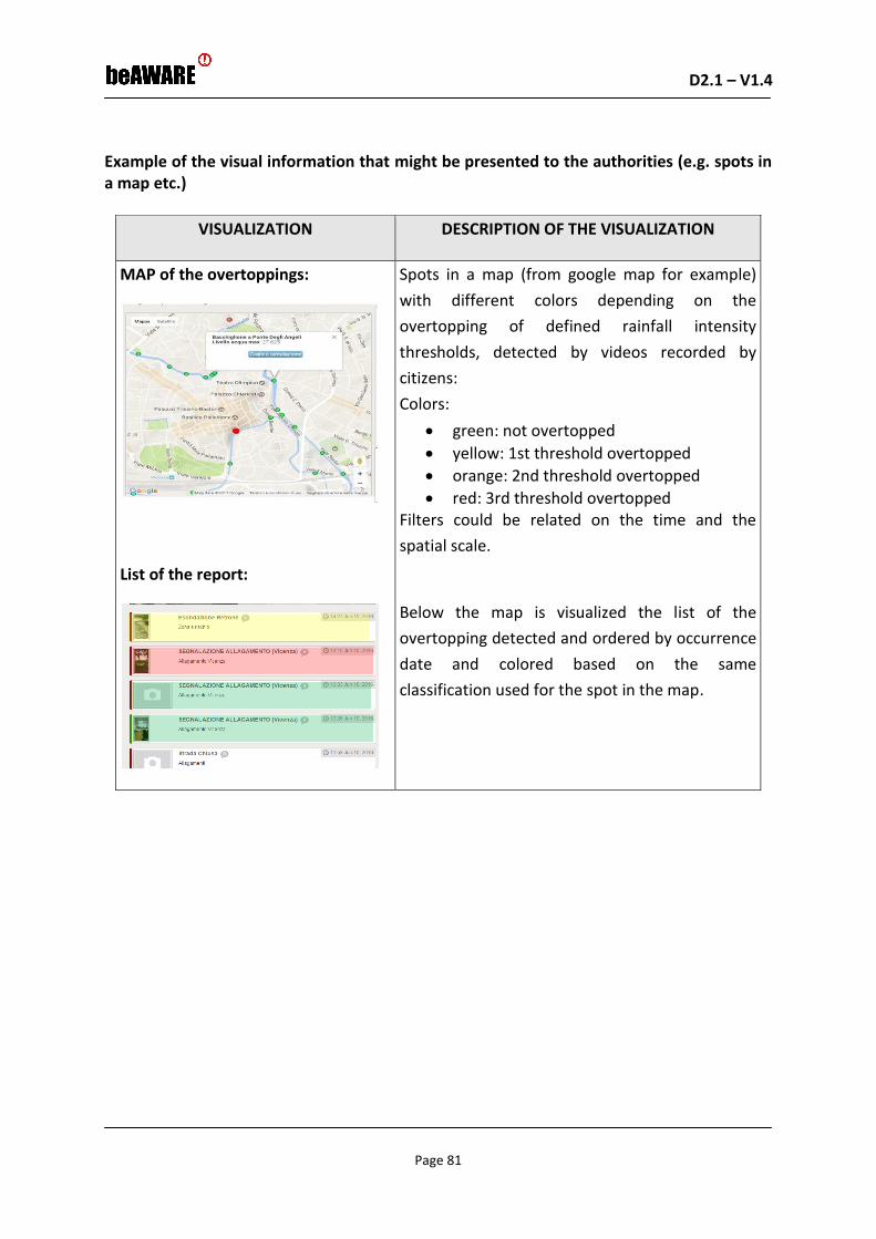
D2.1 – V1.4 D2.1 – V1.0
Page 81
Example of the visual information that might be presented to the authorities (e.g. spots in a map etc.)
VISUALIZATION DESCRIPTION OF THE VISUALIZATION
MAP of the overtoppings:
List of the report:
Spots in a map (from google map for example)
with different colors depending on the
overtopping of defined rainfall intensity
thresholds, detected by videos recorded by
citizens:
Colors:
green: not overtopped
yellow: 1st threshold overtopped
orange: 2nd threshold overtopped
red: 3rd threshold overtopped Filters could be related on the time and the
spatial scale.
Below the map is visualized the list of the
overtopping detected and ordered by occurrence
date and colored based on the same
classification used for the spot in the map.

D2.1 – V1.4 D2.1 – V1.0
Page 82
VISUALIZATION DESCRIPTION OF THE VISUALIZATION
MAP of the assignments:
List of the assignments:
Spots in a map (from google map for example)
with the location of the assignments.
Filters could be related on the subject of the
tasks, the time and the spatial scale.
Below the map the list of the assignments,
filtered and ordered by creation date, is
visualized.
Virtual regions of interest will be defined by the
System, based on the warning received. For
example each message point could be considered
as the center of a circle with a radius of 500 m.
Example of the textual information that might be presented to the authorities
From First Responders
o None
From Citizens
o None
Example of messages that might be presented to the people
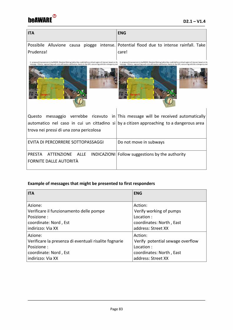
D2.1 – V1.4 D2.1 – V1.0
Page 83
ITA ENG
Possibile Alluvione causa piogge intense.
Prudenza!
Questo messaggio verrebbe ricevuto in
automatico nel caso in cui un cittadino si
trova nei pressi di una zona pericolosa
Potential flood due to intense rainfall. Take
care!
This message will be received automatically
by a citizen approaching to a dangerous area
EVITA DI PERCORRERE SOTTOPASSAGGI Do not move in subways
PRESTA ATTENZIONE ALLE INDICAZIONI
FORNITE DALLE AUTORITÀ
Follow suggestions by the authority
Example of messages that might be presented to first responders
ITA ENG
Azione: Verificare il funzionamento delle pompe Posizione : coordinate: Nord , Est indirizzo: Via XX
Action: Verify working of pumps Location : coordinates: North , East address: Street XX
Azione: Verificare la presenza di eventuali risalite fognarie Posizione : coordinate: Nord , Est indirizzo: Via XX
Action: Verify potential sewage overflow Location : coordinates: North , East address: Street XX

D2.1 – V1.4 D2.1 – V1.0
Page 84
ITA ENG
Azione: Verificare l'eventuale mancanza di alimentazione elettrica Posizione : coordinate: Nord , Est indirizzo: Via XX
Action: Verify potential missing of power supply Location : coordinates: North , East address: Street XX
Example of reports from the first responders that might be presented to the authority
(tasks etc.)
None
The roles under the term authority
Mayor
Mobile application equipment
Personal Mobile Phone
UC_106: Monitoring river breaking/overtopping and assignment of relative tasks
This Use Case concerns the assignment of tasks to first responders based on the monitored
river breaking/overtopping.

D2.1 – V1.4 D2.1 – V1.0
Page 85
Fig. 5-6. Block Diagram of the UC106
Current Status (initial phase of the scenario)
• Before the flood
What is known to the beAWARE system already
• Weather forecast
• Location of the forecasted flooded area
What is happening
• A fixed camera, located in correspondence of a river section of interest, records
continuously water level inside the river and the possible breaking triggering
• Citizens are recording a video about a river embankment
Outcome
• Once the embankment is overtopped or broken the authority (e.g. mayor) assigns
tasks to first responders
• Once the embankment is overtopped or broken the authority (e.g. mayor) sends
notifications to citizens approaching the dangerous areas and suggests alternative
ways
Example of the visual information that might be presented to the authorities (e.g. spots in a map etc.)

D2.1 – V1.4 D2.1 – V1.0
Page 86
VISUALIZATION DESCRIPTION OF THE VISUALIZATION
MAP:
List of the report filtered and ordered by
submission date:
Spots in a map (from google map for
example) with different colors
depending on the status of the
embankment detected by videos
recorded by citizens and the fixed
cameras:
Colors:
grey: not overtopped/broken
yellow: start overtopping/breaking
red: overtopping/breaking in progress
Filters could be related on the time
and the spatial scale and status.
Below the map the list of the report,
filtered and ordered by submission
date, is visualized.
Virtual regions of interest will be defined
by the System, based on the warning
received. For example each message point
could be considered as the center of a
circle with a radius of 500 m.

D2.1 – V1.4 D2.1 – V1.0
Page 87
VISUALIZATION DESCRIPTION OF THE VISUALIZATION
MAP of the assignments:
List of the assignments:
Spots in a map (from google map for example)
with the location of the assignments.
Filters could be related on the subject of the
tasks, the time and the spatial scale.
Below the map the list of the assignments,
filtered and ordered by creation date, is
visualized.
Example of the textual information that might be presented to the authorities
From First Responders
o None
From Citizens
ITA ENG
Stato dell'argine: Normale Commento: Tutto ok
Status of the embankment: not overtopped/broken Comment: All is ok
Stato dell'argine: Innesco rottura/sormonto Commento: Pericolo!! l'acqua comincia ad uscire dall'argine
Status of the embankment: start overtopping/breaking Comment: I need more time
Stato del argine: Rottura/sormonto in corso Commento: Sto scappando! Allontanarsi dalla zona!
Status of the embankment: overtopping/breaking in progress Comment: I am escaping! Leave this place!
Example of messages that might be presented to the people

D2.1 – V1.4 D2.1 – V1.0
Page 88
ITA ENG
Alluvione in corso. Allontanarsi
rapidamente e in sicurezza dalla zona.
Sono stati identificati i seguenti luoghi
sicuri non soggetti ad allagamento o
esondazione:
via Pforzheim - viale Cricoli (park Cricoli)
via Baden Powell (cittadella degli studi)
via Ragazzi del '99 (parcheggio cimitero)
via Trieste (parcheggio viale del Cimitero)
Monte Berico (piazzale della Vittoria) Park Borgo Berga - nuovo tribunale corso SS Felice e Fortunato – via
Cattaneo (park Cattaneo) via Cattaneo - via dei Cairoli (ex
sedime ferroviario) viale Btg. Framarin (parcheggio
Teatro Comunale) via Btg. Framarin – via Cengio via del Mercato Nuovo (parcheggio
mercato ortofrutticolo) via Btg. Val Leogra (park Dogana) viale Ferrarin (parcheggio centro
culturale San Paolo)
Questo messaggio verrebbe ricevuto in
automatico nel caso in cui un cittadino si
trova nei pressi di una zona pericolosa
Flood in progress. Escape rapidly and safely. The
following safe places were identified:
via Pforzheim - viale Cricoli (park Cricoli) via Baden Powell (cittadella degli studi) via Ragazzi del '99 (parcheggio cimitero) via Trieste (parcheggio viale del Cimitero) Monte Berico (piazzale della Vittoria) Park Borgo Berga - nuovo tribunale corso SS Felice e Fortunato – via Cattaneo (park
Cattaneo) via Cattaneo - via dei Cairoli (ex sedime
ferroviario) viale Btg. Framarin (parcheggio Teatro
Comunale) via Btg. Framarin – via Cengio via del Mercato Nuovo (parcheggio mercato
ortofrutticolo) via Btg. Val Leogra (park Dogana)
This message will be received automatically by a
citizen approaching to a dangerous area

D2.1 – V1.4 D2.1 – V1.0
Page 89
ITA ENG
Alluvione in corso. SE NON PUOI ABBANDONARE LA CASA SALI AI PIANI SUPERIORI E ATTENDI L’ARRIVO DEI SOCCORSI.
Flood in progress. If you cannot leave your home, reach the highest floors and wait for the rescue teams
SE SEI IN MACCHINA EVITA DI INTASARE LE STRADE
If you are driving, do not cause traffic jam
NON PERCORRERE STRADE INONDATE E SOTTOPASSAGGI
Do not move in flooded streets and subways
PRESTA ATTENZIONE ALLE INDICAZIONI FORNITE DALLE AUTORITÀ
Take care about suggestions by authority
La distribuzione dei sacchi di sabbia è
disponibile presso le seguenti
postazioni:
Piazza Venti Settembre Ca' Tosate Via del Grande (zona stadio) Viale Ferrarin (lato nord) Piazza Matteotti (vicino
all’ostello della gioventù) San Pietro Intrigogna (piazzale
della chiesa) Viale Fusinato (parcheggio chiesa
San Giorgio) Via Leoni Viale del Brotton/ viale Ferrarin Debba (piazzale della chiesa) Contra' San Pietro (piazzale della
chiesa) Via Sardegna Contra' Santi Apostoli
The distribution of sand packs is available at the
following locations:
Piazza Venti Settembre Ca' Tosate Via del Grande (zona stadio) Viale Ferrarin (lato nord) Piazza Matteotti (vicino all’ostello della
gioventù) San Pietro Intrigogna (piazzale della chiesa) Viale Fusinato (parcheggio chiesa San
Giorgio) Via Leoni Viale del Brotton/ viale Ferrarin Debba (piazzale della chiesa) Contra' San Pietro (piazzale della chiesa) Via Sardegna Contra' Santi Apostoli
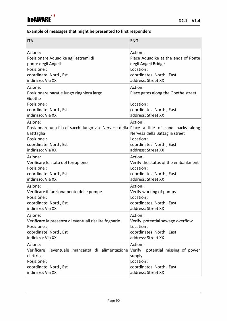
D2.1 – V1.4 D2.1 – V1.0
Page 90
Example of messages that might be presented to first responders
ITA ENG
Azione: Posizionare Aquadike agli estremi di ponte degli Angeli Posizione : coordinate: Nord , Est indirizzo: Via XX
Action: Place Aquadike at the ends of Ponte degli Angeli Bridge Location : coordinates: North , East address: Street XX
Azione: Posizionare paratie lungo ringhiera largo Goethe Posizione : coordinate: Nord , Est indirizzo: Via XX
Action: Place gates along the Goethe street Location : coordinates: North , East address: Street XX
Azione: Posizionare una fila di sacchi lungo via Nervesa della Batttaglia Posizione : coordinate: Nord , Est indirizzo: Via XX
Action: Place a line of sand packs along Nervesa della Battaglia street Location : coordinates: North , East address: Street XX
Azione: Verificare lo stato del terrapieno Posizione : coordinate: Nord , Est indirizzo: Via XX
Action: Verify the status of the embankment Location : coordinates: North , East address: Street XX
Azione: Verificare il funzionamento delle pompe Posizione : coordinate: Nord , Est indirizzo: Via XX
Action: Verify working of pumps Location : coordinates: North , East address: Street XX
Azione: Verificare la presenza di eventuali risalite fognarie Posizione : coordinate: Nord , Est indirizzo: Via XX
Action: Verify potential sewage overflow Location : coordinates: North , East address: Street XX
Azione: Verificare l'eventuale mancanza di alimentazione elettrica Posizione : coordinate: Nord , Est indirizzo: Via XX
Action: Verify potential missing of power supply Location : coordinates: North , East address: Street XX

D2.1 – V1.4 D2.1 – V1.0
Page 91
Example of reports from the first responders that might be presented to the authority
(tasks etc.)
None
The roles under the term authority
Mayor
Mobile application equipment
Personal Smartphones with Android or Windows or IoS Operating System installed
QUERY TO THE PSAP
UC_107: First responders monitoring
This Use Case concerns a possible query to the PSAP to monitor first responders activities.
Fig. 5-7. Block Diagram of the UC107

D2.1 – V1.4 D2.1 – V1.0
Page 92
Current Status (initial phase of the scenario)
• During a flood event
What is happening
• First responders are performing the tasks assigned by the authority. Some of them
were not able to complete the task.
Outcome
• The Mayor can visualize the assigned tasks to first responders and their execution
state
• The Mayor can send warnings to available rescue teams to help colleagues not able
to complete the assignment
• The Mayor can send warnings to citizens in order to avoid interferences inside the
area involved by civil protection activities
UC_108: Flood forecasting alerts
This Use Case concerns a possible query to the PSAP to detect possible future forecasted
flood events.
Fig. 5-8. Block Diagram of the UC108
Current Status (initial phase of the scenario)
• Before a flood event
What is happening

D2.1 – V1.4 D2.1 – V1.0
Page 93
• Intense rainfall event is forecasted
Outcome
• The Mayor can visualize if there are overtopping of alert thresholds in the modeled
river cross sections
• Warnings are sent automatically to the authority concerning potential alerts
5.2 Use Cases for the Fire scenario
UC_201: Management of forest fires emergencies
This use case involves all the phases related to a forest fire once it has started.
Fig. 5-9. Block Diagram of the UC201
Current Status
• During the forest fire
What is known to the beAWARE system already
• Weather forecast
• Level of the forest fire crisis
• Location of the forest fire
What is happening
• A first responder is sending images/videos/text

D2.1 – V1.4 D2.1 – V1.0
Page 94
• Inputs from cameras and weather data
• Tweets are mentioning forest fire emergency
• Citizens are sending reports on forest fires with images, videos and text
Outcome
• The authority (e.g. Mayor) move forces to the new location
• The authority mobilize more or new resources (e.g. planes or helicopters)
• The authority sends notifications to citizens approaching the dangerous areas and
suggests alternative ways
• The authority points safe ways and places, sends recommendations and even
organizes evacuations.
Example of the visual information that might be presented to the authorities (e.g. spots in a map etc.)
Fig. 5-10. PSAP visualization of resources and requirements at PLV
Video Wall that shows a map of the city with:
o Location of Police patrols in the map displaying them with different
geometrical shapes and colours according to the police tasks.
o Location of the cranes.
o Location of the incidents displaying them in the map-video Wall according to
their level of gravity.
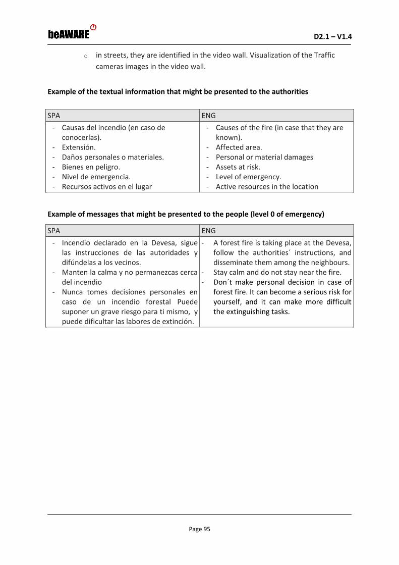
D2.1 – V1.4 D2.1 – V1.0
Page 95
o in streets, they are identified in the video wall. Visualization of the Traffic
cameras images in the video wall.
Example of the textual information that might be presented to the authorities
SPA ENG
- Causas del incendio (en caso de conocerlas).
- Extensión. - Daños personales o materiales. - Bienes en peligro. - Nivel de emergencia. - Recursos activos en el lugar
- Causes of the fire (in case that they are known).
- Affected area. - Personal or material damages - Assets at risk. - Level of emergency. - Active resources in the location
Example of messages that might be presented to the people (level 0 of emergency)
SPA ENG
- Incendio declarado en la Devesa, sigue las instrucciones de las autoridades y difúndelas a los vecinos.
- Manten la calma y no permanezcas cerca del incendio
- Nunca tomes decisiones personales en caso de un incendio forestal Puede suponer un grave riesgo para ti mismo, y puede dificultar las labores de extinción.
- A forest fire is taking place at the Devesa, follow the authorities´ instructions, and disseminate them among the neighbours.
- Stay calm and do not stay near the fire. - Don´t make personal decision in case of
forest fire. It can become a serious risk for yourself, and it can make more difficult the extinguishing tasks.

D2.1 – V1.4 D2.1 – V1.0
Page 96
Example of messages that might be presented to the people (level 1 of emergency)
SPA ENG
- En caso de incendio forestal, cuando salgas, por favor cierra la puerta y las ventanas. No olvides cortar la luz.
- Nunca tomes decisiones personales en caso de un incendio forestal Puede suponer un grave riesgo para ti mismo, y puede dificultar las labores de extinción. Ten siempre preparadas o fácilmente localizables las cosas que consideres más importantes.
- No arriesgues tu vida por salvar objetos personales.
- Evita acercarte a la Devesa, toma rutas alternativas
- In case of forest fire when you go out, please close the door and the windows and remember to cut the electricity.
- Don´t make personal decision in case of forest fire. It can become a serious risk for yourself, and it can make more difficult the extinguishing tasks. Your most important things must be easily located and always ready.
- Don´t risk your life to save personal objects!
- Avoid approaching to the Devesa, take alternative routes.
Example of messages that might be presented to first responders
(TRANSCRIPTION OF COMMUNICATIONS BETWEEN PSAP/CISE AND FIRST RESPONDERS
DURING A FOREST FIRE IN “LA DEVESA”)
SPA ENG
12:10
POLO (PLV PSAP): Lince-50 aquí Polo
LINCE-50: Adelante
POLO: Diríjase al restaurante La Duna, desde allí están viendo una columna de humo próxima al cortafuegos de la Rambla, Bomberos se dirige.
LINCE-50: Recibido Polo, nos encontramos cerca, ahora le informo.
12:10
POLO(PLV PSAP): Lynx-50 here Polo
LYNX-50: Forward POLO
POLO: Go to the restaurant La Duna, from there citizens are looking at a smoke column next to the firebreak of the Rambla, Firefighters are on their way.
LYNX-50: Polo, roger. We are close, we will inform to you in a bit.

D2.1 – V1.4 D2.1 – V1.0
Page 97
SPA ENG
12:18
LINCE-50: Polo, llegada de LINCE-50. El incendio todavía no es muy grande pero se puede descontrolar rápidamente, el viento sopla con fuerza. Indique a bomberos que entrando por el cortafuego de la Rambla se accede bien a la cabeza del incendio.
POLO: Recibido
LINCE 50: Polo, de momento se está quemando pasto y matorral, se habrán quemado unos 20 metros cuadrados, el frente principal ya tiene aproximadamente 4 metros de longitud, y se dirige hacia la pinada.
12:18
LYNX-50: Polo, arrival of Lynx-50. The fire is still not very big but it may be quickly uncontrolled, the wind blows hard. Tell Firefighters that entering through the Rambla firewall they would access well to the head of the fire.
POLO: Roger
LYNX-50: Polo, it is burning grass and scrub at the moment, there are burned about 20 square meters so far, the main front already has approximately 4 meters in length, and is being directed towards the pinnacle.
12:22
LINCE 50: Polo llegada de bomberos, ahora le indico los indicativos.
LINCE-50: Se han personado dos unidades, el BUP-3 y el BUL-1.
POLO: Recibido. A partir de este momento, por favor compañeros céntrense en controlar los accesos al camino donde se colocan los vehículos Autobombas, cortándolos totalmente si fuera necesario para facilitar el tránsito a los vehículos de extinción de incendios y de asistencia sanitaria. Todas las comunicaciones respecto a la evolución del incendio o posible necesidad de más medios de extinción, las hará el mando de bomberos presente en la zona.
12:22
LYNX-50: Polo, firefighters have arrived, in a bit I will indicate the unit name.
LYNX-50: There have been two units, the BUP-3 and the BUL-1.
POLO: Roger. From this moment, please stick to the accessing control to the road where the pumping vehicles are parked, cutting them completely if necessary to facilitate the transit of fire-fighting and assistance vehicles. All communications regarding the evolution of the fire or possible need of more resources for the fire extinction will be made by the Firefighters head present in the area.

D2.1 – V1.4 D2.1 – V1.0
Page 98
SPA ENG
12:36
LINCE-50: POLO aquí LINCE-50
POLO: Adelante
LINCE-50: Los bomberos se encuentran en estos momentos evaluando todo el perímetro y apagando todos los rescoldos que queden encendidos, para evitar posibles reproducciones/activación del incendio.
LINCE-50: En estos momentos los bomberos ya han controlado el incendio, prácticamente ya no se ven llamas, y van a iniciar las labores de remate y liquidación.
POLO: Recibido
LINCE -50: Bomberos hasta finalizado su labor dando por extinguido el incendio. No obstante, el cabo de bomberos ha decidido que la unidad de extinción permanezca en la zona durante unas horas en prevención debido al nivel 3 de preemergencia y a que el tipo de vegetación en la zona que puede reavivar el incendio, hasta que llegue la noche y/o disminuya en viento. Todo en función de la superficie afectada, tipo de vegetación o climatología).
12:36
LYNX-50: Polo here Lince-50
POLO: Forward
LYNX-50: Firefighters are currently evaluating the entire perimeter and extinguishing all the embers that remain lit to avoid possible reproductions / activation of the fire. Firefighters have already controlled the fire, which is no longer visible, and they are going to start the total extinction and liquidation.
POLO: Roger
LYNX-50: Firefighters have finished their work considering the fire extinguished.
However, the fire department has decided that the extinction unit stays in the area preventively for a few hours due to pre-emergence level 3 and the type of vegetation in the area, that could revive the fire. They will stay until nightfall and /or the pre-emergency level goes down. All depending on the area affected, type of vegetation or climatology.
13:29
POLO: LINCE-50 aquí POLO podría indicarme qué tipo de superficie se ha quemado y el tamaño de la misma
LINCE 50: El combustible quemado es pastizal y matorral formado principalmente por coscoja y lentisco. Según indica el cabo de bomberos, la superficie afectada es de unos 500 metros cuadrados.
POLO: Recibido
13:29
POLO: LYNX-50 here Polo. Could you tell me what type of surface has been burned and the size of it?
LYNX-50: Burned fuel is grassland and shrub mainly formed by shrub oak and mastic shrub. According to the fire department, the affected area is about 500 square meters.
POLO: Roger

D2.1 – V1.4 D2.1 – V1.0
Page 99
SPA ENG
13:35
LINCE 50: POLO cierre el servicio del incendio de La Devesa de El Saler, los bomberos abandonan el lugar y nosotros también, dejando un vehículo de extinción en funciones de vigilancia del área quemada hasta que mejorar las condiciones climatológicas o baje el nivel de preemergencia.
A continuación procederemos a realizar un informe policial con los datos del incendio, mencionando sus posibles causas.
13:35
LYNX-50: Polo, close the fire service of La Devesa de El Saler, Firefighters leave the place and so do we, leaving an extinction vehicle in surveillance functions around the burned area until conditions are improved or the level of pre-emergence goes down.
We will proceed to carry out a police report with the data of the fire, mentioning its possible causes.
Example of reports from the first responders that might be presented to the authority
(tasks etc.)
SPA ENG
- Daños personales o materiales. - Superficie afectada por el incendio
forestal. - Incendio forestal intencionado, natural o
accidental. - Predicción del comportamiento del fuego
(en función de las condiciones climatológicas, la vegetación y la topografía).
- Recursos activos en el lugar
- Personal damages or material damages - Affected surface by the forest fire - intentional, natural or accidental forest
fire - Fire behavior forecast (depending on
weather conditions, growth and topography).
- Active resources in the location
The roles under the term authority
The highest rank authority in case of metropolitan fire events is the Mayor unless the fire
extends to another municipality, or external resources from this municipality are needed. If
so, the authority is the highest rank person in service in the General Directorate for
Emergencies of the Civil Protection in the Valencian Community (Valencian Region). In case
that the fire requires external resources from the Valencian Community, that the fire
trespasses into another community, or that it reaches national interest due to its gravity or
potential risks, the Emergencies Coordination Center from the Valencian Community will
warn to the Interior Minister, who will be the highest authority.

D2.1 – V1.4 D2.1 – V1.0
Page 100
Mobile application
There is no mobile application currently available in Valencia, dealing with warnings and/or
service requirements to the PSAP.
UC_202: Activation of first responders
This use case concerns the process of activation of first responders from the fire is detected
to the first responders receive their tasks. It shows the use of the mobile application as a
tool to provide to the Be@ware system with input data, as well as the order in which a
decision for the activation of first responders has been made.
Fig. 5-11. Block Diagram of the UC202
Current status (initial phase of the scenario)
• Before the fire
What is known to the beAWARE system already
• Weather forecast
• Drought index
• Available resources
• Access road
What is happening

D2.1 – V1.4 D2.1 – V1.0
Page 101
• A citizen spots the fire and alerts by using mobile application. This makes it possible
to locate the position in the forest by GPS.
Outcome
• By reporting the fire incident, the authorities are alerted and the available resources
and first responders are assigned.
Example of the visual information that might be presented to the authorities (e.g. spots in a map etc.)
Fig. 5-12. PSAP visualization of resources and requirements at PLV
Video material from the thermal/fixed cameras system.
GIS (geographic information system) of the area

D2.1 – V1.4 D2.1 – V1.0
Page 102
Example of the textual information that might be presented to the authorities
DEN ENG
Brandens placering: En brand er blevet spottet på X placering (GPS koordinater hvis det er muligt). Brandens spredning: Branden har bredt sig over X kvm (hvis den viden er kendt). Tilgængelige ressourcer: X køretøjer fra de relevante aktører vil blive sendt til hændelsens placering. Adgangsveje: Branden kan tilgås via X vej eller alternativt Y vej, alt efter vejrforholdene. Mennesker eller bygninger i fare: I fareområdet er X antal personer og Y antal vigtige bygninger.
Location of the fire: A fire has been spotted in X location (GPS coordinates if possible). The spread of the fire: The fire is covering X square miles (if known). Available resources: X vehicles from the relevant authorities will be sent to the location. Access roads: The fire can be reached by X road or alternatively Y road depending on the weather conditions. People or buildings at risk: In the risk area are X residents and Y important buildings.
Example of messages that might be presented to the people
None
Example of messages that might be presented to first responders
DEN ENG
Vær opmærksom på vindretningen og tilgå branden fra modsatte side. X antal brandkøretøjer og brandfolk er blevet indsat til hændelsen. Være opmærksom på personer der bor eller vandrer i området. Husk at bære korrekt beskyttelsesudstyr. Hav sikre evakueringsruter klar i tilfælde af det bliver nødvendigt.
Be aware of the wind direction and approach the fire from opposite direction. X number of firetrucks and firefighters have been sent to the incident. Be aware of people living or hiking in the area. Remember to wear personnel protection gear. Have safe evacuation roads ready in case they are needed.

D2.1 – V1.4 D2.1 – V1.0
Page 103
Example of reports from the first responders that might be presented to the authority
(tasks etc.)
DEN ENG
Berørt område og brandens spredning: Branden er i X område og har spredt sig til X kvm. Forudsigelse af brandens adfærd (afhængig af vejrforhold, bevoksning og typografi): Vi forudser at branden vil bevæge sig i X retning og med Y fart. Skade på indsatspersonel eller materialer (hvis det er tilfældet). Indsatspersonel og køretøjer indsat: X antal brandkøretøjer og brandfolk er indsat i brandslukningsarbejdet.
Affected area and spreading of the fire: The fire is in X area and has spread to X square miles. Fire behavior forecast (depending on weather
conditions, growth and topography): We
predict the fire will move in X direction and
with Y speed.
Personnel damage or material damage (in case any). Personnel and vehicles active: X number of firetrucks and personnel is fighting the fire.
The roles under the term authority
The PSAP will have the incoming call regarding the detection of the fire and will dispatch the
relevant authorities.
The incident will primarily involve the fire department, health organizations and the police.
Other relevant authorities might be involved, especially in case of evacuation. Health care
can be involved in relation to evacuation of elderly or people with disabilities, because they
know where they are located and what special precautions you need to take and be aware
of.
The police have the final decision authority in this case, but in close cooperation with the fire
department. The police and relevant authorities will gather at a local coordination point to
work close together and coordinate the incident at management level.
Mobile application equipment
In Denmark, there is a mobile application that you can use for calling the emergency
services, PSAP, on 112. When you call the authorities through this app, your GPS location will
be sent to the PSAP, so they can locate where you are. It is very useful when the caller is in a
rural area or don’t know their exact location. The caller just pushes the button saying call
112 (RING 1-1-2) and then the application will make the call for them.

D2.1 – V1.4 D2.1 – V1.0
Page 104
Example of how this application looks:
Fig. 5-13. The Danish 112 application for mobile phone
UC_203: Pre-emergency level 3 activation
This use case concerns the activation of pre-emergency level 3. In this case, all resources are
mobilized in order to perform dissuasive surveillance in sensible areas and the population
must be advised so that they extreme cautions
Fig. 5-14. Block Diagram of the UC203

D2.1 – V1.4 D2.1 – V1.0
Page 105
Current status (initial phase of the scenario)
• There is no fire, and the BeAWARE system is analysing different inputs
What is known to the beAWARE system already
• It has already received input from weather forecast, and (if available) from fixed
cameras, drones and mobile application users.
What is happening
• The BeAWARE system is analysing the convenience of activation of the pre-
emergency level 3. This level considers the risk of wildfire as extreme. In addition to
the resources mobilized in Level 2, it will also mobilize the Guardia Civil, Autonomic
Police, municipalities, brigades.
Outcome
• The BeAWARE system sees the convenience of establishing level 3 pre-emergency,
therefore it informs to the PSAP, and send automatic messages to the people
through mobile app.
Example of the visual information that might be presented to the authorities (e.g. spots in a map etc.)
Fig. 5-15. PSAP visualization of resources and requirements at PLV
Video Wall that shows a map of the city with:
o Location of Police patrol in the map and display of them with different
geometrical shapes and colours according to the police tasks.
o Location of the cranes.

D2.1 – V1.4 D2.1 – V1.0
Page 106
o Location of the incidents and display of them in the map-video Wall according
to their seriousness.
o Traffic cameras in streets, they are identified in the video wall. Visualization
of the images in the video wall.
Example of the textual information that might be presented to the authorities
SPA ENG
- Condiciones meteorológicas (temperatura, humedad, dirección y fuerza del viento)
- Nivel de pre-emergencia. - Recursos operativos en el lugar. - Bienes y personas en riesgo. - Información sobre estado de las vías de
acceso y evacuación.
- Weather conditions (temperature, humidity, wind direction and speed)
- Pre-emergency level. - Operative resources in the area. - People and assets at risk. - Level of emergency. - Information about access and evacuation
roads status.
Example of messages that might be presented to the people (at a level 3 of pre-
emergency)
SPA ENG
- Aviso de alerta 3 de riesgo de incendio extremo.
- Prohibido encender fuego y el uso de camping-gas o similares en todo el área de la Devesa.
- Prohibido el uso de artificios pirotécnicos.
- Estacione su vehículo de forma adecuada, sin cortar vías de acceso y evacuación.
- Prohibido arrojar basuras fuera de las zonas habilitadas.
- Prohibida la acampada en toda el área de La Devesa.
- Warning of extreme risk of forest fire. - It is forbidden to light a fire and any usage
of camping-gas or similar artifacts. - It is forbidden the use of pyrotechnic
devices. - Park your vehicle properly, without
cutting access and/or evacuation routes. - Throwing litter in unauthorized areas is
forbidden. - Camping in the whole area of La Devesa is
forbidden.
Example of messages that might be presented to the first responders
None

D2.1 – V1.4 D2.1 – V1.0
Page 107
We have to bear in mind that some behaviours that are permitted in lower pre-emergency
levels may be forbidden during pre-emergency level 3. On the other hand, the use of
pictograms in information panels could be convenient to reinforce effective communication.
Finally, indicating the amount of the fine in case of breach can help to deter any undesired
behaviour.
Example of reports from the first responders that might be presented to the authority
(tasks etc.)
None
The roles under the term authority
Once level 3 pre-emergency level notification is received through the autonomic
Command Control emergency coordination center (CCE) the Mayor, as Civil
Protection Chief of the municipality of Valencia, will mobilize the resources in order
to set vigilance services in the most sensitive areas. Firefighters Command Control
Centre (CECOM) will warn not only their own resources, but also the rest of
municipal resources.
Besides this, the Mayor will issue a proclamation in which this situation is notified,
indicating that pre-emergency level 3 (extreme) has been established, and warning
that compulsory preventive measures referred to in Decree 98/1995, of May 16
should be taken into account. Among these, any fire authorization previously done is
cancelled, and circulation of people and/or vehicles may be restricted. Any work or
activity that can constitute a risk may be suspended as well.
Mobile application equipment
Nowadays there is no mobile app warning of these emergencies. However, there are
some active Twitter accounts in which organizations share this information, for
instance: PLV official Twitter @policialocalvalencia (15.000 followers), Spanish
Meteorological Agency @AEMET_Esp (114.000 followers), and Emergencies
Command Control of Comunidad Valenciana @GVA112 (68.000 followers).
UC_204: Evacuation management during an emergency
This use case concerns the evacuation management during a forest fire. In case of
population at risk, the authority will order the evacuation and first responders will be given
instructions to facilitate the evacuation.

D2.1 – V1.4 D2.1 – V1.0
Page 108
Fig. 5-16. Block Diagram of the UC204
Current status (initial phase of the scenario)
• During a forest fire
What is known to the beAWARE system already
• Weather forecast
• Location and direction of the fire
• Location of citizens at risk
• Location of first responders
• Road status and secure places locations.
What is happening
• Citizens are sending text, video and images of a forest fire going towards a residential
area or public attendance place. Aerial video and images are being sended as well.
Outcome
• The authority informs citizens of evacuation order and the PSAP gives instructions to
first responders in order to facilitate the evacuation
Example of the visual information that might be presented to the authorities (e.g. spots in a map etc.)

D2.1 – V1.4 D2.1 – V1.0
Page 109
Fig. 5-17. PSAP visualization of resources and requirements at PLV
Video Wall that shows a map of the city with:
o Location of Police patrol in the map and display of them with different
geometrical shapes and colours according to the police tasks.
o Location of the cranes.
o Location of the incidents and display of them in the map-video Wall according
to their seriousness.
o Traffic cameras in streets, they are identified in the video wall. Visualization
of the images in the video wall.
Example of the textual information that might be presented to the authorities
SPA ENG
- Causas del incendio (en caso de conocerlas).
- Extensión. - Daños personales o materiales. - Bienes en peligro. - Nivel de emergencia. - Recursos activos en el lugar - Información sobre estado de las vías de
acceso y evacuación.
Causes of the fire (in case that they are known). Extension. Personal or material damages Assets at risk. Level of emergency. Active resources in the location. Information about access and evacuation roads status.
Example of messages that might be presented to the people (in evacuation management)
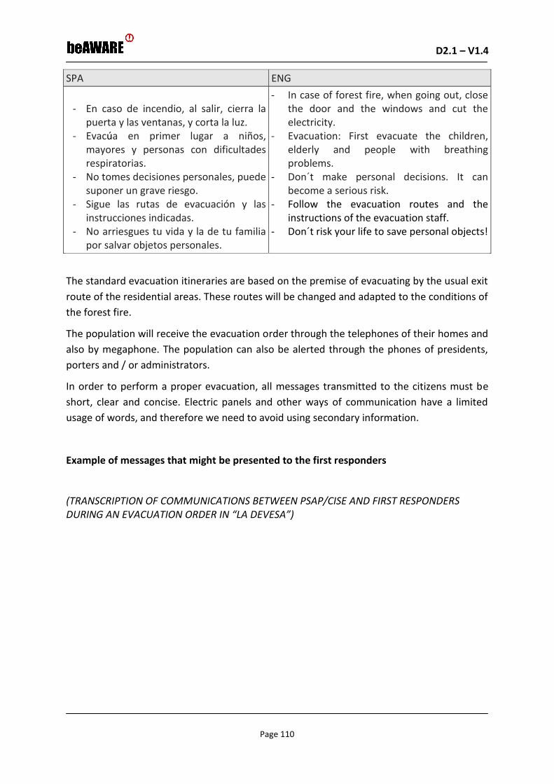
D2.1 – V1.4 D2.1 – V1.0
Page 110
SPA ENG
- En caso de incendio, al salir, cierra la
puerta y las ventanas, y corta la luz. - Evacúa en primer lugar a niños,
mayores y personas con dificultades respiratorias.
- No tomes decisiones personales, puede suponer un grave riesgo.
- Sigue las rutas de evacuación y las instrucciones indicadas.
- No arriesgues tu vida y la de tu familia por salvar objetos personales.
- In case of forest fire, when going out, close the door and the windows and cut the electricity.
- Evacuation: First evacuate the children, elderly and people with breathing problems.
- Don´t make personal decisions. It can become a serious risk.
- Follow the evacuation routes and the instructions of the evacuation staff.
- Don´t risk your life to save personal objects!
The standard evacuation itineraries are based on the premise of evacuating by the usual exit
route of the residential areas. These routes will be changed and adapted to the conditions of
the forest fire.
The population will receive the evacuation order through the telephones of their homes and
also by megaphone. The population can also be alerted through the phones of presidents,
porters and / or administrators.
In order to perform a proper evacuation, all messages transmitted to the citizens must be
short, clear and concise. Electric panels and other ways of communication have a limited
usage of words, and therefore we need to avoid using secondary information.
Example of messages that might be presented to the first responders
(TRANSCRIPTION OF COMMUNICATIONS BETWEEN PSAP/CISE AND FIRST RESPONDERS DURING AN EVACUATION ORDER IN “LA DEVESA”)

D2.1 – V1.4 D2.1 – V1.0
Page 111
SPA ENG
12:10
POLO (PLV PSAP): Lince-30 aquí Polo
LINCE-30: Adelante
POLO: Por orden del P.M.A. se ordena la evacuación de la zona residencial de La Devesa y la Playa de la Garrofera. La vía de evacuación es Av. Gola de Pujol dirección centro de ciudad. Ordene las medidas necesarias.
LINCE-30: Recibido Polo.
LINCE-30: Lince-50, acudan a las dos vías de salida de la urbanización, y facilite el tráfico en dirección centro de ciudad.
LINCE 50: Recibido.
LINCE 30: Lince 51, diríjase a playa La Garrofera y proceda a su evacuación en dirección Av. Gola de Pujol.
LINCE 51: Recibido.
LINCE 30: Lince 52, acceda al interior de la urbanización Casbah y de las instrucciones para su evacuación.
LINCE 52: Recibido.
LINCE 30: Lince 53, diríjase a la AV. Gola de Pujol, frente al hotel Sidi Saler y facilite la evacuación en dirección al tallafoc de Pujol.
LINCE 53: Recibido.
LINCE 30: Lince 54, acuda a la Av. Gola de Pujol cruce con el Tallafoc de Pujol (junto al edificio Siena). Facilite salida dirección Av. De los Pinares.
LINCE 54: Recibido.
LINCE 30: Lince 55, acuda a Av. Gola de Pujol con Tallafoc de La Garrofera, en prevención junto al vial cortado.
LINCE 55: Recibido.
POLO: A todas las unidades, el punto de encuentro y de información para los evacuados es en los Viveros Municipales de Av. De los Pinares. Confirmen el recibido.
…
12:10
POLO/(PLV PSAP): Lynx-50 here Polo
LYNX-50: Forward POLO
POLO/: By Incident Commander´s order, Casbah residential area and La Garrofera beach must be evacuated. Evacuation way is Gola de Pujol Avenue towards city centre. Order the necessary measures.
LYNX-30: Polo, roger
LYNX-30: Lince-50, go to the two exit ways of the residential area, and facilitate the traffic in direction to city center
POLO: Roger
LYNX-30: Lince 51, go to La Garrofera beach and proceed to its evacuation towards Gola de Pujol Avenue.
LYNX-51: Roger
LYNX-30: Lince 52, enter inside the Casbah residential area and give instructions for its evacuation.
LYNX-52: Roger.
LYNX-30: Lynx 53, go to Gola de Pujol Avenue, in front of Sidi Saler hotel, and facilitate the evacuation towards tallafoc of Pujol.
LYNX-53: Roger.
LINCE 30: Lince 54, go to Av. Gola de Pujol intersection with Tallafoc de Pujol (next to the Siena building). Provide exit towards Av. De los Pinares.
LYNX-54: Roger.
LYNX-30: Lince 55, go to Av. Gola de Pujol with Tallafoc of La Garrofera, stay there in prevention, next to the cut vial.
LYNX-55: Roger.
POLO: To all units, the meeting and information point for the evacuees is in the Municipal Nurseries of Av. De los Pinares. Confirm received.
...

D2.1 – V1.4 D2.1 – V1.0
Page 112
SPA ENG
LINCE 30: Recibido.
LINCE 50: Recibido.
LINCE 51: Recibido.
LINCE 52: Recibido.
LINCE 53: Recibido.
LINCE 54: Recibido.
LINCE 55: Recibido.
POLO: Lince 40, acuda a los Viveros Municipales para coordinar la actuación en el lugar.
LINCE 40: Recibido.
LINCE-30: Polo, aquí Lince 30.
POLO: Adelante.
LINCE-30: Confirme que la Guardia Civil ha establecido recursos en la Av. De los Pinares.
POLO: Recibido.
LINCE 30: Lince 50, 51 y 52, informen puntualmente del desarrollo de la evacuación, Lince 30 se dirige a ese punto.
LINCE 30: Roger.
LINCE 50: Roger.
LINCE 51: Roger.
LINCE 52: Roger.
LINCE 53: Roger.
LINCE 54: Roger.
LINCE 55: Roger.
POLO: Lince 40, go to the Municipal Nurseries to coordinate the action in the place.
LINCE 40: Roger.
LYNCE-30: Polo, here Lince 30.
POLO: Forward.
LYNX-30: Confirm that the Civil Guard has established resources at Av. De los Pinares.
POLO: Roger.
LYNX 30: Lince 50, 51 and 52, report promptly the development of the evacuation, Lynx 30 is going to that point.
12:40
LINCE 30: Polo, aquí Lince 30.
POLO: Adelante.
LINCE 30: Completada la evacuación de la playa y de la urbanización, sin incidentes. Permanecemos en los puntos a la espera de instrucciones.
POLO: Recibido.
12:40
LYNX 30: Polo, here Lince 30.
POLO: Forward.
LYNX 30: Evacuation of the beach and urbanization completed, without incidents. We remain at the points waiting for instructions.
POLO: Roger.
We have to take into account several aspects:
In these transcribed communications, Lince 30 represents a high-level commander into the
organization (their rank is Inspector). Lince 40 is a medium-level commander (Official), and
the rest of resources mentioned are Officers.
The emergency must be worked through a specific channel, avoiding other resources to use
the same channel. We already have availability of approximately 20 different channels.
All messages should have a maximum length of 20 seconds, as the communication system
does not allow longer messages.
We have to assure that crucial communications have been correctly received by the
resources, as La Devesa presents some dark spots where emissions may be lost.

D2.1 – V1.4 D2.1 – V1.0
Page 113
Example of reports from the first responders that might be presented to the authority
(tasks etc.)
SPA ENG
- Daños personales o materiales. - Incidentes durante la evacuación (si los
ha habido). - Número aproximado de personas
evacuadas. - Predicción del comportamiento del fuego
(en función de las condiciones climatológicas, la vegetación y la topografía).
- Recursos activos en el lugar - Información sobre el estado de las vías
de evacuación.
- Personal damages or material damages - Affected surface by the forest fire - intentional, natural or accidental forest
fire - Fire behavior forecast (depending on
weather conditions, growth and topography).
- Active resources in the location
The roles under the term authority
The fire command responsible for the Advanced Command Post will be the one who orders
the evacuation.
Mobile application
There is no mobile application currently available in Valencia, regarding the warnings and/or
service requirements to the PSAP.

D2.1 – V1.4 D2.1 – V1.0
Page 114
5.3 Use Cases from Heatwave scenario
UC_301: Heatwave forecasting alert
This Use Case concerns the declaration of an “ALERT” before an imminent heatwave and the
continuous monitoring of the forecasted weather conditions.
Fig. 5-18. Block Diagram of the UC301
Current Status (initial phase of the scenario)
• Before a heatwave event
What is happening
• Extreme temperatures are forecasted (heatwave)

D2.1 – V1.4 D2.1 – V1.0
Page 115
Outcome
• The authorities can visualize if there is an imminent heatwave and an alert is issued
through the system
• The system shows the affected area and the forecasted duration of the event
• Warnings are sent automatically to the authority concerning potential alerts
Fig. 5-19. Heat Index Table
7
Note: 40 – 45: Increased sense of discomfort, avoid getting tired; 46 – 53: Severe danger, avoid any activity; > 54: Extreme
danger for health problems (possible heart attack)
Example of the visual information that might be presented to the authorities (e.g. spots in a map etc.)
The system should show that a heatwave is imminent along with an estimate of its
duration and the possible affected area.
Example of the textual information that might be presented to the authorities
From First Responders
o None
7 http://www.eurometeo.com/english/read/doc_heat

D2.1 – V1.4 D2.1 – V1.0
Page 116
From Citizens
o None
Example of messages that might be presented to the people
None
Example of messages that might be presented to first responders
None
Example of reports from the first responders that might be presented to the authority
(tasks etc.)
None
The roles under the term authority
PSAP, Municipalitites, Civil Protection, Fire Department, Hospitals
Mobile application equipment
None
UC_302: Heatwave fire risk assessment
This Use Case concerns the calculation of risk for a forest fire to start as a result of a
heatwave, based on the forecasted weather conditions during and after the period of the
heatwave.
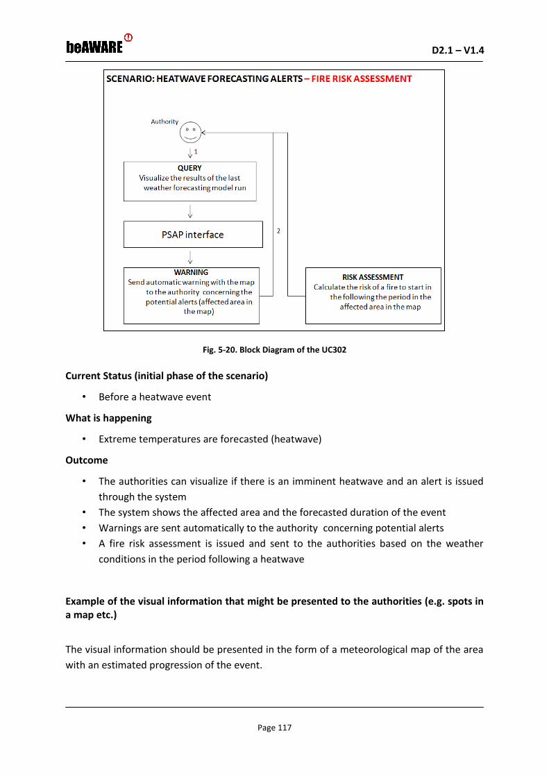
D2.1 – V1.4 D2.1 – V1.0
Page 117
Fig. 5-20. Block Diagram of the UC302
Current Status (initial phase of the scenario)
• Before a heatwave event
What is happening
• Extreme temperatures are forecasted (heatwave)
Outcome
• The authorities can visualize if there is an imminent heatwave and an alert is issued
through the system
• The system shows the affected area and the forecasted duration of the event
• Warnings are sent automatically to the authority concerning potential alerts
• A fire risk assessment is issued and sent to the authorities based on the weather
conditions in the period following a heatwave
Example of the visual information that might be presented to the authorities (e.g. spots in a map etc.)
The visual information should be presented in the form of a meteorological map of the area
with an estimated progression of the event.

D2.1 – V1.4 D2.1 – V1.0
Page 118
In terms of the calsulation of the fire risk assessment, the system should present a
classification of the probability of fire exposure in the next 10 days, as shown in the fig. 5-21
below.
1. LOW
2. MEDIUM
3. HIGH
4. VERY HIGH
5. STATE OF ALERT
Fig. 5-21. Danger levels for fire exposure8
It is the same as the Civil Protection uses currently BUT it will refer in a more local level
Example of the textual information that might be presented to the authorities
From First Responders
o None
From Citizens
o None
Example of messages that might be presented to the people
None
Example of messages that might be presented to first responders
None
Example of reports from the first responders that might be presented to the authority
(tasks etc.)
None
The roles under the term authority
Civil Protection
Fire Department
8 http://civilprotection.gr/el/δασικές-πυρκαγιές

D2.1 – V1.4 D2.1 – V1.0
Page 119
Mobile application equipment
None
UC_303: First Responder Management
This Use Case concerns a possible query to the PSAP to monitor first responders’ activities.
Fig. 5-22. Block Diagram of the UC303
Current Status (initial phase of the scenario)
• During a heatwave event
What is happening
• First responders are performing the tasks assigned by the authorities. Some of them
were not able to complete the task or require further assistance.
Outcome
• The authorities can visualize the assigned tasks to first responders and their
execution state
• The authorities can send warnings to available rescue teams to help colleagues not
able to complete the assignment or require further assistance.
• The Mayor can send warnings to citizens in order to take some proactive actions /
measures
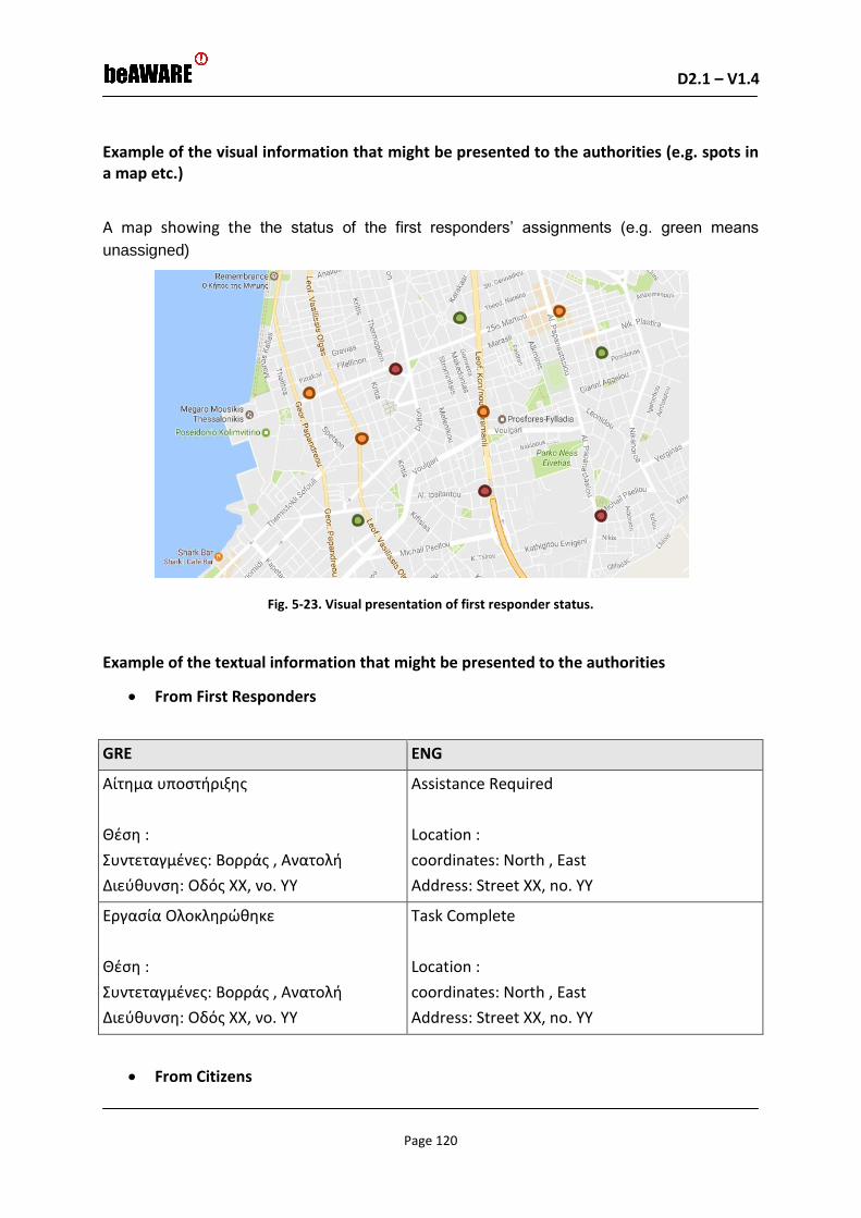
D2.1 – V1.4 D2.1 – V1.0
Page 120
Example of the visual information that might be presented to the authorities (e.g. spots in a map etc.)
A map showing the the status of the first responders’ assignments (e.g. green means
unassigned)
Fig. 5-23. Visual presentation of first responder status.
Example of the textual information that might be presented to the authorities
From First Responders
GRE ENG
Αίτημα υποστήριξης
Θέση :
Συντεταγμένες: Βορράς , Ανατολή
Διεύθυνση: Οδός XX, νο. ΥΥ
Assistance Required
Location :
coordinates: North , East
Address: Street XX, no. YY
Εργασία Ολοκληρώθηκε
Θέση :
Συντεταγμένες: Βορράς , Ανατολή
Διεύθυνση: Οδός XX, νο. ΥΥ
Task Complete
Location :
coordinates: North , East
Address: Street XX, no. YY
From Citizens

D2.1 – V1.4 D2.1 – V1.0
Page 121
o None
Example of messages that might be presented to the people
None
Example of messages that might be presented to first responders
None
Example of reports from the first responders that might be presented to the authority
(tasks etc.)
None
The roles under the term authority
PSAP, Fire Department, Municipalities, Traffic Police, EKAV (ambulance service)
Mobile application equipment
Smarphone
UC_304: Management of traffic emergencies
This Use Case concerns the monitoring of traffic jam situations in order to support a more
efficient deployment of the first reposnders.

D2.1 – V1.4 D2.1 – V1.0
Page 122
Fig. 5-24. Block Diagram of the UC304
Current Status (initial phase of the scenario)
• During the heatwave
What is known to the beAWARE system already
• Weather forecast
• Current situation of the traffic in the streets
What is happening
• A first responder (rescue service) is recording a video of a jammed street in another
location in the city
• Tweets are mentioning jammed streets in the first responder’s location
• Citizens are sending reports on jammed streets with images and text in another
location in the city
Outcome
• The authority redistributes first responders to more suitable locations
• The authority (e.g. municipality) sends notifications to citizens approaching the
jammed areas and suggests alternative ways

D2.1 – V1.4 D2.1 – V1.0
Page 123
Example of the visual information that might be presented to the authorities (e.g. spots in a map etc.)
Fig. 5-25. Visualization of real tiem traffic conditions in the city
Different colors depending on the status of the streets
Relative information about the traffic situation can be acquired through google traffic and
mobithess.gr
Photos from known locations:
.
Fig. 5-26. Traffic jam in the Thessaloniki ring road

D2.1 – V1.4 D2.1 – V1.0
Page 124
Fig. 5-27. Picture of traffic jam
Example of the textual information that might be presented to the authorities
GRE ENG
Η κίνηση στην οδό «Χ» είναι σε επίπεδο
«υψηλό».
Traffic in Street X has reached level “High”
Example of messages that might be presented to the people
GRE ENG
Η κίνηση στην οδό «Χ» είναι σε επίπεδο
«υψηλό». Σας συνιστούμε να επιλέξετε
μία εναλλακτική διαδρομή για τον
προορισμό σας
Traffic in Street X has reached level “High”.
Please be advised to avoid Street X and use
alternate rooting to your destination.
Example of messages that might be presented to first responders
GRE ENG
Η κίνηση στην οδό «Χ» είναι σε επίπεδο
«υψηλό». Κινηθείτε μέσω της οδού «Υ»
Traffic in Street X has reached level “High”. ”.
Redirect through street Y
Example of reports from the first responders that might be presented to the authority
(tasks etc.)

D2.1 – V1.4 D2.1 – V1.0
Page 125
None
The roles under the term authority
PSAP
Traffic Police
Mobile application equipment
Smartphone
UC_305: Management of Places for relief
This Use Case concerns the monitoring of the places of relief offered to people as a shelter
during the day, in the period of a heatwave.
Fig. 5-28. Block Diagram of the UC305
Current Status (initial phase of the scenario)
• During the heatwave
What is known to the beAWARE system already
• Weather forecast
• Current status of occupancy for the places of relief
• Capacity of each place

D2.1 – V1.4 D2.1 – V1.0
Page 126
What is happening
• A first responder (eg volunteer) or the person in managing the place is recording a
video of the crowded place
• Tweets are mentioning that the place is crowded
• Citizens are sending reports on jammed streets with images and text in another
location in the city
• Cameras on place are recording the number of people that are in each place
Outcome
• The authority informs first responders to direct people to other places
• The authority sends notifications to citizens regarding the occupancy of each place
and suggests alternative places
• The status of each place is shown on a map
• Can the map be updated automatically?
Example of the visual information that might be presented to the authorities (e.g. spots in a map etc.)
Fig. 5-29. Visualization of the status of places of relief in the city
Dots on a map (e.g. Google Map) showing the location of the places for relief and its
capacity.
Different colors depending on the status of each place’s occupancy (e.g. Green
means <50% of occupancy, yellow means <70%, orange means <90%, red means
>90%).

D2.1 – V1.4 D2.1 – V1.0
Page 127
Example of the textual information that might be presented to the authorities
GRE ENG
Ενέργεια:
Ο χώρος στην οδό «Χ, no. Y» έχει φτάσει στο
Z% της.
Θέση:
Διεύθυνση: Οδός Χ, νο. Υ
Action:
Place in street X, no. Y has reached Z% of its
capacity.
Location:
Address: Street X, no. Y
Example of messages that might be presented to the people
GRE ENG
Ο χώρος στην οδό «Χ, νo. Y» έχει φτάσει στο
όριο της χωρητικότητας του. Θα σας
συνιστούσαμε να μεταβείτε στο χώρο (ή
χώρους) που βρίσκεται (ή βρίσκονται) στην
οδό ΧΧ, νο. ΥΥ
Place in street X, no. Y has reached its
capacity, please be advised to use place(s)
Y/Z (address: Street YY) for relief.
Example of messages that might be presented to first responders
GRE ENG
Ο χώρος στην οδό «Χ, νo. Y» έχει φτάσει στο
όριο της χωρητικότητας του. Οδηγήστε τους
πολίτες στο (στους) χώρο (χώρους) που
βρίσκεται (ή βρίσκονται) στην οδό ΧΧ, νο. ΥΥ
Place X (address: Street XX) has reached its
capacity, please direct citizens to place(s) Y/Z
(address: Street YY) for relief.
Ο χώρος στην οδό «Χ, νo. Y» έχει φτάσει στο
όριο της χωρητικότητας του. Οδηγήστε τους
πολίτες στο (στους) χώρο (χώρους) που
βρίσκεται (ή βρίσκονται) στην οδό ΧΧ, νο. ΥΥ
Place X (address: Street XX) has reached its
capacity, please direct citizens to place(s) Y/Z
(address: Street YY) for relief.
Example of reports from the first responders that might be presented to the authority
(tasks etc.)
None
The roles under the term authority

D2.1 – V1.4 D2.1 – V1.0
Page 128
PSAP
Municipal Authorities
Mobile application equipment
Smartphone
UC_306: Response to Power Outage
This Use Case focuses on locating signals through the beAWARE app from people in distress
(e.g. elders or sick people who are stuck at home, people stuck in elevators, etc.).
Fig. 5-30. Block Diagram of the UC306
Current Status (initial phase of the scenario)
• During a heatwave event a power outrage has occurred
What is known to the beAWARE system already
• Weather forecast
What is happening
• Citizens are sending distress messages
• Hospitals informing for reaching capacity
Outcome

D2.1 – V1.4 D2.1 – V1.0
Page 129
• Messages to first responders
Example of the visual information that might be presented to the authorities (e.g. spots in a map etc.)
Fig. 5-31. Visual presentation of people in distress
Dots on a map (e.g. Google Map) in correspondence to the location that the citizen’s
text was sent
Dots on a map (e.g. Google Map) in correspondence to the location of available
hospitals (green dots) and hospitals that have reached capacity (red dots)
Example of the textual information that might be presented to the authorities
GRE ENG
Υπάρχουν άνθρωποι εγκλωβισμένοι σε
ασανσέρ
Θέση :
Συντεταγμένες: Βορράς , Ανατολή
Διεύθυνση: Οδός XX, νο. ΥΥ
People stuck in elevators
Location :
coordinates: North , East
Address: Street XX, no. YY

D2.1 – V1.4 D2.1 – V1.0
Page 130
GRE ENG
Υπάρχουν ηλικιωμένοι εγκλωβισμένοι σε σε
σπίτι χωρίς A/C
Θέση :
Συντεταγμένες: Βορράς , Ανατολή
Διεύθυνση: Οδός XX, νο. ΥΥ
Elder people stuck at home with no A/C
Location :
coordinates: North , East
Address: Street XX, no. YY
Example of messages that might be presented to the people
Advice/guidance on what to do until first responders arrive
Example of messages that might be presented to first responders
GRE ENG
Από νοσοκομεία σε PSAP
Το νοσοκομείο «Χ» έχει δεν έχει πλέον
διαθεσιμότητα κλινών οδηγήστε τους
ασθενείς σε άλλα νοσοκομεία
Θέση διαθέσιμων νοσοκομείων:
Συντεταγμένες: Βορράς , Ανατολή
Διεύθυνση: Οδός XX, νο. ΥΥ
From Hospitals to PSAP
Hospital X has reached capacity and cannot
receive more patients redirect patients to
other hospitals
Location of new hospitals:
coordinates: North , East
Address: Street XX, no. YY
GRE ENG
Από PSAP σε πυροσβεστική
Υπάρχουν εγκλωβισμένοι σε ασανσέρ
Θέση:
Συντεταγμένες: Βορράς , Ανατολή
Διεύθυνση: Οδός XX, νο. ΥΥ
From PSAP to Fire Department
People stuck in elevators
Location:
coordinates: North , East
Address: Street XX, no. YY

D2.1 – V1.4 D2.1 – V1.0
Page 131
GRE ENG
Από PSAP σε πυροσβεστική
Υπάρχουν ηλικιωμένοι σε σπίτι χωρίς A/C
Θέση:
Συντεταγμένες: Βορράς , Ανατολή
Διεύθυνση: Οδός XX, νο. ΥΥ
From PSAP to Fire Department
Elder people stuck at home with no A/C
Location:
coordinates: North , East
Address: Street XX, no. YY
GRE ENG
Από PSAP σε ΕΚΑΒ
Το νοσοκομείο «Χ» έχει δεν έχει πλέον
διαθεσιμότητα κλινών οδηγήστε τους
ασθενείς σε άλλα νοσοκομεία
Θέση διαθέσιμων νοσοκομείων:
Συντεταγμένες: Βορράς , Ανατολή
Διεύθυνση: Οδός XX, νο. ΥΥ
From PSAP to Ambulance Services
Hospital X has reached capacity and cannot
receive more patients redirect patients to
other hospitals
Location new hospitals:
coordinates: North , East
Address: Street XX, no. YY
Example of reports from the first responders that might be presented to the authority
(tasks etc.)
Transport
ENG GRE
Απεγκλωβισμός / απομάκρυνση ηλικιωμένων
ολοκληρώθηκε
Θέση:
Συντεταγμένες: Βορράς , Ανατολή
Διεύθυνση: Οδός XX, νο. ΥΥ
Evacuation Complete
Location:
coordinates: North , East
Address: Street XX, no. YY
The roles under the term authority
PSAP
Mobile application equipment
Smartphone

D2.1 – V1.4 D2.1 – V1.0
Page 132
6 User Requirements
This section presents the description of the initial user requirements for beAWARE based on
the understanding and clarification of how users will interact with the system and benefit
from such interactions.
The tables below specify these operational user requirements per the use cases of each
scenario. The process for generating this set of requirements and for transforming it into a
formal set of system requirements is defined as the requirements elicitation process and it
is reported in section 2.
6.1 Requirements for Flood scenario use cases
UR# UC# Requirement
name
Requirement description
UR_101 All Type of
visualization
Display information to authorities in a web-gis platform (citizen and first responders reports by calls, apps, social media)
UR_102 101,102,103
104,105,106, 108
Map of the
AMICO Flood
EWS results
Display reliable and trustful flood forecasts, potential dangerous situations and the forecasted level of risk to the authorities, based on the results of the EarlyWarning System AMICO (improved with the assimilation of Satellite data (snow cover, soil moisture, etc.) and Meteorological forecasts data with a finer spatial resolution provided by FMI)
UR_103 101,102,103
104,105,106, 108
Flood warnings Provide authorities/citizens with automatic warnings on river levels overtopping some predefined alert thresholds, based on forecast results
UR_104 102, 103, 104,
105, 106
Send/receive
emergency
reports
Allow citizens to send text, images, audio and video messages from their mobile phone (for the different operative systems) and from their social media account to the authority during bad weather conditions when the GPS signal is low.
UR_105 104 Send task
reports
Allow First Responders to send reports about their assignments from their mobile phone to local authorities

D2.1 – V1.4 D2.1 – V1.0
Page 133
UR# UC# Requirement
name
Requirement description
UR_106 103,106 Visualize video
cameras
Display streamed video from video cameras to the authorities/citizens
UR_107 102,103, 104,
105,106
Localize video,
audio and
images
Provide authorities with the ability to localize videos, audio and images sent by citizens from their mobile phones
UR_108 104 Localize task
status
Provide authorities with the ability to localize
first responders reports regarding the status
of their assigned tasks
UR_109 102
Localize tweets Provide authorities with the ability to localize Twitter messages concerning a flood event
UR_110 102
Localize calls Provide authorities with the ability to localize Phone Calls to an emergency number concerning a flood event
UR_111 102
Detect flooded
elements from
video
Provide authorities with the ability to detect and count flooded elements (e.g. cars and people inside the river)from video and images sent from mobile phones and social media
UR_112 102
Detect element
at risk from
reports
Provide authorities with the ability to detect the number of element at risk and the degree of emergency from text sent by the mobile app and by social media
UR_113 102
Detect element
at risk from calls
Provide authorities with the ability to detect the number of element at risk and the degree of emergency from emergency calls
UR_114 102, 103, 106
Detect water
depth and
velocity
Provide authorities with the ability to detect water depth and water velocity from video and images sent by the mobile app and social media
UR_115 all Real time flood
mapping
Display flooded areas in real time to authorities/citizens
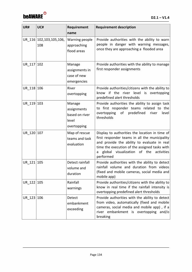
D2.1 – V1.4 D2.1 – V1.0
Page 134
UR# UC# Requirement
name
Requirement description
UR_116 102,103,105,106,
108
Warning people
approaching
flood areas
Provide authorities with the ability to warn people in danger with warning messages, once they are approaching a flooded area
UR_117 102 Manage
assignments in
case of new
emergencies
Provide authorities with the ability to manage first responder assignments
UR_118 106 River
overtopping
Provide authorities/citizens with the ability to know if the river level is overtopping predefined alert thresholds
UR_119 103 Manage
assignments
based on river
level
overtopping
Provide authorities the ability to assign task to first responder teams related to the overtopping of predefined river level thresholds
UR_120 107 Map of rescue
teams and task
evaluation
Display to authorities the location in time of first responder teams in all the municipality and provide the ability to evaluate in real time the execution of the assigned tasks with a global visualization of the activities performed
UR_121 105 Detect rainfall
volume and
duration
Provide authorities with the ability to detect rainfall volume and duration from videos (fixed and mobile cameras, social media and mobile app)
UR_122 105 Rainfall
warnings
Provide authorities/citizens with the ability to know in real time if the rainfall intensity is overtopping predefined alert thresholds
UR_123 106 Detect
embankment
exceeding
Provide authorities with the ability to detect from video, automatically (fixed and mobile cameras, social media and mobile app) , if a river embankment is overtopping and/o breaking
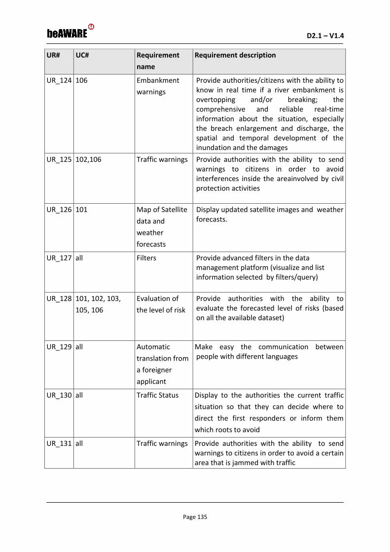
D2.1 – V1.4 D2.1 – V1.0
Page 135
UR# UC# Requirement
name
Requirement description
UR_124 106 Embankment
warnings
Provide authorities/citizens with the ability to know in real time if a river embankment is overtopping and/or breaking; the comprehensive and reliable real-time information about the situation, especially the breach enlargement and discharge, the spatial and temporal development of the inundation and the damages
UR_125 102,106 Traffic warnings Provide authorities with the ability to send warnings to citizens in order to avoid interferences inside the areainvolved by civil protection activities
UR_126 101 Map of Satellite
data and
weather
forecasts
Display updated satellite images and weather forecasts.
UR_127 all Filters Provide advanced filters in the data management platform (visualize and list information selected by filters/query)
UR_128 101, 102, 103,
105, 106
Evaluation of
the level of risk
Provide authorities with the ability to evaluate the forecasted level of risks (based on all the available dataset)
UR_129 all Automatic
translation from
a foreigner
applicant
Make easy the communication between people with different languages
UR_130 all Traffic Status Display to the authorities the current traffic
situation so that they can decide where to
direct the first responders or inform them
which roots to avoid
UR_131 all Traffic warnings Provide authorities with the ability to send warnings to citizens in order to avoid a certain area that is jammed with traffic

D2.1 – V1.4 D2.1 – V1.0
Page 136
6.2 Requirements for Fire scenario use cases
UR# UC# Requirement
name
Requirement description
UR_201 201, 204 Detection of
people and
goods in danger
Display information authorities/first
responders to detect people, cars and
buildings in danger.
UR_202 201,202,203,204 Detection of
critical aspects
Provide authorities/first responders
information in order to detect the following
kind of situation, process, material or
condition that can cause a wildfire or that
could intensify its damaging impacts:
Namely drought, air temperature and other
weather aspects, fuel accumulation spots,
crowds, etc.
UR_203 201,202,204 Study of the
smoke behaviour
Provide information authorities/first
responders with a study of the smoke
behavior (vertical/inclined, column, smoke
color…).
UR_204 201,202,204 Identification of
the fuel being
burned
Provide information to authorities/first
responders to know the type of fuel being
burned by the colour and the shape of the
smoke
UR_205 201-202-204 Analisis of
advancing fire
Provide authorities/first responders with an
analysis of the the advancing fire (flame
progression, height and length).
UR_206 201,202,203,204 Specific weather
data
Provide authorities/first responders and
citizens with specific weather data of the
Devesa place, as it has a specific
microclimate that might be different from
other places.

D2.1 – V1.4 D2.1 – V1.0
Page 137
UR# UC# Requirement
name
Requirement description
UR_207 201,202,204
Aerial images Display authorities/first responders to
visualize aerial images of the smoke and the
trajectory flames. It will provide information
about the extension and the damages (kind
of damages, and so on), the tracking of the
fire, vehicles and people around the spot, in
order to find out possible suspects or
victims. Furthermore, if these aerial images
provide thermal information it can be used
for looking over the fire perimeter once it
has been extinguished, in order to locate
sleeper fire and to avoid possible
reproduction. This aerial images are a must,
because the use case is in a forest, and we
have not references in the forest, the only
tool that can help the coordination center
and first responders are aerial images to
have information about forest fires
(extension, direction of fires, damages,
appropriate mobilization of resources, an
soon)
UR_208 201,202,203,204 Acces to road
traffic cameras
Allow authorities/first responders to have
access to the cameras located at CV-500 (La
Devesa main road) and CV-5010. Although
there are already installed cameras, they are
managed and visualized by autonomic
resources.
UR_209 201,202,203,204 Electronic traffic
panels
Display authorities/first responders to
display in electronic traffic panels useful
information and evacuation instructions in
case.
UR_210 201,202,204 Mobile
application
Provide citizens to communicate a fire alert,
detected neglects or other risk situations
and even send visual data through a mobile
application.

D2.1 – V1.4 D2.1 – V1.0
Page 138
UR# UC# Requirement
name
Requirement description
UR_211 201.202.203.204 Location of
vehicles and
personnel
involved
Display authorities/first responders to
visualize GPS location and/or real time
footage of vehicles and personnel on the
incident site. Transmitted to an online map
where the coordination centres can follow
both the development of the incident and
the location and amount of resources. The
online map will also provide the possibility
of interacting with the police and other
agencies involved
UR_212 201,202,204 Traffic warnings Sending warnings to citizens in order to avoid interferences inside the area.
UR_213 201,202,203,204 Recommendatio
ns
Sending recommendations to citizens.
UR_214 203 Warnings Sending warnings of pre-emergency alerts to citizens by authorities
UR_215 201,204 Evacuation
orders
Ordering evacuations of citizens at risk.
UR_216 201,202,203,204 Internal sharing
of information
Sharing data (images, videos, geolocation, reports) regarding the forest fire among authorities & first responders
UR_217 201,202,203,204 Twitter analisis
and warning
Warning authorities/first responders about Twitter messages concerning the forest fire event.
UR_218 201,202,204 Automatic
detection system
Having an automatic detection system of the forest fire, which is connected to firefighters and police officers
UR_219 201,202,203,204 Coordination and
communication
betwenn
different
resources
Provide communication between authorities and first responders, in order to improve their coordination.

D2.1 – V1.4 D2.1 – V1.0
Page 139
UR# UC# Requirement
name
Requirement description
UR_220 201,202,203,204 Improvement of
the signal for
telephones and
emergency
communication
Provide authorities/first responders with an accurate coverage of telephone mobile lines and emergency communication due to there is currently a lack of signal in some spots of the area.
UR_221 201,202,203,204 Geolocalitation
of telephone calls
To geolocalize a mobile phone citizen call by sending a request permission message to the citizen, who would accept to be tracked temporarily.
UR_222 201,202 Filter of the
emergency
messages
Transfer emergency calls by writing (only minor emergencies or only information call). The aim is to save time operator and do not lose emergency calls
UR_223 201 Automatic
selection of the
level of
emergency
This can be doing only with the operator’s supervision. The aim is to save time and do not lost emergency calls
UR_224 201,202 Automatic
translation from
a foreigner
applicant
Make easy the communication between people with different languages
UR_225 201,202 Quick search of
events and
applicants
Data storage, in order to improve indexation of information relative to events and applicants
6.3 Requirements for heatwave scenario use cases
UR# UC# Requirement
name
Requirement description
UR_301 301, 302, 305,
306
Real time
weather
forecast
Provide the authorities with real time
weather forecast in relation to the
progression of the heatwave phenomenon

D2.1 – V1.4 D2.1 – V1.0
Page 140
UR# UC# Requirement
name
Requirement description
UR_302 301 Automatic
warning
beAWARE system to generate and provide
the authorities with an automatic warning
when an imminent heatwave phenomenon
is forecasted
UR_303 302 Risk assessment
for a forest fire
Provide the authorities with a risk
assessment regarding the probability of a
forest fire to occur during or in the
upcoming period after a heatwave. The
relevant authorities will have an
assessment of a fire risk based on the
weather forecast during a heatwave and
especially during the following days
UR_304 303, 305 Heatwave
intensity
Provide the authorities with a risk
assessment regarding the intensity of the
phenomenon in the city.
UR_305 303, 304, 305 Possible
locations for
incidents
Display to the authorities visual
information about possible locations in the
city (or outside the city) where a situation
is more likely to develop that will require
rescue team intervention (for example,
based on past experience, traffic jam
and/or accidents will be more likely to
occur at a main street intersection/ public
park/ entrance to hospitals or banks…
etc.). In such cases a decision might be
made to send rescue teams in advance to
shorten response time if/when an incident
occurs
UR_306 303, 305, 306 Number of
people affected
Provide the authorities an estimation of
the people that might be affected from the
phenomenon and in which areas
UR_307 306 Power needs Provide the authorities an estimation on
the power needs during a heatwave based
on its foreseen progression

D2.1 – V1.4 D2.1 – V1.0
Page 141
UR# UC# Requirement
name
Requirement description
UR_308 303, 306 Infrusrtucture
overload
Provide the authorities an estimation of
damage/overload to the city’s
infrastructure (phone lines, electricity,
water, etc)
UR_309 303 False Alarms Provide to the authorities a procedure to
confirm necessity of rescue teams so they
are not sent needlessly to one place
instead of somewhere else where they are
needed more urgently, therefore the
ability to handle false alarms.
UR_310 303, 304, 305 City-wide
overview of the
event
Provide the authorities to have a city-wide
overview of the event – allow decision
making authorities an overall view of all
incidents handled at any point in time/ see
where all rescue teams are located in real-
time to allow them to make informed
decisions regarding who to send where…
etc
UR_311 301, 302, 303,
304, 305, 306
Information
Storage
Provide the authorites with access to all
historical information by providing storage
for all information for future lessons-
learned purposes, so that after the heat
wave situation is over, decision making
authorities can review the information
gathered and handled during the event,
and set-up better procedures to handle
future events more efficiently
UR_312 301, 304, 305,
306
Warning citizens Provide to citizens warnings through the
beAWARE app, of an imminent heatwave
and a list of proactive measures and how
to reduce its effects
UR_313 303 First responders
status
Provide to the authorities the current
status and location of all first responders
when they are performing their tasks

D2.1 – V1.4 D2.1 – V1.0
Page 142
UR# UC# Requirement
name
Requirement description
UR_314 303 Assign tasks to
first responders
Allow authorities to assign additional tasks
to those first responders who are available
or even instruct those who are able to
assist other responders
UR_315 303, 304 Traffic Status Display to the authorities to monitor the
current traffic situation so that they can
decide where to direct the first responders
or inform them which roots to avoid
UR_316 305 Capacity of
relief places
Provide to the authorities the current state
of the available capacity of all relief places
provided to the public
UR_317 303 304, 306 Areas with
power outage
Display to the authorities the areas where
there is a power outage.
UR_318 303, 306 Trapped citizens Allow authorities to know if there are
people trapped (e.g. in an elevator) and
display where
UR_319 303, 306 Trapped elders
at home
Allow authorities to know if there are elder
people trapped in houses without an A/C
and display where
UR_320 303, 306 Hospital
availability
Show to the authorities the current
availability of the hospitals.
UR_321 301, 306 Affected area Provide to the authorities with a prediction
of the affected area
UR_322 304, 305, 305 Information for
incident status
from Social
Media
Provide to the authorities information
regarding potential risks in case there is a
situation inside the city (eg car accident,
etc.) gathered from social media
UR_323 305, 306 Information for
Hospital Status
from Social
Media
Provide to the authorities information
regarding overcrowded hospitals and
places offered to the public with a/c,
gathered from social media

D2.1 – V1.4 D2.1 – V1.0
Page 143
UR# UC# Requirement
name
Requirement description
UR_324 304 Information for
existing
situation in the
from Social
Media
Provide to the authorities information
regarding existing traffic conditions all over
the city grid gathered from social media
UR_325 305 Suggested
places for relief
Provide citizens with information regarding
the suggested places for relief through an
app.
UR_326 301, 302, 303,
304, 305, 306
Type of
visualization
Display to the authorities/citizens all the information in a web-gis platform
UR_327 304, 305, 306 Send
emergency
reports
Allow citizens to send text, images and video messages from their mobile phone (for the different operative systems) and from their social media account to the authority.
UR_328 303, 304 Send task
reports
Allow First Responders to send reports about their assignments from their mobile phone to local authorities
UR_329 304, 305 Visualize video
cameras
Display streamed video from video cameras to the authorities/citizens
UR_330 303, 304, 305,
306
Localize video
and images
Provide authorities with the ability to localize videos and images sent by citizens from their mobile phones
UR_331 303 Localize task
status
Provide authorities with the ability to detect the location of first responders
UR_332 304, 305, 306 Localize tweets Provide authorities with the ability to localize Twitter messages
UR_333 304, 305, 306 Localize calls Provide authorities with the ability to localize Phone Calls to an emergency number concerning citizens who are trapped
UR_334 303 Manage
assignments in
case of new
emergencies
Provide authorities with the ability to manage first responder assignments

D2.1 – V1.4 D2.1 – V1.0
Page 144
UR# UC# Requirement
name
Requirement description
UR_335 303 Map of rescue
teams and task
evaluation
Display to authorities the movements of first responder teams in all the municipality and provide the ability to evaluate in real time the execution of the assigned tasks with a global visualization of the activities performed
UR_336 304 Traffic warnings Provide authorities with the ability to send warnings to citizens in order to avoid a certain area that is jammed with traffic
UR_337 303 Location of
vehicles and
personnel
involved
Allow authorities/first responders to
visualize GPS location and/or real time
footage of vehicles and personnel on the
incident site. Transmitted to an online map
where the coordination centres can follow
both the development of the incident, and
the location and amount of resources. The
online map will also provide the possibility
of interacting with the police and other
agencies involved
UR_338 304, 305, 306 Warnings Allow authorities to send warnings of pre-emergency alerts to citizens.
UR_339 303 Evacuation
orders
Allow authorities to order evacuations of citizens at risk.
UR_340 303, 304, 305,
306
Internal sharing
of information
Allow authorities and first responders to share data (images, videos, geolocation, reports)
UR_341 304, 305, 306 Twitter analysis
and warning
Allow authorities/first responders to be warned by Twitter messages concerning traffic jam, availability of places of relief, potential hazards or people in danger
UR_342 303, 304, 305,
306
Coordination
and
communication
between
different
resources
Provide communication between authorities and first responders, in order to improve their coordination.
D2.1 – V1.4 D2.1 – V1.0
Page 145
7 Conclusions
This document described the initial set of use cases and requirements of beAWARE, the
methodology used to define the use cases and the risks, challenges and the impacts
identified and analysed in order to define these use cases.
Based on this deliverable, a consolidated set of system requirements will be elicited. This will
include joint consideration of all user requirements from all the scenarios, generalization,
abstraction and clustering of similar or associated user requirements, formalization and
standardization of the requirement specifications, and allocation of system requirements to
BeAWARE subsystems. This set of system requirements will be elaborated in D7.2 – System
Requirements and Architecture.
D2.1 – V1.4 D2.1 – V1.0
Page 146
8 References
AAWA Alto Adriatico Water Authority, 2017. Flood Risk Management Plan of the Eastern Alps Hydrographic District. Decree of the President of the Italian Council of Ministers of October 27, 2016 (published in the Offical Gazette n. 29, of Febbruary 4, 2017. http://notizie.adbve.it/download/pgra-dpcm-27-10-2016.pdf
Baccini, M., Biggeri, A., Accetta, G., Kosatsky, T., Katsouyanni, K., Analitis, A., Anderson, H. R., Bisanti, L., D’Ippoliti, D., Danova, J., Forsberg, B., Medina, S., Paldy, A., Rabczenko, D., Schindler, C. et al., 2008. Heat effects on mortality in 15 European cities. Epidemiology, 19(5), 711–719. DOI:10.1097/EDE.0b013e318176bfcd.
Barbi, A., Monai, A., Racca, R., and Rossa, A., 2012. Recurring features of extreme autumnal rainfall events on the 5 Veneto coastal area, Nat.Hazard. Earth Sys. Sci., 12, 2463–2477, doi:10.5194/nhess-12-2463-2012, 2012.
Cardona, O.D., 2010. Disaster risk and vulnerability: notions and measurement of human and environmental insecurity. In: Brauch, H.G., Spring, U.O., Mesjasz, C., Grin, J., Kameri‐Mbote, P., Chourou, B., Dunay, P., Birkmann, J., 2011. Coping with global environmental change, disasters and security ‐ threats, challenges, vulnerabilities and risks. Springer Verlag, Berlin‐Heidelberg‐New York.
Crichton, D., 1999. Natural Disaster Management: A Presentation to Commemorate the International Decade for Natural Disaster Reduction (IDNDR). Tudor Rose Holdings Ltd, 1999, Ch. The Risk Triangle.
EASAC European Academies Science Advisory Council, 2013. Trends in extreme weather events in Europe: implications for national and European Union adaptation strategies. EASAC policy report 22, November 2013, ISBN: 978-3-8047-3239-1
http://www.easac.eu/fileadmin/PDF_s/reports_statements/Easac_Report_Extreme_Weather_Events.pdf
EEA, European Environment Agency, 2010. Mapping the impacts of natural hazards and technological accidents in Europe, an overview of the last decade. Publications Office of the European Union, Luxembourg.
EEA European Environment Agency, 2011. Mapping the impacts of natural hazards and technological accidents in Europe (EEA Technical report No 13/2010). European Environment Agency, Copenhagen. http://www.eea.europa.eu/ publications/mapping-the-impacts-of-natural.
EEA European Environment Agency, 2012. Climate change, impacts and nvulnerability in Europe 2012. An indicator-based report. Report No 12/2012,. ISSN 1725-9177.
EC European Commission, 2007. Directive 2007/60/EC of the European Parliament and of the Council of 23 October 2007 on the assessment and management of flood risks. EC, Brussels.

D2.1 – V1.4 D2.1 – V1.0
Page 147
Ecodecision, 2006. Evaluation économique des dommages liés aux inondations. Internet. http://www.eau-artois-picardie.fr/IMG/pdf/RapportFinal.pdf. Accessed 31 May 2010.
European Forest Fire Networks Project (EUFOFINET). European Glossary for Wildfires and Forest Fires, 2012. Promoting early action, http://www.fire.unifreiburg.de/literature/EUFOFINET-Fire-Glossary.pdf
Ferri, M., Monego, M., Norbiato, D., Baruffi, F., Toffolon, C., Casarin, R., 2012. AMICO: la piattaforma previsionale per i bacini idrografici del nord est adriatico (I e II)”, XXXIII National Conference on Hydraulics and Hydraulic Structures "IDRA 12", Brescia, Italy, September 10-15, 2012.
Fischer, E. M., and C. Schär, 2010. Consistent geographical patterns of changes in high-impact European heatwaves, Nature Geoscience, 3(6), 398-403. http://iacweb.ethz.ch/staff/fischer/download/etc/fischer_schaer_2010.pdf
FLOODsite project, 2005. Language of Risk, PROJECT DEFINITIONS. Glossary of terms, March 2005, Report: T32-04-01.
FLOODsite, 2009. Flood risk assessment and flood risk management. An introduction and guidance based on experiences and findings of FLOODsite (an EU‐funded integrated project). Deltares‐Delft Hydraulics, Delft
Gaillard, J.C., 2010. Vulnerability, capacity, and resilience: perspectives for climate and development policy. Journal of International Development. 22, 218‐232.
Gasper, D., 2010. The idea of human security. In: O’Brien, K., St. Clair, K.A., Kristoffersen, B., 2010. Climate change, ethics and human security. Cambridge Univ. Press, Cambridge.
Haylock, M., N. Hofstra, A. K. Tank, E. Klok, P. Jones, and M. New, 2008. A European daily high-resolution gridded data set of surface temperature and precipitation for 1950–2006, J. Geophys. Res., 113, D20119, doi:10.1029/2008JD010201
Halcrow, 2008. Flood Risk Assessment Indicators, Methods and Datasets – Scoping Study. Review report commissioned by the Office of Public Works, Ireland.
Kulturisk FP7 Project, 2011. D‐1‐4. The Total Cost of Hydrological Disasters ‐ Int. ver.FP7‐ENV‐2010 | Project 265280
Martina, M., 2012. Le azioni dell’alluvione sui fabbricati civili e di danni conseguenti. Workshop: Valutazione del rischio idraulico in ambito montano ed applicazione della direttiva ”alluvioni” (Presentazione, Free University of Bozen, Maggio 2012).
Mazzoleni, M., Verlaan, M., Alfonso, L., Monego, M., Norbiato, D., Ferri, M., and Solomatine, D., 2017. Can assimilation of crowdsourced data in hydrological modelling improve flood prediction?, Hydrol. Earth Syst. Sc., 21, 839–861, doi:10.5194/hess-21-839-2017, 2017
Munich Re NatCatSERVICE (https://www.munichre.com/en/reinsurance/business/non-life/natcatservice/index.html)
NAS and NMI, 2013. Extreme Weather Events in Europe: Preparing for Climate Change Adaptation. Oslo: Norwegian Academy of Science and Letters and the Norwegian Meteorological Institute. http://www.dnva. no/binfil/download.php?tid=58783

D2.1 – V1.4 D2.1 – V1.0
Page 148
Penning-Rowsell, E., Johnson, C., Tunstall, S., Tapsell, S., Morris, J., Chatterton, J. and Green, C., 2005. The Benefits of Flood and Coastal Risk Management: A manual of Assessment Techniques (The Multi-coloured Manual). Flood Hazard Research Centre, Middlesex university. Middlesex University Press, London.
Rysman, J.-F., Lemaître, Y., and Moreau, E., 2016. Spatial and temporal variability of rainfall in the Alps–Mediterranean Euroregion., J. Appl.Meteorol. Clim., 55, 655–671, doi:10.1175/JAMC-D-15-0095.1, 2016.
Schneider, S.H., Semenov, S., Patwardhan, A., Burton, I., Magadza, C.H.D., Oppenheimer, M., Pittock,A.B., Rahman, A., Smith, J.B., Suarez A., Yamin, F., 2007. Assessing key vulnerabilities and the risk from climate change. In: Parry, M.L., Canziani, O.F., Palutikof, J.P., van der Linden, P.J., Hanson, C.E., 2007. Climate change 2007: impacts, adaptation and vulnerability. Contribution of Working Group II to the Fourth Assessment Report of the IPCC. Cambridge University Press, Cambridge.
Scorzini, A. and Frank, E., 2015. Flood damage curves: new insights from the 2010 flood in Veneto, Italy., J. Flood Risk Manag., –, 1–12, doi:10.1111/jfr3.12163, 2015.
Smith, R., 1979. The influence of mountains on the atmosphere., Adv. Geophys., 21, 87–230, doi:10.1016/S0065-2687(08)60262-9, 1979.
Van der Linden P., Mitchell JFB, 2009. Climate Change and its impacts, Met Office, UK, 160
Veneto Region, 2011. Veneto. La grande alluvione. http://docplayer.it/2849124-Veneto-la-grande-alluvione.html
Wisner, B., Blaikie, P., et al., 2004. At risk: natural hazards, people's vulnerability and disasters, second ed. Routledge, London.
Working Group of Flood, 2012. Flood Risk Management, Economics and Decision Making Support. Resource document for the delivery D.1 of The work programme of the Common Implementation Strategy for the water framework directive 2010-2012 http://ec.europa.eu/environment/water/flood_risk/pdf/WGF_Resource_doc.pdf
UNISDR United Nations Office for Disaster Risk Reduction, 2009. Terminology on disaster risk reduction. UNISDR, Geneva.