use of geoinformatics technique - maharashtra · mapsource configuration mannual 76 –83 19. ......
TRANSCRIPT

Govt. Of Maharashtra Tribal Development Department
The Scheduled Tribes And Other Traditional Forest Dwellers (Recognition Of
Forest Rights) Act 2006 & Rules 2008
Use Of GeoInformatics Technique
Tribal Research & Training Institute 28, Queen’s Garden Pune
Web Site: http://trti.mah.nic.in

C:\Documents and Settings\a\Desktop\TRTI-VGISTrainingFinal\INDEX.doc
Index
SrNo Description Page Nos
1 Geo-Informatics Application Path up to SDLC 1 - 1
2. •Öß.¯Öß.‹ÃÖ.μÖÓ¡ÖÖ“Öß †Öêôû�Ö 2 - 2
3. •Öß.¯Öß.‹ÃÖ.ÃÖÓμÖÓ¡ÖÖÃÖÖšüß ´ÖÖê•Ö�Ö߯Öæ¾ÖÔ ÃÖÓ� êúŸÖÖÓ�úÖÓ“μÖÖ ÃÖæ“Ö−ÖÖ 3 - 4
4. ¾Ö−Ö�Öê¡ÖÖ“Öß ´ÖÖê•Ö�Öß ÃÖã¹ý �ú¸ü�μÖÖ¯Öæ¾Öá“Öß ¯Öæ¾ÖÔŸÖμÖÖ¸üß 5 - 5
5. •Öß.¯Öß.‹ÃÖ.«üÖ¸êü ´ÖÖê•Ö�Öß �ú¸üŸÖÖ−ÖÖ ¾ÖÖ¯Ö¸üÖ¾ÖμÖÖ“Öß −ÖÖë¤ü¾ÖÆüß 6 - 6
6. Upload Slip Generated By Web Site At SDO 7 - 7
7. Measurement Report Generated By Web Site At SDO 8 - 9
8 Geo-Informatics Analysis Path For Verification At DLC 10 - 10
9. List Of Log In For Verification Unit 11 - 11
10. Download Manual Of GPX Files From Website Of TRTI 12 -27
11. Village Level Measurement Analysis Report Form III 28- 28
12. GPX File Analysis Using MapSource Software 29 - 44
13. GPX Files & Satellite Image Analysis Using TRTI-VGIS Software
45 - 59
14. Uploading Observations From Measurement Analysis Report Form III In Website Of TRTI
60 - 67
15. Measurement Analysis Slip - Area Measured With GPS 68 - 69
16. Measurement Analysis Slip -Area Measured Without GPS 70 - 71
17. Installation Manual 72 - 75
18. MapSource Configuration Mannual 76 –83
19. Copy Dataset To Computer/Data Structure On Local Computer
84 - 84

Forest Rights Act 2006, (Geo-Informatics Application Path up to SDLC)
2.GPS ManWill Obtain Details Of Claimant from Forest Rights Committee And Fill In the same in his Register.1
3.GPS ManIn Consultation of Forest Rights Committee, GPS man will take Measurement of Plot & Feeds Claimant Code ( 13 digit ) into GPS instrument. Will fill the date & time of measurement in register
5.SDLC (In SDO Office)1. Will take Xerox copy of register of GPS Man in every visit.2. Download Data To Computer From GPS Machine /Data Card3. Will Prepare gpx file.
6(A).SDLC (In SDO Office)1. Upload gpx file and claimant details To Web Site of TRTI2. Print Measurement Report using WebSite of TRTI3. Print Upload Slip and retain it in the office, After arrival of Case File fill the details and attach it with Case File & submitafter scrutiny etc. to District Level Committee
4.GPS ManWill report to SDO Office as per need with the GPS instrument ( containing measurement) and the filled in register.
1. Forest Right Committee, At Village Level1. Will Provide Claimant Details To GPS Man.
2. The committee will also provide the date for measurement and
will remain present at the time of measurement.
7.GPS ManAfter collecting the Measurement Report From SDLC Office and after making the necessary entry in his Register will handover the same to concern forest right committee
6(B).SDLC (In SDO Office)Handover one copy of Printed Measurement Report (Containing Claimant Details, Map, & Area etc.) To GPS Man and retain one copy with office
8.Forest Right Committee, At Village LevelWill attach the Measurement Report to respective case files and
submit to Gramsabha for Resolution etc. and onward submission to SDLC
1

•Öß.¯Öß.‹ÃÖ. μÖÓ¡ÖÖ“Öß †Öêôû�Ö
•Öß.¯Öß.‹ÃÖ. •Öß.¯Öß.‹ÃÖ.´Æü�Ö•Öê �»ÖÖê²Ö»Ö ¯ÖÖê×—Ö¿Ö−Ö ×ÃÖÙüß´Ö. μÖÖ ×ÃÖÙüß´Ö´Ö¬μÖê †Ö¯Ö�ÖÖÃÖ ¯Ö飾Öß¾Ö¸üᯙ †Ö¯Ö»Öê ãÖÖ−Ö ×−ÖÛ¿“ÖŸÖ �ú¸üŸÖÖ μÖêŸÖê. ãÖÖ−Ö ×−ÖÛ¿“ÖŸÖ �ú¸üŸÖÖ−ÖÖ †Ö¯Ö�Ö ˆ³Öê †ÃÖ»Öê»μÖÖ Ã£ÖÖ−ÖÖÓ“Öê †�ÖÖÓ¿Ö ¾Ö ¸êü�ÖÖÓ¿Ö ¯ÖÏÖ¯ŸÖ ÆüÖêŸÖÖŸÖ. ×¾Ö×¾Ö¬Ö Ã£ÖÖ−ÖÖÓ“Öê †�ÖÖÓ¿Ö ¸êü�ÖÖÓ¿Ö ¯ÖÏÖ¯ŸÖ —ÖÖ»μÖÖ¾Ö¸ü ŸÖê •ÖÖê›ü�ÖÖ¸üß ¸êü‘Ö ¾ÖÖ¯Ö¹ý−Ö �Öê¡Ö ×−ÖÛ¿“ÖŸÖ �ú¹ý−Ö ŸμÖÖ �Öê¡ÖÖ“Öê �Öê¡Ö±úôû ÃÖ´Ö•Öæ ¿Ö�úŸÖê. μÖÖ �Öê¡ÖÖ“Öê †�ÖÖÓ¿Ö ¸êü�ÖÖÓ¿Ö ÃÖ´Ö•Ö»μÖÖ´Öãôêû ÃÖ¤ü¸ü �Öê¡Ö −Ö�úÖ¿ÖÖ¾Ö¸ü ¤ü¿ÖÔ×¾Ö�Öê ÃÖÖê¯Öê •ÖÖŸÖê.
•Öß.¯Öß.‹ÃÖ.μÖÓ¡Ö •Öß.¯Öß.‹ÃÖ.μÖÓ¡Ö Æêü ¯Ö飾Öß³ÖÖê¾ÖŸÖß ×±ú¸ü�ÖÖ-μÖÖ ˆ¯Ö�ÖÏÆüÖÓ¿Öß ÃÖÓ¯Ö�Ôú ÃÖÖ¬Öæ−Ö Ã¾ÖŸÖ:“Öê ¯Ö飾Öß¾Ö¸üß»Ö Ã£ÖÖ−Ö ×−ÖÛ¿“ÖŸÖ �ú¸üŸÖê. •Öß.¯Öß.‹ÃÖ.μÖÓ¡Ö ˆ¯Ö�ÖÏÆüÖ¿Öß ÃÖÓ¯Ö�Ôú ÃÖÖ¬ÖŸÖ †ÃÖ»μÖÖ−Öê ŸμÖÖ“ÖÖ ¾ÖÖ¯Ö¸ü �Öã»μÖÖ �Öê¡ÖÖŸÖ“Ö �ú¸üŸÖÖ μÖêŸÖÖê. •Öß.¯Öß.‹ÃÖ.μÖÓ¡Ö ÃÖã¹ý �êú»μÖÖ−ÖÓŸÖ¸ü ŸμÖÖ �Öê¡ÖÖŸÖ ˆ¯Ö»Ö²¬Ö †ÃÖ»Öê»μÖÖ ×�ú´ÖÖ−Ö “ÖÖ¸ü ˆ¯Ö�ÖÏÆüÖÓ¿Öß ÃÖÓ¯Ö�Ôú —ÖÖ»μÖÖ−ÖÓŸÖ¸ü •Öß.¯Öß.‹ÃÖ.μÖÓ¡ÖÖ“ÖÖ ¾ÖÖ¯Ö¸ü �ú¸üŸÖÖ μÖêŸÖÖê. μÖÖ μÖÓ¡ÖÖÃÖ †−Öê�ú ¯ÖÏ�úÖ¸ü“Öê ÃÖë™üà�•Ö †ÃÖæ−Ö ŸμÖÖ“Öß ´ÖÖ×ÆüŸÖß ¯Öãœüᯙ ³ÖÖ�ÖÖŸÖ ×¤ü»Öê»Öß †ÖÆêü.
•Öß.¯Öß.‹ÃÖ.μÖÓ¡ÖÖ«üÖ¸êü �Öê¡Ö±úôû×−ÖÛ¿“ÖŸÖßÃÖÖšüß •Öß.¯Öß.‹ÃÖ.´Ö¬Öᯙ Tracks μÖÖ †Öòò¯¿Ö−ÖÖ“ÖÖ ¾ÖÖ¯Ö¸ü �ú¸üÖ¾ÖÖ. Œ¾Ö×“ÖŸÖ ¯ÖÏÃÖÓ�Öß 500 ‹�ú¸ü ¯Öãœüᯙ �Öê¡Ö ´ÖÖê•Ö�Öß“Öß ¾Öêôû †Ö»μÖÖÃÖ way point μÖÖ †Öò¯¿Ö−Ö“ÖÖ ¾ÖÖ¯Ö¸ü �ú¸ü�μÖÖ“Öß ¾Öêôû μÖê‰ú ¿Ö�êú»Ö. Tracks Option ¾ÖÖ¯Ö¹ý−Ö •Öß. ¯Öß. ‹ÃÖ. ´Ö¿Öß−Ö ÆüÖŸÖÖŸÖ ‘Öê‰ú−Ö ´ÖÖê•ÖÖ¾ÖμÖÖ“μÖÖ •Ö×´Ö−Öß“μÖÖ �Öê¡ÖÖ“μÖÖ ¯Ö׸ü‘ÖÖ¾Ö¹ý−Ö “ÖÖ»Ö»μÖÖ¾Ö¸ü ŸμÖÖ ¯Ö׸ü‘ÖÖ“Öê †�ÖÖÓ¿Ö ¸êü�ÖÖÓ¿ÖÖ“Öß −ÖÖë¤ü •Öß.¯Öß.‹ÃÖ. ´Ö¿Öß−Ö´Ö¬μÖê ÆüÖêŸÖê. μÖÖ −ÖÖë¤üß ‹�ú´Öê�úÖÓ−ÖÖ •ÖÖê›ü»μÖÖ •ÖÖˆ−Ö ŸÖμÖÖ¸ü ÆüÖê�ÖÖμÖÐÖ ¸êü‘ÖêÃÖ Track log ÃÖÓ²ÖÖê¬Ö�μÖÖŸÖ μÖêŸÖê.
μÖÖ Track log »ÖÖ −ÖÖ¾Ö ¤êü‰ú−Ö ŸμÖÖ“Öß •Ö߯Öß‹ÃÖ ´Ö¿Öß−Ö´Ö¬μÖê ÃÖÖšü¾Ö�Öã�ú �ú¸üŸÖÖ μÖêŸÖê. ŸÖÖ¸ü�Öê“ÖÖ ¾ÖÖ¯Ö¸ü �ú¹ý−Ö •Ö߯Öß‹ÃÖ ´Ö¿Öß−Ö¾¤üÖ¸Ö −ÖÖ¾Ö ÃÖãד־Öß�μÖÖŸÖ μÖêŸÖê. †£Ö¾ÖÖ †Ö¯Ö�Ö 13 †�Ö¸ü /†Ó�úÖ“Öê »ÖÖÓ²Öß“Öê −ÖÖ¾Ö †Ö¯Ö»μÖÖ ÃŸÖ¸üÖ¾Ö¸ü ¤êüŸÖÖ μÖêŸÖê.
•Öß.¯Öß.‹ÃÖ.´Ö¿Öß−Ö´Ö¬μÖê 20 ™Òòü�ú »ÖÖò�Ö“ÖÖ ›êü™üÖ ÃÖÖšü×¾ÖŸÖÖ μÖêŸÖÖê. 20 ™Òòü�ú»ÖÖò�Ö“ÖÖ ›êü™üÖ ÃÖÖšü¾Öæ−Ö —ÖÖ»μÖÖ¾Ö¸ü •Ö߯Öß‹ÃÖ ´Ö¿Öß−Ö¾¤üÖ¸Ö ×¸ü›üà�Ö ‘ÖêŸÖ»μÖÖÃÖ ÃÖ¤ü¸ü μÖÓ¡Ö ™Òòü�ú»ÖÖò�Ö ÃÖê¾Æü �ú¹ý ¤êüŸÖ −ÖÖÆüß. ŸμÖÖ´Öãôêû ´ÖÖê•Ö�Öß �ú¸ü�μÖÖ¯Öæ¾Öá •Öß.¯Öß.‹ÃÖ.´Ö¿Öß−Ö´Ö¬Öᯙ ™Òòü�ú»ÖÖò�Ö“Öß ÃÖÓ�μÖÖ 20 ¯Öê�ÖÖ �ú´Öß †ÃÖ»μÖÖ“Öß �ÖÖ¡Öß �ú¸ü�Öê †Ö¾Ö¿μÖ�ú †ÖÆêü. 20 ™Òòü�ú»ÖÖò�Ö“Öß ´ÖμÖÖÔ¤üÖ »Ö�ÖÖŸÖ ‘Öê‰ú−Ö •Öß.¯Öß.‹ÃÖ.´Ö¿Öß−Ö ´Ö¬μÖê ›êü™üÖ�úÖ›Ôü ²ÖÃÖ×¾Ö�μÖÖŸÖ †Ö»Öê †ÖÆêü. ›êü™üÖ�úÖ›Ôü ²Ö§ü»Ö ´ÖÖ×ÆüŸÖß Ã¾ÖŸÖÓ¡Ö¯Ö�Öê ¤êü�μÖÖŸÖ †Ö»Öê»Öß †ÖÆêü.
•Öß.¯Öß.‹ÃÖ. ´Ö¿Öß−ÖÃÖÖšüß ²Öò™ü¸üß•Ö: •Öß.¯Öß.‹ÃÖ. ´Ö¿Öß−ÖÃÖÖšüß “ÖÖ•Öì²Ö»Ö ²Öò™ü¸üß•Ö †£Ö¾ÖÖ ˆ““Ö �Ö´ÖŸÖê“μÖÖ ²Öò™ü¸üß•Ö •ÖÃÖê Duracell “ÖÖ ¾ÖÖ¯Ö¸ü �ú¸üŸÖÖ μÖêŸÖÖê. “ÖÖ•Öì²Ö»Ö ²Öò™ü¸üß•Ö ×−ÖμÖ×´ÖŸÖ¯Ö�Öê “ÖÖ•ÖÔ �ú¸ü�Öê †Ö¾Ö¿μÖ�ú †Ö¾Ö¿μÖ�ú †ÖÆêü. •Ö¸ü “ÖÖ•Öì²Ö»Ö ²Öò™ü¸üß•Ö “ÖÖ•ÖÔ �ú¸ü�μÖÖÃÖÖšüß ×−ÖμÖ×´ÖŸÖ Ã¾Ö¹ý¯ÖÖ´Ö¬μÖê ×¾Ö•Ö¯Öã¸ü¾ÖšüÖ ˆ¯Ö»Ö²¬Ö ÆüÖê¾Öæ ¿Ö�úŸÖ −ÖÃÖê»Ö ŸÖ¸ü ˆ““Ö �Ö´ÖŸÖê“μÖÖ Duracell ÃÖÖ¸ü�μÖÖ ²Öò™ü¸üß•Ö“ÖÖ •Öß.¯Öß.‹ÃÖ. ´Ö¿Öß−ÖÃÖÖšüß ¾ÖÖ¯Ö¸ü �ú¸üÖ¾ÖÖ. ŸÖÃÖê“Ö �úÖÆüß ×šü�úÖ�Öß Duracell ²Öò™ü¸üß•Ö“ÖÖ ‹ê−Ö¾Öêôûß ÃÖÓ¯Ö�μÖÖ“Öß ¿ÖŒμÖŸÖÖ ×¾Ö“ÖÖ¸üÖŸÖ ‘Öêˆ−Ö ú4-6 Duracell ²Öò™ü¸üß•Ö“ÖÖ ¯Öã¸êüÃÖÖ ÃÖÖšüÖ ÃÖÖê²ÖŸÖ šêü¾ÖÖ¾ÖÖ.
2

अनसिचत जमाती व इतर पारपािरक वन िनवासी (वन हक क मान य करण) िनयम 2008
C:\Documents and Settings\a\Desktop\TRTI-VGISTrainingFinal\InstructionGPSCode.doc Page 1 of 2
जी.पी.एस. सयऽामधय मोजणीपवर सकताक तयार करणबाबतचया सचना बमाक सचना 1. िजलहा सकताक: आिदवासी सशोधन व िशकषण सःथचया वबसाइट http://trti.mah.nic.in
मधय Forest Rights Act 2006 मधय GPS/GIS मधय िदललया DistrictCode यथ कलीक कलयावर िजलहा सकताकाची यादी उपलबध होइल. यामधय आपलया िजलहयासाठीचा सकताक पहावा आवयकता वाटलयास िजलहा सकताकाची यादीच िट काढावी.
2. तालका सकताक: उपरोकत वबसाइटचया, Forest Rights Act 2006 मधय GPS/GIS मधय िदललया TehsilCode यावर कलीक कलयावर आपणास हवा असलला िजलहा िनवडावा व Show या बटणावर कलीक कलयावर िनवडललया िजलहयातील तालकयाची नाव व तयाना दणयात आलल सकताक याची यादी उपलबध होइल. या तालका सकताक यादीच िट काढावी.
3. गावाच सकताक: वबसाइटचया Forest Rights Act 2006 मधय GPS/GIS मधय िदललया VilageCode यावर कलीक कराव. आपणास हवा असलला िजलहा थम िनवडावा, तयानतर तालका िनवडन Show या बटणावर कलीक कलयावर िनवडललया िजलहयातील व तालकयातील गावाची यादी उपलबध होइल. या सकताक यादीच िट काढावी.
4. जी.पी.एस. सकताक: जी.पी.एस. या सयऽादवार मोजणी करणयासाठी सयऽामधय मोजणी करावयाचया जागबाबत ाथिमक मािहती भरण आवयक असन तयासाठी 13 अकषरी/अकी सकताक पधदती वापरावयाची आह.
4.1 िजलहा सकताक: 13 अकषरी/अकी सकताकामधय पिहलया ःथानापासन दोन ःथानापयरत िजलहा दशरिवणार सकताक (अक) वापरावयाच आहत.
उदा. दावदाराचा िजलहा नदरबार असलयास तयाचया िजलहा सकताक 01 चा िवचार करन जी.पी.एस. सकताक पढील माण बनल 0199xxx99xxx9
4.2 तालका सकताक: 13 अकषरी/अकी जी.पी.एस. सकताकातील तीसा ःथानापासन दोन ःथानापयरत तालका दशरिवणार सकताक (अक) वापरावयाच आहत. उदा. दावदाराचा िजलहा नदरबार असलयास तयाचया िजलहा सकताक 01 चा व तालका अबाणी असलयास तयाचया तालका सकताक 02 चा िवचार करन जी.पी.एस. सकताक पढील माण बनल 0102xxx99xxx9
4.3 जी.पी.एस गाव सकताक: 13 अकषरी/अकी जी.पी.एस. सकताकातील पाचवया ःथानापासन चार ःथाना पयरत गावासाठीच जी.पी.एस. गाव (ससस कोड वापर नयत) सकताक वापरावयाच आहत. उदा. दावदाराचा िजलहा नदरबार असलयास िजलहा सकताक 01 चा व तालका अबाणी असलयास तालका सकताक 02 व अबाणी तालकयातील Kharwad ह गाव असलयास तया गावाचया Kha05 या गाव सकताकाचा िवचार करन जी.पी.एस. सकताक पढील माण बनल 0102 Kha05xxx9
3

अनसिचत जमाती व इतर पारपािरक वन िनवासी (वन हक क मान य करण) िनयम 2008
C:\Documents and Settings\a\Desktop\TRTI-VGISTrainingFinal\InstructionGPSCode.doc Page 2 of 2
बमाक सचना 4.4 दावदाराचा सकताक: 13 अकषरी/अकी जी.पी.एस. सकताकातील दहावया ःथानापासन चार
ःथानापयरत दावदाराच सकताक वापरावयाच आहत. दावदाराच सकताक तयार करणसाठी तयाचया सपणर नावातील अदयाकषराचा (Initialsचा) वापर करावयाचा आह. सरवातीस अदयाकषरानतर 0 (शनय िलहाव). तसच एकाच गावामधय एकाच अदयाकषराचया अनक वयिकत असलयास सबिधताचया अदयाकषराचयापढ 1,2,3...9 पयरत िलहाव. उदा. िजलहा नदरबार असलयास तयाचया िजलहा सकताक 01 चा व तालका अबाणी असलयास तयाचया तालका सकताक 02 असलयास व अबाणी तालकयातील Kharwad ह गाव असलयास तया गावाचया Kha05 या जीपीएस गाव सकताकाचा व भगवान रामजी साबळ अस अजरदाराच नाव असलयास brs या अदयाकषरानतर 0 लावन अतीम सकताक पढील माण बनल 0102 Kha05brs0
तयाच गावतील जर दसरी वयकती बाळासाहब रखमा िशद या नावाची असलयास brs या अदयाकषराचा वापर तया गावासाठी अगोअदरच झाला असलयान या अदयाकषरानतर 1 लावन अतीम सकताक पढील माण बनल 0102 Kha05brs1
तसच एकाच वयकतीच एकाच गावात एकापकषा जाःत दाव असलयास तयाच अदयाकषरानतर 1,2,3.. लावन सकताकाची िनशचीती करणयात यावी. उदा. िजलहा नदरबार असलयास तयाचया िजलहा सकताक 01 चा व तालका अबाणी असलयास तयाचया तालका सकताक 02 असलयास व अबाणी तालकयातील Kharwad ह गाव असलयास तया गावाचया Kha05 या जीपीएस गाव सकताकाचा व अनता रामजी िशद अस दावदाराच नाव असलयास आिण या दावदाराच तयाच गावात एकण 3 दाव असलयास सवर थम ars या अदयाकषरानतर 0 लावन पिहलया दावयाचा सकताक पढील माण बनल 0102 Kha05ars0
दसा दावयासाठी अदयाकषरानतर 1 लावन सकताक पढील माण बनल 0102 Kha05ars1 व तीसा दावयासाठी अदयाकषरानतर 2 लावन सकताक पढील माण बनल 0102
Kha05ars2
4

C:\Documents and Settings\a\Desktop\TRTI-VGISTrainingFinal\gps guidence.doc
¾Ö−Ö�Öê¡ÖÖ“Öß ´ÖÖê•Ö�Öß ÃÖã¹ý �ú¸ü�μÖÖ¯Öæ¾Öá“Öß ¯Öæ¾ÖÔŸÖμÖÖ¸üß •Öß.¯Öß.‹ÃÖ.¾ÖÖ¯Ö¹ý−Ö ´ÖÖê•Ö�Öß �ú¸ü�ÖÖ·μÖÖ ¯ÖÏÖ׬Ö� éúŸÖ ¾μÖŒŸÖß�ú׸ŸÖÖ ´ÖÖ�ÖÔ¤ü¿ÖÔ�ú ÃÖæ“Ö−ÖÖ
1. ¾Ö−Ö ÆüŒ�ú ÃÖ×´ÖŸÖߟÖᯙ ÃÖ¾ÖÔ ˆ¯ÖÛÃ£ÖŸÖ ÃÖ¤üÃμÖ ŸÖÃÖê“Ö ¾Ö−Ö ×¾Ö³ÖÖ�ÖÖ“μÖÖ ¯ÖÏןÖ×−Ö¬ÖßÃÖ´ÖÖê ü ¾Ö−Ö�Öê¡ÖÖŸÖᯙ •Ö×´Ö−Öß“Öß ´ÖÖê•Ö�Öß �ú¸üÖ¾ÖμÖÖ“Öß †ÖÆêü.
2. •μÖÖ �Öê¡ÖÖŸÖ ´ÖÖê•Ö�Öß �ú¸üÖ¾ÖμÖÖ“Öß †ÖÆêü, ŸμÖÖ �Öê¡ÖÖ“Öß ‹�ú¤üÖ ÃÖß´ÖÖ ¯ÖÖÆæü−Ö ‘μÖÖ¾Öß ¾Ö ךü�úךü�úÖ�Öß ÃÖÓ³ÖÖ¾μÖ †›ü“Ö�Öß †ÃÖ»μÖÖÃÖ •ÖÃÖê- ¤ü�Ö›ü, �Öøêü, ²ÖÖÓ¬Ö ‡., ŸÖê ÃÖ¸üôû ¯Ö¬¤üŸÖß−Öê �úÃÖê ¯ÖÖ¸ü ¯ÖÖ›üŸÖÖ μÖêŸÖᯙ μÖÖ²ÖÖ²ÖŸÖ ÃÖã×−ÖÛ¿“ÖŸÖŸÖÖ �ú¸üÖ¾Öß, •Öê�Öê�ú¹ý−Ö ¯ÖÏŸμÖ�Ö •Öß.¯Öß.‹ÃÖ.μÖÓ¡Ö ¾ÖÖ¯Ö¹ý−Ö ´ÖÖê•Ö�Öß �ú¸üŸÖÖ−ÖÖ †›ü“Ö�Öß»ÖÖ ÃÖÖ´ÖÖê¸êü •ÖÖ¾Öê »ÖÖ�Ö�ÖÖ¸ü −ÖÖÆüß ¾Ö •Ö×´Ö−Öß“Öß ´ÖÖê•Ö�Öß ¾Ö�Öôæû−Ö ÃÖß´Öê¯ÖÖÃÖæ−Ö ¤æü¸ü •ÖÖ‰ú−Ö ´ÖÖê•Ö�Öß �ú¸üÖ¾ÖμÖÖ“Öß ¾Öêôû μÖê�ÖÖ¸ü −ÖÖÆüß.
3. ´ÖÖê•Ö�Öß �ú¸üÖ¾ÖμÖÖ“μÖÖ ÃÖß´ÖÖÓ¾Ö¸ü •μÖÖ •μÖÖ •ÖÖ�Öê¾Ö¸ü פü¿ÖÖÓ´Ö¬μÖê ²Ö¤ü»Ö ÆüÖêŸÖ †ÃÖê»Ö ŸμÖÖ ×šü�úÖ�Öß �Öæ�ÖÖ �ú¸ü�Öê (»ÖÆüÖ−Ö ¤ü�Ö›ü šêü¾Öæ−Ö), —ÖÖ›êü μÖêŸÖ †ÃÖ»μÖÖÃÖ ŸμÖÖ¾Ö¸ü �Öæ�Ö �ú¸ü�Öê. ¯ÖÏŸμÖ�Ö ´ÖÖê•Ö�Öß �ú¸üŸÖÖ−ÖÖ μÖÖ �Öã�ÖÖÓ“ÖÖ ¾ÖÖ¯Ö¸ü �ú¹ý−Ö ŸμÖÖ¾Ö¹ý−Ö ÃÖÓ£Ö�ÖŸÖß−Öê “ÖÖ»Ö�Öê ¯ÖÏŸμÖê�ú �Öã�Öê Öãôêû ÃÖÖêμÖß“Öê ÆüÖê‡Ô»Ö. ¯ÖÏŸμÖê�ú �Öã�Öê ÖÖ¿Öß Enter ¤üÖ²Ö�Öê
4. μÖÓ¡Ö ÃÖã¾μÖÛÃ£ÖŸÖ †ÖÆêü, ²Öò™ü¸üß ¯Öæ�ÖÔ¯Ö�Öê “ÖÖ•ÖÔ †ÖÆêü ‡.¯ÖÖÆæü−Ö ‘μÖÖ¾Öê. ¤ü¸ü פü¾Ö¿Öß ²Öò™ü¸üß “ÖÖ•Öâ�Ö �ú¸üÖ¾Öß. †Ö¾Ö¿μÖ�úŸÖÖ †ÃÖ»μÖÖÃÖ ¾ÖÖÆü−ÖÖŸÖᯙ ×ÃÖ�Ö¸êü™ü »ÖÖ‡Ô™ü¸ü“μÖÖ �ú−ÖꌿÖ−Ö“ÖÖ ¾ÖÖ¯Ö¸ü �ú¸üÖ¾ÖÖ. †Ö¯Ö»μÖÖ ³ÖÖ�ÖÖŸÖ ²Öò™ü¸üß “ÖÖÙ•Ö�Ö ÃÖÖšüß ¯Öã¸êü¿ÖÖ¯ÖÏ´ÖÖ�ÖÖŸÖ ¾Öß•Ö ¯Öã¸ü¾ÖšüÖ −ÖÃÖ»μÖÖÃÖ 1.5 ¾ÆüÖê»™ü“Öê Duracell ¾ÖÖ¯Ö¸üÖ¾Öê. †Ö¾Ö¿μÖ�úŸÖÖ ¯Ö›ü»μÖÖÃÖ μÖÖ ÃÖê»Ö“ÖÖ ¯Öã¸êüÃÖÖ ÃÖÖšüÖ ÃÖÖê²ÖŸÖ šêü¾ÖÖ¾ÖÖ.
5. ›êü™üÖ �úÖ›Ôü²ÖÖ²ÖŸÖ •Öß.¯Öß.‹ÃÖ.μÖÓ¡ÖÖŸÖᯙ ›êü™üÖ �úÖ›Ôü“ÖÖ ¾ÖÖ¯Ö¸ü •Ö¸ü ´ÖÖê•Ö�Öß“μÖÖ ´ÖÖ×ÆüŸÖß“μÖÖ ÃÖÖšü¾Ö�Öã�úßÃÖÖšüß �ú¸ü�ÖÖ¸ü †ÃÖÖ»Ö ŸÖ¸ü ´ÖÖê•Ö�Öß ÃÖã¹ý �ú¸üÖ¾ÖμÖÖ“Öß ×−Ö¿“ÖßŸÖ ¾Öêôû šü¸ü¾ÖÖ¾Öß. μÖÖÃÖÖšüß •Ö߯Öß‹ÃÖ μÖÓ¡ÖÖŸÖß»Ö“Ö ¾Öêôêû“ÖÖ ¾ÖÖ¯Ö¸ü �ú¸üÖ¾ÖÖ ¾Ö ´ÖÖê•Ö�Öß ÃÖã¹ý �êú»μÖÖ“μÖÖ ¾Öêôêû“Öß †“Öã�ú −ÖÖë¤ ü−ÖÖë¤ü¾ÖÆüß´Ö¬μÖê �ú¸üÖ¾Öß.
6. •Ö×´Ö−Öß“Öê �Öê¡Ö ´ÖÖê•Öæ−Ö —ÖÖ»μÖÖ¾Ö¸ü ¾Ö −ÖÖë¤ü ¾ÖÆüßŸÖ �Öê¡ÖÖ“Öß −ÖÖë¤ü ‘Öê‰ú−Ö —ÖÖ»μÖÖ¾Ö¸ü •Ö߯Öß‹ÃÖ μÖÓ¡Ö »ÖÖ»Ö ²Ö™ü�Ö ¾ÖÖ¯Ö¹ý−Ö ²ÖÓ¤ü �ú¸üÖ¾Öê. †ÃÖê �êú»μÖÖ−Öê ²Öò™ü¸üß•Ö ×¤ü‘ÖÔ �úÖôû ×™ü�úŸÖÖŸÖ ¾Ö ›êü™üÖ �úÖ›Ôü ¾Ö¸üᯙ •Ö߯Öß‹ŒÃÖ ±úÖ‡Ô»Ö´Ö¬μÖê ¾Öêôêû“μÖÖ −ÖÖëפü´Ö¬μÖê ±ú¸ü�ú •ÖÖ�Ö¾Öê»Ö.
7. ÃÖ¤ü¸ü μÖÓ¡Ö †ŸμÖÓŸÖ �úÖôû•Ö߯Öæ¾ÖÔ�ú ¾ÖÖ¯Ö¸üÖ¾Öê. μÖÓ¡Ö ¾Ö ÃÖÖ´Öã�ÖÏß Ø�ú´ÖŸÖß †ÃÖ»μÖÖ−Öê ¾Ö −ÖêÆü´Öß Ã¾ÖŸÖ:“μÖÖ ŸÖÖ²μÖÖŸÖ šêü¾ÖÖ¾Öß.
5

C:\Documents and Settings\a\Desktop\TRTI-VGISTrainingFinal\GPSRegister.doc 1
GPS μÖÓ¡Ö ¾ÖÖ¯Ö¸ü�μÖÖ�ú׸üŸÖÖ šêü¾ÖÖ¾ÖμÖÖ“ÖÖ −ÖÖë¤ü¾ÖÆüß“ÖÖ −Ö´Öã−ÖÖ ×•Ö»ÊÖ“Öê −ÖÖÓ¾Ö : �úÖê›ü: ŸÖÆü×ÃÖ»Ö“Öê −ÖÖÓ¾Ö : �úÖê›ü: �ÖÖ¾ÖÖ“Öê −ÖÖÓ¾Ö : �ÖÖ¾ÖÖ“ÖÖ GPS �úÖê›ü (�ÖÖ¾ÖÖÓ−ÖÖ �úÖê›ü פü»μÖÖ¯ÖÏ´ÖÖ�Öê) :
¤üÖ¾μÖÖ“ÖÖ ¯ÖÏ�úÖ¸ü
GPS �úÖê›ü (13 †Ö�ú›üß) 9999xxx99xxx9
†. �Îú.
´ÖÖ�Ö�ÖߤüÖ¸üÖ“Öê ¯Öã�ÖÔ −ÖÖÓ¾Ö ¯Ö×Æü»Öê /´Ö¬Ö»Öê /†Ö›ü−ÖÖ¾Ö
áÖß / ¯ÖãºþÂÖ
†−Öã. •Ö´ÖÖŸÖ ST / ‡ŸÖ¸ Otherü
¾ÖîμÖÛŒŸÖ�ú Indiv. / ÃÖÖ´Öã×Æü�ú Comm
�Óú¯ÖÖ.�Îú./ �Ö™ü �Îú./ ÃÖ¾Æìü �Îú. †Ö�Öß •Ö×´Ö−Öß“μÖÖ �Öêú¡ÖÖ“Öê ãÖÖ×−Ö�ú −ÖÖ¾Ö
99 וֻÆüÖ
99 ŸÖÖ»Öã�úÖ
xxx99 �ÖÖÓ¾Ö
xxx9 †ªÖ�Ö¸ (‡Ó�ÖÏ•Öß ³ÖÖÂÖê Öê¬μÖêü)
´ÖÖê•Ö�Öß“ÖÖ ×¤ü−ÖÖÓ�ú ¾Ö ´ÖÖê•Ö�Öß ÃÖã¹ý �ú¸üŸÖÖ−ÖÖ“Öß •Öß.¯Öß.‹ÃÖ. ´Ö¬Öᯙ †“Öæ�ú ¾Öêôû
�Öê¡Ö±úôû ( “ÖîÖ¸üÃÖ
´Öß™ü¸ü´Ö¬μÖ)ê GPS
μÖÓ¡ÖÖ¯ÖÏ´ÖÖ�Öê
ÃÖÓ�Ö�Ö�úÖŸÖ ›êü™üÖ ±úÖ‡Ô»Ö »ÖÖê›ü �êú»μÖÖ“ÖÖ ×¤ü−ÖÖÓ�ú
ˆ.×¾Ö.†. �úÖμÖÖÔ»ÖμÖÖŸÖ GPX ±úÖ‡Ô»Ö ŸÖμÖÖ¸ü �êú»μÖÖ“ÖÖ ×¤ü−ÖÖÓ�ú
ÃÖÓ�êúŸÖ ãÖôûÖ¾Ö¸ü ±úÖ‡Ô»Ö †¯Ö»ÖÖê›ü �êú»μÖÖ“ÖÖ ×¤ü−ÖÖÓ�ú
´ÖÖê•Ö�Öß †Æü¾ÖÖ»Ö GPS �ú´ÖÔ“ÖÖ·μÖÖÃÖ ×¤ü»μÖÖ“ÖÖ ×¤ü−ÖÖÓ�ú
1 2 3 4 5 6 7 7 7 7 8 9 10 11 12 13
×™ü¯Ö : ÃÖÖ´ÖãÆüß�ú ÆüŒ�úÖÓ“Öê ²ÖÖ²ÖŸÖßŸÖ −ÖÖë¤ü¾ÖÆüß´Ö¬μÖê ´ÖÖ×ÆüŸÖß ³Ö¸üŸÖÖ−ÖÖ ÃÖ´ÖãÆüÖŸÖᯙ ¤üÖ¾Öê¤üÖ¸üÖÓ“μÖÖ μÖÖ¤üߟÖᯙ ÃÖ¾ÖÖÔŸÖ ¯Ö×Æü»μÖÖ −ÖÖ¾ÖÖ“Öß ´ÖÖ×ÆüŸÖß ³Ö¸üÖ¾Öß. ÃÖ´ÖæÆüÖŸÖᯙ ÃÖ¾ÖÔ ¾μÖŒŸÖà“Öß −ÖÖ¾Öê −ÖÖë¤ü¾ÖÆüß´Ö¬μÖê ×»ÖÆæü −ÖμÖêŸÖ. �ÖÏÖ´Ö¯ÖÓ“ÖÖμÖŸÖßÃÖÖ¸ü�μÖÖ ÃÖÓãÖÖÓ“Öê ÃÖÖ´ÖãÆüß�ú ÆüŒ�úÖÓÃÖÖšüß ´ÖÖ�Ö�ÖߤüÖ¸üÖ“Öê −ÖÖ¾ÖÖ“Öê•ÖÖ�Öß Grampanchayt −ÖÖ¾Ö ×»ÖÆüÖ¾Öê ¾Ö †ªÖ�Ö¸üÖ“Öê •ÖÖ�Öß com0 ×»ÖÆüÖ¾Öê.
6

Exit The Scheduled Tribes And Other Traditional Forest Dwellers
(Recognition Of Forest Rights) Act 2006 & Rules 2008Data Upload Slip
Sub Divisional Committee
C/O Office Of The SDO : , District :
1. Claimant's Code : 1209Kas01DJN0 2. GPX File Name : 1209Kas01DJN0.gpx
3. Claimant's Name : Dasodhar Jogi Narote
4. Claimant's Gender : Male
5. Claimant Type : Tribal
6. Claim Type : Individual
7. District : Gadchiroli Tehsil : Etapalli Village : Kasansur [ Kas01 ]
8. Date of .gpx file upload : 22/08/2009
7.5 Area : [0.769 Hectares] [1.900 Acres] [7689.026 Sq. mtr] [82764.000 Sq. ft]
10. Date of Measurement : 26/05/2009
11. Compartment / Gat No. : 29
Following to be filled after the case file is received from Gram Sabha
1. Number Of Pages In The Case File
2. GPS Map Is Attached (Yes/No)
3. Enquiry Report Of Forest Rights Committee Is attached?(Yes/No)
4. Resolution Of Gram Sabha Attached? (Yes/No)
Case File Submitted To the Sub Divisional Level Committee
( Signature with date)
Recommendation Of Sub Divisional Committee attached and submitted to the District Level Committee.
(Signature with date) (Signature with date)Name: Name:SDO & Chairman Member Secretary
Office Name :
Sub Divisional Committee, Sub Division : District :
Date :
Page 1/1 7

The Scheduled Tribes And Other Traditional Forest Dwellers (Recognition Of Forest Rights) Act 2006 & Rules 2008
Land Measurement Report of Forest Rights Committee
C/o Office Of The SDLC : Aheri, District : Gadchiroli
1. Claimant's Code : 1209Kas01DJN0 2. GPX File Name : 1209Kas01DJN0.gpx
3. Claimant's Name : Dasodhar Jogi Narote
4. Claimant's Gender : Male 5. Claimant Type : Tribal
6. Claim Type : Individual
7. Details of Land measured
7.1 Date of Measurement : 26/05/2009 7.2 Date of .gpx file upload : 22/08/2009
7.3 Compartment/Gat/Survey No. : 29
7.4 Village : Kasansur [ Kas01 ] Tehsil : Etapalli District : Gadchiroli
7.5 Area : [0.769 Hectares] [1.900 Acres] [7689.026 Sq. mtr] [82764.000 Sq. ft]
7.5 A Unit used by GPS machine : Acre
7.6 Shape of the land measured (Polygon)
(Signature with date) (Signature with date) (Signature with date)Name: Name: Name:Chairman of FRC Member Secretary of FRC GPS Man:
(Designation if any)
Forest Rights Committee, Village : Kasansur [ Kas01 ] Tehsil : Etapalli District : Gadchiroli
Name & Signature / Thumb impression (in case of illiterate) of others present during the measurement (use back side)
Printout Date : 24/10/2009 Page 1/2 8

Claimant's Code : 1209Kas01DJN0
Claimant's Name : Dasodhar Jogi Narote
Name & Signature / Thumb impression (in case of illiterate) of others present during the measurement
Sr. No. Name (Designation, if any) Signature / Thumb impression
Printout Date : 24/10/2009 Page 2/2 9

Forest Rights Act 2006, (Geo-Informatics Analysis Path for Verification at DLC)
3. GPX File Analysis Using MapSource Software
(A) Check For The Following Errors/Mistakes1. Multiple Polygon or Multiple Tracks2. Difference In Track & GPX File Name3. Widely Open or Wrongly Closed Polygon 4. Others (Pl Mention)
(B) Area Calculations1. If there is no any mistake in (A) above, calculate area 2. If there is any mistake in (A) above, do not calculate area
(C) Printouts Using Google earth images1. Superimpose Polygon On Google Earth of a date nearest to
13-12-2005 and 31-12-07 as per availability & Take Printouts Write above observation in downloaded report
2. Data Downloading 1. Download All GPX Files Of Claimant’s Village From Web Site Of
TRTI to Local Computer In Folder with due reference to Village Code.
2. From The Web Site Download & Print The Report viz “List of Downloaded .gpx Files For Measurement Analysis” This report facilitates to write observations during the measurement analysis.
4. GPS Output Analysis Using TRTI-VGIS Software
(A) Observe Following using ‘TRTI-VGIS’1. Road/River/Stream Passes Through Measured Area2. Adjoining/Surrounding Forest Is Covered3. Change In Vegetation Cover (2005-2006) & (2007-2008)4. Overlapping Boundaries Of Adjoining Polygons5. Others (Pl Mention)
(B) Printouts Using TRTI-VGIS1. Print Closed & Surrounding View Of Polygon Which Is Superimposed
on The Satellite Image( Based Year 2005-2006 & 2007-2008)Write above observation in downloaded report
5. Analysis Details-Entry In TRTI Website1. In the Website Of TRTI, enter all measurement analysis and
observations 1. The Measurement Analysis Slip will be generated.2. when observations are entered, remark column will show either• Measurement Output: OK• Measurement Output: Needs Closer Examination
4. According To Observations, Area Column will Show following• Area Calculated Using MapSource: Area In Sq. Meter • Area Calculated Using MapSource: Faulty Handling Of GPS
machine
6. Printouts To Be Attached To Claimants Case File 1. Printout Of The Measurement Analysis Slip
2. Printout Of Closed & Surrounding View Of Polygon Which Is Superimposed On The Satellite Image( Based Year 2005-2006 & 2007-2008)
3. Printout Of GPX Polygon Superimposed on Google earth image/s
1. Case File Of Claimant received in DLC1. From The Case File Of Claimant, Check whether Measurement
Report & Upload Slip Are Attached And Duly Signed, If Found Attached, Follow This Procedure Else Return The Case File.
2. From Measurement Slip, Find Village Name Of Claimant.
10

Exit List of Member Secretaries and their Login
Dist Code District Name Secretary Office Name Secretary Login01 Nandurbar Additional Commissioner (HQ), Office Of Commissioner, Tribal Development Department, Nashik ver0102 Dhule Additional Commissioner (HQ), Office Of Commissioner, Tribal Development Department, Nashik ver0203 Jalgaon Additional Commissioner (HQ), Office Of Commissioner, Tribal Development Department, Nashik ver0304 Buldhana Dy. Commissioner, Office Of Additional Tribal Commissioner, Amravati ver0405 Akola Additional Tribal Commissioner, Amravati ver0506 Washim Dy. Commissioner, Office Of Additional Tribal Commissioner, Amravati ver0607 Amravati Additional Tribal Commissioner, Amravati ver0708 Wardha Jt.Commissioner, Scheduled Tribe Certificate Verification Committee, Nagpur ver0809 Nagpur Jt.Commissioner, Scheduled Tribe Certificate Verification Committee, Nagpur ver0910 Bhandara Research Officer, Office Of Jt.Commissioner, Scheduled Tribe Certificate Verification Committee, Nagpur ver1011 Gondiya Additional Tribal Commissioner, Nagpur ver1112 Gadchiroli Additional Tribal Commissioner, Nagpur ver1213 Chandrapur Additional Tribal Commissioner, Nagpur ver1314 Yawatmal Additional Tribal Commissioner, Amravati ver1415 Nanded Dy. Commissioner, Office Of Additional Tribal Commissioner, Amravati ver1516 Hingoli Dy. Commissioner, Office Of Additional Tribal Commissioner, Amravati ver1617 Parbhani Dy. Commissioner, Office Of Additional Tribal Commissioner, Amravati ver1718 Jalna Project Officer, Integrated Tribal Development Project, Aurangabad ver1819 Aurangabad Project Officer, Integrated Tribal Development Project, Aurangabad ver1920 Nashik Additional Tribal Commissioner, Nashik ver2021 Thane Additional Tribal Commissioner, Thane ver2124 Raigad Additional Tribal Commissioner, Thane ver2425 Pune Jt. Director, Tribal Research & Training Institute, Pune ver2526 Ahmednagar Additional Tribal Commissioner, Nashik ver2627 Beed Project Officer, Integrated Tribal Development Project, Aurangabad ver2728 Latur Project Officer, Integrated Tribal Development Project, Aurangabad ver2830 Solapur Member Secretary To Be Selected ver3031 Satara Jt. Director, Tribal Research & Training Institute, Pune ver3132 Ratnagiri Additional Tribal Commissioner, Thane ver3233 Sindhudurg Additional Tribal Commissioner, Thane ver3334 Kolhapur Jt. Director, Tribal Research & Training Institute, Pune ver3435 Sangli Jt. Director, Tribal Research & Training Institute, Pune ver35
Page 1/1 11

1
1
Download MannualIn Internet explorer type http://trti.mah.nic.in
Following Web Site Will Appear
Click On Forest Rights 2006
2
Click On Geo Informatics
12

2
3
Click On Login
4
Type Login Id & Password in Login Details and click on sign in
13
3
5
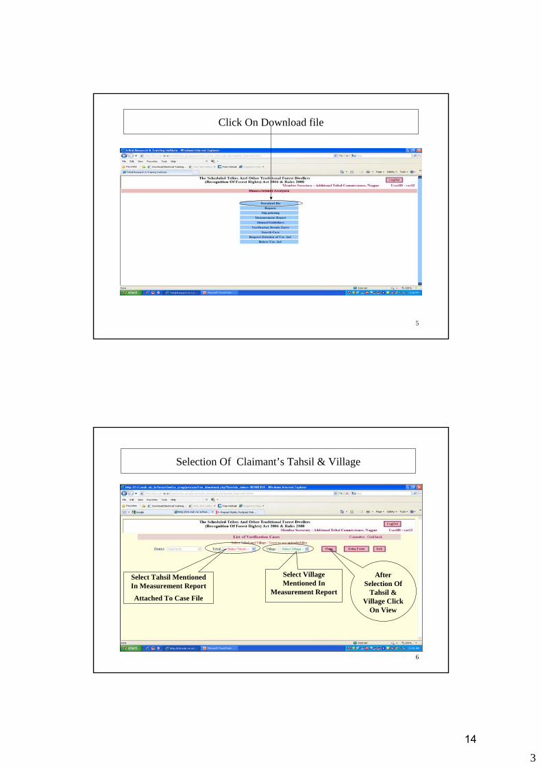
Click On Download file
6
Selection Of Claimant’s Tahsil & Village
Select Tahsil Mentioned In Measurement Report
Attached To Case File
Select Village Mentioned In
Measurement Report
After Selection Of
Tahsil & Village Click
On View
14

4
7
To Select Tahsil, Click On Arrow Then Click On Tahsil Name
8
To Select Village, Click On Arrow Then Click On Village Name
While Selecting Village Please Check The Village Code Mentioned Bracket
15

5
9
Click On View Button To View Claimant Data
10
Downloading Of Gpx File Step-1 (Claimant Selection)
Find Claimant Code Assigned To Claimant In Measurement Report Attached To Case File. To Download GPX file, Click on Download.
16

6
11
Downloading Of Gpx File Step-1.1 (Date Confirmation)
Enter Measurement Date Mentioned In Measurement Report
Enter Upload Date Mentioned In Measurement Report
12
Downloading Of Gpx File Step-1.2 (Date Confirmation)
After Entering The Upload Date, Measurement Date and Typing “yes” Click on OK to Start Download .gpx File
After Confirmation of Dates, Type “yes”
17

7
13
Downloading Of Gpx File Step-2 (Confirmation Of Download)
To Start Downloading Gpx File, Click On Download Button
14
Downloading Of Gpx File Step-3 (Saving Of GPX File)
To Save The Gpx File, Click On Save Button
18

8
15
Downloading Of Gpx File Step-4 (Drive Selection to Save GPX File)
Select Drive name containing ForestData_TRTI-VGIS folder & then select ForestData_TRTI-VGIS folder
16
Downloading Of Gpx File Step-5 (Folder Selection – For GPX File)
From ForestData_TRTI-VGIS Folder select folder GPX_SHP_JPG_Files
19

9
17
Downloading Of Gpx File Step-6 (Selection Of District Folder)
Select Folder with District Name (In Our Case Gadchiroli District)
18
Downloading Of Gpx File Step-7 (Tahsil Folder)
• While first time downloading data pertaining to a particular tahsil, you will require to create the folder for that tahsil.• Then you must select that tahsil to create folders with village code
• Latter on you must select the same folder to store the data pertaining to village from the same tahsil
20

10
19
Downloading Of Gpx File Step-7 (Creation Of Tahsil Folder)
Click Here to Create New folder
20
Downloading Of Gpx File Step-7 (Renaming Of New Folder)
Click On The New Folder, Type Tahsil Name,(In Our case Etapalli) & Double Click On It
21
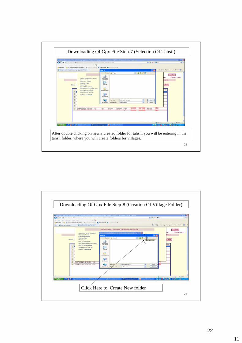
11
21
Downloading Of Gpx File Step-7 (Selection Of Tahsil)
After double clicking on newly created folder for tahsil, you will be entering in the tahsil folder, where you will create folders for villages.
22
Downloading Of Gpx File Step-8 (Creation Of Village Folder)
Click Here to Create New folder
22

12
23
Downloading Of Gpx File Step-8 (Renaming Of New Folder)
Click On The New Folder, Type Village Code (In our case Kas01)
24
Downloading Of Gpx File Step-8 (Selection Of Village Folder)
Double Click On Folder To Select Folder with Village Code
23

13
25
Downloading Of Gpx File Step-9
After Selecting Folder with Village Code, Click On save button
26
Downloading Of Gpx File Step-13
After download completes, click on close button
24

14
27
Completion Of Downloading Gpx File Step-14
Click On Exit button
28
Date Of Downloading Gpx File
By Clicking On Column Heading Column content can be arrange in ascending/ descending order
Download Date will be shown in Download Dt column
25
15
29
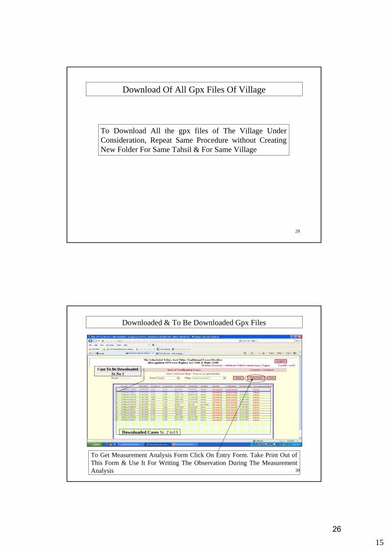
Download Of All Gpx Files Of Village
To Download All the gpx files of The Village Under Consideration, Repeat Same Procedure without Creating New Folder For Same Tahsil & For Same Village
30
Downloaded & To Be Downloaded Gpx Files
Downloaded Cases Sr. 2 to13
Case To Be Downloaded Sr.No 1
To Get Measurement Analysis Form Click On Entry Form. Take Print Out of This Form & Use It For Writing The Observation During The Measurement Analysis
26

16
31
Form For Measurement Analysis
27

Forest Rights Act - 2006Village Level Measurement Analysis Report - Form - III
List of Downloaded .gpx Files for Measurement AnalysisState : Maharashtra District : Pune Tehsil : Pune City Village : Pune (CB) (Code : Pun00)
I) GPX File Analysis Using MapSource Software II) GPS Output Analysis Using TRTI-VGIS Software1.Multiple Polygon or Multiple Tracks 1.Road/River/Stream Passes Through Measured Area2.Difference In Track & GPX File Name 2.Adjoining/Surrounding Forest Is Covered3.Widely Open or Wrongly Closed Polygon 3.Change In Vegetation Cover (2005-2006) & (2007-2008)4.Others (Pl Mention) 4.Overlapping Boundaries Of Adjoining Polygons
5.Others (Pl Mention)
Sr Claimant Name Date Of Area & I) GPX File Analysis II) GPS Output Analysis No. CaseID,Claimant Type,Claim Type Measurement Unit Using MapSource Software Using TRTI-VGIS Software
& Download by GPS Verification Dt Area(Sq. Mtr) 1 2 3 4 1 2 3 4 51 Jayant Sakharam Unde 21/12/2009 90.000 NA NA NA NA NA NA NA
2508PUN00jsu0, Tribal,Individual 21/12/2009 Sq. mtrArea calculated not by GPS Not By GPS
2 Jayant Sakharam Unde 21/12/2009 500.0002508PUN00jsu1, Tribal,Individual 21/12/2009 Sq. mtr
FRA Date : 21/12/2009 Page 1/1 28

1
1
GPX File Analysis Using MapSource SoftwareClick On Start-->Program-->Garmin
Click On MapSource
2
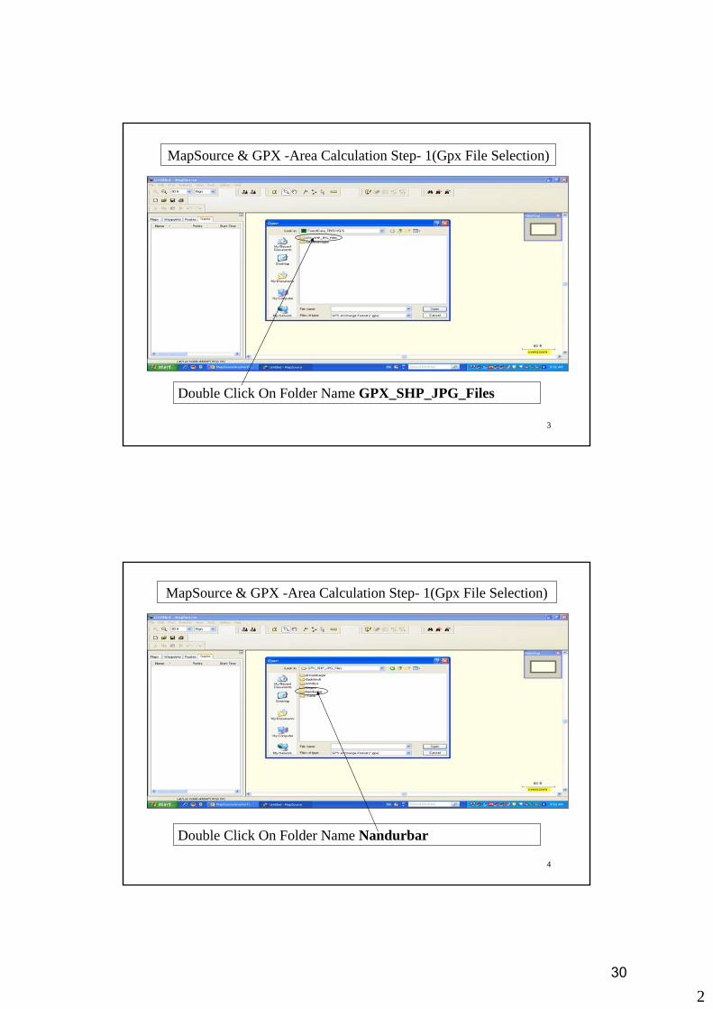
MapSource & GPX -Area Calculation Step-1(Gpx File Selection)
Click On File Menu & Then Click On Open Sub Menu
29
2
3
MapSource & GPX -Area Calculation Step- 1(Gpx File Selection)
Double Click On Folder Name GPX_SHP_JPG_Files
4
MapSource & GPX -Area Calculation Step- 1(Gpx File Selection)
Double Click On Folder Name Nandurbar
30

3
5
MapSource & GPX -Area Calculation Step- 1(Gpx File Selection)
Double Click On Folder Name Akkalkuwa
6
MapSource & GPX -Area Calculation Step- 1(Gpx File Selection)
Double Click On Folder Name Ama02
31

4
7
MapSource & GPX -Area Calculation Step- 1(Gpx File Selection)
If Gpx files are not listed then Click On Down Arrow
8
MapSource & GPX -Area Calculation Step- 1(Gpx File Selection)
From List Of File Type Select GPS eXchange Format (*.gpx)
32
5
9
MapSource & GPX -Area Calculation Step- 1(Gpx File Selection)
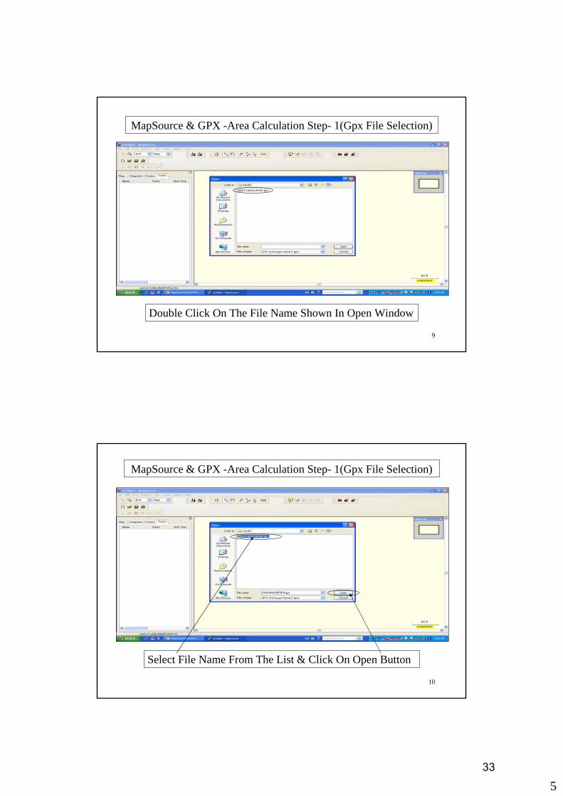
Double Click On The File Name Shown In Open Window
10
MapSource & GPX -Area Calculation Step- 1(Gpx File Selection)
Select File Name From The List & Click On Open Button
33

6
11
MapSource & GPX –No. Of Tracks Verification Step- 2
Track From The Selected File Will Be Shown
1. Each File Should Contain Only One Track. In Measurement Analysis Form In Column 1 Write No.2. If More Than One Tracks Are Shown, Then The Gpx File Is Faulty And Should Be Rejected. In Measurement Analysis Form In Column 1 Write Yes.
12
MapSource & GPX –Trackname & File Name Checking Step- 3
Select Track From Track List By Double Clicking On Track Name
34

7
13
MapSource & GPX –Trackname & File Name Checking Step- 3
Pl. Check Whether Track Name & File Names Are Different? If yes In Measurement Analysis Form In Column 2 Write Yes. Else Write No
Check For Correctness Of Both Codes (They Should Be Same)
Copy this code by pressing Control+C
If, Codes are not same,
reject the gpx file
14
MapSource & GPX -Area Calculation Step- 4
In Measurement Analysis Form, In Column For Area Write Area & Date Of Verification. & Click On Show On Map
35
8
15
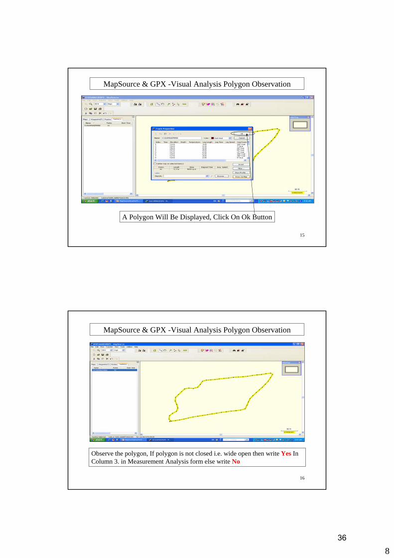
MapSource & GPX -Visual Analysis Polygon Observation
A Polygon Will Be Displayed, Click On Ok Button
16
MapSource & GPX -Visual Analysis Polygon Observation
Observe the polygon, If polygon is not closed i.e. wide open then write Yes In Column 3. in Measurement Analysis form else write No
36

9
17
MapSource & GPX -Visual Analysis-Google Earth
Click On View Menu
18
MapSource & GPX -Visual Analysis-Google Earth
Click On View In Google Earth
37

10
19
MapSource & GPX -Visual Analysis-Google Earth
Google Earth Software Will Start
20
Google Earth (Visual Analysis)
Click On + Symbol Shown Before Checkmark Of MapSource
38

11
21
Google Earth (Visual Analysis)
Uncheck On Checkmark Before Waypoints Under MapSource
22
Google Earth (Visual Analysis)
Click On + Sign Before Tracks Under MapSource
39

12
23
Google Earth (Visual Analysis)
Uncheck On Checkmark Before Points Under Tracks
24
Google Earth (Visual Analysis)
Click On Path Then, Right Click On Path And Select Properties
40

13
25
Google Earth (Visual Analysis)
Click On Style Colour Tab
26
Google Earth (Visual Analysis)
Change Colour Width to 2.0
41

14
27
Google Earth (Visual Analysis)
Change Opacity To 60%
28
Google Earth (Visual Analysis)
42

15
29
Google Earth -Visual Analysis- Image Saving-1
2.Click On
Save
3. Click On Save Image
1.Click On File
30
Google Earth -Visual Analysis- Image Saving-2
Select Village Folder As Destination Folder
43

16
31
Google Earth -Visual Analysis- Image Saving-3
Paste The Claimant Code Which You Have Already Copied From Track Name In Mapsource. Suffix The Code With word google and click on Save
44

1
1
GPX Files & Satellite Image Analysis Using TRTI-VGIS Software
2
Selection Of District
Select District From The List Of District
45

2
3
Select District & Click On Ok
4
Main Screen Of TRTI-VGIS Software
46

3
5
Addition Of GPX File
Click On Add Option, Then From Sub-Menu Select Add Gpx File
6
Selection Of Folders & Downloaded GPX File
Select Drive name containing ForestData_TRTI-VGIS folder & then select ForestData_TRTI-VGIS folder Continue Folder Selection Till You Reach At Desired Village Code
47
4
7
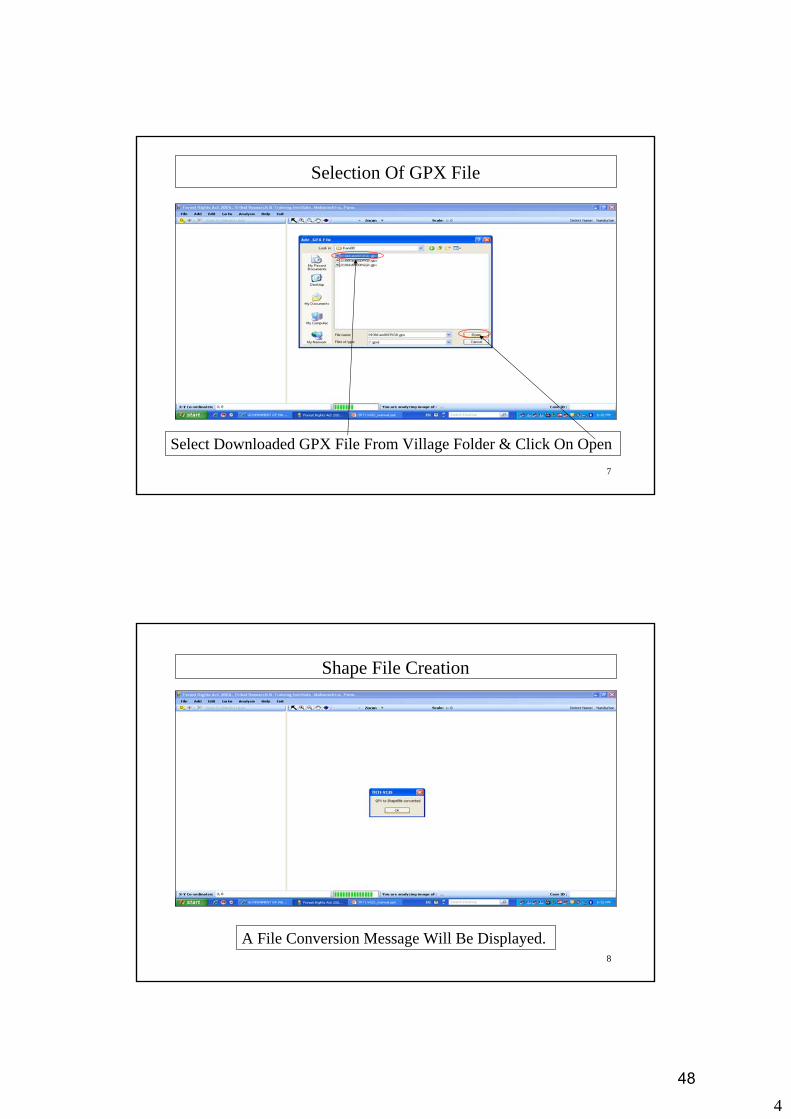
Selection Of GPX File
Select Downloaded GPX File From Village Folder & Click On Open
8
Shape File Creation
A File Conversion Message Will Be Displayed.
48
5
9
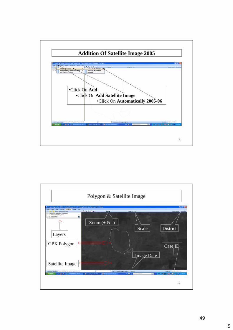
Addition Of Satellite Image 2005
•Click On Add•Click On Add Satellite Image
•Click On Automatically 2005-06
10
Polygon & Satellite Image
Layers
Satellite Image
GPX Polygon
Scale
Image Date
District
Case ID
Zoom (+ & -)
49

6
11
Land Analysis Close View 2005 Year
Click On Analysis
Move Cursor On Analyze
Displayed Map
Click On Close View Of The Area
Click On Analysis
Move Cursor On Analyze
Displayed Map
Click On Close View Of The Area
12
Land Analysis Photo Process 2005 Year
Adjust Image Brightness By Scrolling & Then Click On Save Final Map
Brightness Scroll Bar Save Photo
50

7
13
Photo Creation Close View 2005
After Carefully Observing The Path Of Image Stored, Click On Ok & Then Click On ExitIf Brightness Of Image Is Not At acceptable level, adjust the brightness & Click On Save Final Map
Image Attributes
14
Satellite Image Addition 2007 Year
•Click On Add•Click On Add Satellite Image
•Click On Automatically 2007-08
51

8
15
Land Analysis Close View 2007 Year
Click On Analysis
Move Cursor On Analyze
Displayed Map
Click On Close View Of The Area
16
Land Analysis Photo Process 2007 Year
Brightness Scroll Bar Save Photo
Adjust Image Brightness By Scrolling & Then Click On Save Final Map
52
9
17
Photo Creation Close View 2007
After Carefully Observing The Path Of Image Stored, Click On Ok & Then Click On ExitIf Brightness Of Image Is Not At acceptable level, adjust the brightness & Click On Save Final Map
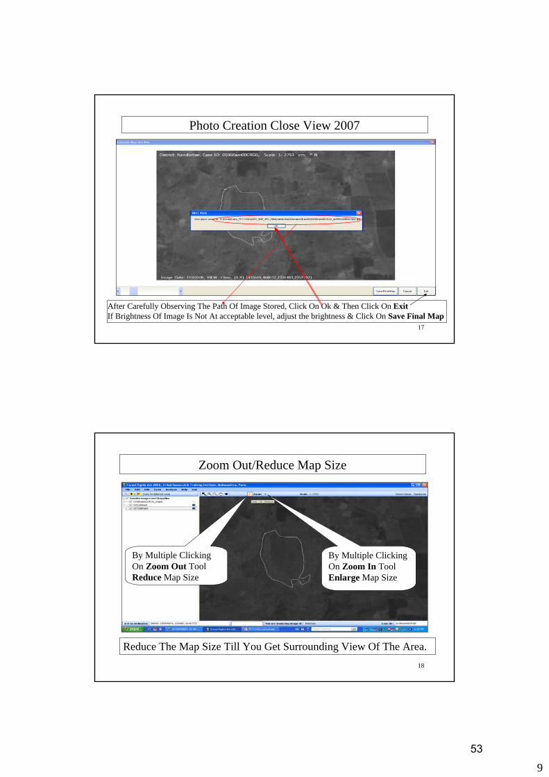
18
Zoom Out/Reduce Map Size
Reduce The Map Size Till You Get Surrounding View Of The Area.
By Multiple Clicking On Zoom Out Tool Reduce Map Size
By Multiple Clicking On Zoom In Tool Enlarge Map Size
53

10
19
Surroundings View 2007
Click On Analysis
Move Cursor On Analyze
Displayed Map
Click On Surrounding View
Of The Area
20
Land Analysis Photo Process 2007 Year
Adjust Image Brightness By Scrolling & Then Click On Save Final Map
Brightness Scroll Bar Save Photo
54
11
21
Photo Creation Surrounding View 2007
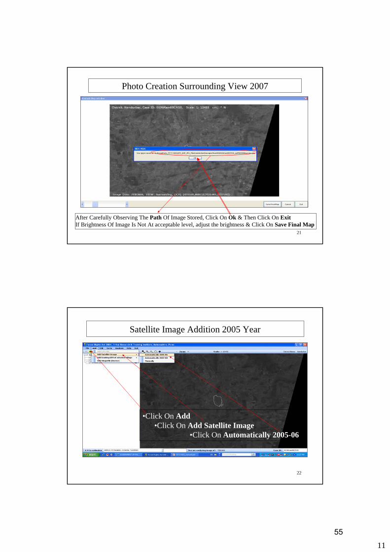
After Carefully Observing The Path Of Image Stored, Click On Ok & Then Click On ExitIf Brightness Of Image Is Not At acceptable level, adjust the brightness & Click On Save Final Map
22
Satellite Image Addition 2005 Year
•Click On Add•Click On Add Satellite Image
•Click On Automatically 2005-06
55

12
23
Surroundings View 2005
Click On Analysis
Move Cursor On Analyze
Displayed Map
Click On Surrounding View
Of The Area
24
Land Analysis Photo Process 2005 Year
Adjust Image Brightness By Scrolling & Then Click On Save Final Map
Brightness Scroll Bar Save Photo
56

13
25
Photo Creation Surrounding View 2005
After Carefully Observing The Path Of Image Stored, Click On Ok & Then Click On ExitIf Brightness Of Image Is Not At acceptable level, adjust the brightness & Click On Save Final Map
26
Add Existing Village Ploygon
•Click On Add•Click On Add Existing GPX Of Selected Village
•Click On Path Of Selected Village
57

14
27
Village Level Report View 2005 OR 2007
Click On Analysis
Move Cursor On Analyze
Displayed Map
Click On Village Level Report View
28
Village Level Land Analysis Photo Process 2005 OR 2007Year
Adjust Image Brightness By Scrolling & Then Click On Save Final Map
58

15
29
Photo Creation Village Level Report 2005 OR 2007
After Carefully Observing The Path Of Image Stored, Click On Ok & Then Click On ExitIf Brightness Of Image Is Not At acceptable level, adjust the brightness & Click On Save Final Map
30
Output From TRTI-VGIS
• Photos Of GPX Polygon Using Satellite images of the year 2005-06 And 2007-08
Close View (2 Photos)Surrounding View (2 Photos)
• Verification Of Style GPX Polygon Proper Shaped PolygonNon Intersecting Polygons (1 Photo)
59
1
1
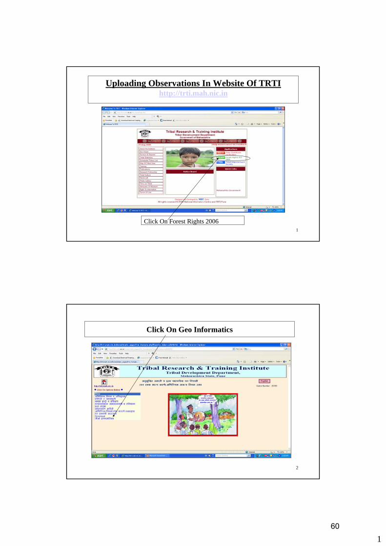
Uploading Observations In Website Of TRTIhttp://trti.mah.nic.in
Click On Forest Rights 2006
2
Click On Geo Informatics
60

2
3
Click On Login
4
Type Login Id & Password in Login Details and click on sign in
61

3
5
Click On Verification Details Entry
6
Enter 13 Digits Code & Click On Show Button
62
4
7
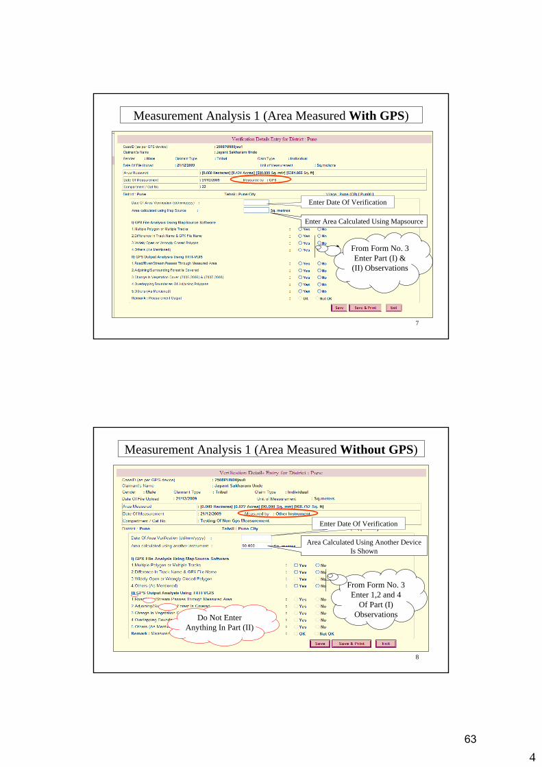
Measurement Analysis 1 (Area Measured With GPS)
Enter Date Of Verification
Enter Area Calculated Using Mapsource
From Form No. 3 Enter Part (I) &
(II) Observations
8
Measurement Analysis 1 (Area Measured Without GPS)
Enter Date Of Verification
Area Calculated Using Another Device Is Shown
From Form No. 3 Enter 1,2 and 4
Of Part (I) ObservationsDo Not Enter
Anything In Part (II)
63

5
9
Measurement Analysis Details 2
After Entering The Details & If Verification Slip To Printed Latter, Click Here. Confirmation Screen Will Appear
After Entering The Details & If
Immediately Needs Printout of Verification Slip Then Click Here. Confirmation Screen
Will Appear
Click Here To Exit Without Saving.
10
Measurement Analysis Details 3
Please Confirm The Observations And Click All The Checkboxes. If All Are Correct, Enter yes In Textbox And Click On Ok Else Click On No, Previous Form Will Appear To Facilitate Corrections.
64

6
11
Measurement Analysis Details 4
Confirmation Of Saving The Data Will Be Shown. Click Ok To Continue
12
Measurement Analysis Slip 1
Click On Save button
65

7
13
Measurement Analysis Slip 2
Select Village Folder As Destination Folder
14
Measurement Analysis Slip 3
Click On Open
66

8
15
Measurement Analysis Slip (Area Measured With GPS)
16
Measurement Analysis Slip (Area Measured Without GPS)
67

The Scheduled Tribes And Other Traditional Forest Dwellers (Recognition Of Forest Rights) Act 2006 & Rules 2008
Measurement Analysis SlipDistrict Level Verification Committee for District : Gadchiroli
1. Claimant's Code : 1209Kas01DJN0 2. GPX File Name : 1209Kas01DJN0.gpx
3. Claimant's Name : Dasodhar Jogi Narote
4. Claimant's Gender : Male 5. Claimant Type : Tribal
6. Claim Type : Individual
7. Details of Land measured by GPS
7.1 Date of Measurement : 26/05/2009 7.2 Date of .gpx file upload : 22/08/2009
7.3 Compartment/Gat/Survey No. : 29
7.4 Village : Kasansur [ Kas01 ] Tehsil : Etapalli District : Gadchiroli
7.5 Area : [0.769 Hectares] [1.900 Acres] [7689.026 Sq. mtr] [82764.000 Sq. ft]
7.5 A Unit used by GPS machine : Acre
7.6 Shape of the land measured (Polygon)
FRA Date : 24/10/2009 Page 1/2 68

Claimant's Code : 1209Kas01DJN0 Claimant's Name : Dasodhar Jogi Narote
Verification Details
1. Date of Area Verification Using Software : 24/10/2009
I) GPX File Analysis Using MapSource Software
1.Multiple Polygon or Multiple Tracks : No
2.Difference In Track Name & GPX File Name : No
3.Widely Open or Wrongly Closed Polygon : No
4.Others (As Mentioned) : No
II) GPS Output Analysis Using TRTI-VGIS
1.Road/River/Stream Passes Through Measured Area : No
2.Adjoining/Surrounding Forest Is Covered : No
3.Change In Vegetation Cover (2005-2006) & (2007-2008) : No
4.Overlapping Boundaries Of Adjoining Polygons : No
5.Others (As Mentioned) : No
Remark : Measurement Output : OK
Area calculated Using MapSource Software : [7613.000 Sq. mtr]
Area Converted in Units Shown : [0.761 Hectares] [1.881 Acres][81945.647 Sq. ft]
(Signature with date)Name : Verification Unit Incharge : Designation : Office Name :
FRA Date : 24/10/2009 Page 2/2 69

The Scheduled Tribes And Other Traditional Forest Dwellers (Recognition Of Forest Rights) Act 2006 & Rules 2008
Measurement Analysis SlipDistrict Level Verification Committee for District : Pune
1. Claimant's Code : 2508PUN00jsu0 2. GPX File Name : 2508PUN00jsu0.gpx
3. Claimant's Name : Jayant Sakharam Unde
4. Claimant's Gender : Male 5. Claimant Type : Tribal
6. Claim Type : Individual
7. Details of Land measured
7.1 Date of Measurement : 21/12/2009 7.2 Date of .gpx file upload : 21/12/2009
7.3 Compartment/Gat/Survey No. : Testing Of Non Gps Measurement
7.4 Village : Pune (CB) [ Pun00 ] Tehsil : Pune City District : Pune
7.5 Area : [0.009 Hectares] [0.022 Acres] [90.000 Sq. mtr] [968.752 Sq. ft]
7.5 A Area being too small - measured separately by another instrument
7.5 B Unit of Measurement : Sq.mtr
7.6 The mark below is GPS location detail for very small plot
FRA Date : 21/12/2009 Page 1/2 70

Claimant's Code : 2508PUN00jsu0 Claimant's Name : Jayant Sakharam Unde
Verification Details
1. Date of Area Verification Using Software : 21/12/2009
I) GPX File Analysis Using MapSource Software
1.Multiple Polygon or Multiple Tracks : No
2.Difference In Track Name & GPX File Name : No
3.Widely Open or Wrongly Closed Polygon : Not Applicable
4.Others (As Mentioned) : No
II) GPS Output Analysis Using TRTI-VGIS
1.Road/River/Stream Passes Through Measured Area : Not Applicable
2.Adjoining/Surrounding Forest Is Covered : Not Applicable
3.Change In Vegetation Cover (2005-2006) & (2007-2008) : Not Applicable
4.Overlapping Boundaries Of Adjoining Polygons : Not Applicable
5.Others (As Mentioned) : Not Applicable
Remark : Measurement Output : OK
Area being too small - measured separately by another instrument Unit of Measurement : Sq.mtr
Area Measured by another instrument : 90.000 Sq.mtr
Area Converted in Units Shown : [0.009 Hectares] [0.022 Acres][968.752 Sq. ft]
(Signature with date)Name : Verification Unit Incharge : Designation : Office Name :
FRA Date : 21/12/2009 Page 2/2 71

1
1
Installation- MapSource
• Open ‘Installers_TRTI-VGIS’ folder from DVD or Local Drive• Select and Open folder Named As ‘Map_source’• Select And Run “Setup.exe”• You Will See Screen Below
Click here to continue
2
Installation- MapSource
1. Select this box
2. Click Next
Click Next
Wait for 1-2 min
2. Click Done
1. Select this box
72

2
3
Installation-MapWinGIS47
• Open ‘Installers_TRTI-VGIS’ folder from DVD or Local Drive• Select and run “MapWinGIS47RC2-x86-Setup”• You will see Screens Below
Click Next
4
Installation-MapWinGIS47
2. Click Next
1. Select this box
Click Finish
Click Install
Wait for 1-2 min
73
3
5
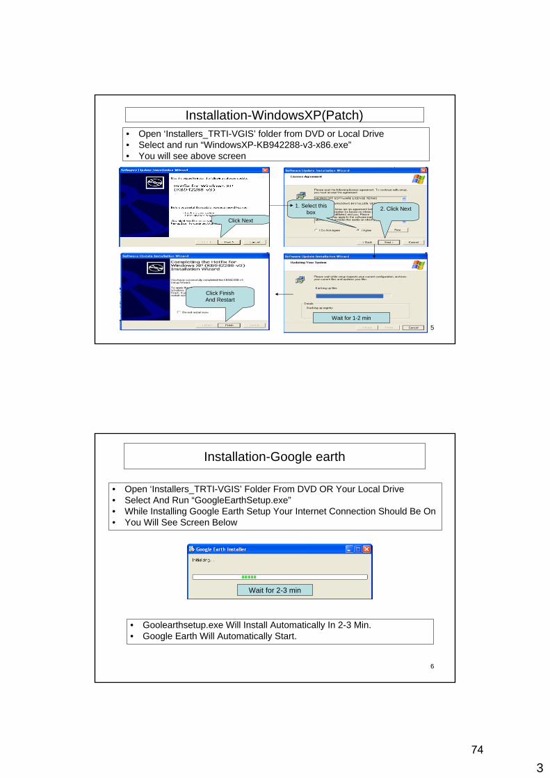
Installation-WindowsXP(Patch)• Open ‘Installers_TRTI-VGIS’ folder from DVD or Local Drive• Select and run “WindowsXP-KB942288-v3-x86.exe”• You will see above screen
2. Click Next1. Select this box
Wait for 1-2 min
Click Next
Click FinishAnd Restart
6
Installation-Google earth
• Open ‘Installers_TRTI-VGIS’ Folder From DVD OR Your Local Drive• Select And Run “GoogleEarthSetup.exe”• While Installing Google Earth Setup Your Internet Connection Should Be On• You Will See Screen Below
Wait for 2-3 min
• Goolearthsetup.exe Will Install Automatically In 2-3 Min.• Google Earth Will Automatically Start.
74

4
7
Installation-Net Framework
• Open ‘Installers_TRTI-VGIS’ folder from DVD or Local Drive
• Select And Run “NetFx20SP2_x86.exe”• You Will See Installation Screen
75

1
1
MapSource ConfigurationClick On Start-->Program-->Garmin
Click On MapSource
2
MapSource Software Configuration Step-1
Click On Edit
76

2
3
MapSource Software Configuration Step-2
Click On Preferences
4
MapSource Software Configuration Step-3
Select Unit Tab Shown In Preference Window
77

3
5
MapSource Software Configuration Step-4(Area Selection)
From Area Options, Select Square Meters, Square Kilometers
6
MapSource Software Configuration Step-5 (Position Selection)
Select Position Tab Shown In Preference Window
78
4
7
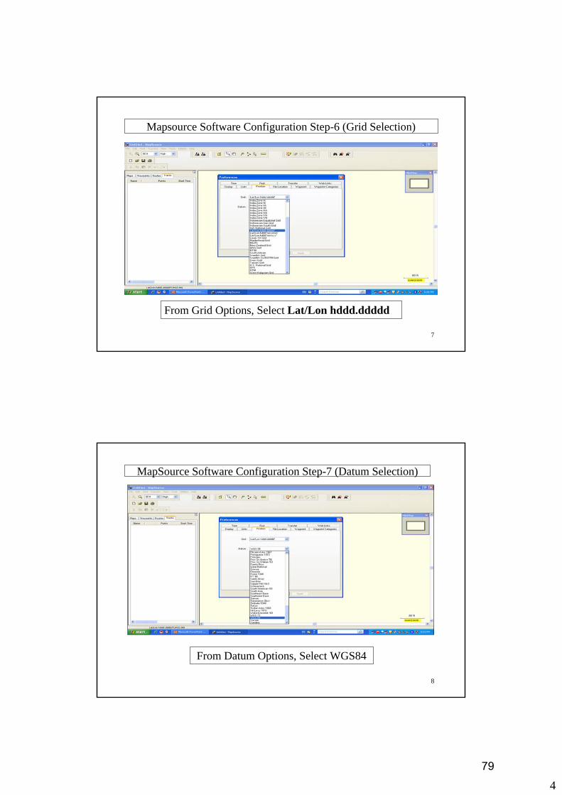
Mapsource Software Configuration Step-6 (Grid Selection)
From Grid Options, Select Lat/Lon hddd.ddddd
8
MapSource Software Configuration Step-7 (Datum Selection)
From Datum Options, Select WGS84
79

5
9
MapSource Software Configuration Step-8 (File Location)
Select File Location Tab Shown In Preference Window Then Click On Browse
10
MapSource Software Configuration Step-9 (Drive Selection)
Select Drive name containing ForestData_TRTI-VGIS folder & then select ForestData_TRTI-VGIS folder
80
6
11
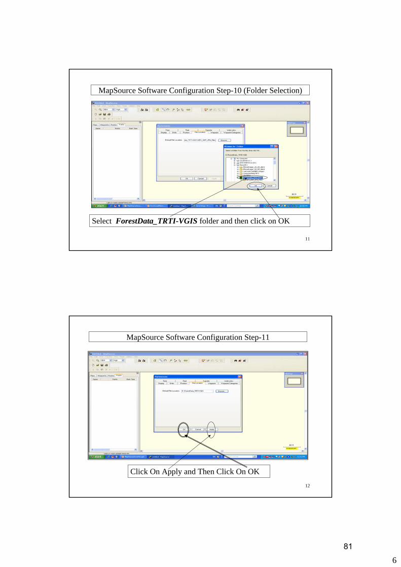
MapSource Software Configuration Step-10 (Folder Selection)
Select ForestData_TRTI-VGIS folder and then click on OK
12
MapSource Software Configuration Step-11
Click On Apply and Then Click On OK
81

7
13
MapSource Software Configuration Step-12 (Software Updation )
Click On Help and Then Click On Check For Software Update
14
MapSource Software Configuration Step-13(Software Updation)
82

8
15
MapSource Software Configuration Step-14 (Software Updation)
Click On Ok
16
MapSource Software Configuration Step-15
Click On File and Then Click On Exit
83
1
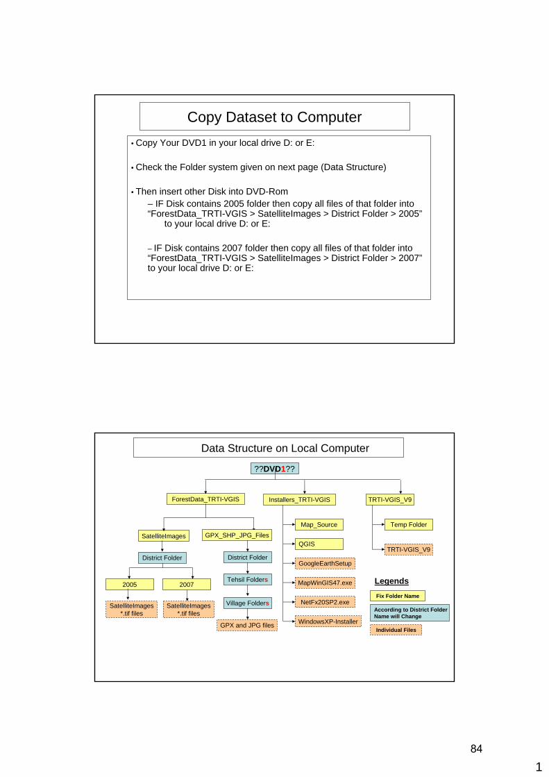
Copy Dataset to Computer• Copy Your DVD1 in your local drive D: or E:
• Check the Folder system given on next page (Data Structure)
• Then insert other Disk into DVD-Rom– IF Disk contains 2005 folder then copy all files of that folder into “ForestData_TRTI-VGIS > SatelliteImages > District Folder > 2005”
to your local drive D: or E:
– IF Disk contains 2007 folder then copy all files of that folder into “ForestData_TRTI-VGIS > SatelliteImages > District Folder > 2007”to your local drive D: or E:
Data Structure on Local Computer
??DVD1??
ForestData_TRTI-VGIS Installers_TRTI-VGIS TRTI-VGIS_V9
District Folder
Tehsil Folders
SatelliteImages
2005 2007
GPX_SHP_JPG_Files
District Folder
Map_Source
QGIS
GoogleEarthSetup
MapWinGIS47.exe
NetFx20SP2.exeVillage Folders
Temp Folder
TRTI-VGIS_V9
WindowsXP-Installer
SatelliteImages*.tif files
GPX and JPG files
Fix Folder Name
Individual Files
Legends
According to District Folder Name will Change
SatelliteImages*.tif files
84