users are doing it for themselves: pedestrian navigation
TRANSCRIPT

Users aredoing it forthemselves
HaraldHolone,Gunnar
Misund andHakon
Holmstedt
Agenda
Introduction
Systemdescription
Experiments
Conclusions
Users are doing it for themselves: PedestrianNavigation with User Generated Content
Harald Holone, Gunnar Misund and Hakon Holmstedt
Østfold University College, Halden, Norway
2007-09-13

Users aredoing it forthemselves
HaraldHolone,Gunnar
Misund andHakon
Holmstedt
Agenda
Introduction
Systemdescription
Experiments
Conclusions
Outline
1 Introduction
2 System description
3 Experiments
4 Conclusions

Users aredoing it forthemselves
HaraldHolone,Gunnar
Misund andHakon
Holmstedt
Agenda
Introduction
Systemdescription
Experiments
Conclusions
Abstract
OurWay is a mobile route planning system based on userfeedback.
The users can give feedback on route quality in the field -there and then.
Collaboration between users in the form of sharedexperiences.
We’re reporting from the initial round of experiments,validating the concept.
The results are encouraging.

Users aredoing it forthemselves
HaraldHolone,Gunnar
Misund andHakon
Holmstedt
Agenda
Introduction
Systemdescription
Experiments
Conclusions
About MAG / Østfold University College
Halden is a town south-east in Norway.
Our faculty of computer science traditionally has apractical and technology oriented focus.
Over the last years, HCI and other forms ofuser-orientation has become increasingly important to us.
The Mobile Applications Group (MAG) is a cross-diciplinegroup with a common focus on mobile applications.
Our master program on mobile applications started in2003.

Users aredoing it forthemselves
HaraldHolone,Gunnar
Misund andHakon
Holmstedt
Agenda
Introduction
Systemdescription
Experiments
Conclusions
Research motivation
User generated content is prevalent on the net today.
Wikipedia.orgYouTubeMySpaceFlickr. . . and loads of others.
Not to mention the plethora of blogs, podcasts and opensource software.
Further, route planning for pedestrians is quite differentfrom route planning for car drivers.

Users aredoing it forthemselves
HaraldHolone,Gunnar
Misund andHakon
Holmstedt
Agenda
Introduction
Systemdescription
Experiments
Conclusions
MAG and geodata
Experience from various aspects of geodata treatment.
Integration of heterogeneous geodata sources.3D-models (worlds, cities, sea floor)Ontology building, metadata standards.
During work on Location BasedServices, discoveredOpenStreetMap, a wiki worldmap.

Users aredoing it forthemselves
HaraldHolone,Gunnar
Misund andHakon
Holmstedt
Agenda
Introduction
Systemdescription
Experiments
Conclusions
Map making: Field work
Proprietary OpenStreetMap
Users aredoing it forthemselves
HaraldHolone,Gunnar
Misund andHakon
Holmstedt
Agenda
Introduction
Systemdescription
Experiments
Conclusions
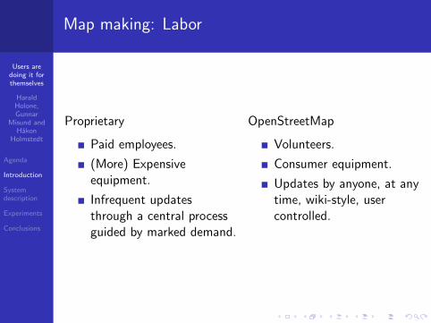
Map making: Labor
Proprietary
Paid employees.
(More) Expensiveequipment.
Infrequent updatesthrough a central processguided by marked demand.
OpenStreetMap
Volunteers.
Consumer equipment.
Updates by anyone, at anytime, wiki-style, usercontrolled.

Users aredoing it forthemselves
HaraldHolone,Gunnar
Misund andHakon
Holmstedt
Agenda
Introduction
Systemdescription
Experiments
Conclusions
Map making: Results
Proprietary OpenStreetMap

Users aredoing it forthemselves
HaraldHolone,Gunnar
Misund andHakon
Holmstedt
Agenda
Introduction
Systemdescription
Experiments
Conclusions
Having the data
. . . and with OSM, the data isavailable under the CreativeCommons Attribution-ShareAlikelicense.
Now, back to the issue of pedestrian route finding . . .
First, a brief review of two related projects.

Users aredoing it forthemselves
HaraldHolone,Gunnar
Misund andHakon
Holmstedt
Agenda
Introduction
Systemdescription
Experiments
Conclusions
A complex approach
MAGUS (Modeling Access with GIS in Urban Systems)
Aims to assist new users and enable better navigation forexisting users, and to be a means for planners.
Based on a comprehensive level-of-service (LOS) model forwheelchair users, gathered using questionnaires,interviews, observations, and physical measurements.
Three types of wheelchairs, ten levels of user fitness.
13 environment parameters in use, e.g. surface type,quality, and steps.
Shortest path calculation based on impedance, computedby complex heuristics.
Proprietary software, complex and expensive GIS system.

Users aredoing it forthemselves
HaraldHolone,Gunnar
Misund andHakon
Holmstedt
Agenda
Introduction
Systemdescription
Experiments
Conclusions
A simpler approach
U-ACCESS (Universal Access)
Used for planning purposes, campus routes, for pedestrianswith varying levels of mobility.
Based on a simpler data model than MAGUS.
Three types of pedestrians: ambulatory, walking aid, andwheelchair.
11 environment parameters in use, e.g. curb buts, ramps,and sidewalks.
Creates three separate networks based on accessibilityvariables and uses Dijkstra for route findings.
Data acquisition and processing using expensive,proprietary software. Web-based client for the users.
Users aredoing it forthemselves
HaraldHolone,Gunnar
Misund andHakon
Holmstedt
Agenda
Introduction
Systemdescription
Experiments
Conclusions
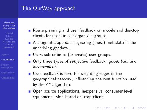
The OurWay approach
Route planning and user feedback on mobile and desktopclients for users in self-organized groups.
A pragmatic approach, ignoring (most) metadata in theunderlying geodata.
Users subscribe to (or create) user groups.
Only three types of subjective feedback: good, bad, andinconvenient.
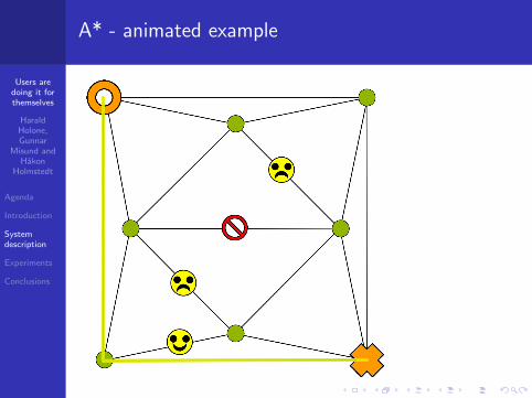
User feedback is used for weighting edges in thegeographical network, influencing the cost function usedby the A* algorithm.
Open source applications, inexpensive, consumer levelequipment. Mobile and desktop client.

Users aredoing it forthemselves
HaraldHolone,Gunnar
Misund andHakon
Holmstedt
Agenda
Introduction
Systemdescription
Experiments
Conclusions
OurWay architecture overview

Users aredoing it forthemselves
HaraldHolone,Gunnar
Misund andHakon
Holmstedt
Agenda
Introduction
Systemdescription
Experiments
Conclusions
Clients
The main client is a mobile phone with a GPS attached.
Mobile IP to server over UMTS / GPRS.
A desktop client (port of the mobile application) for labtrials.
The client presents a map image, and allows the user toquery for a route between two given points.
The suggested route is presented on the client map.
The user can provide feedback whilst following a route:good, bad or inconvenient.

Users aredoing it forthemselves
HaraldHolone,Gunnar
Misund andHakon
Holmstedt
Agenda
Introduction
Systemdescription
Experiments
Conclusions
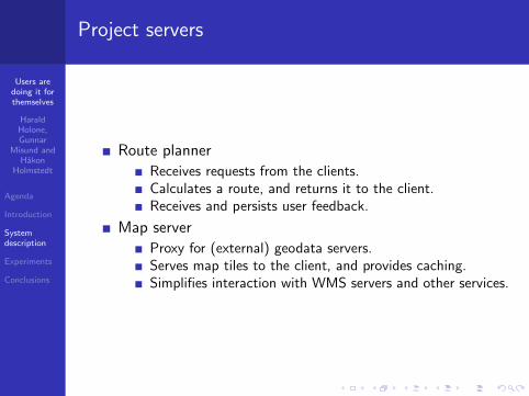
Project servers
Route planner
Receives requests from the clients.Calculates a route, and returns it to the client.Receives and persists user feedback.
Map server
Proxy for (external) geodata servers.Serves map tiles to the client, and provides caching.Simplifies interaction with WMS servers and other services.
Users aredoing it forthemselves
HaraldHolone,Gunnar
Misund andHakon
Holmstedt
Agenda
Introduction
Systemdescription
Experiments
Conclusions
Project servers
Route planner
Receives requests from the clients.Calculates a route, and returns it to the client.Receives and persists user feedback.
Map server
Proxy for (external) geodata servers.Serves map tiles to the client, and provides caching.Simplifies interaction with WMS servers and other services.

Users aredoing it forthemselves
HaraldHolone,Gunnar
Misund andHakon
Holmstedt
Agenda
Introduction
Systemdescription
Experiments
Conclusions
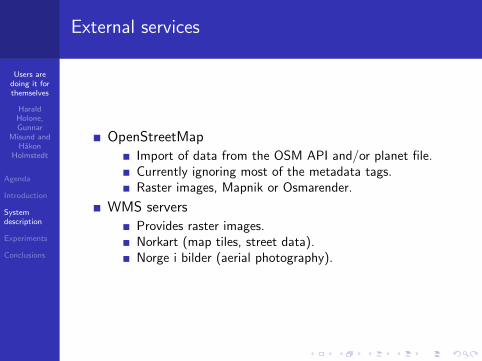
External services
OpenStreetMap
Import of data from the OSM API and/or planet file.Currently ignoring most of the metadata tags.Raster images, Mapnik or Osmarender.
WMS servers
Provides raster images.Norkart (map tiles, street data).Norge i bilder (aerial photography).
Users aredoing it forthemselves
HaraldHolone,Gunnar
Misund andHakon
Holmstedt
Agenda
Introduction
Systemdescription
Experiments
Conclusions
External services
OpenStreetMap
Import of data from the OSM API and/or planet file.Currently ignoring most of the metadata tags.Raster images, Mapnik or Osmarender.
WMS servers
Provides raster images.Norkart (map tiles, street data).Norge i bilder (aerial photography).

Users aredoing it forthemselves
HaraldHolone,Gunnar
Misund andHakon
Holmstedt
Agenda
Introduction
Systemdescription
Experiments
Conclusions
A* - animated example

Users aredoing it forthemselves
HaraldHolone,Gunnar
Misund andHakon
Holmstedt
Agenda
Introduction
Systemdescription
Experiments
Conclusions
A* - animated example

Users aredoing it forthemselves
HaraldHolone,Gunnar
Misund andHakon
Holmstedt
Agenda
Introduction
Systemdescription
Experiments
Conclusions
A* - animated example

Users aredoing it forthemselves
HaraldHolone,Gunnar
Misund andHakon
Holmstedt
Agenda
Introduction
Systemdescription
Experiments
Conclusions
A* - animated example

Users aredoing it forthemselves
HaraldHolone,Gunnar
Misund andHakon
Holmstedt
Agenda
Introduction
Systemdescription
Experiments
Conclusions
A* - animated example

Users aredoing it forthemselves
HaraldHolone,Gunnar
Misund andHakon
Holmstedt
Agenda
Introduction
Systemdescription
Experiments
Conclusions
A* - animated example

Users aredoing it forthemselves
HaraldHolone,Gunnar
Misund andHakon
Holmstedt
Agenda
Introduction
Systemdescription
Experiments
Conclusions
A* - animated example

Users aredoing it forthemselves
HaraldHolone,Gunnar
Misund andHakon
Holmstedt
Agenda
Introduction
Systemdescription
Experiments
Conclusions
A* - animated example

Users aredoing it forthemselves
HaraldHolone,Gunnar
Misund andHakon
Holmstedt
Agenda
Introduction
Systemdescription
Experiments
Conclusions
A* - animated example
Users aredoing it forthemselves
HaraldHolone,Gunnar
Misund andHakon
Holmstedt
Agenda
Introduction
Systemdescription
Experiments
Conclusions
A* - animated example

Users aredoing it forthemselves
HaraldHolone,Gunnar
Misund andHakon
Holmstedt
Agenda
Introduction
Systemdescription
Experiments
Conclusions
A* - animated example

Users aredoing it forthemselves
HaraldHolone,Gunnar
Misund andHakon
Holmstedt
Agenda
Introduction
Systemdescription
Experiments
Conclusions
A* - animated example

Users aredoing it forthemselves
HaraldHolone,Gunnar
Misund andHakon
Holmstedt
Agenda
Introduction
Systemdescription
Experiments
Conclusions
A* - animated example

Users aredoing it forthemselves
HaraldHolone,Gunnar
Misund andHakon
Holmstedt
Agenda
Introduction
Systemdescription
Experiments
Conclusions
Concept validation
Proof of concept, not full-blownuser study.
Baby strollers in Halden.
A handful of start/destinationsets.
Iterated on each of the sets untilthe routes converged.
Some iterations were done fromthe lab.

Users aredoing it forthemselves
HaraldHolone,Gunnar
Misund andHakon
Holmstedt
Agenda
Introduction
Systemdescription
Experiments
Conclusions
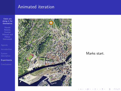
Animated iteration
User navigates toarea of interest,either assisted byexternal GPS ormanually by pan andzoom
Users aredoing it forthemselves
HaraldHolone,Gunnar
Misund andHakon
Holmstedt
Agenda
Introduction
Systemdescription
Experiments
Conclusions
Animated iteration
Marks start.

Users aredoing it forthemselves
HaraldHolone,Gunnar
Misund andHakon
Holmstedt
Agenda
Introduction
Systemdescription
Experiments
Conclusions
Animated iteration
Marks destination.

Users aredoing it forthemselves
HaraldHolone,Gunnar
Misund andHakon
Holmstedt
Agenda
Introduction
Systemdescription
Experiments
Conclusions
Animated iteration
System finds anddisplays shortestroute based ongeographic distancesof network edges.

Users aredoing it forthemselves
HaraldHolone,Gunnar
Misund andHakon
Holmstedt
Agenda
Introduction
Systemdescription
Experiments
Conclusions
Animated iteration
User encounters asteep stairwayleading to a narrowpedestrian bridge.

Users aredoing it forthemselves
HaraldHolone,Gunnar
Misund andHakon
Holmstedt
Agenda
Introduction
Systemdescription
Experiments
Conclusions
Animated iteration
User marks locationas inaccessible.

Users aredoing it forthemselves
HaraldHolone,Gunnar
Misund andHakon
Holmstedt
Agenda
Introduction
Systemdescription
Experiments
Conclusions
Animated iteration
System recalculatesshortest route basedon adjusted edgeweight.

Users aredoing it forthemselves
HaraldHolone,Gunnar
Misund andHakon
Holmstedt
Agenda
Introduction
Systemdescription
Experiments
Conclusions
Animated iteration
System recalculatesshortest route basedon adjusted edgeweight.

Users aredoing it forthemselves
HaraldHolone,Gunnar
Misund andHakon
Holmstedt
Agenda
Introduction
Systemdescription
Experiments
Conclusions
Animated iteration
User entering a dirtroad with bumps andvarious obstacles.

Users aredoing it forthemselves
HaraldHolone,Gunnar
Misund andHakon
Holmstedt
Agenda
Introduction
Systemdescription
Experiments
Conclusions
Animated iteration
User marks locationas uncomfortable.

Users aredoing it forthemselves
HaraldHolone,Gunnar
Misund andHakon
Holmstedt
Agenda
Introduction
Systemdescription
Experiments
Conclusions
Animated iteration
System suggestsalternative andacceptable route.

Users aredoing it forthemselves
HaraldHolone,Gunnar
Misund andHakon
Holmstedt
Agenda
Introduction
Systemdescription
Experiments
Conclusions
Animated iteration
System suggestsalternative andacceptable route.

Users aredoing it forthemselves
HaraldHolone,Gunnar
Misund andHakon
Holmstedt
Agenda
Introduction
Systemdescription
Experiments
Conclusions
Findings
The routes converged surprisingly quickly.
The rate is related to the homogeneity and lack ofobstacles in an area.
The penalty factor is low in an urban environment.
User generated geodata serves as a promising platform forinnovative Location Based Services.
Users are more likely to give negative feedback thanpositive feedback.

Users aredoing it forthemselves
HaraldHolone,Gunnar
Misund andHakon
Holmstedt
Agenda
Introduction
Systemdescription
Experiments
Conclusions
The way forward
More comprehensive testing, with a larger numer of usersover a longer period of time.
Sharing of annotation across user groups.
Multiple user feedback.
Creating an open service.
Visualization of changes over time.
Utilizing geographic metadata to prime the network.
And . . .
maybe it’s not only for pedestrians after all?

Users aredoing it forthemselves
HaraldHolone,Gunnar
Misund andHakon
Holmstedt
Agenda
Introduction
Systemdescription
Experiments
Conclusions
Users are doing it for themselves: PedestrianNavigation with User Generated Content
Harald Holone, Gunnar Misund and Hakon Holmstedt
Østfold University College, Halden, Norway
2007-09-13