using contextcapture in 3d modeling · pdf fileusing contextcapture in 3d modeling –...
TRANSCRIPT

USING CONTEXTCAPTURE IN 3D MODELING – PRELIMINARY
VISUALIZATION PRODUCTION
Mo Harmon, Solutions Executive, Roads and Bridges, Bentley Kurt Stiles, VERG Manager, WSDOT
Ron Jones, VERG 3D Modeler-Animator, WSDOT
Presented by
Presented by Sponsored by

© 2015 Diversified Business Communications
TABLE OF CONTENTS
Introduction ............................................................................................................................................ 1
Industry drivers ..................................................................................................................................... 1
Funding............................................................................................................................................................................................... 1
FHWA—Every Day Counts ........................................................................................................................................................ 2
Technology ........................................................................................................................................................................................ 2
Advancing reality modeling with context capture .................................................................... 2
ContextCapture technology ............................................................................................................... 3
Urban planning: Aligning conceptual design with reality ...................................................... 5
Transportation: As-built structures modeling ........................................................................... 6
City modeling .......................................................................................................................................... 6
Using ContextCapture in preliminary visualization production .......................................... 8
Project documentation ...................................................................................................................... 13
Using ContextCapture in preliminary visualization production: Recommendations for
photo-shoots ......................................................................................................................................... 15
Two types of shooting ........................................................................................................................ 15
1. Orbit shooting ...................................................................................................... Error! Bookmark not defined.
2. Shooting across.................................................................................................................................................................. 18
Conclusion ............................................................................................................................................. 21
Contributors .......................................................................................................................................... 21

Using ContextCapture in 3D modeling: Preliminary visualization production
© 2015 Diversified Business Communications
1
INTRODUCTION Transportation planning requires insight into available design options. The WSDOT Visual Engineering
Resource Group (VERG) provides that insight with 3D models, or visualizations that explain what a
new transportation facility will look and act like.
VERG combines digital photography and ContextCapture for quick and efficient reality modeling that
provides crucial mesh models of existing conditions. This whitepaper will outline various projects and
practices that bring increased value to transportation and urban planning projects through reality
capture, while including numerous examples of photography techniques best suited for
ContextCapture mesh model production.
INDUSTRY DRIVERS
FUNDING
One of the major drivers in the transportation industry is funding, which has diminished over the
years in the United States. Since DOT funding levels are flat, the DOT has had to react by finding ways
to raise money for project development. The industry also has to do more with less money, which
means finding innovative solutions for project delivery .
Figure 1

Using ContextCapture in 3D modeling: Preliminary visualization production
© 2015 Diversified Business Communications
2
FHWA—EVERY DAY COUNTS
Every Day Counts is a program from the Federal Highway Administration (FHWA). As part of the third
phase of the program, or EDC-3, a 3D model was generated to give a view of inventory assets. These 3D
models connect the project design and construction phases of EDC-3, which has given the FHWA the
ability to leverage data to create an accurate, as-built record. This innovation has helped to expand the
value of 3D modeling within the industry.
TECHNOLOGY
We all know how quickly technology evolves, and 3D modeling is no exception. Processing the large
datasets commonly found in the industry today would have been unfathomable only a short time ago.
The increasing popularity and availability of drones, or UAVs, also opens doors to collecting data more
quickly and cheaply.
Figure 2
ADVANCING REALITY MODELING WITH CONTEXT CAPTURE Reality modeling is processing observations of existing conditions into representations for contextual
alignment within design and construction modeling environments. One of the benefits of using reality
modeling is that you don’t have to start from a blank canvas. Instead, this technology allows for the use
of reality as context for designing, building or operating assets.

Using ContextCapture in 3D modeling: Preliminary visualization production
© 2015 Diversified Business Communications
3
CONTEXTCAPTURE TECHNOLOGY With reality modeling from ContextCapture, photographs are converted into 3D models. The great
thing about this technology is that the photos can be taken with any type of camera. For instance, you
can easily gather imagery for a smaller project using a smartphone. Or you can capture larger areas by
mounting a camera on a drone.
Figure 3
The ContextCapture process automatically produces a 3D reality mesh from photographs. This mesh is
helpful, because its in the same geometric idiom as engineering models, and helps to bring in and align
the real-world context with those models. Using ContextCapture means existing conditions are
considered throughout the engineering, construction and operations of any infrastructure asset. Over
time, the different versions of a mesh can even be compared together to reflect changes.
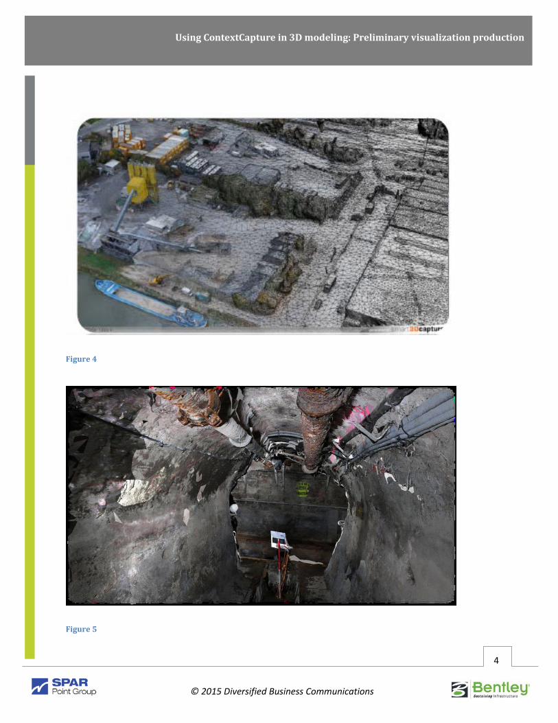
Figures 4 through 6 are representations of a Paris sewer created using aerial photography. Using
reality modeling on this project not only enabled project managers to examine at the condition of the
sewer, but also to collect additional data for the utilities in the sewers.
Using ContextCapture in 3D modeling: Preliminary visualization production
© 2015 Diversified Business Communications
4
Figure 4
Figure 5

Using ContextCapture in 3D modeling: Preliminary visualization production
© 2015 Diversified Business Communications
5
Figure 6
URBAN PLANNING: ALIGNING CONCEPTUAL DESIGN WITH REALITY The use of 3D imaging for urban planning provides robust and effective results for visualization and
organization. In Stockholm, 3D imaging was used for a conceptual planning project. Throughout the
process, the city made the plans available for residents of Stockholm to review.
Figure 7
Using ContextCapture in 3D modeling: Preliminary visualization production
© 2015 Diversified Business Communications
6
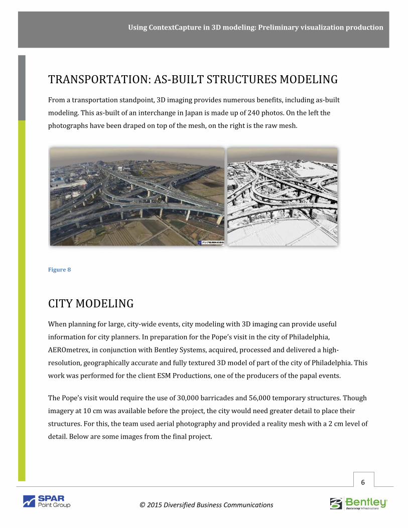
TRANSPORTATION: AS-BUILT STRUCTURES MODELING From a transportation standpoint, 3D imaging provides numerous benefits, including as-built
modeling. This as-built of an interchange in Japan is made up of 240 photos. On the left the
photographs have been draped on top of the mesh, on the right is the raw mesh.
Figure 8
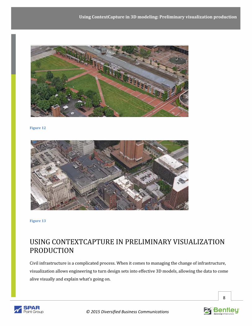
CITY MODELING When planning for large, city-wide events, city modeling with 3D imaging can provide useful
information for city planners. In preparation for the Pope’s visit in the city of Philadelphia,
AEROmetrex, in conjunction with Bentley Systems, acquired, processed and delivered a high-
resolution, geographically accurate and fully textured 3D model of part of the city of Philadelphia. This
work was performed for the client ESM Productions, one of the producers of the papal events.
The Pope’s visit would require the use of 30,000 barricades and 56,000 temporary structures. Though
imagery at 10 cm was available before the project, the city would need greater detail to place their
structures. For this, the team used aerial photography and provided a reality mesh with a 2 cm level of
detail. Below are some images from the final project.

Using ContextCapture in 3D modeling: Preliminary visualization production
© 2015 Diversified Business Communications
7
Figure 9
Figure 10
Figure 11
Using ContextCapture in 3D modeling: Preliminary visualization production
© 2015 Diversified Business Communications
8
Figure 12
Figure 13
USING CONTEXTCAPTURE IN PRELIMINARY VISUALIZATION PRODUCTION Civil infrastructure is a complicated process. When it comes to managing the change of infrastructure,
visualization allows engineering to turn design sets into effective 3D models, allowing the data to come
alive visually and explain what’s going on.

Using ContextCapture in 3D modeling: Preliminary visualization production
© 2015 Diversified Business Communications
9
When working with infrastructure, it is important to consider the value of existing conditions and
explain what’s going to change. For instance, Is it a new road? Is it a new interchange? Is it a
roundabout intersection versus a signalized intersection? Is it a new bridge? Or does it have to do with
new power lines and new sewer lines?
All of these questions lead to another major question: How is the existing condition established for the
project?
It is critical to build before and after visualizations to show both the existing conditions and proposed
conditions. ContextCapture allows you to see the existing condition three-dimensionally, as well as
interact and move around in it. You can modify the ground that the condition is on and show the new,
proposed design. Doing this in an interactively, immersive environment opens up enhanced
visualization and planning possibilities, making ContextCapture an extremely effective tool.
The street in Figure 14 presented some unique problems for transportation. The high-speed curve on
the right side of the image was adjacent to a local street. The intersection where these two roads met
proved dangerous for both pedestrians and motorists, leading to numerous accidents.
To solve this problem, the Visual Engineering Resource Group (VERG) helped the city visualize what a
new roundabout design would look like. Designers came up with different types of intersection
controls.
Coincidentally, VERG happened to be in this same location a few years prior to this project. A series of
lower-resolution, aerial photos were taken from the location with an older camera. Even though the
quality of the photos was not great, detailed mesh was created. This was then used to reflect existing
conditions.

Using ContextCapture in 3D modeling: Preliminary visualization production
© 2015 Diversified Business Communications
10
Figure 14
Figure 15 is the MicroStation model. Both MicroStation and ContextCapture are interoperable,
allowing for enhanced modeling capabilities.
Figure 15
In this case, the aerial photo shoot was submitted to ContextCapture and a mesh model was built. The
mesh model of the existing condition was exported as an OBJ 3D file and brought into MicroStation.
There was no survey control in the area, so it was scaled by hand.

Using ContextCapture in 3D modeling: Preliminary visualization production
© 2015 Diversified Business Communications
11
Figure 16
Figure 17
A major benefit in MicroStation is having the ability to take the mesh, clip a piece of it out, and take
design and attach materials to it while making everything scalable.
Using ContextCapture in 3D modeling: Preliminary visualization production
© 2015 Diversified Business Communications
12
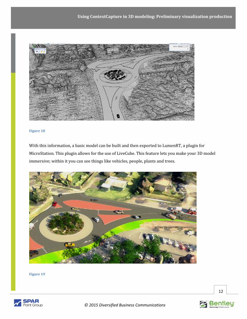
Figure 18
With this information, a basic model can be built and then exported to LumenRT, a plugin for
MicroStation. This plugin allows for the use of LiveCube. This feature lets you make your 3D model
immersive; within it you can see things like vehicles, people, plants and trees.
Figure 19

Using ContextCapture in 3D modeling: Preliminary visualization production
© 2015 Diversified Business Communications
13
Figure 20
This rich environment shows details that can impact real-world scenarios, like right-of-way issues that
might be otherwise hard to visualize. Within a few hours, you can build immersive models within the
LumenRT environment. You can even consider creating a video of the results. This is a great
visualization tool that represents your engineering design extremely well, showing a variety of angles
for the scene.
PROJECT DOCUMENTATION A critical part of any major project comes from the proper documentation.
Figure 21 is an aerial mesh of the 705/I5 interchange.

Using ContextCapture in 3D modeling: Preliminary visualization production
© 2015 Diversified Business Communications
14
Figure 21
As projects are being built, VERG relies on documentation to evaluate specific aspects of the project.
This is done not only for legal reasons, but to have a scope of the project status. Typically, this is done
from the air where still images or video are captured. These images can be effective for civil or
stakeholder gatherings or city, county governments meetings.
Figure 22
Using ContextCapture in 3D modeling: Preliminary visualization production
© 2015 Diversified Business Communications
15
Recently, VERG took ContextCapture and built a model of Interstate 5 going through Tacoma,
Washington. Construction for the project was under way, and the project engineers used the model to
discuss certain issues with right-of-way or environmental concerns. Within hours, the VERG team was
able to show an immersive 3D model that allowed members in the meeting to discuss issues in an
interactive, collaborative way.
USING CONTEXTCAPTURE IN PRELIMINARY VISUALIZATION PRODUCTION: RECOMMENDATIONS FOR PHOTO-SHOOTS With ContextCapture, the camera is the data collector. So when gathering imagery for ContextCapture
models, it’s important to remember that lighting is key. With the right lighting, you will get the right
data. Things should be well-lit, providing rich detail to feed into your model.
Some other recommendation for your photo shoot include the following:
• Learn about photography. Any type of image can be used, but higher resolution imagery will give best results.
• If using a pro or semi-pro camera and lens, set image type to RAW format.
• Keep focal length the same throughout the photo-shoot. This will make it easier for ContextCapture to integrate the imagery into its algorithms.
• Practice shooting different types of targets. The more imagery, the better. Maintain 60 percent or more over-lap per image. Shoot in a panning motion over shot location.
• Before loading your image sequence into ContextCapture, review the imagery for detail. If there are dark areas, lighten all the images so all the detail in the image can be seen (this is the reason for shooting RAW images).
TWO TYPES OF SHOOTING Capturing data from the air provides rich data for scenes like interstates or other large-scale projects.
But capturing photos from a terrestrial or ground shoot allows for the documentation of finer detail. It
is a more common utilization of ContextCapture technology since it can be done by almost anyone.

Using ContextCapture in 3D modeling: Preliminary visualization production
© 2015 Diversified Business Communications
16
Establishing targets is an important part of the shooting process. Some targets are orbited in shooting,
while others are shot across. Practice shooting these two types of targets.
1. ORBIT SHOOTING
Figures 23 and 24 are a war memorial in Washington State. Here, a focal distance was established.
Then, photos were shot a in complete circle. After this first pass, a tighter circle of shots were taken
around the structure.
Figure 23

Using ContextCapture in 3D modeling: Preliminary visualization production
© 2015 Diversified Business Communications
17
Figure 24
With this capture method, fine details can be seen, such as the texture of the granite fascia. This type of
shooting is ideal for building a model of one thing, like a building or a bus stop.
The basic steps of this collection process are:
• Fix the focal length/image frame to cover the area you want.
• Walk (or fly) around your target, taking many pictures with 60 percent or more overlap between images.
• Transition into tighter or farther away orbits if desired, still shooting images.
• Review imagery and submit to ContextCapture.

Using ContextCapture in 3D modeling: Preliminary visualization production
© 2015 Diversified Business Communications
18
2. SHOOTING ACROSS
The other side of this collection process involves shooting across a scene. This case is from a street
scene in the city of Olympia. Unlike orbit shooting, shooting across doesn’t focus on one thing or object,
but multiple things and object that make up a scene. This type of data collection is valuable to urban
planners, landscape architects, police or security.
With this approach, shooting can be done in multiple locations. In this case, the geometry of the
shooting is an oval. At each separate spot, multiple shots were taken in a sweeping arc mode.
Figure 25

Using ContextCapture in 3D modeling: Preliminary visualization production
© 2015 Diversified Business Communications
19
Figure 26
Figure 27

Using ContextCapture in 3D modeling: Preliminary visualization production
© 2015 Diversified Business Communications
20
Figure 28
The basic steps of this collection process are:
• Fix the focal length/image frame to cover the area you want.
• Walk around your target, shooting across the street, room, etc. to the other side of the target, taking many pictures with 60 percent or more overlap between images. This technique is for enclosed areas.
• Take five to six images per spot in panoramic way. Move a few feet in one direction and repeat. Continue all around, shooting across the target. Complete the circle and continue tighter or farther away.
• Review imagery and submit to ContextCapture.
Using ContextCapture in 3D modeling: Preliminary visualization production
© 2015 Diversified Business Communications
21
CONCLUSION One of the greatest things about data collection and reality modeling today is the ease of use and
enhanced collaboration capabilities that come with it. The benefits of ContextCapture are numerous.
From a dense point cloud that has been processed/analyzed with dedicated software, to a textured 3D
triangular mesh, ContextCapture offers numerous was to generate and analyze data for modeling
purposes. And because it is part of the Bentley Systems portfolio of products, ContextCapture can
produce 3MX formats that can be opened in MicroStation CONNECT, and used as a 3D context for
analysis or design processes.
This immersive program is ideal for urban planning, and documenting existing conditions to identify
infrastructure change. This allows for more a visual work environments, and provides more value to
your client. That’s because capturing existing conditions is worth its weight in gold when you are
trying to accomplish an agenda. And since the program is easy to learn, it can be used throughout your
team, allowing you to cover more ground, knowing you have collected valuable data.
CONTRIBUTORS Mo Harmon, Solutions Executive, Roads and Bridges, Bentley
Mr. Harmon earned an engineering degree from Louisiana State University. He has worked in the
consulting industry for the past 26 years, before joining Bentley Systems as the solution executive for
roads and bridges. Mr. Harmon spent his first eight years in transportation design, before moving into
a firm-wide role as an InRoads trainer. Over time, his role expanded to managing both training,
support and R&D activities associated with core design and production technologies for HNTB. A key
responsibility over the past six years has been associated with the deployment of technologies and
procedures that reduce risk, reduce schedule and deliver the right data at the right time on design-
build projects.

Using ContextCapture in 3D modeling: Preliminary visualization production
© 2015 Diversified Business Communications
22
Kurt Stiles, VERG Manager, WSDOT
Mr. Stiles left WSDOT Structural Engineering in 1998 to become a pioneering member in a new group
centered on visually communicating engineering design for his state DOT. In 2009, he took over the
group and reorganized it into the Visual Engineering Resource Group, excelling at infrastructure-based
visual communications.
Ron Jones, VERG 3D Modeler-Animator, WSDOT
Mr. Jones left engineering planned management in 1998 and joined group centered on visually
communicating engineering design for his state DOT. Today he is the chief 3D modeler animator at the
Visual Engineering Resource Group and has completed many award-winning visualizations and
animations.
* Note: This whitepaper is the product of the transcript of a live webinar on www.SPARPointGroup.com. While the
speakers are cited here as contributors, this whitepaper was not written by the contributors or speakers who
appeared in the presentation, nor is it endorsed by the contributors or speakers, or any company, organization or
entity they represent. For more information on how this whitepaper was produced, send inquiries via email to