using gis technology with linux -...
TRANSCRIPT
ESRI 380 New York St., Redlands, CA 92373-8100, USA • TEL 909-793-2853 • FAX 909-793-5953 • E-MAIL [email protected] • WEB www.esri.com
Using Geographic Information System Technology With Linux
An ESRI
® White Paper • June 2002

Copyright © 2002 ESRI All rights reserved. Printed in the United States of America. The information contained in this document is the exclusive property of ESRI. This work is protected under United States copyright law and other international copyright treaties and conventions. No part of this work may be reproduced or transmitted in any form or by any means, electronic or mechanical, including photocopying and recording, or by any information storage or retrieval system, except as expressly permitted in writing by ESRI. All requests should be sent to Attention: Contracts Manager, ESRI, 380 New York Street, Redlands, CA 92373-8100, USA. The information contained in this document is subject to change without notice.
U.S. GOVERNMENT RESTRICTED/LIMITED RIGHTS Any software, documentation, and/or data delivered hereunder is subject to the terms of the License Agreement. In no event shall the U.S. Government acquire greater than RESTRICTED/LIMITED RIGHTS. At a minimum, use, duplication, or disclosure by the U.S. Government is subject to restrictions as set forth in FAR §52.227-14 Alternates I, II, and III (JUN 1987); FAR §52.227-19 (JUN 1987) and/or FAR §12.211/12.212 (Commercial Technical Data/Computer Software); and DFARS §252.227-7015 (NOV 1995) (Technical Data) and/or DFARS §227.7202 (Computer Software), as applicable. Contractor/Manufacturer is ESRI, 380 New York Street, Redlands, CA 92373-8100, USA. @esri.com, 3D Analyst, ADF, AML, ARC/INFO, ArcAtlas, ArcCAD, ArcCatalog, ArcCOGO, ArcData, ArcDoc, ArcEdit, ArcEditor, ArcEurope, ArcExplorer, ArcExpress, ArcFM, ArcGIS, ArcGrid, ArcIMS, ArcInfo Librarian, ArcInfo, ArcInfo—Professional GIS, ArcInfo—The World's GIS, ArcLogistics, ArcMap, ArcNetwork, ArcNews, ArcObjects, ArcOpen, ArcPad, ArcPlot, ArcPress, ArcQuest, ArcReader, ArcScan, ArcScene, ArcSchool, ArcSDE, ArcSdl, ArcStorm, ArcSurvey, ArcTIN, ArcToolbox, ArcTools, ArcUSA, ArcUser, ArcView, ArcVoyager, ArcWatch, ArcWeb, ArcWorld, Atlas GIS, AtlasWare, Avenue, BusinessMAP, Database Integrator, DBI Kit, ESRI, ESRI—Team GIS, ESRI—The GIS People, FormEdit, Geographic Design System, Geography Matters, Geography Network, GIS by ESRI, GIS Day, GIS for Everyone, GISData Server, InsiteMAP, MapBeans, MapCafé, MapObjects, ModelBuilder, MOLE, NetEngine, PC ARC/INFO, PC ARCPLOT, PC ARCSHELL, PC DATA CONVERSION, PC STARTER KIT, PC TABLES, PC ARCEDIT, PC NETWORK, PC OVERLAY, Rent-a-Tech, RouteMAP, SDE, SML, Spatial Database Engine, StreetEditor, StreetMap, TABLES, the ARC/INFO logo, the ArcAtlas logo, the ArcCAD logo, the ArcCAD WorkBench logo, the ArcCOGO logo, the ArcData logo, the ArcData Online logo, the ArcEdit logo, the ArcEurope logo, the ArcExplorer logo, the ArcExpress logo, the ArcFM logo, the ArcFM Viewer logo, the ArcGIS logo, the ArcGrid logo, the ArcIMS logo, the ArcInfo logo, the ArcLogistics Route logo, the ArcNetwork logo, the ArcPad logo, the ArcPlot logo, the ArcPress for ArcView logo, the ArcPress logo, the ArcScan logo, the ArcScene logo, the ArcSDE CAD Client logo, the ArcSDE logo, the ArcStorm logo, the ArcTIN logo, the ArcTools logo, the ArcUSA logo, the ArcView 3D Analyst logo, the ArcView Business Analyst logo, the ArcView Data Publisher logo, the ArcView GIS logo, the ArcView Image Analysis logo, the ArcView Internet Map Server logo, the ArcView logo, the ArcView Network Analyst logo, the ArcView Spatial Analyst logo, the ArcView StreetMap 2000 logo, the ArcView StreetMap logo, the ArcView Tracking Analyst logo, the ArcWorld logo, the Atlas GIS logo, the Avenue logo, the BusinessMAP logo, the Data Automation Kit logo, the Digital Chart of the World logo, the ESRI Data logo, the ESRI globe logo, the ESRI Press logo, the Geography Network logo, the MapCafé logo, the MapObjects Internet Map Server logo, the MapObjects logo, the MOLE logo, the NetEngine logo, the PC ARC/INFO logo, the Production Line Tool Set logo, the RouteMAP IMS logo, the RouteMAP logo, the SDE logo, The World's Leading Desktop GIS, Water Writes, www.esri.com, www.geographynetwork.com, www.gisday.com, and Your Personal Geographic Information System are trademarks, registered trademarks, or service marks of ESRI in the United States, the European Community, or certain other jurisdictions. Other companies and products mentioned herein are trademarks or registered trademarks of their respective trademark owners.
J-8943
ESRI White Paper i
Using Geographic Information System Technology With Linux
An ESRI White Paper Contents Page Introduction .......................................................................................... 1 ESRI UNIX Support............................................................................. 1 ESRI Linux Support ............................................................................. 2
ArcSDE 8.2: The Geodatabase...................................................... 2 ArcSDE 8 Capabilities ............................................................. 2 System Requirements for ArcSDE 8.2 Under Linux ............... 3
ArcIMS: Web Mapping and More ................................................ 3 ArcIMS Capabilities................................................................. 3 Metadata Capability ................................................................. 4 Java Capability ......................................................................... 4 ArcMap Compatibility ............................................................. 4 ArcIMS Route Server............................................................... 4 System Requirements for ArcIMS 4 Under Linux................... 5
MapObjects—Java Standard Edition: Clientside Tools................ 5 Key Features of MapObjects—Java Standard Edition............. 6 System Requirements for MapObjects—Java Standard Edition..................................................................... 6
ArcExplorer: Free Geodata Viewer............................................... 6 ArcObjects: Developer Solutions.................................................. 7
MainWin Technology............................................................... 8 ArcObjects for UNIX: Summary............................................. 9
J-8943
ESRI White Paper
Using Geographic Information System Technology With Linux
Introduction Building on a long history of cross-platform support including UNIX releases of industry-leading geographic information system (GIS) technology, ESRI is currently releasing components of its ArcGIS™
product line for Linux users. This white paper explains what components ESRI is making available in the Linux environment, provides a brief description of these components, and provides additional information about the technology used to accomplish the port to Linux.
ESRI UNIX Support UNIX is not a new platform for ESRI; in fact, it has been a primary platform for ESRI software users for many years. ESRI released its first UNIX product in the early 1980s, when ArcInfo™ was originally ported from the Prime minicomputer environment to UNIX. Over the years, in response to both user needs and changes in the marketplace, ESRI has supported a number of different "flavors" of UNIX including ! Red Hat Linux—Intel ! Sun Solaris ! HP-UX ! IBM AIX ! Compaq TRU64 ! Silicon Graphics IRIX Our goal is to deliver ESRI® products on multiple platforms. ESRI's software products will be supported on the set of computing platforms that are most appropriate for each (i.e., high-end desktops, servers, and devices). ! ArcGIS Desktop applications: primarily Windows, with some UNIX support
! ArcGIS servers: Windows and UNIX support
! ArcGIS clients: HTML (browsers), Java applications, Pocket PC (Windows CE),
and Windows platforms
Using Geographic Information System Technology With Linux
J-8943
June 2002 2
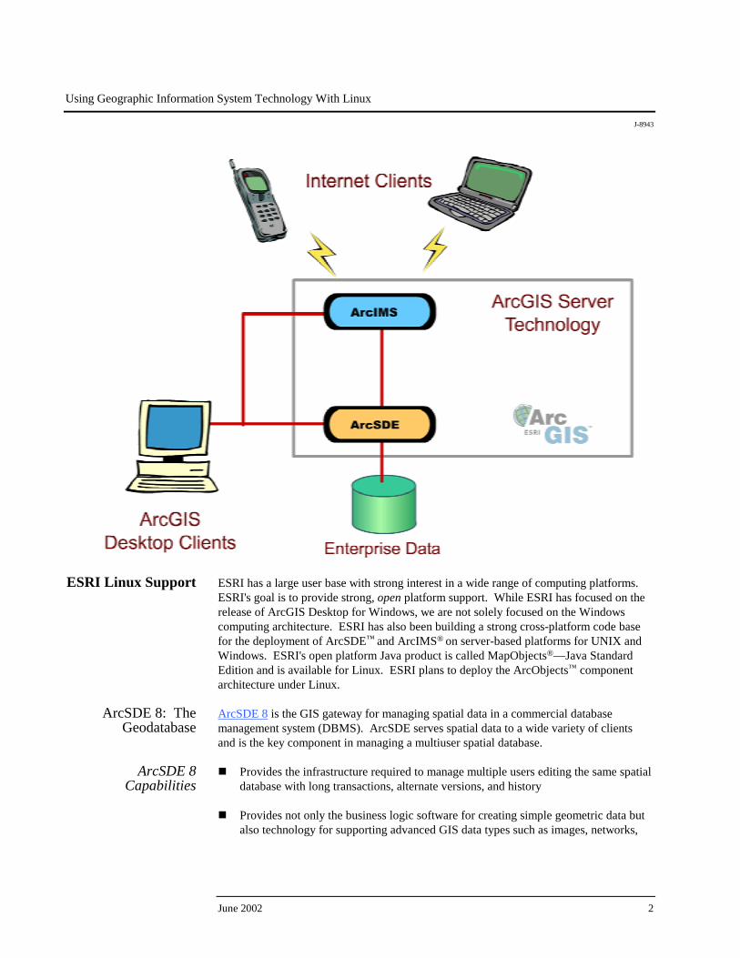
ESRI Linux Support ESRI has a large user base with strong interest in a wide range of computing platforms. ESRI's goal is to provide strong, open platform support. While ESRI has focused on the release of ArcGIS Desktop for Windows, we are not solely focused on the Windows computing architecture. ESRI has also been building a strong cross-platform code base for the deployment of ArcSDE™ and ArcIMS® on server-based platforms for UNIX and Windows. ESRI's open platform Java product is called MapObjects®—Java Standard Edition and is available for Linux. ESRI plans to deploy the ArcObjects™ component architecture under Linux.
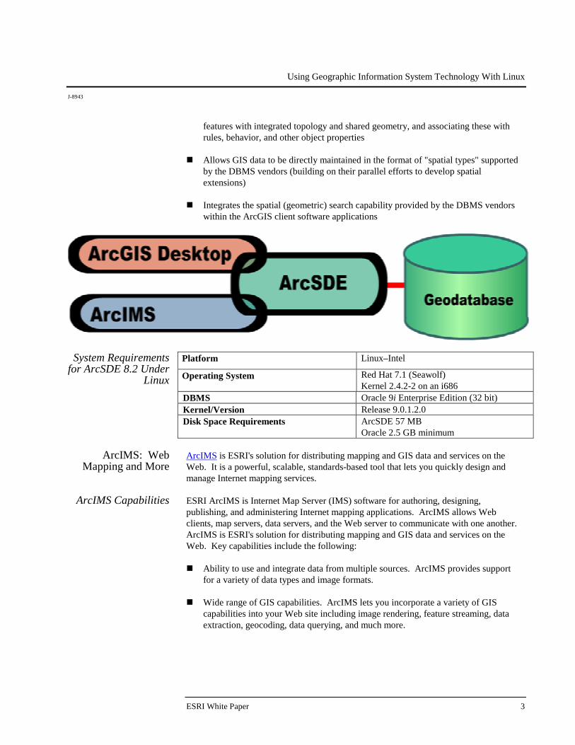
ArcSDE 8: The Geodatabase
ArcSDE 8 is the GIS gateway for managing spatial data in a commercial database management system (DBMS). ArcSDE serves spatial data to a wide variety of clients and is the key component in managing a multiuser spatial database.
ArcSDE 8 Capabilities
! Provides the infrastructure required to manage multiple users editing the same spatial database with long transactions, alternate versions, and history
! Provides not only the business logic software for creating simple geometric data but
also technology for supporting advanced GIS data types such as images, networks,
Using Geographic Information System Technology With Linux
J-8943
ESRI White Paper 3
features with integrated topology and shared geometry, and associating these with rules, behavior, and other object properties
! Allows GIS data to be directly maintained in the format of "spatial types" supported
by the DBMS vendors (building on their parallel efforts to develop spatial extensions)
! Integrates the spatial (geometric) search capability provided by the DBMS vendors
within the ArcGIS client software applications
Platform Linux–Intel System Requirements for ArcSDE 8.2 Under
Linux Operating System Red Hat 7.1 (Seawolf) Kernel 2.4.2-2 on an i686
DBMS Oracle 9i Enterprise Edition (32 bit) Kernel/Version Release 9.0.1.2.0 Disk Space Requirements ArcSDE 57 MB
Oracle 2.5 GB minimum
ArcIMS: Web Mapping and More
ArcIMS is ESRI's solution for distributing mapping and GIS data and services on the Web. It is a powerful, scalable, standards-based tool that lets you quickly design and manage Internet mapping services.
ArcIMS Capabilities ESRI ArcIMS is Internet Map Server (IMS) software for authoring, designing, publishing, and administering Internet mapping applications. ArcIMS allows Web clients, map servers, data servers, and the Web server to communicate with one another. ArcIMS is ESRI's solution for distributing mapping and GIS data and services on the Web. Key capabilities include the following: ! Ability to use and integrate data from multiple sources. ArcIMS provides support
for a variety of data types and image formats. ! Wide range of GIS capabilities. ArcIMS lets you incorporate a variety of GIS
capabilities into your Web site including image rendering, feature streaming, data extraction, geocoding, data querying, and much more.
Using Geographic Information System Technology With Linux
J-8943
June 2002 4
! Highly scalable architecture. Specifically designed to grow with an organization, ArcIMS is a completely scalable solution for publishing GIS data, maps, and applications.
! Standards-based communication. ArcIMS clients and servers communicate using
ArcXML, which is a GIS extension to standard Extensible Markup Language (XML).
! Support for a wide range of clients. ArcIMS allows you to select the client that best
suits your needs from wireless appliances, such as cellular phones and personal digital assistants, to lightweight browser-based clients or a full-featured GIS desktop client.
Metadata Capability One of the most significant features included in ArcIMS 4 is the ability to create a central
repository for publishing and browsing metadata over the Internet using ArcIMS in conjunction with ESRI's ArcSDE and ArcGIS Desktop. Metadata can easily be authored using the ArcGIS ArcCatalog™ application, published to a metadata server, and then quickly searched by others. Along with ArcIMS software's metadata services, users also receive the Metadata Explorer, which is a JavaServer Pages (JSP) application that can be used to build a customized, browser-based means of searching for data.
Java Capability As part of ESRI's strategy of offering more GIS capabilities for the Java developer, ArcIMS now comes with a Java Connector, which allows developers to program Java clients and applications that use a set of JavaBeans. A new object model, JSP tag libraries based on the new object model, and a full range of samples are included. ArcIMS 4 also includes new JSP-based administration tools along with the standard HTML-based tools for greater flexibility and cross-platform support.
ArcMap Compatibility
The ArcIMS ArcMap™ Server ties ESRI's ArcGIS family of products and ArcIMS more closely together. The ArcIMS ArcMap Server allows files created in the ArcGIS ArcMap application or ArcGIS Publisher to be shared over the Internet using ArcIMS. With the ArcIMS ArcMap Server, users can leverage all the data access and cartographic capabilities of ArcMap.
ArcIMS Route Server ArcIMS 4 also supports the optional ArcIMS Route Server extension. The ArcIMS Route Server offers the ability to incorporate fast, accurate routing and point-to-point driving directions into Web sites built with ArcIMS. It is compatible with both ArcIMS 3.1 and ArcIMS 4.
Using Geographic Information System Technology With Linux
J-8943
ESRI White Paper 5
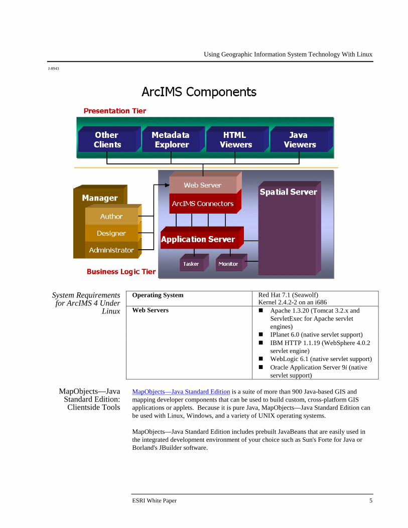
Operating System Red Hat 7.1 (Seawolf)
Kernel 2.4.2-2 on an i686 System Requirements for ArcIMS 4 Under
Linux Web Servers ! Apache 1.3.20 (Tomcat 3.2.x and ServletExec for Apache servlet engines)
! IPlanet 6.0 (native servlet support) ! IBM HTTP 1.1.19 (WebSphere 4.0.2
servlet engine) ! WebLogic 6.1 (native servlet support)
! Oracle Application Server 9i (native servlet support)
MapObjects—Java
Standard Edition: Clientside Tools
MapObjects—Java Standard Edition is a suite of more than 900 Java-based GIS and mapping developer components that can be used to build custom, cross-platform GIS applications or applets. Because it is pure Java, MapObjects—Java Standard Edition can be used with Linux, Windows, and a variety of UNIX operating systems. MapObjects—Java Standard Edition includes prebuilt JavaBeans that are easily used in the integrated development environment of your choice such as Sun's Forte for Java or Borland's JBuilder software.
Using Geographic Information System Technology With Linux
J-8943
June 2002 6
Key Features of MapObjects—Java
Standard Edition
! The ability to combine multiple data sources (local and Internet or Intranet) to create customized maps
! Connectivity with ArcIMS (ESRI's GIS for the Internet) ! A wide range of GIS capabilities and compatibility with many data sources including
industry-standard shapefiles, ArcSDE layers, and a variety of image formats such as BMP, TIFF, PNG, JPG, and GIF
! Ability to create feature layers from custom data sources For more information, download Geographic Information Systems for Java—an ESRI white paper. Operating System Red Hat 7.1 (Seawolf)
Kernel 2.4.2-2 on an i686 System Requirements
for MapObjects—Java Standard Edition
ArcExplorer: Free
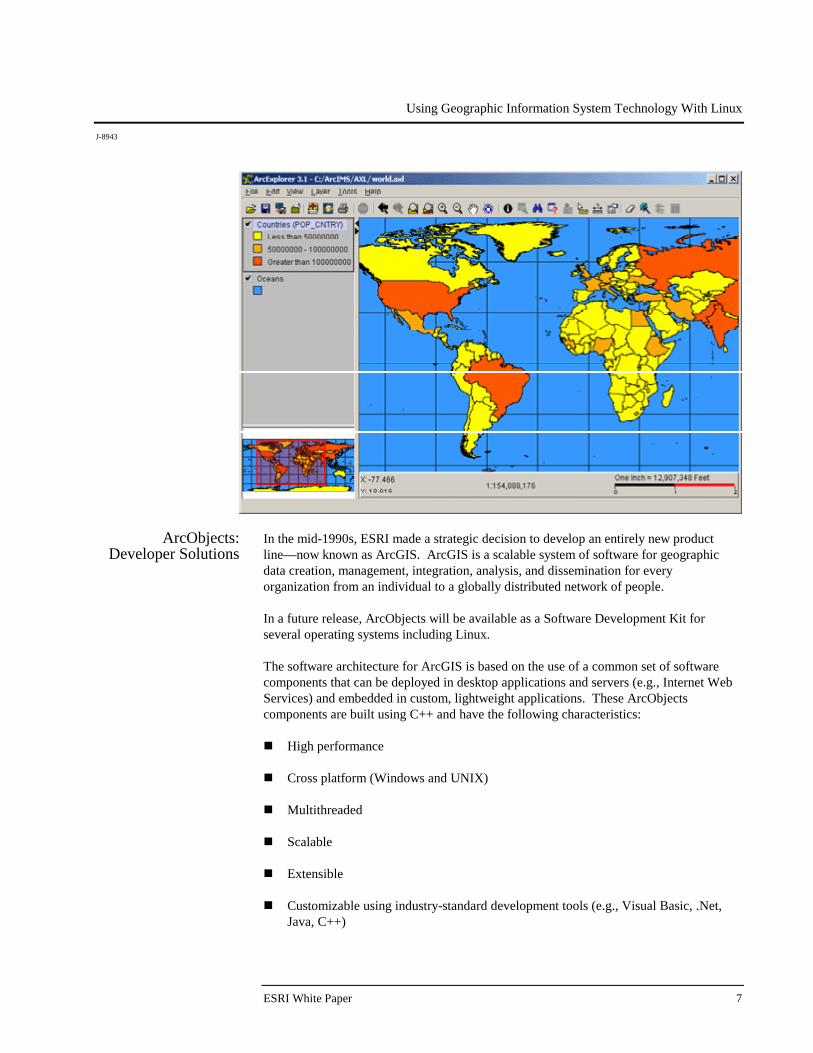
Geodata Viewer ArcExplorer™ 4—Java Edition is the newest version of ESRI's free GIS data viewer. Because it is built with Java, ArcExplorer 4 allows users to enjoy cross-platform support including compatibility with Linux, Windows, and a number of UNIX operating systems. ArcExplorer is a lightweight GIS data viewer developed by ESRI. This freely available software offers an easy way to perform basic GIS functions. ArcExplorer is used for a variety of display, query, and data retrieval applications and supports a wide variety of standard data sources. It can be used on its own with local data sets or as a client to Internet data and map servers. Among its many uses, ArcExplorer is an excellent vehicle for publishing your data. You can distribute the ArcExplorer setup and your data on CDs. You can then use the CD to install ArcExplorer on their machines and view your data easily and effectively. And best of all, ESRI does not charge any fees for you to distribute ArcExplorer with your data.
Using Geographic Information System Technology With Linux
J-8943
ESRI White Paper 7
ArcObjects: Developer Solutions
In the mid-1990s, ESRI made a strategic decision to develop an entirely new product line—now known as ArcGIS. ArcGIS is a scalable system of software for geographic data creation, management, integration, analysis, and dissemination for every organization from an individual to a globally distributed network of people. In a future release, ArcObjects will be available as a Software Development Kit for several operating systems including Linux. The software architecture for ArcGIS is based on the use of a common set of software components that can be deployed in desktop applications and servers (e.g., Internet Web Services) and embedded in custom, lightweight applications. These ArcObjects components are built using C++ and have the following characteristics: ! High performance ! Cross platform (Windows and UNIX) ! Multithreaded ! Scalable ! Extensible ! Customizable using industry-standard development tools (e.g., Visual Basic, .Net,
Java, C++)
Using Geographic Information System Technology With Linux
J-8943
June 2002 8
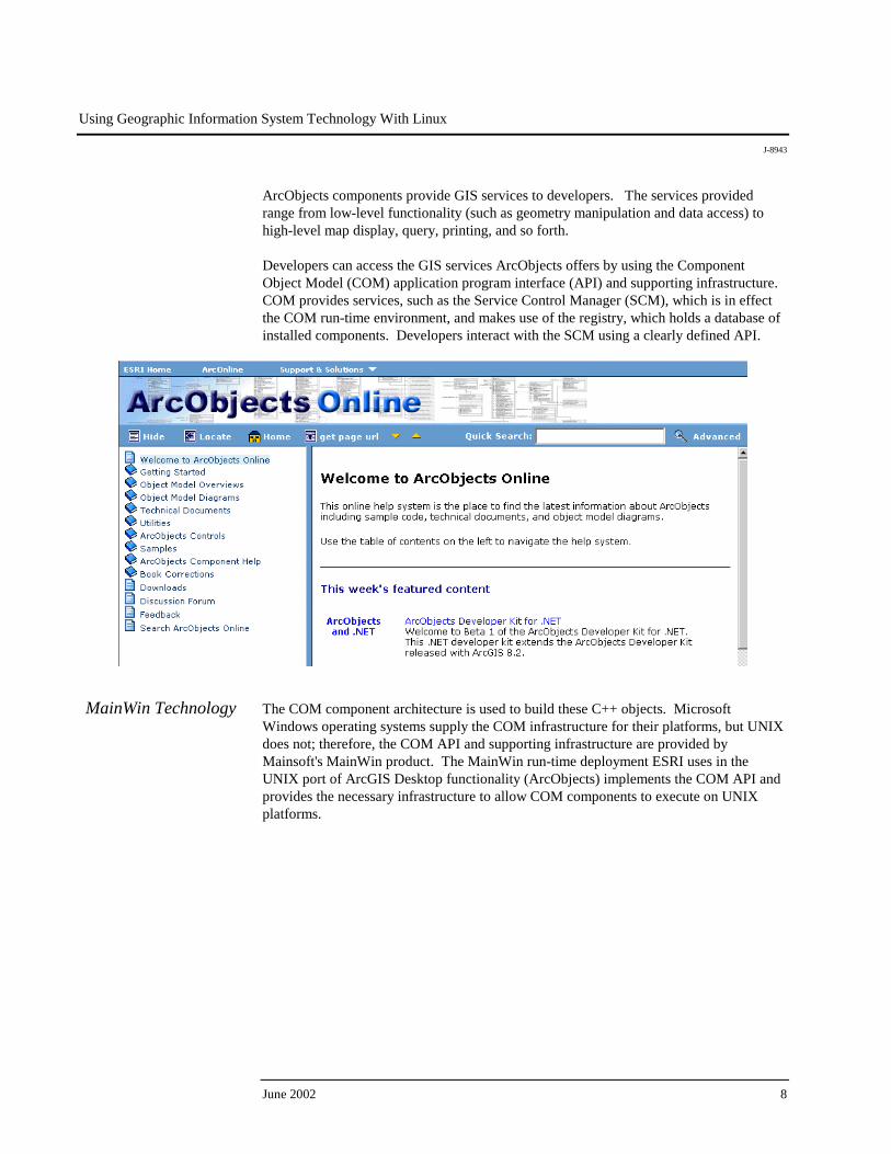
ArcObjects components provide GIS services to developers. The services provided range from low-level functionality (such as geometry manipulation and data access) to high-level map display, query, printing, and so forth. Developers can access the GIS services ArcObjects offers by using the Component Object Model (COM) application program interface (API) and supporting infrastructure. COM provides services, such as the Service Control Manager (SCM), which is in effect the COM run-time environment, and makes use of the registry, which holds a database of installed components. Developers interact with the SCM using a clearly defined API.
MainWin Technology The COM component architecture is used to build these C++ objects. Microsoft
Windows operating systems supply the COM infrastructure for their platforms, but UNIX does not; therefore, the COM API and supporting infrastructure are provided by Mainsoft's MainWin product. The MainWin run-time deployment ESRI uses in the UNIX port of ArcGIS Desktop functionality (ArcObjects) implements the COM API and provides the necessary infrastructure to allow COM components to execute on UNIX platforms.
Using Geographic Information System Technology With Linux
J-8943
ESRI White Paper 9
ArcObjects for UNIX: Summary
The UNIX version of ArcObjects affirms ESRI's long-standing commitment to the UNIX community to provide them with robust, professional GIS tools comparable to the tools ESRI provides in the Windows environment. In summary ! ESRI has many years of experience in successfully porting and supporting cross-
platform GIS tools applications.
! ESRI has a long history of supporting UNIX applications and is fully committed to supporting the UNIX version of ArcObjects.
! ESRI's UNIX version of ArcObjects is robust, offering capabilities and performance comparable to the Windows version.
! ESRI uses the MainWin software from Mainsoft because it is the best technology available for porting ArcObjects technology to work in the UNIX environment.
! MainWin development software is needed only if a developer wishes to extend the COM classes of ArcObjects or create new COM components.
! MainWin development software is not needed if a developer only wishes to create, use, and manage the COM classes of ArcObjects components.
Standard UNIX developer tools, such as Java and C++, can be used under Linux for customizing applications.