using research to teach the methods of geoscience anne e
TRANSCRIPT

UsingresearchtoteachthemethodsofgeoscienceAnneE.Egger
CentralWashingtonUniversityForsevenyears,Itaughtatahighlyselective,research‐intensiveinstitutionthatattractsveryintelligentstudents.MyjobatStanfordUniversityincludedrecruitingstudentsintofourdifferentundergraduatemajorsintheSchoolofEarthSciences,teachingintroductorygeosciencecourses,andrunningourundergraduateresearchprogram.Inallofthesevenues,studentstoldmeabouttheirperceptionsofthegeosciences,andwhatIlearnedinthatprocesshadaprofoundeffectonhowItaughtandtalkedaboutmydiscipline.ItwillnotsurpriseanyonereadingthisthatfewstudentsarrivedatStanfordintendingtomajorinthegeosciences.Myintroductorycourseswerenotpopulatedprimarilybywide‐eyedfreshmenseekingacalling,butbyseniorsinvariousengineeringmajorswhowerefulfillinganaturalsciencerequirement.Ilikedhavingtheengineersintheclass:theyweresmart,hadexcellenttechnicalwritingskills,anddidn’tputupwithanythingtheysawasbusywork.Theyalsochafedundermyinquiry‐basedteachingstyle,inwhichIusuallyletthemstrugglewithdataorrocksamplesormaps,collectingtheirowndatabeforedoinganyexplaining.Ioftenreceivedcommentsthatweresomevariationof,“Allofthisexplorationisinefficient.JusttellmewhatIneedtoknow.”Buttheirpresenceinmyclassesgavemetheopportunitytopointoutthedifferentwaysthatengineersandgeologistscalledonthesameconceptsandappliedthemindifferentways.Icalledonthemechanicalengineerstotellmehowtheyusedstressandstrain:tomanufactureamaterialthathadlowstrainunderhighstress,perhaps.Icontrastedthatwithhowgeologistsusestressandstrain:measuringstraintodeterminethepast(orpresent)stress.Theequationsandconceptswereidentical,butthemethodswithwhichtheyweredeployedweredisciplinespecific.WhenImadetheseconnections,Isawmanyengineersstarttonodtheirheadsinclass.Ah,Icouldseethemthinking,thatmakessense.Engagingtheengineersinclasswassatisfying,butitwasnotmyonlygoal.IsoughttoengagestudentsfromavarietyofbackgroundsinresearchintheEarthsciences,whetherornottheychosetomajorinit.Thismeantcastingawidenet,explainingwhatconstitutestheEarthsciences,andhelpingstudentsfrommajorslikecomputerscience,electricalengineering,physics,andhistory,tonameafew,succeedinrealresearchintheEarthsciences.Castingthenetclearlyneededtogobeyondmyintroductorycourses.Thoughtherewere,indeed,afewintrepidfreshmenandundecidedstudentswhowadedintothisclass,mosthadalreadychosenadisciplineandwerepursuingit.TheythoughttheEarthscienceswereasortofquaintbackwaterwherepeopleactuallyhadtotouchrealstuff(likerocks)ratherthancomputerkeyboards.Asaresult,Icreateda1‐unitcourseaimed

atfreshmenwhojustwantedtolearnmoreaboutwhatwasgoingonintheEarthsciencesatStanford.Adifferentfacultymembervisitedeachweektotalkabouttheirresearch.IworkedwiththemtoensurethattheyweretalkingabouttheirresearchatthelevelofastudentwhomightbesmartbuthavenobackgroundinEarthscience.Ialsoaskedthemtotalkexplicitlyaboutthemethodsthattheyusetodotheirwork.Acrosstheboard,withoutmyprompting,theyalltalkedabouthowtheyusedseveralmethodstodevelopmultiplelinesofevidencetosupporttheirideas.AnumberofstudentswhotookthisclasschosenottomajorintheEarthsciencesbutdidgetinvolvedinresearchwithourfaculty,convincedthattherewereexcitinganinnovativefrontiershereaselsewhere.TheyeithersawhowtheirskillscouldcontributetoEarthsciencesresearch(oftenthecasewithcomputersciencemajors)ortheysimplywantedtopursueatopictheywereinterestedin.BringingthesestudentsfromotherdisciplinesintotheEarthsciencestoconductresearchwasnosmalltask,however.Bycastingthewidenet,wewerecatchingstudentswhohadnevertakenanintroductorygeologycourseorbeenonafieldtriptolookatrocks.Toaccommodatethisvariabilityinpreparation,IdevelopedacoursewithafacultymemberinGeophysicstointroducethesestudentstoresearch.Whilemuchofwhatwedidwasbroadlyapplicabletotheresearchprocessasawhole(readingscientificjournalarticles,workingwithyouradvisor),certaintopicsfocusedonthemethodsofEarthsciencespecifically.Howdoyoudevelopanhypothesisforafield‐based,non‐experimentalstudy?Whatisthegoalofdevelopingamodelfor,say,avolcaniceruption?Whydoyourpeersinotherdisciplinesstartwritinguptheirresultsattheendofthesummerwhenyouarejustbeginningtoprocessyoursamples?Theseexperiencesworkingwithundergraduatestudentsinresearchfedbackintoallofmyteaching,atalllevels.MyclassesevolvedtoincludewhatIconsidermuchmorefrequentandexplicitmentionsofwhatitmeanstobeageoscientist,themethodsthatgeoscientistsusetoaddressquestions,andthenatureofongoingresearchinthegeosciences.Inmyintroductorycourse,IendedeverytopicbytalkingaboutwhointheschoolatStanfordwasdoingresearchinthatareaandthekindsofquestionstheywerestillasking.Thisinvariablyprovokeddiscussionandoccasionallyinspiredastudenttopursuemoreclassesorresearch.Inmymoreadvancedcourses,wespenttimediscussingacceptablelevelsofuncertaintygoingbackfurtherintogeologictime.Ingeneral,inmygeosciencesclasses,Ithinkofmyselfasnarratingwhatwearedoingateverystepoftheway.Thatnarrationmightincludecontrastingtheapproachageologistwouldtakewiththatofanengineerorgeophysicist.Itdefinitelyincludesthemethodsused,andwhatotherlinesofevidencesupportagivenconclusion.Itincludesactualcontributionsbyactualpeople,andthequestionsthatthosepeoplestillhaveaboutaparticularphenomenon.Andimportantlyforme,itincludesthethingsastudentwouldhavetodotogetinvolvedinaddressingthosequestions:whototalkto,classestotake,skillstodevelop.

However,Iamalsonowinaverydifferentsetting,teachingclassesfilledwithelementaryeducationmajors.Asidefromthefactthatmanyofthesestudentsarescience‐phobic,theemphasisintheelementarycurriculum(andthustheteacherpreparationcurriculum)isonexperimentation.Despitethedifferencesbetweenthesestudentsand(forexample)engineeringmajors,Iamabletoemploysimilartacticstointroducethemtothemethodsofgeoscience.Myemphasisshiftstohighlightalternativestoexperimentationfortestingideasandforhowitispossibletoincorporatethosealternativesintoanelementaryclassroom.Theassociationof“experiment”and“science”isverydeeplyengrained,however,anditcanbechallengingtoovercomenotonlywiththesestudentsbutwithfacultyinmoreclassicallyexperimentaldisciplinesthatteachthesecourses.Isupposethatmyultimategoalinnarratingtheprocessofgeosciencesothoroughlyistofindsomethinginthereforeveryone.Thefutureengineerwillbeinterestedintheboreholestrainmeasurementsreflectingplateboundaryprocesses;thecomputerscientistwillwanttounderstandhowthemodelofshakingfromamagnitude9earthquakeinCascadiawasbuilt.Afutureteacherwantstouseobservationsoftheworldintheelementaryclassroomasascientifictool.Byexplicitlyincludingthemethodsofgeoscienceinmyteaching,Ihopetoencourageandfosterallofthoseinterests.

TeachingGeoscienceMethodsintheField
DavidMogk,Dept.ofEarthSciences,MontanaStateUniversity
Learning in the field has traditionally been one of the fundamental components of the geoscience curriculum. There are many attributes of learning in the field environment that address teaching GeoMethods: definition of learning goals related to mastery of geoscience concepts and content; the development of professional skill sets that are used to describe, characterize, measure, and interpret data acquired directly from natural environments; leveraging the affective, cognitive and metacognitive gains afforded to students through learning in the field; and engagement by students in the community of practice that has been developed and accepted by geoscientists as a result of field studies. An awareness of these attributes will contribute to the design, development and implementation of effective instruction in the field. The following is a summary of a more comprehensive review of learning in the field by Mogk and Goodwin (2012) as part of the Synthesis of Research on Learning in the Geosciences project. Additional insights into teaching and learning in the field can be found in Whitmeyer et al., (2009). Teaching GeoMethods in a field setting must be done in consideration of many factors. First, learning in the field is meant to encompass a range of activities that are physically conducted in the natural environment: making primary observations of Nature; taking samples; making measurements; directly using the human senses; and indirectly using instrumental sensors to interact with Earth objects and processes. The Earth system is inherently complex, dynamic, heterogeneous, and often chaotic, and presents many challenges to geoscience education. Frodeman (1995) has emphasized the historical and interpretive aspects of geoscience (as opposed to bench top, experimental science mostly done in highly constrained, closed systems). The geologic record is often incomplete or ambiguous, and consequently, the nature of geoscience expertise requires the development of cognitive strategies that allow geoscientists to work effectively in a world in which the available evidence is complex, uncertain, and often missing. It is also important to consider the scope of field instruction that may range from a two-hour laboratory exercise in a location proximal to the classroom to sustained residential field camps with a duration of weeks to months. Field activities may be immersive or reconnaissance in nature, require geologic mapping on many scales, may focus on sampling activities, perhaps focus on measurements of geologic phenomena (stratigraphic sections, stream gauging), and increasingly use instrumentation (field geophysical surveys) or computer-based technologies (“GeoPads”) in the conduct of field work. Considerations for teaching GeoMethods related to field instruction include: • Students experience direct contact with the raw materials of Nature in their full
complexity, while in the lab, samples are presented without the full context of their natural setting; and, the rational for collecting particular samples may be lost;
• In the field, the scale of observation is large with respect to the observer and thus perception is from an internal spatial viewpoint, whereas in the lab the student

observer is large compared with lab samples; • Physical movement through the field setting engages all of the senses which are
strongly coupled with cognition and access by long term memory for future retrieval and use;
• Field work provides unique perspectives of the world, particularly related to spatial and temporal relations, that cannot be reproduced in laboratory or virtual environments;
• The field setting is a particularly rich environment where students have to make their own informed decisions about what to observe, for what purpose, how to represent these observations and how to interpret and ascribe meaning to their work.
• A trained eye must be developed to know what to look for in complex natural landscapes, as much of the sensory input may be irrelevant to the task at hand; in the lab setting, the objects of study have been selected by someone else and are specifically relevant to the topic of study;
• The field setting has a strong affective component that impacts learning. In some cases, there is a strong motivation to learn based on curiosity, awe and wonder; in other cases there may be significant barriers to learning that derive from fear or uncertainty. The affective domain also extends to interpersonal relations, and strong affiliative ties may develop between students, their peers, and mentors. Managed appropriately, students can gain an enhanced sense of self-confidence and self-reliance.
• The field setting also has a very strong metacognitive component. Field instruction can help students become self-aware of their approach to a given field task, to self-monitor their progress, and self-regulate their actions and make informed decisions as they confront emerging problems, unexpected findings or inconsistencies.
Cognitive, learning and social sciences provide additional insights into the value of field instruction, and why this is so important to teaching GeoMethods:
• The full range of cognitive skills (e.g. Bloom’s taxonomy) are engaged in field studies from primary observations and descriptions to higher order thinking sills that emphasize inquiry, discovery, analytical and synthetic reasoning, critical-thinking, and problem solving skills. This also includes the ability to deal with ambiguous, uncertain and incomplete data, and the ability to make internally consistent interpretations (or inferences) based on these data.
• Learning in the field is both integrative and iterative. To be able to interpret natural phenomena, students must be able to bring to bear concepts and knowledge from the breadth of their academic training; in turn, observations in the field may serve to inform students about new tests or lines of reasoning.
• Embodiment—students work in both a natural and a social setting while doing field work. Body and mind are intimately connected and the physical movement through natural environments is critical to cognition and long-term memory. Similarly, field work is often done in field parties, and embodied knowledge is imparted to co-workers through gesture and demonstration. This is an essential component of teaching GeoMethods: demonstrating to novices how to navigate through physical space, and how to interact with the objects of study.
• Inscriptions—are representations of natural phenomena such as maps, graphs, and

other sketches and visualizations that serve to explain, confirm, rationalize and externalize our understanding of Earth. It is the first inscription, where we translate Nature into culture, that is the most important because it is this cognitive step that defines what is important and what is to be excluded in relating outcomes of our studies. There are also “chains of inscriptions” that become increasingly specific in their ability to represent information (but also become increasingly exclusive and removed from the natural state; e.g. geologic map, to cross section, to stereonet, to thin section….). The importance of inscriptions to teaching GeoMethods is that they become permanent, portable, and public records of our understanding of Earth. This is how we “tell the story of Earth”.
• Community of practice—The field setting is where students learn FROM Nature and ABOUT science as a social enterprise. The community of practice in the geosciences includes: language translated into practice; the selection and appropriate use of tools to acquire, organize and advance community knowledge; shared ethics and values; and collective understanding of questions, methods, strategies, and their limits and uncertainties. Field instruction also leads to the development of important personal and professional social networks through shared experiences at field camps and field conferences and the norms and expectations of personal and communal conduct.
Some implications that inform how we teach GeoMethods in the field include:
• Field instruction must be student centered, and include emphasis on content and skill mastery, with attention to affective aspects, and intellectually and emotionally challenging at appropriate levels (e.g. Vygotsky’s “zone of proximal development”).
• Field instruction must be purposeful and well integrated with the rest o the geoscience curriculum. Students must be intellectually well-prepared to optimize learning in the field, and have “fertile minds” that are ready to internalize, organize, prioritize, and utilize the complex relations observed in the field.
• Learning goals for field instruction must be clearly articulated as appropriate to the level of preparation of the students. Learning goals may range from demonstrations of mastery of concepts or skills to a simple appreciation of the wonder of Nature as a possible motivator of learning (and recruitment to the discipline).
• Assessments of learning must be well-aligned with the learning goals. Formative assessments are particularly important, as students may readily get lost (physically and intellectually) in the complexity of the natural environment.
• Practical aspects of teaching GeoMethods include the need for careful planning by the instructors to insure a good and productive field experience. And recognize that going out into the field does not necessarily mean that students will learn.
Finally, I’d like to emphasize that learning in the field affords types of learning that cannot be achieved as easily or at all in other more controlled learning environments. The field setting evokes a very strong affective response that is strongly connected to cognitive functions. The learning of science is best done in the doing of science, and this

is well-realized in the embodied practice of field work in both natural and social settings, and through the creation of inscriptions to represent natural phenomena. I would affirm that learning in the field is an essential component of professional training for ALL geoscientists, regardless of the sub-discipline of interest. It is in the field setting that the full history of Earth, its processes and products, over a range of temporal and spatial scales, are fully realized. It takes a long apprenticeship for novice geoscientists to be fully inculcated into the community of practice, so my advice is to get out into Nature early and often. REFERENCES Frodeman R., 1995, Geological reasoning: geology as an interpretive and historical science: Geological Society of America Bulletin, v. 107, no. 8, p. 960-968. Mogk, D. W., and Goodwin, C., 2012, Learning in the Field: Synthesis of Research on Thinking & Learning in the Geosciences, in K. Kastens and C. Manduca (eds.), Earth & Mind II: A Synthesis of Research on Thinking & Learning in the Geosciences, Geol. Soc. Amer. Sp. Paper 486. Whitmeyer, S., Mogk, D., and Pyle (eds.), 2009, Field Geology Education: Historical Perspectives and Modern Approaches, Geol. Soc. Amer. Sp. Paper 461.

DavidMogk,Dept.ofEarthSciences,MontanaStateUniversity[linkhttp://serc.carleton.edu/NAGTWorkshops/coursedesign/goalsdb/12058.html‘Mineralogy’]isoftenthe“gateway”coursetothegeosciencemajor.Assuch,itplaysanimportantroleinthegeosciencecurriculumbysettingprofessionalstandardsandexpectationsinthetrainingofyounggeoscientists.The[file6175‘learningoutcomes’]ofmyMineralogycoursearecloselyalignedwiththemethodsthatgeoscientistsuseintheirprofessionalcareers:Idoexpectmystudentstomasteracertainamountofscientificcontentrelatedtominerals,theircompositionandstructure,thecontextofmineralsininterpretinggeologicsetting,processesandhistory,thecentralityofmineralogicprinciplesinaddressinggeoscienceresearchquestionsandapplicationstosociety.Butinaddition,amajorlearningoutcomeofmyMineralogyclassisthe[linkhttp://serc.carleton.edu/NAGTWorkshops/earlycareer/research/habitsofmind.html‘scientifichabitsofthemind’]thathelptopreparestudentsforacareeringeoscience.Beyondcontentknowledge,mygoalistohelpstudents:a)developtechnicalskills(e.g.mineralidentification,useofthepetrographicmicroscope,XRD),b)developrelatedtransferableskills(e.g.communication,quantitative,andinterpersonal),c)makeconnectionsbetweenourScience,andtheirpersonalprofessionalgoals,orwithsocietalissuesbyengagingaspectsoftheaffectivedomainsuchascuriosityandmotivationstolearn;andd)gainexposuretogeologic“waysofknowing”sothattheycanbereflective(metacognitive)ofnotonlywhatweknow,butalsohowweknowandtobeabletoformulatestrategiestolearninnewdomainsofknowledge.Thestudents’learningoutcomesinmycoursearefocusedonmasteryofgeologiccontent,skills,andwaysofknowing;mypersonalcourseoutcomesarestudentswhoarepreparedtobecontributingScientists.Thedesignofmymineralogycourseusesahistoricalapproachthatemulatestheevolutionandadvancesofthescienceoverthepast300yearsormore.Thisisakindofdisciplinary“ontologyrecapitulatesphylogeny”:thestagesofdevelopmentofMineralogyasascience,mustbereproducedbythestudentssothattheycanunderstandtheunderlyingreasoningandfullcontextofwhatisknownandhowwehavecometothisstateofcurrentunderstanding.(AndIwouldpositthatthisistruealsoforotherdisciplinesinthegeosciencesandbeyond).AhistoryofmineralogyhasbeenwrittenbyHazen(1984;andthisisrequiredreadingbymystudents).Initially,Mineralogywaslargelyadescriptivescienceuntilthemid1800’s,withtwocampsofpractitionerswhoadvocateduseofphysicalpropertiesofminerals(e.g.Mohs,Wegner)v.crystallographiccharacterization(e.g.Steno,1600’s)asthebasisformineralidentification.Inbothcases,descriptionwastheprimarygeosciencemethod.(Andconsequently,thescienceofMineralogyhaslaboredunderageneralperceptionthatitispredominantlyadescriptivescience,thatlooksforincreasinglyarcaneandrarespecimens,andshouldberelegatedtomuseumstatusalongwithitssamples).JamesDwightDanawasabletointegratetheseintothecoherentclassificationschemethatisuniversallyusedtoday.Thisansweredtheprimaryquestionof“what”mineralsare.
Themoreinterestingquestionof“why”domineralsexhibittheiruniquecompositionalandphysicalpropertiescouldnotbeaddresseduntiltheadventofatomictheory(e.g.theBohrmodeloftheatom)andanunderstandingofthenatureofchemicalbonds(LinusPauling,1954NobelPrizeforChemistry).Thesetheoreticalconsiderationsledtodeeperexplorationsofcrystallography,crystalchemistry,andcrystalstructures.Anunderstandingoftherelativestrengthanddirectionofchemicalbondsprovidedthebasisforexplanationsofthephysicalpropertiesofmineralssuchascleavage,hardness,meltingpointandductility.But“how”doweknow,whatistheevidence?Technologyisreallytheanswer,thatallowforpreciseandreproduciblemeasurementsofnaturalphenomena.Carangeotappliedacontactgoniometer(mid18thcentury)toconfirmSteno’s“lawofconstancyofinterfacialangles”,andWollastondevelopedthereflectinggoniometer(mid18thCentury).Ataboutthesametime,Cronstedtandcolleaguesusedblowpipemethodstodorudimentarychemicalanalyses(whichbythewayledtodiscoveryof84elementsofthePeriodicTablefirstdescribedasamajorortracecomponentofminerals).Ahugeleapintechnologywasrealizedintheapplicationofthepetrographicmicroscopetotheidentificationofmineralsandanalysisoftexturesinrocks(NicolsandSorby,mid19thCentury).ItwasreallythediscoveryofX‐raysandtheirapplicationtodeterminationofcrystalstructures(thatresultedintheawardofthe1915NobelPrizeinPhysicstothefather‐sonBraggteam)thatopeneduparevolutioninanalysisofthestructureandcompositionofminerals.Thisconfirmedthesuppositionthattherewereindeedatomicscalebuildingblocks(unitcells;firstproposedbySteno)thatwereorganizedindefiniteproportionsandwithorderedatomicarrangementsthatwerecognizeasminerals.Theatomicscaleorderingisreflectedinthemesoscopiccrystalformswecanholdinourhand.AfterX‐raydiffraction,othertechnologiesemergedinthe20thcenturytofurthercharacterizethemorphology,composition(elemental,isotopic),structure,andotherphysicalpropertiesofminerals:scanningelectronmicroscopy,electronprobemicroanalyzer,massspectrometry,Mossbauerspectroscopy,andrecentlyatomicforcemicroscopies.Thesearethetoolsthatallowustotestmaterials,andthetheoriesthatcontroltheirpropertiesandoccurrences.Finally,“who”shouldcareaboutmineralogicresearch?Geoscientists,colleaguesinotherscienceandtechnologydisciplines(chemistry,physics,biology,engineering),andcitizens.Mineralsarethemonitorsofgeologicprocessandhistory:thestoryofEarthisrecordedinthecomposition,structure,andnaturalassociationsandoccurrencesofmineralsintheEarthsystem.Mineralsaretheresultofnaturalexperimentsconductedovergeologictime,andasaresultoftenrevealfundamentalprinciplesabouthowtheuniverseworks.And,mineralshavebeenusedsincethedawnofcivilizationtosupportthematerialneedsofsociety.So,theevolutionofthescienceofmineralogyincludestheearlydescriptionofminerals,theorythatexplainstheirproperties,experimentalandanalyticalmethodsthattestsandconfirmsourtheoreticalunderstanding,andultimately,this
informationbecomesrelevantandusefultotheprogressofsocietyandtosustainhumansociety.EnoughofmyhomagetoMineralogy.SohowdoesthisapplytoTeachingGeoMethods?InthefirsthalfofmyMineralogycourse,thefocusisondeterminativemineralogyandhandsampleidentification.ButasL.C.Gratonfamouslystated:“Thepurposeofclassificationisnottoenunciatecertainandfinaltruths,butrather,tobeusedassteppingstonestowardsgreaterunderstanding.”Thisearlytrainingisreallyanexerciseinguidedobservationanddescription:
• Helpingthestudentsknowwhattolookforamidstthecomplexvariationsencounteredinnaturalsamples(e.g.recognizingmultiplevarietiesofquartz;knowingtoavoidalteration).
• Prioritizingevidence(whatpropertiesarediagnostic,whatispermissibleorexclusive)?
• Measurements(aspectratio,interfacialorcleavageangles);• Thebeginningsofsyntheticandanalyticalreasoning(usingmultiplelinesof
evidencetoformulateaninternallyconsistentinterpretation;interpretingmineraloccurrencesinthecontextoflargergeologicsettings);and
• Clarityandprecisionofdescriptionsandappropriateuseofscientificterminologyasanessentialcomponentofcommunicatingscientificknowledge.
Abasicknowledgeofmesoscopicpropertiesofmineralsprovidesthefoundationforinvestigationsofthemoreabstract,theoreticalconsiderationsofcrystallography,crystalchemistry,structure.Geomethodsusedintheseinstructionalunitsinclude:
• Spatialreasoning,particularlywithrespecttothe3‐dimensionalatomic“architecture”ofmineralstructures(e.g.“I‐beam”chainsofSi‐tetrahedrainpyroxenesandamphiboles;stackedsheetsofmicas);
• Quantitativereasoningincrystallography(settheoryasthebasisofpointgroups;Millerindicesasvectorrepresentations;trigonometricrelations);
• Modeling:physical,analogmodelsareusedtorepresentmineralstructures(ball‐and‐stickmodels);computer‐basedvisualizationmodelsareusedfordynamicdemonstrationsofcrystalstructures.
Analysisofmineralpropertiesrequiresanalyticalthinking.Studentsmustunderstandfundamentalprinciplesoftheanalyticaltechnique,proceduresrelatedtosampleselection,samplepreparation,instrumentalparameters,standardization,dataacquisition,replication,datareduction,anddatarepresentation.Studentsneedtobetrainedtobe“criticalproducersandconsumersofdata”.Theseprinciplesareapplicabletoinstructionanduseoftechniquessuchasopticalmineralogy,X‐raydiffraction,SEM/EDStechniques;allofwhichareeasilyaccessibleinanintroductoryMineralogyclass.Afinal,in‐classresearchprojectisdesignedtopairMineralogystudentswithfacultyorgraduatestudentmentors.Eachmentorprovidesmaterialstobeanalyzedto
addressamineralogicquestionrelatedtotheirownresearch.Topicsexploredhaverangedfromcompositionofdinosaurbonesandeggstosaltsrelatedtosalineseepoccurrences,compositionoffaultgouge,claymineralogyinoff‐shoreturbidites,oremineralogyofapoly‐phasepreciousmineraldeposit….StudentsmustwriteashortresearchproposalwithmethodsthatwillbeusedtocharacterizetheirspecificEarthmaterials.Theythenconductappropriateexperimentstocharacterizemorphology,texture,compositionandstructureoftheirmaterials.Thisisafirstcriticalexposuretointegrativeproblemsolving(usingmultipleindependentlinesofevidencetosolveamineralogicproblem).So,insummary,studentsinamineralogycoursecandevelopthroughthesamestagesofdiscoverythatthedisciplineofMineralogyfollowedoveralmostthreecenturies:1)anearlyemphasisondescriptionofmesoscopicphysicalpropertiesthatledtoauniversallyacceptedclassificationscheme;2)codificationoftheprinciplesandtheoryofcrystallographyandcrystalchemistrythatexplainsandconfirmsthereasonsfortheexpressionofthesephysicalproperties;3)technology‐assistedanalysisofmaterials(petrographicmicroscope,XRD,SEM/EDS)totesthypothesesabouttheiroccurrencesandproperties;and4)applicationstoquestionsofScientificorsocietalconsequence,usingproblem‐solvingstrategiesthatintegratemultiplelinesofevidence.Afinalnote,thishistoricalapproachtoteachingmineralogynotonlyintroducesascaffoldedsequenceofgeomethodsusedbypracticinggeoscientists,butalsoascribestothetenetsofsuccessfulteachinginthesciencesasarticulatedinScienceforAllAmericans(AAAS,1989):StartwithquestionsaboutNature,andWorkfromtheconcretetotheabstract.AAAS,1989,Project2061,ScienceforAllAmericans,AAAS:WashingtonDC.RobertM.Hazen1984,Mineralogy:AHistoricalReview,JournalofGeologicalEducationv32,p288‐298.

My Personal Journey into the Methods of Geoscience
Jennifer L. B. Anderson
Geoscience, Winona State University
It has been so interesting to plan for this workshop because over the last year I’ve really started
reflecting on how the methods of geoscience differ from the other more “traditional” sciences.
Perhaps the methods I use are too ingrained and I have never tried to tease them out and
clearly identify them before. Perhaps it is because I started as a physicist and so I am familiar
with the “scientific method” as it is “supposed” to be. Perhaps it is because my primary
method used for my PhD is experimentation and so I didn’t veer so far from the “traditional
scientific methods.” Preparing for this workshop has given me the opportunity to reflect on my
own journey. It has been interesting to realize how I struggled with the “methods of
geoscience” as a student and professor myself. Even more interesting will be how I decide to
reflect my journey and my new understanding in my courses.
I started my college life as an astrophysics/physics major where I loved lectures filled with
equations and tidy problem sets. As a sophomore, I realized that my passion in astrophysics
was really for the planets and so I was pointed toward the Geology and Geophysics
department. I took my first introductory geology course and was completely hooked. And so I
became a geophysics major.
I remember sitting in my first geology‐major course and listening to the professor. She was
talking about really interesting things as she leaned against the front table. I thought – “Wow!
This is so neat! I wonder when she will start to lecture?” And then I looked around at my
classmates who were scribbling furiously as she spoke and I realized that geologists didn’t write
equations on the board, that I would have to learn from “stories” and the spoken word (not to
belittle the field – I believe that my principal job as a geologist is to “tell stories about the
Earth”). I bought a geology dictionary to help me with the vocabulary I needed in this new field.
Indeed, I felt lost many times that first semester, as though I had entered a foreign country
where I didn’t speak the language or know the customs. This was my first indication that
geology was different than my physics and math courses, my introduction to the “methods of
geoscience.” Today I can look back and realize that I was not prepared by any of my K‐12 or
physics background to recognize the science methods behind geology. I didn’t even know how
to take notes!

But my fascination with geoscience topics pulled me through this first difficult semester and I
became indoctrinated into the methods of geoscience through my courses, professors, fellow
students, field work, and research projects. I went to graduate school to become a planetary
geologist and specialized in experimental impact cratering. While I still used the “typical”
methods of experimentation, mathematical models, and data analysis, I was also learning how
to interpret planetary surfaces from orbit, how to use what we know of the Earth to inform our
understanding of other bodies in our solar system, and how to “do science” and “figure stuff
out” from millions of miles of away. Again, looking back at it, I feel that I was quietly
indoctrinated and that the new methods were never explicitly explained or defended.
After graduation, I took a position in a small Geoscience department at Winona State
University, a primarily undergraduate institution. The Geoscience department and its classes
were very field‐based and then in I walk – an experimental planetary geologist. While I had
excellent field courses and experiences in both college and graduate school, I did not have
direct research experience in the field and so I again experienced some of the differences
inherent in the methods of geoscience. But this time, I was trying to convince Geology majors
that experiments (and mathematics) were applicable to geoscience research. The majority of
geoscience undergraduates at all levels, in my experience, primarily want to go outside and do
field work. I had already noticed that geoscience was considered somewhat of a “less
scientific” field by other scientists and the general public. Suddenly I was dealing with science
majors who did not want to “do math,” who seemed confused by a geoscientist who principally
did experiments. In the other direction, I have been working hard to adapt my research to be
more field‐oriented and so I found myself again learning about the methods of geoscience as I
work with my students and colleagues in the field to interpret local impact‐crater related
deposits.
Finally, I also work with pre‐service elementary education majors, teaching in their inquiry‐
based, interdisciplinary science content courses. As a geophysicist, I teach in both courses
physics/chemistry and Earth/life science. Over the past year I have been thinking more and
more about the differences between the methods of science. In these science content courses,
we talk extensively about how experiments are done in the physics & chemistry course. But we
don’t cover the methods of geoscience in the second semester Earth & life science course.
Upon reflection, it is obvious to me that we need to be more explicit in our discussions of this in
both classes (also because I think that biologists share some of our methods).

I currently feel at a cross‐road in how I teach the methods of geoscience in many of my classes.
I look forward to learning more from all of the participants at this workshop about the methods
of geoscience and how I can help my students experience and understand these methods more
fully. As I have reflected upon my own journey into geoscience, I will be able to share my
experiences with my students as I help them to become familiar with these methods. I think
that the content of this workshop will affect most of my courses. I will bring back these ideas to
my Geoscience colleagues and my colleagues in the Science Education courses. I look forward
to helping illuminate the methods of geoscience with general‐education students, geoscience
majors, Earth science teaching majors, and elementary education majors.

6/18/12 2:57 PMThe use of field experience and anecdotes in teaching
Page 1 of 1http://serc.carleton.edu/integrate/workshops/methods2012/essays/aquino.html
Integrate > Workshops > Teaching the Methods of Geoscience > Participant List > The use of field experience and anecdotes in teaching
The use of field experience and anecdotes in teaching
Joel S Aquino, PhD, STEM, Gainesville State College
"Teaching geology without a fieldtrip is blasphemy"Joel S. Aquino
My experience in teaching the methods of geoscience or science in general comes from my 30 years of combinedmineral/exploration industry, research, tertiary and 9-12 public education background. This experience has been fortified by globaltravels in Asia, Europe, Australia and North America and had been recognized for being a part of a team that discovered a $13billion dollar Cu-Au mine in Laos and several teaching awards. As a full-time high school science teacher, I am also trained indifferentiated, gifted and ESOL instructions. Thus, my pedagogical skills transgress across real-world application, multi-disciplinary fields, cross-cultural borders and 9-16 education. In particular, my combined HS and college teaching backgroundsgive me a complete spectrum of the learners' profile and related adaptable teaching strategies.
As a part-time college instructor, I handle the evening classes (Physical or Historical Geology) where majority of the studentsgraduated more than 5 years ago and have day time jobs. Most of the time, the students who take these courses are non-sciencemajors whose math skills are generally limited to algebra. Thus, it is a challenge for me on how to make the course engaging tothe students without losing its integrity. Here is where my mining/ exploration industry experience becomes helpful.
My decade stint as an exploration geologist gave me a wonderful opportunity to practice my major in economic/resource geologywhere I was involved in different stages of exploration from grassroots activities to bankable feasibility studies. Each stageinvolves different critical thinking skills from detailed field observations, conceptual modeling, drill testing, metallurgicalcharacterization and recovery, mining strategies, resource calculation and modeling, environmental impact assessment, andeconomic analysis. Equally important is the non-technical side of field management such as personnel, community, governmentand media relations. An added challenge is the transition from a geologically-driven project to an engineering-driven projectwhere the role of a geologist drastically shifts from a project leader to a consulting support role.
This industry experience heavily influences the way I run my geology courses that focuses on exploratory labs first and a follow-up summary lecture later. These labs are focused on fundamental physics and chemistry concepts and its real world application ingeosciences. This way, I emphasize more on the PROCESS OF SCIENTIFIC INVESTIGATION rather than the numerousgeological terminologies that students barely remember after taking the course. A process-oriented lab is an enriching discoveryexperience for students that can be carried on in many other fields. I have created several labs that mimic each stage of explorationand can be a full-guided inquiry to a design lab that only involves a prompt question. These labs are inexpensive (< $5/group),manipulative and conceptual that can be differentiated up to the middle-school level. Each lab requires a written report thatfocuses on the 6 levels of Bloom's Taxonomy of Learning and improving their writing skills. The lower levels of knowledge,comprehension and application are used as a rubric for discussion of objectives, summary of literature review, methodology anddata processing/ presentation (table, graphs, photos/ sketches). Meanwhile, the higher levels of analysis, synthesis and evaluationare used in the sections of analysis/conclusion (pattern recognition, cross-correlation and implications with underlying geologicprocess and literature readings), evaluation of weaknesses and practical suggestions for improvement. Non-technical aspects of thelab report that are also assessed include group dynamics (inter-personal skills), punctuality and manipulative skills (use ofinstruments and lab safety procedures).
As an off-shoot of my industry experience and global travels, my lectures are also reinforced, if not, interrupted by my fieldanecdotes and slide collections. I notice that students prefer this "personal" touch as the class will either burst with laughter orlooks aghast with the differences in cultural perspectives of one nation to another.
In summary, I teach my introductory geology classes with the necessary scientific concepts and skills that they will carry not onlyin the understanding of the earth's processes but also applicable to other disciplines. Connecting these lessons to real-worldexperience gives it more meaning and incorporating design labs give the students a sense of ownership.
Supporting Attachments
Search the Site Go

6/19/12 9:07 AMThe child as history: recapitulation goes to school
Page 1 of 3http://serc.carleton.edu/integrate/workshops/methods2012/essays/ault.html
Integrate > Workshops > Teaching the Methods of Geoscience > Participant List > The child as history: recapitulation goes to school
The child as history: recapitulation goes to school
Kip Ault, Teacher Education, Lewis and Clark College
As an essay to share with the participants of the "Teaching the Methods of Geoscience" I have chosen "The Child as History."The essay is based upon lectures from a course I taught to prospective science teachers for several years, "Curriculum & Inquiry,"a course anchored in the philosophy of John Dewey and the writings of Joseph Schwab (perhaps "the father" of modern inquiry-style science teaching). The geoscience community may find the influence of evolutionary and paleontological thinking oneducational theorizing to be both interesting and surprising. "Cultural Epochs" in effect are analogs to geologic time periodspunctuated by progress in the fossil record. This theoretical construct of pedagogy leads directly to Dewey and Piaget, whoseinfluences remain consequential. These 3 pages are an excerpt from a longer essay which I would be more than happy to shareupon request.
The Child as History: Recapitulation Goes to School
Ernst von Haeckel's recapitulationist metaphor—the idea that stages in the development of an individual mirror its evolutionarypast—has anchored theories across many fields. Education is no exception. At the end of the nineteenth century and during thedawn of the twentieth, the influential American educator G. Stanley Hall's approach to child development assumed recapitulation.For example, he interpreted childhood fears as descended from "the problems of ancestral adults, not the environments of modernchildren." (Gould, 1977, p. 140) Whether learning to walk, experiencing fear, progressing in play, or becoming socially adept,children progressed through stages that mirrored the history not only of their biological species (from motions evocative ofswimming fish, through crawling cat-like, to upright posture) but also of their race, from savage to civilized, and nation, fromclassical to modern.
For Hall, schooling needed to match the child's recapitulation journey and refrain from suppressing expressions essential tocompleting proper development at each stage. Hence, even savagery ought to be accommodated through opportunities afforded bythe natural world—hunting, for example. If not, arrested development would presumably cause problems later in adulthood.
By trusting the instincts of the young child at play in the natural world as a form of early education, Hall mirrored Jean-JacquesRousseau's principles. In effect, Hall and his followers provided the eighteenth century Enlightenment philosophy of Rousseauwith a nineteenth century scientific foundation. The root metaphor making this elaboration appear both sensible and compellingwas "nature." Rousseau's writings extolled the natural and vilified corrupting influences imposed upon young minds. He advisedin reference to the early education of Emile, "Leave nature to act for a long time before you get involved with acting in its place,lest you impede its operations" (Rousseau [1762] 1979, 107). Hall found in biology a rationale for the idealistic trust in naturearticulated by Rousseau. There was, it seemed, a basis in scientific truth for Rousseau's rhetoric. Hall fashioned himself as "TheDarwin of the mind" (Hall, 1923, 360; cited in Kliebard 1986, 35).
Though unable to fully organize schooling in a fashion that might delight Huck Finn (including a stage of freedom intended topromote the development of the noble savage), near the end of the nineteenth century leading educators did try to organizecurriculum for children as a progression through the epochs of past cultures. They reasoned, "If all the world is in upward fluxalong a single path of development, then instruction must follow nature as a child mounts through the stages of lower creaturesand primitive civilizations towards a higher humanity" (Gould 1977, 148).
As described by Gould, leading American educators made pilgrimages to German universities during the 1870s and 1880s to learnthe theory of culture-epochs, Kulturhistorischenstufen. Upon their return, they disseminated these views as anchors to anemerging progressive philosophy in American schools. Soon afterward there emerged the Child Study movement, which faultedschools for excessive drill, rote learning, and curriculum poorly matched to the developing needs of children.
The child-centered, Herbartian prelude and postlude to culture-epochs theory
American educators also learned in Germany the educational philosophy of Johann Friedrich Herbart (b. 1776; d. 1841) and in1892 formed, in opposition to the traditional curriculum of classical humanism, the National Herbart Society. Its members thoughtof themselves "as scientific in outlook" (Kliebard 1986, 18). Well into the twentieth century Herbart received credit for his"pedagogics . . . still the source of much of our best educational theory and practice" (De Garmo 1953, 115). The National HerbartSociety lived for not much more than a decade, but it galvanized reformers such as Hall and brought John Dewey into theeducational fold. The National Herbart Society was Dewey's cradle.
6/19/12 9:07 AMThe child as history: recapitulation goes to school
Page 2 of 3http://serc.carleton.edu/integrate/workshops/methods2012/essays/ault.html
Herbart criticized Hegel's approach to resolving contradiction through synthesis. For Hegel, synthesis meant establishment of alevel of thought superordinate to the contradictory notions (thesis and antithesis). De Garmo cited the prime example of Hegel'smethod: there can be "being" and "non-being," its opposite. The higher level synthesis brings these two opposites together. In thiscase, the synthesis is "becoming" which implies movement from non-being to being.
Herbart, according to De Garmo, taught the acceptance of the contradiction of opposites and instead of resolving such tensionthrough synthesis at a higher level advised his followers to "honestly endeavor to remove the contradictions inherent in oureveryday thought of the world" (De Garmo 1953, 115). In order to remove contradictions, Herbart would accept "anypresupposition, rational or irrational, which promises to resolve the difficulty, even though the principle of explanation shouldforever resist demonstration as to its reality" (De Garmo 1953 115).
There is no clearer expression of this approach in the present than the "principle of charity" introduced to the science educationliterature by Klaassen and Lijnse (1996). Klaassen and Lijnse analyzed a classroom dialogue in which a student resisted theteacher's explanation of force. The teacher used the term "force" consistent with Newtonian laws of motion. The student, however,rejected the statement that a table exerted a force on a resting object. The exasperated teacher was unable to convince the studentthat she held a misconception and to replace it with the Newtonian concept.
Klaassen and Lijnse analyzed the teacher-student quarrel and concluded that the participants did not, in fact, differ in belief oropinion "about how things are in the world" (129). They quarreled because they were "not aware that they do not assign the samemeaning to the expression 'to exert of [sic] force'" (129). Klaassen and Lijnse endeavored to determine the student's meaning of"force" from her use of the term. They summarized their method as follows:
Assign such meanings to a speaker's expressions that she comes out as consistent and a believer of truths. (Klaassen andLijnse 1996, 129)
Klaassen and Lijnse attributed their principle of charity to the influence of Davidson's philosophical work (1984). Its antecedents,however, are clearly in the Herbartian agenda to remove contradictions in everyday thought about the world by accepting apresupposition that removes the contradiction. What Klaassen and Lijnse, after Davidson, have done is to apply this principle tothe problem of communication about the everyday world. In so doing, they have arrived at a conclusion that is very respectful ofstudent intelligence. In addition, they have responded to Rousseau's admonition not to ascribe adult meaning to children's words:
They have another meaning than ours without being able to perceive it; so that, appearing to answer us quite exactly, they speakto us without understanding us and without our understanding them. It is ordinarily due to such equivocations that we aresometimes surprised by their remarks. (Rousseau, 1762/1979, p. 73)
Modern educators would refer to children's surprising equivocations as "misconceptions." The principle of charity, however,makes a less summary judgment. Of salience is the attention to meaning from the perspective of the child and the attempt to alignthe curriculum in order to capitalize on natural interests. At the same time there is an implicit need to make curriculum respond toand encourage the natural development of the child.
Child-centered, Herbartian reformers endorsed culture-epochs theory because "a curriculum organized in this way had aguaranteed appeal to children's interests. Children, they felt, had a natural affinity for materials drawn from a historical epochwhich corresponded to their stage of individual development" (Kliebard 1986, 46). The development of thought flourished best,believed the Herbartians, in the context of children pursuing their natural interests. Culture-epochs theory, in effect, attempted torest the task of authoring school curricula on a firm, scientific foundation, one that would validate the romantic appeal ofpromoting children's natural interests.
The Herbartians also emphasized the principle of "apperception." Apperception is "the mental assimilation that takes place whenwe use knowledge already acquired to interpret new knowledge" (De Garmo 1953, 116). This principle figures prominently inAusubel's psychology and theory of meaningful verbal learning. Ausubel is frequently quoted as saying, "The most importantsingle factor influencing learning is what the learner already knows. Ascertain this and teach him accordingly" (Ausubel 1968, vi;cited in Novak 1977, 24). Ausubelian learning theory led to the practice of "concept mapping" as a tool for representing thenetwork of concepts comprising a student's prior knowledge.
Finally, and most importantly, Herbartians stressed "direct interest" and the derivation of interest from experience. Intereststemmed from empirical, causal, and aesthetic aspects of the subject and from sympathetic and social dimensions of interactionwith others. For the Herbartians, interest had both subject and social components. At the pinnacle of Herbartian method stands"the well-ordered activity of the pupil in the solution of problems and tasks" (De Garmo 1953, 117). These are problems and tasksof direct interest to the pupil; culture-epochs theory suggested what they should be. However, Herbartian philosophy predatedculture-epochs theory and as modified by John Dewey extended far beyond it. Herbartian philosophy has promoted social

6/19/12 9:07 AMThe child as history: recapitulation goes to school
Page 3 of 3http://serc.carleton.edu/integrate/workshops/methods2012/essays/ault.html
interaction, experiential learning, interest-centered curriculum, and subject integration.
References
Ausubel, David P. 1963. The Psychology of Meaningful Verbal Learning. New York: Grune and Stratton; citedin Novak, 1977, 24.
Davidson, D. 1984. Inquiries into truth and interpretation. Oxford: Clarendon Press; cited in Klaassen and Lijnse,129.
De Garmo, Charles. 1953. Herbart, Johann Friedrich. In Encyclopedia Americana, vol. xiv. New York:Americana.
Gould, Stephen Jay. 1977. Ontogeny and Phylogeny. Cambridge: Harvard University Press, Belknap Press.
Hall, G. Stanley. 1923. Life and Confessions of a Psychologist. New York: D. Appleton; cited in Kliebard, 46.
Klassen, C.W.J.M. and P.L. Lijnse. 1996. Interpreting Students' and Teachers' Discourse in Science Classes: AnUnderestimated Problem? Journal of Research in Science Teaching 33, no. 2: 115-134.
Kliebard, Herbert. M. 1986. The Struggle for the American Curriculum 1893-1958. Boston, Mass.: Routledge &Kegan Paul.
Novak, Joseph D. 1977. A Theory of Education. Ithaca, N.Y.: Cornell University Press.
Rousseau, Jean-Jacques. [1762] 1979. Émile or On Education. Translated by Allan Bloom. New York: BasicBooks.
Supporting AttachmentsThe Child as History (Microsoft Word 2007 (.docx) 22kB May4 12)The Molluscan Child: From Recapitulation to Piaget (Microsoft Word 133kB May4 12)
Search the Site Go
6/19/12 9:07 AMTeaching the scientific method at a community college
Page 1 of 1http://serc.carleton.edu/integrate/workshops/methods2012/essays/bartow.html
Integrate > Workshops > Teaching the Methods of Geoscience > Participant List > Teaching the scientific method at a community college
Teaching the scientific method at a community college
Pier Bartow, Natural Resource Systems, Klamath Community College
About 4 years ago our science department at Klamath Community College (KCC) decided to standardize the way we presentedthe Scientific Method to our students. The way this all came about was that we realized that every textbook in every sciencecourse we offered had different steps, or at least a different number of steps to the Scientific Method. If they were taking two ormore science courses in a quarter they would have to remember more than one way to interpret the Scientific Method. Sometextbooks had as few as three steps while others had many more: The age old debate between the clumpers and the splitters. Soafter long thought, hard work, and many revisions, we came up with a compilation of steps, found in numerous books in variousdisciplines within our department. We came together and debated the merits of both sides of the issue, and being a veryegalitarian group decided we were all right. The result being, "The insert here Steps of the Scientific Method". At this point thehead of our department made the final cut to 6 steps. Not too many, nor too few, but just right. The steps being:
1. Observation2. Question3. Hypothesis4. Test/Experiment5. Results6. Conclusion
Now, this may seem a whole lot about nothing to you, dear reader. But, this allows a certain continuity, especially in sequentialcourses like Physical Geology 1 and 2. A student having taken one science course here will be better prepared, and hopefully havetheir understanding of the Scientific Method reinforced. The very first Lab in all of my courses is on this subject. We also include,"The Parts of a Lab Report"; "Independent Investigation Guidelines"; as well as a fill in the bubble flow chart and quiz. (SeeAttachments) They also get to make up their own experimental Procedure. Which they seem to have fun designing, knowing theywill not have to actually perform the experiment. They can get pretty wild!
For some students this is the first time they learn that scientist think differently than the rest of the world. I talk to them about theAncient Greeks, and how they were the first to begin the systematic study of natural phenomena. I describe some of theachievements of these great thinkers. I also name a few, with the belief that credit should be given, where credit is due. I warnyou though, mentioning more than two or three Greek names tends to make their eyes glaze over. We talk about the difference inthe use of the term theory in everyday use, verses what it means in a scientific context. I will use an example such as, "I have atheory that that darn dog next door got into the trash can last night!", being a completely different use of the word than "TheTheory of Evolution".
I will bring-up Scientific Method throughout the course to talk about bias, inaccuracy, and conflict. In a Geology Lab presentationI point out that Wegener's idea on Continental Drift was a hypothesis not a Theory. The reason being that he did not have amechanism to explain his findings. Then I ask them if Plate Tectonics is a hypothesis or a Theory. The aim is to get them todebate and then conclude that a Theory must have a preponderance of evidence and the findings must be repeatable under manydifferent conditions and circumstances throughout the world. We then can look at plate boundaries as surface morphologies thatreflect convection currents in the Asthenosphere.
The main reason we have taken this approach is it gives the student a starting point for them to begin to think as scientists. Thisapproach to the Scientific Method also gives them a sense of continuity here at KCC. They learn it once and in every scienceclass they take it is reinforced. I'd like to think this is a good thing that will encourage them to continue with their studies in theSciences.
Supporting AttachmentsTeaching the Scientific Method at Klamath Community College (Microsoft Word 2007 (.docx) 17kB May7 12)The Six Steps of Scientific Method (Acrobat (PDF) 611kB May7 12)Scientific Method Part 2 (Acrobat (PDF) 798kB May7 12)
Search the Site Go
Geoscience Fundamentals: Teaching the Methods and Philosophies of Science through Writing
Barbara Bekken
I am suspicious of faculty who, when they begin to converse on curricular planning, open with, “When
I was a student…” but this time, it was I who was speaking, and I continued with, “I wish I had been taught how to think like a scientist.” When I graduated with my bachelor’s degree, I had a firm grounding in both didactic and procedural knowledge in the geosciences. I knew the ‘whats’ and the ‘how-tos’ of geology; I could identify rocks, map like a fiend, and reason my way through a phase diagram, but I did not really know how to think like a geoscientist, and I also didn’t know how to write like one either, even though I had written an average of four papers each term for several years. (I recently cleaned out my office and found all of my term papers.) Thus, my weaknesses in writing were not for lack of opportunity to write. Instead, they were for lack of explicit opportunity to think about how to think about science and then to think about how to write about my thinking.
As faculty, we are guilty of assuming that our students have developed far more sophisticated knowledge structures than they actually have. And when we misjudge their ability to connect information with concepts, they are disadvantaged. But with more explicit training in the methods, philosophies, historical underpinnings, and communication forums of the geosciences, undergraduates can develop more robust ways of thinking about and working to solve geologic problems. However, in order to develop more sophisticated scientific habits of mind, the methods of science need to be made explicit across an entire program such that students can shift from naïve and disconnected knowledge structures to more connected and apprentice-like ways of thinking about, reasoning through, and doing science.
As I look back on my educational experience, I did not realize that my philosophical naiveté was an issue until I entered graduate school, but as I did so, I found myself negotiating the widest intellectual chasm I had yet faced. Between undergraduate and graduate school, the rules about schooling change. Beginning graduate students are tossed up a few rungs on the ladder of Bloom’s taxonomy with virtually no explicit training in professional-level scientific reasoning, information literacy, authentic problem solving and the importance of writing in clarifying these important learning and research skills. Graduate students are expected to think and communicate like geoscientists, but many have yet to develop these skills. To say that my first year of graduate school was painful is an understatement. And while I do not believe that all beginning graduate students share my experience, 25 years in the faculty trenches has convinced me that many first-year graduate students experience similar and variably prolonged intellectual panic attacks. Thus, to better prepare VT undergraduate geoscience students for graduate school or their first geo-career, I chose to design and teach a geoscience course that explicitly addresses the philosophical, methodological, historical, and communication void that is present in many traditional undergraduate programs. Beginning in 2001, Virginia Tech added “Geoscience Fundamentals” as a required core course for all undergraduate geoscience majors. This essay describes the curriculum and pedagogy of Geoscience Fundamentals, how it has evolved since 2001, and where it is going post-2012.
Geoscience Fundamentals (Fundamentals) is the professional entry point to the geosciences degree wherein majors are introduced to: 1) thinking like a geoscientist by using the methods and philosophies of science in an authentic earth-related project; 2) reading, writing, speaking, and portraying geoscientific concepts using forums of communication common to the profession; and 3) developing a career vision and a professional persona through electronic media. Development toward these outcomes is essential to support the use and integration of content and procedural information offered in subsequent geosciences core coursework, many of which will require that students maintain and update progress toward their degrees by continually updating their electronic portfolios with both formal communication products and other career envisioning and planning materials. The required sub-disciplinary courses that make up the core of the program culminate in a capstone integrative research and communication experience, the Senior Seminar, which gives students an explicit opportunity to revisit and hone philosophical, methodological and communication skills introduced in Fundamentals and used in the sub-disciplinary courses.
Currently, Fundamentals is a three-credit course intended for sophomores and transfer students who have completed one year of introductory geoscience coursework (in essence, physical, historical, and a field observations course). Once students have whet their content appetite for the geosciences, Fundamentals introduces them to how geoscientists think, reason, and act. But Fundamentals did not

start out this way. Beginning in 2001, it was offered as a 1-credit, first-year experience course for beginning geoscience students. But students vote with their feet and that was not the population the course actually served. Instead, Fundamentals was populated with students from first through fourth year; many of whom were transfers who had completed at least one and perhaps more geoscience courses. I soon recognized that this range in preparation made the course too challenging for first-year students who were not yet grounded in the kinds of problems that geoscientists study. This recognition necessitated adding pre-requisites in 2003, which moved the course entry point to the sophomore year. By doing so, Fundamentals served as an introduction to the ways of thinking and writing about geoscientific problems once students had some idea of what constituted a geoscientific problem.
In 2007, VTs Department of Geosciences agreed upon and adopted five learning outcomes for the Bachelor’s program in geosciences. Fundamentals supports two of the five departmental learning outcomes:
• Use conventions for communication and information-searching common to the geosciences to: 1) search for and evaluate geoscientific and related information, 2) write a geoscientific proposal and report, 3) write a geoscientific abstract and give a companion oral presentation, and 4) design a geoscientific poster.
• Propose a means for studying a typical geoscientific problem; select and apply appropriate scientific methods and tools to generate data, analyze and interpret those data, and describe findings according to the conventions appropriate to the problem.
Assessment of students’ performance on independent research project design, development, action, and communication indicates a marked improvement of approximately one letter grade over the decade in which Fundamentals has been offered. Most of this improvement is fairly recent and is attributed to a pedagogical shift in the course toward more collaborative, problem-focused, and learner-centered.
Beginning in fall, 2012, Geosciences will require that all undergraduate majors participate in the formerly optional career-planning course that was offered as a follow-up to early versions of Fundamentals. Because the career-planning course (formerly Geoscience Fundamentals II) was not part of the required core, too few students took advantage of it. That changed in spring 2012. Geoscience Fundamentals will now explicitly encourage undergraduate majors to become more cognizant of both the variety of career options available to them, and the skills and habits of mind they need to compete for geoscientific and related careers.
Following construction of a new Scale-UP style classroom in 2009, Fundamentals has used a largely collaborative problem-based learning pedagogy in class, which requires that students prepare in advance of class. Using a workshop format, the collaborative environment provides a platform for students to carry out limited team-based research projects on an authentic problem and engage with diverse geoscience professionals. We attribute recent gains in writing and speaking to this new classroom-learning environment.
From its inception, Fundamentals has been writing intensive but more recently has used an inverted classroom format in which students acquire and are quizzed on basic information prior to attending workshop meetings. During workshop, they apply this information to in-class activities. These activities emphasize using the methods, philosophies, and communication forums of the geosciences. The activities range from debating whether facts are separate from values, to researching and writing about an authentic geoscience problem, to developing a compelling electronic portfolio that demonstrates learning, mastery, and a career plan, to engaging with geoscience professionals about the knowledge, approach, and skills they use to address their daily activities and challenges. By the end of Fundamentals, students will have completed weekly formal pre-meeting responses and post-meeting reflections, a collaborative written research project including a poster and a formal oral presentation, built an electronic portfolio that will be expanded upon in subsequent coursework, and created electronic promotional career materials (e.g., resume, career envisioning statement and plan, and sample cover letter). Throughout all of these activities, students are asked to engage with and reflect on whether and how the way they think about doing science has evolved or is evolving. Indeed, our pre-/post-assessments indicate that students’ ways of thinking about the act of doing science has evolved over the years that Fundamentals has been a required part of the undergraduate curriculum. Students report that the course “makes them think”, and “challenges their assumptions about science” in ways that traditional content courses do not. While anecdotal, these statements are encouraging, especially when coupled with increasing performance scores on graded assignments over the course of the program. These data suggest that making the methods and philosophies of science increasingly explicit in our teaching and

requiring that students not only write and revise, but be held accountable for writing according to the appropriate forums and protocols for scientific communication reaps significant benefits in student learning and thinking over the course of the program and beyond. As the course continues to evolve, it is my fervent hope that no student graduating from VT feels significantly disadvantaged when they embark on their first job or undertake graduate work.

Differences in the methodology and justification of the field sciences and the classical experimental sciences
Carol E. Cleland Department of Philosophy Center for Astrobiology
University of Colorado (Boulder)
Experimental science has long been held up as the prototype of “good” science. Yet
many scientific hypotheses cannot be tested in the classical manner of experimental
science, namely, by means of experiments in controlled laboratory situations. Historical
hypotheses about long past, natural events (e.g., the hypothesis that the continents were
united in a supercontinent 250 mya and the hypothesis that the end-Cretaceous
extinctions were precipitated by the impact of an enormous meteorite) provide especially
salient (but not the only) illustrations. Such hypotheses are “tested” by searching for and
identifying telling traces of the past in the messy, uncontrollable world of nature (in the
cases at hand, respectively, patterns of frozen magnetism in igneous rocks and high
concentrations of iridium and shocked quartz in K-T boundary sediments). As I discuss
in several papers (Cleland 2001, 2002, 2011) such research is quite different from what
goes on in classical experimental science. Yet as I also explain, it is a mistake to conclude
from this that the former is somehow inferior to the latter.
The target hypotheses of most historical scientists is on large-scale, particular past
events, e.g., a specific mass extinction event, such as the end-Cretaceous, as opposed to
mass extinctions in general. Such events cannot be directly tested in a laboratory scenario
because they are unrepeatable and moreover too large in scale to be artificially replicated
in a laboratory setting. Given this difference in scientific focus it is hardly surprising that
the practices of historical scientists differ in significant ways from those of classical
experimental science. Prototypical historical research exhibits a distinctive pattern of
evidential reasoning characterized by two interrelated stages: (1) the proliferation of
multiple, competing, alternative hypotheses to explain a puzzling body of traces (present-
day effects of past causes) encountered in fieldwork; (2) a search for a “smoking gun” to
discriminate among them. A smoking gun discriminates among rival historical
hypotheses by revealing that one (or more) provides a better explanation for the total

body of evidence available than the others. While historical research involves a
significant amount of laboratory work (to sharpen and interpret attenuated traces) it is
different from what typically goes on in classical experimental science (Cleland 2002).
The differences between historical natural scientists and classical experimentalists
in methodology are underwritten by a pervasive time asymmetry of causation well known
to physicists (Cleland 2002). This asymmetry of overdetermination (as it has been dubbed
by philosophers) consists in the fact that most local events (broadly construed to include
material and structures) overdetermine their past causes (because the latter typically leave
extensive and diverse effects) and underdetermine their future effects (because they
rarely constitute the total cause of an effect); put simply, the present contains records of
the past but no records of the future. Historical scientists exploit the overdetermination of
past events by their localized present-day effects by searching for telling traces of (aka
smoking guns for) hypothesized past events, and because most events leave many such
traces in the environment they can never rule out finding them; it is this that justifies the
search for a common cause when faced with a body of puzzling traces discovered through
field work (Cleland, 2011). As an illustration consider an explosive volcanic eruption. Its
effects include extensive deposits of ash, pyroclastic debris, masses of andesitic or
rhyolitic magma, and a large crater. Only a small fraction of this material is required to
infer the occurrence of the eruption. Indeed, any one of an enormous number of
remarkably small subcollections of effects will do. This helps to explain why geologists
can confidently infer the occurrence of long past events such as the massive, caldera
forming, eruption that occurred 2.1 mya in what is now Yellowstone National Park.
In contrast, predicting even the near future eruption of a volcano, such as Mt.
Vesuvius, is much more difficult. There are too many causally relevant conditions
(known and unknown) in the absence of which an eruption won’t occur. This underscores
the other side of the asymmetry of overdetermination, namely, the underdetermination of
the future by localized events in the present. Classical experimentalists attempt to
circumvent this problem by conducting their investigations within the artificial confines
of a laboratory where (unlike events in the messy uncontrollable world of nature) they
have some control over potentially interfering factors. For it is always possible for a
prediction to fail (or succeed) for reasons independent of the falsity (or truth) of the

hypothesis concerned. This makes predictive work, such as is involved in volcanology or
studies of climate change, especially problematic because such systems cannot be
artificially replicated within the artificial confines of a laboratory; while computer
simulations are invaluable they are primarily theoretical and hence should be carefully
distinguished from experiments.
In summary, because our universe is characterized by a physically pervasive, time
asymmetry of causation, scientists engaged in historical and experimental research find
themselves in very different evidential situations and their practices reflect these
differences: Historical scientists exploit the overdetermination of the past by the
localized present by searching for a smoking gun in the messy, uncontrollable world of
nature to discriminate among competing hypotheses about long past occurrences; such a
trace(s) is likely to exist (but not necessarily easy to recognize) because the present
contains so many traces of past events. Experimentalists, on the other hand, are faced
with the underdetermination of the future by the present and attempt to circumvent it by
controlling for false positives and false negatives, which are always a threat when
predicting future events. In closing let me also note that I have recently begun
investigating the methodology and justification of the non-historical field sciences; see
Cleland & Brindell (forthcoming) for some preliminary thoughts. I look forward to some
lively discussions on this topic at the upcoming workshop!
References
Cleland, C. E. and Brindell, S. (forthcoming): “Science and the Messy, Uncontrollable World of Nature,” in Pigliucci, M and Boudry, M. (eds.), Philosophy of Pseudoscience: Reconsidering the Demarcation Problem (University of Chicago Press) (in press). Cleland, C. E. (2011): “Prediction and Explanation in Historical Natural Science,” British Journal of Philosophy of Science 62, pp. 551-582. Cleland, C. E. (2002): “Methodological and Epistemic Differences Between Historical Science and Experimental Science,” Philosophy of Science 69, pp. 474-496. Cleland, C. E. (2001): “Historical science, experimental science, and the scientific method,” Geology 29, pp. 987-990.

6/18/12 3:14 PMField-experiences in every geoscience class: the key to facilitating developmentally appropriate instruction
Page 1 of 2http://serc.carleton.edu/integrate/workshops/methods2012/essays/cornell.html
Integrate > Workshops > Teaching the Methods of Geoscience > Participant List > Field-experiences in every geoscience class: the key tofacilitating developmentally appropriate instruction
Field-experiences in every geoscience class: the key to facilitating developmentally appropriateinstruction
Sean Cornell, Geography and Earth Science, Shippensburg University of Pennsylvania
Whether planning for an introductory, non-majors course or an upper-level major's class, I know that I must integrate at least onefield experience into the class, if not more. At any university facing budget challenges, this is more easily said than done, and yetit is perhaps one of the most important tenants of my teaching philosophy. The challenge of getting between 72 and 118 non-major students nearly every semester into the field is one not undertaken by any of my colleagues. The time investment andlogistics of getting non-major students into the field is significant and often not without major headaches. Numerous weekendsand evenings are consumed in the effort, much to my wife's dismay. Yet student evaluations on the "best part of the course" retortthe value and impact on learning that these efforts achieve. So why do a field experience in every class?
Ultimately, it is as much about inspiring students, as it is about teaching the methods of geoscience and connecting students todevelopmentally appropriate methods of learning. In the past, many young people had opportunities to access, observe, andinvestigate the outside world whether through playing in fields, forests, seashores, streams, or other natural places. Unfortunately,few students are afforded the same opportunities today. It is sad, but true. Young people today have few opportunities to interactwith and explore natural environments; therefore, many students are disconnected from the natural world, as are their powers ofobservation. The reality is that educators have long suggested that most learners learn best when active, hands-on learningstrategies are employed. Direct sensory experiences that generate discovery are more powerful as learning experiences whencompared to other learning strategies. When students sit in a classroom in front of a chalkboard, they are disconnected from theenvironment physically and developmentally, and for most, this often results in a learning-handicap. For these reasons, fieldexperiences in geoscience classes are critical to helping students learn not only basic concepts, but also contribute to learning themethods of geoscience that are rooted in observation, and asking questions.
Simply put, field experiences offer students opportunities to hone their observational skills and to apply abstract and processconcepts learned in the classroom.
Since the geosciences rely so extensively on mastery of spatial-temporal concepts and process visualization, all requiringdevelopment of higher-order thinking skills, part of my teaching approach is to immerse students in environments where they arerequired to make observations, ask questions, and connect components of the physical landscape with underlying geologicconcepts. For the purposes of this essay, I illustrate my approach through two courses... one an upper-level field research courseand the other a general education Introductory Geology class.
In the latter, at the outset of the class, I provide students with a laboratory that explores and visualizes geoscience data sets usingtechnology (i.e. through GeoMapApp, Google Earth, etc.) in order to initiate discussions of plate tectonic concepts. These inquiry-based approaches require that students investigate plate tectonic environments, topography/bathymetry of continents and oceanbasins, the distribution and pattern of earthquakes, volcanoes, age of the sea-floor, and more. Students are then required to usetheir textbook as a way to research and explain their personal observations. Although many students struggle with the lack of"structure" that they have become dependent upon, they are forced to become active learners. They have to find words to describewhat they have visualized and the vocabulary and concepts to explain their observations. These efforts provide the student with abaseline of observations with which they can then relate additional concepts through subsequent lectures and ultimately the fieldexperience for the course. Fortuitously, our geographic location in the middle of the Great Valley of central Pennsylvania permitsa follow-up field experience that includes an overview of field-evidence for timing and development of Alleghenian Orogenesisduring the formation of Pangaea. In the same day, we are also able to explore the consequences of rifting processes that took placein the Gettysburg Basin during the Triassic to early Jurassic. In this way, the field-experience is integrated into the scaffoldproduced during earlier inquiry-based activities. Students are afforded significant opportunities to visualize and contextualize theirobservations into their own mental frameworks to support long-term retention of the information.
In the upper-level field-based course, my approach is to immerse students into a field-experience where learning is to somedegree "unstructured". This semester-long course is initiated by an international travel experience (to Curaçao) prior to the start ofthe semester. Students have minimal experience in the geography/geology of the region and are forced to reconsider allpreconceptions in such a way as to once again render students vulnerable to their surroundings. The physical and humanlandscapes are completely alien to most students so few students can rely on previous assumptions. Every observation is a newobservation that must be considered, qualified, and integrated into existing knowledge base.

6/18/12 3:14 PMField-experiences in every geoscience class: the key to facilitating developmentally appropriate instruction
Page 2 of 2http://serc.carleton.edu/integrate/workshops/methods2012/essays/cornell.html
To further challenge them, students are immediately required to identify a research question that they are responsible for exploringand championing through the rest of the course. Daily field-excursions provide an overview of both the geologic history and thehuman-history of the island so that students have a framework to which they can relate. Near the end of the field experience,several days are allocated to student research. Students collect observations, work to refine their research questions, and initiatedata collection as possible. For the remainder of the semester after the field experience, students contextualize the significance oftheir research question, establish baseline knowledge of the pertinent literature, perform data analyses, and draw conclusions.Throughout the process, students share their learning with other students in seminar discussions, and ultimately present theirresearch at the all campus research day. This method of instruction appeals to the innate engagement in discovery and explorationmentioned previously, and arguably reflects the true nature of scientific research. Rather than engaging students in scientificdiscourse entirely through textbook methods, the methods outlined here require students to explore scientific methods by using thesame processes used by practicing geoscientists. In my experience, this results in a more cohesive learning experience that notonly allows students to develop background knowledge, but also forces improved observational skills, and opportunities toemploy critical thinking skills that use inference and deduction to draw reasonable conclusions. Likewise, these approaches arealigned with developmentally appropriate methods that reach most learning styles.
Supporting Attachments
Search the Site Go
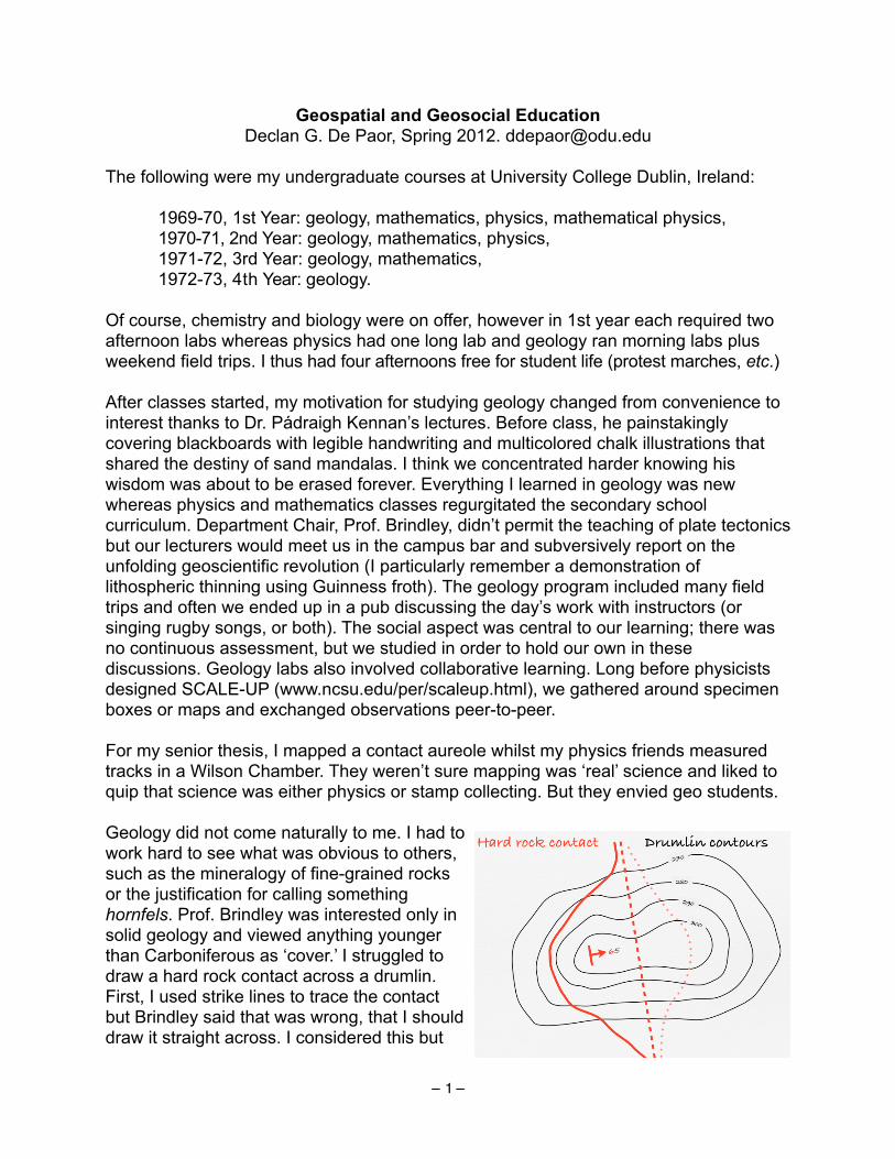
Geospatial and Geosocial EducationDeclan G. De Paor, Spring 2012. [email protected]
The following were my undergraduate courses at University College Dublin, Ireland:
1969-70, 1st Year: geology, mathematics, physics, mathematical physics,1970-71, 2nd Year: geology, mathematics, physics,1971-72, 3rd Year: geology, mathematics,1972-73, 4th Year: geology.
Of course, chemistry and biology were on offer, however in 1st year each required two afternoon labs whereas physics had one long lab and geology ran morning labs plus weekend field trips. I thus had four afternoons free for student life (protest marches, etc.)
After classes started, my motivation for studying geology changed from convenience to interest thanks to Dr. Pádraigh Kennan’s lectures. Before class, he painstakingly covering blackboards with legible handwriting and multicolored chalk illustrations that shared the destiny of sand mandalas. I think we concentrated harder knowing his wisdom was about to be erased forever. Everything I learned in geology was new whereas physics and mathematics classes regurgitated the secondary school curriculum. Department Chair, Prof. Brindley, didn’t permit the teaching of plate tectonics but our lecturers would meet us in the campus bar and subversively report on the unfolding geoscientific revolution (I particularly remember a demonstration of lithospheric thinning using Guinness froth). The geology program included many field trips and often we ended up in a pub discussing the day’s work with instructors (or singing rugby songs, or both). The social aspect was central to our learning; there was no continuous assessment, but we studied in order to hold our own in these discussions. Geology labs also involved collaborative learning. Long before physicists designed SCALE-UP (www.ncsu.edu/per/scaleup.html), we gathered around specimen boxes or maps and exchanged observations peer-to-peer.
For my senior thesis, I mapped a contact aureole whilst my physics friends measured tracks in a Wilson Chamber. They weren’t sure mapping was ‘real’ science and liked to quip that science was either physics or stamp collecting. But they envied geo students.
Geology did not come naturally to me. I had to work hard to see what was obvious to others, such as the mineralogy of fine-grained rocks or the justification for calling something hornfels. Prof. Brindley was interested only in solid geology and viewed anything younger than Carboniferous as ‘cover.’ I struggled to draw a hard rock contact across a drumlin. First, I used strike lines to trace the contact but Brindley said that was wrong, that I should draw it straight across. I considered this but
– 1 –

curved the contact in the opposite direction, arguing that ice had probably scoured the underlying bedrock into a spoon-shaped depression. Brindley responded: “Draw the contact straight across the drumlin, or is it that you think you’re the only student I have to supervise?” I decided I didn’t understand map making and resolved to research things I could measure, calculate, and be sure about.
After five years teaching in Galway, I moved to Johns Hopkins and offered mainly advanced courses. The audience for mathematical geology was not large, however, neither among students nor colleagues. I endeavored to make conference presentations about tensors entertaining and colleagues would respond “Loved your talk - didn’t understand a word of it - ha!” I decided the only way to promote my topics was to offer faculty workshops using lots of graphics. Visualizations helped folks grasp complex processes, while making and presenting them improved my own understanding.
My interest in computer graphics coincided with a ‘two-body’ career path ranging from contract-teaching a class of five majors at Harvard to team-teaching (with two physicists and two astronomers) in an auditorium filled with 425 students of Boston University’s Core Curriculum. Team-teaching with people Rutherford would have called scientists lead to many discussions on scientific method.
I also directed BU’s Field Camp at a time when GPS and GIS were revolutionizing mapping and came to the conclusion that mapping was key (pun intended). Geology describes places that change through time; it uses methods from Steno, Smith, Hutton, Walther, etc. The Principles in Lyell’s book are not derivable from Newton’s Principia. Earth cannot be reduced to physical particles bound by chemical bonds, because complexity emerges from their interaction and emergent complexity spawns chaotic patterns that require map making and map interpretation.
My Core Curriculum colleagues pointed to the role of prediction, e.g. Einstein’s 1915 prediction that starlight would be deflected by the Sun which was dramatically confirmed during a 1919 eclipse. However, that prediction then became an explanation of the past. Explanations of the past in geoscience are as valid as future predictions in physics.
Another hot topic for discussion was Popperian Falsification – the notion that a hypothesis could never be proved by repeated tests but could be falsified by a single negative test. This is not what Karl Popper actually said, and is not how science works. When a test result is negative, the hypothesis may indeed be wrong, or the test may be flawed. Whether a result is positive or negative, the test may be tainted by fraud. And if you test whether a test is valid, the problem becomes recursive. So how can you know?
Consider an analogy with jigsaw puzzles – a hobby my spouse Carol Simpson and I occasionally found time for before e-mail. Some pieces fitted uniquely but in regions of blue sky, alternative fits seemed equally possible. We turned these pieces over and examined the cardboard fabric closely. If pulp matched across jigsaw-cuts, we knew the fit was right. A similar approach works in geoscience. Wegener noted general coastline correspondence, then Bullard matched continental shelves in detail. Problems with the
– 2 –

Bullard fit, such as Iceland and Iberia were resolved on even closer inspection – Iceland was young, Iberia had rotated, etc. Thus, the key to resolving at least some working hypotheses is pattern recognition across a range of length and time scales. The proof is in the zoom-in!
As Carol pursued the dark art of academic administration, I continue to move (with the onset of middle age, finding a new spouse-job seemed marginally easier than finding a new spouse). WPI had no geology department so, invoking karma, they put me in physics. From there, I taught planetary science and geology for engineers. To my surprise, some of the smartest engineers disliked graphical solutions; rather than find the intersections of two planes by using a stereonet, they preferred to calculate with direction cosines and cross products.
Now in ODU’s physics department, I teach 375 non-majors (many from disadvantaged backgrounds) about the Solar System. Most have no understanding of the scientific, not to mention geoscientific, method. My research group creates, tests, and disseminates 3D models of specimens, block diagrams, etc., for use in Google Earth™. We’ve developed interactive virtual field trips and a mapping game in which students’ avatars explore Google Earth at various scales (why not?) and communicate via text messages that pop-up in one another’s placemark balloons.
I also teach with the Omniglobe™ and offer planetarium “field trips” to school children and the public. Digital full-dome projection of the planets and moons opens up new, immersive modes of both formal and informal education.
Geoscientists are not the only scientists who deal with places and patterns, but these are at the core of what we do. In today’s world, few students can learn the methods of geoscience in the field-based, highly social environment that many of us experienced. Our new challenge is to bring that social-learning approach to the domains of general education, adaptive learning, distance education, and peer-to-peer instruction.
Links: www.digitalplant.org www.odu.edu/~ddepaor
www.odu.edu/planetarium geosphere.gsapubs.org/content/8/2/491.abstract
www.sciencedirect.com/science/article/pii/S0098300410001755www.geosociety.org/gsatoday/archive/20/4/article/i1052-5173-20-4-4.htmwww.geosociety.org/penrose/10google.htmwww.geosociety.org/meetings/2012/sessions/keynote.htmNE GSA Workshop, Bretton Woods NH, 2013. Building Google Earth Geologic Maps and Information Systems for Desktops, Laptops, and Mobile Devices.
– 3 –

Introducing the Methods of Geoscience to Physical Geology Students Beth Dushman As a geology instructor at a community college, I teach mostly non-majors students in my Physical Geology lectures and labs. These classes may be these students’ only introduction to science at a college level, and it may be the first science class they have had in years. These students are often science-phobic and lack the confidence to engage in discovery learning. At the same time, I often have a few majors in my classes. Thus, my challenge is to teach the majors geoscience skills they will need for future classes, while engaging the rest of the class in activities that will improve their understanding of basic science and geology. The most important methods of geoscience that I think students should learn in my classes are critical reasoning, observation of natural phenomena, synthesis of multiple ideas, the basics of how the scientific method is applied in geology, and communicating scientific information. I use a variety of strategies to teach these science methods in my lecture and laboratory classes. I start each semester with an overview of the scientific method, and compare the traditional 5-step process (observation, hypothesis, experimental design, data collection and analysis, and conclusion) to how the scientific method is applied in Geology. For example, many students learn that science is conducted through experiments with strict controls and a few variables. Geoscientists, however, lack an extra planet to use as a control when we study the Earth. Instead, we make approximations in labs and using computer models, but often data are gathered through field observations. As the class investigates various topics in geology, I explicitly identify ways in which the scientific method (and other geoscience methods) has improved our understanding of the Earth. The development of the theory of plate tectonics works an an excellent example. We discuss the initial observations, gathering of evidence, original ideas and criticisms about continental movement, through the discoveries that resulted in the theory of plate tectonics. Throughout the semester, I encourage students to ask, “how do we know that?” about any topic. Each time this question is raised, it presents an opportunity to share the observational and analytical methods that laid the foundation for our current understanding of that geological phenomenon. Of all the science methods my students should learn, critical reasoning skills are the most important. Critical reasoning is essential in most fields, and yet students are often overwhelmed by any problem that requires effort beyond simple memorization and regurgitation. This problem may be compounded by the perception that science is too hard, or that students are “bad at science.” As a way to demonstrate to my students that they can be competent problem solvers, I work with them to break problems down into simple steps, and then to integrate those steps to make a whole story. For example, while interpretation of a simple stratigraphic section may be daunting at first, students gain confidence as they decipher the geological history of that area. In my lab classes, students apply some of these methods through hands-on experimentation. For example, students practice observation of natural phenomena in lab exercises using stream tables and Google Earth, while simultaneously synthesizing information from lecture, lab, and observations. As part of the lab where students experiment with small stream tables, students are asked to describe how the models succeed or fail at approximating Earth processes. This

question helps to engage students in a discussion of the limitations and advantages of using models in geoscience in general. Another important geoscience method is clearly and effectively communicating scientific information. My students complete a writing assignment for which they must find and evaluate sources of scientific information, then summarize into a coherent synopsis of a significant geologic event. This exercise introduces students to how scientists collect, interpret, and communicate their data. While the students are not conducting original research for these assignments, this project may be their first introduction to scientific reseach. Furthermore, by delving deeper into the information available for a given geologic event, students begin to recognize the differences between scientific media and popular media. For majors, this project gives students an idea of where to start looking for science resources and introduces them to the peer-review process. For nonmajors, students gain an appreciation for how scientific information is developed and disseminated to public. Prior to taking this class, many students were only exposed to geology when natural disasters occurred, resulting in a somewhat skewed perception of the role geologists play in forecasting or mitigating these events. By developing a deeper understanding of the ways in which geoscientists study the earth, students are better able to assess the information they see in the mainstream media. To this end, we discuss methods geologists employ to study hazards, such as seismic surveys, mapping of earthquake foci, gravitational studies, and volcanic hazards monitoring, and how geologists describe risk using recurrence intervals. Then, when we address the limitations of these methods as applied to natural hazards, students recognize why we cannot predict or prevent many geological events. Lastly, any discussion of how science works should include a discussion of how scientific thought changes over time. I emphasize that while geologists do have a very strong framework for contextualizing most Earth processes-- Plate Tectonics-- there is still a lot about how the Earth works that we do not yet understand. As students consider applications of geoscience methods to these unanswered questions about the Earth, they gain an appreciation for ongoing geological research. Even better, some are inspired to become geoscientists themselves.

Lithic Literacy and the “Forensic” Methods of Geoscience James R. Ebert, Department of Earth and Atmospheric Sciences
State University of New York, College at Oneonta
My approach to teaching the methods of geoscience is founded on two related expressions of a single idea, which I use in nearly all the courses I teach. The first expression is in the form of a question that I often pose to my students: “What do we know and how do we know it?” It is the “how do we know it” part that encompasses the methods of geoscience. The second expression is borrowed from Murray (2004) – it is the notion that all geology is forensic geology. I do not mean the legal aspects of forensic, rather I mean the association that the word has with the reconstruction of events and processes from the physical evidence of those events and processes.
So, how do we know what we know and how can we reconstruct events for which there are no eyewitness accounts? The clues are “written in the rocks.” However, before students can read the story they must develop what I call “lithic literacy.” By this, I mean that it is first necessary to be able to recognize the clues before we can interpret them. In my classes, I stress the centrality of observation in the solution of geoscience problems. Bill Metzger, with whom I studied historical geology and stratigraphy as an undergraduate, often said, “Interpretations come and go, but a good description lasts forever.” In developing lithic literacy, it is not only important that students make careful observations, but they must also come to realize that some observations are more useful than others are. For example, the texture of any rock provides clues to the processes that formed that rock. Observations of texture are generally more useful than observations of color, which may be influenced by weathering or the presence of trace elements.
Once students gain some facility with observation, I introduce interpretation by starting with modern analogs that are familiar to most students. Because I teach courses in Earth History and Sedimentary Geology, I use sedimentary structures. Most students have seen ripples and mud cracks in modern settings, so it is not a giant intuitive leap to interpret such structures when they occur in rock. Students quickly recognize that these structures are records of processes, unwitnessed, but which undoubtedly occurred. This is the geological version of “Who done it?”
From sedimentary structures, we reconstruct processes. Processes lead us to environments and from environments to paleogeography. This inductive approach differs somewhat from the other sciences in that we are working from multiple specific examples and deriving general principles. Other sciences tend to use a more deductive approach. On the other hand, once paleogeographic and stratigraphic frameworks are established we can make predictions to unexamined areas. Can we project how thickness, facies, etc. will change in these areas? These predictions are hypotheses, which are testable by observations in the unexamined areas. In this respect, the methods of geoscience do not depart radically from the methodologies employed by other sciences. However, geologic systems are inherently complex and commonly messy, unlike much of chemistry and physics, for example, in which controlled experiments, which manipulate one variable at a time, are the norm. Students commonly struggle with the uncertainty inherent understanding in complex, messy geologic systems. All scientific knowledge is tentative, of course, but students are not comfortable with the notion that their interpretations might be wrong. Further, they do not like the notion that there are other, possibly better explanations, which they have failed to envision. Part of my task is to help students develop some level of comfort with this uncertainty.
References Cited
Murray, R. C., 2004, Evidence from the Earth, Mountain Press, Missoula, MT, 226p.

6/19/12 9:10 AMWant better-prepared students? Teach teachers to think like geoscientists
Page 1 of 1http://serc.carleton.edu/integrate/workshops/methods2012/essays/ellwein.html
Integrate > Workshops > Teaching the Methods of Geoscience > Participant List > Want better-prepared students? Teach teachers to think likegeoscientists
Want better-prepared students? Teach teachers to think like geoscientists
Amy Ellwein, Geology Program, Western State College of Colorado
Among other courses, I teach inquiry-based, integrated lab-lecture science courses for pre-service elementary teachers withlimited enrollment. As opposed to geoscience majors, this audience typically has a weak background in science and math andconsiderable trepidation about learning, and ultimately teaching, science and math. I also develop and teach field-basedprofessional development geoscience courses for in-service K-12 teachers, which is an audience that has experience teaching inK-12 settings and is seeking deeper knowledge and skills. In many ways, teaching geoscience courses for teachers is quite similarto teaching courses for geoscience majors; the same challenging concepts are highlighted and all students work to gain conceptualknowledge, discipline-specific skills, and an understanding of the nature and processes of science. However, one major additionalgoal in geoscience courses for teachers is that learners must sufficiently and confidently master major geoscience concepts andmethods in order to effectively teach geoscience.
I find that establishing a highly interactive student-centered course is critical to teaching the methods of science. Also critical arefostering mutual respect, enthusiasm for experimentation, and acceptance of failure as an important step in deep learning. In mysmall courses, I've found that combining science notebooks with reflective writing promotes these critical course components. Mystudents use notebooks daily to learn and model some of the processes of science: recording data, observations and questions;building and testing hypotheses; summarizing results, etc. But they also use notebooks to identify and challenge their currentlyheld preconceptions, build on their existing knowledge, monitor their ongoing learning and thinking about concepts or methods,and reflect on course activities and their learning progress (e.g. Reflective Writing Prompts).
Careful, standardized, and repeatable field observations, in the context of conceptual or numerical models, are the foundations forwhat we know about the Earth and Earth Systems (and how we know it), but my students often don't consider their observationsas scientific data. Teaching students to make quality observations in the field, to find patterns in their data, and to clearly separateobservations from interpretations, are important activities that result in skills that are highly transferrable to other sciences andscientific thinking in general. The related concept of multiple working hypotheses is also very difficult for many students, in partbecause asking scientific questions is daunting for many novices, but is key in understanding how to "think like a geologist". Ithink it is very important that pre- and in-service teachers have ample opportunity to make basic field observations and interpretgeologic data in order to understand, use, and ultimately teach, the methods of geoscience in their own classrooms.
Supporting AttachmentsWant Better-Prepared Students? Teach Teachers to Think Like Geoscientists (Acrobat (PDF) 60kB May14 12)
Search the Site Go

Geoscienceodd‐(wo)manoutHollyGodseyMyexperiencesinteachingtodatehavebeenanythingbuttraditional.TheyincludeacoupleofTApositions,fieldcampfornon‐geosciencemajors,graduatestudentseminars,teachinghigh‐schoolsstudentswhilefloatingthroughCataractCanyonoftheColoradoRiver(Quick!Namethetypeofrockthatweareabouttosmashinto!),andvariouseffortsinmyson’selementaryschoolclassrooms.Forthepasteightyears,IhavemanagedanddirectedseveralscienceeducationprogramsincludingtwoNSFGK‐12programs,anNSFNoyceTeacherFellowshipprogram,andaMastersofScienceforSecondarySchoolTeachersprogram.ThroughallthistimeIhaveorganizedandsatthroughcountlessteachingandpedagogyseminars,createdlessonplans,taughtinquiry‐basedmethods,mentoredgraduatestudentsontheirteaching,leadsessionsoneffectivecommunication,createdteachingkits,andmanagedtoNEVERteachacourseingeology.However,thatisallabouttochangeformeasouruniversityisembarkinginanewprograminEarthScienceTeachingandIamtheoneleadingthecharge.IamthrilledthatIhavetheopportunitytoparticipateintheGeoscienceTeachingMethodsworkshopandlearnfromothersthathavebeendoingthisforyears.Iwillhavemyfirstopportunitytoteachinaformalsettingthisfallinrocksandmineralscourseforteachers.Ihaveseveralgoalsformycareerasateacherofgeoscience,somearepersonalgoalsandsomeareintendedtoaffectachangeinhowEarthscienceisperceivedintheUtahstateeducationalsystem.Personally,IwanttodowhateveryteacherwantstodoandthatistoexciteandengagestudentsinEarthscience.Iwanttolearntoclearlyexplaindifficultconceptsandeffectivelycommunicatehowtheseconceptsarerelevanttotheworldwelivein.Iwanttoengagestudentsinminds‐on,andinquiry‐basedactivitiesthathelpthemdeveloptheirownpathwaystounderstandingandgivethemthetoolstointegratemultipledatasetstoformacoherentmodelofEarthprocesses.InUtah,EarthScienceistaughtin9thgradeandisconsidereda“default”courseforthosestudentswhodonothavetheaptitudeforbiology,physicsorchemistry.TheteachersthatteachEarthSciencetypicallyhavelittletrainingingeology(youcanbeendorsedtoteachitwithjustonegeologyclass)andteachitasan“extra”totheirbiologyandchemistrycourses.Therefore,thesubjectistypicallytaughtlecture‐stylewithverylittleinquiryorresearch‐basedmethods.Asgeoscienceprofessionals,weallunderstandthatthemethodsofgeoscienceresearchareverydifferentthanthoseofbiologyorchemistryandthatthestandard“science‐fairmodel”doesnotworkwellforthisdiscipline.Teachersdonotunderstandhowtoteachgeoscienceasaresearch‐basedsciencewhentheycan’tdoarepeatableexperimentinatesttube.Thismisconceptionhaspermeatedallthe

wayuptotheStateBoardofRegentswhodenyRegentsScholarshipstostudentswhotakeEarthsciencebecausetheydonotrecognizeitasaresearch‐basedscience.Ironically,geoscienceistheultimateresearch‐basedscienceandrequiresconceptsfrommath,chemistry,biologyandphysicstogainacompleteunderstandingofEarthprocesses.EarthScienceshouldbeviewedasa12thgrade“capstone”coursethatothersciencesaretheprerequisitefor(and,infact,wearepilotingsuchacoursethisfall).Myultimategoal,therefore,istotrainteacherstoteachEarthscienceasEarthscienceisdoneandeventuallyraisethebarforgeoscienceteachinginmygeologically‐giftedstateofUtah.

Thoughts on Teaching the Methods of Geoscience Kyle Gray – University of Northern Iowa
For the past three years, I have been teaching at the University of Northern Iowa – a four-
year, public university with a strong emphasis on teacher education. Like many of the institutions represented by participants in this workshop, UNI was formerly known as a teacher’s college (Iowa State Teacher’s College) and still maintains a state and regional reputation as “the place to go to become a teacher”. I am housed within the Earth Science Department but also teach courses for the secondary Science Education program.
I am a relative new-comer to the field of teaching the methods of geoscience. Over the past year I have read several papers describing the key differences and talked with several people in our community about this topic. From my perspective, geoscience inquiry has historically been about observing some phenomenon the natural world (e.g. look at the rocks at a given locality) and determine how or why that phenomenon happened (e.g. determining how these rocks formed). Put another way, geoscience inquiry often takes the form of “What’s over there and how did it come to be that way?” This is an inductive approach to scientific inquiry that often includes a historical questions (When did that happen?). This methodology is shared by other disciplines including astronomy, meteorology (both of which could be included within the term geoscience) and stands in stark contrast to the deductive “science fair model” of science where an investigator always proceeds in order through the steps of hypothesis, experiment, results, and conclusions.
My primary teaching responsibility is an Earth Science content course for pre-service elementary education majors. This is an inquiry-based course with students who are primarily freshmen and sophomore women who have avoided taking science in high school and have not had an Earth science course since middle school. At the beginning of each semester I have the students write a reflection paper on their prior experiences in learning science as well as their views of the ideal way to teach science. At the end of the semester I have them reflect on what they have learned and areas in which they have grown in their understanding of the nature of science. I also collect data on their beliefs towards teaching science. Each semester, my students consistently report that they view science as a single, monolithic process that must be rigorously followed. One student even described how she originally thought that scientists only ‘did” science when they were using the periodic table. This rigid structure turns many students off to science. By the end of the semester, many express their joy in learning that scientific inquiry is more than conducting experiments.
As I reflect on my teaching, I realize I have been incorporating explicit teaching on the methods of geoscience in my courses. In my inquiry course, my goal is to give my students multiple opportunities to engage the data or phenomenon so they can practice those science process skills of collecting and analyzing data as well as using those data to construct explanations based on known scientific principles. For example, when talking about soils, I have students observe photographs of different types of soils from around the world and then use their observations to identify similarities between soil types. These similarities are then used to define a soil. Another example is my lesson on the behaviors of meandering streams over time. The students observe geomorphic changes in a stream table and infer the general rule for erosion along cut banks. Then they observe a series of Google Earth images from the Wabash River

showing numerous abandoned meanders and ox bow lakes and use their previously developed model to interpret the river’s history. Even though I have included the nature of geoscience inquiry in my courses, I am looking forward to finding new ways to improve this aspect of my teaching.
Besides reflecting on my own teaching, I have thought about the challenges and barriers we face in communicating the methods of geoscience inquiry and geoscience thinking. The first is the diversity of student populations with whom we are teaching. Geology majors need to a different and deeper skill set than a pre-service elementary teacher. While there will certainly be some overlap in the lessons and activities used to teach each group of students, my guess is that some activities may be needed that specifically target only one group. Second, teaching to think and act like a geoscientist requires significant time outside of the classroom making direct observations of the natural world. Looking at hand samples of limestone and sandstone is not the same thing as standing at an outcrop containing these rock types. Even looking at a picture is not the same experience. From such field experiences, students should come to understand that all products of geoscience inquiry (e.g. geologic maps) began as human interpretations of field relationships like those shown at outcrops. Third, geoscience is a context-specific, place-based discipline that cannot be replicated in all classrooms. Students conducting a chemistry experiment should have the same experience in both Alabama and Zanzibar. For laboratory disciplines like chemistry, place does not matter, but in the geosciences, the location of the classroom greatly influences student learning. Students in Iowa have multiple personal experiences with tornadoes but cannot easily visit a volcano. Similarly, students in the Pacific Northwest have access to volcanic rocks and volcanoes but students in the Midwest do not. These challenges are magnified for those trying to teach in an online medium. Fortunately, advances in simulations and geospatial technologies (like Google Earth) can compensate for the lack of experiences by our students, and I wonder if tools like this can convey the unique perspectives that geoscientists possess.
In the end, I see one element that runs throughout these issues, that is the need for students to directly practice doing geoscience in a real, authentic environment whenever possible. Some localities may provide a wealth of experiences whereas others may provide extra challenges. Also, given the state of many department budgets, it may not be possible to get out into the field very often, so activities that work in campus settings or within the classroom may play a critical role in teaching these skills to our students.
It’sscarytofeeluncertainKimHannulaAboutamonthago,Igotaflyerinthemailadvertisingsoftwaretoaidinthree‐dimensionalvisualizationofgeologicstructures.“Reduceyouruncertainty!”I’mnotsurethat’swhatmystudentsneed.Mydepartment(atapublicliberalartscollege,withnograduatestudents)teachesstudentshowgeoscientistsdosciencebygettingthestudentsinvolvedincollectingandinterpretingdata,startingwithclassprojectsasfreshmenandculminatinginseniorthesesbasedonindependentresearchprojects.MyintroductoryEarthSystemsScienceclasscollectsandinterpretsdataonasmalllocalriver.Mysophomoremappingclasswritesareportthataccompaniestheirfinalmappingproject.MyjuniorStructuralGeologyclasswritesreportsthatseparatetheirobservationsfromtheirinterpretationsforeveryfieldlab.Ourseniorsproposeresearchprojectsduringtheirjunioryear,collecttheirowndata,andpresenttheirworkaspapersandprofessionaltalksattheendoftheirjunioryear.Andmycolleaguestakesimilarapproachesintheirclasses.Thissemester,ItaughtAdvancedStructuralGeology,anupper‐levelelectivetakenbyabouttenjuniorandseniorundergraduates.It’stheonecourseinwhichIcanteachnearlyanythingIwant,andthissemester,thecoursewasinspiredbyapairofarticlesbyClareBondandcolleaguesatMidlandValley,astructuralgeologysoftwarecompany.Clarehadshownasyntheticseismicsectiontogeologistsatconferencesandaskedthemtointerpretit,andfoundthatonlyafractionofpeoplewithrelatedexperiencehadinterpreteditcorrectly.Themostsuccessfulapproachesinvolvedthinkingaboutthesequenceofeventsthatformedthestructures,ratherthansimplyidentifyingthegeometry.MidlandValleycreatessoftwarethatallowstestingofstructuralgeologyhypothesesthroughvariouskindsofmodeling,andatconferences,I’veseenClarearguethattheirsoftwarecanbeusedtoimprovegeologists’understandingofhiddenstructures.Idecidedtofocusmycoursearoundtheirsoftware,andaroundtheuseofmodelinginstructuralgeologyingeneral,inpartbecauseIthoughtClare’sargumentswerecompelling,andinpartbecauseIwasconcernedthatourundergraduatesdon’tgivealotofthoughttowhattheyaretryingtoaccomplishwhentheyusespecializedsoftware.ButIdidn’tjustwantthestudentstolearntousesoftware–Iwantedthemtomakeahabitofthinkingaboutthetoolsthattheyusetosolveparticularproblems,tothinkabouttheunderlyingassumptions,tothinkaboutwhetherthesoftwarewastestingthestudents’conceptualmodelsoftheirstructures,orwhethertheywereusingthesoftwaretoconfirmthingsthattheywerealreadycertainweretrue.Thefinalprojectfortheclasswastoapplythesoftware(oranothertypeofmodelingsoftware)toastructuralgeologyproblem,andtowriteapaperthatdiscussedboththeirresultsandtheirassumptions.

IgradedthefinalpapersforbothAdvancedStructureandmyintroductorycourselastweek,andasIreadthem,Iwonderedwhethertheprocessofcollectingandinterpretingdatareallyhelpedthemunderstandhowscienceworks.Inpaperafterpaper,theintrostudentstoldmethattheriverbehavedexactlyinthewaythattheyexpected(eventhoughtherewereseveralstrangeresultsinthedata–forinstance,anunusuallyhighdischargemeasuredatonesite,pairedwithsurprisinglylowturbidity).Inpaperafterpaper,myAdvancedStructurestudentstoldmethatthesoftwareworkedbecauseitreconstructedtheircross‐sectionscorrectly,andthattheircross‐sectionsmusthavebeenrightbecausethesoftwaresaidso.Allofthestudents,introandupper‐level,weresocertain...withoutgoodreasontobe.Itmademethinkthatmaybethiswholeprocessofscienceisjustplainhardforhumans.Notbecausewehavetodomathorphysicsorchemistryorscaleshearcliffswhilecarryingthirtypoundsofrocks,butbecausewedon’tlikeuncertainty.Wedon’twanttolookforthosethingsthatmightshowusthattheworlddoesn’tworkthewaywethinkitdoes.It’sscary.It’sstressful.Andwe’rerewardedforbeingright,notforquestioningourselves.Andyetit’sthatquestioningthatmakesscienceavaluablewaytounderstandtheworld.Ifsciencebringsusclosertoanunderstandingofthenaturalworld,it’sbecausesciencetestsitsassumptions.Butifdoingthekindofworkthatscientistsdoisn’tenoughtocreateahabitofopen‐mindedness,awillingnesstoexamineone’sassumptionsandbeawareofhowthoseassumptionsshapeourresults,whatshouldwe(asteachers)do?Idon’tknow.Here’sanexampleofsomethingelsethatIdid,somethingthatIthoughtworked,butwhichprobablywasn’tenough:ItookmyAdvancedStructureclassonafieldtripoverspringbreak.Inthemiddleofthefieldtrip,Ihadthemmapinanareawheretheyknewtherecouldbenormalfaults,thrustfaults,strike‐slipfaults,folds,overturnedstratigraphy–almostanythingpossibleatshallowlevelsofthecrust.Theyhadseenthebasicstratigraphy,andtheyhadaerialphotosandcompasses.Isentthemouttofigureitout.Afteraboutanhour,Iwentlookingforthegroups.Someofthemthoughttheyhadfiguredouttheanswer.Mostofthemwerewrong,andItriedtogetthemthinkingaboutwhatobservationstheyneededtomaketotesttheirmodelsandthinkaboutotherpossibilities.Otherstudentswerejustconfused,andfrustrated,andneededcoachingtostartbrainstormingpossibilities.Isentthemalloffagainwithsketchesofpossiblecross‐sectionsandpredictionsthateachcross‐sectionimplied.Inthevanattheendoftheday,Itoldthemthatbeingconfusedispartofthefieldgeologicmethod.“Gooutside.Walkaround.Getconfused.Sketchpossibilitiesfor

whatmightbegoingon.Walkaroundsomemoreandseeifthosepossibilitiesmatchwhatyousee.”ButIthinkthatintheend,theyreallywantedtobecertainthattheywereright,whethertheevidencewasstrongenoughfortheircertaintyornot.

Geosciencemethodsappliedtoreal‐worldproblemsKathleenHarper,UniversityofMontanaGeosciencesManystudentscomeintomyPhysicalGeologycoursewiththeimpressionthattheyaregoingtobeaskedtomemorizealonglistofunfamiliarwordsandlearnspecialfactsaboutrocks.Mostofthestudentsenrolledinthislarge‐enrollmentlectureandlabcoursearetakingittofulfillageneralsciencerequirementratherthanplanningtomajoringeoscience.Fewofthemknowmuchaboutgeosciencecomingintothecourse.Myhopeisthatbytheendofthetermtheywillfeelthattheyhavelearnedhowobservation,measurementandmodelingallowgeologiststosolveproblemsandanswerquestions.Ialsowantstudentstorecognizethatsomeoftheproblemsthatgeologiststakeonarevery“relevant”toeveryoneonearth–notjustgeologists.Problemssuchasrisksofearthquakes,volcaniceruptionsandenergyandmineralresourceutilization.Iamalwaystryingtoaddtomyquiverofinterestinggeology‐basedexamplesofhowtheprocessofscienceworks.Characteristicsthatmakeengagingexamplesseemtobeonewithrelevancetoregionalissues.Afewexamplesareproblemsinvolvingthecontamination,primarilyofsurfaceandgroundwater,thatisthelegacyofmininginMontana(suchastheexampleactivityincludedhere);energyresourceissues,suchascoal,oilandgasextraction,“fracking,”andusingoilsands;andpredictionofearthquakesandvolcaniceruptionsinthePacificNorthwestandYellowstoneregion.IalsolikeissueswithglobalrelevancesuchastheimplicationsofchangesinbehavioroftheGreenlandIceSheet,orusingpaleogeographicreconstructiontounderstandwhytheMiddleEasthassuchvastoilandgasdeposits.Whenstudentscanseetheapplicationofknowledgetoproblems,theycanbegintobuildanunderstandofwhatgeoscientists–andothertypesofscientists–reallydoandwhatmakesthempassionateaboutscience.

6/18/12 3:28 PMCuriosity based learning and self-education
Page 1 of 1http://serc.carleton.edu/integrate/workshops/methods2012/essays/hidalgo.html
Integrate > Workshops > Teaching the Methods of Geoscience > Participant List > Curiosity based learning and self-education
Curiosity based learning and self-education
Paulo J. Hidalgo, Geosciences, Georgia State University
I have always admired educators who were able to transform my lack of enthusiasm towards a subject into that of mesmerizinginterest. Educators such as the ones I am referring to not only changed my career selection but have continued to influence andrevitalize my appetite for knowledge and higher research standards. Like them, I believe that my role in the classroom is that of ainstigator of scientific curiosity. Somebody that could bring back the primal curiosity embedded in human nature by encouragingstudents to self-educate.
I have an inquisitive, curious and precocious 3 year old daughter. Because of my scientific training, I tend to observe and analyzeeverything that she does, says, or observes. I have come to realize that she is naturally curious like many other children of her age.She continuously inquires about her surroundings and later generates concepts and models to describe the world around her. Ihave realized that commonly she tests these concepts over and over, modifying previous conceptions when needed. This I believe,is an endless curiosity based learning cycle. More importantly, this process is roughly akin to what we describe as hypothesistesting and the scientific method. From birth our children are wired to be more than passive observers. Their brains are free ofpreconceptions and are predisposed to perceive the environment with great amazement and inquisitive minds. This is possiblywhy children are able to learn by simple observation and listening, skills such as: walking, climbing, jumping, talking, learningnew languages, physical properties of objects, psychology of interpersonal relations, etc. Children manage to learn all of thiscomplicated plethora of complex skills from no one. It is by simple free play and their insatiable curiosity that they learn about theworld around them.Later in live, the insatiable minds are send to structured schooling where the self-inquiry self-education process could cease tooperate.
George Bernard Shaw used to say:
"The only time my education was interrupted was when I was in school." and
"If you teach a man anything, he will never learn."
I believe that our role as educators is to try to reverse the "damage" that many years of structure schooling have done in ourstudents minds. I believe that this is more easily done by creating a class environment that is conducive for students to teachthemselves and others. But overall, by creating a community of supportive and collaborative inquiry within the classroom that isbased in the common phenomena that we observe in the word around us.
Crucial to this process is to provoke the students curiosity by making them produce their own observations, and their owninferences and theorems based on the observations. Later, our role is to present the current state of the subject by introducingtheorems and paradigms (carefully for the faint of heart), and empirical concepts that can be integrated into their own lifeexperience. In the opinion of many developmental psychologist, curiosity is an important piece in a complex puzzle ofdispositions that are necessary for lifelong learning. In that sense, our primordial activity as instructors should be to facilitatecuriosity in our classrooms and evaluate how well we are developing lifelong learners by continuously assessing and revivingstudent's natural curiosity.
Supporting Attachments
Search the Site Go

Learning geoscience by doing geoscience – by Paul Kelso, Lake Superior State University
As is the case with many faculty, my teaching methods and strategies have evolved over the years. I learned geoscience primarily though traditional lab and lecture and this is how I initially structured my classroom. I lectured, did a variety of demonstrations and students applied concepts though laboratory activities and homework exercises. This appeared to be successful as students generally preformed well on assignments and exams.
After teaching for a number of years I became frustrated with student retention of material and their application of previously learned concepts to new situations. When teaching upper division undergraduate geology classes I often ask students to apply concepts that they learned in a previous class. I don’t know if you have ever had this experience, but students would often tell me, “no we didn’t study that in such and such class.” Then I would inquire with colleagues and they would say yes we covered that material. Students would even tell me, “no you didn’t cover that topic in class the previous year.” After discussion of particular examples related to the topic that we had previously discussed and then they would begin remember that they had heard that before, but often had difficulty seeing the connection and applying these concepts to the new situation in their current class.
I have modified my teaching to try to address student’s retention and application of concepts. Now student activities often model the professional geoscience experience, thus students practice working as geoscientists. This has involved a redesign of my courses so that they focus on the process of doing geoscience rather than the traditional discrete, content-centered courses. Courses now are problem-centered, concentrating on important geologic problems and emphasizes sub-discipline integration. Courses are structured to integrate fundamental geoscience concepts from sub-disciplines presented in the context of sequentially ordered problems that reflect increasing structural complexity, different depositional regimes, and different igneous and metamorphic petrogenetic models. Most courses have field component to promote in-depth understanding of real world geologic problems. Individual student projects are designed to promote the comprehension of fundamental concepts through its application to solve significant geological problems. The application of concepts to answer questions students have from their field based projects motivates students to learn, internalize, and apply concepts.
This course pedagogy is based on these key principles: learning is constructivist, experiential, investigative, inquiry-based, and collaborative within a community of student-scholars. Constructivist teaching/learning theories are applied that emphasize active learning which helps students construct a strong knowledge framework and enhances motivation, learning and retention, problem solving, critical thinking and communication skills. Active cooperative learning increases conceptual understanding and student achievement and helps students overcome misconceptions. In our paradigm, individuals actively construct new knowledge by building on what they already know while hopefully discarding misconceptions. Students develop higher level thinking skills and construct new knowledge by participating in a community of learners, by making observations and developing a conceptual understanding, while learning terms and facts, and by actively explaining their understanding of concepts. Learning progresses as students work collaboratively, discuss their progress, encounter different interpretations, bounce ideas from each other, and challenge each other’s conclusions.
The focus on field based projects requires students to: make their own observations, decide what information is important to collect and how to collect it, often collect a variety of information related to different geoscience sub disciplines, revisit key concepts at increasing levels of sophistication on succeeding projects, decide what is not important, decide how to focus their time and energy give the project objectives and time constraints for the project. The identification of real problems for the students to address provides a context for the problem, generally requires students to consider concepts from multiple sub disciplines, and provides student motivation to solve the problem. This has resulted in improved student retention of materials and it application to new situations as they practice this on multiple projects.
Many of the projects are designed so students are involved in all aspects of a project. Thus the students must propose and justify the method to solve a problem, design the study, carry out the study through the collection of data, process and interpret the results, and present the conclusions/recommendations both written and orally. Thus projects model the work that a geoscientist might undertake working in industry or academia.
Developing activities where students learn the methods of geoscience by modeling the behavior of professional geoscientist has resulted in a significant change in what students learn and how they apply this knowledge to geologic problems. Students are now learning geoscience by doing geoscience. It is exciting watching students as they learn to answer and ask questions, as they tackle increasingly sophisticated problems and as their confidence grows as they develop as geoscientists.

Taught traditional geology lab lectures for years
Weakness –
Retention of concepts
integration of concepts from different disciples/courses to solve problems
differs substantially from traditional curricula in which knowledge is too often compartmentalized and students have difficulty making important connections among sub-disciplines.
Students learn by doing
requires student problem-solving and critical thinking, utilizes active learning strategies that model scientific endeavor, provides a focus for sub-discipline content application
Model professions geoscience experiences
Real world experiences solving geoscience questions
Students practice integrating information from multiple sub disciples to solve problems
Revisit concepts a increasing levels of sophistication in multiple courses
Focus on field based learning
Require integrating a variety of information
Collected information is often from multiple disciplines
Students have to learn what is important, what to focus their attention on

Whydoweteachgeosciencetonon‐majors?KaatjeKraftInarecenthomeworkassignmentastudentsubmittedaboutthenatureofgeoscience,hecitedawebpagethatdiscusseswhethergeologyisarealscienceornot(http://www.quantumpie.com/the‐big‐bang‐theory‐sheldon‐asks‐is‐geology‐a‐real‐science/).Theblogdiscusseshowgeologyisdifferentfromsomeoftheothertraditionalsciencesbecausewecan’treplicateEarth,soourlaboratoryisnotoneinwhichwecancontrolthevariables.Ithinkthisissocriticalforourstudentstoreallyunderstandwhatmakesgeologysochallenging,butalsohowtheprocessofsciencecanstilloccurthroughtheuseofmodeling.Manyofourstudents’understandingofmodelsislimitedtothinkingofphysicalrepresentationsofobjects(i.e.,globes,science‐fair‐stylevolcanoes,etc…).Theydonotunderstandorrecognizethatmodelscanbepowerfultoolsforexplainingandpredicting(or“retrodicting”asisoftenthecaseingeology;Orion&Ault,2007).Thisbecomesacriticalaspecttothequestionofwhyweteachintroductorygeosciencestoanon‐majorpopulation.Themorewecansupportourstudentswithopportunitiestoexplorethepurposeandlimitationsofmodelsthroughinterpretingandusingmodelstogeneratetheirownpredictions,themorewecansupportourstudentsabilitytorecognizethepowerofmodels.Whentheyhearaboutmodelsforclimatechange,volcaniceruptionhazards,orrisk‐factorsfordifferentgeoscientificphenomena,themoretheymaybewillingtoacceptthatascientificmodelisourbestwaytoexplainingandpredictingfuturephenomena.Butjusttellingthemisn’tenough.StudentsneedtoEXPERIENCEworkingwithmodelsanditmustbeexplicitlytiedtotheconstructofmodels.Itisextremelydifficultforstudentstolearnaboutanyaspectoftheprocessofscienceandimpossibleifitisn’tmadeexplicit(Lederman,2007).Ifwewantourgeneraleducationstudentstobe“scientificallyliteratecitizens,”weneedtoseriouslyexaminewhatisimportanttoaddressinanintroductoryclass,howweapproachthetopicsandwhatisemphasized.Inallofmyintroductorygeosciencecourses,Iweavetheprocessofgeoscienceasacommonthemethroughwhichthemechanismofthecontentistaught.Inmydisastersclass,Iaskstudentstoreflectonhoweachtopicrelatestotheprocessofgeoscienceinspecificallytargetedreflectionsinthecontextofcasestudies(Kraft,2012).Inmyphysicalgeologyclass,Iintegratetheimportanceofmodelingthroughouttheclass(seethesampleactivitywiththissubmission).Inmyhistoricalgeologyclass,Iemphasizetheprocessofretrodictionthroughoutthecourse.Andyetwithalloftheseapproaches,learninggainstowardunderstandingtheprocessofgeoscienceislimited(vanderHoevenKraft,inpreparation).Andyetanygainsarecriticalsincemanyofourintroductorystudentsareexposedtooneortwoscienceclassesincollege,andyettheymakesomeofthedecisionsatacitizenlevelthatmayimpacthowweareabletoaccomplishgeologicresearch.Citations

Kraft,K.J.,2012,Encouragingstudentstothinkabouthowtheythink:IntheTrenches,v.2,p.6‐8.Lederman,N.G.,2007,Natureofscience:Past,present,andfuture,inAbell,S.K.,andLederman,N.G.,eds.,HandbookofResearchonScienceEducation:NewYork,Routledge,p.831‐879.Orion,N.,andAult,C.R.,2007,LearningEarthSciences,inAbell,S.K.,andLederman,N.G.,eds.,HandbookofResearchonScienceEducation:NewYork,Routledge,p.653‐687.vanderHoevenKraft,K.J.(InPreparation),Canstudentslearntheprocessofscienceinanintroductorygeosciencecourse?

6/18/12 3:31 PMShould we teach how to cope with uncertainty and incomplete data?
Page 1 of 1http://serc.carleton.edu/integrate/workshops/methods2012/essays/linneman.html
Integrate > Workshops > Teaching the Methods of Geoscience > Participant List > Should we teach how to cope with uncertainty andincomplete data?
Should we teach how to cope with uncertainty and incomplete data?
Scott Linneman, Geology, Western Washington University
For many years I have introduced plate tectonic concepts to students using the Discovering Plate Boundaries exercise that DaleSawyer developed (and many of us have amended). Despite a fair amount of simplification, the exercise still requires students todeal with real geologic data sets with real ambiguities and a lot of uncertainty. More 'novice' than any other, my pre-serviceelementary teachers find themselves baffled when they encounter gaps in the ocean floor age map or when they figure out that wedon't know about all the mid-ocean ridge eruptions. How does the novice-to-expert transition happen that allows us to not beparalyzed by incomplete or messy data?
Maybe this comfort develops as we discover the historical nature of science. The fossil record is notoriously incomplete and thisidea should be an outcome of every historical geology course. Or perhaps there are critical field trips that we all experience. Thefirst personal encounter with a major unconformity seems to be an epiphany for most geo-students. "You mean we don't knowwhat happened between the times that the schist was metamorphosed and when it was uplifted and exposed at the surface andwhen the sandstone was deposited?" I suggest that a personal encounter may be required, because I've seen the most elegant andwell-presented lectures on the unconformities in the Grand Canyon not accomplish this conceptual leap. Putting your hand acrossan unconformity seems to evoke an emotional reaction about what we don't know about the deep history of the planet.
Ours is not a forward experimentation kind of science. We cannot construct planet scale experiments or even small scaleexperiments that take millennia to run (unless you want to alter the climate or biodiversity of ecosystems). The size, complexityand age of the earth systems mean we must rely on modeling. And models demand simplification.I wish I had more time to develop this inquiry, but teach calls. I look forward to our discussions at the workshop.
Supporting Attachments
Search the Site Go

6/18/12 3:33 PMGeoscience by example
Page 1 of 1http://serc.carleton.edu/integrate/workshops/methods2012/essays/maasha.html
Integrate > Workshops > Teaching the Methods of Geoscience > Participant List > Geoscience by example
Geoscience by example
Ntungwa Maasha, Natural Science, College of Coastal Georgia
In June 2011 I was invited to the geology department of the Faulkner School of Engineering in the College of Science, Universityof Liberia to participate in revising its geology curriculum and to make the maiden presentation at the inauguration of its seminarprogram. It was the first time after two decades that I was going back to Liberia, where I lived and worked for ten years and hadleft hurriedly in the thick of a national crisis and did not even have a chance to wish farewell to anyone. For the intervening yearsthe country experienced political instability, civil war, and the social chaos that thrives in such circumstances. At the time Ireceived the invitation war and all political unrest had ceased. The country was on the mend, and civil institutions were back inoperation.
Although my story on teaching geosciences began some thirty years ago when I took a teaching position in the GeologyDepartment at the University of Liberia, I shall begin with some observations about my visit of the Geology Department in June2011. From U.S.A my wife, son, and I arrived at dawn at Liberia's Roberts field International airport where Albert Chie, the chairof the Geology Department welcomed us, loaded our luggage into vehicles and brought us to Kendeja, a suburb of Monrovia,where he checked us into the plush resort there. He then assigned us a vehicle and driver for our transport during of the visit.
After breakfast the next morning the driver took us to the University campus where, after introductions, the Associate Dean ofEngineering lead the geology faculty and other guest scientists in revising the department's mission and the curriculum. It isnoteworthy that when I joined the University of Liberia as assistant professor of geology in 1978 I also took on administrativeduties of the fledgling department that had up to then been under the guidance of Cletus Wotorson, Liberia's Minister of Lands,Mines, and Energy who had nursed the program into existence. The rest of the teaching faculty consisted of geologists fromgovernment agencies who taught there part time. Thanks to the wholehearted support of the University administration, withinthree years, the geology program had evolved into a full-fledged, degree granting department of five. As noted by several of thosereviewing the curriculum the five members of the faculty collaborated to instill the best geological practices into the students.Weather in the classroom or in the field we were in agreement that giving example was the best way we would go. To this end weemphasized team work and open consultation among us for our students to emulate
The revision of the curriculum was a particularly insightful exercise for me. First, with the exception of only one, the first twentygraduates from the department had gone on to graduate school. It was most gratifying to know that invariably wherever they wentfor graduate school they were always deemed "well-prepared" or "over-prepared". Very telling indeed was the fact also during thetime of the nation's crisis the department's alumni manned the Geology Department and it was the sole academic unit of theUniversity of Liberia that functioned normally and continuously while other programs languished and were in shambles.Additionally, the Ministry of Land, Mines, and Energy, with most of its offices held by geologist trained in the department playeda major role is stabilizing the country by superb management of its mineral and energy resources
Clearly, in a situation like Liberia where there was a large number of high school leavers competing for a few seats in the geologyprogram at the university the chosen were ones who had scored highest on the university entrance examination and wouldprobably succeed despite being taught by bumbling teachers. Besides, after half a dozen or more courses in four or five yearsinteracting with a student how can one ever correctly attribute the cause of influence? Accordingly, that my former students hadbeen very successful, or as my wife put it to them "prosperous" could very well be engendered by inspiration by teachers andcolleagues or largely due to their own ingenuity and the wise use of the opportunities afforded them. Nonetheless I was impressedand amazed the most by how the spirit of cooperation pervaded their interactions and probably helped them to overcomeunfavorable circumstances and to accomplish so much. For example, each of them had contributed to the mentoring of thestudents in the department of geology. Indeed the department flourished so that the annual graduation rate was around 20, whilegeology majors numbered well over 100, chaos in the country notwithstanding. In the initial development of the department, greatemphasis was placed on field trips on weekends. In the present setting cooperation made it possible to raise the bar so thatcurrently, each prospective graduate spends several months in apprenticeship with an industry during which he/she completes asubstantial field project, writes a thesis on it, and presents it before the faculty. Amazing indeed!
I am deeply grateful to Albert Chie, chair, Department of Geology, University of Liberia for the invitation and making my visit toLiberia a possibility.
Supporting Attachments
Search the Site Go

Using Models in Geoscience
Robert MacKay, Clark College Physics and Meteorology
My geoscience career started over 30 years ago in solid earth geophysics, has touched on physical
oceanography, and finally settled into atmospheric and climate change science. Much of my career has
focused on science education; primarily teaching undergraduate physics and meteorology, and courses
related to environmental modeling and Earth’s climate.
Over the years my philosophy on science education has been highly influence by research in science
education. Both the physics education and geoscience education research communities have influenced
my approach to student learning. Student interest and satisfaction with the learning experience is
always a top priority. As with most educators, sometimes we hit the sweet spot on this and sometimes
not, but we always strive to get our students excited about the topic at hand. Another key element is
the need to interactively engage students in a hands-on minds-on experience. Early in my teaching
career I was introduced to the value of using computer simulation models to create active learning and
inquiry base learning experiences for students. Although these sorts of activities are clearly not the
only valuable interactive learning environments for students, they do appeal to my teaching style since
much of my professional climate change research has been based on computer simulation models.
With this in mind, one method that I emphasize in my courses is how scientists use models to help them
understand a system’s past, present, and possible future behavior. One example student activity is a
modeling activity designed to help students better understand the CO2 problem. There first goal is to
use a very user friendly online carbon cycle model (based on IPCC Bern Model) to estimate the carbon
emissions over the past 50 years by obtaining a good fit between model and observations. To obtain
good agreement between the model and observations of atmospheric CO2 they adjust 3 parameters: 1)
the initial 1960s CO2 concentration; 2) the initial 1960 carbon emissions; and 3) the emission growth rate
in percent per year. After this, they use their fit to explore possible atmospheric CO2 levels into the
future based on different assumed emission scenarios such as: continue our present growth rate into
the near future; accelerate this growth; or cut emissions growth rate. They also use the model to
determine what cuts are required to keep CO2 from exceeding some level like 450 ppm. Most students
do a good job with this activity, are interested, and I hope are better prepared to critically read articles
in popular publications related to this topic. It is often difficult to assess the lifelong impact of a
particular learning experience since everyone assimilates information differently. The activity can be
found at: http://www.atmosedu.com/physlets/GlobalPollution/CO2ModelAss2011.pdf .
In addition to learning about the strengths and limitations of models, my students are also introduced
to key aspects of systems thinking while exploring different systems. It can be argued that a basic
understanding of systems thinking should be included as a core learning objective for undergraduate
colleges and universities.
Simulation environments created with computer simulation models are also easily transformed into a
Game, either a solitaire game or a multiplayer game. My experience with using games for learning is
limited but I have made several attempts, one of which is “The Energy Balance Game” at

http://www.atmosedu.com/Geol390/physlets/GEBM/EBMGame.htm . I intend to explore the use of
model-based games for student learning more in the future.
Over the past two years I have become increasingly involved in online instruction. Computer simulation
and modeling environments are ideally suited for this mode of instruction. I’ve found that the
instructions for online assignments must be very clear and detailed to avoid student confusion and
frustration, and if they are not clear students are very quick to provide feedback. This extra demand for
quality and continued student feedback has helped me greatly improve all of my assignments whether
for online courses or face to face courses.
A Metacognitive Approach to Teaching Geologic Reasoning
Stephen J. Reynolds and Julia K. Johnson School of Earth and Space Exploration
Arizona State University Solving geologic problems requires various reasoning strategies, some of which are unique to the geosciences. Most geologic problems involve observing, interpreting, and trying to make sense of a complex array of features, such as various geologic structures in an outcrop or diverse geologic units in a landscape. From such observations, geologists try to characterize the most important features, interpret the order in which the features formed, and derive the underlying processes that were involved. Here, we provide a metacognitive perspective on teaching students how to improve their geologic reasoning in understanding landscapes and other geologic systems.
Metacognition is commonly described as thinking about thinking, or knowing about knowing. It involves a self-awareness and self-assessment while reasoning about some problem. A main goal of a college education, whether for scientists or non-scientists, is to improve critical thinking and reasoning strategies about problems relevant to society. We suggest that explicitly incorporating some metacognitive approaches in teaching geology in the classroom and field can help us achieve these important scientific literacy goals.
One of the main strategies in raising metacognitive awareness is to explicitly model geologic problem solving in front of students. A key component of this modeling process is to share the instructor’s thoughts during a problem-solving activity by the use of a think-aloud approach. For example, in teaching students how to observe landscapes, the instructor shares aloud with students all the aspects that the instructor observes, identifying which aspects are important and which ones are not, for the particular context being considered. The instructor notes which observations and interpretations are more certain and which ones are less certain, what information remains unknown, and what types of data would be needed to fully define the setting and to reconstruct the processes and sequence of events that resulted in the scene. In an introductory geology class, this involves spending one or more class periods examining landscapes and modeling for the students how to observe and interpret the key aspects. The same approach can be used while presenting information about other geologic systems, such as features and processes associated with plate boundaries, or outcrops in the field. When introducing students to a new field area in a field geology class, we typically walk around with the students sharing everything that we see and think about for various features we encounter, sharing our thoughts about possible strategies for approaching different problems and predicting where we would go in the field area to better constrain the geology. The advantage for students of this think-aloud, metacognitive approach is that they can begin to appreciate the diverse thoughts, types of data, and various strategies that will enable them to solve geologic problems. The advantage for instructors is identifying all the strategies and wealth of background knowledge we use in problem solving, some of which are so automated that we may not recognize we are using them, and so we may never share this knowledge and strategies with students.
One result of a think-aloud metacognitive approach is that it helps students with what we consider to be one of the most essential skills for a geologist – disembedding. Disembedding involves being able to extract essential information from a complex visual display, in other words to distinguish the signal from the noise. It comes into play in nearly all geologic situations, such as identifying key geologic structures in an outcrop obscured by loose materials, rock varnish and stains, plants, and other distracting elements. Disembedding is important in observing a landscape and recognizing that it consists of a relatively limited number of geologic features, including layers, joints, bedrock, and talus. Instruction on disembedding can be done in person in front of the class or by means of overlays and other signaling techniques.

Another approach commonly recommended for improving metacognitive skills is to have students make a graphic representation of their thoughts to explicitly identify the knowns and unknowns, the influence of different variables, and the relationships among different aspects. In the geosciences, the most spatial of the sciences, concept sketches are an ideally suited graphical learning tool for promoting metacognition. A concept sketch is a relatively simple sketch annotated by complete sentences that describe the features, processes, and relationships among different features and between features and processes. The starting point for a concept sketch can be a photograph of a landscape, textbook-style illustration, map, animation, or observation of a natural scene out in the field. Constructing a concept sketch requires us to identify which aspects in the visual display are critical for understanding and which ones are not, that is, to be able to disembed. We have to decide which aspects of the figure to sketch and how to best show these aspects. We must decide how to explain the geologic system in our own words. This process requires us to engage in metacognition as we decide what we know and what we do not know. It also requires that we develop a strong linkage between visual and verbal knowledge, an activity that promotes deeper learning. We have strong evidence that having students construct concept sketches results in a much deeper understanding of geologic concepts than nearly any other educational activity we have identified.
In order to free up time in class for explicit instruction on metacognitive strategies, the instructor will not be able to cover as much content as is typical. This is an acceptable trade-off since one of the main goals of every geology instructor is to teach critical thinking and problem-solving skills. If an instructor deems this goal important, then it is appropriate to spend sufficient time in the classroom achieving this goal. If content not covered in class is critical, it will have to be learned outside of the classroom. To encourage such outside-classroom learning, we recommend the use of a what-to-know list that identifies what information and skills students are expected to understand and be able to use, even if that topic is never discussed in class. This list should be handed out before such material is taught and before students encounter that material in a textbook. We also recommend that curricular material feature a high degree of integration of text and figures, like a figure surrounded by accompanying text, perhaps with leaders that point to the part of the figure being described by the text. Cognitive and educational research demonstrates that students retain more information and can better use information from integrated text and figures than from long blocks of text that are not proximal to, and are only loosely linked to, accompanying figures. With appropriate materials from which students can learn on their own – and making students responsible for learning some content outside of the classroom – an instructor can spend time in classroom using metacognitive approaches to help students become more self-aware, self-assessing, and self-regulating problem solvers.

DevelopingaHandsOnApproachtoCollecting,Analyzing,andInterpretingWeatherObservationsandClimateDataByCindyShellitoMeteorologistsandclimatologistsspendmostoftheirtimesortingthroughvastquantitiesofdata–datafromobservationsandnumericalmodeling.Asuiteofnumericalcodesisusedtocreatestunningvisualimagesofthedataandmodeloutput.However,theenormityofthedata,andthecomplexityofthetoolsusedtosort,view,andanalyzethisdataareoverwhelmingtomoststudents.Thetoolsofthetradeareabstract(norockhammers!)andstudentsfindithardtoconceptualizewhatgoesoninacomputerintheprocessingandanalysisofdata.Notonlyarethetoolsofthetradedaunting,butstudentshavepreconceptionsaboutthenatureofsciencethatmaketeachingaboutthesetoolsachallengingprospect.Manystudentshavehadtheideathatscienceisofa‘bunchoffacts,’andthatscienceinvolveslookingatthingsdispassionately,withoutcreativity.Inmycourses,Itrytopresentstudentswithactivitiesandassignmentsthatwillintroducethem,verygradually,tomethodsofobservationandnumericalanalysis,andalsochallengetheirpreconceptionsregardingthenatureofscience.Tobegintoconceptualizewhatdatareallymeans,I’vefoundthatthismustinvolvea‘hands‐on’approach.Atalllevels,fromintroductorytograduatecourses,therearebasicallythreemeansbywhichIintroducestudentstomethodsusedinmeteorologyandclimatology:(1)in‐classactivitiesthatrequirestudentstoanalyzeorinterpretdata,(2)termresearchprojectsthatrequirestudentstoposeaquestion,gatherorexaminedata,makeobservationsorconductanexperiment,anddrawconclusions,and(3)discussionandevaluationofresearcharticlesinscholarlyjournals.WhenIfirstbeganteachingintroductorymeteorology,IdevelopedanassignmentthatIhopedwouldgivestudentssomehands‐onexperienceinweatherobservationandprovidethemsomeinsightintothenatureofscientificobservation.Irequiredmystudentstoconstructaweatherinstrument(suchasathermometer,barometer,hygrometer,oranemometer)fromhouseholdmaterialsandobservechangesinweatheroverfivedays.Theassignmenthasevolvedsomewhatovertheyears,andnowIalsorequirestudentstocreateanumericalscaleandcalibratetheirinstrument.Thisprovidesthemwithanopportunitytoworkwithdata,andaquantitativewaytoevaluatetheperformanceoftheirinstrument.Also,afterconstructingtheirinstruments,studentsbringthemtolabclass,wheretheyconsultwithotherswhohavebuiltthesametypeofinstrument.Here,theysharetheirfrustrations,problems,andideasforimprovingtheinstrumentandtheirobservations.Studentssubmitajournaloftheiractivitiesattheendofthesemester,alongwithanoverallevaluationoftheperformanceoftheirinstrument.Studentsoftencommenttomehowmuchtheyenjoythisassignment.Theyenjoythefactthatitrequiresthemtogetoutdoors,andusetheircreativityandingenuity.Theyoftenseemamazedthattheycanbuildsomething,onlittleornobudget,that

willquantifychangesintheatmosphere.Theyalsolearnhowdifficultitistocreateaninstrumentthatmeasuressomethingconsistently.Theyrealizethatsometimesthereismorethanonewaytobuildaninstrument,andthatdesignconsiderationswilltieincloselywithconsistencyandaccuracyoftheirinstruments.Theylearnaboutthenatureofuncertaintywhentheyconductananalysisoftheirdata,andtheylearnaboutthevalueofsharingideaswiththeirpeerstoimprovethedesignoftheirinstrument.Thisassignmentrequiresstudentstointegratethingstheyhavelearnedinlectureandlab,andapplyitinanewway,andforthat,Ihavebeenreallyhappywithit.Inmyupperdivisioncourses,Iteachstudentswhoaremajoringinmeteorologyandenvironmentalscience.Inordertobestprepareforthejobmarket,thesestudentsmustbecomefamiliarwithhandlinglargerquantitiesofdata.Asaclimatemodeler,mostofmyemphasisinthesecoursesisonusingnumericalmodelstoprovideinsightregardingfactorsthataffectclimate.Ibeginbyintroducingstudentstothesimplestofnumericalmodelsfirst.Iusuallyhavethemconductashort,in‐class‘research’projectusingExcelspreadsheettocalculateglobaltemperaturebasedonvariationsinclimateforcingparameters.InmyPaleoclimatologycourse,thispracticewithExcelleadsintoatermprojectwheretheymusteitheruseasimplenumericalclimatemodelorcompleteananalysisandcomparisonofclimatedataavailableonline(e.g.,comparingtwodatasets,ortwodifferenttypesofproxydata).InanupperdivisionClimatologycourse,studentsmustcompleteafullresearchprojectinvestigatingsomeaspectoftheclimatesystemwithalow‐resolution3‐Dglobalclimatemodel.Studentsaresometimesoverwhelmedbyboththelimitationsofthemodel,andatthesametime,bytheenormityofmodeloutput,buttheylearntofocustheirmodelanalysisontheparametersthatwillprovidethebestanswertotheirquestion.I’vehadalumnitellmethattheyhaveusedsomeofthecomputationalskillsintheirwork.Studentswhogoontobecometeachershaveadaptedsomeofmyassignmentsintheirclasses.Throughtheseassignmentsandprojects,mygoalhasbeentoencouragestudentstodevelopskillsthatwillbeapplicableinmanydifferenttypesofworkenvironments.WhileIrealizethatthecontentofmycoursesinimportant,Ihopetoinstillinmystudentsawayofscientificthinkingandproblemsolvingthatwilllastalifetime.

Learning Geoscience by Talking and Doing
Julie Stoughton, Natural Resources and Environmental Science, University of Nevada Reno
I began my teaching career over twenty years ago as an outdoor educator at Yosemite Institute in Yosemite National Park. I had massive granite formations, beautiful rivers and towering trees all around me for teaching students about the connections that link us to our planet, and the science behind these connections.
After three years of sharing the wonders of Yosemite with students ages 10 to 18, I wanted to try science myself. I completed my masters degree in earth science with a focus on biogeography at Montana State University. I immersed myself in studying the effects of legacy mining on ecosystems outside Yellowstone National Park, and learned a great deal about how science works. Although I enjoyed doing science, I realized my career passion was teaching science, so I transitioned to teaching high school science in an urban California setting.
Fast forward several years, and I now teach natural resources and environmental science to freshmen and sophomores at the University of Nevada Reno. My position includes teaching a core non-science majors course (Humans and the Environment) every semester, an introductory course for Natural Resources and Environmental Science (NRES) majors every fall, and assisting with a course where junior and senior science majors teach science lessons in elementary schools every spring. I also advise the majority of our freshmen, sophomore and transfer NRES majors (Ecohydrology, Environmental Science, Forest Management and Ecology, and Wildlife Ecology and Conservation).
In order to use geoscience methods (such as data analysis, data interpretation, observation, spatial and temporal awareness) students need practice and familiarity with basic geoscience concepts. Although I now teach lecture classes in big rooms rather than teaching outdoors with small groups, I engage students with opportunities to talk about science and do science. I find that the traditional lecture format of “sage on the stage” is not the best approach for improving student learning, particularly for entry-level undergraduates. My non-majors students often dislike or fear science, and even my new majors lack science experience and knowledge. I create a classroom environment

where students can share and practice ideas to improve their knowledge and abilities.
At the start of each semester I assign students to a small group of 4 or 5 individuals. The students sit close to each other for the semester, and communicate during in-class discussions. This small step increases the comfort level as students come to know a few other individuals in the class. Now we can review concepts in class, discuss scientific ideas or interpret graphs and data. For example, students often struggle with biogeochemical cycles. As I present the basic components of the carbon cycle, I pause and put review questions on the screen for small group discussion. After describing EPA criteria air pollutants I direct small groups to quiz each other on the names and characteristics of each pollutant. If I have an important graph about energy sources I put questions alongside the graph and ask groups to discuss and write down their answers. I often use “pair-share” discussions during review questions to improve student learning.
Once my students are talking about science, I add doing science to the agenda. Again, I start at a very basic level that meets the needs of my students. Before we begin doing science in labs, we “do” science concepts in class. Because geoscience includes large picture conceptual thinking I start with conceptual diagrams in lecture. I typically give handouts with a key science concept diagram or graph that is missing labels or data. As we discuss a concept in class, students add notes and labels or data to the handout. This step helps students internalize concepts. For example, as we discuss layers of the atmosphere I describe temperature variation with altitude. Rather than simply showing the graph I give students a copy of the graph axes. I put data on the screen and students plot the points. Then students label the atmospheric layers by referring back to their notes. During a discussion on aquatic food webs I hand each group a predator/prey data sheet. Students sketch the food web using the data and a previous example to guide them.
My vision for students doing geoscience extends to our labs and fieldtrips. There are four lab experiences for my non-majors course and one full day fieldtrip for my introductory majors course. Both the labs and fieldtrip are designed so students can do science and connect the science to a local context. For example, the four non-majors labs all link to our local Truckee River watershed. Students begin by studying landscape patterns on a watershed map, then practice collecting transect data in a riparian area. They identify aquatic macroinvertebrates from the Truckee River and test water quality. As they gather and interpret data, then write about their findings, they

see the connection between their local environment and how scientists gather and convey information.
In my experience, students learn to appreciate and enjoy geoscience as they talk and do science, both in the classroom and in labs. By the end of each semester I hope my non-majors students have a greater understanding of the science concepts and a greater willingness to engage with data and discuss scientific ideas. I hope my introductory majors have some basic science concepts and tools for moving on to their subsequent science classes.

TheDevelopmentofmyUnderstandingoftheMethodsofInquiryintheEarthScience
JeffThomas
Myfirstjobaftercollegewasworkingforasmall,privateweatherfirm.Oneofmyresponsibilitieswasorganizingcommunityoutreachprogramssuchasteachingelementaryandmiddlestudentsaboutthe
weather.Duringtheseprograms,Iconductedshort,high‐interestweatherdemonstrationswithstudentssuchasmaking“tornados”and“lightning.”Basedonstudents’enthusiasmduringthesedemonstrations,thiswasthemethodofteachingIthoughtscienceoughttobetaught.
Afewyearslater,Iobtainedmyteachercertificationtoteachsecondaryearthscience.Similartothe
outreachprograms,mymethodofteachingwaslimitedtolecturingfromthetextbookandimplementingtraditionallabactivities(e.g.cook‐booklabs,demonstrations).Studentsseemedsatisfied.Myprincipal,however,encouragedmetoembedstudent‐centeredinquiry‐basedlabsaspartofmy
instruction—a“new”instructionalmethodthatIwasunfamiliarwith.Sheencouragedmetodothisbecausethese“new”labsweresimilartotheonesthatthetenth‐gradestudentswouldnowcompleteforthestate’snewscienceassessment.
Aspartofthischangingemphasis,Ialsolearnedaboutthesestudent‐centeredinquiry‐basedlabsfrom
thestate’snewteacherinductionprogram.Ilearnedthatinquiryrequiredstudentstoidentifyarelatedsetofvariablestotest(e.g.independentanddependentvariables),posetestablequestions,developvalidprocedures,collectquantitativeevidence,anddrawevidence‐basedconclusions.Thiswasthe
experimentalmethodofdoingscience.SinceIwaspreviouslyunfamiliarwith“inquiry,”thisprocesswashowIbegantodevelopmyunderstanding.
AlthoughIdonotrecalltheexactcontentofthefirstinquiry‐basedlabthatIgavetostudents,Icertainlyrememberimplementingit.Thiswasbecausestudentsdidnotunderstandthegoalofthelaborwhatto
do.Forinstance,theydidnotknowhowtoidentifyavariableandtheydidnotknowhowtowriteaproblem.Worse,Ididnotknowhowtoguidemystudents.Asaresult,thelabwasadisaster.SinceI
workedforahigh‐achievingdistrict,IknewIhadtofigureoutabetterwaytoimplementtheseinquiry‐basedlabs.So,Ispentthenextseveralyearstryingtofigureouthowtoscaffoldtheselabsformystudents.
Duringmyfirstfiveyearsofteachingsecondaryearthscience,Icontinuedtodevelopmypedagogical
contentknowledgeofinquiry.Itaughtmystudentshowtodothisexperimentalmethodofinquiry.Overtime,mystudentsweremoresuccessfuldoingthesekindsoflabs.Infact,themajorityofthemwereabletoidentifyarelatedsetofvariablestotest,poseatestableproblem,anddrawevidence‐based
conclusions.
AsIdevelopedmyconfidencetoteachthismethodofinquiry,Ibegantothinkmoredeeplyaboutthedifferentkindsofmethodsearthscientistsusetoconducttheirowninvestigations.IalsothoughtaboutthescientificpracticesthatIemployedasameteorologist.Toforecasttheweather,forinstance,I
collectedandanalyzedpastandpresentweatherdataaswellasvariouscomputerforecastingmodels.Basedonthisevidence,Ithendevelopedaforecast.Attimes,IquestionedifwhatIwasdoingwas

“inquiry”becauseitdidnotseemalignwithexperimentalmethodofdoinginquiry.Ifeltthiswaybecausethisexperimentalmethodwasexpectedtobeimplementedwithstudents(e.g.thestate
scienceassessment).Thisviewwasreinforcedbysomeofmysciencecolleaguestoo.Theyviewedearthscienceasadescriptivesciencewhereinstudentsmadesimple“observations”oftheworldsuchasidentifyingsunspotsordifferentiatingbetweenanigneousrockandametamorphicone.Thus,the
methodsinquiryintheearthscienceswaslimitedtostudentsobservingtheworldaroundthem.
Overtime,Ibegantoappreciatethedifferencesandsimilaritiesbetweentheexperimentalmethodofinquiryandwiththealternativemethodsofinquiryusedtostudytheearthsystems.Irealizedthatunderstandingthefactorsthataffecttheerosionofastream(e.g.experimentalmethod)wasjustas
importantasstudyingthedynamicsofanentirewatershed(e.g.systemsthinking).Ineithercase,therewerethreecommonelementsofinquiry:researchquestions,evidence,andconclusions.Ialsorealizedwasthatmakingdetailedobservationsaswellasdevelopingandexperimentingwithmodelsto
understandtheearth’snaturalsystems,bothspatiallyandtemporally,wasalsoavalidmethodofinquiry.
Thus,Iembeddednewtypesofinquiry‐basedinstructionalactivitiesinordertodevelopmystudents’understandingoftheearthsystems.OneofthefirstchallenginglessonsIhadmystudentsdowasan
activitycalled“DiscoveringPlateBoundaries”byDaleSawyer.Inthisactivity,studentsweregivenfourdata‐basedmapsthatdepictedearthquakes,volcanoes,topography,andtheageoftheoceanfloor.Inessence,studentsclassifieddifferentkindsofplateboundariesbasedonthedatatheyobservedand
analyzed—similar,yetmoresimplistic,wayscientistsbegantodevelopthetheoryofplatetectonics.
AnotherstrategythatIemployedwasusingonlinereal‐worlddatatoteachweatherconceptswithmyhighschoolmeteorologyclass.Mostofthecourseusedcurrentandpastweatherdatatoinquireand
understandmajormeteorologicaltopicssuchasdiurnalcycle,seasons,andhighandlowpressuresystems.OneactivityIdidwithmystudentswas“TheReasonsfortheSeasons,”whichwasanactivityIrecentlypublishedintheScienceTeacher.Inthisactivity,studentspredictedthemeanaveragehigh
temperatureforfivecitiesalongtheeastcoastoftheUnitedStatesandthencomparedtheirpredictionswithdatatheycollectedfromtheNortheastRegionalClimateCenteratCornellUniversity.Basedontheiranalysis,students’hypothesizedfactorsmightcontributetheseasonaldifferencesamongthese
citiessuchasdistancefromthesun,theamountofdaylighthours,andtheangleofthesun’senergystrikingthesurfaceoftheearth.Studentsthencollecteddata,frommultipleonlinedatasources,toconfirmorrejecttheirhypotheses.
After11yearsasasecondaryearthscienceteacher,Inowteachsciencemethodsandafew
introductorysciencecourses.Forallofmycourses,studentsconductinvestigationsthatutilizemultiplemethodsofinquiry.Mystudents,forexample,stilldoDaleSawyer’sDiscoveringPlateBoundariesactivity—aninductivemethodofinquirythatfocusesonspatialreasoning.Similartomyhighschool
students,theytoo,needscaffoldingtohelpguidethemthroughtheinquiryprocess.
Overall,theprogressionofmyunderstandingthemethodsofinquiryhasevolvedfromnaïve(e.g.cook‐booklabs,demonstrations),tonarrow(e.g.experimental),tobroadeningconceptions(e.g.systems

thinking).Ilookforwardtodevelopinginstructionalstrategiestoengageallstudentsinthemethodsofgeoscience.

6/18/12 3:40 PMWhat should all citizens know about geoscience?
Page 1 of 2http://serc.carleton.edu/integrate/workshops/methods2012/essays/tikoff.html
Integrate > Workshops > Teaching the Methods of Geoscience > Participant List > What should all citizens know about geoscience?
What should all citizens know about geoscience?
Basil Tikoff, Geoscience, Univeristy of Wisconsin - Madison
The problem
I'll just put it out there: The way we teach science at the introductory level is doesn't work.
For the last 100 years, we have known that there is a fundamental problem with teaching science, specifically to non-scientists.Despite the fact that US universities have been the world leaders in scientific discoveries, the science community has failed toprovide citizens with a foundation of scientific literacy. Belief in pseudoscience, rejection of scientific theories and claims(evolution, human-induced climate change), and lack of understanding of ongoing scientific research (such as the significance ofpeer review) are widespread among the general population and college graduates. The decline in science understanding in the USpopulation has been documented in a variety of ways, most vividly in the "Rising above the Gathering Storm" report by theNational Academy of Sciences. Despite the clear indications that we live in a scientific age – including the internet and globalcommunications – most people do not embrace, or even understand, basic scientific attitudes and worldviews. They are turned offby how it is taught, and they end up carrying a distaste of science for the rest of their lives (Seymour, Elaine and Hewitt, Nancy,Talking About Leaving, Why Undergraduates Leave the Sciences, 1997).
Even students majoring in science and engineering fields continue to be frustrated in overwhelming numbers by the substanceand approach of these introductory courses. They report (among other things) curricula that are "overstuffed with material anddelivered at too fast a pace for comprehension, reflection, application or retention." (Seymour, Elaine, "Testimony before theResearch Subcommittee on the Committee on Science of the U.S. House of Representatives, Hearing on Undergraduate Science,Math, and Engineering Education: What's Working?" March 14, 2006.) What most students learn from an introductory class –including some of our best students – is that they don't want to study science. If students with a self-professed aptitude forscience struggle with typical undergraduate science teaching, it is not surprising that our courses fail dramatically to meet theneeds of non-science majors, i.e., those studying business, law, nursing, and education or with majors in the humanities or socialsciences.
Even if a specific class was done superbly with the best teaching practices, there is still a structural problem with the entireorganization of introductory courses. Introductory courses teach material that is isolated by discipline. Chemists teach chemistry,botanists teach botany, and – of course – geologists teach geology. Our students, however, need to know more broadly about avariety of different subjects and how they relate to each other. The disciplinary structure of the university — departmentsoperating in silos isolated from one another — is a significant impediment to holistic learning, especially for our non-sciencemajors.
Yet it is essential that students know some aspects of the geological sciences: This will be the century of the geological sciences.The reality (and ominous threat) of climate change, decreasing material resources, increasing demands for fresh water, and a hostof other issues will be essential to understand for any citizen of a democracy. This is major and urgent challenge for us, now.
A possible step forward
While there are many ways to deal with this problem, this is the approach that I've been working on with colleagues at theUniversity of Wisconsin-Madison. We are proposing a three-part introductory science sequence (the "Science Illuminated" series).These courses are: (1) Deciphering the Past; (2) Investigating the Present; and (3) Predicting the future. A major conceptualbreakthrough in conceptualizing these courses was the integration of physical, biological, and earth science in each class. Theeducational philosophy of courses is straightforward: Learning about the methods of scientific knowledge production acrossdisciplines is more relevant to future citizens than the particular subject matter of any one discipline. Each class focuses on howscience is done, not on memorization of disciplinary knowledge.
These courses will enable students to function as informed citizens in an increasingly scientific world by: 1) Engaging in thepractice of science and understanding the construction of scientific knowledge; 2) Understanding and using scientific reasoning; 3)Assessing, applying, and communicating science knowledge; and 4) Clearly distinguishing between science and non-science, andarticulating the difference. The emphasis will be on hands-on activities that relate directly to how science is done.
Relevance to this workshop

6/18/12 3:40 PMWhat should all citizens know about geoscience?
Page 2 of 2http://serc.carleton.edu/integrate/workshops/methods2012/essays/tikoff.html
The big question that this approach requires answering is this: What should all citizens know about geoscience? The answerprobably needs to be split into: 1) Content objectives; and 2) Methodology objectives. I have a hard timing breaking away frommy own training; I do think it is necessary that we teach some content objectives. I think, for example, people should know thatthe earth is 4.6 billion years old, life has been around since ~3.5 billion years and life-as-we-know it has been around since theCambrian, plate tectonic describes the first-order deformation of the earth (and explains most earthquakes), and what is the watercycle (where is fresh water from and why is it so precious). But, really, the methodological approach is far more important.
It turns out that any field that is studying the past uses the same "bag of tricks". There are, as I can determine, only really threeways to determine the natural history: 1) space-for-time substitutions, 2) radioactive "clocks", and 3) historical records.Astronomers do it, Evolutionary Biologists do it, and – of course – geologists do it. Moreover, the data for astronomers, biologists,and geologists is mostly based on observation of a natural system without the ability to manipulate it (how can you manipulate astar?). None of these scientific disciplines heavily employs "the scientific method" that is taught in high school, which exclusivelyinvolves experimentation. There is more than one methodological viewpoint that scientists use to address problems.
Bill Bryson to the rescue
I can't say things as well as Bill Bryson (my apologies for those who find him irritating, but I really like his writing). But, hereally gives a good justification for why you would want to study methodology of science. So, here is a heavily edited passagefrom his introduction to the book A short history of nearly everything.
"My own starting point, for what it's worth, was an illustrated science book that I had as a classroom text when Iwas in fourth or fifth grade. The book was a standard-issue 1950s schoolbook - battered, unloved, grimly hefty -but near the front it had an illustration that just captivated me: a cutaway diagram showing the Earth as it wouldlook if you cut into the planet with a large knife and carefully withdrew a wedge representing a quarter of itsbulk.
"It's hard to believe that there was ever a time when I had not seen such an illustration before, but evidently I hadnot for I clearly remember being transfixed. I suspect, in honesty, my initial interest was based on a private imageof steams of unsuspecting eastbound motorists in the American plains states plunging over the edge of a sudden4,000 mile high cliff running between central American and the North Pole, but gradually my attention did turnin a more scholarly manner to the scientific import of the realization that the Earth consisted of discrete layersending in the center with a glowing sphere of iron and nickel, which was as hot as the surface of the Sun.
"Excited, I took the book home that night and opened it before dinner - an action that prompted my mother to feelmy forehead and ask if I was all right - and, starting with the first page, I read...
"...And here's the thing. It wasn't exciting at all. It wasn't altogether comprehensible. Above all, it didn't answerany of the questions that the illustration stirred up in a normal inquiring mind: How did we end up with a Sun inthe middle of planet? And if it is burning away down there, why isn't the ground under our feet hot to the touch?... And how do you know this? How did you figure it out?"
So – there is it. We need to engage the young Brysons of the world, if we have any chance of living sustainably on this planet.The answer, as he points on, is on methodology and – in his own example – is geological. We just need to meet these studentswere they are and I think methodology might be the key.
Supporting Attachments
Search the Site Go

Why I have my students explore methods of the geosciences
By Paul Vincent
Valdosta State University
Over the past several years I have taught a course that has the title: Tools of the Geosciences. This is a course that all geoscience major take at my institution during the fall of their sophomore or junior year. After they take this class, the students begin a three semester thesis sequence. The principle thrust of the class is to orient the students to studies in and about the geosciences. They are given a broad background in many aspects of geoscience in an attempt to start them thinking about their thesis project. They get a little bit of everything in this class. Topics covered in the semester include a basic definition of the geosciences, field measurement methodologies, computer techniques, and library research methods.
When I get these students they are often brand new to the program. They have probably found their way into the major via our general education courses in Physical Geology or Environmental Hazards. The find the topics interesting, have a propensity for science but very little knowledge about geoscience. Because I want to give these students a broad overview of geoscience, I take something of a mile-wide-inch-deep-approach. Even though I have a limited amount of time to spend on each of the topics on my syllabus, I have found that the students develop a greater understanding if I do not lecture on some topics even though it could be accomplished in much less time. Instead, I allow the students to grapple with certain assignments without specific directions. It really annoys the students when I don’t tell them outright what they need to do. Of course the pay-off for the student is they play a larger role in the development of their own understanding of the new concept or technique. If I were to simply tell them, they would not find it nearly so meaningful.
For example, in the activity that I am submitting for this workshop (measurement of a quarter acre), I refuse to tell the students how to use the tape measure to most accurately delineate their square of land. Quite often the students anticipate the assignment will be very simple; after all, how hard can it be to measure a square? Frustration sets in quickly because they simply don’t realize just how hard it is to measure straight lines that intersect at 90 degrees over a longer distance. It becomes even more frustrating to them that I will not tell them what they need to do to get a good square. I will also point out how flexible the tape measure can be and pulling too hard the distance can be distorted. The end result is the students really have to think on their own. At some point, realization sets in and the students figure out what needs to be done all by themselves.
So, basically, my approach is not to “teach” particular methods of geoscience. I am happy to be a resource for the students and give them guidance. Ultimately, however, they discover what they need to know on their own. Such a discovery makes that knowledge all the more meaningful.

Enjoy making observations and being frustrated? If you answered “yes”, a career in geoscience is for you! Becca Walker
Geologists observe and interpret. Observe and interpret. Observe and interpret. In my teaching at a large, urban community college, I find myself repeating this phrase over and over in the classroom, in the field, and in the context of assignments. Although I encounter a handful of science majors in the introductory-level courses that I teach, the majority of my students are non-science majors who enroll in my courses to satisfy a general education requirement. For a variety of reasons, including promoting scientific literacy; reducing misconceptions about how the scientific process works; and providing potential geoscience majors with an accurate portrayal of what geoscientists do; conveying the nature of geoscience research and “how we know what we know” is an important part of my curriculum. Below, I’ve provided three examples of my approach to teaching the methods of geoscience.
Geoscience method #1: Observing and interpreting
It took me roughly two years of teaching to realize that most of my students struggle to distinguish observations from interpretations. This distinction is so crucial in understanding how to think like a geologist that “observations and interpretations” is a recurring theme in all of my courses. For example, my physical geology class begins with a non-geologic photo (usually an embarrassing photo of me) and a request for observations. Many students offer interpretations at this stage, so a discussion of observations vs. interpretations ensues. Once they understand the difference between the data and the story using a non-geologic example, we move on to talk about how detailed small and large-scale observations allow geoscientists to unravel a geologic history. The culmination of their work with observations and interpretations is in the field. Prior to their field trip, students in most of my courses analyze an outcrop during class with the help of a YouTube video on outcrop analysis, a color photo of an outcrop and a representative hand sample, and a hypothetical example of a field notebook entry that I provide. Ideally, they are comfortable with the “observe and interpret” procedure before going out in the field. Once we get to the field area, I add one extra step: sketching. In my experience, giving students time to make detailed, labeled sketches, think about the significance of what they are observing and sketching, and later, making sure that every label (observation) is tied to an interpretation is hugely beneficial.
Geoscience method #2: Evaluating multiple lines of evidence to identify patterns How do geoscientists forecast volcanic eruptions? Which oceanographic data were used to support the idea that plates move? How do geologists recognize faults in the field? Our understanding of the Earth system comes from identifying patterns, and although this is a fundamental concept that I address verbally with my students, I believe that the best way to illustrate this geoscience method is to have students discover the patterns for themselves. So far, the most effective way that I have found to accomplish this self-directed pattern recognition is a variation on the jigsaw method. For example, the activity that I have contributed to the resource collection for this workshop is a short in-class exercise on the lines of evidence for plate tectonics, a concept about which we have not talked, nor even named. Briefly, each student is given either an A, B, or C preparation exercise with instructions. The A prep asks students to read and prepare to discuss the “continental shapes” aspect of continental drift and observe a map showing the age of the oceanic crust. The B prep asks students to read and prepare to discuss the

“rocks and fossils” aspect of continental drift and observe a marine sediment thickness map. The C prep asks students to read and prepare to discuss the “glacial deposits” aspect of continental drift and study figures of physiographic features of the ocean floor. During the next class meeting, students break into groups of 3 with an A representative, B representative, and C representative. Together, they look for patterns among their data and come up with some ideas about why they observed the patterns. It’s an effective, non-lecture introduction to plate tectonics, gets them thinking about how the idea was developed, and provides practice with looking at multiple data sets simultaneously. Geoscience method #3: Not knowing what you will find before you find it The geologic history of the Earth is a story, and one of the principal challenges that I face in teaching the methods of geoscience is conveying to my students that at the onset of a geoscience research endeavor, scientists don’t know where the story is going. In class discussions and conversations, I consistently encounter the misconception that real science is neat and linear, starts with a hypothesis and ends with a conclusion (with a cookbook experiment and some perfectly reproducible data in between), and that somehow, the scientist knows what his/her results will be before doing the work. This view of the scientific process is an inaccurate depiction of the iterative and dynamic nature of our understanding of Earth processes, and it is a misconception that I work hard to address in all of my courses. This idea about the methods of geoscience was plainly evident this semester when a colleague and I began supervising 8 of our students on an independent study project. The students on this team have taken close to all, if not all, of the courses that we offer in our department. They were ready for a challenge. Together, we came up with a skeleton for a project investigating changes in channel shape and sediment characteristics of a fluvial system in Orange County between its source and the beach. I can’t think of another time in my career when I have seen so many jaws drop as I have over the course of this project. Most of these dropped jaws have been related to the realization that the professors don’t have the “right answer”. Some examples: 1) [The first recon day. Students and professors stand in Trabuco Creek, observing the stream channel.] Professor: What are some of the characteristics of this channel that you want to measure? Students: Well, what should we measure? Professor: I’m not sure, that’s why I’m asking you. [Students’ jaws drop. End scene.]
2) [A couple of weeks into the project. Student and professors meet in a faculty office.] Student: We have three stream profiles done from different locations and have taken sediment samples at the sites. Professor: Great. Did you see any differences in your profiles? Student: Yes. Professor: Then the next step is to think about what these differences are telling you geologically. Student: What they’re telling me? [Student’s jaw drops. End scene.]
I met with the independent study team today and watched them continue to chew on identifying their objectives for their next trip to the study area. They wanted me to tell them what their focus “should” be. I shrugged my shoulders and asked them what they thought was most important, based on the geology they had observed in prior trips to the field area. I was incredibly proud when, instead of their jaws dropping, they gave me a list of ideas. They are learning one of the most important geoscience methods: establishing a plan for observing and collecting data in the face of uncertainty.

Challengesofpreparingteachersinallgradelevelstoteachscience
KandiWojtysiak
RioSaladoCollegeinTempe,Arizonapromotesaninnovativeprograminteachereducation.
Theeducationdepartmentisfacedwithmanychallengesandoneisensuringournew
teachershavetheresourcesandtrainingtoteachscienceeffectively.Ourteacherprep
programisanonlineprogramwithin‐personcomponents.Studentslearnpractical
applicationofscienceteachingmethodologyandcurriculumdesign.Thetechniquesof
hands‐onscienceandscienceasinquiryaretaught.
Onceourpre‐servicestudenteducatorsgraduateandareintheclassroom,theyneedtoput
theoryintopracticeinaworldwherehighstakestestingofothersubjectmatteristhe
primaryfocus.Additionallyteachersarefacedwithapacingguideandbreadthisfavored
overdepth.Inadirectinstructionclassroom,moreconceptscanbe“covered”inashorter
amountoftime.Whenscienceistaughtasastaticdiscipline,fewstudentsdevelopan
interestinscience.Scienceneedstobetaughtasrelevantanddynamic.Weneedtodevelop
ourteacherstoteachsciencenengagingways.Theinquirymethodishighlyfavoredover
directinstruction.InarecentstudybyWestEdinCalifornia,itwasdiscoveredthevast
majorityofCaliforniamiddleschoolstudentsarebeingtaughtsciencebycontentreading
andnotbytheuseofmeaningfulexperiments.
Asprofessionaleducators,weneedtoteachourpre‐serviceteachersthevalueofhands‐on
experiencesaswellasthedynamicfieldofgeoscience.Geosciencesarerelevantandcanbe
taughtinanengagingway.Geosciencesdemonstratehowtoapplythescienceprocesses.
GeosciencesStudentscanlearnhowthedifferentdisciplinesconnect.Thestudyof
engineeringconnectstogeologyandmanyotherfieldsinscience.ThefieldofGeosciences
isgrowingrapidlyandteachersneedtounderstandtheimportanceincontextofthosethey

teach.Ourfutureeducatorsmustbeabletoteachtheiryoungstudents,theyarethe
problemsolversoftomorrowandscientistsarethegreatproblemsolversoftheworld.As
STEMbecomesincreasinglyimportantandtheintegrationofthesetopicsismorecrucial,
teachersneedtobeawareofthemethodsandtheabilitytointegrate.Asaninstructorof
pre‐serviceteachersIneedtoinspirethesefutureeducatorsandteachthemthe
importanceoftheseinstructionalmethods.Mystudentmustfeelcapableandconfidentand
bereadyandwillingtoteachscienceasameaningfulexperience.
Robelen,E.,(2012,March23),StudyFindsMiddleSchoolScienceInstructionLackingin
California.,Retrievedfrom
http://blogs.edweek.org/edweek/curriculum/2012/03/most_california_middle_schoole.html