using social cues to estimate possible destinations when
TRANSCRIPT

HAL Id: hal-01053894https://hal.inria.fr/hal-01053894
Submitted on 4 Aug 2014
HAL is a multi-disciplinary open accessarchive for the deposit and dissemination of sci-entific research documents, whether they are pub-lished or not. The documents may come fromteaching and research institutions in France orabroad, or from public or private research centers.
L’archive ouverte pluridisciplinaire HAL, estdestinée au dépôt et à la diffusion de documentsscientifiques de niveau recherche, publiés ou non,émanant des établissements d’enseignement et derecherche français ou étrangers, des laboratoirespublics ou privés.
Using social cues to estimate possible destinations whendriving a robotic wheelchair
Jesús Arturo Escobedo Cabello, Anne Spalanzani, Christian Laugier
To cite this version:Jesús Arturo Escobedo Cabello, Anne Spalanzani, Christian Laugier. Using social cues to estimatepossible destinations when driving a robotic wheelchair. IEEE/RSJ International Conference on In-telligent Robots and Systems, Sep 2014, Chicago, United States. hal-01053894

Using social cues to estimate possible destinations when driving a
robotic wheelchair
Arturo Escobedo1, Anne Spalanzani2, Christian Laugier1 †
1INRIA Rhone-Alpes, Grenoble, France2Univ. Grenoble Alpes, Lab. LIG, Grenoble, France. Inria
Abstract— Approaching a group of humans is an importantnavigation task. Although many methods have been proposed toavoid interrupting groups of people engaged in a conversation,just a few works have considered the proper way of joiningthose groups. Research in the field of social sciences haveproposed geometric models to compute the best points to join agroup. In this article we propose a method to use those points aspossible destinations when driving a robotic wheelchair. Thosepoints are considered together with other possible destinationsin the environment such as points of interest or typical staticdestinations defined by the user’s habits. The intended destina-tion is inferred using a Dynamic Bayesian Network that takesinto account the contextual information of the environment anduser’s orders to compute the probability for each destination.
Index Terms— Intention estimation, human aware navigation,semi-autonomous navigation, robotic wheelchair, face control,voice control.
I. INTRODUCTION
Ensuring proper living conditions for an ever growing
number of elderly people is a significant challenge in many
countries. In this context, a very relevant application is to
assist people with reduced mobility to preserve some of their
independence.
Electric wheelchairs operated by a joystick are the most
common mobility assistance device. However, elderly people
often spend a large period of time learning to operate
accurately those devices and even expert drivers loose the
freedom of one of his hands in order to manipulate the
joystick. This restricts the user’s capacity to perform other
task such as holding things, opening a door etc. Under the
consideration that it is a natural human behavior to look
where we are going [1], in this paper we propose the use of
the direction of the face together with a voice recognition
system as input methods to drive the robotic wheelchair.
A safe movement must be guaranteed by this type of
robotic wheelchairs specially because they are intended to
be used by fragile persons. Other important aspects that
must be considered in the design are: The system must be
compliant with the user’s intentions, it has to behave in a
socially acceptable way and it must interact in an intuitive
way with the driver.
Our approach is based on and extends the work presented
in [2]. The destination inference method was improved by
† jesus.escobedo-cabello, anne.spalanzani, [email protected] work has been funded by the INRIA large scale initiative project
PAL, Personally Assisted Living
considering non-static destinations to join groups of people in
a socially acceptable way. The notion of personal space and
interaction space is used by the navigation system to prevent
uncomfortable situations when the wheelchair is moving
among humans [3].
We propose to estimate the user’s intention in order to
reduce the number of necessary commands to drive the
robotic wheelchair and deal with ambiguous or inaccurate
input interfaces. In this way, the wheelchair can be in charge
of some part of the navigation task and alleviate the user
involvement.
The problem is approached from the hypothesis that it is
possible to learn typical destinations where the user spends
most of his time and uses this information to predict his
desired goal when driving the robotic wheelchair. Those
typical destinations may be learned and then used to predict
motion on the basis of a user model.
A probabilistic framework is used to model the existent
relationship between the intention of the user and the ob-
served command. The main originality of the approach lies
in modeling explicitly the intentions as typical destinations
and then use it to check the reliability of the user’s command
to decide how much preeminence it should be assigned in
the final robot control.
The structure of this paper is as follows: Section II offers
an overview of related works. A general description of the
system architecture is presented in III; section III-A focuses
on the estimation of intended destination and section III-B
explains the module to detect social interactions and compute
adequate meeting points to be taken as possible destinations.
In section IV our experimental setup is presented and an anal-
ysis of the results is provided. Section V presents conclusions
about the work and perspectives for future improvements of
the system.
II. RELATED WORK
A. Robotic Wheelchair Navigation Systems
Research in robotic wheelchairs can be classified in
three different categories; robotic wheelchairs with fully
autonomous navigation, semi-autonomous wheelchairs and
manually controlled wheelchairs with collision avoidance.
Robotic wheelchairs with fully autonomous navigation are
normally designed as mobile robots equipped with a chair.
Those systems work so that the user gives a final destination
and supervises as the wheelchair is in charge of the com-
plete navigation task [4]. In many cases, the user expresses
explicitly his intended destination by pointing it into a map
or choosing it from a menu. This type of interaction is not
very natural and sometimes can be complicated for the user
(specially elder users).
Semi-autonomous systems use the estimation of the user’s
plan as a key point because it allows the automatic controller
to adjust its actions to the desire of its user. Some methods
to perform an implicit estimation of the user’s intention from
joystick commands have been proposed in [5], [6]. They
model the user’s intention as a set of possible trajectories.
A probability distribution is maintained over the set of
trajectories and the most likely one is selected within a
Bayesian framework.
In [7] a learned Partially Observable Markov Decision
Process (POMDP) was used to estimate the user’s intended
destination in a topological map of the environment. Places
of interest are selected as those locations in the environment
where the user spends comparatively most of his time.
The user drives the wheelchair from one spatial location
to another while the robotic device avoids obstacles in the
middle.
Other smart wheelchairs limit their assistance to collision
avoidance and leave the majority of planning and navigation
duties to the user. These systems do not normally require
prior knowledge of an area or any specific alterations to
the environment. They require instead more planning and
continuous effort on the part of the user and are only
appropriate for users who can effectively plan and execute a
path to a destination [8].
B. Human Aware Navigation
Hall [9] classified human interactions based on a concept
of distance, creating the concept of ”public distance” to refer
to situations in which people give a speech, and ”social
distance” that characterizes situations in which people talk
to each other for the first time. Our approach uses the notion
of social distances to find an appropriate location to place
the wheelchair when the user wants to interact with the other
people in a respectful and comfortable way.
[10] proposes a model of approaching behavior with
which a robot can initiate a conversation with people who
are walking. To prevent failures, their model includes a
prediction of the walking behavior of people, choosing a
target person, planning its approaching path, and nonverbally
indicating its intention to initiate a conversation.
Other work, [11], introduced an adaptive system which
detects whether a person seeks to interact with the robot
based on the person’s pose and position, that system was
presented as a basis for human aware navigation. Their
results showed that the system was capable of navigating
according to past interaction experiences and to adapt to
different behaviors.
A method for detecting and tracking groups of people was
presented in [12]. They address the problem of detecting
and learning socio-spatial relations between individuals and
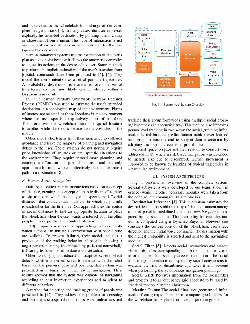
Fig. 1. System Architecture Overview
tracking their group formations using multiple social group-
ing hypotheses in a recursive way. This method also improves
person-level tracking in two ways: the social grouping infor-
mation is fed back to predict human motion over learned
intra-group constraints and to support data association by
adapting track-specific occlusion probabilities.
Personal space, o-space and their relation to comfort were
addressed in [3] where a risk based navigation was extended
to include risk due to discomfort. Human movement is
supposed to be known by learning of typical trajectories in
a particular environment.
III. SYSTEM ARCHITECTURE
Fig. 1 presents an overview of the complete system.
Several subsystems were developed by our team (shown in
orange) while the other necessary modules were taken from
the open source community (white blocks).
Destination Inference [2]: This subsystem estimates the
desired destination within the map of the environment among
a list of possible predefined goals and meeting points com-
puted by the social filter. The probability for each destina-
tion is computed using a Dynamic Bayesian Network that
considers the current position of the wheelchair, user’s face
direction and the initial voice command. The destination with
the highest probability is selected and sent to the navigation
module.
Social Filter [3]: Detects social interactions and creates
virtual obstacles corresponding to those interaction zones
in order to produce socially acceptable motion. The social
filter integrates constraints inspired by social conventions to
evaluate the risk of disturbance and takes it into account
when performing the autonomous navigation planning.
Social Grid: Receives information from the social filter
and projects it to an occupancy grid adequate to be used by
standard motion planning algorithms.
Meeting Points: The social filter uses geometrical infor-
mation from groups of people to compute good places for
the wheelchair to be placed in order to join the group.

Fig. 2. Dynamic Bayesian Network used to estimate the user intendeddestination Dt.
Navigation: The navigation subsystem includes an A*
motion-planner and Dynamic Window controller to compute
safe trajectories to drive the wheelchair.
A. Destination Inference
The user’s intention is modeled as a set of possible
destinations. Those destinations may be defined by the user’s
habits (places where the user spends most of his time during
the day), interesting points taken from the map of the
environment as doors, desks and other facilities and dynamic
destinations related to humans in the scene -For more details
consider reading our previous work [2]. In this work we
propose a method to detect and use destinations defined by
social groups of people.
The presented reasoning method is based on a dynamic
Bayesian network described in Fig. 2.
The joint probability distribution that corresponds to the
graph (Fig. 2) is:
P (D0:t, C0:t, X0:t) = P (X0) P (V0) P (D0|X0, V0)∗∏
k=1:t
[P (Dk|Dk−1)P (Ck|Dk, Xk) P (Xk)] (1)
Where, Xt is the position of the wheelchair in a 2D plane
with respect to the map reference frame. This position is
discrete and its domain is defined by a grid whose size
is according to the map of the environment. It is assumed
that the position of the wheelchair Xt is a fully observable
measurement given by the localization system.
V0 is the starting vocal command. This variable can take
two possible values GO, JOIN. Ct represents the direction
pointed by the user at time t. This direction is centered on
the user’s local frame.
The variable D represents both the static destinations and
the meeting points. The domain of the D variable (denoted
as ΩD) is defined as the union between the set of static
destinations ΩS and the set of meeting points ΩM .
ΩD = ΩS ∨ ΩM (2)
Where, ΩD is the domain of the D variable. Ωs =d(1), d(2), ..., d(N) is the set of N static destinations.
Ωm = d(N+1), d(N+2), ..., d(N+M) is the set of M meet-
ing points.
The inference question to be answer at time t is P (Dt =d(i)|C1:t, X0:t, V0). It can be recursively computed Using
Bayes rule as:
P (D(i)t |C01t, X0:t, V0) = αP (X0:t) P (V0)∗
P (D0|X0, V0) P (Ct|Xt, D(i)t )∗
∑
j
[P (D(i)t |D(j)
t−1)P (D(j)t−1|C1:t−1, X0:t−1, V0)] (3)
The term P (D0|X0, V0) will be referred as the initial
probability model, the term P (Ct|Xt, D(i)t ) is the command
model, P (D(i)t |D(j)
t−1) is the transition model.
The initial probability model has two different modalities,
when V0 = GO the value of this term is encoded in a
probability table [2], whose values are obtained by learning
typical destinations in the environment according to the
user’s habits. However , when V0 = JOIN the meeting
points get an evenly distributed high probability while all
the others get low values.
P (D(i)0 |X0, V0 = GO) = P (D
(i)0 |X0) (4)
P (D(i)0 |X0, V0 = JOIN) =
α/M if d(i) ∈ Ωm
(1− α)/N otherwise(5)
In our tests we used α = 0.9.
P (Ct|Xt, D(i)t ) represents the probability that a command
Ct will be sent by the user when he is located at position
Xt and his destination is d(i) at current time t.
P (Ct|Xt, D(i)t ) =
P ′(Ct|Xt, D(i)t )
∑
i P′(Ct|Xt, D
(i)t )
(6)
where,
P ′(Ct|Xt, D(i)t ) =
1
σ√2π
exp−12 (
ai
σ)2 (7)
The ai term is the angle between the command and the
destination (the value of the standard deviation σ was set
from experimental data to have a value of 0.2).
P (D(i)t |D(j)
t−1) expresses the probability that the current
estimated destination changes respect the last one.
P (D(i)t |D(j)
t−1) =
(gain− 1)/(N + gain− 1) if D(i)t = D
(j)t−1
1/(N + gain− 1) otherwise(8)
Where, N is the number of possible goals in the environ-
ment. gain expresses how important the previous estimation
will be with respect to the new data. Large values of this
term will lead to slow responses whenever the user changes
his intended destination. After practical experimentation it
was defined a value of P (D(i)t |D(j)
t−1) that is 10 times bigger
if the last estimated goal was the same.
The selection of the goal is performed using exact in-
ference. The selected destination is the one with highest
probability.

dsel = argmaxd(i)
P (Dt = d(i)|Ct, Xt) (9)
This goal is then sent to the autonomous navigation system
when the user gives one of the vocal commands ”GO” or
”JOIN”.
B. Social conventions in human navigation
In normal situations, people try to maintain a minimum
space between them to feel comfortable. Hall [9] modeled the
level of discomfort experienced by the person related to the
distance at which he is approached. This idea was formalized
as the concept of personal space, which characterizes the
space around a human being in terms of comfort during
social activities. Similarly, interactions between two or more
people have been modeled using the concept of o-space by
[13].
1) Personal Space: The implemented model consists in
blending two Gaussian functions Γf and Γb (Eq.10) both of
them centered in the position of the person. The first one
represents the personal space in front of a human and is
wider than the last one representing the back space. The
Gaussian values represent the risk of disturbance associated
with a point in the space around the pedestrian.
Γx,Σ(p) = e−12 (p−x)tΣ−1(p−x) (10)
where x, p are in R2 and Σ is a diagonal covariance matrix
defined as:
Σ =
(
σ2x 00 σ2
y
)
. (11)
The appropriate shape of the personal space is obtained
by selecting the same values for σx in both Γf and Γb but
different values for σy , being the one of Γf the double of
the value for Γb.
2) O-Space: When two or more people are in a conversa-
tion, they tend to adopt formations with circular shapes. The
o-space could be taken as a circle whose center coincides
with that of the inner space. For the specific case of two
people, some formations, called F-formations, have been
identified as being particularly frequent [13]. The social filter
identifies individual F-formations (Vis-a-vis or V-Shape) and
builds the corresponding o-space. In Fig. 3, the calculated o-
space for a Vis-a-Vis interaction is shown.
Fig. 3. O-space calculated by the Social Filter Module for a Vis-a-Visformation. The maximum risk of disturbance is located at o-space center, inthe picture the disturbance is represented by the Gaussian function height.
The o-space is represented by a two-dimensional Gaussian
function Γc of covariance matrix S and centered in C, then
for each point Q around the center we have:
ΓC,S(Q) = e−12 (Q−C)tS−1(Q−C) (12)
where S is a diagonal covariance matrix as defined in
Eq.11. To get the shape of the O-space depending on the
formations, some values has been chosen for the parameters
which are shown in the next table:
Formation σx σy
Vis-a-vis DH/3 2 ∗DH/3V-Shape DH/3 2Di
C. Social Cost Grid
Many planning algorithms use occupancy grids as its basic
data structure to represent the state of the world. Practical
implementations of such algorithms typically used in robot
navigation systems (in this work A* and dynamic window)
consider occupancy grids.
In order to adequate the data computed by the social filter
we project the values of the personal space and interaction
space into a 2D occupancy grid. Two different thresholds
are used as shown in Fig. 4. Cells in the occupancy grid
with personal and/or interaction space values higher than
the threshold are marked as occupied zones so the planner
will avoid passing through those regions, while regions with
lower values are marked as free space.
Occupied regions computed in the social grid are then
combined with the occupancy grid created with the robot’s
laser range finder and the map of the environment. In order
to consider the size of the wheelchair the regions marked
as occupied are inflated by an ’inflation radius’ according to
the size of the robotic wheelchair (Fig. 4(b)).
(a) (b)
Fig. 4. Threshold applied to the Gaussian functions delivered by thesocial filter to created the occupancy-cost grid. (b) The inflated area (green)considers the dimensions of the wheelchair. In order to guarantee a pathfree of collisions the center of the wheelchair should never be inside thisarea.
Fig. 5. Projection of both p-space and o-space on the occupancy gridused by the planning algorithm. The Gaussian in the middle represents thevalue of the interaction space, which is projected on the occupancy gridas occupied space (blue area) and then inflated to consider the size of therobot (green area).

D. Computing Meeting Points
A geometrical model is used to determine those places
where the robotic wheelchair should be placed to attract the
attention and become part of an interacting group. Those
points are located in an area, roughly coincident with the o-
space of an interaction where the robot can share the space
in an equitable way with the other humans already present.
Fig. 6 shows different types of social formations and where
the meeting points should be located. Fig. 6(a) represents a
vis-vis or frontal formation where two humans H1 and H2
are talking face to face. In this case two meeting points are
placed on the line perpendicular to the H12 line that joins
H1 and H2. the points are located at a distance DH/2 from
the center of the o-space. DH is the distance between the
two persons.
In the case of a v-shape formation Fig. 6(b) a meeting
point is placed on the line formed by Vi and H12. Vi is the
intersection of the two lines of sight of interacting humans.
The computed meeting points are used by the inference
algorithm as possible destinations as it will be described later.
(a) (b)
Fig. 6. Geometrical placement of meeting points in different socialformations. (a) For a vis-vis formation. (b) For a v-shape formation. Thelocation of Meeting points depends on the focus of attention defined by theorientation of the bodies φ.
(a) (b)
Fig. 7. The resulting meeting points for a vis-vis formation (black markers).If the robot reaches that position, a group of three will be formed. (a) Lateralview. (b) Top view.
IV. SIMULATION EXPERIMENTS
The proposed approach was designed considering the ex-
perimental scenario shown in Fig. 8. People in the scene were
tracked to learn the typical destinations that are then placed
in the map of the environment (red circles in Fig. 8(a)).
Each destination has a related probability value as described
in section III-A. The values for the presented experimental
scenario where presented in a previous publication [2].
The user can start the movement at any location of the
experimental scenario, he drives the wheelchair by seeing
towards his desired destination and saying a vocal command
as JOIN or GO.
(a) (b)
Fig. 8. Possible experimental scenario is located at INRIA main entryhall where typical destinations have been detected in previous works [2].(a) The lines in the figure represent some of the trajectories normallyfollowed by people in the scene. Typical destinations (end of a trajectory)are marked with circles. (b) In the intended application, the position of theuser’s face and the vocal command are used to infer his desired destination.Social formations are detected and the corresponding meeting points (d(10),d(11)) are considered as possible destinations by the destination inferencealgorithm.
A. Face Control Subsystem
The user can control the robotic wheelchair by using the
movements of his face. The direction of the face is estimated
by a random forest classifier which takes as input a 3D point
cloud (for further information on this subject please refer to
[15]).
B. Voice Control Subsystem
As it is impossible to deduce the full range of user
intentions only analyzing the user’s face direction; it is
necessary the system to be multi-modal. For this reason, we
used the Google voice recognition service with a reduced
set of instructions -related to our application- to give those
commands that it would be difficult to express using only
the face as: stop, move, faster, etc.
Some words have an strong context related to the type of
destination that they can be applied to, for example the verb
GO is more general than the verb JOIN which means that it
does not give so much information to infer the user’s desired
destination. However, when the user uses the keyword JOIN,
it is more likely that he intends to approach a group of people
if there is any present on the scene. This behavior is encoded
in the probability distribution of Eq. 5.
C. Multimodal Interface
In the example (Fig. 9), the user is looking in the direction
of the arrow (blue) and there are two people in the middle
of the simulated INRIA-hall. The task of the wheelchair is
to navigate towards the goal that gets the highest posterior
probability.
When the user gives the vocal command to start the
movement (GO or JOIN) the prior probabilities are loaded
and the posterior probability is computed considering the
direction of his face, the probability for each goal is depicted
in Fig. 9 as the size of the sphere. The goal with the
highest posterior probability is sent to the navigation module,
the wheelchair plans the path and compute the necessary

(a) (b)
Fig. 9. In this example we show the different modalities that can beachieved by our method. In the first example (a); given the strong contextrelated to the use of the verb JOIN the probabilities are computed in sucha way that those destinations defined by a group of people get a highervalue. However the use of the verb GO, (b); does not give such contextualinformation; therefore, the destination that gets the maximum probability ismainly defined by the direction in which the user is pointing and the priorprobability model.
(a) (b) (c) (d)
Fig. 10. Error handling. When the system detects an error in the inferreddestination (it is blocked or there is not enough evidence to decide) (a) itasks for help to the user (b). The user gives a new command (c) and if thenew destination is valid it will move towards it.
velocity commands to arrive to the destination while avoiding
obstacles and respecting the personal and interaction spaces.
The destination inference method considers both meeting
points defined by the two persons in vis-vis formation. In
the first case Fig. 9(a): the user gives a JOIN order. Given
the strong context related to this verb the probabilities are
computed in such a way that the meeting points get a higher
probability value than all the other possible destinations.
In the second case Fig 9(b) the user gives a GO order
which does not give as much contextual information as
the JOIN command, so the probability distribution is more
evenly distributed, therefore, the destination that gets the
maximum probability value is mainly defined by the direc-
tion in which the user is looking.
In case of an error, for example when the inferred desti-
nation can not be reached because it is occupied or there is
not enough evidence to decide which destination is better.
The system will ask for help and wait for the user to give a
new command. In the example Fig. 10 the system selects a
meeting point that is not reachable by the wheelchair, then it
asks for help and waits for the user to give a new command.
When the new command is considered a new destination
could be selected and if the new destination is valid the
wheelchair will start moving.
V. CONCLUSIONS AND FUTURE WORK
The approach presented in this paper integrates a human
aware cost grid with an standard autonomous navigation con-
troller. The system was designed to improve both usability
taking advantage of the user intention inference method and
sociability by including the concepts of personal space and
o-space in the navigation system.
The main contributions presented in this article were; first
of all, the method to compute socially accepted points to join
a group of people and then use them as possible destinations
for the user. Second, the use of information from several
user-machine interfaces - voice and face position-, to reduce
ambiguities in the inference model.
REFERENCES
[1] D. Bernardin, H. Kadone, D. Bennequin, T. Sugar, M. Zaoui, andA. Berthoz, “Gaze anticipation during human locomotion.” Experi-
mental brain research, Sept. 2012.[2] J. A. Escobedo Cabello, A. Spalanzani, and C. Laugier, “Multimodal
Control of a Robotic Wheelchair: Using Contextual Information forUsability Improvement,” in IEEE/RSJ International Conference on
Intelligent Robots and Systems, Nov. 2013.[3] J. Rios-Martinez, A. Spalanzani, and C. Laugier, “Understanding
human interaction for probabilistic autonomous navigation using Risk-RRT approach,” in IEEE/RSJ International Conference on Intelligent
Robots and Systems, Sept. 2011, pp. 2014–2019.[4] Y. Wang and W. Chen, “Hybrid map-based navigation for intelligent
wheelchair.” in ICRA. IEEE, 2011, pp. 637–642.[5] E. Demeester, A. Huntemann, D. Vanhooydonck, G. Vanacker,
A. Degeest, H. Brussel, and M. Nuttin, “Bayesian Estimation ofWheelchair Driver Intents: Modeling Intents as Geometric PathsTracked by the Driver,” 2006 IEEE/RSJ International Conference on
Intelligent Robots and Systems, no. Iros, pp. 5775–5780, Oct. 2006.[6] E. Demeester, A. Huntemann, J. del R. Millan, and H. Van Brussel,
“Bayesian plan recognition for Brain-Computer Interfaces,” 2009
IEEE International Conference on Robotics and Automation, pp. 653–658, May 2009.
[7] T. Taha, J. V. Miro, and G. Dissanayake, “POMDP-based long-term user intention prediction for wheelchair navigation,” 2008 IEEE
International Conference on Robotics and Automation, pp. 3920–3925,May 2008.
[8] G. Vanacker, J. del R Millan, E. Lew, P. W. Ferrez, F. G. Moles,J. Philips, H. Van Brussel, and M. Nuttin, “Context-based filteringfor assisted brain-actuated wheelchair driving.” Computational intel-
ligence and neuroscience, vol. 2007, p. 25130, Jan. 2007.[9] E. T. Hall, The hidden Dimension: Man’s Use of Space in Public and
Private. The Bodley Head Ltd, London, UK, 1966.[10] S. Satake, T. Kanda, D. F. Glas, M. Imai, H. Ishiguro,
and N. Hagita, “How to Approach Humans?-Strategies forSocial Robots to Initiate Interaction-,” J. Robot. Soc. Japan,vol. 28, no. 3, pp. 327–337, 2010. [Online]. Available:http://joi.jlc.jst.go.jp/JST.JSTAGE/jrsj/28.327?from=CrossRef
[11] S. T. Hansen, M. Svenstrup, H. J. Andersen, and T. Bak, “Adaptivehuman aware navigation based on motion pattern analysis,” The 18th
IEEE International Symposium on Robot and Human Interactive
Communication, 2009.[12] M. Luber and K. O. Arras, “Multi-Hypothesis Social Grouping and
Tracking for Mobile Robots,” in Robot. Sci. Syst., 2013.[13] A. Kendon, “Spacing and orientation in co-present interaction,” in De-
velopment of Multimodal Interfaces: Active Listening and Synchrony,ser. Lecture Notes in Computer Science. Springer Berlin / Heidelberg,2010, vol. 5967, pp. 1–15.
[14] J. Rios-Martinez, “Navigation de robots avec conscience social:entre l’evaluation des risques et celle des conventions sociales,”THESE, Universite de Grenoble, Jan. 2013. [Online]. Available:http://hal.inria.fr/tel-00837525
[15] G. Fanelli, J. Gall, and L. Van Gool, “Real time head pose estima-tion with random regression forests,” Computer Vision and Pattern
Recognition, 2011.