using spatial information to support decisions on safeguards and … · 2014-03-12 · using...
TRANSCRIPT
Using spatial information to support decisions on safeguards and multiple benefits for REDD+ in Tanzania
UN-REDD P R O G R A M M E
UNEPEmpowered lives.Resilient nations.
Ministry of Natural Resources & TourismUnited Republic of Tanzania
REDD+ has the potential to contribute to achieving more policy goals than climate mitigation alone. In Tanzania, REDD+ is expected to deliver multiple benefits, whose nature and extent will depend on the location and type of REDD+ activity implemented. These benefits include sustainable use of forest resources, biodiversity conservation, poverty alleviation, maintenance of forest dependent communities’ rights, and improved community livelihoods. The REDD+ safeguards agreed under the United Nations Framework Convention on Climate Change are intended to guide REDD+ implementation to avoid adverse effects to people and the environment, and to ensure multiple benefits.
During the last years, the Tanzanian Forest Service has produced a unique set of forest, socioeconomic and governance related data and maps from 32 000 field inventory plots and interviews with 3500 households and 1100 key informants, which among other sources of data have been used for the production of analysis and maps in this publication.
Maps can help to increase understanding of the spatial distribution of such potential benefits, and support decision-making on where and how REDD+ might be implemented. The maps presented in this brochure were developed to support Tanzania’s implementation of the REDD+ safeguards, and planning for multiple benefits from REDD+. Themes include natural forest, biodiversity, ecosystem services, drivers of deforestation and forest degradation, and potential zones for implementation of REDD+ activities.
Contact:Ministry of Natural Resources & TourismTanzania Forest Services, P.O. Box 40832,Dar es Salaam, United Republic of TanzaniaEmail: [email protected] ; [email protected]: http://www.tanzania.go.tz/natural.htm
UN-REDD P R O G R A M M E
UNEPEmpowered lives.Resilient nations.
Ministry of Natural Resources & TourismUnited Republic of Tanzania
I3543E/1/12.13
ISBN 978-92-5-108089-4
9 7 8 9 2 5 1 0 8 0 8 9 4

Vision of Tanzania Forest Service: A center of excellence in the conservation of forest and bee resources and sustainable supply of quality forest and bee products and services in Tanzania. Mission of Tanzania Forest Service: To sustainably manage the national forest and bee resources in order to contribute to the social, economic, ecological and cultural needs of the present and future generations.
The UN-REDD Programme is the United Nations collaborative initiative on Reducing Emissions from Deforestation and forest Degradation (REDD+) in developing countries. The Programme was launched in 2008 and builds on the convening role and technical expertise of the Food and Agriculture Organization of the United Nations (FAO), the United Nations Development Programme (UNDP) and the United Nations Environment Programme (UNEP). The UN-REDD Programme supports nationally-led REDD+ processes and promotes the informed and meaningful involvement of all stakeholders, including Indigenous Peoples and other forest-dependent communities, in national and international REDD+ implementation.
The United Nations Environment Programme World Conservation Monitoring Centre (UNEP-WCMC) is the specialist biodiversity assessment centre of the United Nations Environment Programme (UNEP), the world’s foremost intergovernmental environmental organisation. The Centre has been in operation for over 30 years, combining scientific research with practical policy advice.
DISCLAIMERThe designations employed and the presentation of material in this information product do not imply the expression of any opinion whatsoeveron the part of MNRT, UNEP-WCMC, or FAO concerning the legal or development status of any country, territory, city or area or of its authorities, or concerning the delimitation of its frontiers or boundaries. The mention of specific companies or products of manufacturers, whether or not these have been patented, does not imply that these have been endorsed or recommended by MNRT, UNEP-WCMC or FAO in preference to others of a similar nature that are not mentioned. The views expressed in this information product are those of the author(s) and do not necessarily reflect the views or policies of MNRT, UNEP-WCMC or FAO.
FAO encourages the use, reproduction and dissemination of material in this information product. Except where otherwise indicated, material may be copied, downloaded and printed for private study, research and teaching purposes, or for use in non-commercial products or services, provided that appropriate acknowledgement of FAO as the source and copyright holder is given and that FAO’s endorsement of users’ views, products or services is not implied in any way. All requests for translation and adaptation rights, and for resale and other commercial use rights should be made via www.fao.org/contact-us/licencerequest or addressed to [email protected].
FAO information products are available on the FAO website (www.fao.org/publications) and can be purchased through [email protected].
© FAO, 2013
ACKNOWLEDGEMENTSThis report is a joint publication between the Ministry of Natural Resources & Tourism and the UN-REDD Programme, supported by FAO (FAO-Finland Forestry Programme and FAO/UN-REDD HQ team) and UNEP-WCMC. The production of this report has been funded by Tanzania’s UN-REDD National Programme, with additional technical support under the UN-REDD Global Programme.
This report contributes towards Output 2.4 in Tanzania’s National REDD+ Programme: “develop national maps to inform the delivery of the REDD+ framework”. We would like to thank all those who provided technical input and/or feedback on the draft, including: Nuru Chamuya, Evarist Nashanda, Soren Dalsgaard, Neil Burgess, Roy Gereau, Gino Miceli, Cosimo Togna, Christine Holding, Lauri Tamminen, Ralf Ernst, Philip Platts, Robert Marchant, Han Meng, Megan Albon, Kekilia Namala, Rahima Njaidi, Clara Makenya, Antonia Ortmann, Wilbert Karugaba and Amana Seleman.
UN-REDD P R O G R A M M E
UNEPEmpowered lives.Resilient nations.
Ministry of Natural Resources & Tourism (MNRT)Tanzania Forest Service, P.O. Box 40832, Dar es Salaam, United Republic of TanzaniaEmail: [email protected]: http://www.mnrt.go.tz/index.php/about-us/contact-us
Available online at: http://www.un-redd.org/tabid/5954/Default.aspx Photos: Front and back cover: © Corinna Ravilious
Almas KashindyeFAO UN-REDD Programme, P.O Box 2, Dar es Salaam, United Republic of [email protected]
Richard GilibaForestry Training Institute, Olmotonyi, P.O Box 943, Arusha, United Republic of TanzaniaEmail: [email protected]
Veronica Hailakwahi, Shani Khalid, Yohane MwampashiFO-Mapping Unit, Ministry of Natural Resources & Tourism, Tanzania Forest Services, P.O. Box 40832, Dar es Salaam, United Republic of TanzaniaE-mail: [email protected], [email protected], [email protected]
Boniface Mbilinyi, Msalika Pastory, Ludovic RA KashagaSokoine University of Agriculture, P.O. Box 3000, Chuo Kikuu, Morogoro, United Republic of Tanzania E-mail: [email protected], [email protected], [email protected]
Lisen Runsten, Corinna Ravilious, Rebecca Mant, Matea Osti, Lera Miles UNEP World Conservation Monitoring Centre, 219 Huntingdon Road, Cambridge, CB3 0DL, UKE-mail: [email protected]
Philippe Crête, Anssi Pekkarinen, Mikko Leppanen FAO-Finland Forestry Programme and UN-REDD Programme Food and Agriculture Organization of the United Nations Viale delle Terme di Caracalla, 00153 Rome, Italy Email:[email protected], [email protected], mikko.lep-
CITATION Runsten, L., Ravilious, C., Kashindye, A., Giliba, R., Hailakwahi, V., Kashaga, L.R.A., Khalid, S., Mbilinyi, B., Mwampashi, Y., Pastory, M., Mant, R., Osti, M., Crête, P., Pekkarinen, A., Leppanen, M., Miles, L. (2013) Using spatial information to support decisions on safeguards and multiple benefits for REDD+ in Tanzania. Prepared by UNEP-WCMC, Cambridge, UK; published by Ministry of Natural Resources & Tourism, Dar es Salaam, United Republic of Tanzania.
CONTRIBUTORS

Using spatial information to support decisions on safeguards and multiple benefits for REDD+ in Tanzania
Lisen Runsten, Corinna Ravilious, Almas Kashindye, Richard Giliba, Veronica Hailakwahi, Ludovic R.A. Kashaga, Shani Khalid, Boniface Mbilinyi, Yohane Mwampashi, Msalika Pastory, Rebecca Mant, Matea Osti, Philippe Crête, Anssi Pekkarinen, Mikko Leppanen and Lera Miles
Contents1. Introduction.............................................................................................................................................1 1.1 Forests in Tanzania ............................................................................................................................2 1.2 REDD+ implementation and safeguards in Tanzania ........................................................................42. Planning for REDD+ multiple benefits and safeguards ............................................................................5 2.1 Biomass carbon stocks of Tanzania ...................................................................................................5 2.2 Natural forest ....................................................................................................................................6 2.3 Biodiversity .....................................................................................................................................12 2.4 Ecosystem services .........................................................................................................................18 2.4.1 Non-timber forest products ...................................................................................................18 2.4.2 Soil erosion .............................................................................................................................20 2.5 Land designations ...........................................................................................................................22 2.5.1 Land-use planning ..................................................................................................................22 2.5.2 Petroleum exploration ...........................................................................................................22 2.6 Pressures on biodiversity, carbon and other ecosystem services ..................................................25 2.6.1 Population density in relation to forests and carbon stocks ..................................................25 2.6.2 Road network and link to charcoal production ......................................................................25 2.6.3 Fire ..........................................................................................................................................293. Potential zones for implementing different REDD+ activities - some examples ...................................304. Conclusions and outlook .......................................................................................................................40Annex I.......................................................................................................................................................42References .................................................................................................................................................44
Maps:
1. NAFORMA land-use land-cover (LULUC) map for Tanzania ..................................................................32. Woody biomass carbon compared with above-ground biomass carbon (three different datasets) ....73. Soil organic carbon ...............................................................................................................................84. Combined carbon map .........................................................................................................................85. Natural forest estimations based on the NAFORMA land-use land-cover map .................................106. Average tree species richness in NAFORMA plots ..............................................................................137. Observed threatened tree species in the NAFORMA inventory .........................................................148. Animal species (mammals, birds, amphibians) richness in relation to above-ground woody biomass
carbon .................................................................................................................................................159. Animal species (mammals, birds, amphibians) richness in relation to above-ground woody biomass
carbon .................................................................................................................................................1610. Important wildlife corridors in relation to protected areas, natural forest and woody biomass carbon
stocks ..................................................................................................................................................1711. Non-timber forest products observed in the plots of the NAFORMA biophysical survey ..................1912. Importance of forests for limiting soil erosion ...................................................................................2113. Land-use designations: reserved land by the Tanzanian government (forest reserves and other
protected areas) and location of PFM (CBFM and JFM) activities ......................................................2314. Woody biomass carbon stocks, natural forest and protected areas ..................................................2415. Current petroleum exploration licences, applications and open acreage ..........................................2516. Population and woody biomass carbon density .................................................................................2717. Change in population density in Tanzania between 2002 and 2012 (increase in persons per square
kilometre)............................................................................................................................................2718. Plots where the NAFORMA field inventory has observed impact on the land from charcoal
production ..........................................................................................................................................2819. Areas exposed to fire in Tanzania, shown together with natural forest and protected areas, including
forest reserves with protection status ...............................................................................................2920. Potential zones for REDD+ actions to maintain existing forest and avoid forest degradation ...........3321. Potential zones for REDD+ actions to extend areas of community based forest management
(CBFM) to enhance sustainable management of forests ....................................................................3522. Potential zones for REDD+ action to enhance sustainable management of forest in production forest
reserves ..............................................................................................................................................3723. Potential zones for REDD+ action to rehabilitate forests....................................................................39

United Republic of Tanzania 1
1. Introduction An estimated 6-17% per cent of all anthropogenic greenhouse gas (GHG) emissions are caused by deforestation and forest degradation, including peatland emissions (van der Werf et al. 2009). The maintenance and careful management of forest carbon stocks can therefore make an important contribution to global climate change mitigation. However, pressure to convert and degrade forests continues to be high, particularly in forest-rich developing nations. Countries through the United Nations Framework Convention on Climate Change (UNFCCC) are preparing to address this issue through REDD+: a climate change mitigation mechanism aiming to significantly reduce emissions from deforestation and forest degradation, and increase removals of carbon dioxide, whilst promoting the sustainable development of the nations involved. REDD+ actions fall under five main activities (see Figure 1).
REDD+ has the potential to contribute to achieving more policy goals than climate mitigation alone. By maintaining and restoring forests, REDD+ could secure the many ecological functions of forests, including biodiversity conservation and the provisioning of a number of ecosystem services that people depend upon, such as water regulation, erosion control and the supply of timber and non-timber forest products. Direct social benefits from national REDD+ implementation are also anticipated, ranging from improved forest governance to direct financial improvements to livelihoods.
The Government of Tanzania expects to attain a range of multiple benefits from implementing its
REDD+ strategy. To achieve this, the country could develop and employ a suite of approaches to REDD+ implementation to account for the variation in environmental, social and cultural factors in different locations. As stated by the country’s REDD+ Strategy:
“A properly designed [REDD+] implementation mechanism is expected to contribute to multiple benefits, depending on the location and type of REDD+ activity. These benefits include poverty alleviation, maintenance of forest dependent communities’ rights, improved community livelihoods, technology transfer, sustainable use of forest resources and biodiversity conservation.” Source: Tanzania Vice President’s Office (2013a)
This report presents spatial analyses developed during two working sessions in 2013 with members of the Tanzania Forest Service, Sokoine University of Agriculture, Forestry Training Institute (FTI) Olmotonyi
REDD+
Reducing emissions from Deforestation and forest Degradation
+Conservation of forest carbon stocksSustainable management of forestsEnhancement of forest carbon stocks
=
Figure 1: REDD+ activities
1© Corinna Ravilious

Using spatial information to support decisions on safeguards and multiple benefits for REDD+2
and the UN-REDD Programme. The maps developed aim to support assessments of the potential for multiple benefits of REDD+ implementation at the national scale in Tanzania, and contribute to REDD+ plans, taking REDD+ safeguards into account. The maps also contribute towards the action in the Tanzania REDD+ Action Plan, which states that the country will: “(1.3) Develop integrated methods to quantify REDD+ and other forest benefits such as biodiversity, ecotourism, and water catchment related to PES [(Payments for Ecosystem Services)]”, with a specific activity to “Develop a package of integrated methods for REDD+ co-benefits mapping” (Tanzania Vice President’s Office 2013b).
It should be noted that the maps were developed using the best available data at the time, and can be updated when better data become available. To support decision making, the maps will need to be complemented with additional information for each REDD+ action that is being considered, including local data and knowledge. For a more detailed account of the mapping methodology used in this report, please refer to the Tanzania Methodological Brief, available at:http://www.un-redd.org/tabid/1028/Default.aspx.
1.1 Forests in Tanzania The United Republic of Tanzania is the largest country in East Africa, with a mainland area of 946 270 km2, and 2 470 km2 on the islands of Zanzibar (Unguja and Pemba). In 2012, the country had a population of 44.9 million people (Tanzania National Bureau of Statistics 2013). The country’s forest ecosystems include humid and evergreen montane and lowland forests, seasonal and semi-evergreen coastal forests and thickets, strongly seasonal and deciduous miombo woodlands, Acacia-Commiphora woodlands and mangroves. These forests provide a range of different goods and services for people, many of whom are forest dependent (Blomley & Iddi 2009). For example, goods include timber and non-timber forest products (NTFPs) such as medicinal plants, and services include water and climate regulation. The forests in Tanzania are also high in biodiversity: aside from a rich fauna, the country contains over 10 000 plant species, hundreds of which are nationally endemic. Of the plant and animal species in Tanzania, 724 species are identified as Threatened in the IUCN Red List, with 276 species classified as Endangered (IUCN 2013).
In 2013, Tanzania, with financial support of the Government of Finland and technical support of the FAO-Finland Forestry Programme, completed its first comprehensive forest inventory – “NAFORMA”.
It is one of the biggest efforts made to date by a developing country to map its forest resources, and one of the purposes was to help the country meet its requirements under REDD+. The NAFORMA inventory comprised 32 660 ground plots organized in 3 419 clusters, and over 240 000 trees were measured (Ministry of Natural Resources & Tourism 2010; NAFORMA 2013). The biophysical assessment covered not only tree parameters, but also the state of the land and notable features at the plot location, such as land use, vegetation type, soil, shrubs, regeneration, forest management, disturbances, dead wood, stumps, bamboos and forests products and services (Ministry of Natural Resources & Tourism 2010). A new comprehensive land-use land-cover map was also developed from Landsat imagery to be accurate for the year 2010. For this map, vegetation classes were mainly adopted from the Hunting Technical Services (1995) map for the country, with a few modifications to reflect ground conditions (Map 1).
The biophysical assessment in NAFORMA was complemented by a socioeconomic survey, aiming to collect data on land uses from the local users, to support national decision making on improved land- use policies that takes into account people’s reality and needs. Socioeconomic data was collected from 3 500 household and 1 100 key informant interviews. In total, over 200 parameters1 were recorded in the interviews.
The first analysis of the NAFORMA field inventory by FAO estimates 51 per cent of Tanzania’s land area to be woodland and 4 per cent to be forest, including humid montane and lowland forest, and mangroves.
1 Parameters recorded included: household income sources; food security including use of wild food plants; harvesting of forest products including charcoal, fuelwood and honey by zone and region; household perception of user rights and local rules with regard to the harvesting of forest products; household energy; awareness and participation of key informants and household respondents in PFM; forest disturbance and governance.
© Corinna Ravilious

United Republic of Tanzania 3
The mean density of growing stock in Tanzania is low, on average 34 m3/ha for all land covers. NAFORMA plots show higher woody volumes in remote areas due to inaccessibility and thereby document a substantial human impact. Forest in protected areas, where harvesting is not allowed, holds about half of the woody biomass volume in the country.
The main direct causes of uncontrolled deforestation and forest degradation in Tanzania’s forests include: small-scale agricultural expansion, human
settlements and population increase, firewood and charcoal production, uncontrolled fires (especially June - October), timber extraction, overgrazing, development of infrastructure, industry and mining, and introduction of large-scale agriculture. Together, these drivers contribute towards an annual deforestation rate of between 130 000 and 500 000 ha per annum (FAO 2010).

Using spatial information to support decisions on safeguards and multiple benefits for REDD+4
1.2 REDD+ implementation and safeguards in Tanzania In 2008, Tanzania received bilateral financial support from Norway to start the Tanzania REDD+ Initiative. In addition, multilateral support from the UN-REDD Programme enabled the launch of Tanzania’s UN-REDD National Programme in 2009, now scheduled to conclude in 2013.
In March 2013, the Government endorsed the National REDD+ Strategy and its Action Plan. It is anticipated that there will be changes to legal frameworks that regulate incentives, rights, financing options and practices as a result of REDD+. The REDD+ Strategy recognizes that this does not automatically ensure that there will be no negative impacts on the environment or livelihoods and the rights of communities (Tanzania Vice President’s Office 2013a), and affirms that the implementation of REDD+ activities will be done in accordance with the Cancun REDD+ Safeguards2.
The REDD+ Strategy also states that a system for providing information on safeguards is to be developed that is consistent with the Cancun
Safeguards, and in line with World Bank policies on Environmental Assessment, Natural Habitats, Forests, Involuntary Resettlement, and Indigenous Peoples. The Strategy further states “this system will require spatial monitoring information that is: (...) consistent with the conservation of natural forests and biological diversity” (Tanzania Vice President’s Office 2013a). The Measuring, Reporting and Verification (MRV) System is to be integrated with the REDD+ Safeguards Information System.
At the time of writing, Tanzania has a draft REDD+ Safeguards document (dated June 2013), which constitutes the national interpretation of the Cancun Safeguards in accordance with the country’s REDD+ Strategy. The draft may still change substantially, as it is being subjected to several stakeholder consultations and drafting rounds during 2013.
On environmental aspects, the draft REDD+ Safeguards document states that the REDD+ Programme will maintain and enhance conservation of Tanzania’s biodiversity and other ecosystem services, considering the needs of forest dependent communities and appropriate management and utilization methods (see Table 1). It specifies that REDD+ activities are to be designed to maintain and enhance biodiversity and
Table 1: Excerpt from the June 2013 version of the draft Tanzania REDD+ Safeguards: Principle 7 (Tanzania Vice President’s Office 2013c). Other parts of the document are also relevant to the topics covered in this publication, but key text for biodiversity and ecosys-tem services are included under Principle 7.
Principle 7: REDD+ Programme maintains, promotes and enhances the conservation of the country’s natural forests for their biodiversity and other ecosystem services (co-benefits) while meeting the needs of forest dependent communities.
Criteria Indicators
7.1 The REDD+ initiative analyses the possible impacts on biodiversity and other ecosystem services when considering options for REDD+ actions
7.1.1 The national MRV system incorporate the assessment of biodiversity and other ecosystem services
7.1.2 Positive and negative impacts of REDD+ on Biodiversity and other ecosystem services identified and analyzed in a transparent and participatory way using available scientific methods
7.1.3 Scientifically sound assessment frameworks for analyzing impacts of REDD+ on biodiversity and other ecosystems services are in place and utilized
7.1.4 Mechanisms to address negative and promote positive impacts of biodiversity and ecosystems services as a result of REDD+ programme in place and implemented
7.2 REDD+ initiative maintains and enhances the conservation of biodiversity and other ecosystem services and considering the needs of forest dependent communities and appropriate management and utilization methods.
7.2.1 Additional resources to maintain and enhance biodiversity and other ecosystem services are generated by the REDD+ initiative
7.2.2 Species or ecosystems that are rare, endemic or threatened with extinction are identified, protected and monitored.
7.2.3 REDD+ activities are designed to maintain and enhance biodiversity, ecosystem services and forest dependent community needs
7.2.4 Monitoring plan for the impacts/outcomes of REDD+ activities on biodiversity and ecosystems is developed and implemented
7.2.5 Biodiversity and other ecosystem services research and information dissemination plan developed and implemented to improve biodiversity conservation and management
7.2.6 Biodiversity and other ecosystem services conservation and management guidelines developed and incorporated in forest management plans in REDD+ sites
7.3 The REDD+ programme protects natural forests from degradation and conversion to other land uses including forest plantations
7.3.1 REDD+ actions that protect natural forests from conversion are identified, prioritized and implemented
7.3.2 Monitoring of impacts of REDD+ actions on natural forests is done in a transparent and participatory way
7.3.3 REDD+ activities are designed to maintain and enhance protection of natural forests
7.4 The REDD+ Programme ensures restoration of degraded areas using indigenous species.
7.4.1 The REDD+ activities promotes and uses indigenous species to restore degraded areas
7.4.2 Mechanisms to monitor the use of indigenous species in the restoration of degraded areas are in place and utilized
2 Annex 1 of UNFCCC Decision 1/CP.16
United Republic of Tanzania 5
ecosystem services, and that species or ecosystems that are rare, endemic or threatened with extinction should be identified, protected and monitored. It implies that the REDD+ Programme will protect natural forests from degradation and conversion to other land uses, including to forest plantations, and that it shall also promote and use indigenous species to restore degraded areas. Furthermore, it states that the REDD+ Programme shall analyse the possible impacts on biodiversity and other ecosystem services when considering options for REDD+ actions.
2. Planning for REDD+ multiple benefits and safeguards
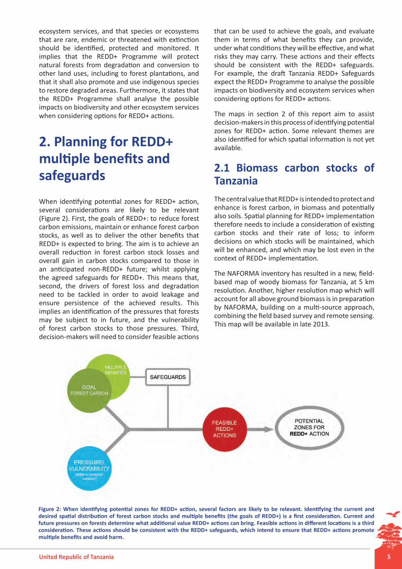
When identifying potential zones for REDD+ action, several considerations are likely to be relevant (Figure 2). First, the goals of REDD+: to reduce forest carbon emissions, maintain or enhance forest carbon stocks, as well as to deliver the other benefits that REDD+ is expected to bring. The aim is to achieve an overall reduction in forest carbon stock losses and overall gain in carbon stocks compared to those in an anticipated non-REDD+ future; whilst applying the agreed safeguards for REDD+. This means that, second, the drivers of forest loss and degradation need to be tackled in order to avoid leakage and ensure persistence of the achieved results. This implies an identification of the pressures that forests may be subject to in future, and the vulnerability of forest carbon stocks to those pressures. Third, decision-makers will need to consider feasible actions
that can be used to achieve the goals, and evaluate them in terms of what benefits they can provide, under what conditions they will be effective, and what risks they may carry. These actions and their effects should be consistent with the REDD+ safeguards. For example, the draft Tanzania REDD+ Safeguards expect the REDD+ Programme to analyse the possible impacts on biodiversity and ecosystem services when considering options for REDD+ actions.
The maps in section 2 of this report aim to assist decision-makers in this process of identifying potential zones for REDD+ action. Some relevant themes are also identified for which spatial information is not yet available.
2.1 Biomass carbon stocks of Tanzania The central value that REDD+ is intended to protect and enhance is forest carbon, in biomass and potentially also soils. Spatial planning for REDD+ implementation therefore needs to include a consideration of existing carbon stocks and their rate of loss; to inform decisions on which stocks will be maintained, which will be enhanced, and which may be lost even in the context of REDD+ implementation.
The NAFORMA inventory has resulted in a new, field-based map of woody biomass for Tanzania, at 5 km resolution. Another, higher resolution map which will account for all above ground biomass is in preparation by NAFORMA, building on a multi-source approach, combining the field based survey and remote sensing. This map will be available in late 2013.
Figure 2: When identifying potential zones for REDD+ action, several factors are likely to be relevant. Identifying the current and desired spatial distribution of forest carbon stocks and multiple benefits (the goals of REDD+) is a first consideration. Current and future pressures on forests determine what additional value REDD+ actions can bring. Feasible actions in different locations is a third consideration. These actions should be consistent with the REDD+ safeguards, which intend to ensure that REDD+ actions promote multiple benefits and avoid harm.