utah geological surveyfiles.geology.utah.gov/online/techrpt/kanabcreek0305.pdfutah geological survey...
TRANSCRIPT

Utah Geological Survey Project: March 12, 2005, fatal earth-fall landslide along Kanab Creek, Kane County, Utah By: William R. Lund, P.G.
Date: 03-06-05
County: Kane
USGS Quadrangles: Kanab (29)
Section/Township/Range: NW¼NW¼ section 33, T. 43 S., R. 6 W., SLB&M
Requested by: Fatality Investigation
Job number: 05-02
INTRODUCTION
At about 5:30 p.m. on Saturday, March 12, 2005, a vertical arroyo (gully with steep walls in unconsolidated sediment) wall along Kanab Creek (figure 1) failed and buried a 10-year-old boy and partially buried two girls. The girls, one covered by landslide material to her waist and the other to her knees, were able to free themselves and began searching for the boy, but were forced to flee when a second section of the wall collapsed. The landslide involved about a 100-foot-long section of the approximately 60-foot-high vertical west bank of Kanab Creek within the city limits of Kanab, Utah (figure 2). Workers using heavy equipment required 15 hours to recover the boy’s body.
Because of the resultant death, the Utah Geological Survey (UGS) made an investigation to determine the characteristics of the fatal landslide and the likelihood of similar slope failures in the future. The scope of the investigation included a review of applicable geologic literature, examination of 1:40,000-scale stereoscopic aerial photographs, and a
e
Figure 1. This approximately 6on March 12, 2005, creating anburied one child and partially blayers of sand, silty sand, and siof the stream cut.
1
meter scal
0-foot-high arroyo wall failed earth-fall landslide that uried two others. Alternating lty clay comprise the majority

Figure 2. Ortho-photograph map of the Kanab area showing landslide site.
2

field reconnaissance of the landslide site on Tuesday, March 15, 2005. The field reconnaissance included an interview with Kanab City Police Chief Tom Cram, who directed the rescue and recovery efforts. Because of continued slope instability during the field reconnaissance, direct access to the arroyo wall where the landslide occurred was not safe.
CONCLUSIONS AND RECOMMENDATIONS
The slope failure that buried the young boy and his companions was an earth-fall-type landslide (Cruden and Varnes, 1996), which resulted from the long-term effect of gravity on over-steepened, unconsolidated material in the arroyo walls. A section of the wall detached along one or more wall-parallel cracks and fell to the stream bottom below where the children were playing. Although the upper few feet of material in the wall were moist as a result of greater than normal precipitation over the past several months, the bulk of the landslide material was dry at the time of failure. Inspection of vertical arroyo walls both up- and downstream from the landslide showed that wall-parallel cracks also are present in those areas, and likely are common elsewhere along Kanab Creek.
The presence of wall-parallel cracks along Kanab Creek where landslides have not yet
occurred, and the fact that the earth-fall landslide took place under what were essentially dry conditions, indicates that similar landslides may occur along Kanab Creek at any time in the future. Increased precipitation over the past several months does not appear to have been a major contributing factor to the landslide, further indicating that similar failures may occur regardless of precipitation conditions.
Measures that may help reduce future injury or loss of life from similar landslides along
Kanab Creek include:
• Identifying areas of Kanab Creek bordered by vertical arroyo walls and posting them as hazardous.
• Grading vertical arroyo walls back to a safe slope angle. • Implementing a hazards-education program in local schools to educate children and
parents regarding landslide hazards along Kanab Creek and the dangers they pose.
GEOLOGIC SETTING
Kanab Creek is a typical semi-arid southwestern U.S. arroyo (figure 3), which deeply
incised its channel during a series of floods beginning in the early 1880s (Webb and others, 1991). Prior to that time, the creek was described as a “shallow braided stream” that meandered across a broad, nearly flat meadow formed where the stream exited the Vermillion Cliffs to the north. Currently the high arroyo walls of Kanab Creek range from vertical where the stream is close to the base of the wall and erosion is active, to near the angle of repose for sandy material (about 40o or less) where the stream is more distant and colluvium has accumulated at the base of
3

the wall. Cottonwood and willow trees line the sides of the active stream channel, and sagebrush and grasses grow on the arroyo walls where slopes permit.
Figure 3. View to the southwest of Kanab Creek, showing the steep-walled arroyo that formed due to floods in the 1880s.
Although flowing within a few tens of feet of the arroyo wall at the time of the landslide,
Kanab Creek was not actively eroding the base of the wall prior to the landslide. To facilitate rescue and recovery operations, workers used heavy equipment to divert Kanab Creek away from the west side of the arroyo, confining it to an artificial channel around the landslide site, where it remained at the time of the field reconnaissance. The workers also used the heavy equipment to move much of the landslide debris during the rescue and recovery operation, so that documentation of the amount and distribution of material generated by the landslide was not possible. However, according to Tom Cram (Kanab City Police Chief, verbal communication, 2005), the landslide resulted in a pile of material at the base of the arroyo wall as much as 20 feet thick and several tens of feet wide.
Geologic materials exposed in the arroyo wall where the landslide occurred consist
chiefly of alternating layers of medium- to thick-bedded (6 inches to 2 feet) red sand, silty sand, and silty clay with discontinuous, thin interbeds of well-sorted white sand, gray clay, and gravel and cobbles (figure 1; appendix). These materials were deposited by Kanab Creek, and were derived chiefly from Mesozoic sedimentary rocks (sandstone, siltstone, and claystone) that crop out in the Kanab Creek drainage basin (Sargent and Philpott, 1987). A few feet of loose, wind-blown sand caps the cut.
4
LANDSLIDE FAILURE MECHANISM
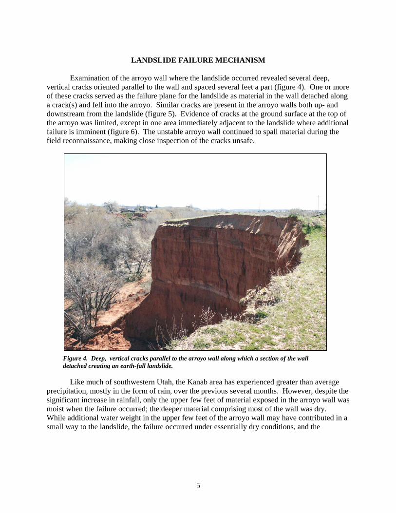
Examination of the arroyo wall where the landslide occurred revealed several deep,
vertical cracks oriented parallel to the wall and spaced several feet a part (figure 4). One or more of these cracks served as the failure plane for the landslide as material in the wall detached along a crack(s) and fell into the arroyo. Similar cracks are present in the arroyo walls both up- and downstream from the landslide (figure 5). Evidence of cracks at the ground surface at the top of the arroyo was limited, except in one area immediately adjacent to the landslide where additional failure is imminent (figure 6). The unstable arroyo wall continued to spall material during the field reconnaissance, making close inspection of the cracks unsafe.
Figure 4. Deep, vertical cracks parallel to the arroyo wall along which a section of the wall detached creating an earth-fall landslide.
Like much of southwestern Utah, the Kanab area has experienced greater than average precipitation, mostly in the form of rain, over the previous several months. However, despite the significant increase in rainfall, only the upper few feet of material exposed in the arroyo wall was moist when the failure occurred; the deeper material comprising most of the wall was dry. While additional water weight in the upper few feet of the arroyo wall may have contributed in a small way to the landslide, the failure occurred under essentially dry conditions, and the
5

landslide most likely resulted from the long-term effect of gravity acting on the over-steepened unconsolidated material in the wall.
FUTURE HAZARD POTENTIAL
The presence of
additional wall-parallel cracks where arroyo walls along Kanab Creek are vertical and the fact that the earth-fall landslide that killed the young boy took place under essentially dry conditions indicates that similar slope failures may occur along Kanab Creek at anytime in the future and are largely independent of precipitation conditions.
LIMITATIONS
Figure 5. Vertical cracks parallel to the arroyo wall in an area adjacent to the landslide that has not yet failed; such cracks are typical where arroyo walls are vertical.
Although this product represents the work of professional scientists, the Utah Department of Natural Resources, Utah Geological Survey, makes no warranty, express or implied, regarding its suitability for a particular use. The Utah Department of Natural Resources, Utah Geological Survey, shall not be liable under any circumstances for any direct, indirect, special, incidental, or consequential damages with respect to claims by users of this product.
REFERENCES American Society for Testing and Materials (ASTM), 1984, Standard practice for description
and identification of soils (visual – manual procedure) – Designation D 2488-84: Annual Book of ASTM Standards, v. 04.08, p. 409-423.
6

Figure 6. Partially detached section of the arroyo wall where additional failure is imminent. Cruden, D.M., and Varnes, D.J., 1996, Landslide types and processes, in Turner, K.A., and
Schuster, R.L., editors, Landslides, investigation and mitigation: Washington, D.C., National Academy Press, National Research Council Transportation Research Board Special Report 247, p. 36-75.
Sargent, K.A., and Philpott, B.C., 1987, Geologic map of the Kanab quadrangle, Kane County, Utah and Mohave and Coconino Counties, Arizona: U.S. Geological Survey Geologic Quadrangle Map GQ-1603, scale 1:62,500.
Webb, R.H., Smith, S.S., and McCord, V.A.S., 1991, Historic channel change of Kanab Creek – southern Utah and northern Arizona: Grand Canyon Natural History Association Monograph Number 9, 91 p.
APPENDIX
Description of Soil Units Involved in the Landslide
Due to continued instability of the arroyo wall at the time of the field reconnaissance, access to the materials involved in the landslide was limited. The following soil descriptions are
7

based on field soil classification procedures (ASTM, 1984) of materials available at the base of the arroyo wall. Unit thicknesses are estimates.
Top of Arroyo Wall Unit Estimated Thickness Description (feet) 7 3 Sand (SP), light brown (7.5 YR 6/4), loose, moist, well-
sorted, well-rounded, medium quartz sand; slight reaction to HCl, non-cemented; eolian dune sand.
6 5 Interbedded thin (0.5-2 inches) layers of clay and sand, no direct access to this unit, appears similar to unit 1 below.
5 14 Interbedded medium to thick (6 inches to 2 feet) layers of
silty sand and silty clay, no direct access to this unit, appears similar to unit 3 below.
4 2 Silty clay (CL?), light gray (~7.5 YR 8/1), no direct access
to this unit, properties are estimated. 3 24 Interbedded medium to thick layers of (1) silty sand (SM),
red (2.5 YR 4/6), 20% silt, 80% moderately indurated, dry, well-sorted, well-rounded, fine quartz sand; moderate reaction to HCl, slightly cemented, and (2) silty clay (CL), red (2.5 YR 4/6), moderately plastic, dry; moderate reaction to HCl, slightly cemented; alluvial sand and clay.
2 3 Sand (SP), pinkish white (7.5 YR 8/2), loose, dry, well-
sorted, well-rounded, fine quartz sand; slight reaction to HCl, non-cemented; alluvial sand.
1 5* Interbedded thin layers of (1) sand with silt (SP), light
reddish brown (5 YR 6/4), 10% silt, 90% moderately indurated, dry, well-sorted, well-rounded, fine quartz sand; moderate reaction to HCl, slightly cemented, and (2) silty clay (CL), yellowish red (5 YR 4/6), moderately plastic, dry; moderate reaction to HCl, slightly cemented; alluvial sand and clay.
*Base of unit buried.
8