utilisation of geo-spatail technology for …aphrdi/2015/dec... · vasantdada sugar institute,...
TRANSCRIPT

UTILISATION OF GEO-SPATAIL TECHNOLOGY FOR DIGITAL INDIA –LAND RECORDS MODERNISATION PROGRAMME
R. Nagaraja
Chief General Manager, RC, NRSC

IntroductionCadastre – A registry of Lands
Scale of Cadastral Maps: 1:500 to 1:10,000
Usage of Cadastral Maps:
• Systematically recording land rights
• An inventory of land areas
• Land use and classification
• Determining tax assessment from the land
Record of Rights (RoR) Cadastral Map
30

Wealth Commodity
Industrial Revolution
•Physical ownership of land
•Un-surveyed and un-titled land
•Land as the capital for mobility of assets
•Land transfers
Scarce Resource
World War - II
Fiscal ToolLand Market
ToolPlanning
Tool
Scarce Community
Resource
Land Management
Tool
•Better planning for land use
•Information revolution
•Land administration laws
•Subdivisions, land reform and re-distribution
Future: Multi-purpose cadastres
Evolution of Global Cadastre
Liberalization
“Cadastre is a methodically arranged public inventory of data concerning all legal land
objects in a certain country or district, based on a survey of their boundaries”(Source: 1st Congress on Cadastre in the European Union - Cadastre 2014:FIG)

Moving Towards Conclusive Land Titles In India
Conclusive Title Principles
Single window - A single agency to handle land records
Mirror principle - At any given moment, cadastral records mirror ground reality
Curtain principle - The record of title is a true depiction of the ownership status
Title insurance - The title is guaranteed for its correctness
A national initiative by Govt. of India:
National Land Records Modernization Programme (NRLMP)
Presumptive Titles Conclusive Titles
Integration of registration, mutation, updation in real time

Need of Re-survey
• Lack of Updation
• Different Accuracy Standards
• Manual Settlement
• No Coordinates
• Inability to Mosaic at Taluk/Dist. Level
• Difficulty in Maintenance
• Incompatibility with Present Technology

Cadastral Mapping Re-survey Methods
Chain with slope correction
Ground-based Methods
Plane Table and Theodolite
Total Station and GPS
Remote Sensing Methods
Aerial Satellite
Re-survey Techniques
Terrain conditions
Settlement
Vegetative Cover
Parcel density
Accuracy
Timeliness
FACTORS INFLUENCING THE MODE OF SURVEY/RE-SURVEY
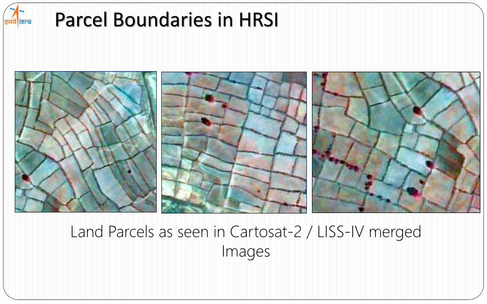
Parcel Boundaries in HRSI
Land Parcels as seen in Cartosat-2 / LISS-IV merged
Images
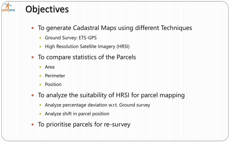
Objectives
To generate Cadastral Maps using different Techniques
Ground Survey: ETS-GPS
High Resolution Satellite Imagery (HRSI)
To compare statistics of the Parcels
Area
Perimeter
Position
To analyze the suitability of HRSI for parcel mapping
Analyze percentage deviation w.r.t. Ground survey
Analyze shift in parcel position
To prioritise parcels for re-survey

Data Used and Study Area
HRSI Data Products
• Location – Badpur, Gujarat23° 15' 59.78''N, 72° 52’ 48.07''E
23° 15' 09.93''N, 72° 53’ 48.78''E
S.NO SATELLITE SENSORSPATIAL
RESOLUTION (M)ACQUISITION
DATE
1 CARTOSAT-2 PAN 1.00 10 Feb 2010
2 GEO-EYE MX 0.50 17 Jan 2010
RoR Data Sheets
Cadastral Map
ETS-GPS Parcels

Comparative Analysis: RoR and Cadastral Maps
0
10
20
30
40
<1 1 - 3 3 - 5 > 5
No
. of
Par
cels
% Error
Comparison - RoR Entry and Cadastral Map (Old)
0
20
40
60
80
100
120
<1 1 - 3 3 - 5 > 5
No
. of
Par
cels
% Error
Comparison - RoR Entry and Cadastral Map (New)
Record of Rights Cadastral Map
Area Statistics
Comparative Analysis
Spreadsheet containing
area information
Digitization of Parcels
• RoR entries and Cadastral Maps have area deviations (Old)
• The process of geo-referencing does not influence area deviations
• The new areas, field vs Map are compatible.

Distribution of parcels area deviation (after geo-referencing) and parcel size
0
2
4
6
8
10
12
14
16
< 0.5 0.5 - 1.0 - 2.0 - 4.0 - >
Parcel Area (ha)
Perc
en
tag
e m
ea
n o
f ab
solu
te d
ev
iati
ons
Arepud (After) Birgari (After) Paddnar (After) Toyanar (After)
Comparative Analysis: RoR and Cadastral Maps

Methodology
HRSIETS-GPS
Parcel ExtractionCAD Drawing
Area, Position and Perimeter Statistics
COMPARATIVE ANALYSIS
Comparision between ETS-GPS Survey and HRSI

ResultsOBSERVATIONS ETS-GPS DERIVED PARCELS PARCEL IN HRSI HRSI DERIVED PARCELS
Parcel
58
Area (Ha) 0.78 0.80
Perimeter
(m)359.56 361.90
Centroid
shift (m)- 0.29
Parcel
139/1
Area (Ha) 0.20 0.21
Perimeter
(m)179.15 182.06
Centroid
shift (m)- 0.34

ResultsOBSERVATIONS ETS-GPS DERIVED PARCELS PARCEL IN HRSI HRSI DERIVED PARCELS
Parcel
77
Area (Ha) 0.73 0.71
Perimeter
(m)336.65 332.38
Centroid
shift (m)- 0.78
78
58
77
77

Parameter / ParcelNo.
Area (Ha)
Record of Rights ETS-GPS Survey Parcel delineated using HRSI
23 0.20 0.19 0.20
25 1.44 1.56 1.53
71 0.13 0.13 0.12
161 0.15 0.16 0.16
170 0.18 0.18 0.19
307 0.12 0.11 0.11
Results (Another study)
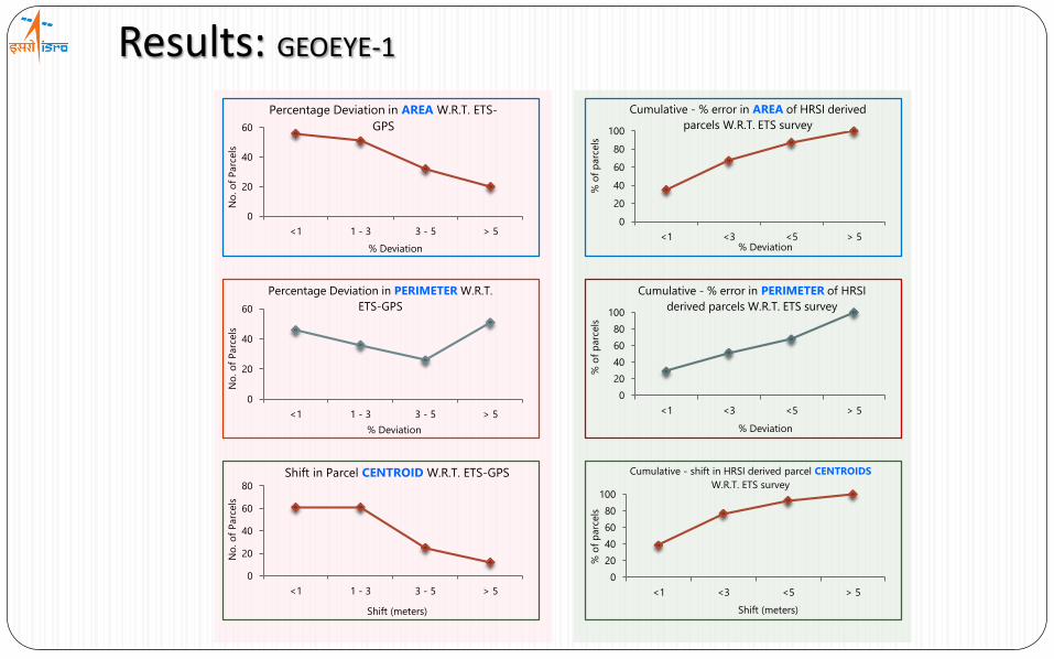
Results: GEOEYE-1
0
20
40
60
<1 1 - 3 3 - 5 > 5N
o. o
f P
arc
els
% Deviation
Percentage Deviation in AREA W.R.T. ETS-
GPS
0
20
40
60
<1 1 - 3 3 - 5 > 5
No
. o
f P
arc
els
% Deviation
Percentage Deviation in PERIMETER W.R.T.
ETS-GPS
0
20
40
60
80
<1 1 - 3 3 - 5 > 5
No
. o
f P
arc
els
Shift (meters)
Shift in Parcel CENTROID W.R.T. ETS-GPS
0
20
40
60
80
100
<1 <3 <5 > 5
% o
f p
arc
els
% Deviation
Cumulative - % error in AREA of HRSI derived
parcels W.R.T. ETS survey
0
20
40
60
80
100
<1 <3 <5 > 5
% o
f p
arc
els
% Deviation
Cumulative - % error in PERIMETER of HRSI
derived parcels W.R.T. ETS survey
0
20
40
60
80
100
<1 <3 <5 > 5%
of
parc
els
Shift (meters)
Cumulative - shift in HRSI derived parcel CENTROIDS
W.R.T. ETS survey

Results: CARTOSAT-2
0
20
40
60
<1 1 - 3 3 - 5 > 5N
o. o
f P
arc
els
% Deviation
Percentage Deviation in AREA W.R.T. ETS-
GPS
0
50
100
<1 1 - 3 3 - 5 > 5
No
. o
f P
arc
els
% Deviation
Percentage Deviation in PERIMETER W.R.T.
ETS-GPS
0
20
40
60
<1 1 - 3 3 - 5 > 5
No
. o
f P
arc
els
Shift (meters)
Shift in Parcel CENTROID W.R.T. ETS-GPS
0
20
40
60
80
100
<1 <3 <5 > 5
% o
f P
arc
els
% Deviation
Cumulative - % error in PERIMETER of HRSI
derived parcels W.R.T. ETS survey
0
20
40
60
80
100
<1 <3 <5 > 5
% o
f p
arc
els
% Deviation
Cumulative - % error in PERIMETER of HRSI
derived parcels W.R.T. ETS survey
0
20
40
60
80
100
<1 <3 <5 > 5%
of
parc
els
Shift (meters)
Cumulative - shift in HRSI derived parcel
CENTROIDS W.R.T. ETS survey

Discussions: Shortcomings
Congested settlements Visibility Constraint due to Tree Canopy

• 2.5 m satellite data
• Watershed Planning, Implementation and
monitoring
• 0.5 – 1.0 m satellite data
• Updation of Digital Cadastral Maps
• linking to Individual information / AADHAR
• Prioritization of Parcels for re-survey
• 0.25 m satellite data / Aerial Image + ETS-GPS
• Updation of Developmental Cadastral Maps
• Land Information System
• Conclusive Title
POSSIBLE APPROACHES:
• Highest accuracy• Laborious task• Huge manpower• Costly
• Maximum efforts in correcting deviations
• Lesser deviations in parcel boundaries
• Cost effective• Lesser manpower• Usable output at each level• Most optimized solution
Digital Cadastry
Developmental Cadastry
ST
EP
1A Practical Solution for Indian Scenario…?
5 Y
rs.
2 y
rs.
1 y
r.
4 y
rs.
ST
EP
2S
TEP
3
3 y
rs.
1 y
r.
1
3
1
2
3
2
3
3

Conclusions
Paradigm shift towards lab work
Satellite based methodology is a feasible solution
Distance measurement accuracy using images is better than 1:1,000
The parcel areas derived from HRSI are very close to that of ETS-GPS
As resolution increases, the accuracy of parcel mapping increases
Better accuracy can be achieved with future Indian Missions like
Cartosat-3 where the GSD is better than 30cm.
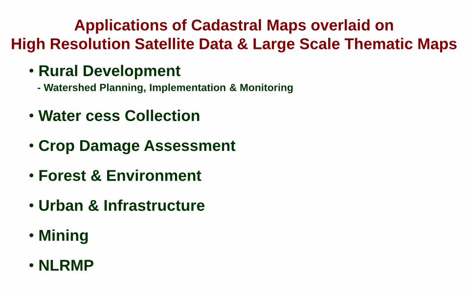
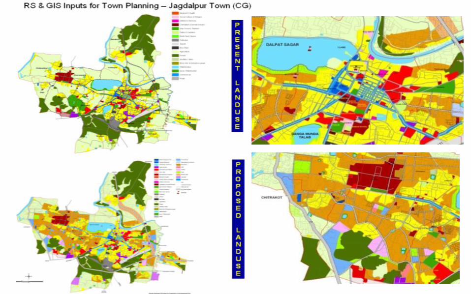
Applications of Cadastral Maps overlaid on
High Resolution Satellite Data & Large Scale Thematic Maps
• Rural Development - Watershed Planning, Implementation & Monitoring
• Water cess Collection
• Crop Damage Assessment
• Forest & Environment
• Urban & Infrastructure
• Mining
• NLRMP

NABARD SUPPORTED HOLISTIC
WATERSHED DEVELOPMENT PROGRAMME
(NHWDP) For Six Distressed Districts of
Vidarbha, MaharashtraAkola, Amravati, BuldhanaYeotmal, Washim, Wardha
36 Village Clusters / 90,000 ha (Gat-level Planning – NetPlanning Exercise)
Holistic watershed interventions combined withlivelihood support activities.
Four Resource Support Organisations (RSOs) will besupervising and guiding the 27 Project ImplementingAgencies (PIAs)
To enhance the capabilities of RSOs/PIAs to utilize thesatellite data and related information for watersheddevelopment projects.
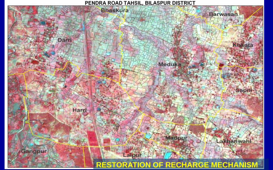
RESTORATION OF RECHARGE MECHANISM

• Restoration of recharge mechanism• Restoration of village tanks
• Catchment treatment
• Sustainance of drinking water
• Soil conservation & Restoration of Farm Ponds
•Restoration of Village tanks
USAGE OF GEO-REFERENCED VILLAGE (Cadastral)MAPSInteraction with district Officials, local people & field observation resulted in numerous applications
Identification of degraded land parcels and its impact on associated resources
Facilitate participation of local people in generating beneficiary oriented programs.
• Suitable sites for energy plantations & Catchment treatment • Suitable sites for energy / biofuel plantations
PMGSY, NREGS, SGSY


OCT 96 DEC 96 MAY 97
SUGARCANE
OTHER CROPS
SCRUB LAND
FCC of IRS LISS III
December 1996
Sugarcane crop classified using three season data
Panchganga Lift Irrigation Project Panchganga Lift Irrigation Project
Pimpalgaon Village with Cadastral Overlay,
Khadakwasla Irrigation Project
SUGARCANE MAPPING
Sugarcane crop …… 61,397 ha
Study area …………. 1,26,567 ha
• Multi-season remote season data is being operationally used to identify and map sugarcane crop in commands areas of Maharashtra.
• The geo-referenced cadastral maps overlaid on merged product of LISS3 and PAN is a simple tool to identify the existence of crop in the particular survey number.
• This technique has increased the revenue collection of Water Resource Department of Government of Maharashtra through water cess by three folds.
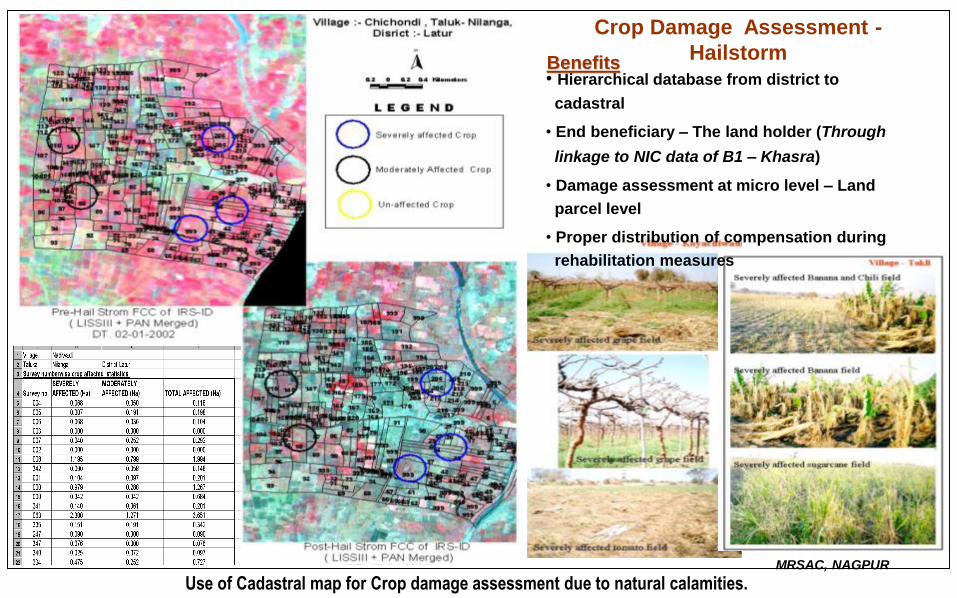
Crop Damage Assessment -
Hailstorm Benefits• Hierarchical database from district to
cadastral
• End beneficiary – The land holder (Through
linkage to NIC data of B1 – Khasra)
• Damage assessment at micro level – Land
parcel level
• Proper distribution of compensation during
rehabilitation measures
MRSAC, NAGPUR
Use of Cadastral map for Crop damage assessment due to natural calamities.

VASANTDADA SUGAR INSTITUTE, PUNE


Criterion for the demarcation of the transmission line in GIS analysis.
• Minimum of forest area be disturbed.
• Nearer to the road for easy maintenance.
• Away from the settlement/Abadi(populated area)
• The Transmission line should have minimum bends (Maximum of 60o )
• Cross minimum of Major rivers.
• Crossing of the river should be at the minimum span
• Line should cross the road, rail and river/stream in more or less perpendicular position.
• Should be at-least 5 km away from the Airport
• Avoid mining areas (active mining, dumps, etc.)
• Should be at-least 5 km away from the Reserve park/National Park boundary.
DEMARCATION OF CORRIDOR FOR CSEB 400 KV TRANSMISSION LINE
OF 1000 km IN DIFFERENT REACHES OF CHHATTISGARH
LAKHELI
to
BELAR
(285 km)


Person-Parcel-Pixel LinkageLinking of Land Records with Aadhaar – Jind Pilot Project
Aadhaar Card
Record of Rights (RoRs) Cadastral Revenue Map
Registration
CIDR Mutation
• Linking of geo-referenced Cadastral Maps with RoR and Aadhar helpsgeneration of real-time data, enabling:Profiling of land use / crop pattern; Facilitation of crop insurance
Authentication of registration process and RoR; Mortgage with financial institutions
• Any further change in land parcel/ownership can be identified/authenticated.
• Irregularities / Manipulation in documents can be detected

Action Needed • Geo referencing of Cadastral Revenue Maps
• Integration of RoRs with Georeferenced Cadastral Maps
• Computerization of Land Records
• Seeding of Aadhaar Cards with Record of Rights (RoRs)
• Generation of s/w application using Space Technology• Bhuvan POI – g-girdavari• Bhuvan web page
• Monitoring of crop growth/damage using HRSI

g-girdavari A Geo-spatial Solution for g-governance on
Bhuvan Geo-platform