uv - south dakota public utilities commission
TRANSCRIPT

Servi
ce La
yer C
redits
: CO
PYRI
GHT ©
2016
BUR
NS &
McDO
NNEL
L ENG
INEE
RING
COM
PANY
, INC.
Source: ESRI, Burns & McDonnell Engineering Company, Inc., South Dakota GIS Issued: 6/23/2016Path:
Z:\C
lients
\ESP
\Prev
ailing
Wi\9
1343
_Perm
itting
\Stud
ies\G
eosp
atial\
DataF
iles\A
rcDoc
s\EA_
Repo
rt_Fig
ures\F
igure_
1_Pr
ojectL
ocati
on.m
xd j
bell
6/23
/2016
NORTH
5 0 52.5
Miles
Figure 1Project Area
Prevailing Winds, LLCWind Energy FacilitySDPUC Application
S o u t h D a k o t a
N e b r a s k a
N e b r a s k a
Lewis and Clark LakeMissouri River
Lake Andes
Lake Andes NWR
Niobrara State Park
Marty
Wagner
Tyndall
Running Water
Armour
Avon
Corsica
Tripp
Parkston
Kaylor
Scotland
Delmont
Santee
Dante
Springfield
Milltown
Ravinia
Monowi
Verdel
£¤18
£¤281
£¤18
UV44
UV46UV37
UV12
UV25
UV52
UV50
UV50
UV50
UV44
Bon Homme
Charles Mix
Hutchinson
Douglas
Boyd
Knox
Holt
Choteau Creek
Emanuel Creek
Dry Creek
Ponca Creek
Andes Creek
Dawson CreekDr
y Cho
teau C
reek
James River
Beav er Creek
S o u t h D a k o t a
Project AreaNational Wildlife RefugeMunicipal BoundaryCounty BoundaryState Boundary

Servi
ce La
yer C
redits
: Cop
yrigh
t:© 20
13 N
ation
al Ge
ograp
hic S
ociet
y, i-c
ubed
COPY
RIGH
T © 20
16 B
URNS
& Mc
DONN
ELL E
NGIN
EERI
NG C
OMPA
NY, IN
C.
Source: ESRI, Burns & McDonnell Engineering Company, Inc., South Dakota GIS Issued: 6/23/2016Path:
Z:\C
lients
\ESP
\Prev
ailing
Wi\9
1343
_Perm
itting
\Stud
ies\G
eosp
atial\
DataF
iles\A
rcDoc
s\EA_
Repo
rt_Fig
ures\F
igure_
2_To
poMa
p.mxd
jbe
ll 6/
23/20
16
NORTH
2 0 21
Miles
Figure 2Topographic Map
Prevailing Winds, LLCWind Energy FacilitySDPUC Application
Project AreaStudy AreaAlternate Project Area

Figure 3 Wind Turbine Components
Prevailing Winds, LLC

Figure 4Turbine Construction Diagram
Prevailing Winds, LLC
I _/
I...,
' ,
'
Tower Storage Area: '80Meter Tower -3 sections (1 Base, 1 Mid, 1 Top) 94 Meter Tower -4 Sections (1 Base, 2 Mid, 1 Top)
Top towe.r secondary lilt crane
' '
Top tower and nacelle primary lift crane
I I. I I I I
\ I I I, I I I I
I I I
I I I I
\ I I I
I I \ I I I I I .
--
Servi
ce La
yer C
redits
: CO
PYRI
GHT ©
2016
BUR
NS &
McDO
NNEL
L ENG
INEE
RING
COM
PANY
, INC.
Source: ESRI, Burns & McDonnell Engineering Company, Inc., South Dakota GIS Issued: 6/23/2016Path:
Z:\C
lients
\ESP
\Prev
ailing
Wi\9
1343
_Perm
itting
\Stud
ies\G
eosp
atial\
DataF
iles\A
rcDoc
s\EA_
Repo
rt_Fig
ures\F
igure_
5_Alt
Sites
.mxd
jbe
ll 6/
23/20
16
NORTH
15 0 157.5
Miles
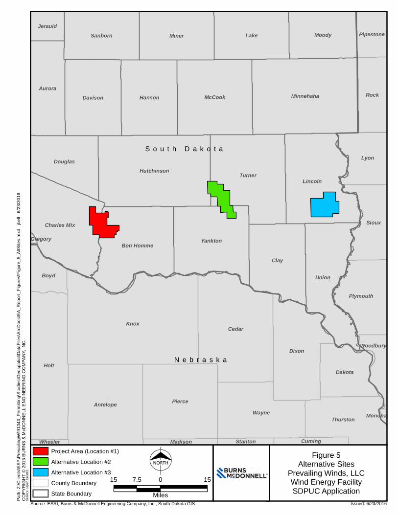
Figure 5Alternative Sites
Prevailing Winds, LLCWind Energy FacilitySDPUC Application
S o u t h D a k o t a
N e b r a s k a
Knox
Holt
Cedar
Clay
Turner
Pierce
Dixon
Union
Lincoln
Lake
MinnehahaMcCook
Hutchinson
Antelope
Miner
Wayne
Yankton
HansonDavisonAurora
Moody
Bon Homme
Lyon
Charles Mix Sioux
Sanborn
Rock
Douglas
Thurston
Dakota
Plymouth
Boyd
PipestoneJerauld
Woodbury
CumingStantonMadisonWheeler
Monona
Gregory
Project Area (Location #1)Alternative Location #2Alternative Location #3County BoundaryState Boundary

Servi
ce La
yer C
redits
: Esri
, HER
E, D
eLorm
e, Ma
pmyIn
dia, ©
Ope
nStre
etMap
contr
ibutor
s, an
d the
GIS
user
comm
unity
COPY
RIGH
T © 20
16 B
URNS
& Mc
DONN
ELL E
NGIN
EERI
NG C
OMPA
NY, IN
C.
Source: ESRI, Burns & McDonnell Engineering Company, Inc., South Dakota GIS Issued: 6/24/2016Path:
Z:\C
lients
\ESP
\Prev
ailing
Wi\9
1343
_Perm
itting
\Stud
ies\G
eosp
atial\
DataF
iles\A
rcDoc
s\EA_
Repo
rt_Fig
ures\F
igure_
8_Su
rficial
Geolo
gy.m
xd j
bell
6/24
/2016
NORTH
2 0 21
Miles
Figure 6aSurficial Geology
Prevailing Winds, LLCWind Energy FacilitySDPUC Application
A' B'
Qlts
Qlte
Qal
Qlte
Qal
Qal
QalQal
Qal
Qal - Quaternary AlluviumQlte - Quaternary Till, end moraineQlts - Quaternary Till, stagnation moraineProject AreaCounty Boundary

A' B'
LegendQal
Qlts
Figure 6b
Geologic Cross Section of Project Area
Prevailiang Winds, LLC

Servi
ce La
yer C
redits
: Sou
rce: E
sri, D
igital
Glob
e, Ge
oEye
, Eart
hstar
Geo
graph
ics, C
NES/A
irbus
DS,
USD
A, US
GS, A
EX, G
etmap
ping,
Aerog
rid, IG
N, IG
P, sw
isstop
o, an
d the
GIS
Use
r Com
munit
yCO
PYRI
GHT ©
2016
BUR
NS &
McDO
NNEL
L ENG
INEE
RING
COM
PANY
, INC.
Source: Source: ESRI, Burns & McDonnell Engineering Company, Inc., South Dakota GIS, USGS - SSURGO Issued: 6/23/2016Path:
Z:\C
lients
\ESP
\Prev
ailing
Wi\9
1343
_Perm
itting
\Stud
ies\G
eosp
atial\
DataF
iles\A
rcDoc
s\EA_
Repo
rt_Fig
ures\F
igure_
7_So
ils.m
xd j
bell
6/23
/2016
NORTH1.5 0 1.50.75
Miles
Figure 7Soil Types
Prevailing Winds, LLCWind Energy FacilitySDPUC Application
Map Unit Symbol : Map Unit NameBdF : Betts loam, 25 to 40 percent slopesBeE : Betts-Ethan loams, 9 to 25 percent slopesBn : Bon loamBn : Bon silt loamBo : Bon loam, channeledBo : Bon silt loam, channeledBr : Bonilla-Crossplain complexCeB : Clarno-Ethan loams, 2 to 6 percent slopesCeC : Clarno-Ethan loams, 6 to 9 percent slopesCmA : Clarno-Bonilla loams, 0 to 2 percent slopesCmB : Clarno-Bonilla loams, 2 to 6 percent slopesCnA : Clarno-Crossplain-Davison complex, 0 to 3 percent slopesCsB : Clarno-Ethan-Bonilla loams, 2 to 6 percent slopesDaB : Davis loam, 0 to 6 percent slopesDlC : Delmont-Talmo loams, 6 to 9 percent slopesEaA : Eakin silt loam, 0 to 2 percent slopesEdA : Enet-Delmont loams, 0 to 2 percent slopesEdB : Enet-Delmont loams, 2 to 6 percent slopes
EeB : Eakin-Ethan complex, 2 to 6 percent slopesEmE : Ethan-Betts loams, 15 to 40 percent slopesEnC : Ethan-Bonilla loams, 1 to 9 percent slopesEoD : Ethan-Davis loams, 9 to 15 percent slopesEpC : Ethan-Homme complex, 6 to 9 percent slopesEtD : Ethan-Clarno loams, 9 to 15 percent slopesEuC : Ethan-Homme complex, 6 to 9 percent slopesHaA : Hand loam, 0 to 2 percent slopesHgA : Highmore silt loam, 0 to 2 percent slopesHhB : Highmore silt loam, 2 to 6 percent slopesHlA : Highmore-Walke silt loams, 0 to 2 percent slopesHmA : Homme-Davison-Tetonka complex, 0 to 3 percent slopesHmB : Homme-Ethan-Onita complex, 1 to 6 percent slopesHnB : Homme-Ethan-Onita complex, 1 to 6 percent slopesHoA : Homme-Onita silty clay loams, 0 to 2 percent slopesHoB : Homme-Onita silty clay loams, 1 to 6 percent slopesHpB : Homme-Ethan-Tetonka complex, 0 to 6 percent slopesHpC : Homme-Ethan-Tetonka complex, 0 to 9 percent slopesHrA : Homme-Onita silty clay loams, 0 to 2 percent slopes
HrB : Homme-Onita silty clay loams, 1 to 6 percent slopesHtA : Homme-Onita-Tetonka complex, 0 to 3 percent slopesLa : Lamo silt loamOcA : Onita-Chancellor silty clay loamsOn : Mobridge silt loam, 0 to 2 percent slopesOo : Onita-Davison complexOt : Onita-Tetonka silt loamsSa : Salmo silty clay loamSm : Salmo-Napa complexTaC : Talmo gravelly sandy loam, 2 to 9 percent slopesTaE : Talmo-Delmont loams, 15 to 40 percent slopesTbE : Talmo-Ethan very stony complex, 6 to 40 percent slopesTe : Tetonka silt loam, 0 to 1 percent slopesThC : Thurman loamy sand, 6 to 15 percent slopesTn : Tetonka-Chancellor silty clay loamsW : WaterWg : Worthing silty clay loam, 0 to 1 percent slopesWo : Worthing silty clay loam, ponded, 0 to 1 percent slopes
Project AreaCounty Boundary

Servi
ce La
yer C
redits
: Sou
rces:
Esri,
DeLo
rme,
USGS
, NPS
Sourc
es: E
sri, U
SGS,
NOAA
Dry C
hotea
u Cre
ek
Choteau Creek
Emanuel Creek
Little
Ema
nuel
Cree
k
Dawson Creek
Bull Creek
Dry Choteau Creek
Little Emanuel Creek
Emanuel Creek
COPY
RIGH
T © 20
16 B
URNS
& Mc
DONN
ELL E
NGIN
EERI
NG C
OMPA
NY, IN
C.
Source: ESRI, Burns & McDonnell Engineering Company, Inc., South Dakota GIS, NHD, NWI Issued: 6/23/2016Path:
Z:\C
lients
\ESP
\Prev
ailing
Wi\9
1343
_Perm
itting
\Stud
ies\G
eosp
atial\
DataF
iles\A
rcDoc
s\EA_
Repo
rt_Fig
ures\F
igure_
8_Wa
terRe
sourc
es.m
xd j
bell
6/23
/2016
NORTH
1.5 0 1.50.75
Miles
Figure 8Water Resources
Prevailing Winds, LLCWind Energy FacilitySDPUC Application
Project AreaFreshwater Emergent WetlandFreshwater Forested/Shrub WetlandLake/PondNamed Stream with Flow Direction
No current or planned wateruses by communities, agriculture,
recreation, fish, or wildlife wereidentified within the Project Area.

Bon Homme
Charles Mix
Hutchinson
Douglas
Issued: 6/28/2016Path:
Z:\C
lients
\ESP
\Prev
ailing
Wi\9
1343
_Perm
itting
\Stud
ies\G
eosp
atial\
DataF
iles\A
rcDoc
s\EA_
Repo
rt_Fig
ures\F
igure_
9_La
ndUs
e_20
1606
28x.m
xd a
jreith
er 6
/28/20
16
NORTH
1 0 10.5
Miles
Figure 9Land Use Culture MapPrevailing Winds, LLCWind Energy FacilitySDPUC Application
Servi
ce La
yer C
redits
: USD
A FSA
-APF
O NA
IP 20
14CO
PYRI
GHT ©
2016
BUR
NS &
McDO
NNEL
L ENG
INEE
RING
COM
PANY
, INC.
Source: ESRI, Burns & McDonnell Engineering Company, Inc., South Dakota GIS, NLCD, Prevailing Winds, LLC
The following land use classifications were not identified withinthe Project Area: irrigated lands; existing and potential extractivenonrenewable resources; other major industries; residential;municipal water supply and water sources for organized ruralwater systems.
Project AreaPublic, commercial, and institutional useRural residences and farmsteads, family farms, and ranchesNoise Sensitive Land UsesPasturelands and RangelandsOther (i.e., developed, open water, wetlands, forested, shrub/scrub)HaylandsGrasslands (restored and/or undisturbed native grasslands)Land used primarily for row and nonrow crops in rotation

Servi
ce La
yer C
redits
: Sou
rce: E
sri, D
igital
Glob
e, Ge
oEye
, Eart
hstar
Geo
graph
ics, C
NES/A
irbus
DS,
USD
A, US
GS, A
EX, G
etmap
ping,
Aerog
rid, IG
N, IG
P, sw
isstop
o, an
d the
GIS
Use
r Com
munit
y
ï
ï
Wagner House
Tucek-Sykora Farmstead
Greenfield, Dr. John C., House
Metzgers, William, New Emporium
Avon
Tripp
Dante
COPY
RIGH
T © 20
16 B
URNS
& Mc
DONN
ELL E
NGIN
EERI
NG C
OMPA
NY, IN
C.
Source: Source: ESRI, Burns & McDonnell Engineering Company, Inc., South Dakota GIS, USGS - SSURGO Issued: 6/27/2016Path:
Z:\C
lients
\ESP
\Prev
ailing
Wi\9
1343
_Perm
itting
\Stud
ies\G
eosp
atial\
DataF
iles\A
rcDoc
s\EA_
Repo
rt_Fig
ures\F
igure_
10_P
ublic
Facil
ities.m
xd j
bell
6/27
/2016
NORTH
1.5 0 1.50.75
Miles
Figure 10Public Lands and Facilities
Prevailing Winds, LLCWind Energy FacilitySDPUC Application
Waterfowl Production Area (WPA)Walk in Area (WIA)Game Production Area (GPA)USFWS Wetland EasementUSFWS Conservation Easement
Project Area_̂ NRHP Locationî Churchï Cemetery
City LimitsCounty Boundary