v. monitoring and evaluation - maine.gov · v. monitoring and evaluation ... the bureau will...
TRANSCRIPT

127
V. Monitoring and Evaluation
Monitoring and evaluation are needed to track progress in achieving the management goals and objectives for the Plan area and the effectiveness of particular approaches to resource management. Monitoring and evaluation will be conducted on wildlife, ecological, timber, and recreational management efforts throughout the Western Mountains Plan Region.
Implementation of Plan Recommendations
The Bureau will develop, within two years of Plan adoption, an action plan for implementing and monitoring the management recommendations in this Plan. This will include an assignment of priorities and timeframes for accomplishment that will be utilized to determine work priorities and budgets on an annual basis. The Bureau will document annually its progress in implementing the recommendations, plans for the coming year, and adjustments to the priorities and timeframes as needed. Ecological Reserves There are currently sixteen Ecological Reserves on Bureau lands throughout the state. Ecological Reserves are established “for the purpose of maintaining one or more natural community types or native ecosystem types in a natural condition . . . and managed: A) as a benchmark against which biological and environmental change can be measure, B) to protect sufficient habitat for those species whose habitat needs are unlikely to be met on lands managed for other purposes; or, C) as a site for ongoing scientific research, long-term environmental monitoring, and education.” (Title 12, Section 1801). The Maine Natural Areas Program (MNAP) is conducting long-term ecological monitoring within these Reserves. There is one Ecological Reserves in this Region: The Mahoosuc (Carlo-Speck) Ecological Reserve. The MNAP conducted a natural resource inventory on this Ecological Reserve in 2009 as part of the reserved lands management planning process. MNAP is also monitoring these lands as part of its long term monitoring of Ecological Reserves to monitor ecological change within Ecological Reserves and to compare Ecological Reserves to areas under different management regimes. Baseline data was collected using permanent plots at the Mahoosuc Ecological Reserve. These areas will be re-inventoried periodically, according to schedules developed by the Bureau and MNAP. Recreation Data on recreational use is helpful in allocating staff and monetary resources for management of the properties throughout the Plan area, and in determining the public’s response to the opportunities being provided. In addition to gathering data on use, the Bureau will monitor public use to determine:
(1) whether improvements to existing facilities or additional facilities might be needed and compatible with general objectives;

128
(2) whether additional measures are needed to ensure that recreational users have a high quality experience (which could be affected by the numbers of users, and interactions among users with conflicting interests);
(3) whether use is adversely affecting sensitive natural resources or the ecology of the area;
(4) whether measures are needed to address unforeseen safety issues; (5) whether changing recreational uses and demands present the need or opportunity for
adjustments to existing facilities and management; and (6) whether any changes are needed in the management of recreation in relation to
other management objectives, including protection or enhancement of wildlife habitat and forest management.
Wildlife The Bureau, through its Wildlife Biologist and Technician, routinely conducts a variety of species monitoring activities statewide. The following are monitoring activities that are ongoing or anticipated for the Western Mountains Region:
(1) The Bureau will cooperate with IF&W in the monitoring of game species, including deer, moose, grouse, and black bear;
(2) The Bureau will identify and map significant wildlife habitat such as vernal pools and den trees in the process of developing its detailed forest management prescriptions. The boundaries of any sensitive natural communities will also be delineated on the ground at this time. Any significant natural areas or wildlife habitat will then be subject to appropriate protections.
Timber Management Local work plans, called prescriptions, are prepared by professional foresters in accordance with Bureau policies specified in its Integrated Resource Policy, with input from other staff. These documents are then peer-reviewed prior to approval. Preparation and layout of all timber sales involve field staff looking at every acre to be treated. Trees to be harvested are generally hand marked on a majority of these acres. Regional field staff provide regular on-site supervision of harvest activities, with senior staff visiting these sites on a less frequent basis. After the harvest is completed, roads, trails, and water crossings are discontinued as appropriate, although some management roads may remain open to vehicle travel. Changes in stand type resulting from the harvest are then recorded so that the Bureau’s GIS system can be updated. The Bureau is currently developing a post-harvest monitoring plan to assist forest managers in assessing harvest outcomes on all managed lands. The monitoring plan will also address water quality and Best Management Practices (BMPs) utilized during harvest activities. Third party monitoring is done mainly through the forest certification programs of the Forest Stewardship Council (FSC) and the Sustainable Forestry Initiative (SFI). Each program conducts rigorous investigations of both planning and on-ground practices. An initial audit by both programs was completed in 2001, with certification awarded in 2002. A full re-audit of both programs was conducted in the fall of 2006 with certification granted in 2007. The Bureau is also subject to compliance audits during the 5-year certification period.

129
VI. Appendices
A. Public Process: Advisory Committee Members; Public Comments and Bureau Responses B. Statutes and Agreements C. IRP Descriptions D. Glossary E. References F. Allocation Maps G. MNAP Natural Resources Inventory (under separate cover; available on request) H. Timber and Renewable Resource Documents (available on request)
o Compartment Examination Manual o Prescription Manual and prescriptions for the Western Mountains Region lands o Timber Sale Manual o Forest Inventory data o Forest Certification Reports from Sustainable Forestry Initiative, Forest
Stewardship Council (2002,2007 and 2009). o Maine Bureau of Parks and Lands Forest Certification Manual o Soil surveys o Forest Laws of Maine o Best Management Practices Manual

130
Appendix A: Public Review Process - Advisory Committee Members; Public Comments and Bureau Responses
The Advisory Committee Members: Jeremy Sheaffer The Wilderness Society Ken Hotopp Mahoosuc Land Trust Mike Ewing Maine Appalachian Trail Club Paul Casey Umbagog National Wildlife Refuge Mac Dudley Maine Snowmobile Association Ernie DeLuca NextEra Energy Cathy Mattson Hawk Metheny Appalachian Trail Conservancy Joseph May Dave Herring Maine Huts and Trails Christopher Nichols Seven Islands Marc Edwards University of Maine Cooperative Extension Dave Boucher Inland Fisheries and Wildlife Gordon Gamble Bayroot/Wagner Forest Management Don Kleiner Maine Professional Guides Association Kevin Slater Mahoosuc Guide Service Shelby Rousseau Rangeley Lakes Heritage Trust Dina Jackson Androscoggin Valley Council of Governments Kent Nelson Maine Forest Service Jeff Stern Androscoggin River Watershed Council Dan Mitchell ATV Maine Andrew Norkin Appalachian Mountain Club
Maine Department of Conservation
Bureau of Parks and Lands WRITTEN PUBLIC COMMENTS
Summary of Written Comments on the First Draft Plan (written comment period from August
25 to September 28, 2010) and Final Draft Plan (written comment period November 20 to December 24, 2010).
Comments have been paraphrased, and similar comments have been consolidated
Comment Response General Management Plan Comments From: Kent Nelson, Maine Forest Service, Forest Protection Division • Unauthorized / unattended campfires, increases
in recreational use and nearby camps and limited access increase the threat of wildfires to the Western Mountains region.
• The Bureau appreciates the consideration of MFS of reducing environmental impacts of fire suppression in special protection and backcountry non-mechanized areas. The

131
The MFS will continue to maintain two remote landing zones for fire protection / emergency medical evacuation. Each year, the MFS and local fire departments should review the locations of ecologically sensitive areas and include maps indicating “special protection” and “backcountry non-mechanized” areas in district fire plans. Emphasis should be placed on using wildfire suppression techniques that reduce environmental impacts. The BPL should continue efforts to support fire prevention education, including in kiosks. The BPL should continue to inform MFS of road closures, supply gate keys or combinations, and provide adequate turn around room when feasible. The location and number of authorized permit sites should continue to be reviewed annually by both the BPL and the MFS.
• The MFS agrees with the need for a boat ramp on Beaver Mountain Lake and in the event of a wildfire, would benefit from the access to the water. Perhaps a dry hydrant should also be considered for this location.
•
Bureau will continue to work with the MFS on strategies to minimize wildfire risks and facilitate fire suppression.
From: Penny Gray, Vice President, Harraseeket Inn and Lisa Lindsay, Wilton • Large wind installations are being proposed on
mountain tops and ridge lines throughout the western mountains. These turbines and their accompanying infrastructure threaten the region’s scenic beauty, recreation opportunities and economy. The Bureau should take this into account when planning for the future of these lands.
• Wind development on private lands in the state is within the jurisdiction of the Maine Department of Environmental Protection and Maine Land Use Regulation Commission. No wind projects are proposed for Parks or Public Reserved Lands in the Western Mountains region, therefore, the management plan does not address this issue.
Comments on Mahoosuc Unit and Grafton Notch State Park Comments on ORV use in the southern portion of Mahoosuc Unit From: Dr. Thomas Dawson, Campowner • The plan should allow ATV riders to use the • The plan allows ATV riders as well as other

132
Bull Branch Road and the Sunday River Road (otherwise known as the Coburn Field Road) in the Mahoosuc Unit.
motorized vehicles to use the Bull Branch Road to the Wright Trail parking lot and the Sunday River road. The Sunday River Road is designated as a management road with shared use status—which means it is a road the Bureau maintains for timber management access, however, it is open to use by the public for use of passenger vehicles, ATVs, horses and bicycles.
The Bull Branch Road is a public use road, as it provides access for recreational destinations on the public lands—the Wright Trail and Frenchman’s Hole. The Bull Branch Road—from Twin Bridges to the Wright Trail parking area—will be maintained as a public use road in this plan, open to passenger vehicles, ATVs and bicycles. Beyond the Wright Trail parking lot the road becomes a network of management roads closed to public vehicular use or ATV use.
From: John Chandler, Campowner • Management roads within the timber
management areas off the Sunday River Road in Riley Township should be open to light-weight ATVs. These areas are not very scenic, not used by hikers, and hunters need to be able to take ATVs in to retrieve game. Light weight ATVs do not cause the kind of damage to roads that Jeeps do. Public lands should be made more accessible, not less, for those who are older and less physically fit. In the Bull Brach timber management area, access roads should be kept open for hunters and fishermen, and at the very least for emergency vehicles.
• The Bureau Integrated Resource Policy (IRP), adopted in 2000, is a policy and planning document which guides management recommendations in this and other management plans. Guidance from the IRP on ATV use on public lands includes the following from pp. 62-63: “A1. Recreational use of All-Terrain Vehicles (ATVs) shall be allowed on gravel roads designated for such use by the Bureau. All gravel roads shall be so designated, except those located on Public Reserved and Nonreserved Lands that are surrounded by privately-owned lands over which the transportation of ATVs is prohibited, those deemed unsuitable for ATV use by the Bureau due to environmental or safety concerns or incompatibility with other uses, and those located in areas allocated as Special Protection Natural or Historic/Cultural Areas and Backcountry Non-mechanized Areas. Gravel roads in areas allocated for Special Protection

133
Ecological Reserves and Remote Recreation shall be designated only when the road segment is open for use by all public vehicles or meets the three criteria listed under A.2.
A2. Off-road ATV use shall be allowed only on trails designated for such use by the Bureau. Designation of ATV trails shall be considered during the management planning process or upon request. Designated trails may be allowed in areas allocated for Special Protection Ecological Reserves or Remote Recreation Areas when all of the following criteria are met: no feasible alternative exists, no significant impact on protected resource values will occur, and the designated trail will provide a crucial link in a significant trail system.”
• Consistent with A1 of the IRP, the Bureau has designated all gravel roads in the Mahoosuc Unit—the Sunday River Road and the Bull Branch Road to the Wright Trail parking lot—as shared use roads and thus open to ATVs (as well as passenger vehicles, horses and bicycles). Consistent with A2, the Bureau has chosen not to build ATV trails in the Mahoosuc Unit, because the vision and management direction for the Mahoosuc Unit has since the 1988 management plan, and continues to be to manage the recreation for back-country recreation.
From: Jeff Stern, Androscoggin River Watershed Council • The Plan should address erosion caused by
ORV use in the Mahoosuc Unit---particularly in the southern portion—in a number of ways. The recommendation in the final draft plan should be strengthened to say the Bureau “will” apply the methods listed to eliminate ORV use instead of “could”. Retiring and blocking BPL timber management roads will be the most effective method. Establishing an IFW warden presence is not likely to occur because of IFW budget constraints.
• The final draft recommendation of reaching out to ORV clubs should be expanded to include assigning the proposed recreation coordinator the task of developing an ORV plan for roads
• The Bureau listed methods that could be considered in eliminating the ORV use off of the Sunday River Road. The management plan provides guidance to Bureau staff, providing clear management objectives, but providing a degree of flexibility for Bureau staff in implementing objectives. Effective methods for accomplishing the management goal of working to eliminate unauthorized ORV use in the Unit will be determined by staff and may include blocking and retiring roads, reaching out to clubs, enforcement or a combination of these methods.
• This management plan recommends allowing ORVs on the Bull Branch Road up to the

134
that are acceptable or off-limits to them and ARWC would be willing to assist in this task.
• Additionally, BPL should hold erosion control seminars for ORV user groups in concert with the DEP Non-point Source Training and Resource Center, and ARWC is willing to help organize and publicize. The placing of mulch along bare areas of stream banks by some ORV users shows there is already some willingness and awareness to address this issue.
Wright Trail parking lot, and on the Sunday River Road. It recommends allowing these uses to continue, but not promoting the Mahoosuc Unit as a motorized trail destination. Therefore, developing an ORV plan for the Unit will not be consistent with this management objective.
• The Bureau’s Off Road Vehicle Program (ORV) staff members are trained and certified by the DEP Non-point Source Training and Resource Center in erosion and sedimentation control practices. The ORV program holds field seminars for ORV clubs on Best Management Practices (BMPs) for trail construction and maintenance. ARWC and any other interested parties are encouraged to contact the Bureau’s ORV program about upcoming seminars.
From: Joint comments from: Kevin Slater and Polly Mahoney of Mahoosuc Guide Service, Caroline Blair-Smith of Outward Bound, Abi Morrison, Riley Landowner • The ATV trails partly on state land are mapped
but not well marked. They should be clearly designated and coordinated with state land managers for construction and maintenance.
• Any ATV trails in the Mahoosuc Unit other than on gravel shared-use roads as mentioned responses to Stern and Chandler above, are un-authorized trails. This management plan recommends allowing ORVs on the Bull Branch Road up to the Wright Trail parking lot, and on the Sunday River Road. It recommends allowing these uses to continue, but not promoting the Mahoosuc Unit as a motorized trail destination.
From: Joint comments from: Kevin Slater and Polly Mahoney of Mahoosuc Guide Service, Caroline Blair-Smith of Outward Bound, Abi Morrison, Riley Landowner • A designated snowmobile trail corridor is
needed through the Sunday River valley on state lands to the Route 2 corridor.
• The Bureau can accommodate snowmobile trails on areas of the Mahoosuc Unti that are allocated for Timber Management as the dominant use. Interested parties should work with the regional staff to find appropriate routes that do not conflict with other uses described in this Plan.
Comments on Provision of information for recreationists From: Andy Bartleet, Outward Bound • The Bureau should add a specific statement in
the plan about improving the Bureau’s website to provide recreationists information on trail conditions, campsites, logging operations, gate
• A statement has been added to the plan to emphasize the importance of adding greater information for recreation on the Bureau’s website on Mahoosuc. The Bureau also

135
closings, rules and guidelines, and other information relevant to recreational planning. Greater resources should be allocated for updating and distributing information and education for users. Organized groups such as Outward Bound have to coordinate many group itineraries and so any information to prevent having to change plans during the trips is important.
encourages organized recreational groups to contact the Western Region Public Lands office in Farmington as needed to get information on topics such logging operations, gate closings, and other matters related to trip planning.
From: Appalachian Mountain Club • The Bureau should coordinate with the
Mahoosuc Initiative and local businesses and chambers of commerce in improving information for recreationists.
• The Bureau agrees that coordinating with the Mahoosuc Initiative members and local businesses and chambers of commerce could increase and improve information for recreationists. Language has been added to the Plan suggesting this be explored..
Comments on Nordic skiing From: Joint comments from: Kevin Slater and Polly Mahoney of Mahoosuc Guide Service, Caroline Blair-Smith of Outward Bound, Abi Morrison, Riley Landowner, Comments from the Bethel Outing Club • The Upper Sunday River valley is a unique
resource for Nordic skiing due to its high snowfall (early and late in the season), its topography and logging road network. It is the eventual terminus of Maine Huts and Trails. The area has the potential of a ski network of statewide significance.
• The Management Plan language reflects the value of this area for Nordic skiing and has also incorporated in the management recommendations the intent to partner with local groups to designate routes for Nordic skiing.
From: Bethel Outing Club, Mahoosuc Land Trust, and Joint comments from: Brad Clarke of Bethel Outing Club, Kevin Slater and Polly Mahoney of Mahoosuc Guide Service, Landon Fake of Bethel Trails Committee, Caroline Blair-Smith of Outward Bound, Steve Keane of Telstar Nordic Team, Jeremy Nellis of Gould Academy Nordic program and Mac Davis of Maine Wilderness Guides Association • The Bull Branch Road should be managed for
Nordic skiing and non-motorized travel between December 1 and March 31, except when management activities require their use. There is conflict when wheeled vehicles access this road in winter.
• The Bureau supports this request. The Management Plan recommendations have been edited to specify that the Bull Branch Road will be managed for Nordic skiing and other non-motorized uses beginning December 1, or after the first significant snowfall, which ever is later.
From: Joint comments from: Brad Clarke of Bethel Outing Club, Kevin Slater and Polly Mahoney of Mahoosuc Guide Service, Landon Fake of Bethel Trails Committee, Caroline Blair-Smith of Outward Bound, Steve Keane of Telstar Nordic Team, Jeremy Nellis of Gould Academy Nordic program and Mac Davis of Maine Wilderness Guides Association • Nordic ski trails in the Bull Branch Valley and
over Miles Notch need to be groomed to be • Currently, there is no specific proposal for
locating a groomed Nordic ski trail system

136
usable by the majority of the public. The plan should have language to allow mechanized grooming in the Ecological Reserve and across the Backcountry Non-mechanized allocation in Miles Notch, dependent on routes and management that protects the ecological integrity of the area that these allocations were designed to protect. Or specify that the Special Use permitting process could allow for grooming, if this is the case.
other than the general location of the Bull Branch valley. The resource allocations for the plan in this area are a blend of ecological reserve, wildlife, backcountry non-mechanized, and timber management. The Bureau will be working with local Nordic ski interests to designate routes and allow for trail grooming. The Bureau and Nordic ski groups will have to consider many factors in locating a trail—such as up-coming timber operations and terrain. Under the resource allocation system, grooming for Nordic skiing would be easily allowed in the timber dominant allocation, and in the wildlife allocation on existing management roads. If, in the process of designating specific routes for ski grooming, it is determined that there is a desirable route that extends into the ecological reserve or backcountry non-mechanized allocations, the Bureau will need to consider whether this is consistent with current policy and statutory guidance. The Ecological Reserve statute and the Bureau’s IRP are the guiding documents the Bureau will consult to consider new recreational uses in the Ecological Reserve, and IRP description of the Backcountry Non-mechanized allocation will be consulted for decisions on mechanized grooming in the Backcountry non-mechanized area. Both of these can be found in the Appendix.
From: Joint comments from: Brad Clarke of Bethel Outing Club, Kevin Slater and Polly Mahoney of Mahoosuc Guide Service, Landon Fake of Bethel Trails Committee, Caroline Blair-Smith of Outward Bound, Steve Keane of Telstar Nordic Team, Jeremy Nellis of Gould Academy Nordic program and Mac Davis of Maine Wilderness Guides Association • The plan should specify a person or position
with whom the local backcountry recreation groups should coordinate on Nordic trails. Discussions are occurring with Bill Haslam, but the plan should formalize this.
• Pete Smith, the Western Region Lands Manager, based in Farmington or his designee is the contact for recreation on Public Reserved Lands in the Western region (including the Mahoosuc Unit) pending the creation of a designated recreation coordinator.
Comments on snowplowing, gating and parking to improve recreational access From: Bethel Outing Club, Mahoosuc Land Trust • The plan should improve recreational access
and use by increasing winter parking access to motorized and non-motorized trails from Grafton Notch State Park, add new year-round
• The Bureau appreciates these specific requests for access improvements. Some of these comments are addressed in plan recommendations (see Grafton Notch State

137
roadside parking below Screw Auger Falls, plow the mouth of the Quonset Hut Road and close the gate in summer, close the gate at the foot of the Cable Road in summer and expand the parking area. These recommendations will address safety issues associated with overflow parking as well.
Park and Mahoosuc Unit Issues and Recommendations. ) The recommendation addressing the issue titled ‘winter use needs’ recommends gathering more information about winter use, communicating with DOT on plowing needs, and working with partners groups. The Bureau recognizes that various interests may have differing views about appropriate access, and defers decisions on exact access improvements pending additional research and collaboration with these interests. The recommendation addressing the issue titled ‘Bureau staff limitations’ speaks to exploring the feasibility of providing a recreation coordinator, who could work on issues related to recreation management.
Comments on the Recreation Coordinator From: Appalachian Trail Conservancy • The Recreation Coordinator should be a top
priority in the plan. If the Bureau can’t fully fund this position, they should coordinate with AMC or the Mahoosuc Initiative on a jointly funded position.
• Language has been added to the recreation coordinator recommendation to explore pursuing joint funding with the Mahoosuc Initiative for this position.
From: Joint comments from: Brad Clarke of Bethel Outing Club, Kevin Slater and Polly Mahoney of Mahoosuc Guide Service, Landon Fake of Bethel Trails Committee, Caroline Blair-Smith of Outward Bound, Steve Keane of Telstar Nordic Team, Jeremy Nellis of Gould Academy Nordic program and Mac Davis of Maine Wilderness Guides Association • A Bureau staff person should be designated in
the interim period until the recreation coordinator position is filled to work with the chamber of commerce and local recreation groups on: public information, visitor use information, plowing for winter recreation, developing Nordic and other recreational trails that connect to local towns.
• The recreation coordinator position recommendation should be revised to direct the Bureau to explore options for joint funding of the position with local recreation and tourism organizations—this approach will be more likely to lead to funding.
• The Bureau will designate a staff person to serve this role until resources are secured for a dedicated recreation coordinator. The Bureau will explore options for funding, including joint funding of the position with local recreation and tourism organizations, as suggested.
From: Gordon Gamble of Wagner Forest Management • Coordination is merited, but should be done by
the park manager, or other existing personnel or recreation organizations. A new position should
• Language in the plan under the ‘Recreational Resource Issues’ and ‘Grafton Notch State Park and Mahoosuc Unit Issues and

138
not be created for this. Part of the problem is there are beginning to be too many trails.
Recommendations’ describes the current staff limitations and the challenges that would be involved with implementing recreation plan recommendations, including more coordination between managing partners, under the current staff levels. The plan recommendation calls for investigating creating a new permanent position that would serve the larger Western Maine region working on similar coordination and recreation management issues throughout the region, not just in Grafton and Mahoosuc. Collaborative funding may be pursued for this position.
Miscellaneous Comments on Recreation in Grafton and Mahoosuc From: Bethel Outing Club • A detailed recreation plan for the Upper Sunday
River and Bull Branch valley should be developed using local input to allow development of permanent trails. This area is potentially of statewide recreation significance and careful planning can prevent negative impacts to recreation during harvest operations.
• The public process for this management plan was an opportunity to get input from the public for planning and management for recreation. Management recommendations from this plan guide the Bureau toward performing more detailed recreational planning in many areas, including working with local groups in designating routes for Nordic skiing in the Bull Branch valley and allowing for grooming. Additionally, the Bureau will review the status of the plan recommendations and any new emerging issues with the advisory committee every five years after plan adoption. This will be another opportunity for assess progress in the Bureau’s recreation planning.
From: Appalachian Mountain Club • The Bureau should work with the Mahoosuc
Initiative to examine winter uses for better facilitation of winter recreation.
• The plan recommends working with local groups in exploring winter recreation needs. The Mahoosuc Initiative—which includes Mahoosuc Land Trust, Androscoggin River Watershed Council, Northern White Mountain Chamber of Commerce, Appalachian Mountain Club, Appalachian Trail Conservancy, the Tri-county Community Action program and the Wilderness Society—is a large and diverse group. The Bureau would welcome a more formal relationship with the Mahoosuc Initiative to improve communication. This might , include having the Mahoosuc Initiative designating which member or members would be appropriate to

139
represent the Initiative in communicating with the Bureau on winter recreational needs, coordination and information sharing.
From: Joint comments from: Brad Clarke of Bethel Outing Club, Kevin Slater and Polly Mahoney of Mahoosuc Guide Service, Landon Fake of Bethel Trails Committee, Caroline Blair-Smith of Outward Bound, Steve Keane of Telstar Nordic Team, Jeremy Nellis of Gould Academy Nordic program and Mac Davis of Maine Wilderness Guides Association • The Bureau should actively discourage use of
popular bootleg trails. This can be done with signage and gating. The trail to Miles Notch from the Quonset Hut road could be discouraged with a gate—it is heavily used, poorly sited and badly eroding.
• The Plan has been amended to recommend that the Bureau explore ways to limit access to areas with erosion problems.
From: Appalachian Trail Conservancy • If the Bureau cannot find funding to hire an
additional summer staff person or intern, they should consider assisting with funding for the two seasonal staff that the AMC provides in Mahoosuc (one is a Speck Pond Caretaker, the other is a Mahoosuc Rover, who maintains the Full Goose and Carlo Col campsites and trails south into New Hampshire).
• The plan recommends increasing and improving information for backpackers and hikers in Grafton Notch State Park and the Mahoosuc Unit. Possible methods include exploring designating a summer staff person, ridge runner or intern to rove the trails and spend time in the Park AT parking lot, giving information to hikers on trail conditions, campsites etc. The Bureau would be glad to collaborate with partners in the Grafton Mahoosuc Trails Coalition including AMC in pursuing funding for this position. The Speck Pond caretaker and Mahoosuc Rover provide excellent information and service for hikers and backpackers in the southern portion of the Bureau’s ownership and in the New Hampshire portion of the Mahoosuc Appalachian Trail.
However, there is additional need for a summer position to spend time in the Grafton Notch State Park AT parking lot and along trails throughout the Mahoosuc Unit, including the northern portion of the Bureau’s Mahoosuc Unit AT and the Grafton Loop Trail.
From: Appalachian Mountain Club • AMC is very interested in stronger partnerships
in looking at potential management models for trails (such as alpine boardwalks on the Grafton Loop Trail).
• The Bureau looks forward to working with AMC and other partners in the upcoming Grafton Mahoosuc Trail Coalition to explore various trail management techniques to work toward an exemplary standard of balancing

140
recreation and environmental protection in Grafton and Mahoosuc.
Comments on the Grafton and Mahoosuc Trail Coalition From: Appalachian Trail Conservancy • We request to be on the Coalition. We work
with many of the groups on the coalition, and have much experience working with partners along the Appalachian Trail, and also provide AT clubs funding for trail maintenance.
• The Bureau would appreciate the addition of the ATC to the Grafton and Mahoosuc Trail Coalition. The Coalition will be focused on existing trails and developing and implementing trail management plans and coordinating in the grant application process. Improving public information and sharing visitor use information are also possible topics. The ATC’s on-going work with the Bureau, MATC and AMC, experience working with partners along the entire AT, and assistance in providing funding to AT clubs for trail maintenance, would all make the ATC an appropriate member of the coalition. The Plan has been revised to include the ATC as part of the proposed Coalition.
From: Appalachian Mountain Club • AMC supports the Coalition, but believes it
should include the Mahoosuc Initiative. • The Grafton Mahoosuc Trail Coalition will
have a representative from Bureau Parks, Bureau Lands, AMC, MATC, ATC and MLT. Three of these members—AMC, ATC and MLT—are also members of the Mahoosuc Initiative. In the interest in keeping the Coalition a workable size, the Bureau would ask the three members who also are part of the Mahoosuc Initiative to consider also representing the MI interests, if they are any different from their own.
Comments on Mahoosuc resource allocations From: Mahoosuc Land Trust, The Wilderness Society, Appalachian Mountain Club, Bethel Outing Club • We support the new Backcountry Non-
motorized designation on the ridgeline from Old Speck to Slide Mountain.
• The Bureau appreciates the support of these organizations for this allocation, but would like to note that the allocation is actually Backcountry Non-mechanized.
From: Mahoosuc Land Trust, The Wilderness Society, Appalachian Mountain Club, Bethel Outing Club • We support the addition of a Backcountry Non-
motorized designation including the Bull Branch watershed upstream of the Wright Trail parking lot all the way east to Riley Hill and
• The dominant allocations for the Bull Branch watershed area are a combination of Special Protection Ecological Reserve, Backcountry Non-mechanized, Wildlife and Timber

141
private lands. There is an opportunity here to restore a complete montane watershed to a wild, natural state. Hunting, fishing, mountain biking and machine-groomed Nordic skiing should be allowed uses (however, AMC requested backcountry un-groomed skiing on existing roads should be allowed).
Management. The Bureau, through the management planning process has determined these allocations to be most appropriate dominant uses in their respective locations, considering the ecological, wildlife, recreational and timber values of the landscape. Secondary allocations include: Backcountry Non-mechanized in the Ecological Reserve, Visual Class I along the Bull Branch up to the point of confluence of Speck Pond Brook Stream and along the Sunday River, and Visual Class II on Timber Dominant allocations. Hunting, fishing and un-groomed skiing are allowed uses in all of the Bull Branch allocations. Mountain biking and machine grooming are not authorized uses under Ecological Reserve and the Backcountry Non-mechanized allocations. However, exceptions can be made under certain circumstances. The ITS 82 snowmobile trail that crosses the Backcountry Non-mechanized allocation north of Sunday River Whitecap was allowed to continue because it is an existing use, so a Developed Recreation was created for this existing use.
This management plan recommends working with Nordic ski interests that have expressed interest in developing the valley for groomed Nordic skiing. No specific routes have been identified yet, although the management road system in the timber dominant area has been mentioned as well as a possible connection over Miles Notch at the east end of the Backcountry Non-mechanized allocation. Factors such as terrain and Bureau timber management needs must be considered before routes can be designated. If, in the process of designating specific routes for ski grooming, it is determined that there is a desirable and feasible route that extends into the Ecological Reserve or Backcountry Non-mechanized allocations, the Bureau will need to consider whether this use is allowed under the current statutes and Bureau policy. (see Appendices B and C)

142
From: Abi Morrison, Riley landowner • Consider putting the Upper Bull Branch valley
in a wilderness type of protection. The forest products value of this area is low due to: heavy cutting prior to state acquisition, slow regeneration of high value wood, and the rugged terrain. The recreational value is much higher, due to the growing popularity of non-motorized recreation such as mountain biking, snowshoeing, backcountry skiing, hunting and fishing. The popularity of the valley is increasing with the advertising of the Frenchman’s Hole swimming area.
• Please see the response above, and the dominant allocation and recreation allocation maps for an explanation of allocations and recreational uses in the Bull Branch valley. The forest products value is discussed in the plan’s ‘Timber Resources’ section. To briefly paraphrase, some of the harvests by land owners prior to state acquisition were quite heavy. However, quality and growth of hardwood type, which makes up 84 percent of the regulated acres in the Mahoosuc Unit (acres subject to timber harvesting) is as good as anywhere on Bureau lands, though quality is lower on some of the steeper land higher up on the mountains. The Bureau manages timber resources where allocated (in the Bull Branch and elsewhere) to provide a diverse forested environment and generate high quality—high value products to support Bureau operations and the local economy.
From: Mahoosuc Land Trust, The Wilderness Society, Appalachian Mountain Club, Bethel Outing Club • We request the designation of Backcountry
Non-motorized on the watershed of Wight Brook, excepting the un-named east tributary and associated snowmobile trail, and all lands above 2500 feet on East and West Baldpate. Timber management is not compatible with recreation here. (AMC requested all lands above 2700 feet and extensive steep slopes on the south side of the ridge be allocated non-timber zones).
• The allocations around the Baldpate Mountains and the Wight Brook area have been amended in the final plan as follows:
• Special Protection-Natural Area on the
Baldpates containing the Heath Alpine Ridge and Subalpine Slope Bog communities, and surrounding exemplary Sub-Alpine Fir Forest natural communities ranked S3. Backcountry Non-mechanized is a secondary allocation.
• Special Protection-Historic Cultural for 100
feet on each side of the Appalachian Trail and side trails (the Grafton Loop Trail).
• Backcountry Non-mechanized for the 400 foot
buffer extending from the 100 foot Special Protection zone designated on either side of the Appalachian Trail from the point entering the Unit east of Table Rock to an area defined around Baldpate Mountain by the 2,700 foot elevation contour, except where defined as Special Protection.

143
• Backcountry Non-mechanized for a buffer area
around the Special Protection areas on the west and east peaks of Baldpate Mountain and the Sub-alpine Fir Forest special protection area west of Baldpate, extending down to an elevation of 2700 feet.
• Wildlife Dominant for the Wight Brook for
330 feet on each side. • Remote recreation for a 400 foot buffer beyond
the 100 foot special protection area on each side of the AT (except where designated Special Protection, or Backcountry Non-Mechanized) and Grafton Loop Trail (except where designated Special Protection, or Backcountry Non-Mechanized or Wildlife Dominant). This area is also subject to Visual Class I (where not already contained within a larger Special Protection or Backcountry Non-mechanized Dominant Allocation).
• Timber Dominant for the remaining areas.
The area around the Baldpates and the Wight Brook is rich in a variety of resources—from ecological resources in the sensitive alpine communities to the Backcountry recreational values of the Appalachian Trail and surrounding wild, scenic environment, to the valuable timber resources of an area that grows high quality hardwood timber. The dominant and secondary allocations in the area are designed to achieve an exemplary balance of recreational uses and management while protecting natural resource that are most sensitive to recreation and management activities.
From: Gordon Gamble of Wagner Forest Management • All inoperable areas should not be designated as
backcountry, as has been recommended by some advisory committee members, because operability is a moving target as technologies and markets evolve, and timber allocation does not preclude backcountry recreation.
• In the process of designating the resource allocations and management activities for each acre of public lands, the Bureau considers multiple uses, and the features and resources unique to different Public Reserved Lands and within different portion of each Land Unit. In areas designated as Backcountry Recreation,

144
the scenic qualities, remoteness, and opportunities for primitive recreation were considered as important resources, as well as considering the timber resources and inoperability of some of these areas. 14,617 acres of the Mahoosuc Unit are timber dominant, with timber management a secondary allocation in wildlife and remote recreation allocations. This gives the Bureau adequate opportunity for timber management and is an appropriate balance of multiple uses on public reserved lands.
From: Mahoosuc Land Trust, The Wilderness Society • Provide better protection of riparian zones with
a 200 foot wide “no-cut’ Visual Class I zone for second order and larger streams. Extend these zones upstream to meet Special Protection or Backcountry zones. The current wildlife allocation does not have standards to prioritize conservation of these streams, and the Bureau’s Visual no-cut zone along trails would allow fishermen, hunters and hikers to enjoy the appearance of an un-managed wild stream.
• The portion of Sunday River within the Unit, the Bull Branch Stream up to the point of confluence of Speck Pond Brook Stream, and the Cataracts Trail (along the Frye Brook) are given Visual Class I as a secondary allocation, due to the recreational value of these streams. Visual Class I does not prohibit timber harvesting. The secondary allocation of Visual Class I is a variable width buffer along recreational features (such as shorelines and trails) and public use roads, in which any timber management is directed to retain the appearance of an un-managed forest.
In the Bureau’s wildlife dominant allocation, which is applied as the dominant allocation 330 feet on shorelines of lakes, ponds and other waterbodies including either side of major streams (and in the case of the Mahoosuc Unit, due to steep terrain, along some streams that otherwise would be considered minor), and 75 feet on either side of minor streams., Bureau timber management—both commercial and non-commercial—is designed to achieve habitat management goals. The Bureau foresters consult with a wildlife biologist from Maine Department of Inland Fisheries and Wildlife who is assigned full-time to the Bureau. The Wildlife Biologist also maintains a document called “Wildlife Guidelines for the Public Reserved Lands of Maine” which describes the goals in riparian areas as promoting or maintaining vegetative

145
diversity, continuity of wildlife travel cover throughout the watershed and adjoining ecosystems, and protecting the aquatic environment from degradation.
From: Appalachian Mountain Club • Designate riparian zones as wildlife along all
mapped streams (not just along larger streams as noted on the Dominant Allocations maps). A 100 foot zone is acceptable on smaller streams.
• It is the Bureau’s practice to designate all major stream and river systems with a 330 foot wildlife allocation on either side, and a 75 foot wildlife allocation on either side of minor streams (though the 75 foot allocation is often not mapped but determined in the forestry prescription process). As noted above, some otherwise minor streams have been assigned a 330 foot wildlife allocation due to the steep terrain. Major and minor streams are determined from existing map coverages for the purposes of this plan, and in the field when the Bureau foresters and wildlife biologist do forestry prescriptions for the landbase. Information on major streams, and in some cases minor streams, is given to the management plan coordinator for the resource allocation process. In the Mahoosuc Unit, not all acres have been through the forestry prescription process—many new parcels have entered the Bureau’s ownership fairly recently and therefore, some information is lacking on riparian areas. As noted in the plan text on the wildlife allocations, as newer parcels are subject to forestry prescriptions, new wildlife allocations will be designated when major and minor streams are determined in this process.
From: Abi Morrison, Riley landowner • If wilderness designation cannot be given to the
Upper Bull Branch valley, the buffer zone along the Bull Branch stream and its tributaries should be at least 200 feet.
• A 330 foot wildlife allocation has been assigned to either side of Bull Branch and its tributaries. Please also see responses to Mahoosuc Land Trust and The Wilderness Society and the Appalachain Mountain Club above.
From: Joint comments from: Brad Clarke of Bethel Outing Club, Kevin Slater and Polly Mahoney of Mahoosuc Guide Service, Landon Fake of Bethel Trails Committee, Caroline Blair-Smith of Outward Bound, Steve Keane of Telstar Nordic Team, Jeremy Nellis of Gould Academy Nordic program and Mac Davis of Maine Wilderness Guides Association • A 300 foot no-cut buffer should be applied on
either side of the Bull Branch, Frye Brook, and • See above responses. Please see response to
Mahoosuc Land Trust and The Wilderness

146
Wight Brook. This is because of their recreational use, especially for fishing and swimming and their scenic qualities. A Backcountry Non-mechanized or Visual Class I might be more appropriate.
Society and the Appalachain Mountain Club above.
From: Gordon Gamble of Wagner Forest Management • Bureau riparian management exceeds standards
and should not become more restrictive in the Bull Branch area.
• The Bureau appreciates this confidence in its riparian management.
From: Appalachian Mountain Club • Expand the Special Protection—Historic
Cultural allocation along the AT to be 500 feet on either side of the Appalachian Trail. This will be consistent with the National Park Service, which has a ‘no-cut’ buffer of 500 feet on either side of the AT.
• The majority of the AT in the Mahoosuc Unit is surrounded by Special Protection or Backcountry Non-mechanized allocations, which have no timber harvesting. The only exception is in Andover West Surplus, where the AT is buffered for 100 feet on either side by Special Protection—Historic Cultural (a no-cut designation), and for the next 400 feet on either side as Remote Recreation dominant with Visual Class I as a variable width secondary allocation, in which the appearance of an essentially un-disturbed forest will be maintained. These allocations provide protections that make the AT hiker/backpacker’s experience in Bureau lands very consistent with NPS lands.
From: Christopher Nichols of Seven Islands Land Company • The 100 foot ‘no cut’ zone on either side of the
Appalachian Trail should be eliminated. A Visual Class I allocation can extend 500 feet on either side of the AT instead. Forestry and hiking are compatible, and a Visual Class I allocation can fit the various needs and overall objectives of managed lands and the AT.
• Many trails in Bureau public lands management allow timber management subject to Visual Class I standards adjacent to the trail. However, in considering the resource allocations along the Appalachian Trail and official side trails, the Bureau is also guided by policies and agreements between the National Park Service, Appalachian Trail Conservancy, Maine Appalachian Trail Club and others in managing the AT corridor. Such agreements and policies aim to provide a consistency of management along the AT corridor across different ownerships. The Bureau’s allocations along the AT on the Mahoosuc Unit are mostly determined by criteria for allocating Ecological Reserves, Special Protection Natural Areas, and Backcountry Non-Mechanized Areas. Most of the AT on the Mahoosuc Unit lies

147
within these larger allocations. Portions of the AT and Grafton Loop Trail (an official AT side trail) that lie in Grafton Township and Andover West Surplus have allocations that are corridor-based, Because of the historic-cultural nature of the AT and associated side trails, there is a 100 foot Special Protection Zone designated for these trails. In Andover West Surplus this 100 zone is expanded by a 400-foot Remote Recreation Zone (which allows timber management subject to a Visual Class I allocation. In Grafton Township the outer 400 foot corridor is allocated backcountry non-mechanized due to its connectivity with a backcountry non-mechanized area allocated for the Baldpate area. This is consistent with how the AT is managed on state lands in other areas, including the Bigelow Preserve, and is consistent with our longstanding agreement with the National Park Service.
From: Gordon Gamble of Wagner Forest Management • A ‘no-cut’ strip of 100 feet on either side of the
AT and side trails is excessive. Light harvesting should be considered in this area—the aesthetics can still be protected. The current allocation is unnecessarily restricting your management.
• See answer to Christopher Nichols above.
From: Gordon Gamble of Wagner Forest Management • We are glad to see the area behind Screw Auger
Falls allocated to timber management. The Backcountry designation around Slide Mountain is reasonable. I do not support any more Backcountry designation in this area, as Nordic skiing and snowshoeing can co-exist with timber management.
• The Bureau recognizes and agrees that recreation and timber management are compatible. Backcountry (no-cut) areas are reserved for exceptionally scenic and remote areas. The Bureau’s final allocations reflect this.
From: Appalachian Trail Conservancy • We support the Special Protection allocations
for the Ecological Reserve and the Natural Area around Baldpate. These allocations will give these areas recognition and help leverage funding for trail maintenance and resource protection. We also support the Visual Class I allocation around the Appalachian Trail and side trails, and the recommendation of
• The Bureau appreciates the ATC’s support in these management plan recommendations.

148
‘balancing recreation and environmental protection’.
Comments on Timber Management in the Mahoosuc Unit From: John Chandler, Campower • In the 1950s, 60s and 70s, timber management
on areas south of Mt. Carlo and Goose Eye Mountain authorized by the Bureau caused many millions of cubic feet of soil erosion. Roads and skidder trails continue to erode today. High rainfall levels and steep terrain add to the erosion potential. There should be no new major roads constructed unless they are properly planned and drainage is installed for at least a 100 year storm and permanent maintenance is provided. The ‘chop and drop’ restoration experiment in the Goose Eye area—done by DEP, LURC and the National Forest—has been successful in stopping erosion and filling in lost soil in a haul road there. This technique—which is manpower intensive, but volunteers could be used—should be done in areas of special concern. It should be used in the higher elevation areas of the recent Bureau ‘patch cuts” where it is difficult to bring in equipment.
• Oak is a very important tree species for wildlife—especially deer, bear, partridge and turkey. The lower south east slopes of Goose Eye Mountain have much oak, and this should be noted in the plan. Forestry practices of the oak should be done in conjunction with IF&W in that area, to provide food for those species, especially for deer in winter.
• As described in the plan’s ‘Acquisition History’ and ‘Timber Resources’ sections, The Bureau of Parks and Lands (formerly the Bureau of Public Lands) timber management in Mahoosuc Unit began in 1984. The Bureau did not begin acquire lands for the Mahoosuc Unit until the ‘original public lot’ of 960 acres in Riley Township was traded in 1977 and approximately 21,000 acres were acquired from other landowners. . Currently, the Bureau adheres to Best Management Practices (BMPs) published by the Maine Forest Service in their “Best Management Practices for Forestry: Protecting Maine’s Water Quality” handbook. These principles are used in construction of new roads or maintenance of existing roads. Where waterbars are needed on trails or roads, the Bureau uses the technique—by machine or by hand—that is most appropriate for the area.
• Language has been added to the plan’s Timber Resources section noting the presence and importance of oak in the Mahoosuc Unit. The Bureau has a full-time wildlife biologist from the Maine Department of Inland Fisheries and Wildlife assigned to work with the Bureau on incorporating wildlife management into forestry practices. The wildlife biologists works closely with Bureau foresters on management of oak and beech to meet wildlife needs, among other wildlife management goals.
From: Kevin Slater and Polly Mahoney of Mahoosuc Guide Service, Caroline Blair-Smith of Outward Bound, Abi Morrison, Riley Landowner, • Past Bureau harvests in the Bull Branch Valley
have not been models of sustainable forest harvesting that co-exists with recreation. The Bureau needs to build credibility in this area which has a lot of recreational users.
The Bureau has become increasingly sensitized to recreation interests since the earliest harvests on the Mahoosuc Unit in the early 1980’s. In part this is due to increasing recreation use pressures on Bureau lands, particularly as timber harvests have increased on surrounding lands.

149
A recognition that this area has value for recreation, ecological significance, and timber has been formally in place since 1988 when the management plan for this unit designated the Gooseye drainage portion of the Bull Branch Valley as backcountry, and in 2001, this and more of the Bull Branch Valley was designated as Ecological Reserve. Additional parcels have been added to the Unit, and with those, more recreational opportunities and interest. Prior to this management plan, in the Bull Branch valley, the Bureau has been managing for recreation in the following places: in the Ecological Reserve on the Wright Trail, at the Frenchman’s Hole swimming area and associated facilities, and along the public use road—the Bull Branch road up to the Wright Trail parking area. This Plan marks the first opportunity to officially allocate the 2007 Grafton Legacy parcel; no Bureau timber harvesting has been performed yet on this new ly acquired piece. Much of the remainder of the Bull Branch valley has been in timber dominant allocation for some time. This Plan adds a Visual Class I protection zone to the 330 –foot wildlife protection zone allocated adjacent to Bull Branch, in recognition of recreation values along the stream. Where timber management is the dominant use, recreational uses are allowed, but these areas are not managed for recreational uses. However, the Bureau considers its management has and will be compatible with recreation interests.
Comments on Richardson Unit Comments on the Upper Dam Road gate system From: Rangeley Lakes Heritage Trust • RLHT proposes a new Bureau gate system,
which would remove Gate 2, and keep Gate 3 locked at all times. This proposal would eliminate confusion about which gates are open when. It will gain the best access for recreationists. It provides more security for camp owners in the fall, when currently Gate 3
• The Bureau believes this proposed gate system would be preferred in terms of administrative ease, simplicity and improved public access. As this management plan recommends, the Bureau will be developing a plan, to be implemented within five years, but not until after the completion of the dam re-

150
is open. It eliminates congestion at Gate 4—a NextEra/UWP gate—in the fall. There are some drawbacks to this system—it will not be as quiet for camp owners in July and August, and bird hunters may have to walk farther with the closure of Gate 3 in the fall. However, overall this proposal is simple, effective and serves everyone.
construction, to better serve the public. In developing this plan, the Bureau will investigate the feasibility of keeping gate 2 open and leaving gate 3 closed year round.
From: Rangeley Region Guides and Sportsmen’s Association • We support the Rangeley Lakes Heritage Trust
proposal for the Upper Dam Road Gate system. The state should not continue the current restrictive policy which allows access during a critical time of year to only those who can walk a mile and a third in mountainous terrain.
• See response to Rangeley Lakes Heritage Trust, above.
From: NextEra Energy Resources, Union Water Power Company • Proposed changes to the current Bureau gate
system are inconsistent with the Upper Androscoggin River Storage Projects Settlement Agreement dated 08/28/1998. The State of Maine Department of Conservation was one of the parties to the Settlement agreement. The Settlement Agreement calls for maintaining the character of the area and maintaining existing public access and recreational opportunities. The Settlement Agreement calls for creating conservation areas now held by Rangeley Lakes Heritage Trust, and language also includes maintaining but not improving existing access. The Recreation Management Plan called for by the Settlement Agreement is to discourage uses or increases in levels of use that would disrupt the character of the area, and states that existing access routes will not be improved except to accommodate a dam re-build or major repair project and the licensee will return any of their roads to their existing condition.
• The Upper Androscoggin River Storage Projects Settlement Agreement dated 08/28/1998, which the Maine Department of Conservation was a party to along with Union Water Power, Rangeley Lakes Heritage Trust, Maine Department of Inland Fisheries and Wildlife, and several other parties, is a document that affects the future management of the Dam /Project Owner—Union Water Power Company, a subsidiary of NextEra Energy. The Settlement Agreement, and Recreation Management Plan describe policies and management goals that the Project Owner must implement on Project lands. The Settlement Agreement does not apply to adjacent non-project lands. In fact the Settlement is clear that it relates solely to the balance of values at the Project: “The Parties further agree that this balance in this Settlement Agreement is specific to these Projects. No Party shall be deemed, by virtue of participation in this Settlement Agreement, to have established precedent, or admitted or consented to any approach, methodology, or principle except as expressly provided herein.
The Settlement Agreement does not describe or codify the gate arrangement of the Bureau—which in this context is an abutting landowner, and owner of most of the Upper Dam Road

151
that leads to the Dam. The current gate arrangement was negotiated between Union Water Power and the Bureau of Public Lands in the time period of the late 1980s and early 1990s, and is described in letters between these two parties, but has never been documented as formal Bureau policy. Furthermore, the Bureau’s proposal is not, in the Bureau’s opinion, inconsistent with maintaining the character of the area where, as stated in the Settlement Agreement, (page 2), “access is, for the most part, by boat, logging road, or trail.” This proposal does not change that. In this management plan, the Bureau is not recommending improvements or expansions to the Upper Dam Road or any other road on State land or land of the Project Owners. The Bureau is recommending revising the current gate arrangement on the public reserved lands, which has proven to be confusing to the public and a barrier to people with limited physical abilities. As this management plan recommendation states, the Bureau will be working with NextEra Energy on development of this new gate arrangement to address safety and security concerns. The Bureau has added to this management plan that implementation of this new gate arrangement will not occur prior to the completion of dam re-construction.
From: NextEra Energy Resources, Union Water Power Company, Carmen Durso and Rosanne Zuffante, campowners, Carol and Doug Whittier, campowners, Paul Bean, campowner • Changing the current Bureau gate system would
violate an agreement worked out between the Bureau of Public Lands and Union Water Power, which involved input from many people, and is a reasonable compromise that considered public access, dam safety, private property rights and the fishery. This gate system was in place before the Settlement Agreement and is described in a letter from the Department of Conservation from 04/01/1994.
• The current gate arrangement was negotiated between Union Water Power and the Bureau of Public Lands (now the Bureau of Parks and Lands) in the time period of the late 1980s and early 1990s, and is described in correspondence between these two parties. However, this is not documented as formal Bureau policy, and no commitment was made by the Bureau, formally or informally, that this gate arrangement would be continued in perpetuity. The Settlement Agreement describes obligations and recreation

152
management that must be performed by the Project Owners, and is not binding on abutting land owners, public or private. The SA does not codify the gate arrangement previously negotiated between the Project Owner and the Bureau.
From: Carol and Doug Whittier, campowners, Union Water Power Company, Nick Mills, campowner, Sterling and Barbara Buzzell, campowner, Cynthia Fisher, campowner, William Burmeister, campowner, Eric Fisher, campowner, H. Richard Allen, Jr, campowner • The current Bureau gate system should not be
changed because the increase in visitors could cause the campowners to be at increased risk for theft, vandalism, loss of property value, and loss of privacy. Also, increased visitors will increase problems such as litter and unsupervised dogs.
• This management plan proposes revising the current gate system on Bureau lands and investigating the feasibility of keeping gate 2 open year-round and leaving gate 3 closed year-round. This option would cause the public to need to park at gate 3 year-round, which is approximately one-third of a mile from the Upper Dam pool. It is not expected to cause a great increase in traffic compared to what occurs under the current system, which currently causes the public to have to walk over a mile in July and August, but allows them to drive to the NextEra gate—very close to the Upper Dam pool—in September and October. The Bureau does not plan on promoting the Upper Dam pool as a recreational destination, as it is not on public land. The types of recreational uses that the Project Owners are guided to manage for by the Recreational Facilities and Management Plan will not change as a result of changes in the Bureau gate system. Therefore, no significant increase in visitors is expected to result.
From: Dave Boucher, Maine Department of Inland Fisheries and Wildlife • If the gate 2 were eliminated on Bureau land,
the Upper Dam pool fishery would not be compromised by increased use in July and August, because there are already highly restrictive fishing rules in place.
• The Bureau thanks MDIF&W for their comments on this matter.
From: H. Richard Allen Jr, campowner, Carol and Doug Whittier, campowners, Nick Mills, campowner, Sterling and Barbara Buzzell, campowners, Carmen Durso and Rosanne Zuffante, campowners, Peter Mills, campowner, David Allen

153
• Increased access to Upper Dam pool as a result of changing the Bureau gate system would increase the fishing pressure and potentially reduce the quality of the fisheries.
• The Bureau has received comments from MDIF&W that the current restrictive fishing rules at Upper Dam pool adequately protect the fisheries regardless of any changes in the Bureau gate system.
From: Peter Mills, camp owner, Nick Mills, camp owner • If a single permanently closed gate is preferred,
it should be placed further from the dam than gate 3 or gate 2, preferably at the S-curve where the Upper Dam Road once terminated.
• The S-curve referenced in these comments is identified as being even further from Upper Dam pool than the current gate 2. The Bureau’s recommendation in revising the current gate system is to develop a plan that will eliminate current confusion over which gates are open when, and will improve access for people with limited physical abilities among other goals. The proposal of a single gate that is even further from Upper Dam pool than gate 2 would eliminate confusion, but make access for the public even more difficult than the current system, by forcing them to walk more than 1.3 miles at all times of year.
From: Maynard Webster • All gates should be eliminated on Bureau land,
except for the seasonal gate on Route 16. The people of Maine should not be deprived of their right to drive the full length of the road to the property boundary. It is unfair to allow a privileged few a key to the gate and deny the people of Maine vehicle access.
• The management plan’s preferred option is to keep gate 3 closed year-round. Gate 3 is on public land, but is approximately 1,000 feet from the boundary of the NextEra ownership near Upper Dam (Rangeley Lakes Heritage Trust owns land very close to this boundary as well). Therefore, this option allows the public to drive almost to the edge of the public land boundary. A benefit of closing Gate 3 year-round is that there is currently a small parking area and outhouse.
From: Carol and Doug Whittier, camp owners, Sterling and Barbara Buzzell, camp owner, Cynthia Fisher, campowner, Eric Fisher, campowner, H. Richard Allen, Jr, campowner • The increased access that would result from the
proposed changes to the current Bureau gate system would increase risk to the public of exposure of injury at the dam. Safety around the dam is an important consideration and this is considered a high hazard facility by the Federal Energy Regulatory Commission.
• The Recreation Facilities and Management Plan for the Upper Dam Storage Project in section 3.5 states that the Project Owner—NextEra Energy--must “provide free public access across Project Owners property to the water and undeveloped project lands”. Section 4.0 states that “effective management will provide the means to accommodate recreational needs while regulating water levels/flows, addressing environmental issues, eliminating safety concerns, and minimizing

154
conflict”. The Bureau has committed in this management plan to work with NextEra Energy to address legitimate safety and security concerns when developing a plan to revise the current gate system on the public land. However, the responsibility to eliminate safety concerns for the public at the dam is the responsibility of NextEra Energy.
From: Ken Freye, Cynthia Fisher, campowner, Carol and Doug Whittier, campowners, Peter Mills, campowner, Nick Mills, campowner, John Evans, campowner • Changes to the current Bureau gate system
would increase access and degrade the remote character of Upper Dam. This area is renowned for its historic qualities and remote and pristine character.
• The Bureau recognizes that Upper Dam is an area of historical significance that is valued by many for its remote and scenic character. The Bureau wishes to work with NextEra Energy, Rangeley Lakes Heritage Trust, and Union Water Power to balance the important goals of preservation of this historic and remote character of this place, and the provision of public access to Upper Dam that are described in the Settlement Agreement and Recreation Facilities and Management Plan. The State of Maine owns the Upper Dam Road leading up to the property owned and managed by NextEra Energy. The Bureau will work with NextEra on revision of the gate system to achieve the best balance of achieving appropriate public access and protecting the remote and historical qualities of Upper Dam.
From: Dave Boucher, Maine Department of Inland Fisheries and Wildlife • We recommend expanded parking at the
existing Metallak Brook trailhead to accommodate day users (anglers and recreational boaters) and signage should be added.
• This has been added to the management plan as a recommendation.
From: Jeffrey Ray • It is not acceptable that camping opportunities
are locked in year after year by non-residents on Richardson Lake. I would suggest the same type of arrangement as with state parks or Baxter Park.
• The Bureau’s management recommendation is to work with South Arm Campground to phase out the ‘right of first refusal’ system for reservations at the Richardson Unit
Comments on Four Ponds Unit From: Maine Huts and Trails • Maine Huts and Trails is working with
landowners and local groups in the high peaks area between Kingfield and Carrabassatt Valley
• The Bureau added a recommendation to the management plan that if Maine Huts and Trails identifies the Four Ponds Unit for a potential

155
and Rangeley/Route 4 to indentify an appropriate location for the expansion of the Huts and Trails system. They would like to work with the Bureau to find an appropriate location for their trails with in public lands, particularly in the Four Ponds Unit.
trail, the Bureau will explore this proposal. The Bureau will work with Maine Huts and Trails and its Appalachian Trail partners on reviewing and locating the trail. Due to the lateness of this proposal in the management plan process, the Bureau is recommending hold a meeting of the advisory committee of this management plan to discuss this trail once an appropriate location is identified, and may consider holding a public meeting, particularly if a new motorized crossing (for grooming machines) of the Appalachian Trail is proposed.
From: Dave Boucher, Maine Department of Inland Fisheries and Wildlife • On improved public access to Beaver Mountain
Lake: we believe your recommendation is appropriate, and we would appreciate a site visit with Pete and Joe to determine that a launch site can or cannot be accommodated on the public lot.
• IF&W is encouraged to contact the Bureau Western Region Lands Manager and Boating Facilities Division Director toward this goal.
From: Dave Boucher, Maine Department of Inland Fisheries and Wildlife • Informational signage on fisheries should be
placed at trailheads on the remote ponds in the Four Ponds Unit (similar to signs at most boat launches in the Rangeley region).
• IF&W is encouraged to work with the Western Region Lands office toward appropriate fisheries signage in this and other public lands. This comment is more operational in nature, and is not addressed in the management plan text.
From: Gordon Gamble, Wagner Forest Management • The protection of the AT with a ‘no-cut’ strip of
200 feet is excessive. The 400 foot strip on either side of that seems too restrictive.
• The Bureau’s allocations in the Four Ponds Unit are very consistent with allocations on other Bureau lands and is also consistent with the Bureau’s agreement with the National Park Service to manage the trail substantially in accordance with NPS standards. In this management, the AT receives a 100 foot on either side ‘no-cut’ buffer (Special Protection, Historic Cultural) and for 400 feet on either side of the 100 foot buffer, a Remote Recreation allocation with a Visual Class I variable width buffer as a secondary allocation. The Remote Recreation/Visual Class I allocations allow timber harvesting which will retain the appearance of an unmanaged forest from the AT.
Comments on Davis Lot

156
From: Dave Boucher, Maine Department of Inland Fisheries and Wildlife • On the road issue, the IFW’s specific goal for
Flatiron Pond is to relocate the gate near the east entrance to the Flatiron Road to the existing trailhead near the south shoreline of Flatiron Pond, with signage directing anglers to the pond. This assumes an arrangement can be made with the landowner to open the first gate on the Bud Russell Road.
• If the Bureau is able to arrange with the private landowner of the Bud Russell Road gate to open the gates to the public, it will consult with IF&W about appropriate signage and gating around Flatiron Pond.
From: Maynard Webster • The Bureau should work diligently on securing
access to Big Kennebago Lake and Flatiron Pond and should consider constructing a new road to bypass the blocked road if access over the current road cannot be achieved.
• This management plan recommends working with surrounding private landowners to provide public access to the Davis Lot. The Bureau does not own or control the land or roads surrounding the Public Lot—roads leading to the public lot are owned privately. Therefore, building a road to bypass the gates is not possible on Bureau ownership is not possible.
Comments on Smalls Falls (Township E) Lot From: Dave Boucher, Maine Department of Inland Fisheries and Wildlife • IF&W is concerned that recreational, motorized
gold dredging currently allowed on Chandler Mill Stream could be damaging to the sensitive fisheries. We recommend IF&W and the Bureau review impacts of this use and seek to eliminate it if negative impacts are identified.
• The management plan has identified this issue and recommends working with IF&W toward reviewing the potential impact and eliminating this use if unacceptable impacts are found.
Comments on Rangeley Plantation Lot From: Joanne Dunlap • Rangeley Plantation Lot – The game sanctuary
status should not be removed on the Rangeley Plantation Lot or on the neighboring game sanctuary lands.
• The Bureau should make more effort to contact
abutters – beyond public announcements and “Interested Person” letters.
• Game sanctuaries were originally established by the legislature in the 1920s and 30s. Over the years, some of this land has been acquired by the Bureau. As Public Reserved Land, game sanctuary hunting prohibitions create a conflict with the Bureau’s practice of allowing hunting on Public Reserved Lands (except near hiking trails, campsites and other recreational facilities). The Plan’s recommendation to work with the legislature to remove the game sanctuary status is consistent with our policy for all game sanctuary land under Bureau management. This recommendation is limited to the Rangeley Plantation Lot and has no bearing on other nearby sanctuary lands. Implementation of this recommendation

157
requires a further legislative process. • The Bureau makes efforts to directly contact
all abutters by mail using information available from Maine Revenue Service, the Land Use Regulation Commission, or the town offices of organized towns. We also use email communication when possible and make effort to distribute information about the planning process widely via public notices, local media and other avenues. A summary of our communication efforts is available in the preface to these comments.

158
Appendix B: Guiding Statutes and Agreements
12 §1847. MANAGEMENT OF PUBLIC RESERVED LANDS
1. Purpose. The Legislature declares that it is in the public interest and for the general benefit of the people of this State that title, possession and the responsibility for the management of the public reserved lands be vested and established in the bureau acting on behalf of the people of the State, that the public reserved lands be managed under the principles of multiple use to produce a sustained yield of products and services by the use of prudent business practices and the principles of sound planning and that the public reserved lands be managed to demonstrate exemplary land management practices, including silvicultural, wildlife and recreation management practices, as a demonstration of state policies governing management of forested and related types of lands.[ 1997, c. 678, §13 (NEW) .]
2. Management plans. The director shall prepare, revise from time to time and maintain a comprehensive management plan for the management of the public reserved lands in accordance with the guidelines in this subchapter. The plan must provide for a flexible and practical approach to the coordinated management of the public reserved lands. In preparing, revising and maintaining such a management plan the director, to the extent practicable, shall compile and maintain an adequate inventory of the public reserved lands, including not only the timber on those lands but also the other multiple use values for which the public reserved lands are managed. In addition, the director shall consider all criteria listed in section 1858 for the location of public reserved lands in developing the management plan. The director is entitled to the full cooperation of the Bureau of Geology and Natural Areas, the Department of Inland Fisheries and Wildlife, the Maine Land Use Regulation Commission and the State Planning Office in compiling and maintaining the inventory of the public reserved lands. The director shall consult with those agencies as well as other appropriate state agencies in the preparation and maintenance of the comprehensive management plan for the public reserved lands. The plan must provide for the demonstration of appropriate management practices that will enhance the timber, wildlife, recreation, economic and other values of the lands. All management of the public reserved lands, to the extent practicable, must be in accordance with this management plan when prepared. Within the context of the comprehensive management plan, the commissioner, after adequate opportunity for public review and comment, shall adopt a specific action plan for each unit of the public reserved lands system. Each action plan must include consideration of the related systems of silviculture and regeneration of forest resources and must provide for outdoor recreation including remote, undeveloped areas, timber, watershed protection, wildlife and fish. The commissioner shall provide adequate opportunity for public review and comment on any substantial revision of an action plan. Management of the public reserved lands before the action plans are completed must be in accordance with all other provisions of this section.[ 1999, c. 556, §19 (AMD) .]
3. Actions. The director may take actions on the public reserved lands consistent with the management plans
for those lands and upon any terms and conditions and for any consideration the director considers reasonable. [ 1997, c. 678, §13 (NEW) .]
4. Land open to hunting. The bureau and the Department of Inland Fisheries and Wildlife shall communicate and coordinate land management activities in a manner that ensures that the total number of acres of land open to hunting on public reserved lands and lands owned and managed by the Department of Inland Fisheries and Wildlife does not fall below the acreage open to hunting on January 1, 2008. These acres are subject to local ordinances and state laws and rules pertaining to hunting. [ 2007, c. 564, §1 (NEW) .]
SECTION HISTORY 1997, c. 678, §13 (NEW). 1999, c. 556, §19 (AMD). 2007, c. 564, §1 (AMD). All copyrights and other rights to statutory text are reserved by the State of Maine. The text included in this publication reflects changes made through the Second Regular Session of the 124th Legislature, is current through April 12, 2010, and is subject to change without notice. It is a version that has not been officially certified by the Secretary of State. Refer to the Maine Revised
Statutes Annotated and supplements for certified text. 12 §1805. DESIGNATION OF ECOLOGICAL RESERVE (selected sections)

159
The director may designate ecological reserves on parcels of land under the jurisdiction of the bureau that were included in the inventory of potential ecological reserves published in the July 1998 report of the Maine Forest Biodiversity Project, "An Ecological Reserves System Inventory: Potential Ecological Reserves on Maine's Existing Public and Private Conservation Lands." The director may designate additional ecological reserves only in conjunction with the adoption of a management plan for a particular parcel of land and the process for adoption of that management plan must provide for public review and comment on the plan. When a proposed management plan includes designation of an ecological reserve, the director shall notify the joint standing committee of the Legislature having jurisdiction over matters pertaining to public lands of the proposal. [1999, c. 592, §3 (NEW).]
1. Allowed uses. Allowed uses within an ecological reserve must be compatible with the purpose of the ecological reserve and may not cause significant impact on natural community composition or ecosystem processes. Allowed uses include nonmanipulative scientific research, public education and nonmotorized recreation activities such as hiking, cross-country skiing, primitive camping, hunting, fishing and trapping. For the purposes of this subsection, "primitive camping" means camping in a location without facilities or where facilities are limited to a privy, fire ring, tent pad, 3-sided shelter and picnic table. The removal of trees and construction of facilities associated with these allowed uses are allowed. The director may allow other uses when their impact remains low and does not compromise the purpose of the ecological reserve. Recreational use of surface waters is under the jurisdiction of the Department of Inland Fisheries and Wildlife.[ 1999, c. 592, §3 (NEW) .]
2. Trails and roads for motorized vehicle use. The director shall allow the continuing use of an existing snowmobile trail, all-terrain vehicle trail or a road if the director determines the trail or road is well designed and built and situated in a safe location and its use has minimal adverse impact on the ecological value of an ecological reserve and it cannot be reasonably relocated outside the ecological reserve. A new snowmobile or all-terrain vehicle trail or a new road is allowed only if the director determines all of the following criteria are met:
A. No safe, cost-effective alternative exists; [1999, c. 592, §3 (NEW).] B. The impact on protected natural resource values is minimal; and [1999, c. 592, §3 (NEW).] C. The trail or road will provide a crucial link in a significant trail or road system. [1999, c. 592, §3 (NEW).]
[ 1999, c. 592, §3 (NEW) .]
3. Incompatible uses. Uses that are incompatible with the purpose of an ecological reserve are not allowed. Incompatible uses include timber harvesting, salvage harvesting, commercial mining and commercial sand and gravel excavation. For the purposes of this subsection, "salvage harvesting" means the removal of dead or damaged trees to recover economic value that would otherwise be lost. [ 1999, c. 592, §3 (NEW) .] All copyrights and other rights to statutory text are reserved by the State of Maine. The text included in this publication reflects changes made through the Second Regular Session of the 124th Legislature, is current through April 12, 2010, and is subject to change without notice. It is a version that has not been officially certified by the Secretary of State. Refer to the Maine Revised
Statutes Annotated and supplements for certified text.

160

161

162
Appendix C: A Summary of BPL’s Resource Allocation System
Designation Criteria for Special Protection Areas
1. Natural Areas, or areas left in an undisturbed state as determined by deed, statute, or management plan; and areas containing rare and endangered species of wildlife and/or plants and their habitat, geological formations, or other notable natural features; 2. Ecological Reserves, established by Title 12, Section 1801: "an area owned or leased by the State and under the jurisdiction of the Bureau, designated by the Director, for the purpose of maintaining one or more natural community types or native ecosystem types in a natural condition and range of variation and contributing to the protection of Maine's biological diversity, and managed: A) as a benchmark against which biological and environmental change can be measured, B) to protect sufficient habitat for those species whose habitat needs are unlikely to be met on lands managed for other purposes; or C) as a site for ongoing scientific research, long-term environmental monitoring, and education." Most ecological reserves will encompass more than 1,000 contiguous acres. 3. Historic/Cultural Areas (above or below ground) containing valuable or important prehistoric, historic, and cultural features. Management Direction In general, uses allowed in special protection areas are carefully managed and limited to protect the significant resources and values that qualify for this allocation. Because of their sensitivity, these areas can seldom accommodate active manipulation or intensive use of the resource. Recreation as a secondary use is allowed with emphasis on non-motorized, dispersed activities. Other direction provided in the IRP includes: Vegetative Management on Ecological Reserves, including salvage harvesting, is also considered
incompatible. Commercial timber harvesting is not allowed on either Ecological Reserves or Special Protection natural areas.
Wildlife management within these areas must not manipulate vegetation or waters to create or enhance wildlife habitat.
Management or public use roads are allowed under special circumstances, if the impact on the protected resources is minimal.
Trails for non-motorized activities must be well designed and constructed, be situated in safe locations, and have minimal adverse impact on the values for which the area is being protected. Trail facilities and primitive campsites must be rustic in design and accessible only by foot from trailheads located adjacent to public use roads, or by water.
Carry-in boat access sites are allowed on water bodies where boating activity does not negatively impact the purposes for which the Special Protection Area was established.
Hunting, fishing, and trapping are allowed where they do not conflict with the management of historic or cultural areas or the safety of other users.
163
Research, interpretive trails, habitat management for endangered or threatened species, are allowed in Special Protection natural areas unless limited by other management guidelines
Designation Criteria for Backcountry Recreation Areas
Relatively large areas (usually 1,000 acres or more) are allocated for Backcountry recreational use where a special combination of features are present, including:
• Superior scenic quality • Remoteness • Wild and pristine character • Capacity to impart a sense of solitude
Backcountry Areas are comprised of two types: Non-mechanized Backcountry Areas – roadless areas with outstanding opportunities for solitude and a primitive and unconfined type of dispersed recreation where trails for non-mechanized travel are provided and no timber harvesting occurs. Motorized Backcountry Areas – multi-use areas with significant opportunities for dispersed recreation where trails for motorized activities and timber harvesting are allowed. Management Direction
Trail facilities and campsites in all Backcountry Areas will be rustic in design and accessible from trailheads located outside the area, adjacent to management roads, or by water. All trails must be well designed and constructed, situated in safe locations, and have minimal adverse impact on the Backcountry values.
Management roads and service roads will be allowed as a secondary use in those Backcountry Areas where timber harvesting is allowed.
Timber management in Motorized Backcountry Areas will be an allowed secondary use, and will be designed to enhance vegetative and wildlife diversity. Salvage harvesting is allowed in Motorized Backcountry Areas only.
Wildlife management in Non-mechanized Backcountry Areas will be non-extractive in nature.
Designation Criteria for Wildlife Dominant Areas
1. Essential habitats are those regulated by law and currently consist of bald eagle, piping plover, and least tern nest sites (usually be categorized as Special Protection as well as Wildlife Dominant Areas). 2. Significant habitats, defined by Maine’s Natural Resource Protection Act, include habitat for endangered and threatened species; deer wintering areas; seabird nesting islands; vernal

164
pools; waterfowl and wading bird habitats; shorebird nesting, feeding, and staging areas; and Atlantic salmon habitat. 3. Specialized habitat areas and features include rare natural communities; riparian areas; aquatic areas; wetlands; wildlife trees such as mast producing hardwood stands (oak and beech), snags and dead trees, den trees (live trees with cavities), large woody debris on the ground, apple trees, and raptor nest trees; seeps; old fields/grasslands; alpine areas; folist sites (a thick organic layer on sloping ground); and forest openings. Management Direction Recreation and timber management are secondary uses in most Wildlife Dominant Areas. Recreational use of Wildlife Dominant Areas typically includes hiking, camping, fishing, hunting, trapping, and sightseeing. Motorized trails for snowmobiling and ATV riding are allowed to cross these areas if they do not conflict with the primary wildlife use of the area and there is no other safe, cost-effective alternative (such as routing a trail around the wildlife area). Direction provided in the IRP includes:
Habitat management for wildlife, including commercial and noncommercial harvesting of trees, will be designed to maximize plant and animal diversity and to provide habitat conditions to enhance population levels where desirable.
Endangered or threatened plants and animals – The Bureau will cooperate with the US Fish and Wildlife Service, National Marine Fisheries Service, Maine Department if Inland Fisheries and Wildlife, and Maine Natural Areas Program in the delineation of critical habitat and development of protection or recovery plans by these agencies on Bureau lands.
Timber management as a secondary use in riparian buffers will employ the selection system, retaining all den trees and snags consistent with operational safety. In other wildlife-dominant areas it will be managed to enhance wildlife values.
Designation Criteria for Remote Recreation Areas
1. Allocated to protect natural/scenic values as well as recreation values. Often have significant opportunities for low-intensity, dispersed, non-motorized recreation.
2. Usually are relatively long corridors rather than broad, expansive areas. 3. May be a secondary allocation for Wildlife Dominant areas and Special Protection –
Ecological Reserve areas. 4. Examples include trail corridors, shorelines, and remote ponds. Management Direction Remote Recreation areas are allocated to protect natural/scenic values as well as recreation values. The primary objective of this category is to provide non-motorized recreational opportunities; therefore, motorized recreation trails are allowed only under specific limited conditions, described below. Timber management is allowed as a secondary use. Direction provided in the IRP includes:

165
Trail facilities and remote campsites will be rustic in design and accessible by foot from
trailheads, management and/or public roads, or by water. Existing snowmobile and all-terrain vehicle activity may be continued on well-designed and
constructed trails in locations that are safe, where the activity has minimal adverse impact on protected natural resource or remote recreation values, and where the trails cannot be reasonably relocated outside of the area.
New snowmobile or all-terrain vehicle trails are allowed only if all three of the following criteria are met:
(1) no safe, cost effective alternative exists; (2) the impact on protected natural resource values or remote recreation values is minimal; and (3) the designated trail will provide a crucial link in a significant trail system;
Access to Remote Recreation areas is primarily walk-in, or boat, but may include vehicle access over timber management roads while these roads are being maintained for timber management.
Designation Criteria for Visual Areas
Many Bureau-managed properties have natural settings in which visual attributes enhance the enjoyment of recreational users. Timber harvests which create large openings, stumps and slash, gravel pits, and new road construction, when viewed from roads or trails, may detract significantly from the visual enjoyment of the area. To protect the land’s aesthetic character, the Bureau uses a two-tier classification system to guide management planning, based on the sensitivity of the visual resource to be protected. Visual Class I Areas where the foreground views of natural features may directly affect enjoyment of the viewer. Applied throughout the system to shorelines of great ponds and other major watercourses, designated trails, and designated public use roads. Visual Class II Include views of forest canopies from ridge lines, the forest interior as it fades from the foreground of the observer, background hillsides viewed from water or public use roads, or interior views beyond the Visual Class I area likely to be seen from a trail or road. Visual Class I Management Direction:
Timber harvesting is permitted under stringent limitations directed at retaining the
appearance of an essentially undisturbed forest. Openings will be contoured to the lay of the land and limited to a size that will maintain a
natural forested appearance. Within trail corridors or along public use roads it may be necessary to cut trees at ground
level or cover stumps. Branches, tops, and other slash will be pulled well back from any trails. Scenic vistas may be provided.
Visual Class II Management Direction:

166
Managed to avoid any obvious alterations to the landscape. Openings will be of a size and orientation as to not draw undue attention.
Designation Criteria for Developed Recreation Areas
Developed Class I areas are low to medium density developed recreation areas, while Developed Class II areas have medium to high density facilities and use such as campgrounds with modern sanitary facilities. There are no developed class II areas in the Aroostook Hills public reserved lands (they are more typical of State Parks).
Class I Developed Recreation Areas Typically include more intensely developed recreation facilities than found in Remote Recreation Areas such as: drive-to primitive campsites with minimal supporting facilities; gravel boat access facilities and parking areas; shared use roads and/or trails designated for motorized activities; and trailhead parking areas. These areas do not usually have full-time management staff. Management Direction Developed Recreation areas allow a broad range of recreational activities, with timber management and wildlife management allowed as secondary uses. Direction provided in the IRP includes:
Timber management, allowed as compatible secondary use, is conducted in a way that is sensitive to visual, wildlife and user safety considerations. Single-age forest management is not allowed in these areas. Salvage and emergency harvests may occur where these do not significantly impact natural, historic, or cultural resources and features, or conflict with traditional recreational uses of the area.
Wildlife management may be a compatible secondary use. To the extent that such management occurs, it will be sensitive to visual, and user safety considerations.
Visual consideration areas are often designated in a buffer area surrounding the Developed Recreation area.
Designation Criteria for Timber Management Areas
1. Area meets Bureau guidelines as suitable for timber management, and is not prohibited by deed or statute.
2. Area is not dominated by another resource category. Where other uses are dominant, timber management may be a secondary use if conducted in a way that does not conflict with the dominant use.
Management Direction

167
The Bureau’s timber management practices are governed by a combination of statute and Bureau policy, including but not limited to policies spelled out in the IRP. These general policies include:
Overall Objectives: The Bureau’s overall timber management objectives are to demonstrate exemplary management on a large ownership, sustaining a forest rich in late successional character and producing high value products (chiefly sawlogs and veneer) that contribute to the local economy and support management of Public Reserved lands, while maintaining or enhancing non-timber values (secondary uses), including wildlife habitat and recreation.
Forest Certification: Timber management practices (whether as a dominant or secondary use) meet the sustainable forestry certification requirements of the Sustainable Forestry Initiative, and the Forest Stewardship Council.
Roads: Public use, management, and service roads are allowed. However, the Bureau seeks to minimize the number of roads that are needed for reasonable public vehicular access or timber harvesting.
Recreational Use: Most recreational uses are allowed but may be subject to temporary disruptions during management or harvesting operations. The Bureau has latitude within this allocation category to manage its timber lands with considerable deference to recreational opportunities. It may, through its decisions related to roads, provide varying recreational experiences. Opportunities for hiking, snowshoeing, back-country skiing, horseback riding, bicycling, vehicle touring and sightseeing, snowmobiling, and ATV riding all are possible within a timber management area, but may or may not be supported or feasible, depending on decisions related to creation of new trails, or management of existing roads and their accessibility to the public.
In addition, the IRP provides the following specific direction for timber management:
Site Suitability: The Bureau will manage to achieve a composition of timber types that best utilize each site.
Diversity: For both silvicultural and ecological purposes, the Bureau will maintain or enhance conditions of diversity on both a stand and wide-area (landscape) basis. The Bureau will manage for the full range of successional stages as well as forest types and tree species. The objective will be to provide good growing conditions, retain or enhance structural complexity, maintain connectivity of wildlife habitats, and create a vigorous forest more resistant to damage from insects and disease.
Silvicultural Systems: A stand will be considered single-aged when its tree ages are all relatively close together or it has a single canopy layer. Stands containing two or more age classes and multiple canopy layers will be considered multi-aged. The Bureau will manage both single- and multi-aged stands consistent with the objectives stated above for diversity; and on most acres will maintain a component of tall trees at all times. Silvicultural strategy will favor the least disturbing method appropriate, and will usually work through multi-aged management.
Location and Maintenance of Log Landings: Log landings will be set back from all roads
designated as public use roads. Off-road yarding may be preferable along all gravel roads, but the visual intrusion of roadside yarding must be balanced with the increased

168
soil disturbance and loss of timber producing acres resulting from off-road spurs and access spurs. All yard locations and sizes will be approved by Bureau staff prior to construction, with the intention of keeping the area dedicated to log landings as small as feasible. At the conclusion of operations, all log landings where there has been major soil disturbance will be seeded to herbaceous growth to stabilize soil, provide wildlife benefits, and retain sites for future management need.

169
Appendix D. Glossary
“Age Class”: the biological age of a stand of timber; in single-aged stands, age classes are generally separated by 10-year intervals. “ATV Trails”: designated trails of varying length with a variety of trail surfaces and grades, designed primarily for the use of all-terrain vehicles. “All-Terrain Vehicles”: motor driven, off-road recreational vehicles capable of cross-country travel on land, snow, ice, marsh, swampland, or other natural terrain. For the purposes of this document an all-terrain vehicle includes a multi-track, multi-wheel or low pressure tire vehicle; a motorcycle or related 2-wheel vehicle; and 3- or 4-wheel or belt-driven vehicles. It does not include an automobile or motor truck; a snowmobile; an airmobile; a construction or logging vehicle used in performance of its common functions; a farm vehicle used for farming purposes; or a vehicle used exclusively for emergency, military, law enforcement, or fire control purposes (Title 12, Chapter 715, Section 7851.2). “Bicycling/ Recreation Biking Trails”: designated trails of short to moderate length located on hard-packed or paved trail surfaces with slight to moderate grades, designed primarily for the use of groups or individuals seeking a more leisurely experience. “Boat Access - Improved”: vehicle-accessible hard-surfaced launch sites with gravel or hard-surface parking areas. May also contain one or more picnic tables, an outhouse, and floats or docks. “Boat Access - Unimproved”: vehicle-accessible launch sites with dirt or gravel ramps to the water and parking areas, and where no other facilities are normally provided. “Campgrounds”: areas designed for transient occupancy by camping in tents, camp trailers, travel trailers, motor homes, or similar facilities or vehicles designed for temporary shelter. Developed campgrounds usually provide toilet buildings, drinking water, picnic tables, and fireplaces, and may provide disposal areas for RVs, showers, boat access to water, walking trails, and swimming opportunities. “Carry-In Boat Access”: dirt or gravel launch sites accessible by foot over a short to moderate length trail, that generally accommodates the use of only small watercraft. Includes a trailhead with parking and a designated trail to the access site. “Clear-cut”: an single-age harvesting method in which all trees or all merchantable trees are removed from a site in a single operation. “Commercial Forest Land”: the portion of the landbase that is both available and capable of producing at least 20 cubic feet of wood or fiber per acre per year.

170
“Commercial Harvest”: any harvest from which forest products are sold. By contrast, in a pre-commercial harvest, no products are sold, and it is designed principally to improve stand quality and conditions. “Community”: an assemblage of interacting plants and animals and their common environment, recurring across the landscape, in which the effects of recent human intervention are minimal (“Natural Landscapes Of Maine: A Classification Of Ecosystems and Natural Communities” Maine Natural Heritage Program. April, 1991). “Cross-Country Ski Trails”: designated winter-use trails primarily available for the activity of cross-country skiing. Trails may be short to long for day or overnight use. “Ecosystem Type”: a group of communities and their environment, occurring together over a particular portion of the landscape, and held together by some common physical or biotic feature. (“Natural Landscapes Of Maine: A Classification Of Ecosystems and Natural Communities.” Maine Natural Heritage Program, April, 1991). “Folist Site”: areas where thick mats of organic matter overlay bedrock, commonly found at high elevations. “Forest Certification”: A process in which a third party “independent” entity audits the policies and practices of a forest management organization against a set of standards or principles related to sustainable management. It may be limited to either land/forest management or product chain-of-custody, or may include both. “Forest Condition (or condition of the forest)”: the state of the forest, including the age, size, height, species, and spatial arrangement of plants, and the functioning as an ecosystem of the combined plant and animal life of the forest. “Forest Stewardship Council (FSC) Certification”: A third-party sustainable forestry certification program that was developed by the Forest Stewardship Council, an independent, non-profit, non-governmental organization founded in 1993. The FSC is comprised of representatives from environmental and conservation groups, the timber industry, the forestry profession, indigenous peoples’ organizations, community forestry groups, and forest product certification organizations from 25 countries. For information about FSC standards see http://www.fscus.org/standards_criteria/ and www.fsc.org. “Forest Type”: a descriptive title for an area of forest growth based on similarities of species and size characteristics. “Group Camping Areas”: vehicle or foot-accessible areas designated for overnight camping by large groups. These may include one or more outhouses, several fire rings or fire grills, a minimum of one water source, and several picnic tables.

171
“Horseback Ride/Pack Stock Trails”: generally moderate to long-distance trails designated for use by horses, other ride, or pack stock. “Invasive Species”: generally nonnative species which invade native ecosystems and successfully compete with and displace native species due to the absence of natural controls. Examples are purple loosestrife and the zebra mussel. “Late successional”: The condition in the natural progression of forest ecosystems where long-lived tree species dominate, large stems or trunks are common, and the rate of ecosystem change becomes much more gradual. Late successional forest are also mature forests that, because of their age and stand characteristics, harbor certain habitat not found elsewhere in the landscape. “Log Landings”: areas, generally close to haul roads, where forest products may be hauled to and stored prior to being trucked to markets. “Management Roads”: roads designed for timber management and/or administrative use that may be used by the public as long as they remain in service. Management roads may be closed in areas containing special resources, where there are issues of public safety or environmental protection. “Mature Tree”: a tree which has reached the age at which its height growth has significantly slowed or ceased, though its diameter growth may still be substantial. When its annual growth no longer exceeds its internal decay and/or crown loss (net growth is negative), the tree is over-mature. “Motorized”: a mode of travel across the landbase which utilizes internal combustion or electric powered conveyances; which in itself constitutes a recreational activity, or facilitates participation in a recreational activity. “Mountain Bike Trails”: designated trails generally located on rough trail surfaces with moderate to steep grades, designed primarily for the use of mountain bicycles with all-terrain tires by individuals seeking a challenging experience. “Multi-aged Management": management which is designed to retain two or more age classes and canopy layers at all times. Its harvest methods imitate natural disturbance regimes which cause partial stand replacement (shelterwood with reserves) or small gap disturbances (selection). “Natural Resource Values”: described in Maine’s Natural Resource Protection Act to include coastal sand dunes, coastal wetlands, significant wildlife habitat, fragile mountain areas, freshwater wetlands, great ponds and rivers, streams, and brooks. For the purposes of this plan they also include unique or unusual plant communities. “Non-motorized”: a mode of travel across the landbase which does not utilize internal combustion, or electric powered conveyances; which in itself constitutes a recreational activity, or facilitates participation in a recreational activity.

172
“Non-native (Exotic)”: a species that enters or is deliberately introduced into an ecosystem beyond its historic range, except through natural expansion, including organisms transferred from other countries into the state, unnaturally occurring hybrids, cultivars, genetically altered or engineered species or strains, or species or subspecies with nonnative genetic lineage. “Old Growth Stand”: a stand in which the majority of the main crown canopy consists of long-lived or late successional species usually 150 to 200 years old or older, often with characteristics such as large snags, large downed woody material, and multiple age classes, and in which evidence of human-caused disturbance is absent or old and faint. “Old Growth Tree”: for the purposes of this document, a tree which is in the latter stages of maturity or is over-mature. “Pesticide”: a chemical agent or substance employed to kill or suppress pests (such as insects, weeds, fungi, rodents, nematodes, or other organism) or intended for use as a plant regulator, defoliant, or desiccant. (from LURC Regulations, Ch. 10) “Primitive Campsites”: campsites that are rustic in nature, have one outhouse, and may include tent pads, Adirondack-type shelters, and rustic picnic tables. Campsites may be accessed by vehicle, foot, or water. “Public Road or Roadway”: any roadway which is owned, leased. or otherwise operated by a government body or public entity. (from LURC Regulations, Ch. 10) “Public Use Roads”: all-weather gravel or paved roads designed for two-way travel to facilitate both public and administrative access to recreation facilities. Includes parking facilities provided for the public. Management will include roadside aesthetic values normally associated with travel influenced zones. “Recreation Values”: the values associated with participation in outdoor recreation activities. “Regeneration”: both the process of establishing new growth and the new growth itself, occurring naturally through seeding or sprouting, and artificially by planting seeds or seedlings. “Remote Ponds”: As defined by the Maine Land Use Regulation Commission: ponds having no existing road access by two-wheel drive motor vehicles during summer months within ½ mile of the normal high water mark of the body of water with no more than one noncommercial remote camp and its accessory structures within ½ mile of the normal high water mark of the body of water, that support cold water game fisheries. “Riparian”: an area of land or water that includes stream channels, lakes, floodplains and wetlands, and their adjacent upland ecosystems. “Salvage”: a harvest operation designed to remove dead and dying timber in order to remove whatever value the stand may have before it becomes unmerchantable.

173
“Selection”: related to multi-aged management, the cutting of individual or small groups of trees; generally limited in area to patches of one acre or less. “Service Roads”: summer or winter roads located to provide access to Bureau-owned lodging, maintenance structures, and utilities. Some service roads will be gated or plugged to prevent public access for safety, security, and other management objectives. “Silviculture”: the branch of forestry which deals with the application of forest management principles to achieve specific objectives with respect to the production of forest products and services. “Single-aged Management”: management which is designed to manage single age, single canopy layer stands. Its harvest methods imitate natural disturbance regimes which result in full stand replacement. A simple two-step (seed cut/removal cut) shelterwood is an example of a single-aged system. “Snowmobile Trails”: designated winter-use trails of varying length located on a groomed trail surfaces with flat to moderate grades, designed primarily for the use of snowmobiles. “Stand”: a group of trees, the characteristics of which are sufficiently alike to allow uniform classification. “Succession/ successional”: progressive changes in species composition and forest community structure caused by natural processes over time. “Sustainable Forestry/ Harvest”: that level of timber harvesting, expressed as treated acres and/or volume removals, which can be conducted on a perpetual basis while providing for non-forest values. Ideally this harvest level would be “even-flow,” that is, the same quantity each year. In practice, the current condition of the different properties under Bureau timber management, and the ever-changing situation in markets, will dictate a somewhat cyclical harvest which will approach even-flow only over time periods of a decade or more. “Sustainable Forestry Initiative (SFI)”: A third party sustainable forestry certification program that was developed in 1994 by the American Forest and Paper Association, which defines its program as “a comprehensive system of principles, objectives and performance measures that integrates the perpetual growing and harvesting of trees with the protection of wildlife, plants, soil and water quality.” To review SFI standards see http://www.afandpa.org/Content/NavigationMenu/Environment_and_Recycling/SFI/The_SFI_Standard/The_SFI_Standard.htm.

174
Appendix E. References
Appalachian Mountain Club (AMC). 2010. “Appalachian Mountain Club.” Online resources accessed at: http://www.outdoors.org. Accessed on 08/23/2010. Mahoosuc Initiative, 2007. “Seeing the Mahoosucs Whole: Highlights from the Mahoosuc Region Resources Report.” Report prepared by the Mahoosuc Initiative. Maine Appalachian Trail Club (MATC). 2010. “Maine Appalachian Trail Club: Managing and Maintaining 267 Miles of the Appalachian Trail in Maine.” Online resources accessed at: http://www.matc.org. Accessed on 08/23/2010. Northern Forest Canoe Trail, Inc (NFCT). 2010. “Northern Forest Canoe Trail.” Online resource accessed at: http://www.northernforestcanoetrail.org/. Accessed on 08/23/2010. Polak, M., List, J. and K. Seigel. 2007. “Mahoosuc Region Resources Report.” Presented by: Mahoosuc Land Trust, Androscoggin River Watershed Council, Tri-County Community Action Program. Online resource accessed on 08/18/2009 from: http://www.mahoosucinfo.org/. Rangeley Lakes Heritage Trust (RLHT). 2009. Online resource accessed on 08/20/2009 from: http://rlht.org. USDA Forest Service. 2009. “White Mountain National Forest.” Online resource accessed on 08/20/2009 from: http://www.fs.fed.us/r9/forests/white_mountain/. US Fish & Wildlife Service. 2008. “Lake Umbagog National Wildlife Refuge Final Comprehensive Conservation Plan and Environmental Impact Statement Summary.” Online resource accessed on 12/28/2009 from: http://www.fws.gov/northeast/planning/Umbagog/finalCCP.html. US Fish & Wildlife Service. 2009. Umbagog National Wildlife Refuge. Home Page. Online Resource access on 12/28/2009 from: http://www.fws.gov/northeast/lakeumbagog/.
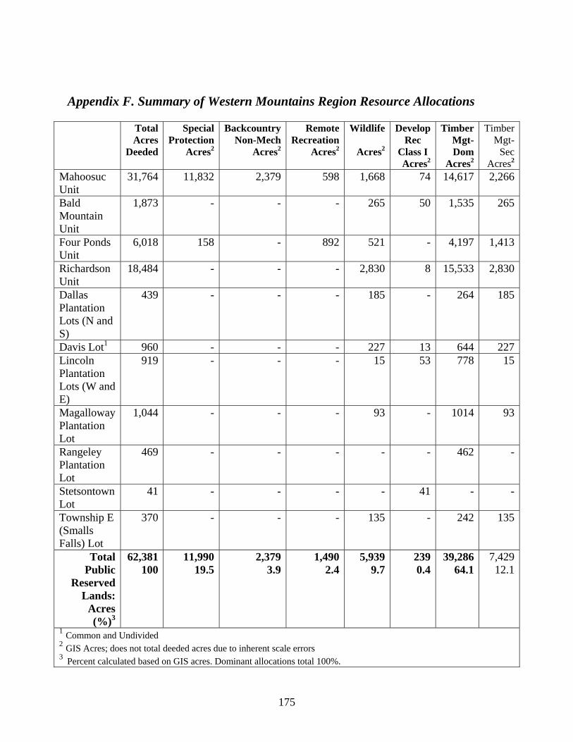
175
Appendix F. Summary of Western Mountains Region Resource Allocations
Total Acres
Deeded
Special Protection
Acres2
BackcountryNon-Mech
Acres2
RemoteRecreation
Acres2
Wildlife
Acres2
Develop Rec
Class I Acres2
TimberMgt-Dom
Acres2
Timber Mgt-
Sec Acres2
Mahoosuc Unit
31,764 11,832 2,379 598 1,668 74 14,617 2,266
Bald Mountain Unit
1,873 - - - 265 50 1,535 265
Four Ponds Unit
6,018 158 - 892 521 - 4,197 1,413
Richardson Unit
18,484 - - - 2,830 8 15,533 2,830
Dallas Plantation Lots (N and S)
439 - - - 185 - 264 185
Davis Lot1 960 - - - 227 13 644 227Lincoln Plantation Lots (W and E)
919 - - - 15 53 778 15
Magalloway Plantation Lot
1,044 - - - 93 - 1014 93
Rangeley Plantation Lot
469 - - - - - 462 -
Stetsontown Lot
41 - - - - 41 - -
Township E (Smalls Falls) Lot
370 - - - 135 - 242 135
Total Public
Reserved Lands:
Acres (%)3
62,381 100
11,990 19.5
2,3793.9
1,4902.4
5,9399.7
239 0.4
39,28664.1
7,42912.1
1 Common and Undivided 2 GIS Acres; does not total deeded acres due to inherent scale errors 3 Percent calculated based on GIS acres. Dominant allocations total 100%.