valério augusto soares de medeiros universidade de ...longpapers\029 - medeiros... · average...
TRANSCRIPT

Proceedings, 6th International Space Syntax Symposium, İstanbul, 2007
STRUCTURE AND SIZE: Brazilian cities in an urban configurational world scenario
029 Valério Augusto Soares de Medeiros Universidade de Brasília Frederico Rosa Borges de Holanda Universidade de Brasília
Abstract This paper investigates comparatively, Brazilian cities in a world scenario. It aims at exploring configurational features in urban layouts in order to identify whether or not there is a typical Brazilian city. The sample consists of 164 axial maps: 44 of them are from Brazil; 78 are international maps available at SSL; 33 were obtained from researchers around the world and 11 were drawn from urban raster images. Space syntax tools and geoprocessing techniques have been applied. The research has been fostered by the questions: (1) are Brazilian cities similar to other urban settlement groups around the world taking a configurational approach into account? And (2) based on configuration, is it possible to identify a type or a typical Brazilian city? When all variables and results were plot in a single table, some issues came up: the majority of coincidences were found among Brazilian cities and European ones in relation to average values such as Rn, Rr, Connectivity, Mean Depth (axial and segment map); strong association was found between Brazilian and Asian Pacific cities, including number of axes and segments, Rn/maximum, Rn/minimum, Mean Depth (maximum and minimum) and Mean Depth/maximum for segment maps. Findings indicate that Brazilian cities are similar to European ones in the sense of structure, for similarities are related to average figures, showing a parallel in the way the urban grid is connected. Rio de Janeiro and Lisbon, or Ouro Preto and Óbidos axial maps clearly display Portuguese ways of establishing settlements according to the geographical features of the site. Simultaneously, there is a positive association among Brazilian cities and Asian Pacific settlements, but in the sense of size, because of correspondences regarding maximum and minimum values. Brazilian contemporary cities are as big as Asian Pacific metropolis, tending, in both cases, to growing labyrinthine patterns: São Paulo and Tokyo are on the top ten in the list of the biggest cities in the world. Future developments may lead to a refined picture including extra variables and the inclusion of new cities in a robust urban databank.
Foreword and Framework Cities, as social artefacts, are built by distinct agents of synchronised action and their interpretation depends on the committed reader’s view, may it be economical, political, cultural and others. The coming out of the word ‘urbanism’ at the end of the 19th century, as a result of catalysed processes originated from the Industrial Revolution,
Keywords: Space syntax Urban analysis Form-space Comparative urban study
Valério Augusto Soares de Medeiros Universidade de Brasília, SQN 406, Bloco I, Apto. 202, Asa Norte, Brasília – DF, Brasil CEP 70847-090 +55 (0) 61 349-6798 [email protected] Frederico Rosa Borges de Holanda Faculdade de Arquitetura e Urbanismo, Programa de Pesquisa e Pós-Graduação em Arquitetura e Urbanismo, Universidade de Brasília – Caixa Postal 04431, CEP: 70919-970 Fax: (+55) (61) 3274 - 5444 Phone: (+55) (61) 3307- 2454 [email protected]

Medeiros, Holanda; Structure and Size: BrazilianCities in an Urban Configurational World Scenario
Proceedings, 6th International Space Syntax Symposium, İstanbul, 2007
029-02
promoted the attempt to apply scientific knowledge to what was believed to be cities in transformation. The field would vary from a geographic approach to a sustainable interpretation, nowadays providing several perspectives: aesthetic, historic, anthropological, etc.
The architect and the urban designer, attracted by the thinking of ‘the city’, found themselves merging into other areas of knowledge, and the product of his/her understanding, almost always, searched for help in other areas, not as a complement-mean but as a support-end of his/her attempts. He/she has thus turned more into an archaeologist than an architect and by extension, more into an administrator than an urban designer. The city has been seen through a variety of lenses, and we have moved little beyond historiographic/sociologic narratives or the description of physical and spatial characteristics. This is far from saying that such discourse or categorisations are inappropriate. On the contrary, there is simply an analytical gap that might otherwise contribute to the interpretation of what is said to be a city.
This study explores the hiatus and investigates in a specific manner the way the reading of the form-space of a city can contribute to reflexive actions about urban configuration. The expression ‘form-space’ comes from Holanda (2006) and it refers to the study of the urban fulls and voids, and their relations; the author relies on Evaldo Coutinho’s (1998) concept, as he interprets architecture in its means-components (fulls, solids, masses: the form) and end-components (voids, emptiness in-between solids: the space).
The research is thus conducted through morphological analysis, aiming at going beyond traditional descriptive approaches and unfolding attributes which emerge from the relationship among the parts of the whole urban order. The focus is on the examination of the relational aspects and on the understanding of how the different arrangements between open and closed spaces imply distinct spatial types. Brazilian city configuration is assessed in relation to the urban settlements in the world by taking into account its hierarchical structure, which is a distinct in terms of permeability, that is, the topological accessibility degree on the variety of open spaces that integrate an urban settlement.
The reading is guided by theoretical, methodological and technical space syntax analytical support. The perspective is subjected to the axial map representation, considering the exam of configurational aspects in cities in Brazil and in the world, through the following analytical categories: number of axes, number of segments, ratio segments/axes, loss of lines, connectivity, mean depth – axial and segment, integration Rn, integration Rn Basis 100, synergy and intelligibility.
It was intended to answer whether there were configurational differences among Brazilian cities and other cities in the world and to identify which differences they would be, leading to a possible identification of the existence of a typical Brazilian city or otherwise.
Sample and Procedures The undertaking of the research implied the development of configurational comparison among diverse world urban settlements.
As for the globe division and discrimination of cities, the UNESCO regional differentiation was adopted, as it contemplates simultaneously geographic and cultural criteria. Countries and their cities were grouped into six major divisions: Latin America and Caribbean/LAT; North America/NOR; Europe/EUR; Asian Pacific/ASP; Arab States/ARA and Africa/AFR. We have started from the idea that such initial discrimination was useful for it might reveal typical form-

Medeiros, Holanda; Structure and Size: BrazilianCities in an Urban Configurational World Scenario
Proceedings, 6th International Space Syntax Symposium, İstanbul, 2007
029-03
space attributes produced by cultural, social and economic aspects (this has proved so).
However, some changes were needed. Owing to the lack of axial maps for the
African cities, the AFR division was disconsidered. In order to evaluate the situation for the cities in Brazil/BRA, the country was detached from the Latin America and Caribbean group. The urban settlements of Portugal/POR were also separated from the European group, as a contraposition of the contemporary urban Portuguese artefacts was needed in order to contrast them with those from ancient Lusitanian America (Brazil), bearing in mind the well known common matrix of the form-space of these cities.
Regarding statistical procedures, a non–probabilistic sample was used, of an unintentional type, exclusively. It means that the choice of the pattern was related to convenience and availability of cartographic bases. The resulting sample, composed of 164 settlements, aggregated: 44 Brazilian cities, selected according to demographic and cultural heritage criteria (Medeiros, 2006a); 76 axial maps which are present in the urban database at the Space Syntax Laboratory in London (Medeiros et al., 2006); 33 maps, sent on request, by researchers from different universities in the world who integrate the Spatial Syntax research mailbase (Medeiros, 2006c); and 11 maps produced from cartographic basis in raster format obtained on the internet.
Statistical evaluation was based on measures of central tendency (mean and median), Pearson’s “r” and the coefficient of determination (R2), qualitatively assessed according to the Cohen Scale (Hopkins 2006). The database thus created – including the cartography, the linear representations and the analysed axial maps – was inserted on the Arcview 9,1® software, which is a geoprocessing software that brings together in the same information databank vectorials (maps) and other different data, optimising the information treatment.
World Cities: A Panel Distribution The spatial characterisation of the cities of the sample has enabled some considerations: the 164 cities are distributed in an irregular manner in the research regions (Figure 1). It is the outcome of the collecting process of the axial maps and the dependency on permission to use the information. Areas with major or minor concentration of researchers dedicated to the procedure are revealed.
The predominance of examples is in Europe (54 examples correspond to 33% of the sample): space syntax theory was created there and the greater part of its first studies have concerned cities of the continent and, especially, of the United Kingdom (33% of European cities are in England).
The second larger group is represented by the Brazilian cities, with 44 settlements that represent 27% of the sample. The rates indicate the contribution of this research in the consolidation of the urban database. The sample of other Asian Pacific cities are in the third position, comprising 20% of the sample, on which there is a great concentration of Iranian examples (38%), as a result of the tradition of a country where researches are focused on the configurational analysis (Cf. Karimi 1997; Azimzadeh & Bjur 2005; Nejad 2005). The other regions present a smaller number of urban centres: North American settlements correspond exclusively to the American cities, the majority of which have derived from studies by Major (1997), a total of 16 cities

Medeiros, Holanda; Structure and Size: BrazilianCities in an Urban Configurational World Scenario
Proceedings, 6th International Space Syntax Symposium, İstanbul, 2007
029-04
(10% of all cities investigated). There are only 5 Arab cities (3%) and they include Middle East and North Africa (Cairo). Latin-American examples are only three (excluding Brazilian cities). Despite the small percentage (2%), the capital cities (Quito, Santiago do Chile and Mexico City) are representative of the strongly regulated manner by which the urban centre foundation was established by the Spaniards in their Vice Reigns in America, justifying, in this sense, the maintenance of this group.
If the sample is grouped per country, we find, from smaller to greater percentages: Germany (3%), Greece (3%), Holland (5%), Portugal (6%), China (7%), Iran (7%), USA (10%), United Kingdom (11%) and Brazil (27%). Besides the clear predominance of Brazilian examples, which indicates a robust primary database elaboration, these nine countries are responsible for 79% of the sample, whereas the other 25 nations reach only 21%, indicating a strong polarisation.
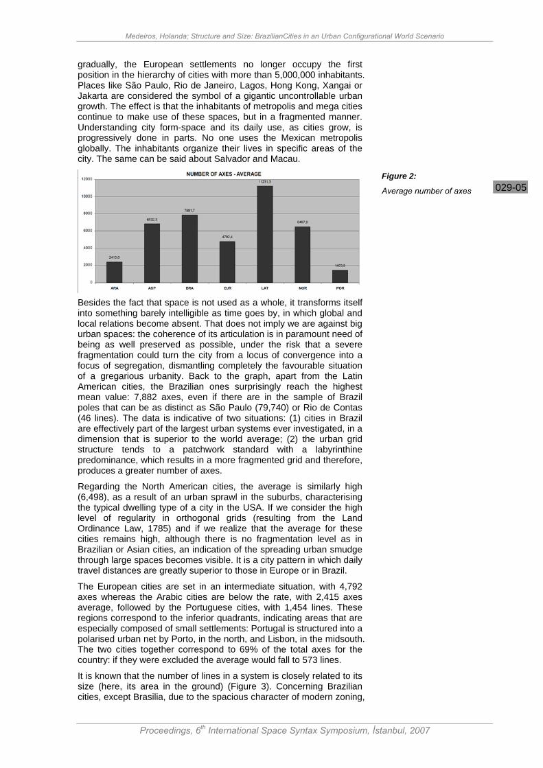
Number of Axes Settlements were evaluated considering the average number of axes per axial map: the analysis of picture 2 discusses the findings. There is a distortion to Latin American cities: as there are just three examples and Santiago is one of the greatest linear representations ever produced for the continent, with 28,623 lines, the average considerably raises. Global average reaches 5,872 lines: on the top of the list we find Brazilian, Asian and American cities. Among the fourteenth largest cities, the ones containing axes that are superior to 20,000 lines (9% of the sample), eleven (79%) can be found in these regions of the world (Goiânia/20,166; Seattle/20,208; Beijing/20,505; Kyoto/22,002; Manaus/23,191; Johor Bahru/24,721; Santiago/28,623; Chicago/30,534; Salvador/45,349; Tokyo/73,719 and São Paulo/79,740). The exceptions were Istanbul/21,783; Athens/23,517 and Gothenburg/32,144, all in Europe.
The high average rates originate from the fact that in these regions the largest agglomerations of contemporary urban world can be found. The process of transformation of great city centres in metropolis and mega cities, through an apparent endless conurbation, affects, nowadays, especially the cities of poor or underdeveloped countries:
Figure 1:
Distribution and percentage of the cities of the sample based on the regions of the world
Medeiros, Holanda; Structure and Size: BrazilianCities in an Urban Configurational World Scenario
Proceedings, 6th International Space Syntax Symposium, İstanbul, 2007
029-05
gradually, the European settlements no longer occupy the first position in the hierarchy of cities with more than 5,000,000 inhabitants. Places like São Paulo, Rio de Janeiro, Lagos, Hong Kong, Xangai or Jakarta are considered the symbol of a gigantic uncontrollable urban growth. The effect is that the inhabitants of metropolis and mega cities continue to make use of these spaces, but in a fragmented manner. Understanding city form-space and its daily use, as cities grow, is progressively done in parts. No one uses the Mexican metropolis globally. The inhabitants organize their lives in specific areas of the city. The same can be said about Salvador and Macau.
Besides the fact that space is not used as a whole, it transforms itself into something barely intelligible as time goes by, in which global and local relations become absent. That does not imply we are against big urban spaces: the coherence of its articulation is in paramount need of being as well preserved as possible, under the risk that a severe fragmentation could turn the city from a locus of convergence into a focus of segregation, dismantling completely the favourable situation of a gregarious urbanity. Back to the graph, apart from the Latin American cities, the Brazilian ones surprisingly reach the highest mean value: 7,882 axes, even if there are in the sample of Brazil poles that can be as distinct as São Paulo (79,740) or Rio de Contas (46 lines). The data is indicative of two situations: (1) cities in Brazil are effectively part of the largest urban systems ever investigated, in a dimension that is superior to the world average; (2) the urban grid structure tends to a patchwork standard with a labyrinthine predominance, which results in a more fragmented grid and therefore, produces a greater number of axes.
Regarding the North American cities, the average is similarly high (6,498), as a result of an urban sprawl in the suburbs, characterising the typical dwelling type of a city in the USA. If we consider the high level of regularity in orthogonal grids (resulting from the Land Ordinance Law, 1785) and if we realize that the average for these cities remains high, although there is no fragmentation level as in Brazilian or Asian cities, an indication of the spreading urban smudge through large spaces becomes visible. It is a city pattern in which daily travel distances are greatly superior to those in Europe or in Brazil.
The European cities are set in an intermediate situation, with 4,792 axes whereas the Arabic cities are below the rate, with 2,415 axes average, followed by the Portuguese cities, with 1,454 lines. These regions correspond to the inferior quadrants, indicating areas that are especially composed of small settlements: Portugal is structured into a polarised urban net by Porto, in the north, and Lisbon, in the midsouth. The two cities together correspond to 69% of the total axes for the country: if they were excluded the average would fall to 573 lines.
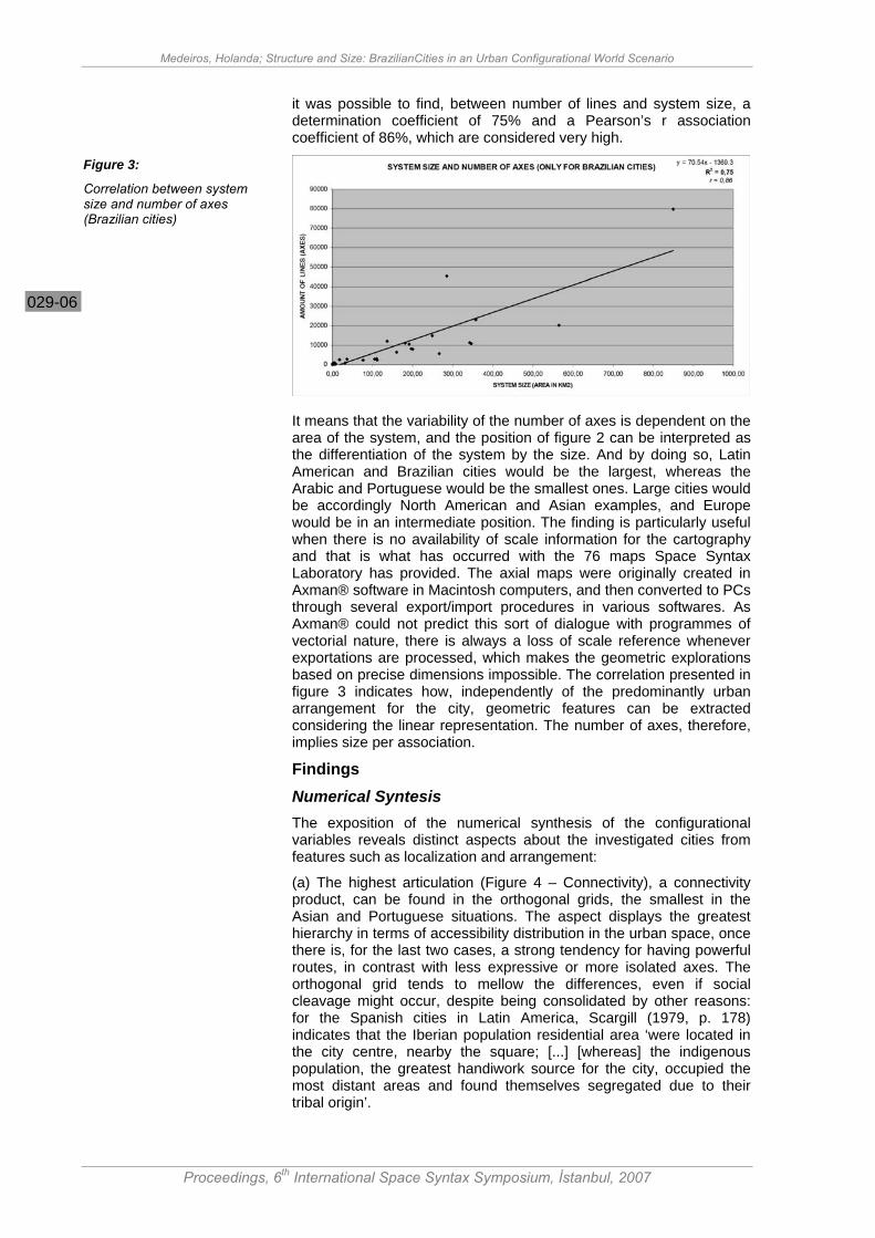
It is known that the number of lines in a system is closely related to its size (here, its area in the ground) (Figure 3). Concerning Brazilian cities, except Brasilia, due to the spacious character of modern zoning,
Figure 2:
Average number of axes
Medeiros, Holanda; Structure and Size: BrazilianCities in an Urban Configurational World Scenario
Proceedings, 6th International Space Syntax Symposium, İstanbul, 2007
029-06
it was possible to find, between number of lines and system size, a determination coefficient of 75% and a Pearson’s r association coefficient of 86%, which are considered very high.
It means that the variability of the number of axes is dependent on the area of the system, and the position of figure 2 can be interpreted as the differentiation of the system by the size. And by doing so, Latin American and Brazilian cities would be the largest, whereas the Arabic and Portuguese would be the smallest ones. Large cities would be accordingly North American and Asian examples, and Europe would be in an intermediate position. The finding is particularly useful when there is no availability of scale information for the cartography and that is what has occurred with the 76 maps Space Syntax Laboratory has provided. The axial maps were originally created in Axman® software in Macintosh computers, and then converted to PCs through several export/import procedures in various softwares. As Axman® could not predict this sort of dialogue with programmes of vectorial nature, there is always a loss of scale reference whenever exportations are processed, which makes the geometric explorations based on precise dimensions impossible. The correlation presented in figure 3 indicates how, independently of the predominantly urban arrangement for the city, geometric features can be extracted considering the linear representation. The number of axes, therefore, implies size per association.
Findings Numerical Syntesis The exposition of the numerical synthesis of the configurational variables reveals distinct aspects about the investigated cities from features such as localization and arrangement:
(a) The highest articulation (Figure 4 – Connectivity), a connectivity product, can be found in the orthogonal grids, the smallest in the Asian and Portuguese situations. The aspect displays the greatest hierarchy in terms of accessibility distribution in the urban space, once there is, for the last two cases, a strong tendency for having powerful routes, in contrast with less expressive or more isolated axes. The orthogonal grid tends to mellow the differences, even if social cleavage might occur, despite being consolidated by other reasons: for the Spanish cities in Latin America, Scargill (1979, p. 178) indicates that the Iberian population residential area ‘were located in the city centre, nearby the square; [...] [whereas] the indigenous population, the greatest handiwork source for the city, occupied the most distant areas and found themselves segregated due to their tribal origin’.
Figure 3:
Correlation between system size and number of axes (Brazilian cities)

Medeiros, Holanda; Structure and Size: BrazilianCities in an Urban Configurational World Scenario
Proceedings, 6th International Space Syntax Symposium, İstanbul, 2007
029-07
(b) Concerning depth, there is a polarization (Figure 4 – Mean Depth). The shallower the systems, the more orthogonal they are, although the deepest are the largest ones, composed by a set of grids, like the Brazilian, Asian and European cities. As the Portuguese cities are smaller (Figure 3), they present the mean and maximum depths reduced as we have here a combination of geometric and topologic characteristics: cities having the same size present depths markedly distinct, like Latin American and Brazilian examples; grid articulation forms a striking feature.
(c) As for the integration findings (Figure 4 – Integration), the most integrated systems are the orthogonal ones (Latin America and United States) or the small organic ones (Portugal), whilst the Brazilian cities occupy the bottom pole in all situations (mean, maximum and minimum values), bringing about the argument over the patchwork standard implication regarding big urban structures.
In relation to synergy, the bigger the system is, the smaller the value is. If all the systems with line numbers above 20,000 are excluded (14 out of 164 belonging to the sample), we will obtain a R2 of 22% and a Person’s r of 0,47, interpreted as moderated. There are, however, other determining factors leading to the definition of synergy more than the number of axes associated to the size of the system. It is supposed that the articulating configurational aspects of the urban grid
Figure 4:
Connectivity, Mean Depth and Integration
Medeiros, Holanda; Structure and Size: BrazilianCities in an Urban Configurational World Scenario
Proceedings, 6th International Space Syntax Symposium, İstanbul, 2007
029-08
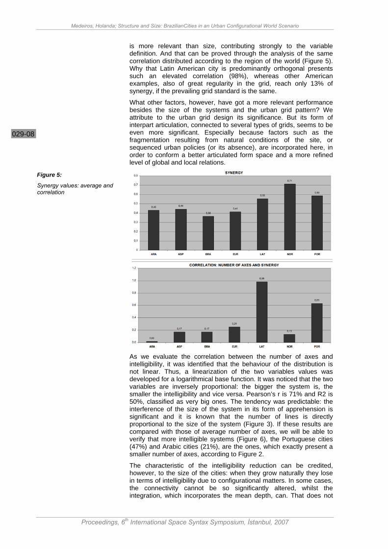
is more relevant than size, contributing strongly to the variable definition. And that can be proved through the analysis of the same correlation distributed according to the region of the world (Figure 5). Why that Latin American city is predominantly orthogonal presents such an elevated correlation (98%), whereas other American examples, also of great regularity in the grid, reach only 13% of synergy, if the prevailing grid standard is the same.
What other factors, however, have got a more relevant performance besides the size of the systems and the urban grid pattern? We attribute to the urban grid design its significance. But its form of interpart articulation, connected to several types of grids, seems to be even more significant. Especially because factors such as the fragmentation resulting from natural conditions of the site, or sequenced urban policies (or its absence), are incorporated here, in order to conform a better articulated form space and a more refined level of global and local relations.
As we evaluate the correlation between the number of axes and intelligibility, it was identified that the behaviour of the distribution is not linear. Thus, a linearization of the two variables values was developed for a logarithmical base function. It was noticed that the two variables are inversely proportional: the bigger the system is, the smaller the intelligibility and vice versa. Pearson’s r is 71% and R2 is 50%, classified as very big ones. The tendency was predictable: the interference of the size of the system in its form of apprehension is significant and it is known that the number of lines is directly proportional to the size of the system (Figure 3). If these results are compared with those of average number of axes, we will be able to verify that more intelligible systems (Figure 6), the Portuguese cities (47%) and Arabic cities (21%), are the ones, which exactly present a smaller number of axes, according to Figure 2.
The characteristic of the intelligibility reduction can be credited, however, to the size of the cities: when they grow naturally they lose in terms of intelligibility due to configurational matters. In some cases, the connectivity cannot be so significantly altered, whilst the integration, which incorporates the mean depth, can. That does not
Figure 5:
Synergy values: average and correlation

Medeiros, Holanda; Structure and Size: BrazilianCities in an Urban Configurational World Scenario
Proceedings, 6th International Space Syntax Symposium, İstanbul, 2007
029-09
imply the need to alter the structure of a large city, by using a proportion of big globalising axes in order to improve its intelligibility. There is no possible configurational adjustment in such cases. Besides that, any sort of interference in this sense would bring positive changes in theoretical terms, since the inhabitants would continue empirically to experiment, notice, understand and make daily use of the settlement in parts. In cases like this, everyday life is organized in fragments, not globally.
Graphical Synthesis The distribution of all values for each variable is presented, according to world region, in grey scale. By borrowing the spirit of the grey scale from an axial map, where the darker the element, the higher its value, and the lighter the elements, the lower its value, we find the result of Table 1
The scale was inverted in relation to the depth variables (mean, maximum and minimum, in the axial and segmental maps) and the loss of conversion lines, as they are inversely proportional to a major integration. The deeper, the lighter the zone is, the shallower the system, the darker the zone is. The analysis of the Figure reveals some chromatic predominance:
(a) Latin American and American cities concentrate the larger number of dark zones where the most permeable patterns are found in the whole sample; (b) Arab cities are placed in an intermediate position; (c) Asian and European cities, and somehow Brazilian ones, present a predominance of light zones, suggesting they form a group; and yet there is a difference: Asian cities are more accessible, European cities are in an intermediate level, Brazilian ones are less accessible than the other two sets; (d) Although Portuguese cities present light extreme zones in the geometric field, by being the smallest set, they contain several dark medium variables, indicating positive aspects concerning configuration, especially in relation to the synergy and intelligibility (black);
Figure 6:
Intelligibility values: average and correlation

Medeiros, Holanda; Structure and Size: BrazilianCities in an Urban Configurational World Scenario
Proceedings, 6th International Space Syntax Symposium, İstanbul, 2007
029-10
(e) Brazilian cities undeniably concentrate the highest part of the more reduced values, mainly in a topologic sense (predominance of light grey events). Out of 17 situations in this colour, nine are in Brazil, which corresponds to 53% of the total.
ARA ASP BRA EUR LAT NOR POR GEOMETRY Number of Axes - Number of Segments - Ratio Segments/Axes - Loss of Lines - TOPOLOGY – AVERAGES Connectivity Mean Mean Depth Mean Mean Depth (Segments) Mean Integration Rn Mean Integration Rn Basis 100 Mean Synergy - Intelligibility - TOPOLOGY- POLES Connectivity Maximum Mean Depth Maximum Mean Depth (Segments) Maximum Mean Depth (Segments) Minimum Integration Rn Maximum Integration Rn Minimum
Once the proximity between Brazilian and Asian cities was identified, the table seen in Table 2 produced. On the graph, it is possible to identify, for each variable, what other group of cities in the world present similar values to those of Brazil. If the value for a Brazilian city was on the top of the graphic, the immediately inferior would be considered; if it were on the bottom the immediately superior would be identified. For an intermediate position, the values closer to the top or the bottom were considered, depending on the proximity level.
ARA ASP EUR LAT NOR POR GEOMETRY Number of Axes - Number of Segments - Ratio Segments/Axes - Loss of Lines - TOPOLOGY – AVERAGES Connectivity Mean Mean Depth Mean Mean Depth (Segments) Mean Integration Rn Mean Integration Rn Basis 100 Mean Synergy - Intelligibility - TOPOLOGY- POLES Connectivity Maximum Mean Depth Maximum Mean Depth (Segments) Maximum Mean Depth (Segments) Minimum Integration Rn Maximum Integration Rn Minimum
Through graphic observation it is possible to notice that there is a greater correspondence between Brazilian and Asian cities when there is a geometric reference in the category, what can be associated to the size of the axial map. Regarding topological extremes, there are four, out of six options, in correspondence with Asian cities. On the other hand, the predominant coincidence between Brazilian cities and
Table 1:
Configurational measures synthesis
Table 2:
Correspondence of values among world regions

Medeiros, Holanda; Structure and Size: BrazilianCities in an Urban Configurational World Scenario
Proceedings, 6th International Space Syntax Symposium, İstanbul, 2007
029-11
the European ones can be found in the values of topological medians (four out of six possible ones), or in those which refer to geometry, although more connected to the manner of articulation of the urban grid than to the size itself of the systems, as a reason of segments per axes or loss in the length of the lines.
Based on that, it is possible to conclude that the Brazilian cities are similar to the Asian ones in terms of size (geometry), and more similar to the European cities concerning resulting form-spaced configuration. The articulation of the urban grid by being derived from a specific European matrix, finds more proximity with patterns from there: arrangements and forms of connection alike produce a space of common topologic accessibility. It is also interesting to observe the distance found between Brazilian and Portuguese cities. For the Brazilian sample as a whole, there are few relations with the Portuguese settlements (only in maximum integration, medium integration Base 100 and connectivity) however, the Portuguese measures coincide with those of cities of small scale and of cultural heritage importance in Brazil (Cf. Medeiros & Holanda 2005, Medeiros, 2006), an indication that such cities keep the Portuguese savoir faire in America.
Therefore, the inheritage exists, but it can only be found in those settlements of the same scale or dimension. As Brazilian cities grew large, there was a rupture in topologic attributes, which progressively set the performance of the two urban groups apart at distinct sides of the Atlantic Ocean. The previous paragraphs conduct, thus, to an answer for one of the research questions: are the Brazilian cities similar to other urban settlements around the world, under this configurational perspective?
Yes.
It is left for us to ask the second question: based on the configuration, is it possible to identify the kind of, or a typical, Brazilian city?
It is known that Brazilian cities do get closer to European and Asian settlements, but no wonder they comprehend a more segregated grouping, badly articulated, less synergetic and intelligible than the other two groups. There is no other world region with the same characteristics in the same level.
Totally aware that natural movement ‘is based on appropriate levels of intelligibility’, we can argue that the complex environments originated from confusing drawings promote conditions of low intelligibility, which contribute to the difficulty in apprehension (Raford & Hillier 2005, p. 573), which is particularly the case for great urban structures, like the big cities from Brazil, constituted by numerous suburban spots, with old city centers that are no longer representative of the city as a whole. Things get worse when it comes to states of social segregation and derivatives: distance between rich and the poor, difficulty in locomotion, income concentration, low productivity, etc. Brazilian cities are a precise type of urban form-space, produced by a special historical urban process that bequeathed to the contemporary city an unprecedented spatial fragmentation.
Acknowledgements; CAPES, Câmara dos Deputados, Universidade de Brasília/UnB.
Axial maps are to be credited as follows: Adriana Nogueira (Aracaju), Ana Barros (Belém, Braga, Coimbra, Évora, Faro, Fátima, Funchal, Macau, Óbidos, Ourém, Porto and Quito), Anirban Adhya (Ann Arbor), Api Kasemsook (Phuket), Camélia Ksumo (Delft, Leiden), Claudia Ortiz (Ciudad de Mexico), Décio Rigatti (Porto Alegre), DIMPU/UnB Research Group (Maceió, Vitória e Brasília), Edja Trigueiro (Teresina), Erica Calogero (Venezia), Fusun Erkul (Samsun), Guilherme Varela and Lucas

Medeiros, Holanda; Structure and Size: BrazilianCities in an Urban Configurational World Scenario
Proceedings, 6th International Space Syntax Symposium, İstanbul, 2007
029-12
Figueiredo (Recife), Kavyan Karimi (Hamedan, Bristol, York), Konstantinos Kypris (Nicósia), Lars Marcus (Estocolmo/Stockholm), Laurie Neale (Haia/The Hague), Leila Alarcón (Goiânia), Loon Wai (Johor Bahru and Penang Island), Margarita Greene and Rodrigo Mora (Santiago), Mark Major (Atlanta, Chicago), Maurício Polidrolli (Pelotas), Mir Azimzadeh (Adaban, Gotemburgo - Gotemburg, Kerman, Nain, Rasht, Semnan, Shiraz and Yadz), MUsA/UFRN Research Group (Natal), Polly Fong (Manchester), Reza Nejad (Dezful), Romppanen Mervi (Helsinque/Helsinki), Shinichi Iida (Tokyo), Tao Yung (Pequim/Beijing), Teresa Heitor (Lisboa/Lisbon), Valentina Karvounzi (Atenas/Athens), Waffa Al-Ghatam (Muharraq and Manama), Xu Jianming (Amsterdã/Amsterdam), Ye Arlem (Chegkan, Hongcun, Nanping, Pingshan, Tangmo, Xidi, Yuliang and Zhanqi) and Yvonne Maha (Anápolis).
Cartographic bases were obtained from: Ana Queiroz (Palmas), Graciete Costa (Manaus), Iana Rufino (João Pessoa), Luciana Travassos (São Paulo), Mabel Zambuzzi (Salvador), Marcus Pereira (Fortaleza), Patrícia Trinta (São Luís), Ricardo Castor (Cuiabá), Thamara Reis (Uberlândia) and IPHAN (maps for historical Brazilian cities).
Axial maps which were not listed above belong to the Space Syntax Laboratory/UCL urban database (Thanks to Professor Bill Hillier who made the maps available).
References Azimzadeh, M., Bjur, H., 2005, “Transforming Cities”, A. van Nes (Ed.), Proceedings, 5th International Space Syntax Symposium, Delft University of Technology. Delft, v. 1, pp. 295-308.
Coutinho, E., 1998, “O Espaça Da Arquitetura”, Perspectiva, São Paulo.
Holanda, F., 2006, “Arquitetura sociológica”, mimeo.
Hopkins, W., 2006, “A New View of Statistics”, viewed 29 May 2006, < http://sportsci.org/resource/ stats/effectmag.html >.
Karimi, K., 1997, ”The Spatial Logic of Organic Cities in Iran and the United Kingdom”, Proceedings, 1st International Space Syntax Symposium, SSL/UCL, London, v. 1, pp. 06.1-06.17.
Major, M., 1997, “Are American Cities Different?”, Proceedings, 1st International Space Syntax Symposium, SSL/UCL, London, v.3, pp.09.1-09.14.
Medeiros, V., Holanda, F., 2005, “Urbis Brasiliae”, A. van Nes (Ed.), Proceedings, 5th International Space Syntax Symposium, Delft University of Technology. Delft, v. 1, pp. 331-339.
Medeiros, V., (Ed.), 2006a, “Brazilian Urban Form Database”, DIMPU, Research Group, Universidade de Brasilia, Brasilia.
Medeiros, V., 2006b, “Urbis Brasilis ou Sobre Cidades do Brasil”, DSc thesis, Universidade de Brasília, Brasília.
Medeiros, V., (Ed.), 2006c, “World Urban Form Database”, DIMPU Research
Group, Universidade de Brasilia, Brasília.
Medeiros, V., Hillier, B., Figueiredo, L., (Eds.), 2006, “Space Syntax Laboratory Urban Form Database”, Bartlett School of Graduate Studies, University College London, London.
Nejad, R., 2005, “Social Bazaar and Commercial Bazaar?” A. van Nes (Ed.), Proceedings, 5th International Space Syntax Symposium, Delft University of Technology. Delft, v. 1, pp. 187-200.
Raford, N, Hillier, B., 2005, “Correlation Landscapes”, A. van Nes (Ed.), Proceedings, 5th International Space Syntax Symposium, Delft University of Technology. Delft, v. 1, pp. 573-585.
Scargill, D., 1979, The Form of Cities, Bell & Hyman, London.