valley line west lrt mackinnon ravine and groat ravine ... · 2.2 mackinnon ravine project scope...
TRANSCRIPT
Site Location Study
Pursuant to Bylaw 7188
for
Valley Line-West Light Rail Transit (LRT)
Crossing at Groat Ravine
and
Activities Near MacKinnon Ravine
Final Report
Prepared for:
LRT Delivery
Integrated Infrastructure Services
Edmonton, Alberta
Prepared by:
Spencer Environmental
Management Services Ltd.
Edmonton, Alberta
Under contract to:
AECOM
Edmonton, Alberta
Project Number EP-715
September 2018
Spencer Environmental
September 2018 Site Location Study for VL-W Page i
Groat and MacKinnon Ravines
EXECUTIVE SUMMARY
Much of the VL-W alignment follows existing Stony Plain Road (SPR). At two SPR
locations the alignment traverses or is adjacent to a natural ravine that forms part of the
North Saskatchewan River Valley Area Redevelopment Plan (NSRV ARP) (Bylaw 7188):
SPR over Groat Ravine; and, SPR between 147 Street and 149 Street north of MacKinnon
Ravine. Pursuant to the NSRV ARP, each of these VL-W intersections with Bylaw 7188
lands triggers the need for a Site Location Study (SLS), this document, and an
Environmental Impact Assessment (EIA) for the intersecting proposed project
components. Separate EIAs have been prepared as companion documents to this SLS.
The Groat Ravine crossing involves replacement of the existing SPR bridge with a wider
bridge that will accommodate LRT infrastructure. The VL-W Reference Design shows the
bridge type as a Single Span Steel Haunched Girder Bridge. New infrastructure to be
located within the ravine will be limited to bridge abutments and one area of fill on the
upper east ravine slope, to support the widened roadway and new sidewalk, held in place
by an MSE wall. Approximately half of the retaining wall and associated fill will be
situated within the bylaw boundary, the remainder will extend back into some parcels that
have been acquired for this by the City.
Addition of LRT north of MacKinnon Ravine requires a localized widening of the roadway
to the south, subsequent widening of the south sidewalk, and some transit infrastructure
adjustment. A short retaining structure will be required. In this case, all proposed new
infrastructure will be located inside the existing ROW except a short segment of sidewalk,
to the east of the bus turnaround, but the sidewalk is not located within the ravine proper.
However, some of this construction requires a temporary work area beyond the existing
road ROW and into the upper margin of MacKinnon Ravine. In addition, the north end of
an existing pedestrian bridge that crosses the ravine at this location must be modified
slightly to tie into the new sidewalk. The existing bus turnaround, fully situated within the
existing roadway ROW, will be decommissioned and replaced with a new bus bay and
sidewalk; excess lands will be reclaimed to a natural plant community.
Alternatives to the Groat Ravine crossing and the temporary incursion into MacKinnon
Ravine were examined and found to be unsuitable. Project design at both locations found
several ways to reduce encroachment into the ravines. For example, use of retaining walls.
Unlike many recreational or utility projects proposed for river valley system lands, this
project is not dependent on a river valley location. Rather, this project happens to
intersect with bylaw lands, as part of a larger tablelands project. The VL-W is a current
City priority project and the location of the VL-W within the existing SPR ROW is
consistent with City transportation master planning. The long planning history of the
selected VL-W alignment has led to selection of an alignment that intersects with bylaw
lands. This corridor and alignment planning history, followed by more specific LRT
planning, amounts to an institutional and a social constraint that requires some permanent
and temporary encroachment in Bylaw 7188 lands.
Spencer Environmental
September 2018 Site Location Study for VL-W Page ii
Groat and MacKinnon Ravines
Table of Contents
Chapter Page
INTRODUCTION AND PROJECT LOCATION ............................................ 1
VL-W PROJECT SCOPE .................................................................................... 2
2.1 Groat Ravine Project Scope ........................................................................................... 2
2.1.1 Proposed Bridge ........................................................................................................ 2
2.1.2 Landscaping ............................................................................................................... 3
2.2 MacKinnon Ravine Project Scope ................................................................................. 3
2.2.1 Sidewalk Widening and Retaining Structure ............................................................. 3
2.2.2 Existing Pedestrian Bridge Modification ................................................................... 3
2.2.3 Decommissioning of Bus Turnaround ....................................................................... 4
2.2.4 Landscaping ............................................................................................................... 4
VL-W LOCATION ANALYSIS AND JUSTIFICATION ................................ 5
3.1 Alternative Location Review ......................................................................................... 5
3.1.1 VL-W Alignment ....................................................................................................... 5
3.1.2 Groat Ravine Crossing Alternatives .......................................................................... 5
3.1.3 MacKinnon Ravine Alternatives ............................................................................... 6
3.2 River Valley Dependencies ............................................................................................ 6
3.3 Overview of Bylaws/Plans/Policies ............................................................................... 6
CONSTRAINTS ANALYSIS GROAT RAVINE AND MACKINNON
RAVINE ............................................................................................................................. 7
4.1 Social Constraints .......................................................................................................... 7
4.2 Financial ......................................................................................................................... 7
4.3 Environmental Constraints ............................................................................................. 7
4.4 Institutional Constraints ................................................................................................. 7
CONCLUSION ..................................................................................................... 8
REFERENCES ...................................................................................................... 9
6.1 Literature Cited .............................................................................................................. 9
6.2 Personal Communications .............................................................................................. 9
APPENDIX A: FIGURES ............................................................................................ A1
Spencer Environmental
September 2018 Site Location Study for VL-W Page 1
Groat and MacKinnon Ravines
INTRODUCTION AND PROJECT LOCATION
The City of Edmonton is currently developing the Valley Line Light Rail Transit (LRT),
an urban style LRT that will connect Mill Woods Town Center to the Lewis Farms Area.
The project has been divided into two stages, Valley Line-Southeast (VL-SE) extending
from Mill Woods to downtown (102 Street) and Valley Line -West (VL-W) extending from
downtown to Lewis Farms Transit Centre. VL-SE is now under construction. In 2017, City
of Edmonton LRT Delivery retained a consortium of firms known as ConnectEd Transit
Partnership (CTP) to complete preliminary design (which had been taken to 30% in 2013)
and facilitate procurement. Spencer Environmental was retained by CTP to act as
environmental lead. With the VL-W preliminary design nearing completion, the project is
now in the procurement preparation phase. The preliminary design will serve as a
Reference Design that will be advanced and provided to the successful bidder (the
Proponent) for the next design phase. The intent is to have the VL-W procurement-ready
by autumn 2018 in anticipation of availability of higher order government funding that
could potentially facilitate construction initiation in 2019/2020.
The VL-W alignment is wholly situated in highly urban areas of the city, and much of the
alignment is within Stony Plain Road (SPR) (Figure 1). In two locations on SPR, the
alignment traverses or is adjacent to a natural ravine that forms part of the North
Saskatchewan River Valley Area Redevelopment Plan (NSRV ARP) (Bylaw 7188): SPR
over Groat Ravine; and, SPR between 147 Street and 149 Street adjacent to and north of
MacKinnon Ravine (Figure 1). Pursuant to the NSRV ARP, each proposal for the
development of a major facility that is publicly owned or is developed on public lands is
subject to a Site Location Study (SLS) detailing costs, and social, environmental and
institutional constraints that make a river valley location essential. Consultation with City
Planning indicated that each of the VL-W intersections with Bylaw 7188 lands triggers the
need for a SLS. The two project components are addressed together in this SLS. The
report format and content follow a project-specific Terms of Reference developed through
scoping discussions held between the environmental consultant, LRT Delivery and City
Planning, informed by a brief description of project activities, preliminary engineering
drawings, the project location and anticipated project activities. In addition, a separate
Environmental Impact Assessment (EIA) has been prepared for each of those two project
segments (Spencer Environmental 2018a, 2018b).
Spencer Environmental
September 2018 Site Location Study for VL-W Page 2
Groat and MacKinnon Ravines
VL-W PROJECT SCOPE
Preliminary design is complete for the entire VL-W alignment. That design, referred to as
the Reference Design, will be carried forward into the project procurement phase and
beyond to be advanced to final design by the successful Proponent. The City is currently
developing the Project Agreement (PA) that will govern Proponent scope and practices.
The VL-W alignment follows SPR from 121 Street to 156 Street. To enable LRT
integration into this existing arterial road, several locations require road reconfiguring, bus
stop adjustments, new LRT stops, new or improved sidewalks, modified intersections or
approach roads etc., and, ultimately, some local widening of the road right-of-way (ROW).
Two locations needing adjustments are the SPR crossing of Groat Ravine, and, SPR north
of and immediately adjacent to MacKinnon Ravine. The proposed project scope at each
of these two locations is described separately below.
2.1 Groat Ravine Project Scope
The Groat Ravine crossing involves replacement of the existing bridge with a wider bridge
to tie in with the wider approaching roads and accommodate two vehicle lanes, LRT
infrastructure and pedestrian walks. Retrofitting the existing bridge is not feasible. New
infrastructure to be located within the ravine is limited to a new bridge and associated
support. There are no ancillary LRT facilities required at this location. The specific project
location and design in relation to Bylaw 7188 lands is provided in Figure 2.
2.1.1 Proposed Bridge
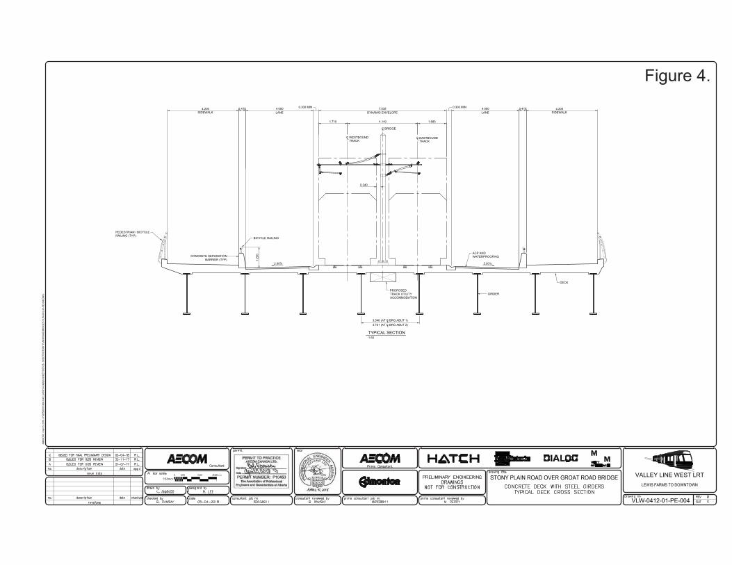
The proposed new bridge will be wider than the existing bridge (25.4 m wide compared to
18.4 m wide) (Figure 3). The vertical profile of the bridge remains the same, the horizontal
alignment will be slightly curved, with the east abutment slightly shifted to the south. The
new bridge is designed to accommodate two centre LRT tracks, two outside vehicle lanes
and two 4.2 m wide sidewalks (Figure 4). The Reference Design shows the bridge type as
a Single Span Steel Haunched Girder Bridge (Figure 3). Supporting infrastructure within
the ravine will consist of concrete abutments on piles with concrete slope protection in
front of the abutment seat that will have a slope equal to or less than the existing exposed
slopes (Figure 3). The existing Shared Use Path (SUP) in the ravine along the west side of
Groat Road, including the retaining wall forming the west boundary of that path, will be
maintained as is.
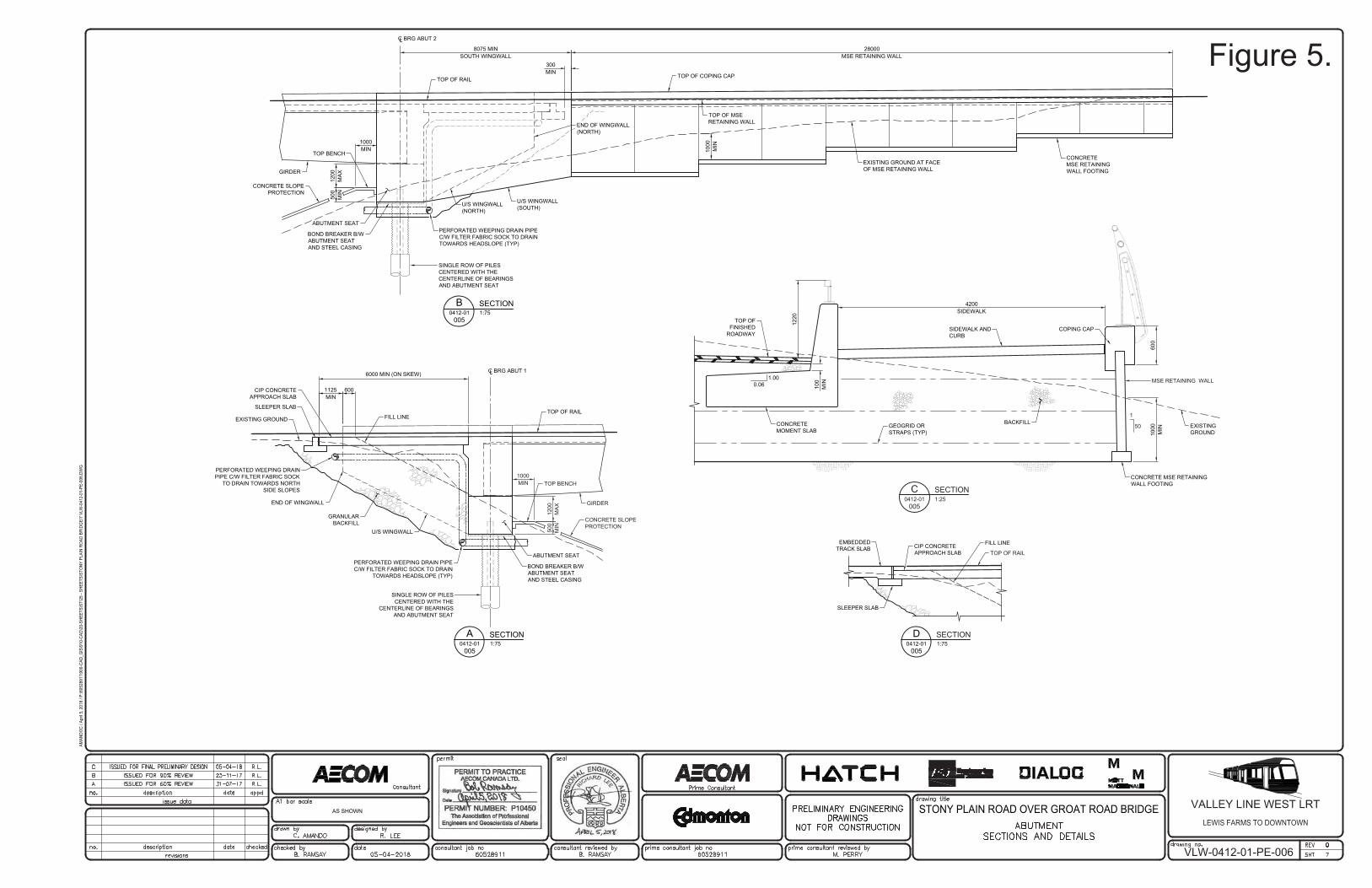
At the southeast bridge end, some fill is required on the upper ravine slope to support the
widened roadway and new sidewalk. The fill will be held in place by an estimated 28 m
long MSE wall (Figure 5). Approximately half of the MSE wall and associated fill will be
situated within the bylaw boundary, the remainder extends back from the ravine edge into
some sloped, treed parcels that have been acquired by the City.
The delineated project area (which also represents the construction limits) within and
outside of the Bylaw boundaries is shown on Figure 2.
Spencer Environmental
September 2018 Site Location Study for VL-W Page 3
Groat and MacKinnon Ravines
2.1.2 Landscaping
The Reference Design includes a preliminary (conceptual) landscape plan for the full
alignment. The landscape plan for the Groat Ravine segment (Figure 6) indicates that the
roadside approaches to the bridge will be newly landscaped and will receive some new
trees and some new shrub beds. Shrubs and trees are shown planted in front of the new
MSE wall. Within the bylaw boundaries the landscape plan shows that some areas that to
be cleared will be landscaped with “new natural areas” and “new shrub beds”. The EIA
elaborates on measures to be taken in these planned new natural areas.
2.2 MacKinnon Ravine Project Scope
The second bylaw location affected by the VL-W is between 147 Street and 149 Street,
where SPR runs immediately parallel to the steep north margin of MacKinnon Ravine
(Figure 7). Here the bylaw boundary was generously drawn in the 1980s to include much
of SPR, which is clearly outside of the ravine. It is MacKinnon Ravine that is most relevant
to the SLS. Addition of LRT infrastructure north of MacKinnon Ravine requires a
widening of the roadway to the south in this location, subsequent widening of the south
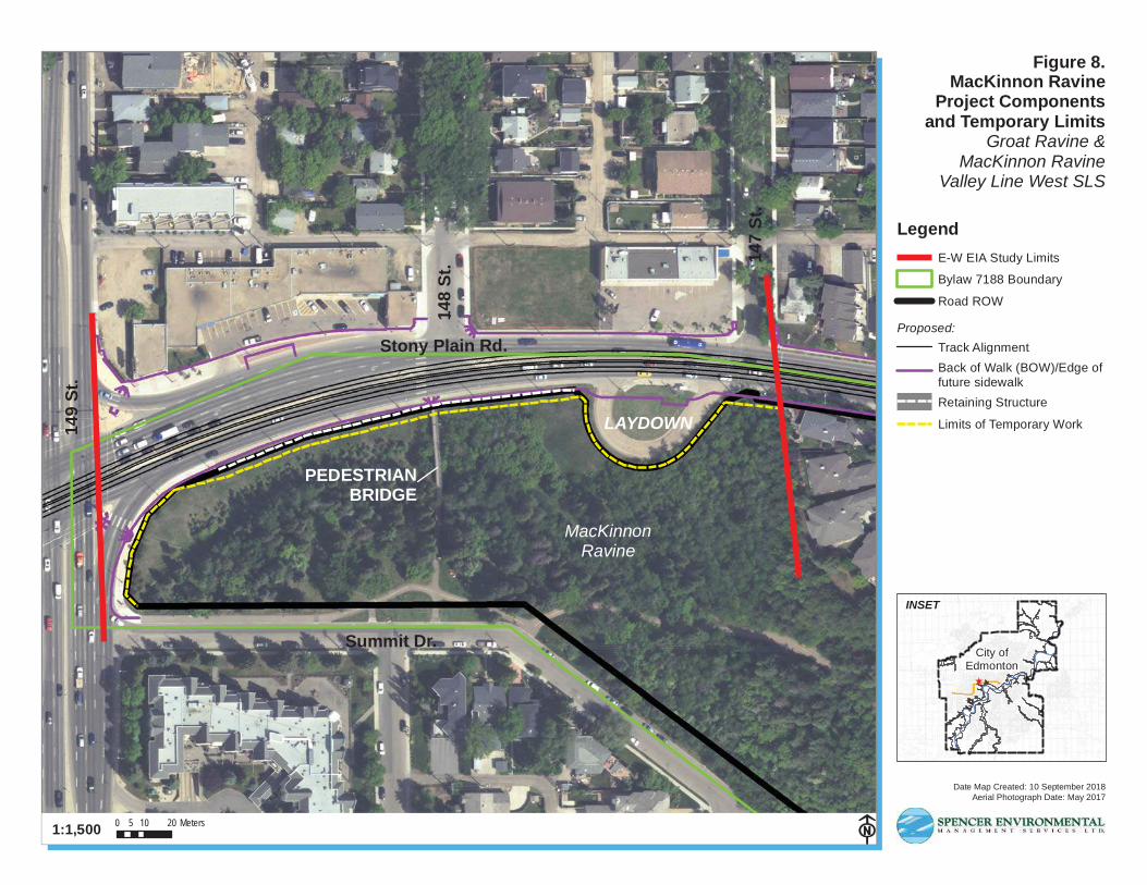
sidewalk, and some transit infrastructure adjustment (Figures 7 and 8). In this case, all
proposed new infrastructure will be located inside the existing ROW except a short segment
of sidewalk, to the east of the bus turnaround. That sidewalk segment is not located within
the ravine proper (Figure 8). However, some of the associated work activities have
potential to encroach beyond the existing road ROW and into MacKinnon Ravine.
Following are brief descriptions of the key project components relevant to MacKinnon
Ravine.
2.2.1 Sidewalk Widening and Retaining Structure
The existing sidewalk is so close to the steep ravine slope that the slight adjustment south
needed by this project requires a small area of fill to support the sidewalk (Figure 9a-c).
To avoid permanent encroachment into the ravine, the Proponent will be required to install
a short retaining structure (e.g., a wall) to retain the fill rather than a tapered slope (Figure
9). All sidewalk, fill, and retaining structures will be located within the existing roadway
ROW. There is, however, a need for a temporary work area at the top of the ravine in
support of these works. This will be limited to a maximum 3 m wide strip (Figure 8). This
temporary work area is the primary incursion into MacKinnon Ravine and Bylaw 7188
lands.
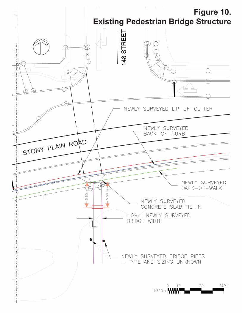
2.2.2 Existing Pedestrian Bridge Modification
Because the existing pedestrian bridge that crosses MacKinnon Ravine at this location
directly terminates at the south edge of the existing sidewalk, the north end of that
footbridge must also be modified (Figure 10). The bridge work is very localized and
expected to be straightforward. The bridge work details will be finalized by the Proponent,
but it appears that the first concrete beam would be affected, and the beam and foundation
would need to be replaced. The bridge would be marginally shorter and stringers of the
first span would need to be cut. The last city bridge report indicated the pedestrian bridge
Spencer Environmental
September 2018 Site Location Study for VL-W Page 4
Groat and MacKinnon Ravines
to be in good condition (Marzan, pers. comm.) The bridge work would be located within
MacKinnon Ravine.
2.2.3 Decommissioning of Bus Turnaround
The existing bus turnaround, fully situated within the existing roadway ROW, will be
replaced with a new bus bay and sidewalk along SPR (Figure 7 and 8). The turnaround
area will be used as a laydown area and then decommissioned, through removal of the
existing asphalt, and reclaimed to a natural area according to a detailed reclamation plan to
be developed by the Proponent. Reclamation boundaries will respect the established
temporary work limit (also the roadway ROW in this case).
2.2.4 Landscaping
The landscape plan for the MacKinnon Ravine segment (Figure 11) indicates that the full
length of the temporary work area associated with construction of the sidewalk and
retaining wall within Bylaw 7188 lands will be reclaimed to a new natural area. That
natural area will extend west from the former turnaround in a thin band to the to the corner
of 149 Street and Summit Drive. A few ornamental trees are shown planted near the new
bus bay adjacent the sidewalk in the ROW. The EIA elaborates on landscaping
requirements in those areas as mitigation for impacts to natural vegetation near the
pedestrian bridge.
Spencer Environmental
September 2018 Site Location Study for VL-W Page 5
Groat and MacKinnon Ravines
VL-W LOCATION ANALYSIS AND JUSTIFICATION
3.1 Alternative Location Review
3.1.1 VL-W Alignment
The LRT network in general, and the VL-W specifically, is an important City priority
project. Planning of corridors and specific alignments has been a long-term, complex
process that involved extensive public engagement and Council approval at multiple key
planning stages. Planning for the VL-W line has been in consideration for many years but
became more focused in 2008/2009 with the initiation of alignment evaluation and
associated key Council decisions. In 2009, the City officially adopted the LRT Network
Plan, which defined the future size, scale and operation of Edmonton’s LRT system.
Specifically, the plan identified a six-legged LRT system to serve all sectors of the city,
with the VL-W as one component leg. Following approval of the Network Plan, a
subsequent important planning step was evaluation of several alternative VL-W (and SE)
corridors to arrive at a recommended corridor. The resultant Concept Plan that specified
the Valley Line Southeast to West corridor, track alignment and station locations for the
majority of the Valley Line (LRT) was approved by City Council in January 2011, with
the downtown segment approved in February 2012. The alignment now being assessed that
utilizes SPR and crosses over Groat Ravine and near MacKinnon Ravine has thus been the
accepted alignment with periodic minor revisions, since 2011.
3.1.2 Groat Ravine Crossing Alternatives
Adjusting the VL-W alignment to avoid crossing Groat Ravine would have necessitated
shifting the alignment north to 107 Avenue. That option did not achieve LRT service goals
and was not pursued. Retrofit or rehabilitation of the existing SPR bridge to accommodate
the required LRT added that was width technically not feasible. It happens that the existing
SPR bridge is more than 50 years old and nearing the end of its lifespan. Therefore,
regardless of the LRT, a new bridge at SPR was inevitable in the near future (Marzan
pers.comm.). The VL-W project, if it proceeds in the next few years, has only slightly
expedited that bridge replacement. Incorporating the LRT into the new SPR crossing
eliminated the need for yet another LRT-specific crossing over the ravine, which represents
good environmental practice.
During preliminary engineering, several design alternatives were examined with a view to
minimizing the project footprint in the ravine. The following decisions resulted: a bridge
design that removed piers in the ravine; locating construction laydown areas out of the
ravine and away from parkland near the top-of-ravine at Connaught Drive; use of a
retaining wall at the area of fill rather than use of a tapered slope. Adoption of a bridge
design that eliminated abutments in the ravine was not technically possible. This would
have required a deeper superstructure and a raised road profile which would have
negatively impacted adjacent residential properties and local drainage (Marzan
pers.comm.).
Spencer Environmental
September 2018 Site Location Study for VL-W Page 6
Groat and MacKinnon Ravines
3.1.3 MacKinnon Ravine Alternatives
At MacKinnon Ravine, LRT-related temporary encroachment into the ravine could only
have been avoided by either deviating from City design standards for infrastructure such
as sidewalks, or shifting new infrastructure to the north and encroaching on private
properties. Widening to the south, with the temporary encroachment on the ravine was
selected as the less intrusive option. Requiring a retaining structure along the new sidewalk
was then deliberately adopted to reduce the encroachment into the ravine.
3.2 River Valley Dependencies
Unlike many recreational or utility projects proposed to be located within the river valley
system, this project is not dependent on a river valley location. Rather, this project happens
to intersect with bylaw lands, as part of a larger tablelands project.
3.3 Overview of Bylaws/Plans/Policies
In addition to the various LRT plans that have been approved by Council for this alignment,
the proposed project is consistent with the following City plans: The Way We Grow:
Municipal Development Plan (Bylaw 15100); The Way We Live: Edmonton’s People Plan;
The Way We Move: Transportation Master Plan. Furthermore, because it limits
transportation crossings and reduces encroachment in the river valley system to the degree
possible, the project is also consistent with the goals of the North Saskatchewan River
Valley Area Redevelopment Plan (Bylaw 7188).
Spencer Environmental
September 2018 Site Location Study for VL-W Page 7
Groat and MacKinnon Ravines
CONSTRAINTS ANALYSIS GROAT RAVINE AND
MACKINNON RAVINE
Following is an analysis of the social, financial, environmental and institutional constraints
that make this project’s intersections with Bylaw 7188 boundaries essential.
4.1 Social Constraints
The long corridor and alignment planning history led to a VL-W alignment that fulfills the
City’s objective of an urban style LRT extension to west Edmonton. That history and
those multiple objectives amount to a social constraint that has led to the need to intersect
with bylaw lands. This is particularly true of Groat Ravine. Furthermore, the City’s
objective to always minimize the need to acquire private property to realize civil capital
projects has contributed to the decision to widen the SPR to the south near MacKinnon
Ravine rather than to the north where private properties could be affected.
4.2 Financial
There are no cost estimates available that are directly relevant to this SLS. There are no
apparent financial constraints that require the two bylaw land intersections. It can be argued
that combining the near-future need for replacing the SPR bridge with the VL-W project
has financial benefits.
4.3 Environmental Constraints
While environmental considerations resulted in careful design and slightly reduced project
footprints within Bylaw 7188 lands, there were no environmental constraints that required
the project to intersect with bylaw lands. However, the geography of the two ravines did
influence design in those locations. At Groat Ravine, the established SPR vertical
alignment at the approaches to the ravine did constrain available bridge design options and
required the bridge abutments to be situated on the ravine slopes. At MacKinnon Ravine,
the proximity of the sidewalk to the ravine slope necessitated the temporary encroachment
into the ravine.
4.4 Institutional Constraints
The VL-W is a current City priority project and the location of the VL-W within the
existing SPR ROW is consistent with City transportation master planning. This high-level
planning followed by more specific LRT planning is an institutional constraint that has led
to the alignment as presented here.
Spencer Environmental
September 2018 Site Location Study for VL-W Page 8
Groat and MacKinnon Ravines
CONCLUSION
The selected VL-W alignment and Reference Design does encroach into Bylaw 7188 lands
at two locations. VL-W planning over the last decade has confirmed that this alignment is
the optimal alignment, the one that best meets City values and objectives. This report
briefly examines the high-level alternatives that were rejected and describes the finer scale
design alternatives that were integrated into the project to reduce encroachment into bylaw
lands. This document also identifies the financial, social, environmental and institutional
constraints that affected the project at these bylaw land locations. The primary constraints
making these intersections with bylaw lands essential are related to the social and
institutional constraints associated with the City’s LRT network servicing vision.
Spencer Environmental
September 2018 Site Location Study for VL-W Page 9
Groat and MacKinnon Ravines
REFERENCES
6.1 Literature Cited
Spencer Environmental. 2018a. Environmental Impact Assessment Pursuant to Bylaw
7188 for Valley Line West Light Rail Transit (LRT) Crossing at Groat
Ravine. Prepared for the City of Edmonton. Edmonton, Alberta.
Spencer Environmental. 2018b. Environmental Impact Assessment Pursuant to Bylaw
7188 for Valley Line West Light Rail Transit (LRT) Activities near MacKinnon
Ravine. Prepared for the City of Edmonton. Edmonton, Alberta.
6.2 Personal Communications
Marzan, Roleza Jean, P.Eng., Senior Civil Engineer, Integrated Infrastructure Services,
LRT Delivery.
Spencer Environmental
September 2018 Site Location Study for VL-W Page 1
Groat and MacKinnon Ravines
Appendix A: Figures
Date Map Created: 10 September 2018
North Saskatche wanR
ive
r
AN
TH
ON
Y H
EN
DA
Y D
R.
87 AVE.
15
6 S
T.
WHITEMUD DR.
104 AVE.
STONY PLAIN RD.
GROATRAVINEMACKINNON
RAVINEStony Plain Rd.
Aerial Photograph Date: May 2017
0 1,000 2,000500 Meters1:70,000
Figure 1.Project Location
Groat Ravine &MacKinnon Ravine
Valley Line West SLS
Legend
Proposed Track Alignment
Bylaw 7188 Boundary
TUC & Anthony Henday Drive
INSET - GROAT RAVINE
INSET - MACKINNON RAVINE
14
9 S
t.
STONY PLAIN RD.
GR
OAT
RD
.
STONY PLAIN RD.
Figure 2.
BY
LA
W 7
188
BO
UN
DA
RY
PROJECT
AREA
*Source: Adapted from Roadways, Alignment drawing VLW-0404-02-PE-132, for presentation.**Note: City of Edmonton Bylaw 7188 (2008) boundary and project area boundary added by Spencer Environmental for reference.
VL-W Bridge & Roadway Design at Groat Ravine
Figure 3.
BY
LA
W 71
88
BO
UN
DA
RY
*Note: City of Edmonton Bylaw 7188 (2008) boundary added by Spencer Environmental for reference.
TYPICAL SECTION1:50
C BRIDGE
L
L
TRACK TRACKC WESTBOUND LC EASTBOUND
4.140
4.200SIDEWALK
7.535DYNAMIC ENVELOPE
1.6851.710
4.000LANE
0.4154.200SIDEWALK
4.000LANE
0.415 0.300 MIN0.300 MIN
PEDESTRIAN / BICYCLERAILING (TYP)
ACP ANDWATERPROOFING
DECK
GIRDER
3.546 (AT C BRG ABUT 1)3.751 (AT C BRG ABUT 2)
0.240
2.00%2.00%
LL
BICYCLE RAILING
1.22
0CONCRETE SEPARATIONBARRIER (TYP)
PROPOSEDTRACK UTILITYACCOMMODATION
VLW-0412-01-PE-004
AMAN
DOC
/ Apr
il 5, 2
018
/ P:\6
0528
911\
900-
CAD_
GIS
\910
-CAD
\20-
SHEE
TS\S
T\25
- SH
EETS
\STO
NY P
LAIN
RO
AD B
RIDG
E\5
VLW
-041
2-01
-PE-
004.
DWG
STONY PLAIN ROAD OVER GROAT ROAD BRIDGE
Figure 4.
500
MIN
1200
MA
X
CONCRETE SLOPEPROTECTION
GIRDER
1000MIN
TOP BENCH
SINGLE ROW OF PILESCENTERED WITH THECENTERLINE OF BEARINGSAND ABUTMENT SEAT
ABUTMENT SEAT
BOND BREAKER B/WABUTMENT SEATAND STEEL CASING
LC BRG ABUT 2
U/S WINGWALL(NORTH)
U/S WINGWALL(SOUTH)
8075 MINSOUTH WINGWALL
28000MSE RETAINING WALL
EXISTING GROUND AT FACEOF MSE RETAINING WALL
TOP OF COPING CAPTOP OF RAIL
SECTIONB0412-01 1:75
005
300MIN
CONCRETEMSE RETAININGWALL FOOTING
TOP OF MSERETAINING WALL
PERFORATED WEEPING DRAIN PIPEC/W FILTER FABRIC SOCK TO DRAINTOWARDS HEADSLOPE (TYP)
1000
MIN
END OF WINGWALL(NORTH)
1200
MA
X50
0M
IN
CONCRETE SLOPEPROTECTION
GIRDER
1000MIN TOP BENCH
LC BRG ABUT 1
SLEEPER SLAB
1125MIN
600
6000 MIN (ON SKEW)
CIP CONCRETEAPPROACH SLAB
FILL LINE
PERFORATED WEEPING DRAIN PIPEC/W FILTER FABRIC SOCK TO DRAIN
TOWARDS HEADSLOPE (TYP)
SINGLE ROW OF PILESCENTERED WITH THE
CENTERLINE OF BEARINGSAND ABUTMENT SEAT
ABUTMENT SEAT
BOND BREAKER B/WABUTMENT SEATAND STEEL CASING
EXISTING GROUND
END OF WINGWALL
U/S WINGWALL
TOP OF RAIL
SECTIONA0412-01 1:75
005
PERFORATED WEEPING DRAINPIPE C/W FILTER FABRIC SOCK
TO DRAIN TOWARDS NORTHSIDE SLOPES
GRANULARBACKFILL
SECTIONC0412-01
0051:25
MSE RETAINING WALL
50
1
GEOGRID ORSTRAPS (TYP)
BACKFILL
600
SIDEWALK ANDCURB
COPING CAP
1000
MIN EXISTING
GROUND
CONCRETE MSE RETAININGWALL FOOTING
4200SIDEWALK
TOP OFFINISHED
ROADWAY
1220
100
MIN0.06
1.00
CONCRETEMOMENT SLAB
TOP OF RAIL
SECTION
SLEEPER SLAB
CIP CONCRETEAPPROACH SLAB
FILL LINE
D0412-01 1:75
005
EMBEDDEDTRACK SLAB
VLW-0412-01-PE-006
AMAN
DOC
/ Apr
il 5, 2
018
/ P:\6
0528
911\
900-
CAD_
GIS
\910
-CAD
\20-
SHEE
TS\S
T\25
- SH
EETS
\STO
NY P
LAIN
RO
AD B
RIDG
E\7
VLW
-041
2-01
-PE-
006.
DWG
STONY PLAIN ROAD OVER GROAT ROAD BRIDGEAS SHOWN
Figure 5.
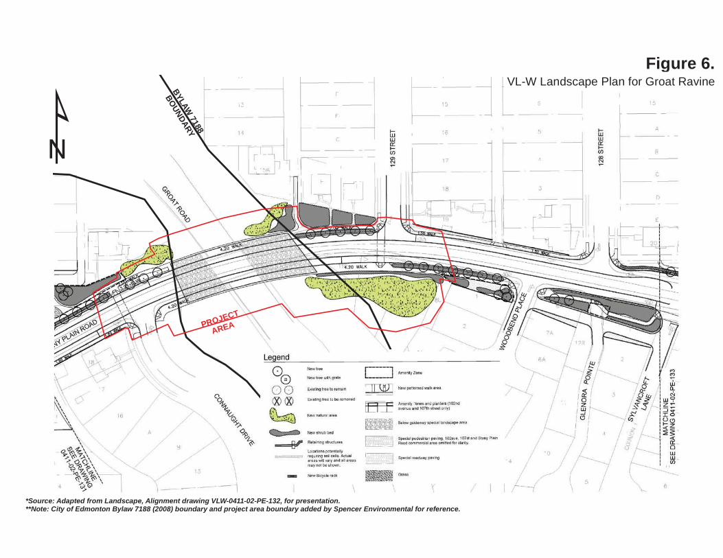
Figure 6.
BY
LA
W 71
88
BO
UN
DA
RY
PROJECT
AREA
VL-W Landscape Plan for Groat Ravine
*Source: Adapted from Landscape, Alignment drawing VLW-0411-02-PE-132, for presentation.**Note: City of Edmonton Bylaw 7188 (2008) boundary and project area boundary added by Spencer Environmental for reference.
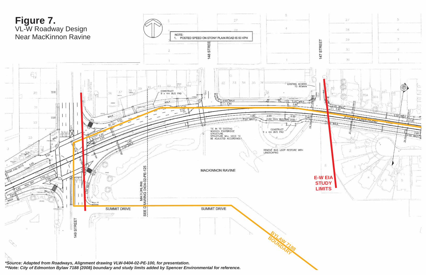
Figure 7.
BYLAW 7188
BOUNDARY
E-W EIA
STUDY
LIMITS
*Source: Adapted from Roadways, Alignment drawing VLW-0404-02-PE-100, for presentation.**Note: City of Edmonton Bylaw 7188 (2008) boundary and study limits added by Spencer Environmental for reference.
VL-W Roadway DesignNear MacKinnon Ravine
Date Map Created: 10 September 2018
Stony Plain Rd.
14
9 S
t.
MacKinnonRavine
LAYDOWN
Summit Dr.
14
8 S
t.
PEDESTRIANBRIDGE
14
7 S
t.
Aerial Photograph Date: May 2017
0 10 205 Meters1:1,500
INSET
City ofEdmonton
Figure 8.MacKinnon Ravine
Project Componentsand Temporary Limits
Groat Ravine &MacKinnon Ravine
Valley Line West SLS
Legend
Road ROW
Proposed:
Back of Walk (BOW)/Edge offuture sidewalk
Track Alignment
Retaining Structure
Limits of Temporary Work
E-W EIA Study Limits
Bylaw 7188 Boundary
STONYROAD
PLAIN108+300
108+400
108+308.153
108+336.042
108+364.360
208+
300
208+
400
108+
300
108+
400
VALLEY LINE WEST LRT
DM
AR
TIN
/ Ju
ne 2
6, 2
018
/ \\E
DM
FS\P
RO
JEC
TS\1
4800
\148
54_V
ALL
EY
_LIN
E_L
RT_
WE
ST_
DE
SIG
N_&
_OE
\02_
CA
DD
\20_
DR
AFT
ING
\230
0_R
OA
DW
AY
S\E
XH
IBIT
S-2
017\
MC
KIN
NO
N X
-SE
CTS
148
STR
EE
T\V
LW-0
404-
02-P
E-2
23-M
CK
INN
ON
PLA
N.D
WG
Checked By:Designed By:
Date Issued:
Drawn By: S.A.M.R.M.J.M.26-06-2018
MCKINNON RAVINE CROSS SECTIONS
148
STR
EE
T N
W
STONY PLAIN ROAD NW
108+308 CROSS SECTION
108+336 CROSS SECTION 108+364 CROSS SECTION
Figure 9a.
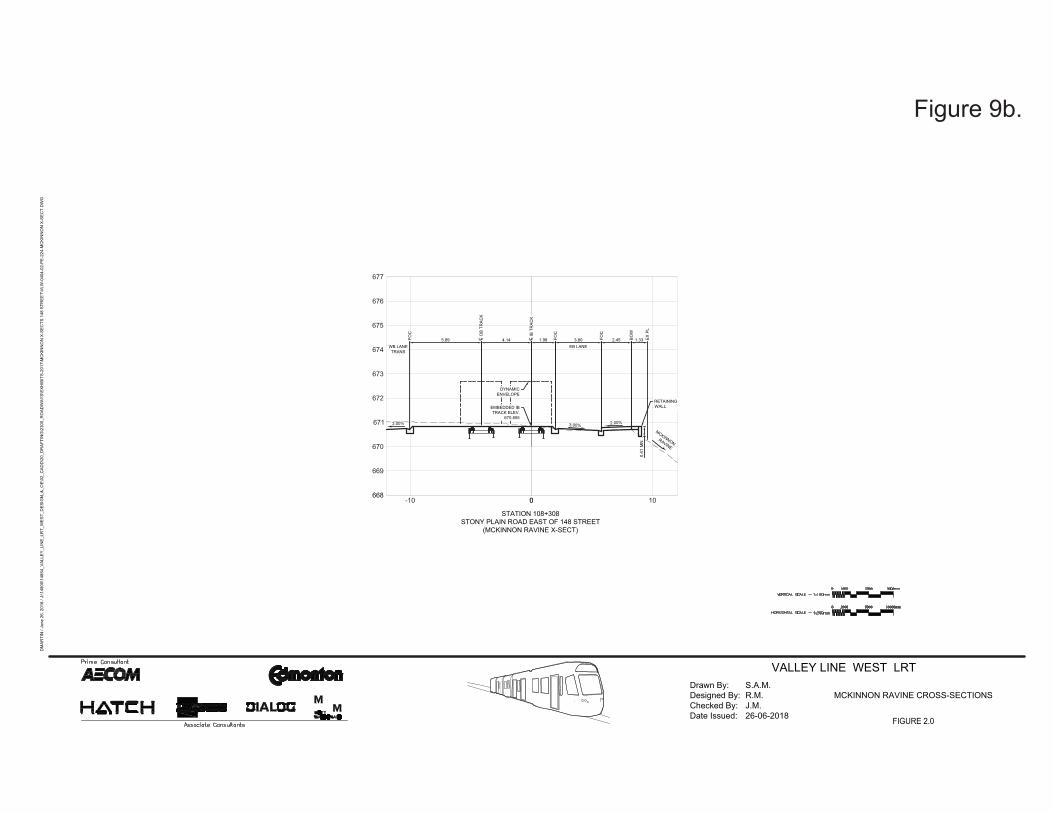
668
669
670
671
672
673
674
675
676
677
0 100-10
3.00%2.00%
5.89 4.14 1.98 FOC
WB LANETRANS
3.80EB LANE
2.45FOC
BOW
1.33 EX P
L
FOC
L IB
TR
ACK
CL O
B TR
ACK
C
MCKINNONRAVINE
STATION 108+308STONY PLAIN ROAD EAST OF 148 STREET
(MCKINNON RAVINE X-SECT)
DYNAMICENVELOPE
EMBEDDED IBTRACK ELEV.
670.855
RETAININGWALL
0.82
MN
2.00%
VALLEY LINE WEST LRT
DM
ARTI
N /
June
26,
201
8 / J
:\148
00\1
4854
_VAL
LEY_
LIN
E_LR
T_W
EST_
DES
IGN
_&_O
E\02
_CAD
D\2
0_D
RAF
TIN
G\2
300_
RO
ADW
AYS\
EXH
IBIT
S-20
17\M
CKI
NN
ON
X-S
ECTS
148
STR
EET\
VLW
-040
4-02
-PE-
224-
MC
KIN
NO
N X
-SEC
T.D
WG
Checked By:Designed By:
Date Issued:
Drawn By: S.A.M.R.M.J.M.26-06-2018
MCKINNON RAVINE CROSS-SECTIONS
0.41
Figure 9b.
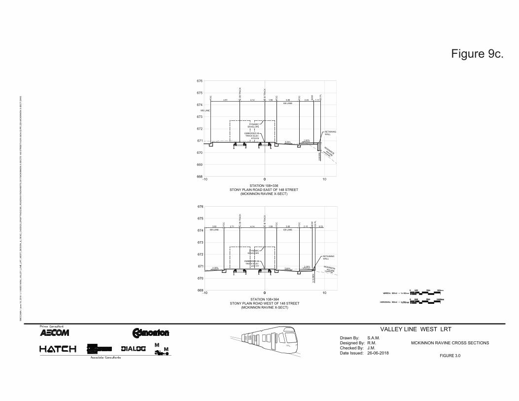
668
669
670
671
672
673
674
675
676
0 100-10
669
670
671
672
673
674
675
676
0 100-10
DYNAMICENVELOPE
EMBEDDED IBTRACK ELEV.
670.777
4.91 4.14 1.98 FOC
3.80EB LANE
2.45FOC
BOW
1.11 EX P
L
L IB
TR
ACK
CL O
B TR
ACK
CFOC
DYNAMICENVELOPE
EMBEDDED IBTRACK ELEV.
670.816
2.00%
4.14 1.98 FOC
3.80EB LANE
2.15FOC
BOW
L IB
TR
ACK
CL O
B TR
ACK
C2.713.80EB LANE
FOC
0.53EX P
L
MCKINNONRAVINE
MCKINNONRAVINE
STATION 108+364STONY PLAIN ROAD WEST OF 148 STREET
(MCKINNON RAVINE X-SECT)
STATION 108+336STONY PLAIN ROAD EAST OF 148 STREET
(MCKINNON RAVINE X-SECT)
1.31
MN
RETAININGWALL
RETAININGWALL
WB LANE
2.00%
2.00%
3.00%
3.00%
0.19
MIN
VALLEY LINE WEST LRT
SMC
CAN
N /
June
18,
201
8 / J
:\148
00\1
4854
_VAL
LEY_
LIN
E_LR
T_W
EST_
DES
IGN
_&_O
E\02
_CAD
D\2
0_D
RAF
TIN
G\2
300_
RO
ADW
AYS\
EXH
IBIT
S-20
17\M
CKI
NN
ON
X-S
ECTS
148
STR
EET\
VLW
-040
4-02
-PE-
225-
MC
KIN
NO
N X
-SEC
T.D
WG
Checked By:Designed By:
Date Issued:
Drawn By: S.A.M.R.M.J.M.26-06-2018
MCKINNON RAVINE CROSS SECTIONS
0.66
0.10
Figure 9c.
148
STR
EE
T
PLAIN ROAD
STONY
RM
ULL
ER
/ Ju
ly 6
, 201
8 / J
:\148
00\1
4854
_VA
LLE
Y_L
INE
_LR
T_W
ES
T_D
ES
IGN
_&_O
E\0
2_C
AD
D\2
0_D
RA
FTIN
G\2
300_
RO
AD
WA
YS
\EX
HIB
ITS
-201
7\M
CK
INN
ON
RA
VIN
E F
OO
TBR
IDG
E R
EFE
RE
NC
E F
ILE
S\V
LW-M
AC
KIN
NO
N R
AV
INE
SU
RV
EY
-GR
ND
-RO
GE
R-J
ULY
-06-
2018
.DW
G
S
S
L
5.56
m
5.50
m
Figure 10.Existing Pedestrian Bridge Structure
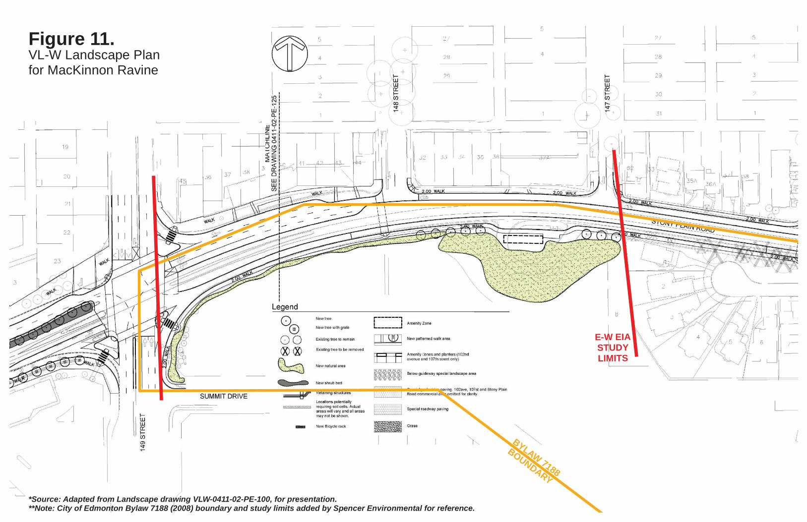
Figure 11.
BYLAW 7188
BOUNDARY
E-W EIA
STUDY
LIMITS
*Source: Adapted from Landscape drawing VLW-0411-02-PE-100, for presentation.**Note: City of Edmonton Bylaw 7188 (2008) boundary and study limits added by Spencer Environmental for reference.
VL-W Landscape Planfor MacKinnon Ravine