vector tile benchmark
TRANSCRIPT

FOSS4G Bucharest 30.8.2019 MVT Benchmark
FOSS4G 2019
Vector tile benchmark
Pirmin Kalberer, @implgeoSourcepole, Switzerland
Karsten Vennemann

FOSS4G Bucharest 30.8.2019 MVT Benchmark
FOSS4G benchmark tradition
> WMS benchmark 2008

FOSS4G Bucharest 30.8.2019 MVT Benchmark
FOSS4G benchmark tradition
> WMS benchmark 2008

FOSS4G Bucharest 30.8.2019 MVT Benchmark
FOSS4G benchmark tradition
> WMS benchmark 2010

FOSS4G Bucharest 30.8.2019 MVT Benchmark
A vector tile benchmark
> Natural Earth dataset
> Data stored in PostGIS
> Test style:
> https://github.com/pka/mvt-benchmark
FOSS4G Bucharest 30.8.2019 MVT Benchmark
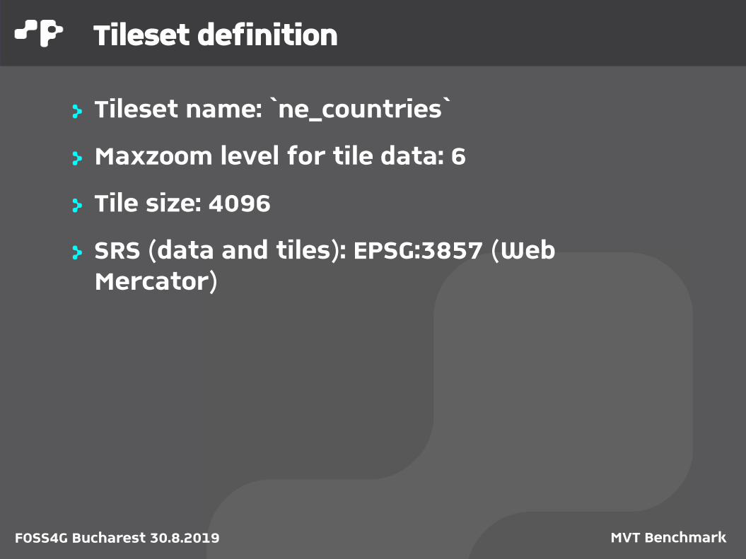
Tileset definition
> Tileset name: `ne_countries`
> Maxzoom level for tile data: 6
> Tile size: 4096
> SRS (data and tiles): EPSG:3857 (Web Mercator)

FOSS4G Bucharest 30.8.2019 MVT Benchmark
Layer definition
Name Geom. type
Buffer
Simplify Table Attributes Conditions
country MULTIPOLYGON
3 yes ne_10m_admin_0_countries
adm0_a3, mapcolor7
min_zoom <= {z}
country-name
POINT 0 no ne_10m_admin_0_country_points
abbrev, name
-
geo-lines (z=1..4)
MULTILINESTRING
0 no ne_50m_geographic_lines
name -
geo-lines (z=5..6)
MULTILINESTRING
0 no ne_10m_geographic_lines
name -
land-border-country
MULTILINESTRING
0 yes ne_10m_admin_0_boundary_lines_land
- min_zoom <= {z}
state MULTILINESTRING
0 yes ne_10m_admin_1_states_provinces_lines
adm0_a3 min_zoom <= {z}

FOSS4G Bucharest 30.8.2019 MVT Benchmark
Benchmark measurment #1
> How long does it take to generate all tiles (single node / multiple nodes)

FOSS4G Bucharest 30.8.2019 MVT Benchmark
Vector tile creation
> Read geodata within tiles borders
> Clip geometries
> Simplify geometries> Polygons: e.g. SnapToGrid> Lines: e.g. Douglas-Peucker
> (Generate label points)
> Deliver MVT (Protobuf) format

FOSS4G Bucharest 30.8.2019 MVT Benchmark
Benchmark measurment #2
> How many requests/s does the tile server deliver in web server mode

FOSS4G Bucharest 30.8.2019 MVT Benchmark
Serving vector tiles
> MVT creation on request with file cache (capabable of delivering live data)
> Not part of benchmark:> Serving static MVT files directly
> Webserver (Apache, Nginx)> Service: S3, etc.
> Cache-, CORS- headers> Layer concatenation
> Measured with wrk, a high performance http load testing tool

FOSS4G Bucharest 30.8.2019 MVT Benchmark
Contestants 2019
> T-rex
> UMN Mapserver
More tile servers:
https://github.com/mapbox/awesome-vector-tiles

FOSS4G Bucharest 30.8.2019 MVT Benchmark
t-rex
> Serve vector tiles> Live tiles from PostGIS databases and GDAL
vector formats> Zero-configuration mode> Embedded webserver> Visual styling with Maputnik

FOSS4G Bucharest 30.8.2019 MVT Benchmark
t-rex
> Generate vector tiles> Tile generation command with simple
parallelization> Generate configuration template> Support for custom tile grids

FOSS4G Bucharest 30.8.2019 MVT Benchmark
t-rex
> Easy to Use> Auto-detection of layers in database> Single human readeable configuration file> Automatic reprojection to grid CRS> Install package or run in a Docker container

FOSS4G Bucharest 30.8.2019 MVT Benchmark
MapServer
> Originally developed at the University of Minnesota (UMN), short “MapServer”> one of the most mature open source projects
(1994)> written in C
> Main Focus> rendering spatial data> development environment for spatially-
enabled internet applications

FOSS4G Bucharest 30.8.2019 MVT Benchmark
MapServer
> Map output> CGI mapserv (Linux) and mapserv.exe
(windows)> MapScript API available for Python, PHP, Perl,
and Java> Map/Layer configuration text file .map
> Formats> In: PostGIS, Oracle Spatial ArcSDE, WMS, GDAL
and OGR formats> Out: GIF, JPG, PNG, all GDAL formats, WFS and
WMS

FOSS4G Bucharest 30.8.2019 MVT Benchmark
Configuration for benchmark data
> T-rex: TOML with embedded SQL
> MapServer: Map-File with embedded SQL + XML-File for MapCache

FOSS4G Bucharest 30.8.2019 MVT Benchmark
t-rex

FOSS4G Bucharest 30.8.2019 MVT Benchmark
MapServer
> Mapfile

FOSS4G Bucharest 30.8.2019 MVT Benchmark
MapCache
> Mapcache.xml

FOSS4G Bucharest 30.8.2019 MVT Benchmark
Test environment
> Linux Notebook with i5-5200U CPU @ 2.20GHz2 Cores / 4 Threads
> 8GB RAM
> SSD Disk
> 3 benchmark runs
FOSS4G Bucharest 30.8.2019 MVT Benchmark
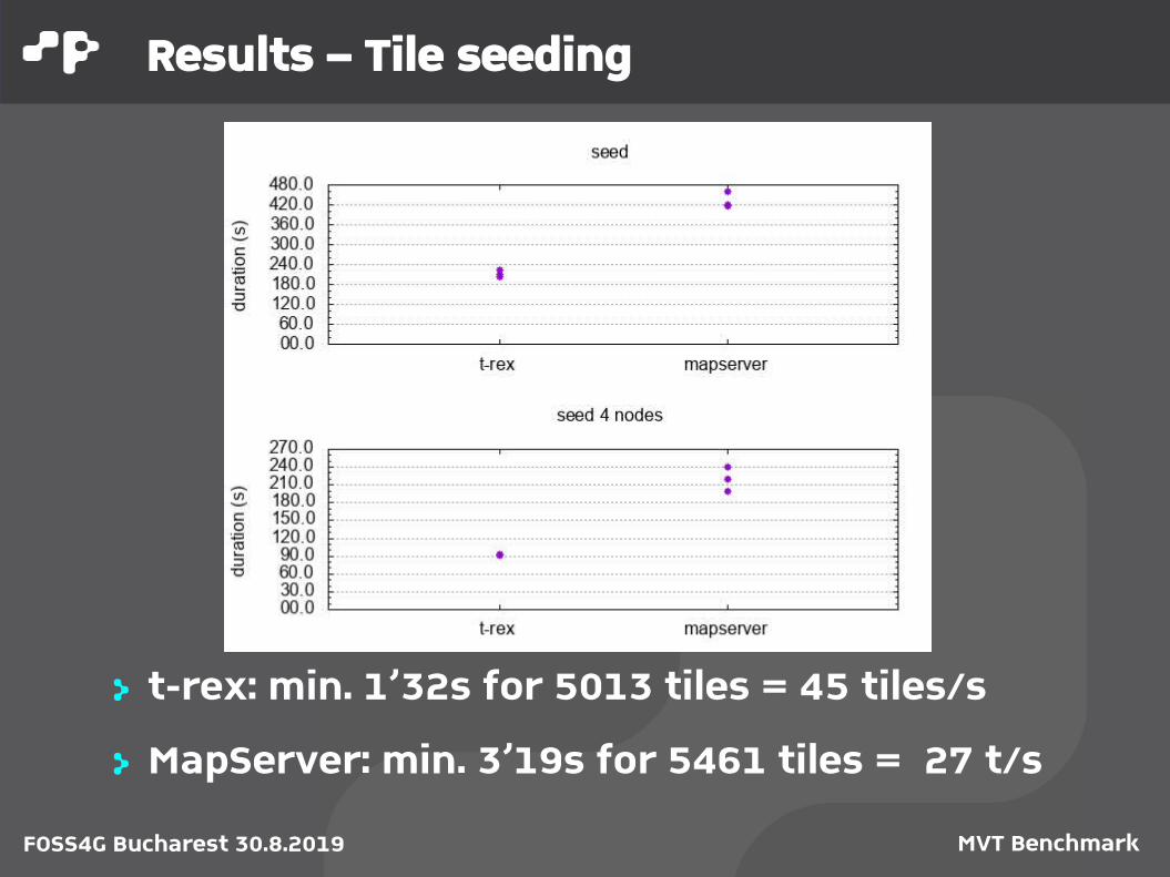
Results – Tile seeding
> t-rex: min. 1’32s for 5013 tiles = 45 tiles/s
> MapServer: min. 3’19s for 5461 tiles = 27 t/s
FOSS4G Bucharest 30.8.2019 MVT Benchmark
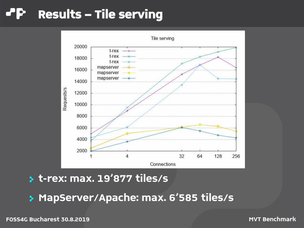
Results – Tile serving
> t-rex: max. 19’877 tiles/s
> MapServer/Apache: max. 6’585 tiles/s

FOSS4G Bucharest 30.8.2019 MVT Benchmark
Open points
> Benchmark> Clarify expected number of tiles> Adapt scripts for running on multiple servers> Measure simplification (visual check only)?> Verify clipping?
> MapServer> Not implemented: data query filter with “z”
parameter (use a template?)> Ogrinfo error message:
Geometry: Multi Point Feature Count: 1 ERROR 1: Parsing error occurred at line 945

FOSS4G Bucharest 30.8.2019 MVT Benchmark
Conclusions
> Benchmarking helps projects to improve
> Benchmarking helps users to see differencate projects
> Open for more contestants
> See you in Calgary!

FOSS4G Bucharest 30.8.2019 MVT Benchmark
FOSS4G 2019
Thank you!
Pirmin Kalberer@implgeo
Karsten VennemannTerra GIS LTD