vessel transits through the olympic coast national … transits through olympic coast national...
TRANSCRIPT

Vessel Transits Through Olympic Coast National Marine Sanctuary and Area to Be Avoided (ATBA) - 2015 Estimated Compliance
Introduction Designated in 1994, Olympic Coast National Marine Sanctuary (OCNMS or sanctuary) is a place of regional, national and global significance. The sanctuary, which is connected to both the Big Eddy Ecosystem and the California Current Large Marine Ecosystem, is the site of one of North America’s most productive marine regions and spectacular, undeveloped shorelines. Potential release of oil or other hazardous material from a major marine accident is regarded as the most serious threat to resources within and qualities of the sanctuary. Prevention of spills is therefore one of OCNMS’s highest priorities. As a steward of these vitally important natural resources, OCNMS will continue to collaborate with other agencies and user groups to reduce the potential for oil spills and improve contingency planning for spill response. OCNMS’s major oil spill prevention initiative is an International Maritime Organization (IMO) designated Area to be Avoided (ATBA). This report is the sanctuary’s annual reporting of estimated ATBA compliance rates. Data from Automatic Identification System transceivers received by satellite (S-AIS) is collected, vessel details are added and compliance to the ATBA is evaluated. Our evaluation of the 2015 vessel transits off the Washington coast shows compliance rates virtually identical to 2014
(97.8% in 2014 and 97.7% in 2015). Estimated compliance of the ATBA continues to reflect a high degree of cooperation by the maritime industry.
Background During the sanctuary designation process NOAA worked with the U. S. delegation to the IMO to designate an Area to be Avoided (ATBA) off the coast of Washington to reduce the risk of marine casualties including oil spills, and the resulting environmental damage to Olympic Coast National Marine Sanctuary. For more information on the ATBA see the attached informational flyer (Figures 9 and 10) or visit http://olympiccoast.noaa.gov/ protect/incidentresponse/atba.html. This flyer is also included in the Washington Department of Ecology’s (Ecology) Vessel Entries and Transits for Washington Waters (VEAT) publication and U. S. Coast Guard Sector Puget Sound Vessel Traffic Service’s (VTS) User’s Manual. In addition ATBA boundaries and provisions are included in official navigational products, such as nautical charts and Coast Pilot 7.
Figure 1: Vessel Transit Analysis Area.
Vessel Transits Through Olympic Coast National Marine Sanctuary April 2016 and Area to Be Avoided (ATBA) - 2015 Estimated Compliance
2
ATBA Provisions All ships and barges that carry oil or hazardous materials as cargo, and all ships 400 gross tons and above, solely in transit are advised to transit outside of this ATBA. OCNMS, in cooperation with the U.S. and Canadian coast guards, monitors vessel compliance under this voluntary program. While the ATBA does not apply to government vessels, the sanctuary, in partnership with the U.S. and Canadian coast guards, seeks to ensure that government vessels comply when in transit. This includes NOAA, U.S. and Canadian Coast Guard vessels and the U.S. Navy. It is important to understand the implications of the ATBA provision “solely in transit”. The ATBA was not intended to preclude lawful operations of vessels within the ATBA. Examples include fishing, search and rescue, and research vessels that may conduct operations off Washington’s outer coast. When these vessels are moving through the area en route to working grounds beyond the ATBA, or solely in transit, we request their compliance with the ATBA. While we recognize that there are vessels over 400 gross tons that are legitimately conducting operations in the ATBA, we do not attempt to adjust the estimated compliance numbers to account for this. For that reason some vessel types, such as fishing and research vessels, will likely show an artificially lower compliance rate because all their occurrences in the ATBA are counted as non-compliance. The reason for this approach is the difficulty of determining the nature of some transits. In some cases it is fairly obvious from the nature of the track line that a research or fishing vessel is conducting operations, in other cases it is not as obvious. This challenge is even more pronounced when using S-AIS data. Due to this difficulty and in order to be consistent from one year to the next, OCNMS does not make adjustments to the compliance estimates for individual vessel transits based on perceived operations.
ATBA Compliance Reporting From 2004 through 2011 Ecology published estimated ATBA compliance rates as part of their annual VEAT publication. VEAT is offered by Ecology in response to public requests for information about commercial vessel traffic in Washington waters. There is considerable overlap between the VEAT report and OCNMS’s vessel monitoring efforts and the reason the two reports were for a time coordinated. When OCNMS made significant changes to their monitoring methods, additional documentation was needed. This led to the need, starting in 2012, for an independent OCNMS report. Both the VEAT (2004-2011) and OCNMS (2012-2015) reports can be downloaded at http://olympiccoast.noaa.gov/protect/ incidentresponse/vesseltraffic.html. VEAT reports following 2011 can be downloaded at Ecology’s publication page, https://fortress.wa.gov/ecy/publications/.
Discussion of Data In 2012 the sanctuary changed data sources from Canadian Coast Guard radar data to data from vessel’s S-AIS. This change in the data source provides both an improvement in spatial data coverage (the southern part of the sanctuary is now included), as well as a reduced number of positions describing transits (S-AIS data has occasional gaps in coverage), and a loss of some value-added information formerly provided by Canadian Coast Guard vessel traffic operators, such as information on tugs towing oil or chemical barges. For the initial analysis of the S-AIS data, the geographic area from 46° to 49° North Latitude and from 124° to 127° West Longitude was selected, an area covering the entire outer coast of Washington state (see Figure 1). Data from the expanded study area requires significant staff time to process, but provides improved context for understanding vessel traffic patterns. It also has value to the marine spatial planning efforts of the state of Washington, see http://www.msp.wa.gov/. The sanctuary continued this level of effort in 2015, but will continue to evaluate the increased processing effort vs. the utility of monitoring the larger area as demands on limited staff resources change. There is

Vessel Transits Through Olympic Coast National Marine Sanctuary April 2016 and Area to Be Avoided (ATBA) - 2015 Estimated Compliance
3
also an ongoing discussion within NOAA on the various benefits of monitoring vessel traffic and seeking improved sources of data for monitoring vessel traffic across wider areas. Due to the use of different data sources, OCNMS vessel classification has varied over the years. The shift from Canadian vessel radar to S-AIS data resulted in some changes in vessel type categorization between 2011 and 2012, and additional minor modifications were made in 2013 and 2014. When possible we are consistent with previous vessel type descriptions, as well as those vessel types that are in common usage, e.g., such as those used by Lloyd’s Register. For certain types of analysis we group similar vessel types into one of six vessel classes (see Table 1).
2011 Vessel Types 2012-2013 Vessel Types 2014-2015 Vessel Types Vessel Classes Bulk Carrier Bulk Carrier Bulk Carrier CARGO Ore-Bulk-Oil Vessel (OBO) Bulk Carrier Bulk Carrier CARGO Cable Layer Cable Layer Cable Layer MISC General Cargo Ship Cargo Ship Cargo Ship CARGO Heavy Load Carrier Cargo Ship Cargo Ship CARGO Non-oil Tanker Chemical Carrier Chemical Carrier CARGO Chemical Tanker Chemical Carrier Chemical Carrier TANKER Container Ship Container Ship Container Ship CARGO Dredger Dredger MISC Drill Ship Drill Ship MISC Fishing Vessel Fishing Vessel Fishing Vessel FISHING (LPG) and (LNG) Carrier1 Liquefied Gas Carrier Liquefied Gas Carrier TANKER Oil Tanker Oil Tanker Oil Tanker TANKER Cruise Ship Passenger Ship Passenger Ship PASSENGER Pollution Control Pollution Control MISC Private Vessel Private Vessel MISC Public Vessels2 Public Vessels MISC Refrigerated Ship Refrigerated Cargo Refrigerated Cargo CARGO Research Ship Research Ship MISC Roll-on Roll-off Vessel (RoRo) RoRo Cargo Ship RoRo Cargo Ship CARGO Supply Ship Supply Ship MISC Tug3 Tug Tug TUG Articulated Tank Barge (ATB) Tug Articulated Tug Barge 4 TUG Tugs with Chemical Barge Tug Tug TUG Tugs with Oil Barge Tug Tug TUG Vehicle Carrier Vehicle Carrier Vehicle Carrier CARGO
1 Liquefied Petroleum Gas (LPG) Liquefied Natural Gas (LNG) are types of Liquefied Gas Carriers. 2 The ATBA does not apply to Public Vessels and they are not included in the estimated compliance table. OCNMS collects this information and it may be used for different types of analysis. 3 Only Tugs that were transiting with cargoes of petroleum or hazardous materials were tracked prior to 2012. 4 From 2012-2013, Articulated Tug Barge (ATB) vessels were included in the vessel type Tug; starting in 2014 ATB vessels were broken out into their own category.
Table 1: Changes to Vessel Types from 2011-2015

Vessel Transits Through Olympic Coast National Marine Sanctuary April 2016 and Area to Be Avoided (ATBA) - 2015 Estimated Compliance
4
Table 2. Estimated ATBA Compliance Rates for 2015 (vessels > 400 GT)
Vessel Type Outer Washington
Coast Transits5
Transits passing
through the Sanctuary6
Transits passing through the
ATBA within the Sanctuary7
Estimated ATBA Compliance
Rate8 1 2 3 4
Articulated Tug Barge 361 323 3 99.1%
Bulk Carrier 4,497 1,648 20 98.8%
Cable Layer 13 9 0 100.0%
Cargo Ship 538 227 3 98.7%
Chemical Carrier 246 135 1 99.3%
Container Ship 1,939 991 12 98.8%
Dredger 29 1 0 100.0%
Drill Ship 1 1 0 100.0%
Fishing Vessel 371 119 20 83.2%
Liquefied Gas Carrier 46 17 0 100.0%
Oil Tanker 844 542 5 99.1%
Passenger Ship 439 195 4 97.9%
Pollution Control 19 2 1 50.0%
Private Vessel 26 18 10 44.4%
Refrigerated Cargo 25 14 0 100.0%
Research Ship 49 33 13 60.6%
RoRo Cargo Ship 321 121 2 98.3%
Supply Ship 61 34 4 88.2%
Tug 289 99 7 92.9%
Vehicle Carriers 847 414 7 98.3%
TOTAL 10,961 4,943 112 97.7%
5 The vessel transits in Column 1 are from S-AIS data and include commercial vessels greater than 400 gross tons. This is a larger geographic area than has been reported on prior to 2012. 6 Column 2 includes a subset of the S-AIS vessel transits through the sanctuary. 7 Column 3 includes a subset of the sanctuary vessel transits that also go through the ATBA. These are vessels potentially not complying with the provisions of the ATBA. 8 Column 4 shows the percentage of vessels transiting through the sanctuary that stayed out of the ATBA. {Column 4 = 1 – (Column3/Column2)}. This is used as an estimate of compliance with ATBA provisions.

Vessel Transits Through Olympic Coast National Marine Sanctuary April 2016 and Area to Be Avoided (ATBA) - 2015 Estimated Compliance
5
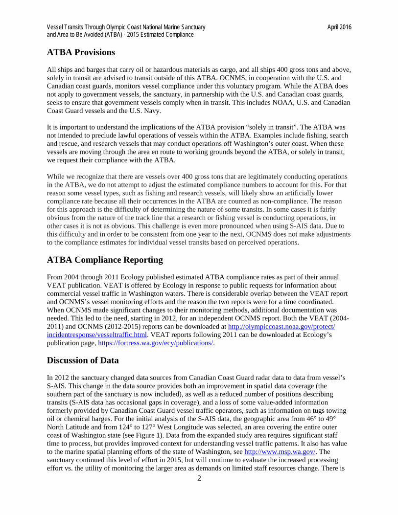
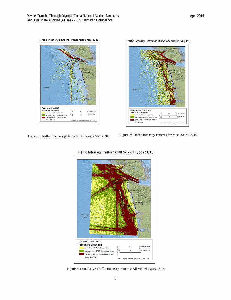
Visual Representation of Data In 2013, OCNMS introduced annual Traffic Intensity Pattern (TIP) maps. To facilitate ease in analysis, the maps use six vessel classes as opposed to the 20 vessel types shown in Table 1. These density maps represent all vessels with an S-AIS transponder that have transited Washington’s outer coast, regardless of tonnage. For this reason, care should be taken in comparing the estimated ATBA compliance rates (Table 2), which only include vessels 400 GT or larger, with the TIP maps (Figures 2-8). S-AIS data are provided as points along a vessel transit. The point data include vessel identification, vessel location and a date/time stamp for monitoring the vessel movement. The number of points included in any vessel transit is related to the number of satellites that capture the AIS signal from the vessel transponder and the speed of the vessel as it moves through the area of interest. In the current satellite configuration there are occasional data coverage gaps. In the 2013 and 2014 TIP maps, the area of interest was divided into 1 km2 grid cells, and the number of unique vessel transits, as represented by individual S-AIS points, was counted for each grid. The grid values were then binned by three traffic intensity classes, representing a relative measure of low, medium and heavy traffic use zones. In the development of a marine spatial plan, Washington State has adopted hexagons (1 mile2) as their unit of analysis. In order to have our vessel traffic data be more compatible with Washington’s marine spatial planning efforts, we have changed from our original 1 km2 grid cell to the grid configuration adopted by Washington State. Since 1 mile2 is approximately equal to 2.6 km2, this change results in a coarser resolution TIP analysis, but one that has better application to WA State MSP and other partner needs. Vessel patterns for the heavy use vessel traffic zones are readily visible in the density maps. The medium and low density zones, however, show the limitation of using intermittent or infrequent S-AIS data as the only source of vessel transit information. Vessel transits have ‘gaps’ evidenced by cells that do not have a recorded data point. Illustration of transit patterns could be improved by additional satellite coverage or the use of terrestrial AIS stations, which would better represent transits in lower density areas. Denser point data would also allow the creation of line transits for vessel density tracking, further improving compliance estimates and expanding the utility of these products for coast-wide applications.

Vessel Transits Through Olympic Coast National Marine Sanctuary April 2016 and Area to Be Avoided (ATBA) - 2015 Estimated Compliance
6
Figure 2: Traffic Intensity Patterns for Cargo Ships, 2015
Figure 3: Traffic Intensity Patterns for Tugs, 2015
Figure 4: Traffic Intensity Patterns for Tankers, 2015
Figure 5: Traffic Intensity Patterns for Fishing Vessels, 2015
Vessel Transits Through Olympic Coast National Marine Sanctuary April 2016 and Area to Be Avoided (ATBA) - 2015 Estimated Compliance
7
Figure 6: Traffic Intensity patterns for Passenger Ships, 2015
Figure 7: Traffic Intensity Patterns for Misc. Ships, 2015
Figure 8: Cumulative Traffic Intensity Patterns: All Vessel Types, 2015

Vessel Transits Through Olympic Coast National Marine Sanctuary April 2016 and Area to Be Avoided (ATBA) - 2015 Estimated Compliance
8
Figure 9: ATBA Information Flyer – Page 1; shows boundary and explains to which vessels it applies.

Vessel Transits Through Olympic Coast National Marine Sanctuary April 2016 and Area to Be Avoided (ATBA) - 2015 Estimated Compliance
9
Figure 10: ATBA Information Flyer – Page 2; provides rationale for ATBA and information on OCNMS.