vhhh ad 2.22 flight procedures - hkatc.gov.hk
TRANSCRIPT

AD2-25 AIP HONG KONG 4 June 2009
Civil Aviation Department Hong Kong
VHHH AD 2.22 FLIGHT PROCEDURES
1. ATC Clearance, Engine Start-Up and Push-back Procedures
1.1 All aircraft, other than helicopters and locally based light aircraft, shall obtain an ATC clearance prior to engine start. Pilots are to inform Hong Kong Ground/Delivery, as appropriate, of the following:
a) callsign,
b) parking stand number/location,
c) Identifier of the latest ATIS received unless it has been included in the RCD (request for departure clearance downlink) message via data link,
d) proposed flight level if it is different from the filed flight plan, and
e) when applicable, special requirements (eg request for another departure runway or inability to comply with SID climb profile).
Additionally, departures for destinations in China routeing via BEKOL (A461) shall contact Hong Kong Delivery 15 minutes before estimated off-block time (EOBT) to obtain advance notification of any flow control restriction that may affect the flight.
1.2 A 2-way Pre-Departure Clearance (PDC) data-link service is available to approved operators from Hong Kong Delivery between 2330 and 1630 UTC daily. Pilots should send a ‘Request for Departure Clearance Downlink’ (RCD) message to ATC not more than 20 minutes prior to EOBT. If the CLD message is not received within 5 minutes or there is any problem with data link exchanges, the pilot shall inform Hong Kong Delivery on frequency 129.9 MHz.
1.3 Pilots not participating in the PDC service shall contact Hong Kong Delivery on frequency 129.9 MHz between 2330 and 1630 UTC. All pilots shall contact Hong Kong Ground on frequency 122.55 MHz between 1630 and 2330 UTC 5 minutes prior to start to put their ATC clearance on request. Upon receipt of the ATC clearance the pilot shall read back the following information:
f) aircraft callsign,
g) destination,
h) route,
i) SID and
j) transponder code.
1.4 Pilots shall comply with instructions issued by Hong Kong Delivery regarding when to contact the relevant Hong Kong Ground frequency.
1.5 Once an ATC clearance has been received, unless there is a specific time restriction included in the clearance, any delay in being ready to push-back, start engines or taxi may result in the clearance being cancelled.
1.6 Pilots shall contact Hong Kong Ground on frequency 122.55 MHz except when notified it is sectorised in which case pilots shall contact: (a) Hong Kong Ground (North) for North and West Aprons on frequency 121.6 MHz; (b) Hong Kong Ground (South) for South, Cargo and Business Aviation Aprons on
frequency 122.55 MHz.
1.7 Aircraft should not commence start-up, push-back, or any other manoeuvre on the apron, unless they have obtained approval from the relevant Hong Kong Ground.

AD2-2622 October 2009 AIP HONG KONG
Civil Aviation Department Hong Kong
1.8 Prior to requesting for push back or taxi from a parking stand, pilots of aircraft
equipped with a ‘weight-on-wheel’ switch must ensure the transponder is operating
(on ‘AUTO’ or ‘XPNDR’, and not ‘STDBY’ or ‘OFF’) and the assigned Mode A code is
selected. Aircraft with Mode S transponder capable of reporting Aircraft Identification
should have its identification in the ICAO flight plan format entered via FMS or Control
Panel.
1.9 The majority of parking stands have two standard push-back procedures, Push-back
BLUE and Push-back RED. The normal push-back procedure is to the taxi lane
abeam the adjacent parking stand, but where this would result in the aircraft entering
a critical area the push-back is extended to a Tug Stop Point clear of the critical area.
A limited number of parking stands have a Push-back/Tow-forward procedure, Push-
back GREEN. (The push-back procedures for each parking stand are shown on
pages AD2-VHHH-99A to AD2-VHHH-99C for passenger aprons and on AD2-99D for
the cargo apron.)
1.10 Under certain traffic conditions it may be necessary for Hong Kong Ground to issue
non-standard push-back instructions to expedite the flow of traffic. Pilots will be
issued a ‘non-standard push-back’ to a defined location and direction.
1.11 Pilots shall ensure that the push-back colour code or non-standard push-back
instructions issued by Hong Kong Ground are accurately relayed to their ground crew
before push-back or engine start commences.
1.12 There is a restriction to the starting of engines for aircraft in parking stands S103,
S108 and W123. If aircraft in these stands are required to push-back through 180º,
only one engine shall be started during the push-back, other engines shall only be
started when the push-back manoeuvre has been completed.
1.13 When known conditions exist which necessitate that engine start-up is carried out in
the parking stand prior to the commencement of push-back, or greater than idle
engine thrust will be required during engine start, (eg cross-bleed start procedure),
the pilot shall advise Hong Kong Ground of the fact when engine start or push-back
clearance is requested.
1.14 Whilst push-back procedure is being conducted it is essential for safety reasons that
communication contact is maintained between pilot and ground engineer in charge.
ATC clearance will not normally be issued to aircraft whilst being pushed back, unless
the pilot so requests.
1.15 To avoid delay to other traffic using the apron aircraft should be ready to taxi as soon
as the push-back manoeuvre and engine start procedure are completed. The
standard push-back for stands N68 and N70 is onto TWY B. Therefore to avoid
delays to other traffic it is essential that the aircraft should be ready to taxi as soon as
the push-back manoeuvre is complete. If aircraft are unable to comply with these
procedures pilots shall immediately inform Hong Kong Ground in order that
alternative taxi instructions may be issued to other traffic.
1.16 Pilots are reminded that they should always use minimum power when starting
engines or manoeuvring within the apron area. It is especially important when
commencing to taxi that break-away thrust is kept to an absolute minimum and then
reduced to idle thrust as soon as practicable.

AD2-27AIP HONG KONG 22 November 2007
Civil Aviation Department Hong Kong
2. Standard Instrument Departures (SIDs)
2.1 GENERAL
2.1.1 RNAV(GNSS) SID procedures and conventional SID procedures follow very similar tracks and use the same set of SID identifications. See pages AD2-VHHH-97A to 97P for details of the SID procedures.
2.1.2 RNAV(GNSS) SID may be flown by compliant aircraft (see page GEN 1.5-2, para 3.5). Carriage of a certified GNSS receiver is mandatory.
2.1.3 Non-compliant aircraft (aircraft that do not have RNP 1/P-RNAV approval or aircraft whose RNP-1/P-RNAV capability has been degraded before departure) shall fly the alternative conventional departure procedure. If radar assistance will be required due to the unserviceability of aircraft equipment or navigation aids, the pilot should inform Hong Kong Ground prior to departure and request radar assistance from Hong Kong Departure when airborne.
2.1.4 Due to the proximity of the FIR boundary to the west, pilots departing RWY 25L or RWY 25R are advised to maintain a careful cross-check of aircraft position after passing PRAWN. In the event of any weather avoidance manoeuvre, permission must be obtained from ATC prior to making any turn away from the prescribed departure track.
2.2 TERRAIN CLEARANCE
2.2.1 To maintain terrain clearance on the appropriate SID the following procedures must be applied to, unless directed by ATC.
Runway Flyover Point Rate of Climb
(under normal operating conditions)
RWY 07L Do not turn right before passing ROVER
4.1% or 250 ft/NM until passing 1 400 ft
RWY 07R Do not turn right before passing PORPA
4.9% or 298 ft/NM until passing 1 400 ft
RWY 25L/25R Do not turn left before passing PRAWN
3.3% or 201 ft/NM
2.3 SPEED CONTROL
2.3.1 RWY 07L/07R departures shall not exceed a speed of 220 KIAS until established on track to RAMEN or TD DVOR.
2.3.2 RWY 25L/25R departures shall not exceed a speed of 230 KIAS until established on track to RUMSY.
2.4 CLIMB REQUIREMENT
2.4.1 To ensure separation of SID routes from STAR routes, aircraft on LAKES B/D or OCEAN B/D SIDs must cross TROUT at or above FL 140. Pilots unable to comply with this requirement must inform ATC as soon as possible so that alternative action can be taken.
2.4.2 To avoid confliction with traffic in the Guangzhou FIR, aircraft on BEKOL SIDs must cross BEKOL at 4 800 m or above. Track distance from take-off to BEKOL is approximately 48 NM. Pilots unable to comply with this requirement must inform Hong Kong ATC prior to departure.

AD2-2819 November 2009 AIP HONG KONG
Civil Aviation Department Hong Kong
2.5 LOSS OF COMMUNICATION
2.5.1 In the event of a loss of communication aircraft shall comply with the last acknowledged clearance up to the next reporting point/waypoint in the SID/Transition procedure listed in para.5.2, then climb to the flight planned cruising level and follow the SID/Transition track to the TMA exit point.
3. Terminal Transition Routes
3.1 Within the Hong Kong TMA a number of Terminal Transition Routes are established. Operators departing from Hong Kong International Airport shall flight plan via the relevant Terminal Transition Route until exiting the Hong Kong TMA to join the appropriate ATS route. (See table ENR 3.1-8 and chart page AD2–85.)
4. SID Navigation Aids
Navaid Frequency Co-ordinates
CH DVOR 112.3 MHz 22 13 10.35 N 114 01 48.20 E
CH DME CH 70X 22 13 11.69 N 114 01 48.75 E
LC NDB 390 kHz 22 17 43 N 113 53 43 E
NLG DVOR 117.7 MHz 22 31 54 N 113 33 48 E
NLG DME CH 124X 22 31 54 N 113 33 48 E
SMT DVOR 114.8 MHz 22 20 15.43 N 113 58 55.46 E
SMT DME CH 95X 22 20 15.43 N 113 58 55.46 E
TD DVOR 116.1 MHz 22 14 52.42 N 114 17 35.30 E
TD DME CH 108X 22 14 52.42 N 114 17 35.30 E
5. SID Locations
5.1 SID FLYOVER WAYPOINTS
Flyover
Waypoint Co-ordinates
Cross Reference from Navaid
RW07L
(RWY 07L DER)22 19 21.08N 113 56 02.35E
IZSL ILS DME 2.0 NM SMT RDL 253/DME 2.8 NM
RW25R
(RWY 25R DER) 22 18 34.27N 113 53 37.06E
ITFR ILS DME 2.0 NM SMT RDL 253/DME 5.2 NM
PORPA 22 20 09.10N 114 01 16.30EISR ILS DME 7.0 NM
LKC RDL 110/DME 8.1 NM
PRAWN 22 16 05.40N 113 48 40.10EIFL ILS DME 7.0 NM
SMT RDL 248/DME 10.4 NM
ROVER 22 20 35.58N 114 01 39.12EIZSL ILS DME 7.3 NM
SMT RDL 085/DME 2.6 NM

AD2-29AIP HONG KONG 19 November 2009
Civil Aviation Department Hong Kong
5.2. SID REPORTING POINTS / FLYBY WAYPOINTS
Reporting Point /
Flyby Waypoint Co-ordinates Cross Reference from Navaid
CH RDL 193 / DME 69.1 NMALLEY 21 05 11.2N 113 47 09.5E
TD RDL 204 / DME 75.0 NM
CH RDL 060 / DME 22.9 NMATENA 22 24 39.85N 114 23 11.88E
TD RDL 030 / DME 11.1 NM
CH RDL 019 / DME 20.2 NMBEKOL 22 32 36.00N 114 08 00.00E
TD RDL 335 / DME 19.8 NM
CH RDL 179 / DME 26.4 NMBREAM 21 46 46.00N 114 03 28.00E
TD RDL 207 / DME 30.9 NM
CH RDL 113 / DME 16.9 NMCOLEY 22 06 41.03N 114 18 37.63E
TD RDL 175 / DME 8.2 NM
CH RDL 229 / DME 145.0 NMDONKI 20 32 58.0N 112 09 10.1E
TD RDL 232 / DME 157.1 NM
CH RDL 108 / DME 51.1 NMLAKES 21 58 41.30N 114 54 38.60E
TD RDL117 / DME 38.0 NM
CH RDL 183 / DME 76.6 NMLEMON 20 56 16.6N 114 00 05.1E
TD RDL 194 / DME 80.0 NM
CH RDL 103 / DME 70.4 NMLOGAN 21 59 16.17N 115 16 08.46E
TD RDL 108 / DME 56.6 NM
CH RDL 121 / DME 50.0 NMOCEAN 21 48 43.00N 114 48 48.00E
TD RDL 134 / DME 39.0 NM
CH RDL 182 / DME 46.7 NMPECAN 21 26 20.2N 114 02 05.6E
TD RDL 199 / DME 50.5 NM
CH RDL 140 / DME 4.7 NMRAMEN 22 09 39.22N 114 05 09.89E
TD RDL 248 / DME 12.6 NM
CH RDL 111 / DME 76.9 NMRASSE 21 47 34.50N 115 19 49.10E
TD RDL 117 / DME 63.9 NM
CH RDL 239 / DME 15.0 NMRUMSY 22 04 56.94N 113 48 16.79E
TD RDL 252 / DME 28.9 NM
CH RDL 154 / DME 21.2 NMSAMON 21 54 23.73N 114 12 32.95E
TD RDL 195 / DME 20.9 NM
SHELY 22 05 26.65N 114 39 13.94E TD RDL 117 / DME 22.2 NM
CH RDL 125 / DME 74.5 NMSKATE 21 31 55.00N 115 08 40.00E
TD RDL 134 / DME 64.0 NM
CH RDL 205 / DME 188.8 NMSURFA 19 18 51.0N 112 44 11.2E
TD RDL 209 / DME 196.5 NM
CH RDL 180 / DME 32.6 NMTITAN 21 40 27.4N 114 03 02.5E
TD RDL 204 / DME 36.9 NM
CH RDL 154 / DME 28.5 NMTROUT 21 47 54.87N 114 16 12.74E
TD RDL 185 / DME 26.9 NM
CH RDL 190 / DME 25.9 NMTD RDL 216 / DME 32.9 NMTUNNA 21 47 25.00N 113 57 54.00E
NLG RDL 155 / DME 49.7 NM
AD2-3022 October 2009 AIP HONG KONG
Civil Aviation Department Hong Kong
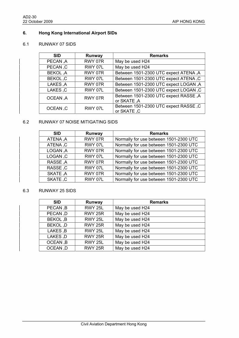
6. Hong Kong International Airport SIDs
6.1 RUNWAY 07 SIDS
SID Runway Remarks
PECAN nA RWY 07R May be used H24
PECAN nC RWY 07L May be used H24
BEKOL nA RWY 07R Between 1501-2300 UTC expect ATENA nA
BEKOL nC RWY 07L Between 1501-2300 UTC expect ATENA nC
LAKES nA RWY 07R Between 1501-2300 UTC expect LOGAN nA
LAKES nC RWY 07L Between 1501-2300 UTC expect LOGAN nC
OCEAN nA RWY 07R Between 1501-2300 UTC expect RASSE nAor SKATE nA
OCEAN nC RWY 07L Between 1501-2300 UTC expect RASSE nCor SKATE nC
6.2 RUNWAY 07 NOISE MITIGATING SIDS
SID Runway Remarks
ATENA nA RWY 07R Normally for use between 1501-2300 UTC
ATENA nC RWY 07L Normally for use between 1501-2300 UTC
LOGAN nA RWY 07R Normally for use between 1501-2300 UTC
LOGAN nC RWY 07L Normally for use between 1501-2300 UTC
RASSE nA RWY 07R Normally for use between 1501-2300 UTC
RASSE nC RWY 07L Normally for use between 1501-2300 UTC
SKATE nA RWY 07R Normally for use between 1501-2300 UTC
SKATE nC RWY 07L Normally for use between 1501-2300 UTC
6.3 RUNWAY 25 SIDS
SID Runway Remarks
PECAN nB RWY 25L May be used H24
PECAN nD RWY 25R May be used H24
BEKOL nB RWY 25L May be used H24
BEKOL nD RWY 25R May be used H24
LAKES nB RWY 25L May be used H24
LAKES nD RWY 25R May be used H24
OCEAN nB RWY 25L May be used H24
OCEAN nD RWY 25R May be used H24
AD 2 - 31 AIP HONG KONG 19 November 2009
Civil Aviation Department Hong Kong
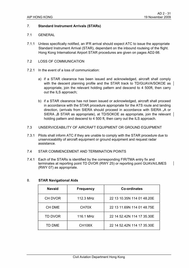
7. Standard Instrument Arrivals (STARs)
7.1 GENERAL
7.1.1 Unless specifically notified, an IFR arrival should expect ATC to issue the appropriate
Standard Instrument Arrival (STAR), dependant on the inbound routeing of the flight.
Hong Kong International Airport STAR procedures are given on pages AD2-98.
7.2 LOSS OF COMMUNICATION
7.2.1 In the event of a loss of communication:
a) if a STAR clearance has been issued and acknowledged, aircraft shall comply
with the descent planning profile and the STAR track to TD/GUAVA/SOKOE as
appropriate, join the relevant holding pattern and descend to 4 500ft, then carry
out the ILS approach;
b) if a STAR clearance has not been issued or acknowledged, aircraft shall proceed
in accordance with the STAR procedure appropriate for the ATS route and landing
direction, (arrivals from SIERA should proceed in accordance with SIERA nA or
SIERA nB STAR as appropriate), at TD/SOKOE as appropriate, join the relevant
holding pattern and descend to 4 500 ft, then carry out the ILS approach.
7.3 UNSERVICEABILITY OF AIRCRAFT EQUIPMENT OR GROUND EQUIPMENT
7.3.1 Pilots shall inform ATC if they are unable to comply with the STAR procedure due to unserviceability of aircraft equipment or ground equipment and request radar assistance.
7.4 STAR COMMENCEMENT AND TERMINATION POINTS
7.4.1 Each of the STARs is identified by the corresponding FIR/TMA entry fix and terminates at reporting point TD DVOR (RWY 25) or reporting point GUAVA/LIMES (RWY 07) as appropriate.
8. STAR Navigational Aids
Navaid Frequency Co-ordinates
CH DVOR 112.3 MHz 22 13 10.35N 114 01 48.20E
CH DME CH70X 22 13 11.69N 114 01 48.75E
TD DVOR 116.1 MHz 22 14 52.42N 114 17 35.30E
TD DME CH108X 22 14 52.42N 114 17 35.30E

AD2-3219 November 2009 AIP HONG KONG
Civil Aviation Department Hong Kong
9. STAR Reporting Points
Reporting Point Co-ordinates Cross Reference from
Navaid
ACORN 20 17 35.0N 114 44 06.0E CH RDL 163/DME 121.7 NM
TD RDL 170/DME 119.4 NM
ABBEY 22 16 11.00N 114 55 25.92E CH RDL 089/DME 49.8 NM
TD RDL 090/DME 35.1 NM
BAKER 21 13 02.0N 114 39 07.0E CH RDL 152/DME 69.3 NM TD RDL 164/DME 64.8 NM
BORDA 21 41 32.4N 113 24 29.0E CH RDL 230/DME 46.9 NM
TD RDL 238/DME 59.5 NM
CANTO 21 39 02.6N 113 42 25.1E CH RDL 210/DEM 38.5 NM
TD RDL 225/DME 48.4 NM
CHERY 20 22 49.0N 115 04 57.0E CH RDL 153/DME 124.8 NM TD RDL 160/DME 120.1 NM
*DOTMI 22 43 06N 116 10 06E CH RDL 078/DME 122.5 NM TD RDL 077/DME 107.9 NM
*DUMOL 19 00 00N 114 26 48E CH RDL 175/DME 193.9 NM TD RDL 179/DME 194.4 NM
*ELATO 22 20 00N 117 30 00E CH RDL 089/DME 193.2 NM TD RDL 090/DME 178.5 NM
CH RDL 089/DME 72.8 NM FISHA 22 16 57.64N 115 20 11.61E
TD RDL 090/DME 58.1 NM
GAMBA 21 19 08.1N 112 55 36.2E CH RDL 231/DME 81.8 NM
TD RDL 236/DME 94.4 NM
GOODI 22 04 09.9N 113 59 48.6E CH RDL 194/DME 9.2 NM
TD RDL 239/DME 19.7NM
GUAVA 22 09 36.1N 114 03 36.3E CH RDL 157/DME 3.9 NM TD RDL 250/DME 14.0 NM
*IDOSI 19 00 00N 112 30 00E CH RDL 205/DME 210.8 NM TD RDL 210/DME 218.8 NM
MANGO 21 36 49.0N 114 30 53.0E CH RDL 145/DME 45.2 NM TD RDL 164/DME 39.9 NM
MAPLE 21 22 26.8N 113 05 42.8E CH RDL 228/DME 72.7 NM
TD RDL 234/DME 84.9 NM
MONTY 22 10 06.3N 114 19 15.7E CH RDL 103/DME 16.5 NM
TD RDL 164/DME 5.0 NM
MURRY 21 45 28.4N 113 48 42.0E CH RDL 206/DME 30.2 NM
TD RDL 225/DME 39.7 NM
MUSEL 22 15 53.99N 114 46 52.13E TD RDL 090/DME 27.2 NM
* STAR commencement point

AD 2 - 33 AIP HONG KONG 19 November 2009
Civil Aviation Department Hong Kong
Reporting Point Co-ordinates Cross Reference from
Navaid
*NOMAN 20 00 00N 116 40 18E CH RDL 133/DME 198.9 NM TD RDL 137/DME 189.4 NM
ROBIN 21 02 45.0N 114 16 06.0E CH RDL 171/DME 71.4 NM TD RDL 183/DME 71.9 NM
ROCCA 21 31 55.4N 113 34 51.4E CH RDL 214/DME 48.1 NM TD RDL 225/DME 58.4 NM
*SABNO 18 59 06N 115 50 42E CH RDL 154/DME 218.7 NM TD RDL 158/DME 213.7 NM
*SIERA 21 59 12N 113 33 12E CH RDL 244/DME 30.0 NM TD RDL 251/DME 44.1 NM
*SIKOU 20 50 36N 111 30 00E CH RDL 242/DME 163.7 NM TD RDL 244/DME 177.4 NM
SILVA 21 51 04.5N 113 54 10.9E CH RDL 200/DME 23.1 NM
TD RDL 225/DME 32.2 NM
TAMAR 22 15 21N 114 30 37E TD RDL 090/DME 12.1 NM
TD 22 14 52.42N 114 17 35.30E
* STAR commencement point

AD2-45AIP HONG KONG 3 June 2010
Civil Aviation Department Hong Kong
18. Instrument Landing System (ILS) - General
18.1 RWY 07L, RWY 07R and RWY 25L ILS are equipped for CAT II landings. RWY 25R
ILS is equipped for CAT IIIA landings. Operators must obtain approval prior to
conducting CAT II/IIIA operations, (see page AD.1.1-3). Pilots wishing to make an ILS
CAT II/IIIA approach shall notify Approach Control on initial contact.
18.2 The standard instrument approach at Hong Kong International Airport is the ILS
approach procedure. Therefore the Arrival ATIS will not include the type of approach
to be expected when the ILS approach procedure is in use. (When the ILS is not
available, the type of approach to be expected will be specified in the Arrival ATIS.)
18.3 No marker beacons are provided. DME equivalents for Outer Marker Fix (OMF) and
Middle Marker Fix (MMF) with glidepath reference altitudes are established.
18.4 Aircraft unable to receive DME information due to ground or airborne equipment
failure will be provided equivalent DME ranges by the Precision Runway Monitor
(PRM) radar controller (callsign 'Hong Kong Precision') on frequency 133.7 MHz. In
the event of airborne DME receiver failure, pilots must inform ATC prior to
commencing the approach. Range information will be provided at the following
positions:
Positions at which equivalent DME ranges are provided
by PRM controller
ILS Approach Final Approach Point
(FAP)
Outer Marker Fix
(OMF)
RWY 07L IZSL DME 5.3 NM IZSL DME 4 NM
RWY 07R ISR DME 5.3 NM ISR DME 4 NM
RWY 25L IFL DME 14.1 NM IFL DME 4 NM
RWY 25R ITFR DME 14.1 NM ITFR DME 4 NM
18.5 Due to the proximity of the FIR boundary to the west, pilots carrying out RWY 07L or
RWY 07R ILS approach are advised to maintain a careful cross-check of aircraft
position after passing the initial approach fix LIMES by the use of appropriate
navigational aids to ensure the aircraft remains on the prescribed track. In the event
of any weather avoidance manoeuvre, permission must be obtained from ATC prior to
making any turn away from the prescribed track.
18.6 The ILS approach procedures include specific speed restrictions. These speed
restrictions are applicable to aircraft that are radar vectored to join the initial or
intermediate approach as well as aircraft commencing the approach from the initial
approach fix, (RWY 07L/07R IAF LIMES, RWY 25L/25R IAF TD DVOR). Pilots
unable to comply with these speed restrictions should inform ATC prior to
commencing the approach so that alternative action can be taken.
18.7 Pilots are warned that during ILS CAT I operations RWY 07R and RWY 25L GP
signals may be liable to interference from aircraft taxiing in the vicinity of the GP
aerial. Pilots should therefore closely monitor their ILS approach profile and rate of
descent.

AD2-4614 February 2008 AIP HONG KONG
Civil Aviation Department Hong Kong
18.8 Due to terrain some of the ILS LOC and GP signals at Hong Kong International
Airport do not have the standard protected areas. The standard ICAO protected areas
for ILS signal coverage are:
a) LOC signal 17 NM within 35° each side of the course line and 25 NM within
10° each side of the course line;
b) GP signal 10 NM within 8° each side of the centreline.
Pilots are reminded that use of the ILS signals outside of the following coverage
areas may lead to false capture or reverse sense indications:
RWY LOC Coverage Area GP Coverage Area
Standard left of LOC course
RWY 07L 17 NM within 28° right of LOC course and 25 NM within 10° right of the LOC course
Standard left and right of RWY centreline
17 NM within 25° left of LOC course and 25 NM within 10° left of the LOC course
RWY 07R 17 NM within 19° right of LOC course and 25 NM within 10° right of the LOC course
Standard left and right of RWY centreline
17 NM within 28° left of LOC course and 25 NM within 10° left of the LOC course
15 NM within 7° left of RWY centreline
RWY 25L
Standard right of LOC course Standard right of RWY centreline
Standard left of LOC course Standard left of RWY centreline
RWY 25R Between 20 NM - 25 NM within 4° right of LOC course below 5 500 ft
15 NM within 6° right of RWY centreline
18.9 If ground based navigational aids are not available, ATC will provide an alternative clearance or give radar assistance.

AD2- 47AIP HONG KONG 3 June 2010
Civil Aviation Department Hong Kong
19. RWY 07L ILS and LOC Approach
19.1 Requests to proceed direct from a point within the TMA to LIMES for an ILS approach
RWY 07L may be approved subject to traffic.
19.2 RWY 07L ILS and LOC Approach Navigation Aids
Navaid/
IdentFrequency Co-ordinates Remarks
Localizer/IZSL 111.1 MHz 22 19 21.08 N 113 56 02.35 E Course 073º
Glide Path 331.7 MHz 22 18 46.29 N 113 54 01.55 E 3º glide slope
DME/IZSL CH 48X 22 18 46.29 N 113 54 01.55 E Co-located with GP
CH DVOR 112.3 MHz 22 13 10.35 N 114 01 48.20 E
CH DME CH 70X 22 13 11.69 N 114 01 48.75 E Co-located with CH DVOR
LKC DVOR 113.2 MHz 22 22 44.12 N 113 53 01.50 E
LKC DME CH 79X 22 22 44.12 N 113 53 01.50 E Co-located with LKC DVOR
NLG DVOR 117.7 MHz 22 31 54 N 113 33 48 E
NLG DME CH 124X 22 31 54 N 113 33 48 E Co-located with NLG DVOR
SMT DVOR 114.8 MHz 22 20 15.43 N 113 58 55.46 E
SMT DME CH 95X 22 20 15.43 N 113 58 55.46 E Co-located with SMT DVOR
TD DVOR 116.1 MHz 22 14 52.42 N 114 17 35.30 E
TD DME CH 108X 22 14 52.42 N 114 17 35.30 E Co-located with TD DVOR
19.3 RWY 07L ILS Approach Significant Points
SignificantPoint
Co-ordinates Cross Reference from Navaid
LIMES 22 06 25.60 N 113 46 32.60 E NLG RDL 157/DME 28.0 NM
CH RDL 247/DME 15.7 NM
TONIC 22 12 47.88 N 113 43 21.85 E NLG RDL 157/DME 21.0 NM
IF IZSL DME 8.3 NM
FAP IZSL DME 5.3 NM
DEDEE 22 23 12.70 N 114 01 03.67 E SMT RDL 036/DME 3.5NM
LINGI 22 25 17.63 N 114 02 34.10 E SMT RDL 036/DME 6.0NM
SAMPU 22 25 39.19 N 114 15 40.91 E TD RDL 353/DME 10.9 NM

AD2-483 June 2010 AIP HONG KONG
Civil Aviation Department Hong Kong
19.4 RWY 07L LOC Approach Significant Points
Significant Point
Co-ordinates Cross Reference from Navaid
LIMES 22 06 25.60 N 113 46 32.60 E NLG RDL 157/DME 28.0 NM CH RDL 247/DME 15.7 NM
TONIC 22 12 47.88 N 113 43 21.85 E NLG RDL 157/DME 21.0 NM
IF IZSL DME 8.5 NM
FAF IZSL DME 6.0 NM
MAPT IZSL DME 0.2 NM
DEDEE 22 23 12.70 N 114 01 03.67 E SMT RDL 036/DME 3.5 NM
LINGI 22 25 17.63 N 114 02 34.10 E SMT RDL 036/DME 6.0 NM
SAMPU 22 25 39.19 N 114 15 40.91 E TD RDL 353/DME 10.9 NM
19.5 RWY 07L ILS and LOC Approach
See AD2-93 A and B for procedure details.
20. RWY 07L VOR Approach
20.1 Requests to proceed direct from a point within the TMA to LIMES for a VOR approach RWY
07L may be approved subject to traffic.
20.2 RWY 07L VOR Approach Navigation Aids
Navaid/
Ident
Frequency Co-ordinates Remarks
CH DVOR 112.3 MHz 22 13 10.35 N 114 01 48.20 E
CH DME CH 70X 22 13 11.69 N 114 01 48.75 E Co-located with CH DVOR
NLG DVOR 117.7 MHz 22 31 54 N 113 33 48 E
NLG DME CH 124X 22 31 54 N 113 33 48 E Co-located with NLG DVOR
SMT DVOR 114.8 MHz 22 20 15.43 N 113 58 55.46 E
SMT DME CH 95X 22 20 15.43 N 113 58 55.46 E Co-located with SMT DVOR
TD DVOR 116.1 MHz 22 14 52.42 N 114 17 35.30 E
TD DME CH 108X 22 14 52.42 N 114 17 35.30 E Co-located with TD DVOR
20.3 RWY 07L VOR Approach Significant Points
Significant Point
Co-ordinates Cross Reference from Navaid
LIMES 22 06 25.60 N 113 46 32.60 E NLG RDL 157/DME 28.0 NM CH RDL 247/DME 15.7 NM
TONIC 22 12 47.88 N 113 43 21.85 E NLG RDL 157/DME 21.0 NM
IF SMT RDL 253/DME 14.0 NM
FAF SMT RDL 253/DME 11.0 NM
MAPT SMT RDL 253/DME 6.5 NM
SOKOE 22 04 41.2 N 113 50 38.1 E TD RDL 250/DME 27.0 NM
20.4 RWY 07L VOR Approach Chart
See chart AD2-VHHH-93C for procedure details.

AD2-49AIP HONG KONG 3 June 2010
Civil Aviation Department Hong Kong
21. RWY 07R ILS and LOC Approach
21.1 Requests to proceed direct from a point within the TMA to LIMES for an ILS approach
RWY 07R may be approved subject to traffic.
21.2 Pilots are warned that RWY 07R GP signals may be liable to interference from aircraft
taxiing in the vicinity of the GP aerial. Pilots should therefore closely monitor their ILS
approach profile and rate of descent.
21.3 RWY 07R ILS and LOC Approach Navigation Aids
Navaid/Ident Frequency Co-ordinates Remarks
Localizer/ISR 109.3 MHz 22 18 29.89 N 113 56 07.90 E Course 073°
Glide Path 332.0 MHz 22 17 47.64 N 113 54 09.59 E 3° glide slope
DME/ISR CH 30X 22 17 47.64 N 113 54 09.59 E Co-located with GP
CH DVOR 112.3 MHz 22 13 10.35 N 114 01 48.20 E
CH DME CH 70X 22 13 11.69 N 114 01 48.75 E Co-located with CH DVOR
LC NDB 390 kHz 22 17 43N 113 53 43E Coverage 10 NM
LKC DVOR 113.2 MHz 22 22 44.12 N 113 53 01.50 E
LKC DME CH 79X 22 22 44.12 N 113 53 01.50 E Co-located with LKC DVOR
NLG DVOR 117.7 MHz 22 31 54 N 113 33 48 E
NLG DME CH 124X 22 31 54 N 113 33 48 E Co-located with NLG DVOR
TD DVOR 116.1 MHz 22 14 52.42 N 114 17 35.30 E
TD DME CH 108X 22 14 52.42 N 114 17 35.30 E Co-located with TD DVOR
21.4 RWY 07R ILS Approach Significant Points
Significant Point Co-ordinates Cross Reference from Navaid
LIMES 22 06 25.60 N 113 46 32.60 E NLG RDL 157/DME 28.0 NM
CH RDL 247/DME 15.7 NM
STELA 22 11 53.29 N 113 43 49.11 E NLG RDL 157/DME 22.0 NM
IF ISR DME 8.3 NM
FAP ISR DME 5.3 NM
PORPA 22 20 09.1 N 114 01 16.3 E ISR DME 7.0 NM
SMT RDL 095/DME 2.2 NM
SOKOE 22 04 41.2 N 113 50 38.1 E TD RDL 250/DME 27.0 NM

AD2-503 June 2010 AIP HONG KONG
Civil Aviation Department Hong Kong
21.5 RWY 07R LOC Approach Significant Points
Significant Point
Co-ordinates Cross Reference from Navaid
LIMES 22 06 25.60 N 113 46 32.60 E NLG RDL 157/DME 28.0 NM CH RDL 247/DME 15.7 NM
STELA 22 11 53.29 N 113 43 49.11 E NLG RDL 157/DME 22.0 NM
IF ISR DME 8.5 NM
FAF ISR DME 6.0 NM
MAPT ISR DME 1.0 NM
PORPA 22 20 09.1 N 114 01 16.3 E ISR DME 7.0 NM SMT RDL 095/DME 2.2 NM
SOKOE 22 04 41.2 N 113 50 38.1 E TD RDL 250/DME 27.0 NM
21.6 RWY 07R ILS and LOC Approach
See AD2-91A and B for procedure details.
22. RWY 25L ILS Approach
22.1 Requests to proceed direct from a point within the TMA to MIRRS for an ILS approach RWY
25L may be approved subject to traffic.
22.2 Pilots are warned that RWY 25L GP signals may be liable to interference from aircraft taxiing
in the vicinity of the GP aerial. Pilots should therefore closely monitor their ILS approach
profile and rate of descent.
22.3 RWY 25L ILS Approach Navigation Aids
Navaid/Ident Frequency Co-ordinates Remarks
Localizer/IFL 108.9 MHz 22 17 43.13 N 113 53 42.80 E Course 253°M
Glide path 329.3 MHz 22 18 19.77 N 113 55 49.30 E 3° glide slope
DME/IFL CH 26X 22 18 19.77 N 113 55 49.30 E Co-located with GP
SMT DVOR 114.8 MHz 22 20 15.43 N 113 58 55.46 E
SMT DME CH 95X 22 20 15.43 N 113 58 55.46 E Co-located with SMT DVOR
TD DVOR 116.1 MHz 22 14 52.42 N 114 17 35.30 E
TD DME CH 108X 22 14 52.42 N 114 17 35.30 E Co-located with TD DVOR
22.4 RWY 25L ILS Approach Significant Points
Significant Point Co-ordinates Cross Reference from Navaid
LOTUS 22 23 18.26 N 114 11 05.60 E IFL DME 15.0 NM
MIRRS 22 24 17.1 N 114 14 09.3 E IFL DME 18.0 NM
PRAWN 22 16 05.4 N 113 48 40.1 E IFL DME 7.0 NM SMT RDL 248/DME 10.4 NM
TD 22 14 52.42 N 114 17 35.30 E

AD2-51AIP HONG KONG 3 June 2010
Civil Aviation Department Hong Kong
22.5 RWY 25L ILS and LOC Approach from 'TD' DVOR
See AD2-92 A and B for procedure Details.
23. RWY 25R ILS Approach
23.1 Requests to proceed direct from a point within the TMA to PLOVE for an ILS
approach RWY 25R may be approved subject to traffic.
23.2 RWY 25R ILS Approach Navigation Aids
Navaid/Ident Frequency Co-ordinates Remarks
Localizer/ITFR 110.9 MHz 22 18 34.27 N 113 53 37.07 E Course 253ºM
Glide path 330.8 MHz 22 19 16.43 N 113 55 35.09 E 3º glide slope
DME/ITFR CH 46X 22 19 16.43 N 113 55 35.09 E Co-located with GP
CH DVOR 112.3 MHz 22 13 10.35 N 114 01 48.20 E
CH DME CH 70X 22 13 11.69 N 114 01 48.75 E Co-located with CH DVOR
LKC DVOR 113.2 MHz 22 22 44.12 N 113 53 01.50 E
LKC DME CH 79X 22 22 44.12 N 113 53 01.50 E Co-located with LKC DVOR
TD DVOR 116.1 MHz 22 14 52.42 N 114 17 35.30 E
TD DME CH 108X 22 14 52.42 N 114 17 35.30 E Co-located with TD DVOR
23.3 RWY 25R ILS Approach Significant Points
Significant Point Co-ordinates Cross Reference from Navaid
PLOVE 22 25 06.30 N 114 13 57.90 E ITFR DME 18.0 NM
RIVER 22 24 07.55 N 114 10 54.23 E ITFR DME 15.0 NM
TD 22 14 52.42 N 114 17 35.30 E
23.4 RWY 25R ILS and LOC Approach
See AD2-94 A and B for procedure details.

AD2-523 June 2010 AIP HONG KONG
Civil Aviation Department Hong Kong
24. RWY 25R VOR Approach
24.1 RWY 25R VOR NAVIGATION AIDS
Navaid/Ident Frequency Co-ordinates Remarks
NLG DVOR 117.7 MHz 22 31 54 N 113 33 48 E
NLG DME CH 124X 22 31 54 N 113 33 48 E Co-located with NLG DVOR
SMT DVOR 114.8 MHz 22 20 15.43 N 113 58 55.46 E
SMT DME CH 95X 22 20 15.43 N 113 58 55.46 E Co-located with SMT DVOR
TD DVOR 116.1 MHz 22 14 52.42 N 114 17 35.30 E
TD DME CH 108X 22 14 52.42 N 114 17 35.30 E Co-located with TD DVOR
24.2 RWY 25R VOR Approach Chart
See AD2-VHHH-94C for procedure details.

AD 2 - 53 AIP HONG KONG 4 June 2009
Civil Aviation Department Hong Kong
25 Procedures for Local Flights in Hong Kong Aerodrome Traffic Zone (ATZ) and
Control Zone (CTR) Zones
25.1 GENERAL
25.1.1 Local flights operating in the Aerodrome Traffic Zone (ATZ) are under the control of
Hong Kong Aerodrome Control. During parallel runway operations the ATZ is split
into two sectors. The Dividing line is mid-way between the two runways - the north
runway (RWY 07L/25R) is under the control of AMC North, operating on frequency
118.2 MHz, call-sign 'Hong Kong Tower North', and the south runway (RWY
07R/25L) is under the control of AMC South, operating on frequency 118.4 MHz,
call-sign 'Hong Kong Tower South'.
25.1.2 Non-IFR flights within the CTR Zones (see chart page AD2-VHHH-102), are under
the control of Hong Kong Zone Control operating on frequency 120.6 MHz, call sign
'Hong Kong Zone'.
25.1.3 Flights within the CTR above 2 000 ft AMSL are under the control of Hong Kong
Approach Control on frequency 119.1 MHz or Departure Control on frequency
123.8 MHz.
25.1.4 To enhance flight safety, it is recommended that all local operators display landing
lights whilst entering, leaving or operating within the ATZ or CTR Zones.
25.2 VERTICAL LIMITS AND ALTITUDE RESTRICTIONS
25.2.1 The vertical limits are:
a) ATZ surface up to 2 000 ft AAL;
b) CTR Zones surface up to 2 000 ft AMSL (subject to paras. 25.2.2 and 25.2.3
below).
25.2.2 In the following CTR Zones ATC will apply an altitude restriction dependant on the
runway in use at Hong Kong International Airport:
CTR Zone RWY in Use Altitude Restriction
South Outer Zone 500 ft
Delta Zone As instructed by ATC
Island Zone routes :
Green Island – Ma Wan Corridor
Green Island – Silvermine
Green Island – Cheung Chau
Green Island – Lamma
Green Island – west of Star Ferry
East of Star Ferry
RWY 07L/R 1 000 ft
800 ft
1 000 ft
1 000 ft
1 000 ft
1 500 ft
South Outer Zone 1 200 ft
Delta Zone RWY 25L/R
As instructed by ATC
AD 2 - 54 30 July 2009 AIP HONG KONG
Civil Aviation Department Hong Kong
25.2.3 In addition, flights requesting to operate in Ma Wan Zone above 500 ft AMSL, Tuen
Mun Zone north of Line B above 1 000ft AMSL and Lantau Zone above 2 000ft AMSL,
including operations at landing sites above these levels, are subject to specific
approval from Hong Kong Zone.
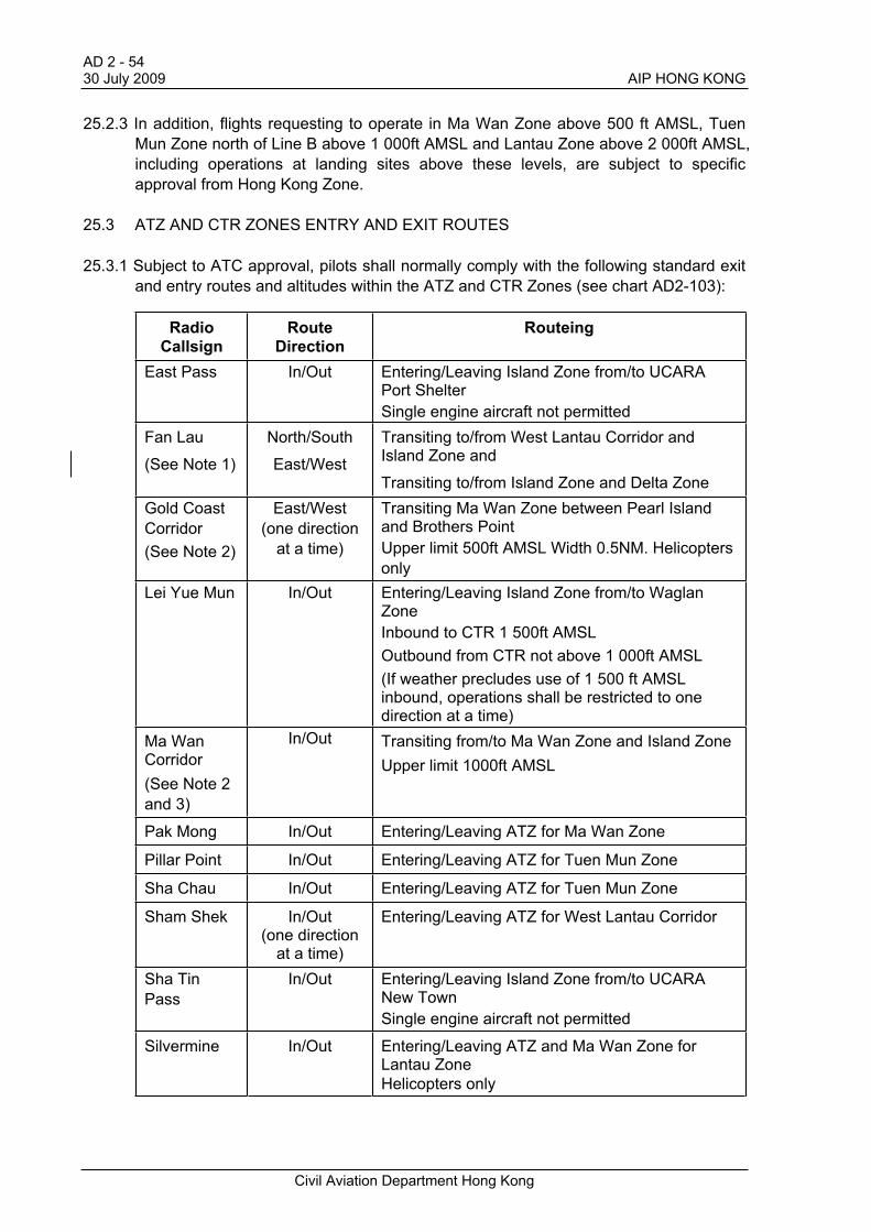
25.3 ATZ AND CTR ZONES ENTRY AND EXIT ROUTES
25.3.1 Subject to ATC approval, pilots shall normally comply with the following standard exit
and entry routes and altitudes within the ATZ and CTR Zones (see chart AD2-103):
Radio
Callsign
Route
Direction
Routeing
East Pass In/Out Entering/Leaving Island Zone from/to UCARA Port Shelter
Single engine aircraft not permitted
Fan Lau
(See Note 1)
North/South
East/West
Transiting to/from West Lantau Corridor and Island Zone and
Transiting to/from Island Zone and Delta Zone
Gold Coast
Corridor
(See Note 2)
East/West
(one direction
at a time)
Transiting Ma Wan Zone between Pearl Islandand Brothers Point
Upper limit 500ft AMSL Width 0.5NM. Helicopters
only
Lei Yue Mun In/Out Entering/Leaving Island Zone from/to Waglan Zone
Inbound to CTR 1 500ft AMSL
Outbound from CTR not above 1 000ft AMSL
(If weather precludes use of 1 500 ft AMSL inbound, operations shall be restricted to one direction at a time)
Ma Wan Corridor
(See Note 2
and 3)
In/Out Transiting from/to Ma Wan Zone and Island Zone
Upper limit 1000ft AMSL
Pak Mong In/Out Entering/Leaving ATZ for Ma Wan Zone
Pillar Point In/Out Entering/Leaving ATZ for Tuen Mun Zone
Sha Chau In/Out Entering/Leaving ATZ for Tuen Mun Zone
Sham Shek In/Out(one direction
at a time)
Entering/Leaving ATZ for West Lantau Corridor
Sha Tin
Pass
In/Out Entering/Leaving Island Zone from/to UCARA New Town
Single engine aircraft not permitted
Silvermine In/Out Entering/Leaving ATZ and Ma Wan Zone for Lantau Zone
Helicopters only
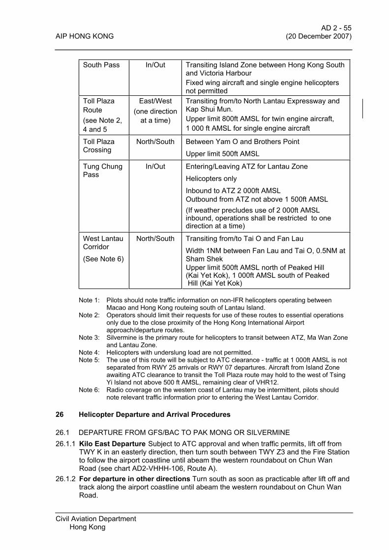
AD 2 - 55 AIP HONG KONG (20 December 2007)
Civil Aviation Department Hong Kong
South Pass In/Out Transiting Island Zone between Hong Kong South and Victoria Harbour
Fixed wing aircraft and single engine helicopters not permitted
Toll Plaza
Route
(see Note 2,
4 and 5
East/West
(one direction
at a time)
Transiting from/to North Lantau Expressway and Kap Shui Mun.
Upper limit 800ft AMSL for twin engine aircraft,
1 000 ft AMSL for single engine aircraft
Toll Plaza Crossing
North/South Between Yam O and Brothers Point
Upper limit 500ft AMSL
Tung Chung Pass
In/Out Entering/Leaving ATZ for Lantau Zone
Helicopters only
Inbound to ATZ 2 000ft AMSL
Outbound from ATZ not above 1 500ft AMSL
(If weather precludes use of 2 000ft AMSL inbound, operations shall be restricted to one direction at a time)
West Lantau Corridor
(See Note 6)
North/South Transiting from/to Tai O and Fan Lau
Width 1NM between Fan Lau and Tai O, 0.5NM at Sham Shek
Upper limit 500ft AMSL north of Peaked Hill(Kai Yet Kok), 1 000ft AMSL south of Peaked Hill (Kai Yet Kok)
Note 1: Pilots should note traffic information on non-IFR helicopters operating between Macao and Hong Kong routeing south of Lantau Island.
Note 2: Operators should limit their requests for use of these routes to essential operations only due to the close proximity of the Hong Kong International Airport approach/departure routes.
Note 3: Silvermine is the primary route for helicopters to transit between ATZ, Ma Wan Zone and Lantau Zone.
Note 4: Helicopters with underslung load are not permitted. Note 5: The use of this route will be subject to ATC clearance - traffic at 1 000ft AMSL is not
separated from RWY 25 arrivals or RWY 07 departures. Aircraft from Island Zone awaiting ATC clearance to transit the Toll Plaza route may hold to the west of Tsing Yi Island not above 500 ft AMSL, remaining clear of VHR12.
Note 6: Radio coverage on the western coast of Lantau may be intermittent, pilots should note relevant traffic information prior to entering the West Lantau Corridor.
26 Helicopter Departure and Arrival Procedures
26.1 DEPARTURE FROM GFS/BAC TO PAK MONG OR SILVERMINE
26.1.1 Kilo East Departure Subject to ATC approval and when traffic permits, lift off from TWY K in an easterly direction, then turn south between TWY Z3 and the Fire Station to follow the airport coastline until abeam the western roundabout on Chun Wan Road (see chart AD2-VHHH-106, Route A).
26.1.2 For departure in other directions Turn south as soon as practicable after lift off and track along the airport coastline until abeam the western roundabout on Chun Wan Road.
AD 2 - 56 (20 December 2007) AIP HONG KONG
Civil Aviation Department Hong Kong
26.1.3 From abeam the western roundabout, track along Chun Wan Road to Cathay City,
then follow the North Lantau Expressway (NLE) to Pak Mong at not above 500 ft
AMSL, remaining over water and a distance of 500 ft from the Lantau coastline (see
chart AD2-VHHH-106, Route B).
26.1.4 Alternatively, from abeam the western roundabout, follow the airport coastline to
overfly Tower 2B of the cable car ropeway, then track over the channel between the
airport island and Lantau, to follow the NLE to Pak Mong at not above 500 ft AMSL,
remaining over water and a distance of 500 ft from the Lantau coastline (see chart
AD2-VHHH-106, Route C).
26.1.5 During Special VFR operations pilots are required to report passing AFFC (radio c/s
‘Freight Centre’) to Hong Kong Tower when departing from the airport.
26.1.6 Helicopters departing from sites at the airport that require to cross the south runway,
e.g. HAECO maintenance area, shall initially route as directed by ATC, then follow
Route A, B or C as appropriate.
26.2 ARRIVALS FROM PAK MONG OR SILVERMINE TO GFS/BAC
26.2.1 Follow the reciprocal of paras. 26.1.3 or 26.1.4 above to AFFC at not above 500 ft
AMSL. From AFFC follow ATC instructions to commence an approach. ATC approval
must be obtained before overflying or landing on TWY K.
26.2.2 Helicopters operating to sites on the airport that require to cross the south runway,
e.g. Temporary Parking Apron, shall initially comply with para 26.2.1 above then the
final approach route will be as directed by ATC.
26.2.3 If holding is required, follow ATC instructions and comply with para 26.3 below.
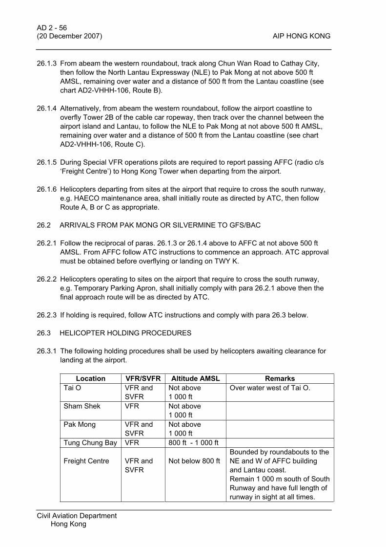
26.3 HELICOPTER HOLDING PROCEDURES
26.3.1 The following holding procedures shall be used by helicopters awaiting clearance for
landing at the airport.
Location VFR/SVFR Altitude AMSL Remarks
Tai O VFR and
SVFR
Not above
1 000 ft
Over water west of Tai O.
Sham Shek VFR Not above
1 000 ft
Pak Mong VFR and
SVFR
Not above
1 000 ft
Tung Chung Bay VFR 800 ft - 1 000 ft
Freight Centre VFR and
SVFR
Not below 800 ft
Bounded by roundabouts to the
NE and W of AFFC building
and Lantau coast.
Remain 1 000 m south of South
Runway and have full length of
runway in sight at all times.

AD2 - 57 AIP HONG KONG (22 November 2007)
Civil Aviation Department Hong Kong
Location VFR/SVFR Altitude AMSL Remarks
Cathay City VFR and
SVFR
Not above 800 ft
Secondary hold when weather
precludes use of Freight Centre
hold.
Remain 1 000 m south of south
runway.
Hold over water between
Cathay City and Tung Chung
Ferry Pier.
27 Helicopter Runway Crossing Procedures
27.1 ROUTES
27.1.1 Helicopters shall cross the runways via one of the two Runway Crossing Corridors –
Runway 25 Crossing Corridor at the eastern boundary of the airport and Runway 07
Crossing Corridor at the western boundary of the airport (see chart AD2-VHHH-105).
Helicopters are not normally permitted to cross over the airport. During parallel
runway operations helicopters are not permitted to hold between the runways.
27.1.2 Runway 25 Crossing Corridor is a direct track between Holding Point ECHO and
Abeam Cathay City, passing over RWY 25L/25R approach lights and east of Sky
City.
27.1.3 Runway 07 Crossing Corridor is a corridor between Holding Point WHISKEY and Sha
Lo Wan, passing over RWY 07L approach lights, west of HAECO hangar and
immediately west of RWY 07R threshold. Helicopters overflying the airport should use
the eastern part of the corridor and helicopters approaching or departing the airport
should use the western part of the corridor.
27.1.4 The recommended altitude for the Runway Crossing Corridors is 800 ft AMSL for
wake turbulence avoidance. Runway 07 Crossing Corridor is wide enough to permit
helicopters approaching or departing the airport to manoeuvre and cross above the
glidepath profile of landing traffic.
27.1.5 ATC will normally issue a conditional crossing clearance with specific instructions to
cross behind landing traffic. Pilots should be aware that there is normally a 5 mile
spacing between arrivals. Once the relevant traffic has been visually identified, pilots
should adjust their speed and track to ensure the crossing is completed with the
minimum of delay after the landing aircraft has passed. Holding between the two
runways is not permitted.
27.1.6 Because of the extra distance involved when crossing the north runway from the
southern holding points, or crossing the south runway from the northern holding
points, once a pilot has received a conditional crossing clearance and the relevant
landing traffic has been positively identified, the helicopter may depart the holding
point and position to cross behind the landing aircraft, but under no circumstances
shall it proceed beyond the centreline of the airport until the landing aircraft has
passed the applicable Crossing Corridor. (The centreline of the airport is taken as the
spine of the Passenger Terminal Building and the north side of the HAECO hangar.)

AD2 - 58 (22 November 2007) AIP HONG KONG
Civil Aviation Department Hong Kong
27.1.7 Pilots unable to comply with these procedures, e.g. when operating with underslung
loads, should provide adequate prior notification to ATC to facilitate alternative plans.
27.2 HELICOPTER HOLDING PROCEDURES FOR RUNWAY CROSSING
27.2.1 The following holding procedures shall be used by helicopters awaiting a runway
crossing:
Location VFR/SVFR Altitude AMSL Remarks
WHISKEY VFR Maximum 1 000 ft Remain at least 1 000 m
north of north runway
ECHO VFR Maximum 1 000 ft Remain at least 1 000 m
north of north runway
Sha Lo Wan VFR Not above 1 000 ftRemain at least 1 000 m
south of south runway
VFR Not above 800 ft Cathay City
SVFR Not above 500 ft
Remain at least 1 000 m
south of south runway
Tai O VFR and
SVFRNot above 1 000 ft
Pillar Point VFR and
SVFRNot above 1 000 ft
Sha Chau VFR and
SVFR500 ft – 1 000 ft
27.2.2 Helicopter holding patterns are right hand orbits with a speed restriction of not more than 70 KIAS.
27.2.3 Helicopters operating SVFR may be subject to extensive delay in waiting to cross the
runways. Therefore runway crossings should be limited to flights of an urgent nature
only. Other flights should consider re-routeing and crossing the extended runway
centre-line via Yam O – Brothers Point route. (When planning a SVFR flight operators
should make allowances for possible holding delays and the alternative routeing.)
28 Rejoining Procedures for Fixed Wing Aircraft
28.1 Three visual holding areas are established over prominent geographical features in
the CTR to assist in the sequencing of VFR flights with other traffic. The holding areas
are:
Location Altitude AMSL Runway in Use Routeing
Green Island
Left hand hold
Maximum 2 000 ft RWY 25 For flights from the south
Soko Island
Left hand hold
Maximum 2 000 ft RWY 07 For flights from the south
Lung Kwu Chau/ Sha Chau
Left hand hold
Maximum 1 500 ft
Maximum 1 000 ft
RWY 07
RWY 25
For flights from the north

AD 2 - 59 AIP HONG KONG 7 June 2007
Civil Aviation Department Hong Kong
28.2 A visual holding pattern is established within the ATZ to assist in the sequencing of
VFR flights with other traffic. Details of the holding pattern are:
Holding Pattern Altitude AMSL Runway in Use
ATZ Hold Left hand hold RWY25
ATZ Hold Right hand hold 1000 ft
RWY 07
29. Procedures for Local Flights in Uncontrolled Airspace Reporting Areas
(UCARAs)
29.1 GENERAL
29.1.1 Special areas have been defined to permit aircraft operations to take place under
VFR. The associated procedures have been developed to allow such flying to take
place without interference to aircraft operating in accordance with IFR and/or in the
Hong Kong Aerodrome Traffic Zone and Control Zone. The six areas are designated
as Uncontrolled Airspace Reporting Areas (UCARAs ): Mirs Bay, North Border, New
Town, Ninepins, Port Shelter and Tolo.
29.1.2 UCARA airspace is classified as Category G with an additional requirement for two-
way radio communication.
29.2 LATERAL LIMITS
29.2.1 The lateral boundaries of the UCARAs are indicated on page AD2-VHHH-102.
29.3 VERTICAL LIMITS
29.3.1 The vertical limits of the UCARAs are :
a) New Town, Port Shelter and Ninepins Surface to 2 000 ft AMSL
b) Mirs Bay and Tolo Surface to 3 000 ft AMSL
c) North Border Surface to 2 000 ft AMSL *
Note * Normally aircraft will be restricted to 1 000 ft AMSL or below. For operations
above 1 000 ft prior permission from Hong Kong ATC is required which will be
subject to co-ordination with Zhuhai ATC.
29.4 FLIGHT NOTIFICATION
29.4.1 Flight notification shall be submitted to Hong Kong Aerodrome Control in accordance
with Regulations for Local Flights in Hong Kong (page AD2-VHHH-17 para 1.1.4).
29.4.2 Aircraft or helicopters landing at Shek Kong aerodrome or any other site in UCARAs
shall report their arrival to 'Hong Kong Information' immediately prior to landing. If no
radio contact is made with 'Hong Kong Information' or if outside the notified hours of
operation, pilots shall report to Hong Kong Aerodrome Control by telephone (tel no
2910 6822) as soon as possible after landing.

AD 2 - 60 22 October 2009 AIP HONG KONG
Civil Aviation Department Hong Kong
29.4.3 Pilots must note that if no landing report is received within 30 minutes of the
estimated time of arrival, alerting action will be initiated by ATC.
29.5 COMMUNICATIONS
29.5.1 Pilots shall establish and maintain two-way communication with 'Hong Kong
Information' on entering and when operating within UCARAs.
29.5.2 Pilots shall report their position and altitude as follows:
a) When entering /leaving each UCARA;
b) Every 15 minutes if no other communication have been made within that period.
29.5.3 When 'Hong Kong Information' is not available, pilots should broadcast their positions
on frequency 122.4 MHz at appropriate intervals and when crossing UCARA
boundaries, for the information of other aircraft in the area.
29.5.4 In order to enhance flight safety in the vicinity of the entry/exit routes to/from the Shek
Kong Aerodrome Reporting Area (SKARA), pilots are to include in their initial
transmission on leaving the SKARA, the name of the entry/exit route, as well as the
UCARA they are entering.
29.6 RADIO COMMUNICATION FAILURE PROCEDURES
29.6.1 Fixed wing aircraft shall proceed to Shek Kong Aerodrome, carry out a standard
joining procedure to the circuit keeping a good look-out whilst making all normal
transmissions. Carry out a standard circuit to land, at all times exercising extreme
caution with respect to other aircraft in the vicinity. After landing pilots are to taxi clear
of the runway and shutdown. Pilots shall contact Hong Kong Aerodrome Control by
telephone (tel. no. 2910 6822) as soon as possible after landing.
29.6.2 Helicopters shall land at a suitable helicopter landing site and pilots shall contact
Hong Kong Aerodrome Control by telephone as soon as possible after landing.
30 Flight Information Service
30.1 Hong Kong Flight Information Service provides a flight information service and an
alerting service between 0900 and sunset, daily, to non-IFR flights operating within
the UCARAs. Between sunset and 0859 local time, alerting service only is available.
The radio call-sign is 'Hong Kong Information' and the frequency is 122.40 MHz
primary and 121.0 MHz secondary.
30.2 It is emphasised that the service offered by Hong Kong Flight Information Service is
an information service only and collision avoidance is entirely the responsibility of the
pilot –in-command. Traffic information will normally be provided to an aircraft only
when it reports entering a UCARA sector or makes a periodic ‘ops normal’ report.
Aircraft already operating within a UCARA are expected to maintain their own traffic
watch between ‘ops normal’ reports by monitoring the FIS frequency for the
transmissions of other aircraft.
AD2-VHHH -61 AIP HONG KONG (7 June 2007)
Civil Aviation Department Hong Kong
30.3 Outside of the hours of operation of Hong Kong Flight Information Service pilots
should make 'blind' transmissions on the Hong Kong Information frequency and
maintain a particularly good look-out for any deterioration of weather conditions.
31 Procedures for Entry and Exit to/from Shek Kong Aerodrome Reporting Area
(SKARA)
31.1 Prior permission must be obtained from the appropriate military authority for any flight
intending to operate within the Shek Kong Aerodrome Reporting Area (SKARA).
(Details of the flight procedures applicable within the SKARA will be provided by the
military authority.)
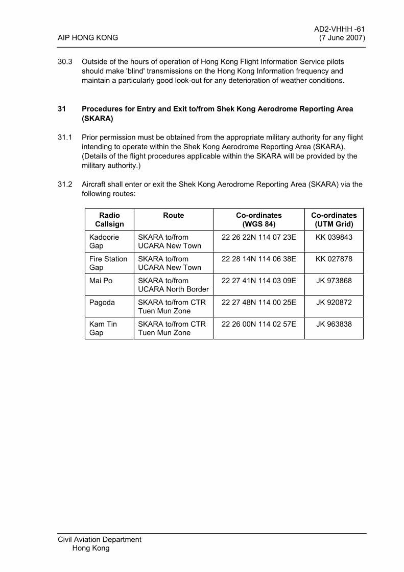
31.2 Aircraft shall enter or exit the Shek Kong Aerodrome Reporting Area (SKARA) via the
following routes:
Radio
Callsign
Route Co-ordinates
(WGS 84)
Co-ordinates
(UTM Grid)
KadoorieGap
SKARA to/from UCARA New Town
22 26 22N 114 07 23E KK 039843
Fire Station Gap
SKARA to/from UCARA New Town
22 28 14N 114 06 38E KK 027878
Mai Po SKARA to/from UCARA North Border
22 27 41N 114 03 09E JK 973868
Pagoda SKARA to/from CTR Tuen Mun Zone
22 27 48N 114 00 25E JK 920872
Kam Tin Gap
SKARA to/from CTR Tuen Mun Zone
22 26 00N 114 02 57E JK 963838
AIP HONG KONG
Civil Aviation Department Hong Kong
(AD2-VHHHH-62 to AD2-VHHHH-74 reserved)