vidyasagar evening college department of · pdf filepaper iib: practical— megascopic...
TRANSCRIPT

VIDYASAGAR EVENING COLLEGE DEPARTMENT OF GEOGRAPHY
ACADEMIC CALENDAR, SESSION-- 2017-2018 CLASS: FIRST YEAR HONOURS (New Syllabus)
DATE OF COMMENCEMENT—24 July, 2017
Weeks Units Topics Teacher No. of classes
1-5
1.1&1.2
1.4
3.1&3.2
1.1&1.2
4.1&4.2
1.1&1.2
1.4
3.1&3.2
1.1&1.2
1.3
PAPER I: MODULE—1: Geotectonics—Origin of the universe with particular reference to Big Bang Theory; Geological time scale and related topographic and structural evolution; Concept of Isostasy postulated by Pratt and Airy; PAPER I: MODULE—1: Geotectonics—Plate Tectonic processes—sea floor spreading, subduction, Geomorphology—Basic concepts of Geomorphology as proposed by W.D.Thornbury; Landforms on Granite and Basalt. MODULE—2: Hydrology—Definition, Scope and content of Hydrology; Global Hydrological cycle--its physical and biological roles. Oceanography—Physical and Chemical properties of ocean water PAPER IIA: MODULE—3: Economic Geography—Concept and classification of resources: Economic and Environmental approaches to resource utilization. Resource depletion and resource conservation; Forrester-Meadows model on Limits to Growth; sustainable use of resources. Global scenario of resource related problems and trend of management with reference to Iron ore, Bauxite, Coal, Petroleum and Nuclear power. Secondary activities: Concept, Classification and importance. Secondary activities: Concept, classification and importance. Factors of industrial location; industrial location and economic growth models—Weber, Losch and Gunner Myrdal. PAPER IIB: MODULE—4: Practical—Scale: Construction of Linear and Diagonal scale; Cartograms: Bar graphs Development of river network and landforms on Uniclinal and Folded structures. Interpretation of Geological Maps.
NR
SK
SKK
RS
JLS
JM
JLS
NR
AM
SND
10
10
10
10
10
10 5 5
30
15
6-12
1.2&1.3 2.1&2.2 2.3 &2.4
1.3&1.4 4.2 &4.4
1.3 &4.2
2.1&2.2
.2&3.3
1.1&1.2
Concept of Isostasy postulated by Pratt and Airy; Folds—Origin, types. Geomorphology— Degradational processes: processes of rock weathering and their effects on landform; Fluvial processes and landforms. Geomorphology—Glacial processes and landforms: Fluvio-Glacial landforms; Aeolian processes and landforms: Fluvio-aeolian processes. Plate Tectonic processes—Orogenesis,,earthquqke and vulcanicity; MODULE—2: Hydrology-- Drainage basin as a hydrological unit; Run off: controlling factors—infiltration, evaporation and transpiration. Oceanography—Coral reefs and atolls: types and factors, coral and volcanic islands; Resource potential of the oceans. PAPER IIA: MODULE—3: Economic Geography—Land as resource: Problems of land acquisition in developing countries; Development of EPZ and SEZ; Land reforms in India with special reference to West Bengal. Trade: as an engine and hindrance to growth, determinants, trade strategies—import substitution and export promotion. Primary activities—: Concept, Classification and importance; World view of problems and trend of management with reference to forestry, fishing and livestock farming. Industrial location and economic growth models—Weber, Losch and Gunner Myrdal. Industries—their resource base, distribution, potentials of growth and problems with reference to Iron and steel (UK, Japan and India) PAPER IIB: Practical— Construction of Linear, Diagonal scale and Vernier scale; Cartograms: Bar graphs. Geological Map interpretation;
CLASS TEST 1 & 2----50 Marks each
NR NR
SKK
SK
RS
JLS
RS
JM
JLS
NR
AM
SND
14 14
12
14
14
14
14
14 7 7
42
21

Continued—page-2 (2017-2018)
CLASS: FIRST YEAR HONOURS
Weeks Units Topics Teacher No. of Classes
13-18
1.4
2.3&2.4
1.3 1.4,2.1&2.2
4.1,3.1 4.1, 3.1
4.1, 4.3
2.3
3.3
1.2
1.3
PAPER I: MODULE—1: Geotectonics—Plate Tectonic processes—Orogenesis, earthquqke and vulcanicity; Geomorphology—Glacial processes and landforms: Fluvio-Glacial landforms; Aeolian processes and landforms: Fluvio-aeolian processes. Folds and Faults—origin, types and their topographic expressions. MODULE—2: Hydrology— Run off cycle; Physical properties of ground water; Chemical properties of ground water. Oceanography: Oceanic sediments: origin and classification; Resource potential of the oceans PAPER IIA: MODULE—3: Economic Geography— Tertiary activities and service: Concept, classification and importance; International trade: Ricardian theory, International trade with reference to GATT and WTO. Critical appreciation of agricultural systems: Intensive agriculture (Rice), Extensive agriculture (Wheat), Plantation farming (Tea) and Mixed farming (NW Europe). Industries—their resource base, distribution, potentials of growth and problems with reference to Cotton textile (USA and India), Petro-chemicals (USA and India) and Food processing (India) PAPER IIB: MODULE—4: Practical—Cartograms—Flow diagrams and Divided proportional Circles Interpretation of Geological Maps.
CLASS TEST 3 & 4---50 Marks each
SK
SKK
NR RS
JLS
JM
JLS
NR
AM
SND
12
12
12 12
12
12
6 6
36
18
19 MID-TERM TEST
20-22
3.3 4.1-4.2
1.3 2.3
3.2,3.3
4.4
2.4 3.4
4.3
1.1—1.3 1.2 1.3
PAPER I: MODULE—1: Geomorphology— Landforms on limestone; Geomorphology— Normal cycle of erosion by W.M.Davis; Views of W.Penck on landform evolution; Faults—origin, types and their topographic expressions. MODULE—2: Hydrology—Components, factors and processes controlling storage and movement of ground water. Oceanography: Concept of water mass—waves, tides and their influence. PAPER IIA: MODULE—3: Economic Geography— Transport: Concept of distance, accessibility and connectivity; relative cost advantage of different modes of transport. Land use and agricultural models—L.D.Stamp, Von Thunen and Weaver. Industrial association, integration, infrastructure and problems with reference to Lake District, Canto Plains and Kolkata-Haldia. Economic Geography—International trade: Ricardian theory, International trade with reference to GATT and WTO PAPER IIB: MODULE—4: Practical— Practice and signature, Interpretation of Geological Maps.
CLASS TEST 5 & 6---50 Marks each. EXCURSION AND FIELD STUDY
SKK
SK NR RS
JLS
RS
JLS NR
JM
AM SND
6 6 6 6 6 6 6 6 6
18 9
23-28
1.1-1.3
4.3—4.4
2.1-2.4 2.1-2.4
3.3,3.4
4.1-4.4 2.1-2.4 3.1-3.4
1.4 1.3
PAPER I: MODULE—1: Geotectonics—Faults and Revision of previous lessons. The concept of Pediplanation as proposed by L.C.King; Dynamic equilibrium theory by J.T.Hack. Revision of previous lessons MODULE—2: Hydrology—Types of aquifers and issues related to their over utilization. Revision of previous lessons. Oceanography: Tides and their influences; Ocean currents and their influence. Revision of previous lessons. PAPER IIA: MODULE—3: —Revision of previous lessons. Revision of previous lessons. Revision of previous lessons. PAPER IIB: Practical— Megascopic identification of rocks and minerals. Interpretation of Geological Maps.
CLASS TEST—5 & 6-- 50 Marks each
NR
SK
SKK RS
JLS
JM JLS NR AM SND
12
12
12 12
12
12 6 6
36 18

Continued—page-3 (2017-2018)
CLASS: FIRST YEAR HONOURS
Head of the Department of Geography
29-30
TEST--First paper (Th)—100 Marks, Second paper Gr. A (Th)—50 Marks, Second paper Gr. B (Pr)—50 Marks
April-June, 2018
Theoretical and Practical Remedial and Tutorial classes PRE-FINAL TEST OF ALL PAPERS AS PER UNIVERSITY EXAM
AM+JLS+ SND
50+30+ 30

VIDYASAGAR EVENING COLLEGE
DEPARTMENT OF GEOGRAPHY ACADEMIC CALENDAR, SESSION-- 2017-2018
CLASS: SECOND YEAR HONOURS
DATE OF COMMENCEMENT: SEPTEMBER, 2017
Weeks Units Topics Teacher No. of classes
1-5
1.1-- 1.3
2.1, 2.2 1.1—1.2
2.1,2.2
2.1,2.2
3.1, 3.2
1.1—1.3
4.1, 4.2
1.1-1.4,2.1
PAPER III: Module-5: Climatology—Nature, composition and layered structure of the atmosphere; Factors affecting insolation; Heat budget of the atmosphere. Horizontal and vertical distribution of temperature. Global atmospheric pressure belts and their oscillation; General wind circulation. Module-6: Soil Geography—Definition and factors responsible for soil formation; Concept of V.V.Dokuchaev—ektodynamomorphic and endodynamomorphic soils; Concept of N.M.Sibirtzev—Zonal, Azonal and Intra Zonal soils; Physical properties of soil—Soil texture, structure and moisture; Chemical properties of soil—Ph, Organic matter and NPK. Soil erosion: Processes and controlling factors; Various measures of soil conservation. Bio-Geography—Scope and content of Bio-Geography; Nature of Biosphere. Concepts of Ecology, Ecosystem and major natural ecosystems—terrestrial and marine; Trophic structure, Food chain, Food web. Paper IVA: Module-7: Social and Cultural Geography—Definition, scope and content of Social Geography; Evolution of Social Geography: Approaches—Possibilistic, Behavioral, Radical and Welfare; Social structure and Social processes—macro and micro; Social patterns. Political Geography: Definition and scope of Political Geography; Approaches and schools of thought in Political Geography—Landscape school, Functional school. PAPER IVB: Module-8: Practical—Topographical Map Interpretation; Survey with instruments—Contouring by leveling along radial line by a Dumpy level
SK
RS
SKK
JM
NR
RS
PG
NR
AM
10
10
10 5 5
10
15 5
40
6-7
STUDY TOUR AND FIELD SURVEY
AM, JLS, X
34
8-13
1.4,3.1 2.3,2.4
1.4
2.3
2.1,2.2
3.3,3.4 1.4,2.1,2.2
4.2,4.3
1.1-1.4,2.3
PAPER III: Module-5: Climatology— Greenhouse effect and importance of ozone layer; Process and forms of condensation. Jet Stream and index cycle; Monsoon mechanism with reference to jet stream. Module-6: Soil Geography— Profile characteristics of Pedalfer group: Laterite and Podzol; Profile characteristics of Pedocal group: Chernozem. Principles of soil classification: Genetic school and USDA; Principles of land classification: UK and USDA. Physical properties of soil—Soil texture, structure and moisture; Chemical properties of soil—Ph, Organic matter and NPK. Bio-Geography— Laws of Thermodynamics; Energy flow in ecosystems. Paper IVA: Module-7: Social and Cultural Geography—Concept of space: Social space and Material space; Social well being; Rgion as a social unit. Social elements; Class, caste and ethnicity with special reference to India. Political Geography: Approaches and schools of thought in Political Geography—Morphological school; Geo-strategic views of Mackinder and Spykeman. PAPER IVB: Module-8: Practical— Topographical Map Interpretation; Survey with instruments—Longitudinal/ Profile leveling by Dumpy level.
CLASS TEST 1,2 & 3—50 Marks each
SK
RS
SKK
NR
JM
RS PG
NR
AM
12
12
12 6 6
12 18
6
48
14 MID-TERM TEST

Continued—page-2 (2017-2018)
CLASS: SECOND YEAR HONOURS
Weeks Units Topics Teacher No. of classes
15-18
3.2, 3.3
1.3
2.3, 2.4
1.4
4.1,4.2
2.3,2.4,3.1
4.4
1.1-1.4,2.4
PAPER III: Module-5: Climatology—Mechanism and forms of precipitation—Ice crystal theory, Collision-coalescence theory. Airmass: typology, origin and characteristics. Tropical cyclone; Mid-latitude cyclone. Module-6: Soil Geography— Profile characteristics of Pedalfer group: Laterite and Podzol; Profile characteristics of Pedocal group: Chernozem. Principles of soil classification: Genetic school and USDA; Principles of land classification: UK and USDA. Land capability classification by Storie Physical properties of soil—Soil texture, structure and moisture; Chemical properties of soil—Ph, Organic matter and NPK. Bio-Geography— Bio-Geo-Chemical cycles; Concept of Biome, ecotone and community; Study of Tropical Rain forest, Taiga biome and Temperate grass lands; Deforestation and its impact on environment, Significance of Biodiversity and controlling factors. PAPER IVA: Module-7: Social and Cultural Geography—Social issues in urban areas: Social area analysis; Social ecology; Social Groups: Tribal, Traditional and Modern society. Concept of culture in Geography: definition, scope and content of Cultural Geography. Political Geography: Political Geography of India: Impact of partition of India. PAPER IVB: Module-8: Practical— Topographical Map Interpretation; Survey with instruments—Longitudinal/ Profile leveling by Dumpy level.
CLASS TEST 4,5 & 6—50 Marks each
SK
RS
SKK
NR
JM
RS
PG
NR
AM
8 8 8 8 4 8
12 4
32
19-20
TEST Third paper (Th)—100 Marks
Fourth paper Gr. A (Th)—50 Marks Fourth paper Gr. B (Pr)—50 Marks
21-23
Revision of previous lessons AM, SK,RS,PG
68
April-May, 2018
Theoretical and Practical Remedial and Tutorial classes Practical remedial and practice classes PRE-FINAL TEST OF ALL PAPERS AS PER UNIVERSITY EXAM
AM JLS
70
Head of the Department of Geography
VIDYASAGAR EVENING COLLEGE DEPARTMENT OF GEOGRAPHY
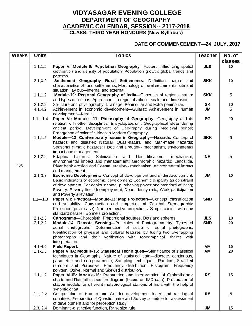
ACADEMIC CALENDAR, SESSION-- 2017-2018 CLASS: THIRD YEAR HONOURS (New Syllabus)
DATE OF COMMENCEMENT—24 JULY, 2017
Weeks Units Topics Teacher No. of classes
1-5
1.1,1.2
3.1,3.2
1.1,1.2
2.1,2.2 4.1,4.2
1.1—1.4
1.1,1.2
2.1,2.2
3.1-3.3
1.1—1.3
2.1-2.3 2.1,2.2
4.1-4.6 1.1-1.3
1.1,1.2
2.1, 2.2
2.3, 2.4
Paper V: Module-9: Population Geography—Factors influencing spatial distribution and density of population; Population growth: global trends and patterns. Settlement Geography—Rural Settlements: Definition, nature and characteristics of rural settlements; Morphology of rural settlements: site and situation, lay out—internal and external. Module-10: Regional Geography of India—Concepts of regions, nature and types of regions; Approaches to regionalization—scale and dimension. Structure and physiography; Drainage: Peninsular and Extra peninsular. Achievement in economic development—Gujarat; Achievement in human development—Kerala. Paper VI: Module—11: Philosophy of Geography—Geography and its relation with other disciplines; Encyclopaedism; Geographical ideas during ancient period; Development of Geography during Medieval period; Emergence of scientific ideas in Modern Geography. Module—12: Contemporary issues in Geography—Hazards: Concept of hazards and disaster: Natural, Quasi-natural and Man-made hazards; Seasonal climatic hazards: Flood and Drought-- mechanism, environmental impact and management. Edaphic hazards: Salinization and Desertification-- mechanism, environmental impact and management; Geomorphic hazards: Landslide, River bank erosion and Coastal erosion-- mechanism, environmental impact and management. Economic Development: Concept of development and underdevelopment; Basic indicators of economic development; Economic disparity as constraint of development: Per capita income, purchasing power and standard of living; Poverty: Poverty line, Unemployment, Dependency ratio, Work participation and Poverty alleviation. Paper VII: Practical—Module-13: Map Projection—Concept, classification and suitability; Construction and properties of Zenithal Stereographic Projection (polar case), Non perspective projections: Simple conical with one standard parallel, Bonne’s projection. Cartograms—Choropleth, Proportional squares, Dots and spheres Module-14: Remote Sensing—Principles of Photogrammetry, Types of aerial photographs, Determination of scale of aerial photographs; Identification of physical and cultural features by fusing two overlapping photographs and their verification with topographical sheets with interpretation. Field Report: Paper VIIIA: Module-15: Statistical Techniques—Significance of statistical techniques in Geography, Nature of statistical data—discrete, continuous, parametric and non-parametric; Sampling techniques: Random, Stratified ramdom and Purposive; Frequency distribution: Histogram, Frequency polygon, Ogive, Normal and Skewed distribution. Paper VIIIB: Module-16: Preparation and interpretation of Ombrothermic charts and Rainfall dispersion diagram (based on IMD data); Preparation of station models for different meteorological stations of India with the help of synoptic chart. Computation of Human and Gender development index and ranking of countries; Preparationof Questionnaire and Survey schedule for assessment of development and for perception study Dominant -distinctive function, Rank size rule
JLS
SKK
SKK
SK JM
PG
SKK
NR
JM
SND
JLS SND
AM AM
RS
RS
JM
10
10 5
10 5
20 5 5
10
15
10 20
15 20
15 5
15

CONTINUED……..PAGE 2 (2017-2018)
CLASS: THIRD YEAR HONOURS
Weeks Units Topics Teacher No. of classes
6-10
1.3,1.4,2.1
3.3,3.4
1.3,1.4
2.3,2.4
2.1, 2.2 4.3,4.4
2.1—
2.4,3.1,3.2
1.3,1.4
2.3,2.4
3.4,4.1-4.2
1.3,1.4
2.4,3.1,3.2 1.1-
1.4,2.3,
4.1-4.6 1.4,2.1-
2.3
1.3,1.4
2.1, 2.2
2.3, 2.4
Paper V: Module-9: Population Geography—Population structure: Age and Sex specific; Population composition: Economic and Ethnic; Determinants and measures of Fertility, Morbidity and Mortality; Migration. Settlement Geography—Rural house types with reference to India; Social segregation in rural areas; Census categories of rural settlements. Module-10: Regional Geography of India—Bases of regional division—physical; Bases of regional division—socio-economic. Climatic, Edaphic and Biotic regions of India; Agricultural regions(as per ICAR) Structure and physiography; Drainage: Peninsular and Extra peninsular. Problems of development of SEZ—West Bengal; Problems of slum and urban rehabilitation—Kolkata. Paper VI: Module—11: Philosophy of Geography—Idiographic and Nomothetic approaches; Man-Environment relation; Location, time and space; Areal differentiation and Spatial organization; Empiricism; Positivism. Module—12: Contemporary issues in Geography—Hazards: Occasional climatic hazards: Hailstorm and Tornadoes-- mechanism, environmental impact and management. Biotic hazards: Deforestation and Loss of Bio-diversity—impact and conservation of biotic resources. Tectonic hazards: Earthquake—impact and precautionary measures. Water related hazards: Contamination of ground water and Fall of piezometric level. Economic Development: Economic impact of globalization; Basic indicators of human and gender development; Social in equality as constraint of development: caste and religious fundamentalism, gender bias. Paper VII: Practical—Module-13: Map Projection—Non perspective projections: Sinusoidal, Polyconic and Cylindrical Equal Area; Mercator’s Projection. Cartograms—Age-sex pyramid; Climatic chart, Ternary Diagram Module-14: Remote Sensing—Geo referencing of scanned maps and satellite images applying reference spheroids (WGS-84 and Everest) and projections ( Universal Transverse Mercator’s and Polyconic); Digitization of point, line and polygon layers; Attachment of appropriate attribute tables; Digitization of administrative maps and attachment of attribute tables; Preparation of thematic maps: Choropleths and maps with Bar and Pie diagrams; Preparation and interpretation of land use/ land cover map using three overlapping aerial photographs; Field Report: Paper VIIIA: Module-15: Statistical Techniques—Measures of central tendency: Mean, Median, Mode; Partition values—quartile, decile and percentile; Measures of dispersion: Quartile deviation, Mean deviation, Standard deviation and Co-efficient of variation; Bivariate scatter diagram and regression trend line; Co-efficient of correlation after Karl Pearson. Paper VIIIB: Module-16: Preparation and interpretation of Rating curves, Hydrographs and Unit hydrographs of rivers flowing through the Indian sub-continent; Hazard mapping: Identification and zoning of the following hazards, collation of maps and their interpretation: Meteorological drought, Flood, River bank erosion. Computation of Human and Gender development index and ranking of countries; Preparationof Questionnaire and Survey schedule for assessment of development and for perception study Measures of concentration: Lorenz curve, Location quotient; Preparation of Questionnaire and Survey schedule for assessment of development and for perception study.
JLS
SKK
SKK
SK JM
PG
SKK
NR
JM
SND
JLS SND
AM AM
RS
RS
JM
10
10
10
10 5
20 5 5
10
15
10 20
15 20
15 5
15

CONTINUED……..PAGE 3 (2017-2018)
CLASS: THIRD YEAR HONOURS
Weeks Units Topics Teacher No. of classes
11-15
2.2-2.4
4.1-4.4
1.1-1.4
3.1-3.4
4.1-4.4 3.3,3.4,4.1-
4.4 1.1-1.4
2.1-2.4 4.3,4.4
1.1-1.4
3.3,
1.1-1.4,2.4
1.4,2.1-2.3 4.1-4.6
2.4 2.4,2.2
Paper V: Module-9: Population Geography—Theories of population growth: Malthus and Marx; Demographic Transition Model; Population-Resource region (as per Zelinsky). Settlement Geography—Urban Settlements: Census definition and categories in India; Urban morphology: Classical models—Burgess, Homer Hoyt, Harris and Ullman; Metropolitan concept, City-region and Conurbation; Functional classification of cities: Harris, Nelson and McKenzie. Module-10: Regional Geography of India—Revision of previous lessons. Meghalaya plateau as Physiographic region; Damodar valley as planning region; Western Rajasthan as Arid region; Sundarbans as Biotic region. Revision of previous lessons. Paper VI: Module—11: Philosophy of Geography—Environmental determinism; Possibilism; Structuralism; Quantitative revolution; Radicalism; Humanistic and Behavioural approaches. Module—12: Contemporary issues in Geography—Hazards: Revision of previous lessons. Revision of previous lessons. Economic Development: Demographic constraints: Population growth, Malnutritution; Food security and Hunger, Morbidity and Mortality; Sustainability development. Paper VII: Practical—Module-13: Map Projection—Revision and signature of previous lessons. Cartograms—Diagrams with data on soil profile; Revision of previous lessons. Module-14: Remote Sensing—Geo referencing of scanned maps and satellite images applying reference spheroids (WGS-84 and Everest) and projections ( Universal Transverse Mercator’s and Polyconic); Digitization of point, line and polygon layers; Attachment of appropriate attribute tables; Digitization of administrative maps and attachment of attribute tables; Preparation of thematic maps: Choropleths and maps with Bar and Pie diagrams; Resolution and satellite sensors with special reference to LANDSAT and IRS series; Preparation of standard false color composites from LANDSAT and IRS data; Preparation of land use/ land cover map with interpretation. Field Report: Paper VIIIA: Module-15: Statistical Techniques—Time series analysis: Moving average, Semi-average and Least square method. Revision of previous lessons Paper VIIIB: Module-16: Revision of previous lessons and signature. Revision of previous lessons and signature.
CLASS TEST 1& 2—50 MARKS EACH
JLS
SKK
SKK
SK
PG
SKK
NR JM
SND
RS
SND
AM AM
RS JM
10
10 5
10
20 5
5
10
15
10
20
15 20
15 15
16-17
TEST Fifth paper—Module-9&10 (Th)---100 Marks
Sixth paper—Module-11&12 (Th)---100 Marks Seventh paper –Module-13&14( Pr)---100 Marks Eighth paper Gr. A—Module-15 (Pr)---50 Marks
Eighth paper Gr. B—Moodule-16 (Pr)---50 Marks

CONTINUED……..PAGE 4 (2017-2018)
CLASS: THIRD YEAR HONOURS
Weeks Units Topics Teacher No. of classes
18-21
1.1--2.4
3.1--4.4 1.1--3.4
1.1--4.4 3.1--4.4
1.1--1.4
2.1--3.3
1.1--2.4 4.1--4.6 1.1--2.4
1.1--1.4 2.1--2.4
Paper V: Module-9: Population Geography— Revision of previous lessons. Settlement Geography— Revision of previous lessons. Module-10: Regional Geography of India—Revision of previous lessons. Paper VI: Module—11: Philosophy of Geography— Revision of previous lessons. Module—12: Contemporary issues in Geography—Economic Development: Revision of previous lessons. Paper VII: Practical—Module-13: Map Projection—Revision and signature of previous lessons. Cartograms—Diagrams with data on soil profile; Revision of previous lessons. Module-14: Remote Sensing and GIS— Revision of previous lessons. Field Report: Paper VIIIA: Module-15: Statistical Techniques—. Revision of previous lessons. Paper VIIIB: Module-16: Revision of previous lessons and signature. Revision of previous lessons and signature.
PRE-FINAL TEST OF ALL PAPERS AS PER UNIVERSITY EXAM
JLS
SKK SK PG
JM
SND
JLS
SND AM AM
RS JM
8 8 8
16 8
12 8
16 12 16
12 12
Head of the Department of Geography

VIDYASAGAR EVENING COLLEGE
DEPARTMENT OF GEOGRAPHY ACADEMIC CALENDAR, SESSION-- 2017-2018
CLASS: FIRST YEAR GENERAL
DATE OF COMMENCEMENT----24 JULY, 2017
Weeks Units Topics Teacher No. of classes
1-5
1.1,1.2
1.2,1.3
1.1
1.1
Paper I: Module-1: Geotectonics and Geomorphology--Structure of the earth’s crust; Influence of rocks on topography Module-2: Social and Economic Geography—Contemporary social issues: Literacy, Poverty, Gender issues; Primary and Secondary sectors of economy—changing emphasis through time. Paper III: Module-5: Practical—Concept of scales, drawing of linear scales; Module-6: Map Projections: Concept and classification—Simple Conic with one standard parallel
SKK
JLS
JLS, SKK
AM
10
10
15+15 5
6-12
1.3
1.3
1.1
1.1
Paper I: Module-1: Geotectonics and Geomorphology-- Broad outline of Plate Tectonics and major crustal landforms: Fold mountains, Trenches, Island arcs. Module-2: Social and Economic Geography—Tertiary and Quaternary sectors of economy-- changing emphasis through time; Forms of economy: Tribal economies—Hunting-gathering, Shifting cultivation of India; Traditional economies: Intensive subsistence rice farming in India. Paper III: Module-5: Practical—Concept of scales, drawing of linear scales. Module-6: Map Projections: Simple Conic with one standard parallel, Cylindrical Equal Area Projection.
CLASS TEST 1—50 Marks
SKK
JLS
JLS, SKK
AM
14
14
21+21 7
13-18
1.4
1.3
1.2
1.1
Paper I: Module-1: Geotectonics and Geomorphology—Development of landforms: Fluvial, Aeolian, Glacial, Coastal. Module-2: Social and Economic Geography—Forms of economy: Modern economies—Commercial grain farming and mixed farming. Paper III: Module-6: Practical—Cartograms: Bar graphs—Simple and Compound Module-6: Map Projections: Cylindrical Equal area, Polar Zenithal Stereographic
CLASS TEST 2—50 Marks
SKK
JLS
JLS,SKK
AM
12
12
18+18 6
19 Mid-Term Test
20-22
1.4
1.4,1.5
1.2
Paper I: Module-1: Geotectonics and Geomorphology—Development of landforms: Karst topography. Cycle of erosion. Module-2: Social and Economic Geography—Scales of production—Small and large scale industries-general characteristics and examples. Location, problems and prospects of Indian industries: Agro-based—Cotton textile industry. Paper III: Module-6: Practical—Cartograms: Bar graphs—Simple and Compound, Proportional divided circles. Module-6: Map Projections: Cylindrical Equal area, Polar Zenithal Stereographic
CLASS TEST 3—50 Marks
SKK
JLS
JLS,SKK
AM
6 6
9+9 3

CONTINUED-----Page 2 (2017-2018)
CLASS: FIRST YEAR GENERAL
Weeks Units Topics Teacher No. of classes
23-24 STUDY TOUR AND FIELD SURVEY
AM,JLS 22
25-28
1.4
1.4
1.2
Paper I: Module-2: Social and Economic Geography—Growth and distribution of world population; Migration: types, causes and consequences. Module-2: Location, problems and prospects of Indian industries: Forest based—Paper industry; Mineral based—Iron and Steel industry. Paper III: Module-6: Practical—Cartograms: Proportional divided circles; Choropleth. Module-6: Map Projections: Cylindrical Equal area, Polar Zenithal Stereographic.
CLASS TEST 4—50 Marks
JLS
JLS
JLS,SKK
AM
8 8
12+12 4
29-30
TEST First paper (Th)—100 Marks
April-May, 2018
Theoretical and Practical revision and remedial classes AM JLS
24 24
Head of the Department of Geography

VIDYASAGAR EVENING COLLEGE
DEPARTMENT OF GEOGRAPHY ACADEMIC CALENDAR, SESSION-- 2017-2018
CLASS: SECOND YEAR GENERAL
DATE OF COMMENCEMENT: SEPTEMBER, 2017
Weeks Units Topics Teacher No. of classes
1-5
1.1,1.2
1.1,1.2
1.1,1.2
1.3
1.2 1.3
Paper II: Module-3: Climatology, Soil and Bio Geography—Insolation and Heat Budget; Horizontal and Vertical distribution of temperature and pressure; Greenhouse effect; Monsoon system: Its origin and mechanism. Module-4: Regional Geography of India—Concept of region: Formal and Functional; Scale—Macro, meso and micro; Broad Physiographic regions of India with special reference to Western Himalaya. Paper III: Module-6: Practical: Revision, practice and signature of assignments—Map projections, Cartograms Module-5: Practical: Basis of numbering and scale of topographical sheets; Interpretation of 1:50,000 topographical sheets: plain and plateau region and extraction of geographical information from maps, interpretation and explanation with suitable sketches, profiles and transect charts under the following heads—Relief, Drainage, Natural vegetation, Transport and Communication. Module-5: Practical: Statistical methods Module-6: Project Report
NR
JLS
JLS
JM
AM JLS
10
10
10
15 5
10
6-15
1.2-1.5
1.3,1.4
1.1,1.2
1.3
1.2 1.3
Paper II: Module-3: Climatology, Soil and Bio Geography—Tropical disturbances: thunderstorm and cyclone; Climatic classification after Koppen; Origin of soils: Profile development; Concept of Zonal, Azonal and Intrazonal soils; Properties of soil: Physical and Chemical. Module-4: Regional Geography of India—Vagaries of Indian Monsoon and its impact; Problems of flood and drought; Forest resources of India: issues concerning deforestation and bio-diversity; Problems of soil erosion and conservation in India; Agricultural regions of India with special reference to Punjab-Haryana wheat belt. Paper III: Module-6: Practical: Revision, practice and signature of assignments—Map projections, Cartograms Module-5: Practical: Basis of numbering and scale of topographical sheets; Interpretation of 1:50,000 topographical sheets: plain and plateau region and extraction of geographical information from maps, interpretation and explanation with suitable sketches, profiles and transect charts under the following heads—Relief, Drainage, Natural vegetation, Transport and Communication. Module-5: Practical: Statistical methods Module-6: Project Report
CLASS TEST 1,2----50 marks each
NR
JLS
JLS
JM
AM JLS
20
20
20
30
10 20

CONTINUED……..PAGE 2 (2017-2018)
CLASS: SECOND YEAR GENERAL
Weeks Units Topics Teacher No. of classes
16-19
1.6,1.7
1.4
1.1,1.2
1.3
1.2 1.3
Paper II: Module-3: Climatology, Soil and Bio Geography—Definition of ecosystem and Biomes; Tropical rain forest, Savannah and Hot desert; Plant types and distribution: Halophytes, Xerophytes, Hydrophytes and Mesophytes; animal communities. Module-4: Regional Geography of India—Industrial regions of India with special reference to Hooghly Industrial Belt; Planning regions of India with special reference to DVC Region. Paper III: Module-6: Practical: Revision, practice and signature of assignments—Map projections, Cartograms and linear scale (Module 5) Module-5: Practical: Basis of numbering and scale of topographical sheets; Interpretation of 1:50,000 topographical sheets: plain and plateau region and extraction of geographical information from maps, interpretation and explanation with suitable sketches, profiles and transect charts under the following heads—Relief, Drainage, Natural vegetation, Transport and Communication. Module-5: Practical: Statistical methods Module-6: Project Report
CLASS TEST 3,4----50 marks each
NR
JLS
JLS
JM
AM JLS
8 8 8
12 4 8
20-21
TEST Second paper (Th)—100 Marks
Third paper (Pr)---100 Marks
22-25
Theoretical and Practical remedial classes AM JLS
20 24
Head of the Department of Geography

VIDYASAGAR EVENING COLLEGE DEPARTMENT OF GEOGRAPHY
ACADEMIC CALENDAR, SESSION -- 2017-2018 CLASS: THIRD YEAR GENERAL
DATE OF COMMENCEMENT: 24 JULY, 2017
Weeks Units Topics Teacher No. of classes
1-5
1.1,1.2
1.1
1.1,1.2
1.3
Paper IV A: Module-7: Land use and Settlement Geography –Concept and attributes of land; Objectives and principles of land use. Module-8: Remote sensing and Thematic mapping—Definition and different methods of remote sensing: Air photo and satellite imagery. Paper IVB: Module-9: Practical—Preparation of Thematic maps--Flow diagram and Accessibility maps; Preparation of land use maps from cadastral map based on primary or secondary data. Module-9: Aerial photo interpretation by pocket stereoscope for identification of broad features
JLS
JM
AM
SK
10 5
10
10
6-10
1.3,1.4
1.2,1.3
1.1,1.2
1.3
Paper IV A: Module-7: Land use and Settlement Geography –Factors influencing land use and land categories: Agricultural land use, Non-agricultural land use; Settlement Geography—Rural settlements: evolution, nature and characteristics. Module-8: Remote sensing and Thematic mapping—Air photo: Characteristics and interpretation. Paper IVB: Module-9: Practical—Preparation of Thematic maps--Flow diagram and Accessibility maps; Preparation of land use maps from cadastral map based on primary or secondary data. Module-9: Aerial photo interpretation by pocket stereoscope for identification of broad features
JLS
JM
AM
SK
10 5
10
10
11-15
1.4
1.3,1.4
1.1,1.2
1.3
Paper IV A: Module-7: Land use and Settlement Geography – Settlement Geography— Rural settlements: Effect of physical environment; Urban settlements—definition, morphology and function Module-8: Remote sensing and Thematic mapping— Satellite imagery: Types of satellite imageries, characteristics of IRS imageries Definition, objective and principles of thematic mapping(e.g. climatic map, economic map and population map) Paper IVB: Module-9: Practical—Preparation of Thematic maps--Flow diagram and Accessibility maps; Preparation of land use maps from cadastral map based on primary or secondary data. Module-9: Aerial photo interpretation by pocket stereoscope for identification of broad features
JLS
JM
AM
SK
10 5
10
10
16-17
TEST Fourth paper Gr. A(Th)—70 Marks Fourth paper Gr. B(Pr)—30 Marks
18-21 Theoretical and Practical remedial classes AM JLS
16 8
Head of the Department of Geography
