projectclearinghouse.ucsc.edu · web view[in the spring, late april through early may, data on...
TRANSCRIPT

UCSC Site Stewardship Grassland Monitoring Program report
Edwin Colon
2016

Acronyms
AUM Animal Unit Months
CCP California Coastal Prairie
CNPS California Native Plant Society
EF East Field
GM Great Meadow
HCP Habitat Conservation Plan
IAA Inclusion Area A
LH Lower Hagar
MF Marshall Field
OTB Ohlone Tiger Beetle
PSI Provost’s Sustainability Intern
RDM Residual Dry Matter
SSGMP Site Stewardship Grassland Monitoring Program
SSP Site Stewardship Program
UCSC University of California, Santa Cruz

Introduction
As the Provost Sustainability Intern (PSI) for the 2015-2016 academic years I have
worked towards updating the data for the UCSC Site Stewardship Grassland Monitoring
Program (SSGMP). This project was established by Jamie Self in 2004 and outlined California
Coastal Prairie ecology, UCSC management history, and implemented a protocol for collecting
monitoring data. The project was updated by Lucy Lynn in 2007 and documented changes to the
SSGMP, data collection protocol, and provided management objective and recommendations for
the UCSC Grounds Services Department. This report is intended to update changes in the
SSGMP since 2007 to inform the UCSC Grounds Services the effectiveness of grazing
treatments on Coastal Prairie.
Coastal Prairie and management goals
The Coastal Prairie ecosystem is generally patchily distributed in California and Oregon
occurring within 100km from the coast, less than 1000m in elevation, and frequently found on
ridges and south facing hillsides (Heady 1988). This ecosystem experiences a Mediterranean
climate with wet winters and dry summers where fog is common. The University of California,
Santa Cruz campus is 2001 acres and contained patches of California Coastal Prairie (CCP).
Common flora found within CCP includes perennial bunch grasses such as Stipa pulchra (purple
needlegrass) and Danthonia californica (California oatgrass). Native forbs include Lupinus spp.
(lupine) and Sidalcea spp. (checkerblooms) (Stromberg 2001). Many of the UCSC sites support
rare and endangered species such as the Ohlone Tiger Beetle (Cicindela ohlone) and
Plagiobiothrys reticulates var. rossianorum (San Francisco popcorn flower) (Self, 2004).
Unfortunately many of these ecosystems have faced extensive habitat loss from human
development and invasive species spread. Currently there are 18 federal and state listed
endangered plant species in the CCP ecosystem (CNPS 2016). Management tool are necessary
more than ever to maintain and restore native species abundance and deter potential fire hazards.
The CCP once dominated most of the coastline but through shifts in management
practices many have lost their native species abundance. Through fossil record and plant
adaption studies large North American ungulates are believed to have historically grazed mesic

grasslands like CCP. Grazing reduces biomass, woody species encroachment, and may benefit
certain native species (Hayes and Holl 2003). The Spanish introduced high intensity cattle
grazing to North America in the 18th century shifting the dominant grazing away from the
pronghorn antelope (Antilocarpa americana) and tule elk (Cervus elaphus nannodes) (Self,
2004). Dominant grazers have remained cattle and wild deer (Odocoileus hemionus) for most
monitored plots. Peak livestock densities and severe prolonged drought in the late 1800s are
debated as the mechanisms responsible for the shift in species composition from native perennial
bunchgrass to non-native annual grasses and forbs (Marty 2005). Certain plants are
disproportionately selected against by grazing through morphological adaptations or general
unpalatability to cattle. Invasive species like wild slender oat (Avena barbata) and French broom
(Genista monspessulana) dominate many of our monitored sites. Cultivated sites also have
shown lasting impacts on native species and their seed banks via mechanized tilling (Stromberg
1996). A proper management plan should be developed to reduce invasive species spread,
improve fire safety, and native species abundance.
The timing of grazing and local climate is very important for developing management
objectives in CCP. Early spring grazing is recommended for optimal livestock feed and targets
faster germinating invasive species, but risks potential soil compaction (D’Antonio et al 2002,
Dyer 2003). In most UCSC grazed sites soil moisture is assessed by the rancher Pete Arvelas
before grazing begins. For Inclusion Area A (IAA) grazing times have been predetermined by
the UCSC Ranch View Terrace Habitat Conservation Plan (HCP) to be between May 15th and
October 31st. These dates were established to deter trampling of the endangered Ohlone Tiger
Beetle (OTB) burrows. Weather conditions vary annually and can have a drastic effect on site
conditions and native species. Well-timed pulses of prolonged precipitation events can optimize
the amount of water that will infiltrate the soil and minimize evaporation and runoff (Loik et al
2004). Intense rain events have a tendency to not completely infiltrate the soil. Recent drought
conditions have stressed native species and have created potential wildfire hazards during
summer season.
Finally, another key factor to CCP ecology is the role of fire on the landscape. It can be
naturally occurring through lightning events but burn frequency suggests that indigenous groups
may have used fire as a management tool (Self 2004). It is believed that burning discourages
woody species encroachment and improves hunting conditions. Plant adaption studies have

found post-fire and grazed Stipa pulchra (purple needle grass) experienced higher germination
rates and larger adult plant size (Dyer 2002). These plant adaptions give evidence to the potential
evolutionary dynamics between CCP, fire, and grazing. Unfortunately prescribed burns have not
been used as a management tool in UCSC for decades and grassland fuel loads have built up.
More woody species have become established, in particular Baccharis pilularis (coyote brush),
increasing the risk for higher temperature fires that negatively impact native seed and adult plant
survival. The UCSC Grounds Department has mowed perimeters, trails, and entire grasslands in
some cases for fire safety. Although mowing does reduce potential fire hazards it leaves biomass
that reduces light penetration and ultimately reduces seed germination. Grazing is the most
pragmatic management tool for improving fire safety and potentially increasing native species
cover.
Goals
The goals of the Grounds Services for CCP management are to improve fire safety and
native species cover on the campus.
Objectives
-Fire Safety: Minimum residual dry matter (RDM), for coastal prairie with 0-10% slope
and 0-25% woody cover, should be 1,200 lbs/acre (Bartolome 2006). Average litter depth should
remain below 8cm and percent bare ground should remain below 15%.
-Increase Native Species Cover: Native species cover per grassland should not drop
below 5% and should increase annually.
Methods
Precipitation data were collected from the De Laveaga weather station. The data were
grouped into ‘growth seasons’ which spans from October 1st to September 30th of the next year.
Animal Unit Months (AUM) were calculated by recording grazing density and duration, this was
then divided by sites area for AUM/acre. The data are stored on the SSP server and were
analyzed using JMP software. The methods for data collection for RDM and Spring Monitoring
have not changed since the last SSGMP report in 2007 which is quoted verbatim below.

[ In the spring, late April through early May, data on vegetation characteristics including
canopy height, litter depth, percent bare ground, and percent native species cover are collected
while in the fall, late September through early October, data on Residual Dry Matter (RDM), a
measure of biomass, are monitored. Permanent transect starting points are established in each
grassland; ten in both East Field and Great Meadow, four in Lower Hagar, twelve in Inclusion
Area A, and nine in Marshall Fields.
From each transect starting point, a 50-m tape measure is stretched out in a straight line
along a randomly selected bearing to create transects. Each year a new bearing is randomly
chosen and used for all transect starting points and for both fall and spring monitoring of that
year (Self 2004). Six plots are sampled per transect at 5-m intervals along the measuring tape. A
0.5 × 0.5 m quadrat is used to sample spring variables while a 0.4 × 0.4 m quadrat is used to
sample RDM in the fall. Quadrats are placed flush along the left side of the transect tape with the
bottom left-hand corner at the sample point.
Canopy height is measured by placing an articulated 85-cm pin-flag in the center of the
quadrat and spinning an impaled paper plate around it. The mark on the pin-flag where the plate
comes to rest is recorded as the average canopy height.
Litter depth is measured along the pin flag by determining the highest intersection from
the ground with the dead, dry, non-erect plant material.
Percent bare ground and percent native bunchgrass is visually estimated within quadrats.
Paper squares representing 10%, 20%, 30%, or 40% are used as guides to help calibrate the
visual estimates. Percent cover values are then assigned to percent cover classes and the
midpoint value of each cover class is used for analysis, (Self 2004) originally used 10 % cover
classes (0, 1-10, 11-20, 21-30…), but found these were too coarse for native perennial grasses
which rarely had higher cover than 10%. The ranking system is now used to obtain a better
representation of the abundance of native perennial grasses.
RDM collection is designed closely following the guidelines offered by Bartolome 2006.
Each plot is entirely clipped of all the above ground dry matter within the quadrat while effort is
made to not collect any underground root biomass or soil. The samples are then dried and
weighed to determine biomass.
Other data collection includes notes such as presence of gopher or ground squirrel
activity in the plot, mowed plots, or plots on trails] (Lynn 2007).

The relationship between our monitoring variables and precipitation and AUM/acre were
using regression analysis. A p-value<0.05 was considered significant.
Site updates since 2007
Great Meadow: In 2012 a fence was built in the eastern end of the Great Meadow to
reintroduce grazing since its removal in 1990. The majority of transect points were located
within the fenced area. Bicycle and hiking trails are mowed annually for fire safety. An east- to
west ‘belt’ is mowed annually as an additional measure for fire safety.
Inclusion Area A (IAA): Grazing times have been predetermined by the UCSC Ranch
View Terrace Habitat Conservation Plan (HCP) to be between May 15th and October 31st. These
dates were established to deter trampling of the endangered Ohlone Tiger Beetle (OTB) burrows.
OTB populations are monitored and an annual summary report is provided by the UCSC
Grounds Service Department to the U.S. Fish and Wildlife Service (USFWS). A small fire in the
northern end of the plot occurred during summer 2013; some transect plots were burned but did
not seem to strongly effect the data.
Lower Hagar: In 2014 the Center for Agroecology and Sustainable Food Systems
(CASFS) fenced the northern portion of the Lower. Site monitoring and grazing was
discontinued that year.
Marshall Field: Although permits were obtained for a prescribed burn, the 2009
Lockheed fire in Bonny Doon, CA caused all fire permits to be suspended. Since then there has
been little effort towards obtaining another permit by the UCSC Grounds Services Department.
The site is entirely mowed as needed with most recent being in 2013.

Results
Rainfall year was the sum of all precipitation between October 1st and September 31st of
the following year. Rainfall year was highest in 2011, followed by a decline in annual
precipitation until 2014 (Fig 1). Residual dry matter (RDM) for most sites remained between
750-1500 lb/acre, Lower Hagar declined below this RDM in 2013 until the plot was abandoned
in 2014. The East and Great Meadow both experienced RDM above 1500 lb/acre in some recent
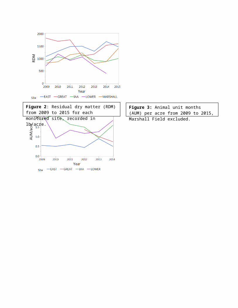
years (Fig 2). Animal unit months (AUM)/acre were lowest for the East Meadow. For all other
grazed sites AUM/acre fluctuated between 1 and 2.5 (Fig 3). Mean bare ground remained below
10% for most sites with the exception of Lower Hagar and IAA. Lower Hagar experienced a
spike in bare ground only in 2011. IAA bare ground fluctuated around 10% beginning in 2011
(Fig 4). Native grass cover remained below 10% for most sites; Lower Hagar experienced a rise
in 2012 until monitoring was discontinued in 2014. Marshall Field had the highest native grass
cover remaining above 20% (Fig 5). Native forb cover has remained below 7%; most sites
fluctuate inter-annually but no increasing trends are evident. There have been no native forbs
recorded in Lower Hagar during this monitoring study (Fig 6).
Mean vegetative cover peaked during 2010 for most sites and has decreased thereafter.
The Great Meadow experienced the largest fluctuation in vegetative cover between 2010 and
2012 (Fig 7). Mean canopy height fluctuated between 20 and 50 cm for monitored plots (Fig 8).
Litter depth has remained below 10cm for most sites; Marshall Field initially experienced the
highest litter depth but this trend has declined in recent years (Fig 9).

Figure 2: Residual dry matter (RDM) from 2009 to 2015 for each monitored site, recorded in lb/acre.
Figure 3: Animal unit months (AUM) per acre from 2009 to 2015, Marshall Field excluded.
Figure 1: The annual rainfall year (Oct 1st -Sept 31st) from 2008-2015. Data from the De Laveaga weather station, CA. Recorded in inches, summed at the end of each rainfall year.
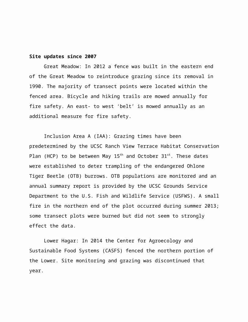
Figure 4: Mean percent bare ground from 2009 to 2015 for each monitored site
Figure 5: Mean percent native grass from 2009 to 2015 for each monitored site
Figure 6: Mean percent native forbs from 2009 to 2015 for each monitored site
Figure 7: Mean percent vegetative cover from 2009 to 2015 for each monitored site

The strength of correlation between precipitation, AUM/acre, and monitored variables
varied heavily across sites and variables measured. In the East Meadow there were no significant
correlations with any monitored variable and no correlations were observed for RDM, percent
native forb, and canopy height for any site (Table 1&2).
Table 1: Correlation statistics for precipitation from 2009-2015. Significant p-values (p < 0.05) are highlighted.
Precip RDM Litter %Bare Ground
%Grass %Cover %Forb Canopy
r2 p r2 p r2 p r2 p r2 p r2 p r2 pEM 0.11 0.4645 0 0.9961 0.11 0.4583 0.02 0.7817 0.51 0.0697 0.31 0.7364 0 0.6173
GM 0.16 0.3668 0.61 0.0387 0.12 0.4447 0.64 0.0314 0.08 0.5355 0.19 0.3252 0.16 0.3713
IAA 0.07 0.5765 0.68 0.0218 0.72 0.0161 0.21 0.2979 0.63 0.0323 0.11 0.4523 0.26 0.2374
LH 0.51 0.1134 0.15 0.4479 0.40 0.1772 0.88 0.0055 0.38 0.1895 N/A N/A 0 0.8119
MF 0 0.9571 0.04 0.6789 0.63 0.0324 0.63 0.0609 0.76 0.0102 0.60 0.0695 0.24 0.2623
Figure 9: Mean litter depth (cm) from 2009 to 2015 for each monitored site
Figure 8: Mean canopy height (cm) from 2009 to 2015 for each monitored site

Table 2: Correlation statistics for Animal Unit Months (AUM)/acre from 2009-2015. Significant p-value (p < 0.05) are highlighted. Marshall Field excluded due to no grazing.
AUM/acre X
RDM Litter %Bare Ground
%Grass %Cover %Forb Canopy
r2 p r2 p r2 p r2 p r2 p r2 p r2 pEM 0.09 0.5741 0.07 0.6249 0.21 0.3575 0.35 0.2173 0.11 0.5181 0.99 0.0002 0.68 0.0444
GM 0.04 0.7018 0.77 0.3218 0.85 0.2545 0.70 0.3664 0.99 0.0325 0.56 0.4619 0.35 0.5986
IAA 0.04 0.7018 0.25 0.3078 0.23 0.3413 0.01 0.8405 0.33 0.2319 0 0.9214 0.25 0.3164
LH 0.52 0.1022 0.09 0.5653 0 0.9798 0.04 0.7211 0.14 0.4643 N/A N/A 0.03 0.7421
Discussion
Most monitored sites, with the exception of the East and Great Meadow, had a RDM
below 1200 lb/acre. The litter depth remained below 8cm and percent bare ground remained
below 15% for all sites. This suggests that the fire safety objective has been met for most sites.
The East Meadow experienced the least AUM/acre as well as predetermined grazing schedules
outlined in the UCSC Ranch View Terrace HCP. This reduced grazing density and duration may
have affected the monitored RDM. The Great Meadow reintroduced grazing in 2012 and
corresponded with a decline in RDM, although subsequent years a rise in RDM was observed.
The East and Great Meadow both have RDM higher than the recommended 1200 lb/acre, but
achieved recommended litter depth and bare ground. Litter depth provides an indicator of
potential wildlife threat and bare ground provides potential fuel break during a wildfire (Self
2004). These data suggest that for the East and Great Meadow marginal fire safety has been
achieved.
Native forbs have remained below 8% with no trends suggesting an increase in grazed
sites. Native grass has remained below 10% for most sites, Lower Hagar increased above this
before monitoring was discontinued in 2014. The highest percentage of native grass monitored
was in Marshall Field, an un-grazed site. The lack of increasing native species abundance in
grazed sites suggests that the native species objective has not been met. It is difficult to observe
native grass responses to recent grazing, as in the Great Meadow, due to their slow growth (Lynn
2007) and low initial cover. Other confounding factors like land management and un-
documented land use can radically affect the native adult species and seed bank. For example,
Lower Hagar observed no native forbs suggesting a lack of a viable seed bank. Marshall Field is
noted to have a history of controlled burns, with most recent occurring in 1999, and little to no
documented history of grazing or tilling (Self 2004). Rare species like Plagiobiothrys reticulates
var. rossianorum (San Francisco popcorn flower) and the Ohlone Tiger Beetle (Cicindela
ohlone) have been found in Marshall Field, although they have faced habitat disruption from
mountain bikers and hikers.
Other observed trends may be due to confounding factors beyond the scope of this
monitoring project. Initially I believed precipitation would have been correlated with RDM and

canopy height although no statically significant correlations were observed. The rancher Peter
Arvelas had noted that in 2014, a severe drought year, Avena spp had been observed to be over
1m in height in many grasslands of Northern California (Bill Reid 2016 pers. Comm). Canopy
height is very sensitive to phenological timing, most recent grazing, and provides little data with
respect to management objectives (Lynn 2007). Other confounding factors may have affected
CCP growth and/or the data collection process that could not be identified in this monitoring
update.
Recommendations
From these result I offer the following management recommendations:
1) Earlier and more intense grazing in non-HCP grassland to reduce invasive species cover,
decrease RDM, and potentially increase native species abundance.
2) Increase fenced grazing area in the Great Meadow to reduce potential fire hazards and further
monitor CCP responses to grazing treatments.
3) The UCSC Grounds Services should pursue a prescribed burn permit for Marshall Field in
lieu of grazing management.
4) Create fenced areas in the OTB reserve of IAA and areas of Marshall Field to prevent habitat
disruption from hikers and mountain bikers.
5) Discontinue collecting canopy height in spring monitoring. Begin monitoring litter depth
during fall RDM data collection.
6) Collect and propagate native coastal prairie seed for habitat restoration to better meet SSGMP
objective of increasing native species abundance
Acknowledgments
Dr. Karen Holl, Dr. Grey Hayes, Scott Loosley, Jamie Self, and Lucy Lynn were vital in
the creation and implementation of the SSGMP. Dave Roe, Bill Reid, and countless SSP interns

maintained and collected the essential data for this monitoring update. Dr. Karen Holl also
provided crucial advisement in the statistical analysis and editing of this document.
Work Cited

Bartolome, J.W., J.S. Fehmi, R.D. Jackson, B. Allen-Diaz. 2004. Response of a native
perennial grass stand to disturbance in California’s coast range grassland. Restoration Ecology.
12(2):279-289.
Bartolome, J.W., W.E. Frost, N.K. McDougald, and J.M. Connor. 2006. California
guidelines for Residual Dry Matter (RDM) management on coastal and foothill annual
rangelands. Univ. Calif. Div. Agric. Nat. Res. Rangeland Management Series Pub. 8092
(revised). 8p.
CNPS, Rare Plant Program. 2016. Inventory of Rare and Endangered Plants (online
edition, v8-02). California Native Plant Society, Sacramento, CA. Website
http://www.rareplants.cnps.org [accessed 18 February 2016].
D’Antonio, Carla, et al. "Ecology and restoration of California grasslands with special
emphasis on the influence of fire and grazing on native grassland species." Report to the Packard
Foundation (2002).
Dyer, A. R. 2002. Burning and grazing management in a California grassland: Effect on
bunchgrass seed viability. Restoration Ecology. 10(1): 107-111
Dyer, A. R. 2003. Burning and grazing management in California grassland: growth,
mortality, and recruitment of Nassella pulchra. Restoration Ecology. 11(3): 291-296.
Hayes, G.F. and K. Holl. 2003. Cattle grazing impacts on annual forbs and vegetation
composition of mesic grasslands in California. Conservation Biology. 17(6): 1694-1702.
.
Heady, Harold F., et al. "Coastal prairie and northern coastal scrub." Terrestrial
vegetation of California. California Native Plant Society, Sacramento 1002 (1988): 733-760.
Loik, Michael E., et al. "A multi-scale perspective of water pulses in dryland ecosystems:
climatology and ecohydrology of the western USA." Oecologia 141.2 (2004): 269-281.

Lynn, L. 2007. UCSC Site stewardship grassland monitoring program progress report.
Senior internship project, University of California, Santa Cruz.
Marty, J. T. 2005. Responses of a remnant California native bunchgrass population to
grazing, burning, and climatic variation. Conservation Biology. 19(5):1626-1632.
Reid, Bill. 2016. Personal communication with long-time UCSC SSP coordinator, Bill
Reid.
Self, J. 2004. Development of a UCSC Grassland Monitoring Program. Department of
Environmental Studies. University of California Santa Cruz.
Stromberg, M.R., and J.R. Griffin. 1996. Long-term patterns in coastal California
grasslands in relation to cultivation, gophers, and grazing. Ecological Applications. 6(4): 1189-
1211.
Stromberg, Mark R., Paul Kephart, and Vern Yadon. 2002 “Composition, Invasibility,
and Diversity in Coastal California Grasslands”. Madroño 48.4 (2001): 236–252. Web.