village of downers grove plan commission minutes plan commission meeting nov. 6, 2017 1 village of...
TRANSCRIPT

VILLAGE OF DOWNERS GROVE
PLAN COMMISSION
VILLAGE HALL COUNCIL CHAMBERS
801 BURLINGTON AVENUE
December 4, 2017
7:00 p.m.
AGENDA
1. Call to Order
a. Pledge of Allegiance
2. Roll Call
3. Approval of Minutes – November 6, 2017
4. Public Hearings
a. 17-PLC-0031: A petition seeking approval of a Special Use and setback
Variation to allow a school addition. The property is zoned INP-1,
Neighborhood-Scale Institutional and Public. The property is located at the
northeast corner of Main Street and Franklin Avenue, commonly known as
4832 Highland Avenue, Downers Grove, IL (PIN 09-08-110-017). Diocese
of Joliet, Petitioner; Roman Catholic Diocese of Joliet Trust, Owner.
5. Adjournment
THIS TENTATIVE REGULAR AGENDA MAY BE SUBJECT TO CHANGE

DRAFT MINUTES
Plan Commission Meeting Nov. 6, 2017
1
VILLAGE OF DOWNERS GROVE PLAN COMMISSION MEETING
MINUTES FOR NOVEMBER 6, 2017
Chairman Rickard called the November 6, 2017 meeting of the Plan Commission to order at 7:03 p.m. and led in reciting the Pledge of Allegiance. ROLL CALL: PRESENT: Chairman Rickard, Mr. Boyle, Ms. Gassen, Mr. Kulovany, Mr. Maurer, ABSENT: Ms. Johnson, Mr. Quirk, Ms. Rollins, Ex. Officio members Miller, Livorsi & Menninga STAFF: Village Sr. Planner Rebecca Leitschuh Village Planner, Swati Pandey Village Planner, Scott Williams VISITORS: Jim Wilkinson, 1125 Black Oak; Janice Sommer, 4824 Florence; William and Julie Tyree, 4409 Downers Dr.; Victor Hernandez, William Shelby and Jim Sideris, Interstate Construction, 150 S. Wacker Drive, Ste. 2400, Chicago; Mark Thoman, Downers Grove Township, 4340 Prince. APPROVAL OF MINUTES: October 2, 2017 meeting Ms. Gassen moved, seconded by Mr. Boyle to approve the minutes for the October 2, 2017 meeting as presented. The Motion to approve the minutes as presented passed unanimously by voice vote. Chairman Rickard reviewed the procedures to be followed for the meeting, explaining that the Plan Commission is a recommending body for the petitions on the Agenda. Once the Public Hearing portion of the meeting is closed, the Plan Commission members will deliberate to recommend approval, recommend approval with conditions or recommend denial of the petition. That recommendation will be forwarded to the Village Council together with all supporting documentation on the petitions. The Village Council will make final decisions at a future date. He reviewed the subject matter of the three petitions on the Agenda, and then asked all individuals intending to speak during the public hearings to rise and be sworn in. Ch. Rickard noted that File 17-PLC-0014 is continued from the October 2, 2017 meeting.

DRAFT MINUTES
Plan Commission Meeting Nov. 6, 2017
2
Ch. Rickard then asked if there were any objections to moving the Township item first, since they anticipate it being a quick hearing. There were no objections from the Commissioners or Staff. PUBLIC HEARING FILE 17-PLC-0030: A petition seeking approval of a Zoning Map Amendment to rezone the property to INP-1, Neighborhood-Scale Institutional and Public. The property is zoned R-6 Residential Apartment/Condo 6 and B-2, General Retail Business. The property is located on the north side of Sherman Street, between Saratoga Avenue and Prince Street, commonly known as 4340 Prince Street, Downers Grove, Il (PINs 09-05-302-003, -004, -005, 006, and -010). Mark Thoman on behalf of Township of Downers Grove, Petitioner and Owner. Ms. Swati Pandey, Planner for the Village, stated the owner of the property is the Downers Grove Township, and the property is located north of Sherman Street, and northwest of Downers North High School. The property consists of multiple parcels. The parcels to the east are zoned commercial and are improved with a one-story office building and a surface parking lot. The parcels to the west are vacant and zoned multi-family. The owner’s intention is to bring all of these lots into a single zoning designation and to rezone the property to INP-1, which is intended for small, public, civic and institutional scale developments that are near residential neighborhoods. The Village’s Future Land Use Plan identifies the lot to the east as INP-1, with the lots to the west as commercial. The land is held under common ownership and the Staff believes the Township has no intention of developing this for other than institutional use. It makes sense to have this property aligned with the Comprehensive Plan as well as the Zoning Ordinance. Staff believes that the application meets the requirements established by the Village's Zoning Ordinance and Comprehensive Plan, as stated in Staff’s report dated November 6, 2017. Staff recommends that the Plan Commission make a positive recommendation regarding the Zoning Map amendment for this property. Mr. Mark Thoman said he was on the original Comprehensive Plan update and was a member of the Plan Commission and is familiar with the INP-1 and INP-2 designations. He thanked Community Development for their cooperation in getting this proposal before the Plan Commission and the Village Council. Ch. Rickard called for public comments, and there were none. He closed the pubic portion of the meeting. There were no comments from members of the Plan Commission. Mr. Kulovany moved with regard to File 17-PLC-0030 that the Plan Commission forward a positive recommendation to the Village Council to approve this request. Mr. Maurer seconded the Motion. AYES: Mr. Kulovany, Mr. Maurer, Ms. Gassen, Ch. Rickard NAYS: None The Motion passed unanimously.

DRAFT MINUTES
Plan Commission Meeting Nov. 6, 2017
3
•••••••••••••••••••••••••••••
FILE 17-PLC 0014 – (Continued from October 2, 2017): A petition seeking approval of a Special Use and Setback Variation to allow a drive-through restaurant facility, a Special Use for a gas station, a Final Plat of Subdivision, and an alley vacation. The property is zoned B-3, General Services and Highway Business. The property is located at the southeast corner at the intersection of Ogden Avenue and Belmont Road, commonly known as 2125 Ogden Avenue, Downers Grove, IL (PIN 08-01-405-042). C.M. Lavoie & Associates, Petitioner and Powermart Real Estate Downers Grove #3, LLC, Owner. Ms. Swati Pandey, Planner for the Village said the applicant proposes resubdividing the property into two new lots to construct a gas station/convenience store on one lot, and a restaurant/drive-thru on the other lot. The drive-thru facility is on the east side of the building. The property, located at the southeast corner of Ogden and Belmont, was formerly a gas station/car wash facility. The buildings on the property are currently vacant. The curb cuts on Ogden Avenue and Belmont Road have been reconfigured. Ms. Pandey showed a plat of survey for the property. A gas station and drive-through are both special uses, while the convenience store and restaurant are both permitted uses for the site. The zoning variation requested is associated with the setback for the drive-through lane for the restaurant, as well as a final plat of subdivision to subdivide the property into two lots, with the intention of keeping both of the uses on separate lots. There is an exception requested to allow a reduced width for Lot 1. The final request is for an alley vacation for a 20’ alley unimproved to the rear of the property. Ms. Pandey showed slides depicting current conditions of the property. The applicant is requesting that the 270’ long unimproved alleyway which is 20’ in width be vacated. The majority of the alley will remain unimproved with the exception of a 5’ strip which will encroach the north side of the alley in order to accommodate the full width of the drive-through lane. The applicant has proposed the configuration of the two lots as shown on the Plat of Subdivision Site Plan as submitted by the applicant. The intent is to keep the gas station canopy and the convenience store on their own lot to the west as it involves a number of underground and aboveground facilities for the use. This configuration does not allow Lot 1 to meet the required 100’ width at the property line, and the applicant is seeking an exception for that width. A blanket egress/ingress access easement will be provided for the entire site primarily for the purposes of parking and traffic circulation. Ms. Pandey showed the proposed site plan with curb cuts along Belmont and Ogden which have been reconfigured to one curb-cut for each side. The drive-through is behind the building following west to east going north along the side of the building. She showed the 5’ encroachment into the alleyway. Parking has been evaluated for the entire site for each use to allow cross access for the entire parking area. The trash enclosure has been provided at the southeast corner of the property and meets the minimum zoning and locational requirements. The Site Plan provides for pedestrian access both along Ogden Avenue and Belmont Road. There is a condition of approval
DRAFT MINUTES
Plan Commission Meeting Nov. 6, 2017
4
added to the Staff Report to improve the configuration for the pedestrian access to Ogden Avenue. The Landscape Plan for the property has been evaluated for the minimum overall site open space requirements as well as perimeter landscaping which includes street yard landscaping along Ogden and Belmont Road. The photometric plan meets the minimum foot-candle levels, in particular the southern property line, which abuts a residential area that will be at zero. She then showed the elevation drawings for all of the buildings proposed, describing the materials to be used in the construction of the buildings. She noted that with the restaurant facility, the tenant will have to come back to the Village to request outdoor seating for their facility. The property has been identified as a catalyst site along Ogden Avenue in the Comprehensive Plan and meets a number of goals set by the Comprehensive Plan including: 1) removing two curb cuts and access onto both Ogden Avenue and Belmont Road; 2) improving site connectivity by installing pedestrian access from Ogden Avenue and Belmont Road to the two buildings and maintaining vehicular cross-access through an easement; 3) consolidating multiple lots into two lots and increasing depth for a functional site plan; and 4) providing enhanced landscaping and screening in order to provide a buffer to the residential areas to the south and a more attractive image at a community gateway intersection. Both Lots 1 and 2 meet the Zoning Ordinance requirements including the overall site development, with the exception of the drive-thru setback on the east and the south sides. The east side is a commercial property with a requirement of 25’, while the south side abuts a residential property where the requirement is greater at 50’. Staff supports the requested setback variation since there are limited choices for the location of the drive-thru. It also helps separate the pedestrian and vehicular activities. The Plat of Subdivision is in compliance for the most part with the Subdivision Ordinance requirements with exception of the width for Lot 1, which is at 66.73 feet as opposed to the 100’ required. Staff supports the requested exception for the reduced lot width considering the improvements that will be made by this configuration, in addition to the requirement that the gas station appurtenances and paraphernalia be required on a separate lot. The Plat of Subdivision approval criteria for the exception from Sec. 20.301 has been met and will not negatively impact the value or reasonable use of the surrounding property. This property has been vacant for a long time and the improvements will enhance the value of the surrounding property. The trend of development in the area for surrounding uses show differing lot widths in the immediate area. Staff feels that the approval criteria for the Plat of Subdivision exceptions have been met. The Special Use Criteria for Sec. 12.050.H has also been met since both uses are authorized in the Zoning Ordinance. Zoning variation requirements for the drive-thru setback are met since the site has been vacant and is currently not yielding any return on the property. Allowing the development to move forward would yield a reasonable return. The variation will not
DRAFT MINUTES
Plan Commission Meeting Nov. 6, 2017
5
alter the character of the community or neighborhood considering that the Board has previously reviewed a number of similarly situated drive-thru facilities with reduced setbacks along this corridor. The hardship is the land-locked situation of this particular site. Staff believes the criteria for Sec. 12.090.G for granting a zoning variation have been met. The alley vacation Res. #2003-58, Item 1 has not been met. While recognizing that Staff is in support of the plan, Staff has also been informed of the multiple contacts that applicant has made with the abutting property owners and has been unsuccessful in retrieving a response. Staff has also been informed that a provision in the Resolution allows the State law to take precedence under such conditions. As for other items under the Resolution, the public interest is served by providing the blanket easement. Staff has made contact with the outside agencies and the standard response has been to request a blanket easement, which has been agreed to by the applicant. The easement will be maintained. An appraisal has been provided by the applicant as to the type of compensation to be provided for the property vacation, and that will be reviewed at the discretion of the Village Council. Ms. Pandey said that the proposed Special Uses, Variation, and Plat of Subdivision with an exception for the development at 2125 Ogden Avenue are consistent with the Comprehensive Plan, the Zoning Ordinance and surrounding zoning and land use classifications. Staff recommends approval of the requested Special Uses, Variation, Plat of Subdivision with an exception, and Alley Vacation as requested in case 17-PLC-0014, recognizing that the proposal does not meet the vacation policy, subject to the seven conditions stated on page 11 of Staff’s report dated November 6, 2017. Ch. Richard asked, since these are going to remain two individual lots rather than a PUD or one lot, if they fall under separate ownership at any time, the trash is still being collected on one lot. Because it is a tight configuration, it would be difficult to provide a separate trash enclosure on the western lot. He is unclear if access to the trash is going to be part of the blanket easement, or whether there should be a statement to the effect that the property on the west would use the trash enclosure on the east lot. Ms. Pandey said she was unsure whether that was spelled out in the language for the easement. Sr. Planner Rebecca Leitschuh replied that there is equal access to everyone on the property; however a condition could be included so that the trash enclosure will forever apply to both properties. Ch. Rickard then inquired about the sign-off requirements for the alley vacation. He said he thought the sign-off requirement is the Village's responsibility. As long as reasonable attempts have been made by the applicant with no reply from surrounding properties, he said he thinks it is a Village requirement. Ms. Leitschuh read the policy statement:
“The validity of any vacation otherwise carried out in accordance with applicable law shall not be invalidated, impaired or otherwise affected by noncompliance with any part of the procedure set forth herein.”

DRAFT MINUTES
Plan Commission Meeting Nov. 6, 2017
6
The vacation policy is a “procedure” and not an Ordinance. To guarantee the applicant due process they have to carry forth an application, and Council will have to look at this to determine which procedures to follow. Mr. Boyle asked if any attempt was made to speak with the abutting neighbors regarding the setback variance. Ms. Pandey replied that the special use application and the associated requests do not require a neighborhood meeting. To her knowledge the applicant sent some plans and letters associated with the variance out to neighbors within a certain radius. The responses would have gone back to the applicant. She said she received one letter from a neighbor who had questions about the plans, which the neighbor said were not legible. Neither that neighbor, nor any others, have contacted Staff directly. Mr. Boyle then suggested that there be some type of operating agreement for ingress/egress. Ms. Pandey replied that for the most part the parking spaces are separated and in the Zoning Ordinance compliance sections, there is a section calling for overall site development compliance. Those elements have been reviewed for overall compliance. That did start with the drive-thru access and the entire parking lot. Mr. Boyle then asked about the reduction of curb cuts and whether that minimizes the traffic flow and whether a traffic study was performed. Ms. Pandey said when the application was received it went through the Traffic Manager’s review, and he did not see a potential problem. Mr. Kulovany asked how long the site has been vacant, and Ms. Pandey said she thought it might be 3-5 years. Ms. Pandey said there were no inquiries for this property to her knowledge. Mr. Kulovany then inquired about the vacation and whether it will be brought up to grade. Ms. Pandey said it will remain unimproved with only the 5’ being improved. She added further that the easement does not allow the property owner to the south to use it in the future. Mr. Chris Lavoie of C.M. Lavoie & Associates, said that this site had many different criteria. He said he is representing Powermart Corporation. The site belonged to Exxon/Mobile many years before. Mr. Lavoie said they wanted to take the site to a different level and turn it into a corporate image type of site, while meeting all of the requirements. He noted that they came into the project when the design work had already been done; however, they identified several issues that were of concern so they went after an all-new design to address traffic issues, eliminate access points, etc. He was excited to take another catalyst site in Downers Grove and make it look good and meet all the requirements. He said he had many agencies to deal with, as well as the Comprehensive Plan, and thanked Staff for all of their input in bringing this project to fruition. The vacation of the easement required contact with individual property owners and certified mail was sent to every one of the owners with a follow-up letter to the property owner to the south. He researched the owner who refused to sign-off on the vacation. Mr. Lavoie delayed coming to the Plan Commission hoping to obtain that last signature to no avail. Mr. Lavoie said he believes he is presenting a great project to the Village, with a unique design. He explained the materials used, landscaping, and overall aesthetics of the

DRAFT MINUTES
Plan Commission Meeting Nov. 6, 2017
7
construction. The only cross-over is the trash enclosure on the one lot with two trash enclosures to accommodate each lot. Ms. Gassen asked if there is a tenant for the restaurant, and Mr. Lavoie said that the tenant they are looking at has been in business for a long time. Ms. Gassen then asked whether he attempted to get in touch with the condo owners, and Mr. Lavoie said that they have a signature from the Condo Association, as well as a signature of one of the condo owners. He noted they have a signature from the neighboring property. Ms. Leitschuh said that there is a signature from a member of the Condo Association, however, that signature represents a single owner. Mr. Lavoie said that there are four units that are vacant. Ms. Gassen said there appear to be challenges associated with the fact that this is two lots. She asked why this was not made into one lot. Mr. Lavoie said one lot offers challenges as well, such as if there was a restaurant tenant who wanted to purchase the site, it would offer another option for the future. Mr. Boyle asked if there is underground storage, and Mr. Lavoie said they have a concrete walled vault for stormwater detention. They are also utilizing the old storage tanks from the previous gas station. There was a grant issued by the State of Illinois for the underground tanks that are there. There will be a small retaining wall in the back of the south lot. Ch. Rickard called upon the public for comments. There were none, and Ch. Rickard closed the public portion of the meeting. Mr. Kulovany said he was most concerned about neighboring consent, but it appears that all efforts were made to contact the neighboring owners. It is a catalyst site for a reason and is a gateway to the Village. He would vote in favor of the recommendation. Mr. Boyle asked about the $5,000 appraisal fee for the alley, and whether it is something that other owners can also apply for later. Ms. Leitschuh replied that the appraised value was for the entire portion they have requested. The way it is being petitioned, it gives full right to the applicant. Mr. Kulovany asked if the Plan Commission has the right to force an easement to an adjacent property owner and it was determined that the Commission could not do so. Ms. Gassen clarified that if they cannot get the signatures required for the procedure, State law allows for them to proceed anyway. Mr. Kulovany moved that in Case 17-PLC-0014 Special Use, Variation and Final Plat of Subdivision and Alley vacation that the Plan Commission make a positive recommendation to the Village Council including conditions 1-7 as shown in Staff’s Recommendation in its report dated November 6, 2017 on page 11. Ms. Gassen seconded the Motion. AYES: Mr. Kulovany, Ms. Gassen, Mr. Boyle, Mr. Maurer, Ch. Rickard NAYS: None

DRAFT MINUTES
Plan Commission Meeting Nov. 6, 2017
8
The Motion passed unanimously 5:0.
••••••••••••••••••••••••••••••
FILE 17-PLC-0027: A petition seeking approval of a Final Plat of Subdivision to subdivide the existing property into three lots and two outlots. The property is zoned O-R-M, Office-Research-Manufacturing. The property is located at the intersection of Lacey Road and Finley Road, commonly known as 3600-3800 Lacey Road, Downers Grove, IL (PIN 06-31-300-009). Mark Houser on behalf of Bridge Industrial Acquisition, LLC, Petitioner and CV Land Holding, LLC, ONER. Mr. Scott Williams, Village Planner, stated that the subject site is located at the intersection of Lacey and Finley Roads, is vacant and unimproved. Some of the property is farmland with dense vegetation to the south where the wetlands are located. He noted that Lacey Road is a village road while Finley Road is a county road. He reviewed the surrounding zoning and land uses for the area. The applicant is proposing three Class A industrial office buildings. They intend to subdivide an existing lot into three new buildable lots and two outlots. He reviewed where passenger vehicle parking will be located as opposed to semi-trailer trucks. Using site plans he showed where the access points would be located, as well as the roadway alignment exhibit. The goal was to show proper taper distances for left-hand turn lanes, and reflecting the incorporation of the small portion of land owned by the Forest Preserve to increase the roadway width. The applicant submitted a conceptual landscape plan. It reflects a 35’ setback and associated buffer along Lacey and Finley Roads, as well as detention basins that will be very natural looking. With regard to the Village's Comprehensive Plan, the Plan states that large-scale buildings and office parks play an important role in the local economy, and the Village should continue to support office development along the tollway corridors. The Plan also states that negative impacts on residential areas should be mitigated; however, there are no adjacent residential uses nearby. The Future Land Use Map identifies the property up and down Lacey Road as Office/Corporate Campus. There are no exceptions being proposed, and Staff recommends approval subject to the conditions listed on pages 4 and 5 of Staff’s report dated November 6, 2017. Mr. Boyle asked how many other 55-acre sites are still undeveloped in Downers Grove and Mr. Williams said that there were not many. This was the only one he knew of. As to the outlots on the south side, Mr. Williams said they would have to remain as is. Ms. Leitschuh said that the wetland area has to meet State and Federal laws, and those wetland areas are pretty much set in stone. Mr. Kulovany asked about the detention area and whether the overflow would go into the wetland area or the Downers Grove stormwater system. Mr. Williams said he thinks

DRAFT MINUTES
Plan Commission Meeting Nov. 6, 2017
9
they are controlling the discharge rates into the wetland areas but would have the petitioner respond to that. Mr. Steve Groetsema, partner of Bridge Development Partners, said they are the petitioner on this request and are the contract purchaser of the site He gave a background of Bridge Development Partners and what they anticipate doing on the subject site. They have been in business since 2000 and are headquartered in Itasca, IL. They have several other sites throughout the United States. They have received awards from various sources including Crain’s Chicago Business, and have developed over 20 million square feet, the majority of which is in Chicago. He reviewed other projects in the Chicagoland area over the last twelve months. They are the most active developer in the country from an industrial perspective. Chicago is the second largest industrial market in the country. Bridge primarily focuses in five major submarkets in the Chicago general area. Their buildings tend to appeal to a wide array of corporate users. He showed slides of four projects, which relate to the subject site including Woodridge, and the Amazon site in Waukegan. The subject project is being referred to as Bridgepointe Downers Grove. There are very few sites of this nature available that meet at two major highway intersections. They see it as a corporate headquarters type of consolidation. Occupancy costs will exclude distribution-type uses. Users for this site will have a significant labor need and will want to be centrally located. Those needs cannot be met in a more green-field location. Downers Grove is a wonderful location from an industrial perspective as well as light-assembly manufacturing perspective. In response to Mr. Boyle, Mr. Groetsema said they will be designing buildings that cater to users as small as 20,000 square feet and up to 80,000 square feet. When they design a building, it is a basic speculative build with a warm dark shell, four walls, roof and heaters inside without any office build out or lighting. They build to suit. He gave an O’Hare development as an example for how they determine what parking requirements would be. The industry standard for this type of building is one car per 1,000 square feet for each of the three buildings. They try not to mix cars and trucks. They will show truck-turning radii mostly for emergency vehicles. Based on the parking they are showing, they anticipate an average tenant about 65,000 square feet with about 7500 square feet of office. He thinks the office percentage of the subject site will be higher. They are already talking with two tenants interested in this development. Ch. Rickard clarified that the request is to create the lots, and Ms. Leitschuh said all the supplemental information is to help the Commission make an informed decision. It is only for the division of the land. Mr. Kulovany asked if the detention area would exit into the wetlands or the Village's stormwater system. Mr. Brett Duffy of Spaceco at 9575 W. Higgins Road in Rosemont said that the detention basin will drain south towards the wetland and floodplain at Lacey Creek. It will be an independent detention basin. The plantings will include native plantings to filter the water before it leaves the site.
DRAFT MINUTES
Plan Commission Meeting Nov. 6, 2017
10
There being no further questions for the petitioner, Ch. Rickard called upon the public for comments. 1. Bill Findlay of 987 Crescent Blvd., Glen Ellyn, asked who he should ask questions of regarding the traffic study. He wanted to talk to someone offline about the assumptions, nomenclature, etc. Ms. Leitschuh said that he can place his questions on the record, or contact Will Lorton, the Village's Traffic Engineer. Mr. Finley said that on page 4 it states that notice was provided to owners within 250’ of the subject property. Mr. Williams said it was sent to owners of record within that 250’ and he has had replies from Morton Arboretum, as well as other locations. Mr. Finlay said his family has owned the nine acres bordering this property to the south. They have been owners since 1946 and have been stable, respectful and considerate owners for over 50 years. He has listed his site for sale hoping to attract a developer. When they have taken their prospects to the Downers Grove Economic Development Corporation they have been told that under no circumstances would any industrial component be acceptable. He was surprised to see this public notice brought to his attention of a project described as three industrial buildings endorsed by Downers Grove. The largest of the buildings will be closest to his property. In discussing this proposal with his team members, they think their property value will be harmed. With industrial coming in on his north border it will limit his potential. He wants to discuss with Downers Grove a way to apply a consistent requirement or standard for construction on Finley Road, and not two different standards. Ch. Rickard said what is being proposed now is only creating a lot. He doesn’t think that is a question at this time. Ms. Leitschuh said that the EDC is a separate entity from the Village. The property is an unincorporated parcel as it is not annexed into the Village at this time. She can’t speak for the EDC. She said he was welcome to meet with Staff or the EDC. There being no further comments, Ch. Rickard closed the public portion of the meeting. Ms. Gassen moved that in File 17-PLC-0027 the Plan Commission forward a positive recommendation to the Village Council to approve the Final Plat of Subdivision with the seven conditions specified by Staff on page 5 of its report dated November 6, 2017. Mr. Maurer seconded the Motion. AYES: Ms. Gassen, Mr. Maurer, Mr. Boyle, Mr. Kulovany, Ch. Rickard NAYS: None The Motion passed unanimously 5:0.
••••••••••••••••••••••••••••
Ms. Leitschuh said that the State law they referenced earlier is Ch. 65, 5-11-91-1. Mr. Kulovany moved to adjourn the meeting, seconded by Mr. Boyle The Motion carried unanimously by voice vote. Chairman Rickard adjourned the meeting at 9:04 PM.

DRAFT MINUTES
Plan Commission Meeting Nov. 6, 2017
11
Respectfully submitted, Tonie Harrington, Recording Secretary (transcribed from recording)

VILLAGE OF DOWNERS GROVE REPORT FOR THE PLAN COMMISSION
DECEMBER 4, 2017 AGENDA
SUBJECT: TYPE: SUBMITTED BY:
17-PLC-0031 4832 Highland Avenue
Special Use with Variation
Scott Williams, AICP Planner
REQUEST The petitioner is requesting approval for a Special Use with a setback variation to allow a school addition to match the existing Franklin Street setback.
NOTICE The application has been filed in conformance with applicable procedural and public notice requirements. GENERAL INFORMATION
OWNER: Roman Catholic Diocese of Joliet Trust 425 Summit Street Joliet, IL 60435
APPLICANT: Christopher Nye
Diocese of Joliet 16555 Weber Road Crest Hill, IL 60403
PROPERTY INFORMATION
EXISTING ZONING: INP-1, Neighborhood-Scale Institutional and Public District EXISTING LAND USE: Institutional PROPERTY SIZE: 106,286 square feet (2.44 acres) PINS: 09-08-110-017
SURROUNDING ZONING AND LAND USES
ZONING FUTURE LAND USE NORTH: R-4, Residential Detached House 4 Single Family Detached SOUTH: DB, Downtown Business and R-5, Downtown/Mixed-Use & Single Residential Attached House 5 Family Residential EAST: R-4, Residential Detached House 4 Single Family Detached WEST: INP-1, Neighborhood-Scale and Public District Institutional/Public
ANALYSIS SUBMITTALS

17-PLC-0031, 4832 Highland Avenue Page 2 December 4, 2017
This report is based on the following documents, which are on file with the Department of Community Development:
1. Application/Petition for Public Hearing 2. Plat of Survey 3. Project Summary 4. Proposed Site Plan 5. Building Coverage Exhibit 6. Engineering Plans 7. Architectural Plans
PROJECT DESCRIPTION The subject property, 4832 Highland Avenue, is located at the northwest corner of Highland Avenue and Franklin Street. The property contains an existing church, school, administration offices and parking areas. The petitioner is requesting approval to construct an approximately 3,900-square-foot school addition. This addition would be setback of 8.97 feet from the Franklin Street property line and extend an existing, lawful nonconforming wall. The petitioner is proposing to expand the school’s footprint into the northeast corner of Main Street and Franklin Street, an area that is currently asphalt and concrete. This would extend the Franklin Street façade 44 feet to the west along the existing 8.97-foot street setback. The proposal also includes a brick paver patio, planters, landscaping and retaining walls. These features will be built around an outdoor classroom area near the new entryway. The building will have the following architectural features: a canopy with a green roof over the entryway, shading/light shelves, seating bay, windows and parapet walls. The addition will accommodate modernized classroom space, enhanced accessibility, add administrative space and allow for the installation of a new fire suppression system. The applicant is not proposing this addition to increase enrollment. The adjacent parking lot area will be reconfigured to accommodate the addition and a relocated trash enclosure in a code compliant location. This will result in a reduction of 8 parking spaces leaving a total of 132 spaces. However, there is still an overall increase of 18 parking spaces compared to the 114 parking spaces available before the recent west-side parking lot expansion project (subject of 17-PLC-0010). The two, one-way Main Street access points will remain the same and will not be impacted by the parking lot reconfiguration. Although the parking lot is used on a daily basis, the most intense use occurs during special events and religious services when off-duty police direct traffic. COMPLIANCE WITH COMPREHENSIVE PLAN The existing church, private school, and accessory parking are institutional uses. A goal of the comprehensive plan is for the Village to support the continued operation and improvement of schools while mitigating negative impacts on the adjacent residential area. There is no anticipated increase in enrollment associated with this proposal. The recent parking lot expansion on the west side of Main Street provides sufficient parking for the campus. Staff finds that continued use of this property as a religious assembly and private school use is consistent with the Comprehensive Plan. COMPLIANCE WITH ZONING ORDINANCE The subject property is zoned INP-1. The Special Use is required due to the proposed increase in building coverage and reduction in parking spaces. Per Section 4.020.B.3 of the Zoning Ordinance, buildings and structures in the INP-1 district shall follow the setbacks of the most restrictive abutting
17-PLC-0031, 4832 Highland Avenue Page 3 December 4, 2017
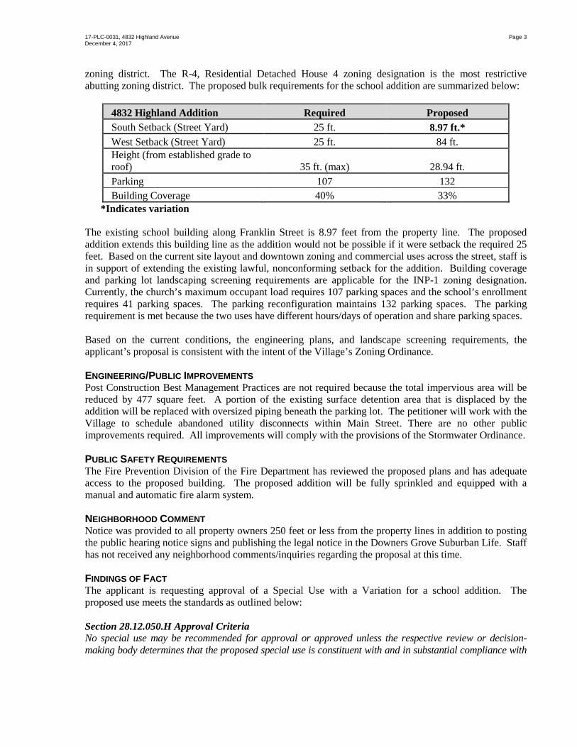
zoning district. The R-4, Residential Detached House 4 zoning designation is the most restrictive abutting zoning district. The proposed bulk requirements for the school addition are summarized below:
4832 Highland Addition Required Proposed South Setback (Street Yard) 25 ft. 8.97 ft.* West Setback (Street Yard) 25 ft. 84 ft. Height (from established grade to roof) 35 ft. (max) 28.94 ft. Parking 107 132 Building Coverage 40% 33%
*Indicates variation The existing school building along Franklin Street is 8.97 feet from the property line. The proposed addition extends this building line as the addition would not be possible if it were setback the required 25 feet. Based on the current site layout and downtown zoning and commercial uses across the street, staff is in support of extending the existing lawful, nonconforming setback for the addition. Building coverage and parking lot landscaping screening requirements are applicable for the INP-1 zoning designation. Currently, the church’s maximum occupant load requires 107 parking spaces and the school’s enrollment requires 41 parking spaces. The parking reconfiguration maintains 132 parking spaces. The parking requirement is met because the two uses have different hours/days of operation and share parking spaces. Based on the current conditions, the engineering plans, and landscape screening requirements, the applicant’s proposal is consistent with the intent of the Village’s Zoning Ordinance. ENGINEERING/PUBLIC IMPROVEMENTS Post Construction Best Management Practices are not required because the total impervious area will be reduced by 477 square feet. A portion of the existing surface detention area that is displaced by the addition will be replaced with oversized piping beneath the parking lot. The petitioner will work with the Village to schedule abandoned utility disconnects within Main Street. There are no other public improvements required. All improvements will comply with the provisions of the Stormwater Ordinance. PUBLIC SAFETY REQUIREMENTS The Fire Prevention Division of the Fire Department has reviewed the proposed plans and has adequate access to the proposed building. The proposed addition will be fully sprinkled and equipped with a manual and automatic fire alarm system. NEIGHBORHOOD COMMENT Notice was provided to all property owners 250 feet or less from the property lines in addition to posting the public hearing notice signs and publishing the legal notice in the Downers Grove Suburban Life. Staff has not received any neighborhood comments/inquiries regarding the proposal at this time. FINDINGS OF FACT The applicant is requesting approval of a Special Use with a Variation for a school addition. The proposed use meets the standards as outlined below: Section 28.12.050.H Approval Criteria No special use may be recommended for approval or approved unless the respective review or decision-making body determines that the proposed special use is constituent with and in substantial compliance with

17-PLC-0031, 4832 Highland Avenue Page 4 December 4, 2017
all Village Council policies and plans and that the applicant has presented evidence to support each of the following conclusions: (1) That the proposed use is expressly authorized as a Special Use in the district in which it is to be
located. Under Section 5.010 of the Zoning Ordinance, the expansion of a private, religious school and
reconfiguration of ancillary parking is listed as an allowable Special Use in the INP-1 zoning district. This standard has been met.
(2) That the proposed use at the proposed location is necessary or desirable to provide a service or a
facility that is in the interest of public convenience and will contribute to the general welfare of the neighborhood or community.
The petitioner is proposing modernized and code compliant school facilities that allow for more effective use of the site and building. There is no corresponding increase in student enrollment that is providing the impetus for this request. Furthermore, the petitioner’s proposed use will meet various Comprehensive Plan goals. This standard has been met.
(3) That the proposed use will not, in the particular case, be detrimental to the health, safety or general
welfare of persons residing or working in the vicinity or be injurious to property values or improvements in the vicinity. The proposed use will not be detrimental to the health, safety or general welfare of persons residing in or working in the vicinity and will not be injurious to property values or improvements in the vicinity. The petitioner will be maintaining the same use and intensity level. The rooftop mechanical units and the trash enclosure will be screened. A buffer of landscaping is shown around the entryway/outdoor classroom area and reconfigured section of the parking lot. The addition is across the street from three other non-residential uses, and is not adjacent to single family zoning. This standard has been met.
Section 28.12.090.G Approval Criteria Variations require evaluation per Section 28.12.090 of the Municipal Code, Standards and Review Criteria: “No variation may be approved unless the variation to be approved is consistent with the spirit and intent of this zoning ordinance and that strict compliance with the subject provisions would result in practical difficulties or particular hardships for the subject property owner. The consideration of whether a variation request has met the standards of practical difficulties or particular hardships must include all of the following findings from the evidence presented:” (1) The subject property cannot yield a reasonable return if required to comply with the regulations that
apply to it. The property is currently yielding a reasonable return, but requires modernized educational facilities and has to meet parking requirements. The proposed addition will address accessibility issues within the existing school building. This standard has been met.
(2) The plight of the owner is due to unique circumstances.
A private school, religious institutional and ancillary parking uses are located on the subject property. The adjacent R-4 single family bulk requirements apply. The applicant is requesting to match the existing Franklin Street setback, across the street from non-residential zoning and an established commercial building. The school addition would not accomplish its desired outcomes if it was required to meet the required setback. This standard has been met.
(3) The variation, if granted, will not alter the essential character of the locality.

17-PLC-0031, 4832 Highland Avenue Page 5 December 4, 2017
The proposed variation will not alter the essential character of the locality. The uses will remain the same and are not intensifying. The requested variation more closely matches the existing and allowable setbacks for the neighboring three corners at the intersection of Franklin Street and Main Street. This standard has been met.
(4) That the particular physical surroundings, shape, or topographical conditions of the subject property would result in a particular hardship upon the owner, as distinguished from a mere inconvenience, if the strict letter of the regulations were carried out. The property presents a physical hardship to meet the setback, parking, and stormwater requirements. If the school addition was modified to meet both street setbacks, then it would extend farther west into the parking area towards Main Street. This drastic site and architectural redesign would not match visually with the existing walls and further reduce the number of proposed parking spaces. The applicant is also moving the trash enclosure to a code compliant location to accommodate the addition. The variation request meets the spirit and intent of the Zoning Ordinance. This standard has been met.
(5) That the conditions leading to the need of the requested variation are not applicable, generally, to other properties within the same zoning classification. The conditions leading to the requested variation are specific to this property. Based on the INP-1 zoning designation, the variations are from the adjacent R-4, Residential Detached House 4 primary structure setbacks. To the south, much of the property is across the street from D-B, Downtown Business zoning. As such, the variation request is only applicable to this property. This standard has been met.
(6) That the alleged difficulty or hardship was not created by the current property owner. There is no particular difficulty or physical hardship associated with the property that has resulted from the actions of the owner. The petitioner is requesting to match an existing street setback and meet the goals of the Village’s Comprehensive Plan. This standard had been met.
(7) That the proposed variation will not impair an adequate supply of air to adjacent property, or substantially increase the danger of fire, or otherwise endanger the public safety, or substantially diminish or impair property values within the neighborhood. The approval of the proposed variation will not diminish or impair the property values of similar properties within the neighborhood. Adequate landscaping, screening and buffering will be provided so as to not endanger the public health, safety or welfare. The addition will meet all public safety requirements. Granting of the requested variation will not negatively impact the desirability of adjacent properties. This standard has been met.
(8) That the proposed variation will not alter the essential character of the area. The granting of a variation will not alter the essential character of the area as it reflects existing uses and street setbacks. This standard has been met.
(9) That the granting of the variation will not confer on the subject property owner any special privilege that is not available to other properties or structures in the same district. If this request is granted it will not confer a special privilege to the subject property owner as there are physical hardships and unique circumstances associated with this property that are not common with the properties found in the same zoning district. This standard has been met.
RECOMMENDATIONS
The proposal is consistent and compatible with the Comprehensive Plan and surrounding zoning and land use classifications. Based on the findings listed above, staff recommends the Plan Commission make a

17-PLC-0031, 4832 Highland Avenue Page 6 December 4, 2017
positive recommendation to the Village Council regarding 17-PLC-0031 subject to the following conditions:
1. The Special Use with a Variation shall substantially conform to the staff report dated December 4, 2017, the drawings prepared by Serena Sturm Architects dated October 20, 2017, landscape drawings prepared by Green Grass Landscape Architecture & Construction dated October 20, 2017, and engineering drawings prepared by V3 Companies dated October 20, 2017, except as such plans may be modified to conform to Village Codes and Ordinances.
2. The applicant shall coordinate the closure of Main Street for disconnects and utility connections with the Village.
Staff Report Approved By:
___________________________ Stanley J. Popovich, AICP Director of Community Development
SP:sw -att P:\P&CD\PROJECTS\PLAN COMMISSION\2017 PC Petition Files\17-PLC-0031- St. Joseph- Special Use and Variation\17-PLC-0031 Staff Report.docx

V3 COMPANIES 7325 JANES AVENUE, WOODRIDGE, IL 60517 PH: 630.724.9200 FX: 630.724.9202 V3CO.COM
VISIO, VERTERE, VIRTUTE … THE VISION TO TRANSFORM WITH EXCELLENCE
Concept Engineering Site Design Narrative
St. Joseph’s School Addition Downers Grove, Illinois
Date: October 27th, 2017
The St. Joseph Catholic Community intends to improve the east lot of its campus located at the north east corner of Franklin and Main in Downers Grove, Illinois. It is our understanding that the improvements include expanding the existing southern building due west, providing detention in oversized pipes along the western property line, connecting to the sanitary sewer in Main Street, and constructing a new trash enclosure. The existing pavement will be removed under the proposed building footprint and in utility construction areas. A portion of the retaining wall along Franklin Street will also be removed. The Preliminary Layout, Grading, and Utility Plan dated October 20th, 2017 has been prepared by V3. This plan shows the proposed drainage and detention design, which is detailed below. The site has been designed to comply with the DuPage County Stormwater Management Ordinance and the Downers Grove Municipal Code Stormwater and Flood Plain Ordinance, when more restrictive. Stormwater detention is required when a site’s net new impervious area is increased by 25,000 SF. As can be seen in the Disturbance Exhibit, the impervious area will be condensed by 477 SF. However, 0.022 AC-Ft of existing detention that was provided on the surface of the south portion of the parking lot is being eliminated by the building expansion. With the proposed design, the 0.022 Ac-Ft will be provided below ground in oversized storm sewers. See the Existing Detention Exhibit and East Lot Storage Table for more information. Post construction best management practices (PCBMP’s) are not required because the impervious area will be reduced by 477 SF. The site will be designed to comply with applicable ordinances and engineering principles.

!
!
!
! !
!
!
!
!
!
!
!
!
!
!
!
!!
!
!
!
!
!
!
!
!
!
!
!
!
!
!
!MA
IN ST
HIGH
LAND
AVE
PRAIRIE AVE
FRANKLIN ST
FRANKLIN ST
4800
4845
4816
4905
4804
4803
4904
4800
4901
4812
4910
4819
4810
4827
4802
4820 4815
48074808
4816
4831
4900
4811
4823
4804
4905
4832
4900
48054801
4824
4832
1020
4832 Highland-Location Map 0 30 60
Feet
MAIN
ST
PRAIRIE AVE
BRYA
N PL
FORE
ST AV
E
HIGH
LAND
AVE
FRANKLIN ST̂_
_̂
FCC
FCC
202SCC
726.06
725.93
725.72
725.81
728.86
FCC
203SCC
731.75732.01
731.50731.78
731.62
731.35
731.37731.66732.00731.72
731.07
730.20
731.66731.91
731.9
731.56731.76
731.80
731.7
731.67
731.37731.02
731.45731.72
731.24
731.51731.86
731.16731.16
730.68
730.88
730.79
730.77730.92
730.97
730.76
730.60
730.77730.72 730.90
730.68
729.83
731.39731.72
731.39 731.15
731.20
731.33
731.04730.83
730.55
730.49
730.49730.59 730.71
728.6
3
728.6
2
728.7
0
728.51
728.55
728.60
728.34728.45
728.23
730.91
728.23
730.44
730.99
730.43730.91
732.84 731.73
12"10"10"12"
5"
731.99732.41732.03 731.56
730.66
732.08732.42
732.4
732.21732.57
732.24732.24
732.66732.38
732.61
732.64
732.77
732.9
1
733.2
6733.2
5
732.77732.84
732.55732.87733.0
731.59
731.42
732.21732.47
730.80
732.48
732.22
731.63731.39
731.82
732.71733.04
733.1
734.08
734.08
734.04
733.1
732.97
732.68731.70
731.46731.99732.29
731.97732.26
732.33
732.00732.30
732.48
731.89
732.14732.42
732.01
732.03731.90731.68732.04
732.16
732.18
732.31
732.26732.06
732.29732.57732.65
732.78
732.68
732.36
732.33732.66
732.84732.82
732.9
15"732.4
732.6
732.42
732.71
732.81732.79
732.84
732.90732.99
732.82
732.40732.31
732.38
732.39732.40
732.90
733.00732.99
732.87
732.79732.76
733.00
732.95
732.69
732.35
732.77
732.79
732.45732.51
732.48732.76
732.83
732.84
732.78
732.75
732.48
732.47732.83
732.93
732.87
732.54
732.72732.97
733.03
732.90
732.87
732.79
732.78
732.7
733.4
734.05
732.6
733.12
733.30
733.35
733.31
733.08
733.30
733.07
732.72
732.73
732.73732.83
732.79
732.79
732.38
732.74
737.92
732.0732.5
733.06732.97
732.43
732.70733.36
733.61
734.1
734.1
732.7
732.6
732.6
732.5
732.5
733.7734.72735.50
735.09
735.06
735.36734.73733.9
734.3
734.5
731.4
735.1
735.0 734.9
733.8
733.69733.76
732.66
732.28 732.97
733.17
9"
730.47 730.2
731.9
732.0
732.2732.2
738.68
738.44
734.2
734.1
734.2
734.2
732.7
731.88
731.83
731.44
731.73
731.46
731.45
731.37
731.29
731.36
731.19730.84
730.78
3"
8"
2"
3"
728.8
728.32728.17
727.75
5"
730.5
731.0
730.13730.07
729.453"
731.1
731.0
731.4731.6
730.82
730.76
730.76
730.03
730.16
730.45730.83
730.63
730.75
730.76
732.8
732.8732.48
732.32
731.96
731.69
731.80
731.88732.5
732.0731.5
730.0
730.2 730.1
729.9
15"
730.84
730.69
730.78
730.84
730.93
731.06
731.00731.22
731.03
731.15
731.30
731.42
731.37731.18
731.59
731.13
731.30 731.26
730.70
730.80
729.9
729.8
729.9
732.0
730.1
729.6
730.3
730.71
730.64
731.08
15"
20"
730.94
730.59
730.72
728.74
730.1
732.1 731.8
730.4
730.1730.3729.7
730.2
730.9
7"
8"
730.55
730.77
730.80
730.56
730.57
720.66
722.49
722.59
723.57
723.76
723.92723.73
725.57
725.77725.83
725.68
725.82
725.96727.19
727.32
727.28
727.19
725.94
725.7
725.7725.91
725.77
724.6
724.5725.847"
724.14
724.32
726.08
726.13726.18
727.71727.63
724.25
724.29
726.15726.20726.28
727.13
727.76
728.18
726.40730.84
730.85
730.84730.40
730.30
726.56
726.22
726.14
724.73
724.44
724.60724.64
726.06
726.14
726.58726.24
726.08
726.08
724.67
726.19
725.9 725.9726.18
7"726.01
726.05
725.3
725.3
728.3729.0
729.6729.3
730.7730.7
728.9
730.7
730.4
726.84
726.48
726.38
725.84
725.70
725.14
724.80
725.93
724.96
724.73
726.12
726.32
726.27
726.1
725.3726.06726.14
726.40
726.1
731.2732.1
9"
731.0
731.1
731.2
733.27733.50
732.0 732.04
732.36
732.34731.8
731.98
731.6 731.4 731.1
731.9733.05
731.9
731.6
731.6733.06
731.6 731.3730.8
731.5732.02
731.98732.0
733.06
733.04
732.42
732.00
732.04
732.44
731.7731.6
732.52732.53
732.5
732.48732.51
732.50
732.55
732.56
732.70732.1
732.43732.52
732.60
732.50
732.62
G
73
730.24
729.68
FIP 3/4"
FIP 3/4"
FIP 1"
FIP 3/4"
FIP 3/4"
FIP 3/4"
FCC
FIP 1"
FCC
FIP 3/4"
FIP 1"
FIP 1"
FIR 5/8"
730.78
730.82
FIP 3/4"
FIP 3/4"
FIP 3/4"FCC
730.74
FIP 1"
FIP 3/4"
204SCC
305SCC
728.51
728.21
728.62
728.48
728.14
725.2725.34725.39
725.1
12"724.98
725.05
724.1724.1
723.04
725.31
725.33727.34
727.7
724.3724.623"
724.45
723.3
724.67
724.56
724.55
724.37
723.06
726.75
726.09726.94
727.8
724.60
724.47
724.24726.80
727.45
727.3727.54
728.25
728.00
728.64
727.98
724.13724.10
721.90
722.14723.89
722.66722.5723.73
723.5723.95
5"
721.55 721.53
722.22
720.94
720.38720.51
721.08
720.59
721.54
720.52
720.58
720.53
721.60
721.71
721.83
721.75722.28
722.40722.47
722.90723.01
723.09
723.01723.60
723.56
723.37
723.36
723.73723.58
722.5
720.63
720.75
721.02
724.19
723.16723.14
724.34
722.91
723.22
723.97
724.05724.31
724.60
725.70
725.14725.07
723.44
725.10
725.11
725.80725.79
725.73
724.71
727.28
727.01727.52
G
727.95
728.01726.28
726.55
728.02
728.66
728.23727.79
727.25
727.06
725.65
727.71
727.07
726.29
727.5
727.6
728.2
728.82
728.80
729.16
730.11
730.15730.13
730.03
727.92
729.02
727.02
725.78
725.85
726.23
726.62
725.21
724.88
726.76728.16729.04
727.92
727.78
727.38
729.18
730.68
730.80730.94
731.10
732.10
732.07
733.52
733.53
731.22
731.33732.56
732.9
733.2
733.4733.5
733.73
15"
732.21
733.53
733.74733.77
733.75 733.49
733.43
732.15
731.96
732.10
732.23732.22732.24
732.29
732.42732.35732.45
732.47
732.3733.82
733.82
734.18
732.40
732.35732.4
732.29
732.29
734.18
733.78
733.81
732.38732.31
732.37732.80
732.83
732.46
731.69
730.34
730.20
730.14
730.10
730.20
730.18
730.13727.97
728.21
730.51
728.90
728.54
730.47
730.59
731.9731.82
731.76
732.76
733.3
733.4
733.5
733.6733.5
733.83
734.46
733.9
733.9
734.40
734.40
733.9
G
733.6
18"
734.37734.43
734.46
734.33
734.3
8
733.9
733.8
734.2
4
727.39727.30
727.35
728.91
729.08729.06
728.96
728.83
728.63
728.88
728.92
727.29
727.64
728.02728.70
728.97
728.89
728.78
729.4
729.39
729.30
729.40729.45
729.28
729.17
729.27
30"
729.48
729.48
730.11
730.14
730.48
730.38
729.63
729.59729.3729.4
729.26
729.44
730.18729.18729.25
729.09
729.32
729.26
729.4
729.6
729.1729.2
729.5
729.8
729.31
729.3
730.4730.5
30"30"
730.9
730.7
731.6
717.32
730.68 730.76
730.73
728.20
728.20726.14
728.16
729.36
728.15 740.9810.9
4'
4.34'
1.0
1'
94.83'
4.1
1'
1.00'
18.0
5'
1.25'
2.4
6'
8.1
3'
1.25'
2.4
5'
30.0
9'
1.08'
2.45'
1.25'
2.4
5'
1.0
8'
20.00' 0.9
0'
14.00' 0.9
0'
56.00' 0.9
0'
21.50'
1.0
8'0.67'1
.83'
7.00'
1.0
8'
2.4
5' 1.25'
2.45'1.08'
16.9
0'
1.08'
2.4
5'
12.6
0'
2.4
5'
1.08'
26.6
3'
10.14'
17.6
0'
6.70'
14.8
0'
6.70'
37.0
8'
35.94'
3.0
8'
12.95'
2.0
5'
2.05'
2.0
5'
12.66'12.56'12.57'
12.59'12.55'
2.0
8'1.38'
6.8
6'28.50'
8.0
0'38.25'
78.1
7'
47.24'
4.6
9'
19.81' 4.7
2'
13.84' 12.64' 12.59' 12.56' 12.59' 13.04'
DETAIL(TYPICAL)
# 4832
"ST. JOSEPH SCHOOL"
2 STORY
BRICK & STONE BUILDING
20,209 SQ.FT.
# 4824
"ST. JOSEPH PARISH BUSINESS CENTER"
2 STORY
BRICK & STONE BUILDING
3,598 SQ. FT.
GARAGE
# 4801
"ST. JOSEPH CATHOLIC CHURCH"
TALL 1 STORY
BRICK, STEEL AND GLASS
BUILDING
14,880 SQ. FT.
GARAGE
GARAGE
# 4804
2 1/2 STORY BRICK
BUILDING WITH BASEMENT
1,503 SQ. FT.
T/F=729.82
FF=730.50
2.2
6'
42.50'
2.2
5'
11.52'2.2
5'
21.44'
32.2
2'
83.87'
2.9
4'
23.80'
30.0
2'
4.00'
6.7
0'
14.25'
0.7
9'
13.96'
2.00' 2.00
'
1.70'
9.1
5'
1.70
' 9.30'
1.7
0'
19.50' 9.30' 1.70'
19.1
3'
1.70
'
2.00' 2.00
'
25.60'
153.9
7'
99.97'
153.9
7'
25.60'
GARAGE
BITUMINOUS DRIVE
BITUMINOUS DRIVE
CO
NC
. W
ALK
CO
NC
.
CO
NC
. W
ALK
CO
NC
. W
ALK
CO
NC
. W
ALK
CONC.CONC. WALK
8" CONC. WALL
14" CONC. WALLS
8" CONC. WALLS
17" CONC. WALLS
8" CONC. WALL
W/STEEL RAILING
BRICK
EDGING
BRICK
EDGING
BRICK
PAVERS
CONC.
CONC. WALK
CONC.
CONC.
CO
NC
. W
ALK
8" CONC. WALLS
W/STEEL RAILING
12" CONC. WALLS
12" CONC. WALL
12" CONC. WALL
8" CONC. WALLS
8" CONC. WALLS
GRATE
PLANTER
PLA
NT
ER
ST
AIR
WE
LL
PLA
NT
ER
LA
ND
SC
AP
ED
GR
AT
EG
RA
TE
PLA
NT
ER
SIGN
MONUMENT
CONC. WALK
LA
ND
SC
AP
ED
LA
ND
SC
AP
ED
LANDSCAPED
BITUMINOUS PAVEMENT
BIT
UM
INO
US
PA
VE
ME
NT
CONC.
RAMP
AUTO
SPRINKLER
SBM #2ELEV=
BIT
UM
INO
US
PA
VE
ME
NT
6" DRAINRIM=732.28(VERTICAL PIPE,DIRECTION UNKNOWN)
6" DRAINRIM=732.34(VERTICAL PIPE,DIRECTION UNKNOWN)
SBM #1ELEV=728.86
BRICK WALL
GENERATOR
# 1322INLET
RIM=730.20IE 12"RCP N=725.80
IE 12"RCP SE=726.00(4"REST. PLATE)
# 1348INLETRIM=730.68(NO VISIBLE PIPES)
# 1362INLETRIM=729.83IE 12"RCP NW=725.33IE SW=724.95(3"REST. PLATE)
# 1455INLETRIM=730.80IE 10"RCP NW=726.90IE 12"RCP S=726.72
# 1423INLET
RIM=730.66IE 12"RCP N,S=726.33
# 1667INLETRIM=730.47IE 10"RCP S=728.06
# 1819INLET
RIM=728.74IE 10"RCP NE=726.26
IE 20"RCP S=726.10
# 1832STORM MHRIM=730.55
IE 12"RCP NE=725.84IE 10"RCP SW=725.67
# 1556SAN MH
RIM=733.00IE 4" PVC N=727.40IE 6" PVC W=726.70
# 2324SAN MH
RIM=731.76IE 6"± S=717.26
IE 6"± SE=716.91
F.F.=
F.F.=
CONC.
CONC.
LANDSCAPED
LANDSCAPED
T/W
T/F=
F.F.=
F.F.=
F.F.=
T/W
T/W
8" CONC. WALL
F.F.= 1.7
0'
F.F.=
SIGN
MONUMENT
R.R. TIE
WALL
F.F.=
F.F.=
F.F.=
WOOD RAIL
FENCE
LA
ND
SC
AP
ED
F.F.=
T/F=
T/F=
F.F.=
T/F=
F.F.=
AREA 6.6'
LOWER THAN
WALK GRADES
STEEL
RAILING
STEEL
RAILING
8"
CO
NC
. W
ALL
W/S
TE
EL R
AIL
ING
T/W
LANDSCAPED
CONCRETE DRIVE
35.3
'
B/C
-BC
28.4
'
B/C
-BC
28.0
'
B/C
-BC
28.8'
B/C-BC
28.5'
B/C-BC
43.2'
B/C-BC
43.1'
B/C-BC
BIT
UM
INO
US
PA
VE
ME
NT
BIT
UM
INO
US
PA
VE
ME
NT
BITUMINOUS PAVEMENT
0.03' W
0.04' E
0.04' W
0.49' W
0.06' E
0.03' W
2.71' W
0.01' E
3.04' E
WOOD
DECK
WOOD
PORCH
BITUMINOUS PAVEMENT
BLOCK 6
E.H. PRINCE AND COMPANY'S
ADDITION
RECORDED SEPTEMBER 30, 1891
AS DOCUMENT 43600
(50')
(50')
(50')
(50')
(50')
(49')
(198')
(50')
(50')
(50')
(50')
(50')
(49')
(198')
(141.75')
(141.75')
(141.75')
(141.75')
(198')
(198')
N87°39'29"E 120.81'
S01°4
6'4
6"E
299.4
5'
N87°34'49"E 145.03'
S01°4
2'4
1"E
198.1
7'
S87°31'47"W 287.19'
N01°3
5'5
2"W
478.0
8'
N43
°01'49
"E
28.4
7'
0.10' E &ON LINE
0.63' N &0.30' W
0.63' N &0.30' W
0.11' S
0.34' E
GARAGECORNER5.52' E
GARAGECORNER5.76' E
END OFFENCE0.6' E
END OFFENCE0.8' E
FENCECORNER
1.2' W
3.3
1' 3
.56'
6.9
9'
7.1
6'
22.17'
GARAGECORNER3.25' N
WALK0.29' N
WALK0.78' N
WALK1.58' E
CORNEROF DRIVE
1.98' N&1.48' E
GARAGECORNER3.49' N
GARAGECORNER3.96' N &3.41' E
5.9
5'
6.0
0'
8.86'
CORNEROF DRIVE
3.71' N& 2.14' E
1.27' E
0.12' N1.22' E
14.93'
14.98'
23.15'
8.97'
8.70'
37.59'
37.59'
24.37'
24.25'
29.8
0'
16.67'
16.98'
CORNEROF WALK1.26' S &1.05' W
CORNEROF WALL0.33' S &1.14' E
WALK0.98' W
WALK0.37' N
WALK0.23' N
FENCECORNER1.1' W
FENCECORNER2.4' W
F.F. 2nd FLOOR
EXCEPTION
DEDICATED FOR ROADWAY
PURPOSES PER
DOC. R2008-166094
28.6
3'
20'
20'
28.7'
B/C-BC
1.76' E0.74' E
ON LINE
FENCECORNER1.1' W
BLOCK 2
FOOTE'S ADDITION TO DOWNERS
GROVE
RECORDED MAY 26, 1876
AS DOCUMENT 21769
GAS VAULT
G
FR
AM
E
AD
DIT
ION
T/F
=730.7
2
5' WOOD FENCE
CHAIN LINK FENCE
(6")
(6")
(6")
(6")
(8")
(8")
(8")
(8")
(12"R
CP
)
(12"R
CP
)
(12"R
CP
)
(12"R
CP
)
STONE
WALL
CLEAN OUT
STORM MH(NOT FIELDLOCATED)
SAN MH(NOT FIELDLOCATED)
SAN MH(NOT FIELDLOCATED)
SAN MH(NOT FIELDLOCATED)
(6")
(6")
(6")
(6")
(4")(8")
(6")
(4")
(6")
(10"R
CP
)
(12"RCP)
SAN MH(NOT FIELDLOCATED)
(8")
(8")
(8")
(10")
(10")
INLET(NOT FIELDLOCATED)
INLET(NOT FIELDLOCATED)
INLET(NOT FIELDLOCATED)
INLET(NOT FIELDLOCATED)
STORM MH(NOT FIELDLOCATED)
SAN MH(NOT FIELDLOCATED)
CLEAN OUT
GEATE
GENERATOR
MONUMENT
CLEAN OUT
(18")
(18")
REVISIONS
DATENO. DESCRIPTION NO. DATE DESCRIPTIONPREPARED FOR:
of1" =SCALE:
PROJECT MANAGER:DRAFTING COMPLETED:
CHECKED BY:FIELD WORK COMPLETED:
DRAWN BY: SHEET NO.
Project No:
Group No:
7325 Janes Avenue, Suite 100Engineers
Scientists
Surveyorsv3co.com630.724.0384 fax630.724.9200 voiceWoodridge, IL 60517
CHICAGO, IL 60642
930 W. HURON STREET, 3RD FLOOR
312-585-0370
SERENA STURM ARCHITECTS, LTD
CDB
1120'
ST. JOSEPH CATHOLIC COMMUNITY, DOWNERS GROVE, IL
ALTA/NSPS LAND TITLE AND TOPOGRAPHIC SURVEY
MLP
CDB
16277
10-27-16
11-03-16
VP01.1
THE BASIS OF BEARINGS IS THE STATE PLANE
COORDINATE SYSTEM (SPCS) NAD 83 (2007) ZONE
1201 (ILLINOIS EAST) WITH PROJECT ORIGIN AT
LATITUDE 41-47-57.25778 N
LONGITUDE 88-00-39.10369 W
ELLIPSOIDAL HEIGHT: 622.478 SFT
GROUND SCALE FACTOR 1.0000458688
ALL MEASUREMENTS ARE ON THE GROUND.
020 10 20 40 80
CHR
ISTOPHER D . BARTO
SZ
WO
OD
R
I D G E , I LL
IN
OI
S
#3189
PROFESSIONAL
LAND
SURVEYOR
STATE
OF
ILLINOIS
ZONING DESIGNATION IS INP-1, NEIGHBORHOOD-SCALE INSTITUTIONAL AND
PUBLIC DISTRICT. FOR DETAILS SEE THE MUNICIPALITY'S ZONING ORDINANCE.
ZONING REQUIREMENTS:
(TAKEN FROM http://www.downers.us/public/docs/code/Chapter28.pdf)
THIS PROPERTY IS IN AREAS DETERMINED TO BE OUTSIDE THE
0.2% ANNUAL CHANCE FLOODPLAIN (ZONE X) AS DEFINED BY THE
FEDERAL EMERGENCY MANAGEMENT AGENCY'S FLOOD
INSURANCE RATE MAP OF DuPAGE COUNTY, ILLINOIS &
INCORPORATED AREAS (COMMUNITY PANEL NO. 17043C0901H)
EFFECTIVE DATE DECEMBER 16, 2004.
ATT/DISTRIBUTION
DOWNERS GROVE, VILLAGE OF
COMCAST
WINDSTREAM KDL, INC
CONTACTS PROVIDED BY J.U.L.I.E. & LISTED BELOW WERE
CONTACTED BY V3 VIA FAX, REQUESTING UTILITY ATLAS
INFORMATION ON 10/07/16.
LEVEL 3 COMMUNICATIONS RESPONDED "ALL CLEAR"
RESPONDED "DOES NOT HAVEFACILITIES IN AREA"
RESPONDED WITH ATLAS
COMED RESPONDED WITH ATLAS
RESPONDED WITH ATLAS
ASPHALT PAVING OR WATER (LABELED)
EXISTING CONTOUR LINE
EXISTING FENCELINE (CHAIN LINK)
EXISTING FENCELINE (WOOD)
EXISTING FENCELINE (WIRE)
UNDERGROUND CABLE TV
UNDERGROUND ELECTRIC
UNDERGROUND TELEPHONE
CURB
EXISTING BUILDING
MARSH AREA
WETLANDS
DEPRESSED CURB
UNPAVED ROAD
CONCRETE
WATER MAIN
EDGE OF WATEROVERHEAD WIRES
SANITARY SEWER
STORM SEWER
RAILROAD TRACKS
GAS MAIN
GUARDRAIL
EXISTING SPOT ELEVATION
CMP CORRUGATED METAL PIPERCP REINFORCED CONCRETE PIPE
FES FLARED END SECTION
EXISTING PAVEMENT ELEVATIONEXISTING TOP OF WALL ELEVATION
CONC. CONCRETE
DUCTILE IRON PIPESTORM DRAINSANITARY SEWERSAN
DIPSD
INV INVERT
BW BOTTOM OF WALL
BIT. BITUMINOUSMH MANHOLECW CONCRETE WALKTW TOP OF WALL
TP TOP OF PIPEBW BACK OF WALK
VCP VITRIFIED CLAY PIPE
EP EDGE OF PAVEMENT
TC TOP OF CURB
GUT GUTTER
F.L. FLOW LINE
DEP DEPRESSED CURB
FRM. FRAMEBRK. BRICK
CB CHORD BEARING
N NORTHS SOUTHE EASTW WEST
R RADIUSA ARC LENGTH
P.U.E. PUBLIC UTILITY EASEMENTU.E. UTILITY EASEMENT
D.E. DRAINAGE EASEMENT
PT POINT OF TANGENCY
PC POINT OF CURVATURE
PRC POINT OF REVERSE CURVATUREPCC POINT OF COMPOUND CURVATURE
INFORMATION TAKEN FROM DEEDEXCEPTION TO BLANKET EASEMENT
M.U.E. MUNICIPAL UTILITY EASEMENTI.E. INGRESS & EGRESS EASEMENT
<DEED>[CALC] CALCULATED DATUM
MEASURED DATUM(REC) RECORD DATUMMEAS.
ETBE
PROPOSED EASEMENT LINE
EXISTING EASEMENT LINE
LOT LINE
CENTERLINE
DIVISIONAL SECTION LINE
BUILDING SETBACK LINE
PROPOSED RIGHT-OF-WAY LINE
EXISTING RIGHT-OF-WAY LINE
GUY POLE
TELEPHONE POLE
TRAFFIC LIGHT
FIBER OPTIC CABLE LINE
WATER METER
PUBLIC PAY TELEPHONE
PARKING METER
GAS METER
SET CONCRETE MONUMENT
HEADWALL
TELEPHONE PEDESTAL
MAILBOX
CABLE TV PEDESTAL
TRAFFIC LIGHT POLE
ELECTRIC MANHOLE
TELEPHONE MANHOLE
ELECTRIC METER
TRAFFIC CONTROL VAULT
TRANSFORMER PAD
PAINTED TELEPHONE LINE
PAINTED ELECTRIC LINE
TRAFFIC CONTROL BOX
ELECTRIC PEDESTAL
ELECTRIC VAULT
ELECTRICAL JUNCTION BOX
ELECTRIC SERVICE OUTLET BOX
HANDHOLE
POWER POLE
ANCHOR
BASKETBALL HOOP
W/ TRUNK SIZE
W/ TRUNK SIZE DECIDUOUS TREE
PIPELINE MARKER
PAINTED GAS LINE
GAS VALVE VAULT
NON-DECIDUOUS TREE
GAS VALVE
GAS METER
WATER VALVE
WATER VALVE VAULT
PAINTED WATER LINE
SPRINKLER HEAD
WETLAND MARKER
MONITORING WELL
POST INDICATOR VALVE
WELL HEAD
HOSE BIB
POST
B-BOX
SIGN
HYDRANT
STORM INLET
SANITARY MANHOLE
STORM MANHOLE
CURB INLET
FLARED END SECTION
FLAGPOLE
CLEANOUT
QUARTER SECTION CORNER
FOUND IRON ROD
FOUND PK NAIL
FOUND DISK IN CONCRETE
FOUND ROW MARKER
FOUND RAILROAD SPIKE
FOUND IRON BAR
FOUND BRASS MONUMENT
FOUND IRON PIPE
FOUND CROSS NOTCH
SET MONUMENT
SET PK NAIL
SET IRON PIPE
SET TRAVERSE POINT
SECTION CORNER
AIR CONDITIONER PAD/UNITELECTRIC TRANSFORMER PAD
BUSH
SOIL BORING HOLE W/ NUMBER
PROPERTY LINE
SECTION LINE
UNDERGROUND CABLE TV(ATLAS INFO.)
UNDERGROUND FIBER OPTIC CABLE(ATLAS)
UNDERGROUND ELECTRIC(ATLAS INFO.)
UNDERGROUND TELEPHONE(ATLAS INFO.)
GAS MAIN(ATLAS INFO.)
WATER SERVICE (ATLAS INFO.)
SANITARY SEWER(ATLAS INFO.)
STORM SEWER(ATLAS INFO.)
LIGHT STANDARD
GFE
TCF TOP OF FOUNDATIONFFE FINISHED FLOOR
GARAGE FINISHED FLOOR
DETECTABLE WARNING PAD
WATER MAIN (ATLAS INFO.)W.S.
1. COMPARE THIS PLAT, LEGAL DESCRIPTION AND ALL SURVEY POINTS AND MONUMENTS BEFORE ANY
CONSTRUCTION, AND IMMEDIATELY REPORT ANY DISCREPANCIES TO SURVEYOR.
2. DO NOT SCALE DIMENSIONS FROM THIS PLAT.
3. THE LOCATION OF THE PROPERTY LINES SHOWN ON THE FACE OF THIS PLAT ARE BASED UPON THE
DESCRIPTION AND INFORMATION FURNISHED BY THE CLIENT, TOGETHER WITH THE TITLE
COMMITMENT. THE PARCEL WHICH IS DEFINED MAY NOT REFLECT ACTUAL OWNERSHIP, BUT
REFLECTS WHAT WAS SURVEYED. FOR OWNERSHIP, CONSULT YOUR TITLE COMPANY.
4. MANHOLES, INLETS AND OTHER UTILITY RIMS OR GRATES SHOWN HEREON ARE FROM FIELD
LOCATION OF SUCH, AND ONLY REPRESENT SUCH UTILITY IMPROVEMENTS WHICH ARE VISIBLE
FROM ABOVE GROUND AT TIME OF SURVEY, THROUGH A NORMAL SEARCH AND WALK THROUGH OF
THE SITE. THE LABELING OF THESE MANHOLES (SANITARY, WATER, ETC.) IS BASED SOLELY ON THE
"STAMPED" MARKINGS OF THE RIM. NO UNDERGROUND OBSERVATIONS HAVE BEEN MADE TO
VERIFY THE ACTUAL USE OR EXISTENCE OF UNDERGROUND UTILITIES.
5. UNDERGROUND UTILITY LINES SHOWN HEREON ARE BASED ON FIELD LOCATED STRUCTURES IN
COORDINATION WITH ATLAS INFORMATION PROVIDED BY UTILITY COMPANIES THROUGH J.U.L.I.E.'S
DESIGN STAGE PROCESS. SEE "UTILITY ATLAS NOTES" HEREON FOR SPECIFICS.
6. THIS SURVEY MAY NOT REFLECT ALL UTILITIES OR IMPROVEMENTS IF SUCH ITEMS ARE HIDDEN BY
LANDSCAPING OR ARE COVERED BY SUCH ITEMS AS DUMPSTERS, TRAILERS, CARS, DIRT, PAVING
OR SNOW. AT THE TIME OF THIS SURVEY, SNOW DID NOT COVER THE SITE. LAWN SPRINKLER
SYSTEMS, IF ANY, ARE NOT SHOWN ON THIS SURVEY.
7. OTHER THAN VISIBLE OBSERVATIONS NOTED HEREON, THIS SURVEY MAKES NO STATEMENT
REGARDING THE ACTUAL PRESENCE OR ABSENCE OF ANY SERVICE.
8. CALL J.U.L.I.E. AT 1-800-892-0123 FOR FIELD LOCATION OF UNDERGROUND UTILITIES PRIOR TO ANY
DIGGING OR CONSTRUCTION.
9. PUBLIC AND/OR PRIVATE RECORDS HAVE NOT BEEN SEARCHED TO PROVIDE ADDITIONAL
INFORMATION. OVERHEAD WIRES AND POLES (IF ANY EXIST) ARE SHOWN HEREON, HOWEVER THEIR
FUNCTION AND DIMENSIONS HAVE NOT BEEN SHOWN.
10. RESTRICTIONS THAT MAY BE FOUND IN LOCAL BUILDING AND/OR ZONING CODES HAVE NOT BEEN
SHOWN. HEIGHTS AND BUILDING RESTRICTIONS (IF ANY) HAVE NOT BEEN SHOWN. ONLY THOSE
SETBACK RESTRICTIONS SHOWN ON THE RECORDED SUBDIVISION OR IN THE TITLE COMMITMENT
HAS BEEN SHOWN. THIS PROPERTY IS SUBJECT TO SETBACKS AS ESTABLISHED PURSUANT TO
VILLAGE OF DOWNERS GROVE ZONING ORDINANCES AS AMENDED. IN REFERENCE TO TABLE A ITEM
6, THERE MAY BE A NEED FOR AN INTERPRETATION OF A RESTRICTION, THE SURVEYOR CANNOT
MAKE A CERTIFICATION ON THE BASIS OF AN INTERPRETATION.
11. THIS PROPERTY IS ZONED INP-1, NEIGHBORHOOD-SCALE INSTITUTIONAL AND PUBLIC DISTRICT. SEE
VILLAGE OF DOWNERS GROVE ZONING ORDINANCE FOR SPECIFICS.
STATE OF ILLINOIS )
) SS
COUNTY OF DUPAGE )
TO:
FIDELITY NATIONAL TITLE INSURANCE COMPANY
ROMAN CATHOLIC DIOCESE OF JOLIET, A TRUST, BISHOP JOSEPH L. IMESCH, SUCCESSOR
TRUSTEE, AS TO PARCELS 1 AND 2, AND AS TO LOT 6 AND THE NORTH 1/2 OF LOT 7 OF PARCEL 3;
DANIEL W. KUCERA, APOSTOLIC ADMINISTRATOR OF THE ROMAN CATHOLIC DIOCESE OF JOLIET,
AS TRUSTEE UNDER THE PROVISIONS OF A CERTAIN TRUST AGREEMENT DATED DECEMBER 31,
1949 AND KNOWN AS THE ROMAN CATHOLIC DIOCESE OF JOLET TRUST, AS TO LOT 8 AND THE
SOUTH 1/2 OF LOT 7 OF PARCEL 3;
MARTIN D. MCNAMARA, BISHOP OF THE ROMAN CATHOLIC DIOCESE OF JOLIET, AS TRUSTEE
UNDER THE PROVISIONS OF A CERTAIN TRUST AGREEMENT DATED DECEMBER 31, 1949 AND
KNOWN AS THE ROMAN CATHOLIC DIOCESE OF JOLET TRUST, AS TO LOTS 9 AND 10 OF PARCEL 3
BISHOP DANIEL R. CONLON, SUCCESSOR TRUSTEE, UNDER PROVISION OF TRUST AGREEMENT
DATED DECEMBER 31, 1949 AND KNOWN AS THE ROMAN CATHOLIC DIOCESE OF JOLIET, AS TO
PARCEL 4
THIS IS TO CERTIFY THAT THIS MAP OR PLAT AND THE SURVEY ON WHICH IT IS BASED WERE
MADE IN ACCORDANCE WITH THE 2016 MINIMUM STANDARD DETAIL REQUIREMENTS FOR
ALTA/NSPS LAND TITLE SURVEYS, JOINTLY ESTABLISHED AND ADOPTED BY ALTA AND NSPS, AND
INCLUDES ITEMS 1, 2, 3, 4, 5, 6(b), 7(a), 7(b)(1), 8, 9, 11, 14, 19 AND 20 OF TABLE A THEREOF.
THIS PROFESSIONAL SERVICE CONFORMS TO THE CURRENT ILLINOIS MINIMUM STANDARDS FOR
BOUNDARY AND TOPOGRAPHIC SURVEYS.
THE FIELD WORK WAS COMPLETED ON OCTOBER 27, 2016.
DATED THIS 17TH DAY OF NOVEMBER , A.D.,1017.
___________________________________________
CHRISTOPHER D. BARTOSZ
ILLINOIS PROFESSIONAL LAND SURVEYOR NO. 35-3189
MY LICENSE EXPIRES ON NOVEMBER 30, 2018.
V3 COMPANIES OF ILLINOIS, LTD. PROFESSIONAL DESIGN FIRM NO. 184000902
THIS DESIGN FIRM NUMBER EXPIRES APRIL 30, 2019.
WIDE OPEN WEST NO RESPONSE
ATT / T (TRANSMISSION) RESPONDED "CABLE IN VICINITY"
DOWNERS GROVE SANIT. DIST
MCI - VERIZON
ZAYO FIBER SOLUTIONS NO RESPONSE
XO ILLINOIS INC NO RESPONSE
NICOR GAS RESPONDED WITH ATLAS
STAKE CENTER LOCATING
ATT / T-TCG
USIC LOCATING SERVICES NO RESPONSE
NO RESPONSE
RESPONDED "NOT IN CONFLICT"
RESPONDED WITH ATLAS
RESPONDED WITH ATLAS
RESPONDED "ALL CLEAR"
PART OF THE NORTHWEST QUARTER OF SECTION 8, TOWNSHIP 38 NORTH, RANGE
11 EAST OF THE THIRD PRINCIPAL MERIDIAN, IN DUPAGE COUNTY, ILLINOIS.
STANDARD PARKING STALLS = 64
ACCESSIBLE PARKING STALLS = 6
TOTAL PARKING STALLS = 70
GROSS AREA 99,222 SQ. FT. 2.2778 ACRES
EXCEPTION 200 SQ. FT. 0.0046 ACRES
NET AREA 99,022 SQ. FT. 2.2732 ACRES
PARCEL 1:
LOT 5 IN BLOCK 2 IN FOOTE’S ADDITION TO DOWNERS GROVE LOCATED IN THE NORTHWEST
QUARTER OF SECTION 8, TOWNSHIP 38 NORTH, RANGE 11, EAST OF THE THIRD PRINCIPAL
MERIDIAN IN DUPAGE COUNTY, ILLINOIS.
PARCEL 2:
LOTS 8, 9, 10, 11, 12, 13 AND 14 (EXCEPT THAT PART OF LOT 14 BEGINNING AT THE
NORTHWEST CORNER OF SAID LOT 14; THENCE NORTH 90 DEGREES 00 MINUTES 00
SECONDS EAST 20 FEET; THENCE SOUTH 45 DEGREES 00 MINUTES 00 SECONDS WEST 28.28
FEET; THENCE NORTH 0 DEGREES 00 MINUTES 00 SECONDS EAST 20.00 FEET TO THE POINT
OF BEGINNING) ALL IN BLOCK 6 IN E.H. PRINCE AND COMPANY’S ADDITION TO DOWNERS
GROVE, BEING A SUBDIVISION IN SECTIONS 5, 6, 7 AND 8, TOWNSHIP 38 NORTH, RANGE 11,
EAST OF THE THIRD PRINCIPAL MERIDIAN, ACCORDING TO THE PLAT THEREOF RECORDED
SEPTEMBER 30, 1890 AS DOCUMENT 43600 IN DUPAGE COUNTY, ILLINOIS.
PER FIDELITY NATIONAL TITLE INSURANCE COMPANY COMMITMENT
NO. DW16038211 HAVING AN EFFECTIVE DATE OF OCTOBER 19, 2016
PROVIDED BY THE CLIENT.
EXCEPTION NOTEAFFECTS
PROPERTY
YES SHOWN HEREONB.
ALL OTHER EXCPETIONS ARE NOT PLOTTABLE
DEDICATION R2008-166094
1. 12/02/2016 REFERENCED TITLE COMMITMENT
FIBER OPTIC MANHOLE
2. 12/30/2016 UPDATED PER ADDITIONAL FIELD WORK
3. 01/25/2017 ADDED ATLAS INFO
4 11/172017 REMOVED PARCEL 3

LEG
END
2" H
MA
SUR
FAC
E C
OU
RSE
8" A
GG
REG
ATE
BASE
CO
UR
SE -
CA6
, TYP
E B
3" H
MA
BASE
CO
UR
SE
5" P
.C. C
ON
CR
ETE
PAVE
MEN
T4"
AG
GR
EGAT
E BA
SE C
OU
RSE
- C
A6
CO
NC
RET
E SI
DEW
ALK
1627
7 1B
C 2016 Serena Sturm Architects, Ltd.
10-2
0-17
DB
JG DLG
WWW.SERENASTURM.COM
930 West Huron Street - Chicago, IL 60642
T 312.595.0370
1" =
030
30
30'
15
C1.
0
PREL
IMIN
ARY
LAYO
UT
AND
PAVI
NG
PLA
NPH
ASE
1B
PAVI
NG
LEG
END
REG
ULA
R B
ITU
MIN
OU
S PA
VEM
ENT
PAR
KIN
G S
UM
MA
RY
EXIS
TIN
GR
EGU
LAR
SPA
CES
= 1
34AC
CES
SIBL
E SP
ACES
=
6TO
TAL
SPAC
ES=
140
PRO
POSE
DR
EGU
LAR
SPA
CES
= 1
27AC
CES
SIBL
E SP
ACES
=
5TO
TAL
SPAC
ES=
132
REQ
UIR
ED A
CC
ESSI
BLE
SPAC
ES F
OR
101
-150
TOTA
L SP
ACES
=
5
BU
ILD
ING
CO
VER
AG
EC
AMPU
S AR
EA
=3.
25 A
C
EXIS
TIN
G B
UIL
DIN
G C
OVE
RAG
E =
0.99
AC
PRO
POSE
D B
UIL
DIN
G C
OVE
RAG
E =
1.08
AC
BUIL
DIN
G C
OVE
RAG
E R
ATIO
=
33%
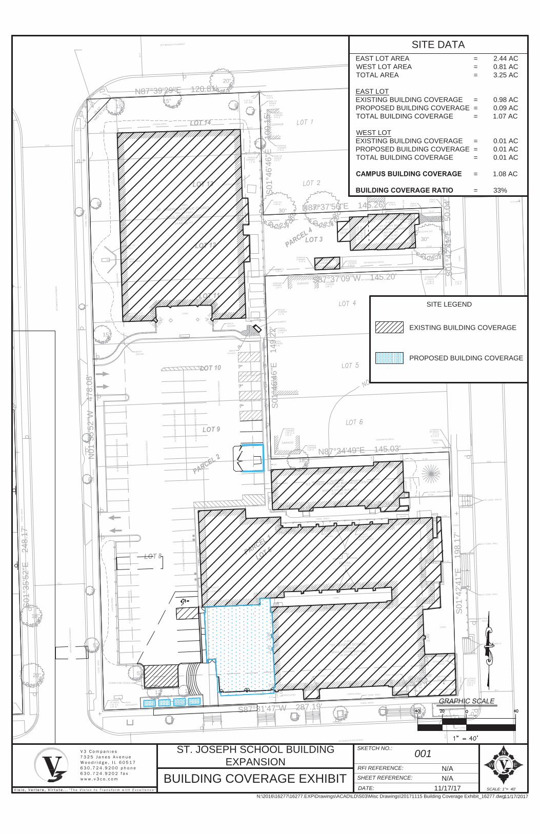
20"
18"
10"12"
5"
15"
9"
3"
8"
2"
3"
5"
3"
15"15"
20"
7"8"
7"7"
9"
12" 3" 5"
15"
18"
30"
30"30"
10.9
4'
4.34'
1.0
1'
94.83'
4.1
1'
1.00'
18.0
5'
1.25'2.4
6'
8.1
3'
1.25'2.4
5'
30.0
9'
1.08'2.45'
1.25'
2.4
5'
1.0
8' 20.00'
0.9
0'
14.00'
0.9
0'
56.00'
0.9
0'
21.50'
1.0
8'
0.67'1.8
3'
7.00'
1.0
8'
2.4
5' 1.25'
2.45'1.08'
16.9
0'
1.08'
2.4
5'
12.6
0' 2
.45'
1.08'
26.6
3'
10.14'
17.6
0'6.70'
14.8
0'
6.70'
37.0
8'
35.94'
3.0
8'
12.95'
2.0
5'
2.05'
2.0
5'
12.66'12.56'12.57'12.59'12.55'2.0
8'
1.38'
6.8
6'
28.50'
8.0
0'
38.25'
78.1
7'
47.24' 4.6
9' 19.81'
4.7
2' 13.84' 12.64' 12.59' 12.56' 12.59' 13.04'
DETAIL(TYPICAL)
# 4832
"ST. JOSEPH SCHOOL"
2 STORY
BRICK & STONE BUILDING
20,209 SQ.FT.
# 4824
"ST. JOSEPH PARISH BUSINESS CENTER"
2 STORY
BRICK & STONE BUILDING
3,598 SQ. FT.
GARAGE
# 4801
"ST. JOSEPH CATHOLIC CHURCH"
TALL 1 STORY
BRICK, STEEL AND GLASS
BUILDING
14,880 SQ. FT.
GARAGE
GARAGE
# 4804
2 1/2 STORY BRICK
BUILDING WITH BASEMENT
1,503 SQ. FT.
T/F=729.82
FF=730.50
2.2
6'
42.50'
2.2
5'
11.52'
2.2
5'
21.44'
32.2
2'
83.87'
2.9
4'
23.80'
30.0
2'
4.00'
6.7
0'
14.25'
0.7
9'
13.96'
2.00' 2.00
'
1.70'
9.1
5'1.
70'9.30' 1.7
0'
19.50' 9.30'1.70'
19.1
3'
1.70
'
2.00' 2.00
'
25.60'
153.9
7'
99.97'
153.9
7'
25.60'
GARAGE
BITUMINOUS DRIVE
BITUMINOUS DRIVE
CO
NC
. W
ALK
CO
NC
.
CO
NC
. W
ALK
CO
NC
. W
ALK
CO
NC
. W
ALK
CONC. WALK
8" CONC. WALL
14" CONC. WALLS
8" CONC. WALLS
17" CONC. WALLS
8" CONC. WALL
W/STEEL RAILING
BRICK
EDGING
BRICK
EDGING
BRICK
PAVERS
CONC.
CONC. WALK
CONC.
CONC.
CO
NC
. W
ALK
8" CONC. WALLS
W/STEEL RAILING
12" CONC. WALLS
12" CONC. WALL
12" CONC. WALL
8" CONC. WALLS
8" CONC. WALLS
GRATE
PLANTER
PLA
NT
ER
ST
AIR
WE
LL
PLA
NT
ER
LA
ND
SC
AP
ED
GR
AT
EG
RA
TE
PLA
NT
ER
SIGN
MONUMENT
CO
NC
. W
ALK
CONC. WALK
LA
ND
SC
AP
ED
LA
ND
SC
AP
ED
LANDSCAPED
BIT
UM
INO
US
PA
VE
ME
NT
CONC.
RAMP
AUTO
SPRINKLER
BIT
UM
INO
US
PA
VE
ME
NT
BRICK WALL
GENERATOR
LANDSCAPED
LANDSCAPED
8" CONC. WALL
1.7
0'
SIGN
MONUMENT
R.R. TIE
WALL
WOOD RAIL
FENCE
LA
ND
SC
AP
ED
AREA 6.6'
LOWER THAN
WALK GRADES
STEEL
RAILING
STEEL
RAILING
LANDSCAPED
CONCRETE DRIVE
35.3
'
28.0
'
28.8'
28.5'
43.2'
43.1'
BIT
UM
INO
US
PA
VE
ME
NT
BIT
UM
INO
US
PA
VE
ME
NT
BITUMINOUS PAVEMENT
0
2.71' W
3.04' E
WOOD
DECK
WOOD
PORCH
BITUMINOUS PAVEMENT
N87°39'29"E 120.81'
S01°4
6'4
6"E
100.1
5'
N87°37'56"E 145.26'
S01°4
2'4
1"E
50.0
4'
S87°37'09"W 145.20'S
01°4
6'4
6"E
149.2
2'
N87°34'49"E 145.03'
S01°4
2'4
1"E
198.1
7'
S87°31'47"W 287.19'
N01°3
5'5
2"W
478.0
8'
N43
°01'49
"E
28.4
7'0.10' E &ON LINE
0.63' N &0.30' W
0.63' N &0.30' W
GARAGECORNER5.52' E
GARAGECORNER5.76' E
END OFFENCE0.6' E
END OFFENCE0.8' E
FENCECORNER
1.2' W
3.3
1' 3
.56'
6.9
9'
7.1
6'
22.17'
22.04'
GARAGECORNER
3.74' N GARAGECORNER3.25' N
GARAGECORNER1.44' S
GARAGECORNER
1.18' S
WALK0.29' N
WALK0.78' N
WALK1.58' E
CORNEROF DRIVE
1.98' N&1.48' E
GARAGECORNER3.49' N
GARAGECORNER3.96' N &3.41' E
5.9
5'
6.0
0'
8.86'
CORNEROF DRIVE
3.71' N& 2.14' E
1.27' E
0.12' N1.22' E
14.93'
14.98'
23.15'
8.97'
8.70'
37.59'
37.59'
24.37'
24.25'
29.8
0'
16.67'
16.98'
RLK
SE
S01°3
5'5
2"E
248.1
7'
CORNEROF WALK1.26' S &1.05' W
CORNEROF WALL0.33' S &1.14' E
WALK0.98' W
WALK0.37' N
WALK0.23' N
FENCECORNER1.1' W
FENCECORNER2.4' W
28.6
3'
28.7'
1.76' E
FENCECORNER1.1' W
FR
AM
E
AD
DIT
ION
T/F
=730.7
2
CHAIN LINK FENCE
STONE
WALL
CLEAN OUT
CLEAN OUT
GEATE
GENERATOR
MONUMENT
CLEAN OUT
SCALE: 1"= 40'
BUILDING COVERAGE EXHIBIT
ST. JOSEPH SCHOOL BUILDING
EXPANSION
DATE:
SHEET REFERENCE:
RFI REFERENCE:
SKETCH NO.:001
N:\2016\16277\16277.EXP\Drawings\ACAD\LD\S03\Misc Drawings\20171115 Building Coverage Exhibit_16277.dwg11/17/2017
SITE DATA
EAST LOT AREA = 2.44 AC
WEST LOT AREA = 0.81 AC
TOTAL AREA = 3.25 AC
EAST LOT
EXISTING BUILDING COVERAGE = 0.98 AC
PROPOSED BUILDING COVERAGE = 0.09 AC
TOTAL BUILDING COVERAGE = 1.07 AC
WEST LOT
EXISTING BUILDING COVERAGE = 0.01 AC
PROPOSED BUILDING COVERAGE = 0.01 AC
TOTAL BUILDING COVERAGE = 0.01 AC
CAMPUS BUILDING COVERAGE = 1.08 AC
BUILDING COVERAGE RATIO = 33%
N/A
N/A
11/17/17
SITE LEGEND
EXISTING BUILDING COVERAGE
PROPOSED BUILDING COVERAGE


Bric
kGl
ass
Met
al C
ross
Tran
sluce
nt P
anel
Cano
pyLa
ndsc
ape
Wal
lCo
ncre
te R
etai
ning
Wal
lLi
mes
tone
Trim
NEW
OLD
NEW
OLD

Outd
oor C
lass
room
Futu
re S
hrin
e
Met
alCr
oss
Seat
ing
Bay
Land
scap
eW
all
Land
scap
e Ro
ofSt
uden
t Gar
den
Stud
ent G
arde
nSo
uthw
est V
iew
Exist
ing
Juni
or H
igh
Futu
re S
ign
and
Shrin
eOut
door
Cla
ssro
om
Seat
ing
Bay
Gree
n Ro
ofSe
curit
y Ve
stib
ule
Land
scap
e W
all
Ram
p
Shad
ing/
Light
She
lf
Stud
ent G
arde
n
Tras
h En
closu
re
Exist
ing
Elem
enta
ry
Mai
n St
reet
Fran
klin
Str
eet
Exist
ing
Park
ing
Build
ing
Port
ion
Cont
aini
ngCl
assr
oom
s and
Offi
ces
Build
ing
Port
ion
Cont
aini
ng S
tairs
, Res
troo
ms,
Elev
ator
, Equ
ipm
ent,
etc.
Met
al C
ross
Relo
cate
d W
indo
w&
New
to M
atch
