vinalhaven, maine resilience strategy
TRANSCRIPT

Vinalhaven: Turning the TideDesign & Resiliency Team (October 2017)

Design & Resiliency Team (DART)
• Wayne Feiden, FAICP, Director of Planning & Sustainability, Northampton, MA
• Cori Burbach, Assistant City Manager, City of Dubuque, Iowa
• Michael Davis, FAIA LEED AP, Bergmeyer Associates; Boston Civic Design Commission
• Peter Flinker, ASLA AICP, Principal, Flinker and Dodson
• David Kriebel, PhD, PE, Professor of Coastal and Ocean Engineering, US Naval Academy
• Joel Mills, Senior Director, Communities by Design, AIA
• Erin Simmons, Senior Director, Design Assistance, AIA
• Binh Minh Hoang (Vietnam) & Idfi Septiani (Indonesia), YSEALI

Vinalhaven Plans


Vinalhaven Speaks


Older and Aging, but finally stable

Shorter CommutesLonger LivesLivable

Economy: 1st Fishing, 2nd Tourism

Today

Tomorrow

Today

Tomorrow

Social Resiliency:
• Accessible housing choices for all residents
• Maintaining the experience of a close-knit community• Who’s living here?
• Community Center
• Playground
strengthening neighborhood-level relationships and increasing community resilience, specifically in regards to emergency preparedness as well as disaster response and recovery
• Building a diverse economy• Recruiting young entrepreneurs• Keeping our kids here: job training to fit
the needs of the island• Infrastructure support: buildings &
technology

Housing AffordabilityVinalhaven residents are spending 20.2% of income on housing.

Knox County Housing Cost Burden
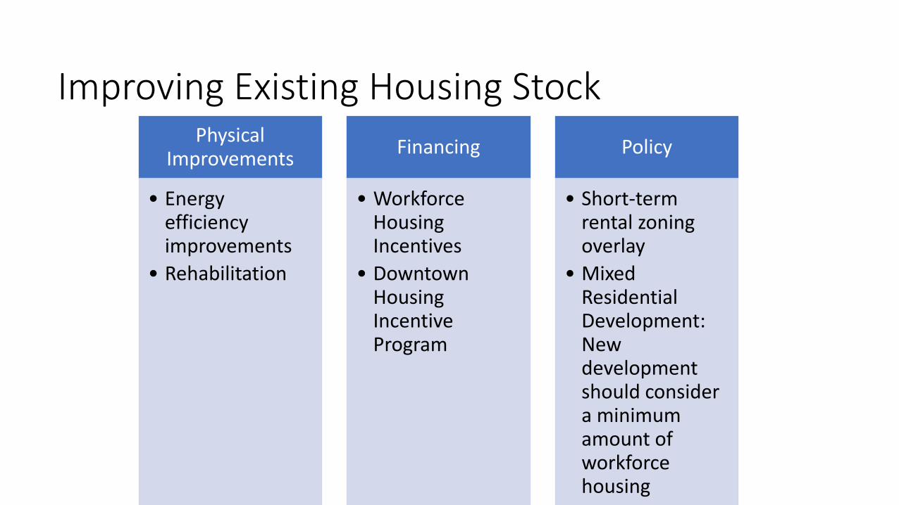
Improving Existing Housing StockPhysical
Improvements
• Energy efficiency improvements
• Rehabilitation
Financing
• Workforce Housing Incentives
• Downtown Housing Incentive Program
Policy
• Short-term rental zoning overlay
• Mixed Residential Development: New development should consider a minimum amount of workforce housing

New Housing Creation


Housing Financing Options
First-time Home Buyers Program• $5,000 loan for those making 80% of
median income
• $25,000 loan for 30% of median income
• 0% interest
• Required to participate in home ownership workshop

Age-Friendly Community
AARP Livability Index:
Housing: 50
Neighborhood: 36
Transportation: 47
Environment: 67
Health: 50
Engagement: 91
Opportunity: 53

What might the aging need to stay on the island?• Walkable neighborhood
• Accessible, affordable housing
• Medical care: telemedicine, pharmacy
• Transportation: car sharing program, taxi service
• Engagement: community center opportunities
• Part-time job opportunities

Building a Connected Community


Mobile Community Center/ Activated Park Spaces


Net Zero Island
graywater capture
solar (rooftop + community)
solar hot water heating
school compost program
hike/bike trail
EV charging stations


Zero Waste Community
Everyone has the easily-accessible opportunity to recycle and compost at home, at work, and at school.


Sustainable Agriculture
• Beginning farmers & fisherman are entrepreneurs.
• Opportunities for value-added products.
• Expansion of opportunities through shoulder-season agriculture.
• Edible landscaping.
• Explore opportunities to build community around food.


“We shouldn’t have to deal with
infrastructure to run our businesses.”
“People have to be able to
live here.”
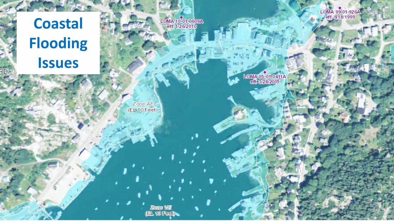
Coastal Flooding
Issues

Coastal Flooding Threats• Storm Tides
• Feb 1978 Storm of Record +9.7 ft
• FEMA Zones AE 10 and VE 13
• Nuisance Flooding• King Tides
• Nov 2016 +7.6 ft
• Sea Level Rise• Pushing high (King) tides higher
• Projections for future sea level rise

Ransom Engineering
Study
100-year Storm Surge and Waves
Town should consider map amendment or change

Nuisance FloodingAnnapolis and US Naval Academy
Dec 2012The Weather Channel
Late 1980’s: 1 flood every 3 years
2015-2017: 15 to 20 floods per year

Sea Level RiseMeasured mean sea level at Bar Harbor
and Projections for Future

Maine Geological SurveyCoastal Hazards
Sea Level Rise and Storm Surge
• Highest Annual Tide (HAT)• Regulatory Boundary for
Shoreland Zoning Act
• HAT is about the same as the Nov 2016 King Tide
• State maps show HAT plus sea level rise
• Consider elevation transect across Main Street
HAT+2 ft

Transect Present Condition
Storm = Nov 1978 and FEMA Base Flood Elevation
Nuisance = Highest Annual Tide (HAT) and Nov 2016 King Tide
Normal High = Mean Higher High Water
Main StreetParking Lot
Pond

Transect 1 foot Sea Level Rise
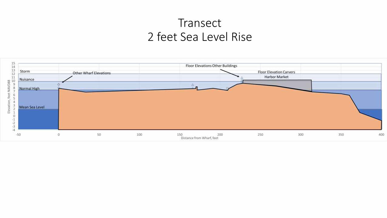
Transect 2 feet Sea Level Rise

Transect 3 feet Sea Level Rise

Response to Coastal Flooding
Armor, Adapt, or AbandonConsider Town’s Positives and Negatives
Positives• No ground subsidence• Low historic rate of SLR• Storm surge elevation relatively low • Large % of harbor shoreline is wharf
with parking• Buildings are light wood frame• Single road• Stormwater can drain two directions
Negatives• Porous grout and granite block • Sluice structure connecting Carvers Pond• Downtown is a peninsula• Large % of Pond shoreline is privately
owned• Wood frame buildings limit floodproofing
options
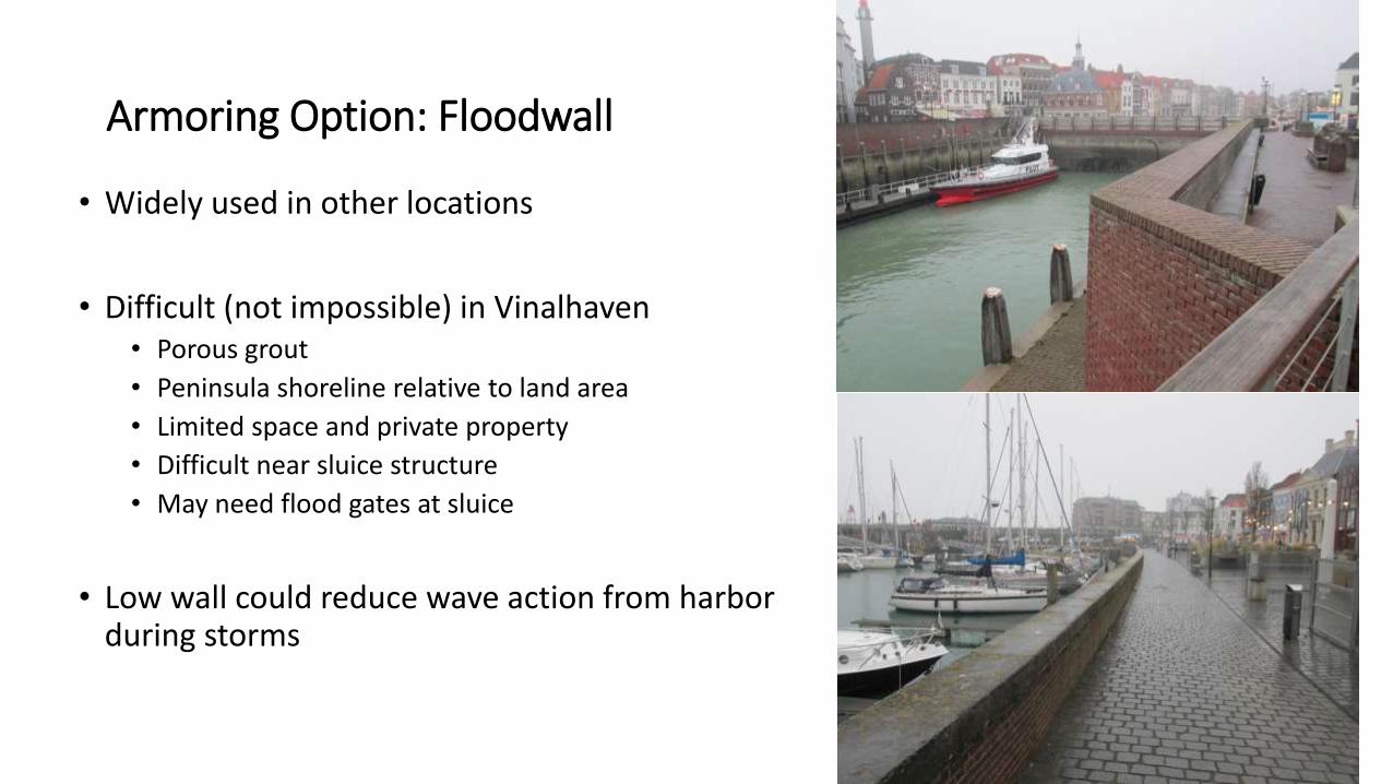
Armoring Option: Floodwall
• Widely used in other locations
• Difficult (not impossible) in Vinalhaven• Porous grout
• Peninsula shoreline relative to land area
• Limited space and private property
• Difficult near sluice structure
• May need flood gates at sluice
• Low wall could reduce wave action from harbor during storms

Adaptation Option:Dry Floodproofing
• Can be low cost• Would work for low flood levels and wave effects• Would work if Pond level not a high as harbor level• Difficult with light wood frame buildings

• Individual action of each property owner
• Can be low cost
• Does not prevent all flood damage but adds resiliency
Adaptation Option:Wet Floodproofing

Adaptation Option:Raise Roads (and Wharfs)
• Appears to be an appropriate action for Town
• Being done in other locations
• Cost effective public works approach to resiliency
• Best done as part of overall revitalization or life cycle upgrade

Adaptation Option:Raise Buildings
• Appears to be an appropriate action
• Being done in other locations
• Action for property owner, unless Town can coordinate
• Cost effective, especially with reduction in FEMA flood insurance

Improving Resiliency to Coastal Flooding
• Near term (to 2050):• Elevate road and sidewalks
• Prevent nuisance flooding with 1 ft SLR scenario• Need to evaluate stormwater and sewer
• Encourage prudent wet or dry floodproofing measures
• Long term (to 2100):• Consider long term plan to raise wharf elevations • Consider modifying sluice structure• Consider long term plan to raise buildings
• First floor above future FEMA base flood elevation
• Take advantage of life cycle replacement and upgrades

THE CONCEPT

MAIN/WEST MAIN STREET WITH MULTIUSE TRAIL AND COMPLETE STREETS

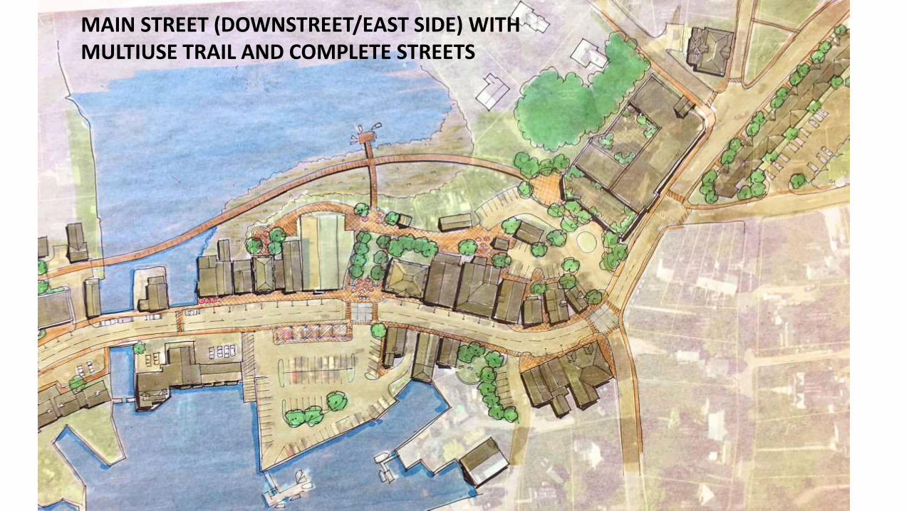
MAIN STREET (DOWNSTREET/EAST SIDE) WITH MULTIUSE TRAIL AND COMPLETE STREETS

SIDEWALK AND STREET TODAY

ACCESSIBLE AND RAISEDSIDEWALK AND STREET

ENHANCEMENTS TO FERRY TERMINAL

DEVELOPMENT OPPPORTUNITIESBETWEEN THE FERRY TERMINALAND DOWNSTREET


“WELCOME TO DOWNSTREET”INTERSECTON OF HIGH & MAIN

ADDITION TO CAMDEN NATIONAL BANK.INTERSECTION ENHANCED FOR TRAFFIC CALMING, ACCESSIBILITY, SENSE OF PLACE
MAIN STREET (DOWNSTREET/EAST SIDE) WITH MULTIUSE TRAIL AND COMPLETE STREETS

CONSTRUCTED WETLANDS, MULTI-USE PATH,AND MICRO-HYDRO ON CARVER’S POND

NEW PARK AT DOWNSTREET CENTER

MAIN STREET WITH ENHANCED INFRASTRUCTURE, ROAD SURFACE AND NORTH SIDEWALK RAISED

MAIN STREET WITH ENHANCED INFRASRUCTUREAND 100-YEAR FLOOD

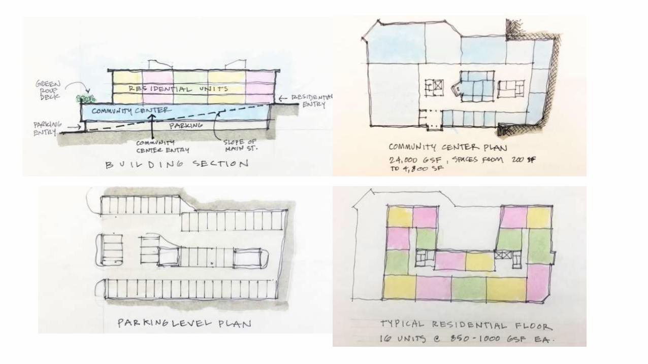
NEW WORKFORCE HOUSING AND COMMUNITY CENTER

NEW WORKFORCE HOUSING & COMMUNITY CENTERAT WATER AND MAIN STREETS

NEW WORKFORCE HOUSING AT EAST MAIN AND CHESTNUT STEETS


Making it Happen: First Steps to FundingProject Opportunity Next Steps
Main/West Main Streets, sidewalks, and multiuse path
MaineDOT1. Statewide Transportation Improvement Program (STIP) 2. Bicycle & Pedestrian Funding
1. Certification as a “Qualifying Pedestrian Area” 2. Start STIP process3. Explore funding options
Sidewalks and accessibility, community center, flood control
Maine CDBG (Housing Assistance, Downtown Revitalization, Public Facilities, & Public Infrastructure)
Focus on downtown, new housing, and benefits to Harborside, John Carver, and Hillside Apartments and
All projects Maine Community Foundation Explore opportunities, especiallyfeasibility funding
Community Center Housingcomponent
Tax Increment Financing (TIF) Explore TIF for any private development above community center to cover infrastructure
Flood mitigation FEMA Hazard Mitigation Grant Cost-benefit analysis
Multiuse Trail Federal Land & Water Conservation Fund Explore funding

Making it Happen: First Steps for PartnershipsProject Opportunity Next Steps
Quick starts Quick starts all projects that requirelimited resources.
Organize volunteers start today!
Next steps Identify priorities from presentation Set town priorities from DART. Start today!
Community Center housingcomponent
Housing developers & investment funds
Explore a willingness to partner for upper floor housing
Multiuse path and downtown revitalization
Explore with property owners Explore-no purchase for projects with future federal transportation dollars
Portable community trailer Trailer Explore options for donation of used trailer
Flood mitigation Coordinate with Vulnerability Assessment
Use DART to influence Assessment
Lower flood insurance rates FEMA Community Rating System Apply: 10-15% discount 1st round, more with mitigation actions
