visitor experience and resource protection … the visitor experience and resource protection (verp)...
TRANSCRIPT

VERP The Visitor Experience and Resource Protection (VERP) Framework
A Handbook for Planners and Managers
U.S. Department of the Interior • National Park Service
VERP The Visitor Experience and Resource Protection (VERP) Framework A Handbook for Planners and Managers
September 1997U.S. Department of the Interior • National Park Service • Denver Service Center
Contents
HOW TO USE THIS HANDBOOK 1Organization of the Handbook 3
HISTORY AND THE DEVELOPMENT OF THE CARRYING CAPACITY CONCEPT 4Introduction 4The Concept of Carrying Capacity 4Limits of Acceptable Change 5
OVERVIEW OF THE VERP FRAMEWORK Purpose of the VERP Framework 8Summary of the Framework 9VERP and NPS Planning 11VERP and NEPA 12
ELEMENT 1Assemble an Interdisciplinary Project Team
Pointers for Building the Team 13
ELEMENT 2Develop a Public Involvement Strategy 15
8
13
Pointers for Developing a Public Involvement Strategy 18
ELEMENT 3Develop Statements of Park Purpose, Significance, and Primary Interpretive Themes;Identify Planning Constraints 19
Identification of Park Purpose and Significance 20Pointers for Developing Park Purpose Statements 21Examples of Park Purpose Statements 21Pointers for Developing Park Significance Statements 22Examples of Park Significance Statements 24
Identification of Primary Interpretive Themes 25Pointers for Articulating Primary Interpretive Themes 26Examples of Primary Interpretive Themes and Park Themes 26
Identification of Planning Constraints 28
iii
��������
Pointers for Identifying Planning Constraints 28Examples of Planning Constraints 29
ELEMENT 4Analyze Park Resources and the Existing Visitor Use 30
Analysis as It Relates to VERP 30Pointers for Analysis 32
Experiential Resource Analysis 33Pointers for Experiential Resource Analysis 38
Existing Use and Facilities Analysis 38Pointer for Existing Use and Facilities Analysis 39
Resource Concerns / Resource Sensitivity Analysis 40Pointers for the Resource Concerns / Resource Sensitivity Analysis 41
ELEMENT 5Describe a Potential Range of Visitor Experiences and Resource Conditions 42
Importance of Diversity 42Identifying the Range of Potential Resource Conditions and Visitor Experience 43
Example of Zone Descriptions from Arches National Park 46Example of Zone Description from Isle Royal National Park — Motorized SensitiveWater Zone 47
Pointers for Determining the Range of Resource Conditions and Visitor Experiences 48
ELEMENT 6Allocate the Potential Zones to Specific Locations in the Park (Prescriptive Management Zoning) 51
Examples of VERP Zoning 52Pointers for Developing Management Zoning 52Development of Alternatives 56Pointers for Developing Alternatives 57
ELEMENT 7Select Indicators and Specify Standards for Each Zone; Develop a Monitoring Plan 58
Definition of Indicators and Standards 58Indicators 60
Sources of Indicators 60Characteristics of Good Indicators 62Selection of Indicators 64
Standards 67Characteristics of Good Standards 67Setting Standards 69
Examples of Possible Indicators and Standards 70Revision of Indicators and Standards 70Pointers for Developing and Selecting Indicators and Standards 72Development of a Monitoring Strategy 74
Key Components of a Monitoring Strategy 75Where Resource and Social Indicators Should Be Monitored 76When Indicators Should Be Monitored 78How Resource and Social Indicators Should Be Monitored 79
iv
Contents
ELEMENTS 8 & 9 Monitor Resource and Social IndicatorsTake Management Action 81
Monitoring 81Range of Possible Management Actions 82Pointers for Selecting Management Tactics 85
APPENDIX ADescriptions of the Resource Experience Opportunity Areas Developed for the Arches VERP Plan 87
APPENDIX BDescriptions of the Management Zones in the Arches VERP Implementation Plan 90
GLOSSARY 96
BIBLOGRAPHY 97
LIST OF PREPARERS 103
FIGURES
1. Planning Corral 192. Resource Experience Opportunity Areas, Arches National Park 363. Parkwide Management Zones, Arches National Park 534. Windows Sector Management Zones, Arches National Park 54
TABLES
1. Resource Experience Attributes for Visitor Use 372. Potential Management Zones, Arches National Park 453. Summary of the Arches National Park VERP Zones 554. Example of an Evaluation Matrix for Selecting Indicators 665. Examples of Indicators and Standards 71
v
How To Use this Handbook
In 1992 the National Park Service (NPS) began developing the Visitor Experience and Resource Protection (VERP) frame-
work to address visitor use management and carrying capacity issues in the units of the national park system. Arches National Park was the first unit in which the VERP process was tested. Interest in the VERP framework in the National Park Service has subsequently soared, and additional applications are now underway in several park units. Interest has also been expressed by other management agencies both in this country and internationally.
This handbook is intended to provide sufficient guidance so that a NPS planner, resource manager, or other practitioner assigned to undertake VERP planning can do so with confi
dence. However, even with this handbook a practitioner will need to have initiative and creativity, be willing to experiment, and be able to make judgement calls in order to successfully carry out a VERP effort. Frequent communication with indi
viduals involved in other VERP efforts may also be helpful.
It must be stressed that this handbook is not meant to be a com
plete guide on how to do general planning for parks. Many impor
tant topics that should be considered in the development of park plans, such as the treatment of issues, public involvement, and the assessment of alternatives, are discussed briefly or not at all. Readers should refer to the NPS Park Planning Guidelines and the Park Planning Sourcebook (both in preparation) for more details on park planning.
Due to the timing of the production of these three documents, there may be inconsistencies and contradictions in terminology and directions contained in the documents. In these cases, read
ers should defer to the guidance provided in the Park Planning Guidelines.
1
� �������� ��� �������� ��� ��������
This Handbook is . . . — a general guide to the elements that make up the VERP framework. It
defines the elements, explains their relationships to each other and to planning, suggests some terminology, and shares current insights into the successes and potential pitfalls in applying VERP.
— about a new way of addressing visitor use (carrying capacity) issues in parks. The VERP framework is a methodology for visitor use planning and management. Many of the VERP elements are also elements of general management planning.
— intended to provide overall consistency in the application of the VERP methodology so that the framework can evolve and improve in an orderly way.
— a compilation of many ideas and approaches that are new and/or experimental to the Park Service. As the VERP framework is tested in more park areas, this handbook will need to be updated.
This Handbook is not . . . — a step-by-step guide on how to apply VERP. It is not possible for this
handbook to answer all the questions that arise over the application of the VERP framework in every park.
— a description of a substitute or alternative general management planning process, although the VERP framework may be used in conjunction with general management planning.
— intended to provide a recipe that requires that the VERP framework be applied exactly the same way in every park unit.
— the final word on the VERP process. It will often be up to the practitioner to choose a course of action deemed best for each park situation. We are still learning how to implement the VERP framework.
2
How to Use This Handbook
ORGANIZATION OF THE HANDBOOK
The first two chapters of this handbook give an overview of the carrying capacity concept and the VERP framework. The remaining chapters are organized by nine VERP framework ele
ments. Generally each of these chapters describes the purpose or role of the element, describes what it is, provides examples, and offers pointers on how to complete the elements. These chapters vary considerably in their level of detail, depending on how familiar planners/managers are with the element. At the end of the handbook there is a glossary of terms and a list of key sources of additional information.
3
History and Development of the Concept of Carrying Capacity
The Purpose of the National Park Service
conserve the scenery and the natural
and historic objects and the wild life
therein
provide for the enjoyment of the same in
such manner and by such means as will
leave them unimpaired for the
enjoyment of future generations
— 1916 NPS Organic Act (16 USC 1)
The national parks� contain natural and cultural resources of great importance to the nation and, in many cases, to the inter-
national community. Given the significance of this resource base, public demand to see and experience these areas should not be surprising. In the decades of the 1970s and 1980s, visita
tion increased tremendously in the national park system. In the 1990s the increase in visitation has slowed, but use levels are still rising in many parks. This upward trend is expected to continue into the next century.
The increasing visitation to the national park system is making it more difficult for the National Park Service to fulfill its dual mission to provide for the enjoyment of national parks while conserving resources for future generations. Concern over rising visitation in parks, and accompanying impacts on resources and on visitor experience, has led the National Park Service to focus increasing attention on the concept of carrying capacity.
THE CONCEPT OF CARRYING CAPACITY
The underlying concept of carrying capacity has a rich history in the natural resource professions. In particular, it has proven a useful concept in wildlife and range management where it refers to the number of animals of any one species that can be main
tained in a given habitat. Carrying capacity has obvious parallels and intuitive appeal in the field of park management. In fact, it was first suggested in the mid–1930s as a park management con
cept in the context of the national park system. However, the first rigorous application of carrying capacity to park planning and management did not occur until the 1960s.
�� ��� ���� ������ �� ���� �������� ������ �� ��� ����� �� ��� �������� ���� ������ ������ �������� ���������� ���������� ��������� ���������� ���������� ������ ���� ��� ������ ������� �������� ������ �������� ������ �����
4
History and Development of the Concept of Carrying Capacity
The initial scientific applications of carrying capacity in parks focused on the impacts on park resources resulting from visitor use. It soon became apparent, however, that there was another dimension of carrying capacity dealing with the social aspects of the visitor experience. In the 1964 monograph The Carrying Capacity of Wild Lands for Recreation, J. A. Wagar reported that his study “was initiated with the view that the carrying capacity of recreation lands could be determined primarily in terms of ecology and the deterioration of areas. However, it soon became obvious that the resource–oriented point of view must be augmented by consideration of human values.”
The point was that as more people visit a park, both the natural and cultural resources of the area and the quality of the visitor experience can be affected. Through the years it has become evident that there is a conflict between Park Service efforts to encourage the use of parks by making them more accessible to more people, and its efforts to ensure that park resources are protected and opportunities for quality visitor experience opportunities are provided.
LIMITS OF ACCEPTABLE CHANGE (LAC)
The early scientific work on carrying capacity has blossomed into an extensive literature base on resource and social aspects of park use and their application to carrying capacity (for exam
ples, see the Bibliography). But despite the impressive literature base, efforts to determine and apply carrying capacity to parks have often resulted in frustration. The principal difficulty lies in determining how much resource or social impact is too much. Given the substantial demand for public use of the parks, some decline or change in resource condition and the quality of visitor experience is inevitable. But how much decline or change is appropriate or acceptable? This issue is often referred to as the limits of acceptable change (LAC) and is fundamental to addressing carrying capacity.
In 1985 the U.S. Forest Service published a process for dealing with the issue of recreational carrying capacity in wilderness. The process was first applied at the Bob Marshall Wilderness Complex in Montana. Since that time several planning and management frameworks have been developed to address carry
ing capacity, including the National Parks and Conservation Association Visitor Impact Management (VIM) process, the Parks Canada Management Process for Visitor Activities (known as VAMP), and the Park Service VERP process. While each framework includes refinements to suit individual agency
5
� �������� ��� �������� ��� ��������
missions, policies, and procedures, all of the frameworks share a common set of elements. All of these frameworks include a description of desired future conditions for park resources and visitor experiences, the identification of indicators of quality experiences and resource conditions, establishment of standards that define minimum acceptable conditions, the formulation of monitoring techniques to determine if and when management action must be taken to keep conditions within standards, and the development of management actions to ensure that all indi
cators are maintained within specified standards.
Another way of looking at the basic logic of the LAC process and other frameworks has been articulated by David Cole of the Aldo Leopold Wilderness Research Institute and one of the original authors of the LAC concept. According to Cole, the intent of carrying capacity planning is to develop a compromise between the absolute protection of resources (in this case refer-
ring to the environmental conditions and the visitor experience) and the unrestricted access to resources for recreational use. The LAC process was designed to help define this compromise.
The basic logic of the LAC process, according to Cole, is as follows:
• Identify Two Goals in Conflict. In the case of national parks, the two goals are usually the protection of environ
mental conditions and visitor experiences (goal 1) and the unrestricted access to resources for recreational use (goal 2).
• Establish that Both Goals Must Be Compromised. If one or the other goal cannot be compromised, then the LAC process is not needed — one goal must simply be com
promised as necessary to meet the one that cannot be compromised.
• Decide Which Goal Will Ultimately Constrain the Other. In the case of national parks, the goal of protecting envi
ronmental conditions and visitor experiences will almost always constrain the goal of unrestricted access.
• Write LAC Standards for this Ultimately Constraining Goal. LAC standards express the minimally acceptable conditions for the environment and visitor.
6
History and Development of the Concept of Carrying Capacity
• Compromise this Goal Until the Standards Are Reached. Allow the environmental conditions and visitor experi
ences to degrade only to the minimally acceptable stan
dard. Recreational access should not be substantially restricted until the standards are reached.
• Compromise the Other Goal as Much as Necessary. Once standards for environmental conditions and visitor experiences are reached no more degradation is allowed, and recreational access is restricted as needed to main
tain standards.
Looking at the basic logic of the LAC process in this way is helpful for several reasons. First, this way of thinking illustrates that the fundamental challenge in visitor use management is not so much the resolution of resource protection and visitor use conflicts. Instead, the emphasis should be on defining comple
mentary visitor experience opportunities and resource condi
tions, and then determining to what extent unrestricted recreational access can be accommodated. Second, this logic allows managers to recognize that unrestricted access — a value held strongly by many recreationists — is a valid goal, but one which cannot always be accommodated in light of the equally valid goals of visitor experience diversity and resource protec
tion. Third, an understanding of the generic thought process is helpful in understanding how the various frameworks may be adapted or fine-tuned for different situations without losing the critical elements of the frameworks. Fourth, because there has been interest on the part of managers to apply the LAC process to problems other than carrying capacity, the examination of the generic process helps in determining the situations in which such applications may be useful and those situations in which they may not.
Since the inception of the LAC process, land area managers and planners have continued to test, adapt, and refine the process. The VERP framework is one of the adaptations of the LAC process. In VERP planning, the process is expanded to address a wide variety of resource settings and frontcountry as well as backcountry experiences.
7
Overviewof the VERP Framework
PURPOSE OF THE VERP FRAMEWORK
Under the 1978 National Parks and Recreation Act (P.L. 95-
625), the National Park Service is required to address the issue of carrying capacity in its general management plans (GMP). NPS management policies and planning guidelines acknowledge this responsibility. The concept of carrying capacity is intended to safeguard the quality both of the park resources and the visi
tor experience. Park resources in this context encompasses all of the biophysical, aesthetic, and cultural elements and features contained in a park.
As it applies to parks, visitor carrying capacity is defined as “the type and level of visitor use that can be accommodated while sustaining acceptable resource and social conditions that com
plement the purpose of a park.”
Under this definition carrying capacity is interpreted primarily as a prescription of resource and social conditions, and secon
darily as a prescription for the appropriate numbers of people.
Inherent in the above definition are the understanding of the purpose of a park and the development of management pre
scriptions specifying appropriate resource and social conditions. Another basic assumption is that carrying capacity work is undertaken with the intent of managing visitor use. Visitor use management begins with a plan, but it continues as an cyclical process involving monitoring, evaluation, and taking action to make adjustments.
Discussions about the appropriate focus and scope of efforts have led to the following working definition. VERP is:
8
Overview
a planning and management framework that focuses on visitor use impacts on the visitor experience and the park resources. These impacts are primarily attributable to visitor behavior, use levels, types of use, timing of use, and location of use.
It should be noted that crowding is only part of what contributes to or takes away from the visitor experience. However, it is the rapidly increasing visitation in many parks that is driving the interest in and the need for using the VERP framework. Man
agers have other tools besides the VERP framework for evalu
ating the quality of park interpretation programs and the adequacy of facility maintenance, for example, even though these factors certainly influence the quality of the visitor experience.
SUMMARY OF THE FRAMEWORK
Nine elements are integral to the VERP framework. The ele
ments are summarized below; each element is discussed in fur
ther detail in subsequent chapters. While the scope of the elements, the order in which they are undertaken, and the spe
cific methods used to complete the elements may vary in differ
ent situations, all of the elements are necessary to implement a VERP program. Although the elements are numbered and may appear to follow a linear process, it is important to remember that the VERP framework is iterative, with feedback and “feed-
forward” occurring throughout the elements.
The VERP framework is intended to provide a logic and ration-
ale for making decisions on carrying capacity issues. It is, there-
fore, important to document all decisions that are made during the course of developing and implementing the VERP elements in a park. The documentation of rationale is particularly impor
tant when managers need to make controversial decisions, such as limiting visitor use or increasing development.
Framework Foundation
Element 1: Assemble an Interdisciplinary Project Team. A core team is needed and should include those people who can develop the plan and those who will implement the plan. A wide variety of consultants with various backgrounds and expertise may be needed to assist the core team.
Element 2: Develop a Public Involvement Strategy. As in any planning effort, the public must be involved in VERP planning.
9
� �������� ��� �������� ��� ��������
Both NPS staff and publics external to the agency should be considered. A public involvement strategy should be prepared early in the framework.
Element 3: Develop Statements of Park Purpose, Significance, and Primary Interpretive Themes; Identify Planning Con
straints. These statements form the foundation upon which the VERP plan and implementation strategies are built. All subse
quent elements must be consistent with and supportive of these statements. This element may already exist in many parks, hav
ing been developed in previous planning efforts. But if this work has not been done, the work on VERP elements should not con
tinue until all of these statements are articulated and clearly understood.
Analysis
Element 4: Analyze Park Resources and the Existing Visitor Use. The objective of this element is to understand as fully as possible park resources and existing visitor use and experience. This analysis should be documented, usually through a combina
tion of maps, matrixes, and text.
Prescriptions
Element 5: Describe a Potential Range of Visitor Experiences and Resource Conditions (potential prescriptive zones). Poten
tial zones are described by different desired visitor experience opportunities and resource conditions that could be provided in a given park, consistent with the park purpose and significance. The zone descriptions prescribe the appropriate kinds and levels of activity, development, and management. These potential zones are described in text only; they are applied to specific geo
graphical areas in element 6.
Element 6: Allocate the Potential Zones to Specific Locations in the Park (prescriptive management zoning). In this element the zones described in element 5 are assigned to specific locations in a park. The zoning scheme prescribes future conditions; it is not descriptive of existing conditions, although in some cases the continuation of existing conditions could be the desired future. If appropriate, the planning team should develop alter-
native zoning schemes and assess their beneficial and adverse impacts, consistent with the National Environmental Policy Act (NEPA).
10
Overview
Element 7: Select Indicators and Specify Standards for Each Zone; Develop a Monitoring Plan. Indicators (specific, measur
able variables that will be monitored) and standards (minimum acceptable conditions) are identified for each zone. A monitor
ing plan is developed that identifies priorities, methods, fund
ing, and staffing strategies and analysis requirements.
Monitoring and Management Action
Element 8: Monitor Resource and Social Indicators. The park staff regularly monitors resource and social conditions in vari
ous zones. Staff and funding limitations will usually necessitate setting priorities and monitoring indicators only in the most critical areas.
Element 9: Take Management Action. When monitoring indi
cates that social or resource conditions are out of standard or are deteriorating toward a standard, management action must be taken.
VERP AND NPS PLANNING
The VERP framework was conceived and designed to be part of the park GMP process. Indeed, many of the elements in the VERP framework, such as developing park purpose and signifi
cance statements and describing future conditions by individual management zones, will be integral to most park general man
agement plans. According to current NPS guidance, general management plans will qualitatively address carrying capacity by describing the visitor experience and resource condition by zone. Most future general management plans, therefore, will not contain further carrying capacity details. In most cases the more quantitative elements of the VERP framework — specify
ing indicators and standards, developing a monitoring strategy, and identifying management actions needed to address condi
tions when standards are reached or exceeded — will be accom
plished in an implementation plan that is developed after the completion of a general management plan.
There may be other situations where VERP planning will be applied outside of the GMP process. For example, it may be necessary at times to address visitor use issues for parks with older general management plans or to address visitor use issues in only one or two areas in a park. A separate visitor manage
ment plan or an amendment to an existing plan may be appro
priate in these cases.
11
� �������� ��� �������� ��� ��������
VERP and NEPA
All VERP planning, including the development and revision of standards and management actions and the development of a VERP implementation plan, is subject to the provisions of the National Environmental Policy Act. As much as possible, a deci
sion to pursue a VERP effort should be analyzed in the environ
mental documentation accompanying a general management plan. But often it may not be possible in a general management plan to predict the full range of management actions needed to implement a VERP effort or the consequences of those actions. In this case additional NEPA documentation may be needed to cover the standards and management actions in a VERP imple
mentation plan. If major or controversial actions are proposed after an implementation plan is completed, or a decision is made to revise indicators or standards, further NEPA documen
tation may be needed. (For further general guidance on when to apply NEPA compliance, readers should refer to the National Park Service National Environmental Policy Act Guidelines.)
12
Element 1 Assemble an Interdisciplinary Project Team
Planning is a complex challenge that should be accomplished by an interdisciplinary team. Careful thought needs to be given to selecting team members to ensure that the team has the neces
sary skills, knowledge, and expertise to develop and guide the implementation of a plan. A core team should be assembled consisting of
• a team leader/planner (someone to lead the team through the framework)
• a decision maker (superintendent or assistant superintendent)
• two or three key park staff/specialists
It is essential that all of these individuals be part of the core team. In addition to the core team members, a variety of con
sultants will likely participate at different points in the develop
ment of a plan.
POINTERS FOR BUILDING THE TEAM
� Park staff must play a major role in the development of a plan because they will be responsible for implementing it. If the plan is to succeed, it is important that the planning team culti
vate staff understanding of and ownership in the plan.
� Developing a plan may take a lot of time and effort. It is essential that before beginning work on a plan, the park superintendent and park staff are aware of the future work-
load requirements and are willing and able to make the needed time commitments. This commitment must be strong throughout the planning effort. If team members do not attend meetings, do not do assigned work, or drop off the team, the chances significantly increase that the plan will fail.
13
� �������� ��� �������� ��� ��������
(The ability of people to commit to team participation may be one of the criteria in selecting team members.)
� The core team should be kept relatively small (i.e., 3–7 mem
bers). It should include diverse perspectives and disciplines, and should represent a range of park staff and management.
� Since direction must be given to the planning team on numer
ous details, it is desirable to have the superintendent on the core team. In instances where the superintendent cannot sit in, the assistant superintendent should participate. In the lat
ter case, the superintendent should be regularly briefed on the status of the effort to avoid any surprises.
� The core team should rely on consultants to provide addi
tional skills and abilities. The number and types of consult-
ants and the duration of their involvement will vary depending on the core team’s needs and abilities and the characteristics of the park. Some of these consultants could be from outside the Park Service, including other agencies, stakeholders, and research institutions. Individuals who might participate in different planning projects or at different times on the same project include
• natural resource specialists
• cultural resource specialists
• resource managers
• interpretive specialists
• natural resource scientists
• social scientists
• geographic information system specialists
• public involvement specialists
• park maintenance specialists
• concession management specialists
• landscape architects
• writer/editors
• community planners
• facilitators
• state historic preservation officers
14
Element 2 Develop a Public Involvement Strategy
Parks have a great deal of symbolic value to the American public and are often the focus of intense emotions. Public involvement in the planning process helps the planning team to understand the values people hold in relation to park resources and the visitor experience and is critical to creating a plan that can be successfully implemented. Underlying all fundamental planning decisions are competing values, which must be resolved by a decision as to which value is of greater importance in this particular situation. A planning decision is the compro
mise between competing values at a given point in time. Under-
standing public values enables the planning team to make informed planning decisions.
Involving the public in the planning process helps a planning team to
• learn about public concerns, issues, expectations, and values
• educate people about the planning process, issues, and proposed management action
• learn about the values placed by other people and groups on the same resources and visitor experience
• collect data and validate proposals (e.g., information on public values and issues, on how people use a park, on existing and desired conditions, and on the acceptability of proposed indicators, standards, and management actions)
• define the range of alternatives
• build support among local publics, visitors, Congress, and others for implementing the plan
Developing a public involvement strategy is one of the planning team’s first tasks. The strategy should outline opportunities for
I know no safe depository of the
ultimate power of society but the people
themselves, and if we think them not
enlightened enough to exercise their
control with a wholesome discretion, the
remedy is not to take it from them, but
to inform their discretion by education.
— Thomas Jefferson
15
� �������� ��� �������� ��� ��������
public involvement throughout the planning effort and should be carefully and systematically designed as part of the decision-
making process. The public and the planning team should exchange information and ideas throughout the process, not just after decisions have been made. When this does not occur, pub
lic comment is likely to be received either too early or too late to be usable, or it may fail to focus on the critical issues.
The public needs to understand how their input will be used, how decisions will be made, and the consequences of potential management action. There should be a link between public comment and decision making, or the public will see no reason to participate.
The success in implementing a public involvement strategy depends upon preplanning and preparation. For each element in the plan it is important to know why the team is involving the public, what needs to be accomplished, and what information needs to be exchanged between the Park Service and the public. Only after these questions have been answered should the team determine which public involvement techniques would be most appropriate. The timing of public involvement events should be sensitive to the amount of information generated and the deci
sions made since the last time the team interacted with the public.
The planning team may need to actively solicit the views of some groups that might not otherwise participate and may need to explore alternative forms of public involvement that are sen
sitive to the groups’ needs and culture. It is important to involve as many people, organizations, and agencies as possible that may be affected by or have a stake in the outcome of planning and implementation decisions. All groups and individuals should have equal access to information as well as equal oppor
tunities to interact with the planning team.
Below are some factors that should be considered in identifying publics to involve in a planning process.
Proximity. People who live in the immediate area of the park may be affected by noise, the influx of people, or the changes in public use. Because of the national interest in parks, NPS managers must consider and balance information received from both local and national publics. A sample of visitors from across the United States and nationally based organizations should also be involved.
16
Element 2
Economic Gain or Loss. Groups may have jobs or competitive advantages to win or lose. For example, concessionaires and local outfitters may disagree with tribes over the use of areas sacred to the tribes.
Use. People’s use of a service or resource may be affected by the outcome of the action.
Values. Some groups may be only peripherally affected by the first three factors but find that some of the issues raised by a proposed action directly affect their values — their sense of the way things ought to be. Whenever a proposed action touches on issues such as free enterprise versus government control or jobs versus environmental protection, there may be individuals who participate primarily because of the values involved.
Park staff involvement is an important component of public involvement, especially in large parks where many staff mem
bers will not participate directly in developing the plan. Park staff understanding and involvement will likely be critical in establishing community support for the plan and for successful plan implementation.
While public involvement cannot be considered a statistically valid survey, it can be viewed as a snapshot of public opinion. It should be remembered that the information received by the planning team only represents the people who responded. Also, public involvement is not a voting process. The results of a pub
lic involvement effort should be used, along with the analysis of other information and data gathered during the planning process, to make rational and defensible planning decisions.
Good planning ensures that everyone who has a stake in the outcome of a decision understands and can accept the decision as it is being made. To achieve this objective the public must be convinced and understand that
• doing something is better than doing nothing
• the planning process is reasonable and fair, and not predetermined
• park managers are truly listening to the public
• park managers are trying to minimize hardships while still solving the problems
Public involvement in VERP planning is critical because carry
ing capacity decisions are value-laden. Public opinion assists in
17
� �������� ��� �������� ��� ��������
defining important values in a park, determining acceptable and unacceptable visitor experiences, and identifying appropriate management actions and restrictions. If the public does not understand and support the results of the planning effort, the successful implementation of a VERP plan is unlikely.
POINTERS FOR DEVELOPINGA PUBLIC INVOLVEMENT STRATEGY
� When identifying interested publics, identify the members of the public that can help this framework move forward (enablers) and those who have the real or perceived power to stop or derail this framework (disablers). It is important to ensure active involvement by these individuals and groups throughout the framework.
� The public and the Park Service may have very different per
ceptions on how much time should elapse or how much prog
ress has been made between public involvement opportunities. It may be appropriate to ask some agencies, organizations, and individuals how they would like to be involved, and how often, to ensure that contact with stake-
holders is timely and occurs at appropriate junctures in the planning process.
� Solidify objectives for public involvement before focusing on techniques to ensure that the team selects the most effective public involvement technique.
� Public involvement must be timely. Do not move too far for-
ward in the framework or allow too much time to elapse with-
out consulting the public.
� Clearly explain to the public how decisions are made in the framework, who is responsible for making those decisions, and how public input will be used in making those decisions.
� Only presenting the results of the planning team’s work to the public, without giving the supporting rationale (linkages), can lead to unnecessary challenges and misunderstandings.
18
Element 3 Develop Statements of Park Purpose, Significance, and Primary Interpretive Themes; Identify Planning Constraints
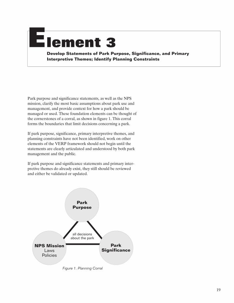
Park purpose and significance statements, as well as the NPS mission, clarify the most basic assumptions about park use and management, and provide context for how a park should be managed or used. These foundation elements can be thought of the cornerstones of a corral, as shown in figure 1. This corral forms the boundaries that limit decisions concerning a park.
If park purpose, significance, primary interpretive themes, and planning constraints have not been identified, work on other elements of the VERP framework should not begin until the statements are clearly articulated and understood by both park management and the public.
If park purpose and significance statements and primary inter
pretive themes do already exist, they still should be reviewed and either be validated or updated.
Park Purpose
NPS Mission Laws
Policies
Park Significance
all decisions about the park
Figure 1. Planning Corral
19
� �������� ��� �������� ��� ��������
Purpose, significance, and primary interpretive themes should not be identified early in the framework and later forgotten. Everything the planning team does in the VERP framework should be continually tested against park purpose, significance, and primary interpretive themes.
IDENTIFICATION OF PARK PURPOSE AND SIGNIFICANCE
The foundation of park planning, and the VERP framework, is formed by the purpose and significance of a park. In any plan
ning effort, the participants (including the planners, park staff, and the public) have assumptions, frequently not articulated, about the basic purpose and significance of a park. All planning discussions, proposals, and assessments, and all management decisions and actions will be filtered and evaluated by each indi
vidual based on his or her own set of assumptions. Until these assumptions are examined and understood by the participants, subsequent planning and management will lack focus and conti
nuity, and public understanding and consent will be difficult or impossible to achieve.
Park purpose is defined as the reason or reasons the area was set aside as a unit of the national park system. Park significance is summarized in statements that capture the essence of the park’s importance to our natural and/or cultural heritage — what is so important about this area that it belongs in the national park system? Significance statements place a park in a broader regional, national, or international context.
In addition to park purpose, all parks are subject to many legal and administrative mandates that apply to managing the national park system. Some special mandates also may apply to a particular park that are worthy of discussion and special con
sideration, either because they are unusual (such as a special provision for grazing in the establishing legislation of a park) or because they add another dimension to park purpose and sig
nificance (such as the designation of an area as part of the national wilderness preservation system, or a designation as a world heritage site or biosphere reserve). These special man-
dates may be documented in a park plan, but are listed sepa
rately from park purpose and significance.
20
Element 3
Pointers for Developing Park Purpose Statements
� Purpose statements articulate the reasons the park exists; they do not include mandates for management or other legis
lative requirements (see examples).
� Purpose statements must be grounded in park legislation, leg
islative history, and other formal designations (e.g., wilder
ness, biosphere reserve, or wild and scenic river status). Care should be taken in quoting legislation or legislative history verbatim as purpose or significance statements because the language is often vague and open to differing interpretation. Whenever possible, words contained in the legislation, such as “outstanding,” “natural,” “preserve,” and “enhance,” should be defined or qualified by the purpose statements (see exam
ples).
� As much as possible, purpose statements should be specific to the unit in question. If a purpose statement could be applied to any park in the system, it should be reexamined.
� Park purpose generally does not change. But in some cases they can evolve over time if conditions and values change and/or new information becomes available.
� As a general rule, parks should not have more than three to five purpose statements.
� All participants (planners, park staff, and the public) must understand and accept the park purpose statements. The statements are the result of extensive discussion and clarifica
tion. Draft statements should be developed by a small, facili
tated group, and then the statements should be evaluated and refined by larger groups and the public.
Examples of Park Purpose Statements
� To manage park scenery, natural and cultural resources, and wildlife in a manner consistent with the 1916 Organic Act.
This is not an effective purpose statement. It is merely a restatement of the NPS mission and policy. All this statement really says is that we are going to obey the law.
� To provide for livestock grazing, consistent with legislation and proclamations, while conserving and protecting resources.
21
� �������� ��� �������� ��� ��������
This is not an appropriate purpose statement. While provid
ing for livestock grazing is a legislative mandate for this par
ticular park, grazing is not the reason the park was established. This statement would be more appropriately documented as a special mandate.
� Preserve and protect special geologic features: labyrinths of remarkable canyons, volcanic phenomena, fossiliferous deposits, brilliantly colored strata, and rare sedimentation.
This is a much better purpose statement. It ties the purpose of this park to those essential features detailed in the enabling legislation.
� Preserve (for research) and interpret (for commemoration) sites and remains associated with the American Colonial period from 1607–1781.
Again, this statement is park-specific and begins to establish park priorities. The words “preserve” and “commemorate,” which appeared in the legislation, are better defined.
� Perpetuate, for future generations, a representative sample of the natural and cultural resources of the Big Dry Desert.
This statement gives some information about park priorities and also qualifies the word “preserve,” which was in the origi
nal legislation. At this park, the preservation of the entire Big Dry Desert would be impossible because of the small size of the park and increasing development outside the park bound
ary. So the staff used the language, “perpetuate . . . a repre
sentative sample,” as an achievable purpose.
Pointers for DevelopingPark Significance Statements
� Significance statements should define the overall significance of a park. Park significance is not an inventory of park resources or even “significant” park resources; a repetition of purpose statements; a statement of fact about or a description of a resource (without placing the statement in context); or a statement that a resource is significant (without explaining why it is important).
� A good test for significance statements is to ask, “If this resource or value were removed, would we still have XYZ National Park?” For example, Black Rocks National Monu
ment was set aside to preserve distinctive volcanic features.
22
Element 3
Nearby, and in park boundaries, is a section of trail ruts asso
ciated with the Irish migration to Mexico. If the volcanic rocks were gone, would we still have Black Rocks NM? If the answer is no, the volcanic rocks represent park significance. If the Irish trail were removed, would we still have Black Rocks NM? If the answer is yes, even though the trail resource may carry its own significance, and the park may have some man
agement and protection responsibility for it, the trail is not representative of park significance.
� Significance statements are intended to help set park priori
ties. The tendency to make significance statements inclusive enough to justify all ongoing park programs should be resisted. However, it should also be recognized that park staffs need to do many things that are not necessarily sup-
ported by their significance, but are dictated by laws or NPS policy. For example, a park whose significance is primarily archeological may need management programs in place to protect habitats for endangered species, even though the endangered species are not included in park significance statements.
� The argument may be made that all park resources are important, and therefore, it is not possible to determine sig
nificance or set priorities — all park resources are the highest priority. However, park managers need to know what is most important when making decisions on allocating limited money and staff time.
� Do not forget to consider park values from multiple cultural perspectives. For example, Native Americans may have differ
ent views on the significance of a park, which should be included in the list of significance statements.
� To find information about significance consult the park ena
bling legislation and associated history, documentation in support of special designations (such as a world heritage site or biosphere reserve), research reports, and experts.
� The number of significance statements will vary with each park unit. However, not even a park as large and diverse as Yellowstone National Park should have more than 10. Most parks will have three to five statements. If a significance state
ment can be applied to every unit in the system, it is not a good statement; significance statements are park-specific. (See the examples below for more tips.)
� As with purpose statements, all participants (planners, park staff, and the public) must understand and accept the park
23
� �������� ��� �������� ��� ��������
significance statements and must be involved in writing them and/or have input in refining them. The involvement of experts who know and understand park resources is crucial in developing accurate and useful significance statements. (Usu
ally park staff members are the experts, but there may be experts outside the staff who should be consulted.) On the other hand, significance statements that are written by only one or two experts may omit some statements or fail to describe park significance so it can be understood by park staff, planners, or the public. Draft significance statements should be developed by a small, facilitated group, and then the statements should be evaluated and refined by larger groups and the public.
Examples of Park Significance Statements
� The park and surrounding area provide a wide array of recrea
tional activities.
This is not a good significance statement. Can you think of a park about which this could not be said?
� The park contributes significantly to local economies in many ways.
While this may be a true statement, and may even represent park significance to a limited segment of the public, it does not represent the part of American heritage preserved at this park. Therefore, it is not a good significance statement. It would be an appropriate part of the description of the park and its relationship to the region in which it is located.
� The park and surrounding area provide a diversity of travel expe
riences, from paved and dirt roads, to trails, and unmarked backcountry routes.
This may be a valid “desired future,” but it is more an evalua
tion of the park infrastructure than a statement about the overall significance of the park.
� The park contains significant archeological and historical resources.
This statement is not useful because “significance” is not defined. Are they significant because they are rare, numer
ous, good examples of their type, the only ones in existence, or what?
24
Element 3
� The park contains one of the very few accessible examples of intertidal communities and chaparral communities representa
tive of the southern California coastal environment.
This significance statement is useful. It calls out special fea
tures (intertidal communities and chaparral communities), puts them in context (representative of the California coastal environment), and qualifies the significance (one of very few accessible examples).
Listed below are some more clear statements of park signifi
cance. They explain the nature of the significance and put the area in context:
• The most pristine and biologically diverse area of the Big Dry Desert occurring in the United States.
• The climactic campaign of the Revolutionary War — the symbolic end of British colonization.
• The park contains one of the last free-flowing river systems contributing to major canyon formation on the Colorado Plateau.
IDENTIFICATION OFPRIMARY INTERPRETIVE THEMES
Primary interpretive themes are those ideas about park resources that are so important that every park visitor should understand them. The list of primary themes does not include everything a park staff may wish or need to interpret, but should cover those ideas that are critical to visitor understanding of park significance.
There is not complete agreement among planners on the need to include primary interpretive themes as a part of the planning foundation. Those who do not believe that primary themes should be included argue that identifying themes places more emphasis on the interpretation program than other park pro-
grams. Those who support identifying primary themes argue that, just as significance statements begin to set resource protec
tion priorities, the primary interpretive themes flow out of park significance and help set visitor experience priorities. In other words, the primary interpretive themes help define the visitor experience opportunities that should be provided in a park.
25
� �������� ��� �������� ��� ��������
A new trend in some parks is to articulate “park themes” that are broader than interpretive themes and can be thought of as themes for resource management and maintenance as well as for the interpretation program. Examples of both kinds of themes are offered below.
Pointers for Articulating Primary Interpretive Themes
� Primary themes are only those basic ideas that communicate the significance of the park. This is not an outline of the entire park interpretation program. Do not list all of park interpretive themes and call them primary themes.
� To be most useful, themes should be written as complete sen
tences to communicate a complete thought. Incomplete thoughts do not provide enough focus to be useful in guiding planning and management efforts. For example, rather than writing, “the importance of Spanish and Portuguese explora
tion” (a topic, not a complete thought), write “Spain and Por
tugal played major roles in human understanding of the globe — they explored three-quarters of the U.S. and colonized half of it” (a complete thought, and the actual message to be con
veyed).
� The list of primary interpretive themes is short. Most parks should not have more than three to five primary interpretive themes. Keep in mind that some significance does not need to be interpreted, only experienced. For example, many parks include unusual or particularly spectacular scenic vistas as part of their significance; such vistas rarely require interpretation.
Examples of Primary Interpretive Themes and Park Themes
The following primary interpretive themes were developed for the Blue Ridge Parkway:
• The Blue Ridge region is among the biologically richest ar
eas in North America.
• Material cultures and life ways in the Blue Ridge province illustrate how isolation and assimilation shape cultures.
26

Element 3
• The parkway is a special roadway and a managed land
scape that was designed to maximize scenic values.
A different approach to developing primary interpretive themes was taken at John Day Fossil Beds National Monument:
• At John Day Fossil Beds National Monument
there are lots of fossils
there is a great diversity of fossils
the fossils are very well preserved
the fossils represent an unusually long time span
the fossils are datable
Thus, it is wonderful place to study evolutionary change.
At Isle Royale National Park the park staff identified “park themes” instead of primary interpretive themes. These themes incorporate key resources and stories that characterize the park. Some examples of these park themes include:
• Self-sufficiency is a way of life on Isle Royale. Self-
sufficiency is as important today for park backpackers, ca
noeists, and boaters as it was for those who first used and settled the island — Native Americans, European miners, lighthouse keepers, and commercial fishermen.
• Isle Royale is a living laboratory where plant and animal life can be studied in a relatively simple and controlled ecosys
tem. The theory of island biogeography is illustrated by both the limited number and variety of species found here.
• Because of Isle Royale’s generally undisturbed setting, it is an important source of information about the world around us — how the world evolved, how the impacts of civilization have altered natural systems, and what the unmodified envi
ronment holds.
• The Park Service is striving to sustain the native fishery of Isle Royale National Park — perhaps the most exceptional fishery in the Great Lakes region. For centuries Isle Royale’s waters have attracted fishermen — prehistoric people, immi
grant commercial fishermen, and today’s sport fishermen. A relic of the past, adaptive fishing lifestyle and technology still remains and reminds us of this significant island culture.
27
� �������� ��� �������� ��� ��������
IDENTIFICATION OF PLANNING CONSTRAINTS
Planning constraints are those decisions that are “givens” and usually are not reconsidered during the planning effort. Exam
ples include decisions that are contained in recently approved plans, the conditions of current concession contracts, under-
standings or agreements made between the park and another agency, tribal government, or members of the public, past prom
ises, and political commitments.
Many planning participants will have their own ideas about what can and cannot be considered in a planning process. Waiting too long to clarify these assumptions will create problems and con-
fusion later on. Sometimes the public will have strong feelings about issues that will not be addressed in a particular plan. Early identification of what will and will not be addressed in the planning effort is important in focusing attention on appropriate issues and not raising expectations on issues that are outside the scope of the VERP framework.
Pointers for Identifying Planning Constraints
� There must be justification for planning constraints. The opinions and personal agendas of planners or managers or “we have always done it this way” are not sufficient justifications.
� Other governmental agency mandates may affect a park, and therefore, should not be forgotten. For example, the man-
dates of an adjacent national forest may constrain how park management zones are applied in certain areas.
� Good sources of information on planning constraints include park and other office files, staff with institutional memory (e.g., long term park employees), and superintendents (who may be a good source for political and other types of real and perceived constraints).
� Planners and park staffs frequently assume that constraints exist when in fact they are not real. Constraints also may be assumed to be non-negotiable when that is not the case. Thus, there is a need to question and validate planning constraints before accepting them. This is particularly true for constraints seen as park or local traditions. Discussion of what actions must be done (“must do’s”) and what actions are not possible (“can’t do’s”) often broaden the flexibility and scope of the plan, rather than narrowing the plan.
28
Element 3
� Planning constraints should be identified, documented, and shared with the public as early in the planning process as pos
sible. All participants must understand these constraints.
� Constraints may need to be reexamined throughout a plan
ning effort to ensure they are still valid. Information gener
ated as a result of planning may alter thinking on some constraints.
Examples of Planning Constraints
• The National Park Service will not ban motor boats, sport fishing, or docking facilities in the park (political con
straint, past promise).
• Fishing in the park will be managed in cooperation with the state (past formal agreement).
• The National Park Service will minimize the loss or degradation of wetlands in the park (executive order).
• There will be no additional land acquisition in the park boundaries (political constraint, past promise).
• The National Park Service will keep open the XXX Campground regardless of money and staff limitations (political commitment).
• The National Park Service will abide by the policies of the interagency management commission (formal agree
ment).
29
Element 4 Analyze Park Resources and the Existing Visitor Use
Element 4 is intended to provide the planning team with a common understanding of park resources and visitor experi
ences.The term “resource” is defined here as the biotic, geo
logic, hydrologic, aesthetic, ethnographic, architectural, historic, and archaeological elements and features contained in a park. The mix of these resources helps shape visitor experiences in a park. The team analyzes resources and visitor experience in order to
• categorize important information and give the planning team a common vocabulary
• understand what experience opportunities, based upon park resources, could be provided to visitors in the con
straints of resource protection
• document existing conditions and uses in the park
It is important to remember that this element describes existing conditions; it does not prescribe future conditions.
ANALYSIS AS IT RELATES TO VERP
Using analysis techniques to provide a working understanding of resources and existing conditions is common to all planning efforts. There are several aspects of the VERP framework, how-
ever, that require some changes in the way NPS planners tradi
tionally have carried out analysis activities for planning.
• Need to Document the Analysis. In the past much analysis was carried out more or less intuitively and through dis
cussion among the planning team members. Because of the need to document the decision-making thought pro
cess throughout the VERP framework, the team’s
30
Element 4
analysis, and the conclusions the team draws from it must be documented.
• Need to Understand Resources from an Experiential View-
point. The opportunities for diverse visitor experiences in a particular park are largely determined by resource characteristics such as variety, attractiveness and accessi
bility to visitors, and the relationship of various resources to park purpose and significance. Planners and managers need to understand these resource characteristics in or
der to define and manage for a range of visitor experi
ences that is appropriate to that park.
• Need to Understand the Ability of the Resource to With-
stand/Tolerate Use. Providing opportunities for visitors to experience resources must be undertaken in the context of resource protection and preservation. Different re-
sources have different abilities to accommodate various visitor activities. Identifying the most sensitive resources or resource areas is an initial step in ensuring the provi
sion of appropriate types and levels of visitor use.
• Need to Test or Question the Appropriateness and Current Location of Existing Facilities and Infrastructure. In the past the Park Service’s usual response to increasing pres
sure from visitor use has been to harden sites and/or to increase the capacity of facilities and infrastructure (such as roads and utility systems). The VERP framework of
fers additional solutions based on the desirability of expe
riences that may require fewer facilities, smaller facilities, or facilities in different locations than currently are provided.
Analysis results are used throughout the VERP planning ele
ments to
• help define the potential range of management zones that may be appropriate in a particular park
• help determine where particular management zones might be placed in a park (for example, higher use zones should be allocated to more resilient resource areas)
• justify why certain zones are allocated (or not allocated) to certain locations; as baseline data against which to evaluate the implications of zoning areas one way versus another (impact analysis)
31
� �������� ��� �������� ��� ��������
• help park managers make management decisions long af
ter a particular plan is completed.
Analysis is a creative process — there is no one right way to accomplish it, so long as the needed outcomes are produced. In this section of the handbook, we discuss three kinds of analysis, all of which are recommended for a VERP project. While exam
ples are presented, planners should keep in mind that these examples are not necessarily the only methods that could be employed. Analysis methods must be tailored to the needs of each individual situation, the availability of data and technology in each particular park, and the capabilities and experience of the planning team.
Pointers for Analysis
� While there are different approaches that can be followed in this element, whatever approach is used must be documented. This will help keep track of important decisions made along the way, and it will be easier for the planning team to make adjustments and correct errors.
� It is important to think about what information is really needed for the plan. On the one hand, there is more park resource information, and it is more accessible than ever bef
ore. On the other hand, the team will probably find that it does not have all the resource information it would like. The inventory of resources and existing conditions should be tai
lored to park significance, the goals and problems being addressed in the plan, and the level of detail needed. Taking the time to define needed baseline information will help ensure that the team gets the appropriate information and avoids wasting time and dollars collecting unnecessary data. Keep in mind that it is better to take action to protect the resources the team knows about than to do nothing because the team does not have as complete information as it would like.
� To understand a park, it is necessary to understand the con-
text or environment in which the park is located. Lands adja
cent to a park may affect the condition or sensitivity of park resources, visitor experiences, and the need to provide various opportunities in a park.
� There is a full range of graphic and text options that provide flexibility in displaying analysis information. A combination of text, matrices, and maps is common. Data layer overlays may
32
Element 4
be digitized and used as a part of a geographic information system (GIS), or they may be hand drawn on polyester film (e.g., Mylar) for manual overlaying of one sheet over another. The decision to use GIS or hand-drawn maps is dependent upon the complexity of data, the time frame for completing the VERP work, the project budget, the availability of digit
ized data, and the staff expertise to do the specialized com
puter work.
� Resource analysis is usually best performed by experts (some of whom may not be on the planning team or park staff) who know the resources and have the knowledge or the under-
standing to carry out accurate evaluations. The planning team may also want others, including visitors, stakeholders, and citizens, to review the results of this analysis, because they often can provide valuable insights and observations.
EXPERIENTIAL RESOURCE ANALYSIS
The purpose of this kind of analysis is to help the planning team understand the park as a system of physically definable and experientially different spaces. A park landscape can be thought of as having a “floor plan” with a collection of individual rooms or “landscape units” that can be entered and experienced, like the rooms of a building. The intent of this task is to define the park floor plan by identifying and mapping all of the individual units that comprise the floor plan. In natural parks, topography, hydrology, and vegetation will primarily define the park land
scape units; in cultural resource parks, architectural elements and structures and landscape plantings also may define units.
To accomplish this analysis, various data layers are combined and analyzed to define a set of polygons that segment the entire park into units or rooms. The polygons are based on the edges or boundaries enclosing spaces with relatively homogeneous vegetation, the characteristics of the surrounding landform and waterform, or, in the case of a cultural area, the architectural style or function of a particular space. Identifying landscape units involves locating and mapping such elements as prominent ridge lines, steep topographic slopes, forest edges, grouped forms which dominate an area, architectural walls, buildings, landscape plantings, junctions between land use areas, and land cover patterns.
Once landscape units are defined, the experiential qualities of each unit can be described. These descriptions might contain information on colors, textures, spatial enclosure, vegetative cover, and other natural or cultural resources contained in the
33
� �������� ��� �������� ��� ��������
unit. Characterizing the experiential qualities of the landscape units may show that some units provide very similar kinds of experience opportunities. To carry the “room” analogy further, a house may have ten rooms: five bedrooms, three bathrooms, a kitchen, and a living room. Similarly, landscape units that share experience characteristics may be grouped into opportunity areas. For example, a park may have nine landscape units defined by topography and vegetation, but because three of the units are very similar to each other, the park would have only seven opportunity areas. If all nine landscape units were experi
entially distinct, the landscape units and opportunity areas would be the same.
How opportunity areas are mapped may differ for each park, but the delineation of the opportunity areas should be deter-
mined by the resources. Opportunity areas should not be defined by or be limited to existing park visitation patterns, the established visitation uses, or the existing infrastructure (e.g., roads, trails, visitor centers, comfort stations, overlooks). Stating this another way, planning teams should map opportunity areas (i.e., develop a park floor plan) only based on resource-related overlays. This allows the resources, the locations of attractions, and the kinds of experience opportunities to direct the need for and the location of park infrastructure, rather than the reverse.
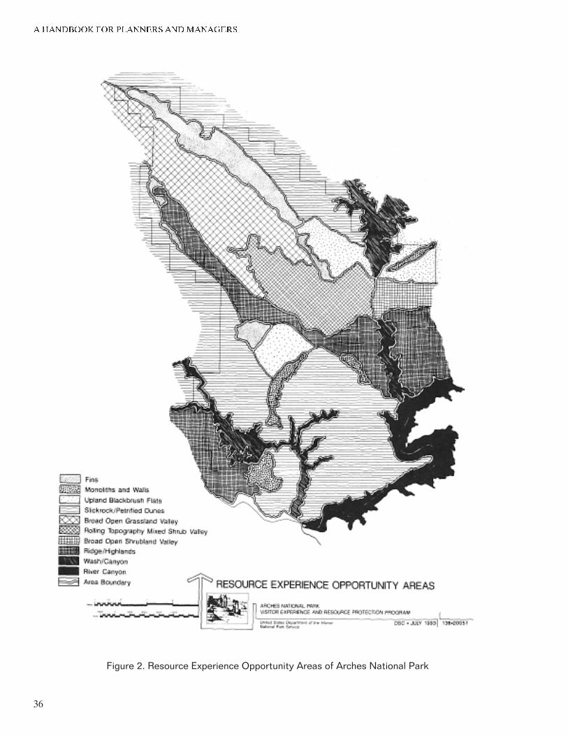
Two examples of opportunity areas that were developed for the Arches VERP plan are the fins and upland blackbrush flat.
• Fins. This opportunity area includes the Devils Garden, Fiery Furnace, Klondike Bluffs, and Herdina Park areas. They are dominated by the orange-to-reddish Entrada sandstone fins and spires. In these areas there are laby
rinths of spires, fins, chutes, and arches. The visitor expe
rience in this opportunity area is very much inwardly focused because of the high vertical landforms that limit movement and views along narrow corridors. The imme
diate foreground and the focused corridor views of land-
forms dominate the experience; in contrast, the importance of color and vegetation cover is minimal.
• Upland Blackbrush Flats. This opportunity area covers most of Willow Flats. These areas are generally flat, with some relief, and appear sandy or rocky. They have few distinguishable geologic features. Low, dark, blackbrush dominates the landscape. The vegetation can appear to be an obstacle, and there are no obvious routes through the areas.
34
Element 4
Figure 2 shows all of the opportunity areas that were identified at Arches. (All of the Arches opportunity areas are described in appendix A.)
For each of the opportunity areas, the Arches team evaluated several attributes to determine which could support or sustain visitor use, as well as the relative abundance of various resources and the comparative importance of each area to the park purpose, significance, and primary interpretive themes. This analysis helped to compare the human values inherent in each of the opportunity areas and highlighted areas where resource sensitivity may be in conflict with desired visitor. It also assisted in determining the potential range of visitor experiences and management zones for the park.
Table 1 shows the analysis that was developed for Arches. As shown in the table, six specific attributes were analyzed for each opportunity area. These include the
• relative abundance of the resource area, both in and out-
side the park
• ability of the resource area to conceal the evidence of visitor use or development
• ability of the resource area to support or sustain visitor use
• potential interest of the resource to visitors
• relative importance of the area to the park purpose, sig
nificance, and primary interpretive themes
• sites or features in the resource area that are of critical importance to park purpose, significance, and interpre
tive themes
35
� �������� ��� �������� ��� ��������
Figure 2. Resource Experience Opportunity Areas of Arches National Park
36
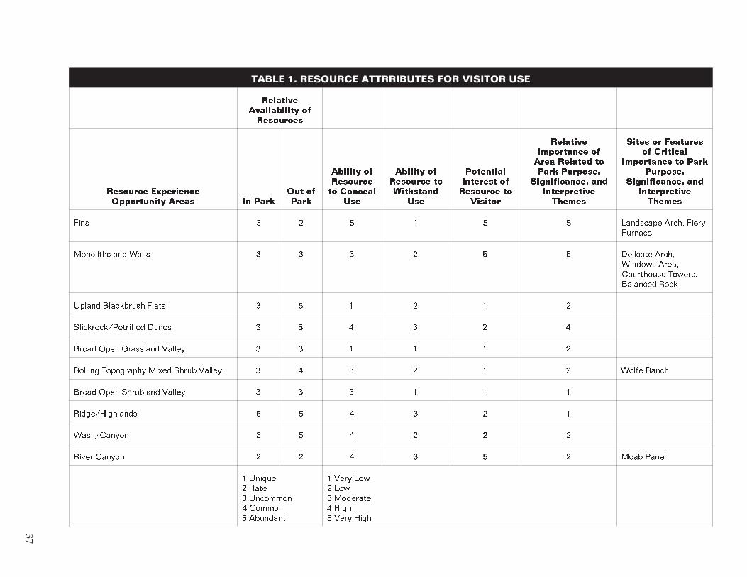
TABLE 1. RESOURCE ATTRRIBUTES FOR VISITOR USE
�������� ������������ �� ���������
�������� ���������� ����������� ����� �� ����
��� �� ����
������� �� �������� �� �������
���
������� �� �������� �� ���������
���
��������� �������� �� �������� ��
�������
�������� ���������� �� ���� ������� �� ���� ��������
������������� ��� ������������ ������
����� �� �������� �� ��������
���������� �� ���� ��������
������������� ��� ������������ ������
���� � � � � � � ��������� ����� ����� �������
��������� ��� ����� � � � � � � �������� ����� ������� ����� ���������� ������� �������� ����
������ ���������� ����� � � � � � �
������������������� ����� � � � � � �
����� ���� ��������� ������ � � � � � �
������� ���������� ����� ����� ������ � � � � � � ����� �����
����� ���� ��������� ������ � � � � � �
��������������� � � � � � �
����������� � � � � � �
����� ������ � � � � � � ���� �����
� ������ � ���� � �������� � ������ � ��������
� ���� ��� � ��� � �������� � ���� � ���� ����
37
� �������� ��� �������� ��� ��������
Pointers for Experiential Resource Analysis
� The planning team may need to prepare several maps as well as text and matrices to identify the landscape units and oppor
tunity areas. For example, at Arches, edges were coarsely identified on a map titled, “Landscape Framework.” Then, the landscape units were established by drawing lines which follow the natural boundaries and edges defined during the landscape framework analysis. Landscape units were com
pared to see which units shared similar experience opportuni
ties. These similar units were grouped, coded on a map, and named to reflect the resource experience available there. To differentiate the experience groups from landscape units, the groups were termed resource experience opportunity areas. The characteristics and patterns of each group of areas were described and documented in writing and on a matrix. This documentation allowed the introduction of information that was difficult or impossible to map.
� Landscape units and opportunity areas are descriptive analy
sis tools, not prescriptive zoning tools. While the resource characteristics in an opportunity area will help planners decide what management zones might be appropriate or inap
propriate in a particular area, the opportunity area bounda
ries should not be used to determine management zoning boundaries. Some management zone boundaries may turn out to be the same or similar to opportunity area boundaries, but this should occur by coincidence, not by design.
� It is very important to understand how resources shape the visitor experience, independent of park infrastructure. Keep resource information separate from the inventories of park facilities and visitor use (see next section).
EXISTING USE AND FACILITIES ANALYSIS
The purpose of this analysis is to understand the existing visitor experience opportunities offered in the park by documenting what people are doing, where they are doing it, how many peo
ple are using various park areas, and what facilities and infra
structure are currently present in the park. Analysis can help us understand some of the reasons people go where they go and do what they do in the park, including the identification of key attractions sites, activity areas, and “hot” spots.
38
Element 4
Information the team may need for this analysis includes the
• location of park facilities (e.g., roads, parking areas, trails, buildings, utility corridors)
• differences in standards and/or functions of the facilities (e.g., paved, unpaved, gravel-surfaced roads; surfaced, unsurfaced trails and boardwalks; visitor centers, admini
stration buildings, restrooms)
• types of activities (e.g., hiking, crosscountry skiing, scenic views)
• the circulation of visitor traffic and the sequence in which opportunity areas are visited
• levels, timing, and seasonality of visitor use
• activity nodes
• areas with special use designations (e.g., wilderness areas, wild and scenic rivers, historic districts)
• development and land use practices external to the park (e.g., roads and trails, land ownership, existing activities, land use zoning)
• key attractions in the region, especially those typically in
cluded in park visitor itineraries
Pointer for Existing Use and Facilities Analysis
� One of the most common areas of information lacking in parks is how many people are where at any one time. Ideally, this information should be collected prior to beginning a VERP effort; however, if this does not occur, planners will need to rely heavily on park staff knowledge to obtain this information. This kind of data can be obtained by researchers especially for a VERP effort, but gathering visitor use data across large park areas will be costly and time consuming.
39
� �������� ��� �������� ��� ��������
RESOURCE CONCERNS / RESOURCE SENSITIVITY ANALYSIS
The purposes of this analysis are to identify the primary resource concerns and resources that are sensitive to human use or environmental change. Identifying resource concerns and sensitive resources helps the planning team define potential management zones and apply the zones to the park in a manner that minimizes conflict between visitor use and resource protection.
Resource concerns or threats are often described in text. For example, a concern in some areas is that the populations of cer
tain bird species are declining because they can no longer find enough large, uninterrupted tracts of forest in which to breed. A short paragraph could provide enough information to help a planning team site development and transportation corridors so that forests are not further fragmented, or so that forest frag
ments are reconnected. Schematic maps (with notes, symbols, and arrows) can also be used to illustrate resource threats.
The product of resource sensitivity analysis is typically one or more maps showing the relative resource sensitivity of different areas to human activity or environmental change (e.g., habitat alteration or facility development). Individual sensitive resources are first mapped at relatively coarse scale, either by hand or in a GIS format. Then the individual maps are overlaid (again by hand or digitally) to create a “synthesis map” showing the spatial distribution of all of the sensitive resources and their locations relative to other park features, such as infrastructure. The overlay method also identifies places where more than one sensitive resource occurs in the same area. In some cases, before overlaying the resource layers, the planning team assigns a higher weight (or value) to certain resources known to be more sensitive or vulnerable to impacts. On the resulting synthesis map, highly sensitive areas represent either particularly sensitive individual resources or areas where two or more sensitive resources co-occur.
The type of sensitive resources identified and mapped may vary with the size and character of the park and with the nature of available information. Examples include
• archeological resources
• wetland areas
• floodplain areas
• erosive soil and steep slopes
40
Element 4
• threatened and endangered species and their habitat
• rare or special plant communities or associations (e.g., dunes, bogs, tundra)
• corridors for animal movement (often drainages or stream courses)
• wildlife winter range
• critical nesting, mating, or breeding areas
• historical sites and structures
• historic districts
Pointers for Resource Concerns / Resource Sensitivity Analysis
� When planning teams use synthesis maps, questions often arise regarding specific resources in certain areas. Therefore, it is usually helpful for the team to have individual resource maps (as well as synthesis maps) available for reference.
� The team should understand the nature of the ecosystem characteristics, such as succession, nutrient cycling, energy flow, and disturbance regimes. The team should also consult with experts as needed. Understanding the ecosystem struc
ture and function will help identify resource threats, as well as components and relationships that must be preserved to ensure ecosystem health. In the Arches case, for example, insights into the importance of the cryptobiotic soil crust (a living soil consisting of cynobacteria, lichens, and mosses) led the planning team to use soil crust as an indicator of ecosys
tem integrity.
41
Element 5 Describe a Potential Range of Visitor Experiences and Resource Conditions (Potential Management Zones)
In element five, the focus moves from being descriptive to being prescriptive. In this element the team begins to formulate and describe future conditions for a park. Element five focuses on determining what resource and managerial conditions and visi
tor experience opportunities should exist in a park.
IMPORTANCE OF DIVERSITY
Providing opportunities for a range of visitor experiences is an important part of planning for most national parks. One might ask, “why should a park provide opportunities for more than one type of experience?” Visitors come to national parks for very different and sometimes conflicting reasons. By providing a diversity of settings, visitors can theoretically select which experience(s) most closely match the reason that they came to the park. Also, planning for a diversity of experiences helps to avoid the conflicts that often occur among visitors who want dif
ferent things from their visits.
National parks normally provide opportunities for a diversity of experiences by providing a variety of settings or environments for visitors. For example, in Yosemite National Park, a visitor can experience a largely urban environment (Yosemite Valley) and also experience wilderness in the high Sierras. In Yosemite, as in other national parks, many other identifiable settings are between these two extremes.
In the past park managers and planners did not try to define the types of visitor experience opportunities different areas in a park could best provide. It also was not recognized that changes in the levels of visitor use and in behavior, as well as visitor impacts and management reactions to those impacts, affect the diversity of visitor experiences in the parks. Most visitors went to areas in the parks with special attractions (e.g., Old Faithful
42
Element 5
Geyser, Yosemite Valley) and/or to easily accessible areas. Park managers and planners largely responded to increasing visitor use levels with what were believed to be appropriate infrastruc
ture and management policies. For instance, sites often were altered to accommodate more visitor use. But, the increased lev
els of use and reactive management action frequently changed the characteristics of the settings and the visitor experience.
The VERP framework takes a different approach from what was done in the past. The framework is prescriptive and proac
tive about
• what visitor experience opportunities are provided in a park
• what the essential elements of those experiences are, how much land should be allocated to various visitor experi
ence opportunities
• where in the park should the opportunities be provided.
The VERP framework also is intended to ensure that a diversity of experiences is available in a park. It is not intended to ensure that a diversity of experiences will be available at every attrac
tion in the park, nor is it intended to protect all experiences in all zones. It may not be possible to provide opportunities for a diversity of experiences at unique attractions, such as at Old Faithful Geyser.
IDENTIFYING THE RANGE OF POTENTIAL RESOURCE CONDITIONS AND VISITOR EXPERIENCES
The objective of element five is to determine the range of potential visitor experiences and resource conditions that can be accommodated in a park. This is done by creating a series of potential management zones. Each potential zone is defined by the
• resource conditions
• social conditions
• kinds and levels of visitor uses
• kinds and levels of park development
• kinds and levels of management activity
43
� �������� ��� �������� ��� ��������
Both matrices and written narratives are developed to describe the potential zones. It is usually best to start out developing a matrix similar to table 2. The matrix consists of two axes. One axis lists the potential zones, while the other axis consists of key factors, or descriptors, that describe the potential quality of the zones and differentiate one potential zone from another.
The potential zone names are relatively unimportant but should be derived from the visitor experience opportunities or resources in the zone instead of the infrastructure in the zone. For example, rural (an experience opportunity) is a better name than unpaved road (an infrastructure feature).
The descriptors usually can be separated into three main categories.
• Social Descriptors. Those aspects about the experience that are related to the effect of visitors on other visitors (e.g., visitor behavior, numbers).
• Resource Descriptors. The biological, geological, cul
tural, or scenic aspects related to the experience.
• Managerial Descriptors. Those aspects of the visitor ex
perience that are controlled by management (e.g., infra
structure, the presence of park staff, the intensity of management, and signing). Once the matrix is filled in, written descriptions of each of the potential zones should be completed. These narratives expand on the matrix, providing a more holistic perspective on the zones and their characteristics.
After the descriptors are chosen, the matrix is filled in by the planning team. The objective here is to seek a consensus on what the potential zones are and how they qualitatively differ from other zones — it is not necessary to be definitive and quantitative at this point. Words qualifying the descriptors may include: “large,” “small,” “moderate,” “high,” “low,” “extreme,” “minuscule,” “not applicable,” “medium,” and “variable.”
Developing the potential zones may take several days. Substan
tial revisions may be required as the team begins to relate the potential zones to specific geographical areas (see element 6). New descriptors often are added; others may be deleted. Poten
tial zones may be combined when there appear to be little dif
ference between them. Other potential zones may be added if the team subsequently identifies omissions in the range of desired visitor experiences and resource conditions.
44
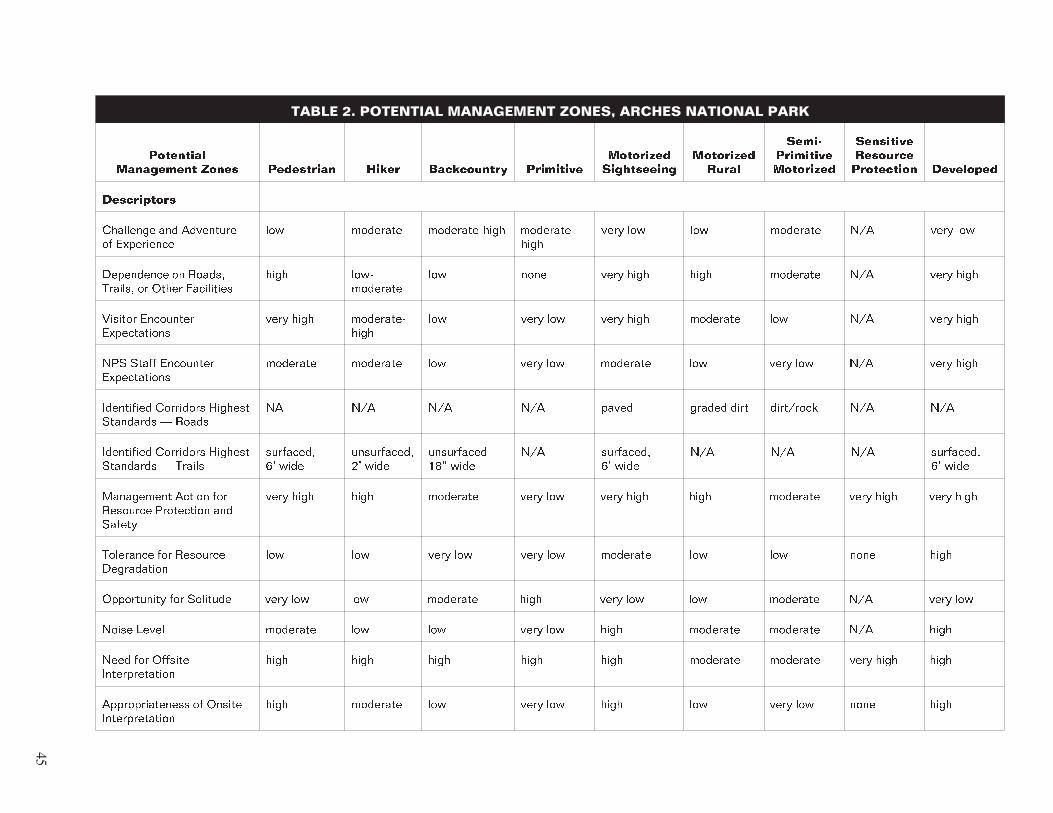
TABLE 2. POTENTIAL MANAGEMENT ZONES, ARCHES NATIONAL PARK
��������� ���������� ����� ���������� ����� ����������� ���������
��������� �����������
��������� �����
����� ��������� ���������
��������� �������� ���������� ���������
�����������
��������� ��� ��������� �� ����������
��� �������� ������������� ��������� ����
���� ��� ��� �������� ��� ���� ���
���������� �� ������ ������� �� ����� ����������
���� ���� ��������
��� ���� ���� ���� ���� �������� ��� ���� ����
������� ��������� ������������
���� ���� ��������� ����
��� ���� ��� ���� ���� �������� ��� ��� ���� ����
��� ����� ��������� ������������
�������� �������� ��� ���� ��� �������� ��� ���� ��� ��� ���� ����
���������� ��������� ������� ��������� � �����
�� ��� ��� ��� ����� ������ ���� ��������� ��� ���
���������� ��������� ������� ��������� � ������
��������� �� ����
����������� �� ����
���������� ��� ����
��� ��������� �� ����
��� ��� ��� ��������� �� ����
���������� ������ ��� �������� ���������� ��� ������
���� ���� ���� �������� ���� ��� ���� ���� ���� �������� ���� ���� ���� ����
��������� ��� �������� �����������
��� ��� ���� ��� ���� ��� �������� ��� ��� ���� ����
����������� ��� �������� ���� ��� ��� �������� ���� ���� ��� ��� �������� ��� ���� ���
����� ����� �������� ��� ��� ���� ��� ���� �������� �������� ��� ����
���� ��� ������� ��������������
���� ���� ���� ���� ���� �������� �������� ���� ���� ����
��������������� �� ������ ��������������
���� �������� ��� ���� ��� ���� ��� ���� ��� ���� ����
45
� �������� ��� �������� ��� ��������
Examples of potential zones are described below. The first two descriptions are from the Arches VERP implementation plan. The third is from the Isle Royale National Park General Man
agement Plan and is included to show some of the variety of zones and the ways they may be described. (A description of all the zones from the Arches plan is included in appendix B.)
Example of Zone Descriptions from Arches National Park
Pedestrian Zone. This zone is comprised of high use trail corri
dors that access prime park features. The areas in this zone are predominately natural, but with much evidence of the sights and sounds of people. Visitors can see, touch, smell, and hear park resources as they walk along a well-defined trail, but they will not feel like they are far from their cars or conveniences. Paved or hardened trails and small interpretive structures are the only facilities present. Some trails would be accessible to visitors with disabilities. To use this area, visitors must make a short time commitment and physically exert themselves to some degree. There are limited opportunities for challenge and adventure, and the need for outdoor skills is relatively unimportant. The probability of encountering visitors is very high and moderate for encountering NPS staff; many people may be present. No vehicles or stock are permitted in this zone.
Visitors, sites, and trails are intensively managed in the pedes
trian zone to ensure resource protection and public safety (e.g., with fences, intensive law enforcement, and restrictions on visi
tor activities). Resources can be modified for essential visitor and park operation needs, but they are changed in a way that harmonizes with the natural environment. Except for these essential changes, the Park Service's tolerance for resource degradation here is low.
Hiker Zone. This zone is applied to trail corridors and areas of a somewhat more primitive nature than those in the pedestrian zone. The hiker zone provides a sense of being immersed in a natural landscape and feels somewhat distant from most com
forts and conveniences. Unpaved, maintained trails, and some-
times cairned routes are the only facilities in this zone. Opportunities exist to experience challenge and adventure. Visi
tors must commit a block of time, have some outdoor skills, and expend some physical exertion to use the area. The probability of encountering other visitors is moderate to high (although there are opportunities for solitary experiences) and moderate
46
Element 5
for encountering NPS staff. No vehicles or stock are permitted here.
A high level of management is provided for resource protection and safety purposes in the hiker zone (e.g., placing stones along trail edges and restricting off-trail use and group sizes). Some resource modifications are evident, but they harmonize with the natural environment. Park Service tolerance for resource degradation here is low.
Example of Zone Description from Isle Royale National Park — Motorized Sensitive Waters Zone
Visitor Experience. This would be a zone where motorboat-borne visitors and others could go to find relatively tranquil, natural marine surroundings. The probability of encountering other visitors would be moderate, but solitude would be possible. Tol
erance for noise, visual intrusions, and social interaction would be moderate. Any challenge or adventure would probably relate to navigation in difficult climatic conditions. Visitors would need to be relatively self-sufficient.
Resource Condition or Character. This zone could be in sheltered Lake Superior harbors and bays where calm waters and rela
tively quiet are desirable for safety, resource, or visitor experi
ence reasons. It might be appropriate, for example, in harbors or bays where water birds nest or where facilities such as visitor centers or campgrounds are located. A moderate level of man
agement would be provided for resource protection and visitor safety. The tolerance for resource degradation in this zone would be low.
Appropriate Kinds of Activities or Facilities. Human-powered and motor-powered watercraft could be found in these waters. Boats would travel at slow speeds and leave no wake. Boat anchorages would be appropriate here.
47
� �������� ��� �������� ��� ��������
POINTERS FOR DETERMINING THE RANGE OF RESOURCE CONDITIONS AND VISITOR EXPERIENCES
� Potential management zones describe the conditions to be created, sustained, or tolerated, not the actions necessary to create the conditions. In other words, the zones describe “what” the team is trying to create, not “how” to create those conditions.
� Usually there are neither definitive data to guide the team in determining the range of resource conditions and visitor experiences nor checkpoints to ensure that the team is on track. Developing this element requires much brain storming, discussion, and open-mindedness on the part of the team. It is greatly aided by a facilitator and by individuals intimately familiar with park resources and visitors.
� Because the determination of what a park should or should not provide is largely subjective and often value laden, a full understanding of public values and expectations is required. The development of potential management zones is generally done by the team and reviewed and refined by larger groups and the public.
� Some guidance for determining the range of potential zones appropriate to a particular park is provided by the
• regional context of the park
• park purpose, significance, and primary interpretive themes (defined in element 3)
• distribution and abundance of different park resources mapped in element 4 (e.g., vegetation, terrain, or sensitive wildlife might give clues as to what experience opportunities might be provided as well as what should not be provided)
� Understanding visitor wants and needs can help determine a range of desirable visitor experiences and resource condi
tions. This information can be obtained through a visitor sur
vey or a newsletter with an accompanying response form. Alternatively, the information may be collected using focus groups or by holding conversations with visitors. At the very least, individuals who interact with park visitors on a daily basis should be involved in developing this element. In most parks, these individuals are the interpreters, information desk personnel, maintenance personnel, and other providers of visitor information. They may be permanent or seasonal park
48
Element 5
employees, volunteers, or interpretative association employ
ees. Because these individuals listen to and answer visitor questions daily, it places them in a position to provide good information and thoughts to the planning team.
� Inventorying the surrounding region will help determine what types of visitor experience opportunities might best be pro
vided outside the park and the types of opportunities that can occur only in it. Providing a range of recreational opportuni
ties in a region is desirable to satisfy the diversity of recrea
tion tastes. No one park manager or agency should feel obligated to meet the demands of all recreational users. Each agency, for example, could aim at providing one or more spe
cific types of recreational opportunities and refer those want
ing something different elsewhere. Obviously, regional collaboration among private and public managers is manda
tory if a full and appropriate mix of opportunities and bene
fits is to be provided.
� A risk in element 5 is that the team will only look at the exist
ing visitor experiences, recreational activities, resource condi
tions, and managerial conditions and describe them. This may be appropriate; however, potential opportunities may be missed if the team is narrowly focused on what is, rather than what could be, or if the team hurries through this element. Going back to the experiential resource analysis work may be useful in checking to see if potential experience opportunities have been missed.
� In describing a potential zone, a team is often tempted to use words that actually describe an activity rather than an experi
ence. This should be avoided — it is the experience on which the team should be concentrating. For example, a team might create different potential zones for hiking, equestrian use, and overnight camping. These are all activities, not experi
ences. The potential zone instead should focus on the intended experience (e.g., giving visitors an opportunity a sense of being in wildlands, with opportunities for challenge and adventure). Depending on the desired experience, it is possible that one potential zone might provide opportunities for all of the above activities.
� The goal of management zoning is to identify areas with dif
ferent management requirements. Some variations of visitor experiences and resource settings, and many different visitor activities may occur in a single zone so long as the manage
ment prescriptions remain constant. Sometimes there is a ten
dency for team members to be either lumpers or splitters in developing potential zones. Splitters can bog down the
49

� �������� ��� �������� ��� ��������
process by trying to define different management zones for every different experience or setting. Lumpers can make the zones useless by including areas in the same zone that must be managed differently. A middle ground must be sought that defines enough zones to clarify management requirements without over complicating the zoning scheme.
50
Element 6 Allocate the Potential Zones to Specific Locations in the Park (Prescriptive Management Zoning)
In element 6, the potential management zones described in ele
ment 5 are allocated to specific geographic areas. This process of management zoning is a key planning tool for making deci
sions about what is appropriate and not appropriate in a park, and what can and cannot occur in different areas of the park in terms of resources management, visitor use, and development.
There is no set way, no standardized approach, nor any com
puter program to manipulate the inputs from the preceding ele
ments and derive an instant management zoning scheme for a park. This is where the committed work of an interdisciplinary team proves its value. The team must look at the desires and concerns of the public as discussed in element 2, the planning foundation established in element 3, the potentials and limita
tions of the park resources identified in element 4, and the range of potential visitor experiences and resource conditions described in element 5. Synthesizing all of this information, the team begins to discern and organize patterns. These patterns, examined visually through maps and overlays, and verbally through team discussions, help guide the allocation of manage
ment zones to geographical units that can be identified on the ground.
All land and water in a park must be zoned. Each area should be included in only one zone because no area can be managed more than one way at a time. However, if the team decides that an area should be managed differently in different seasons the area could be placed in different seasonal zones.
51
� �������� ��� �������� ��� ��������
EXAMPLES OF VERP ZONING
The following maps show examples of how Arches National Park was zoned by the planning team. Figure 3 shows the zoning scheme for the entire park. Several popular areas were zoned at a more specific scale; the second map of the Windows Section (figure 4) is an example of such an area. A summary of the Arches management zones is included for reference (for more details, see appendix B).
Note that zones with heavily used roads and trails, where the visitor experience tends to be linear, were mapped as corridors. Lower use areas, where the visitor experience tends to be more unstructured, were mapped as polygons. While this is expected to be a common approach, it is by no means intended to be a rule. Whether corridors or polygons work best will vary with individual parks and situations. It may even be possible to have the same zone (e.g., a backcountry trail zone), applied as a cor
ridor in some areas of a park and applied as a polygon in other areas of the same park.
On the Windows section map, notice how the pedestrian zone corridor traverses the sensitive resource protection zone poly
gon. The park purpose statements direct the park to “protect extraordinary examples of eroded sandstone formations and the setting in which they occur.” This application of the zones was used to meet the management goal of keeping visitors on trails in order to protect the sensitive scenic areas around key park features (in this case, arch formations).
POINTERS FOR DEVELOPING MANAGEMENT ZONING
� Management zoning is a prescriptive process that specifies future conditions. Unless existing conditions are the desired future, the zoning should not describe existing conditions. (Zoning the existing conditions, rather than the future condi
tions, will maintain the status quo, which usually will not help managers resolve current or future visitor use impacts.)
� Zoning should not be an arbitrary process or be based solely on planners’ or park staff’s opinions. There should be a phi
losophy or vision for the future that guides the zoning scheme. Without a unifying concept, zoning decisions cannot be explained or justified. The reasons for placing zones in dif
ferent locations should be documented as part of the process.
52
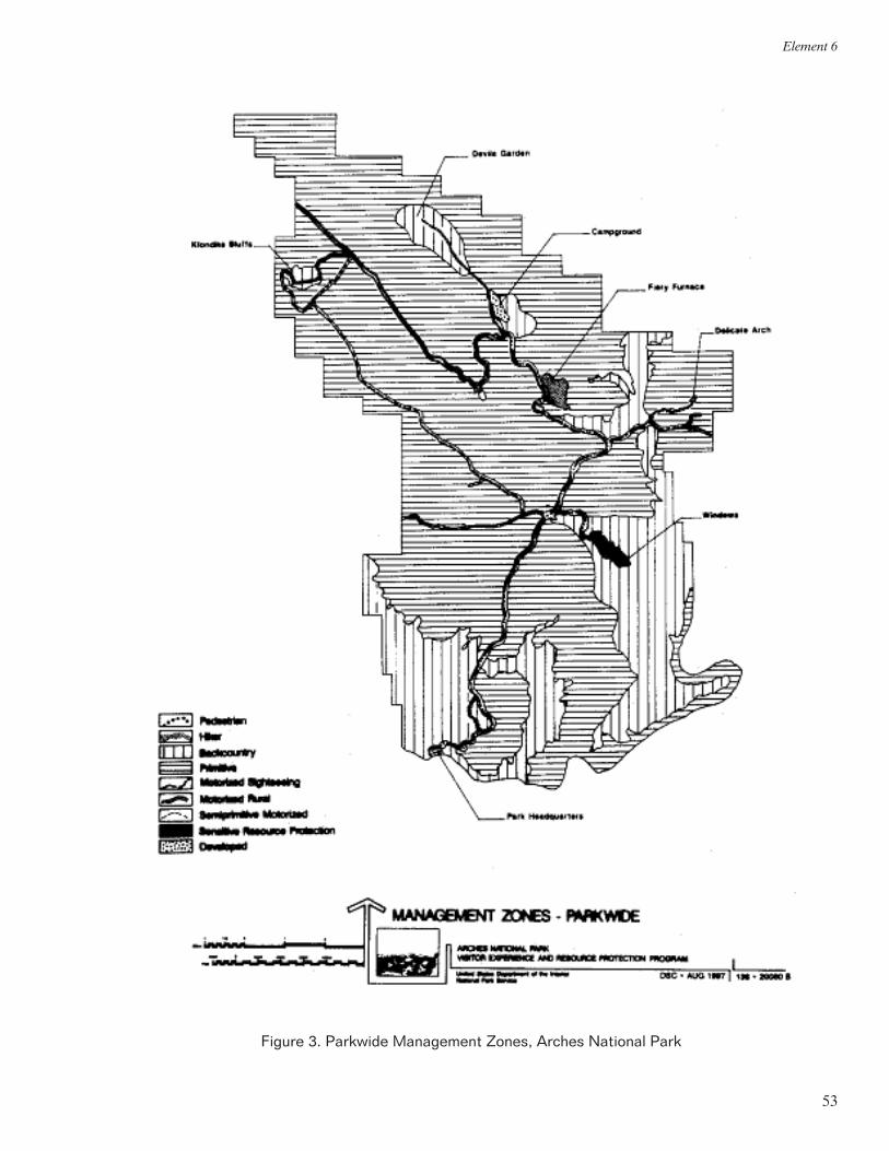
Element 6
Figure 3. Parkwide Management Zones, Arches National Park
53
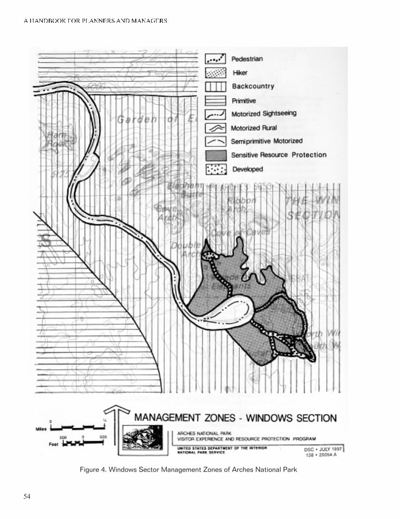
� �������� ��� �������� ��� ��������
Figure 4. Windows Sector Management Zones of Arches National Park
54
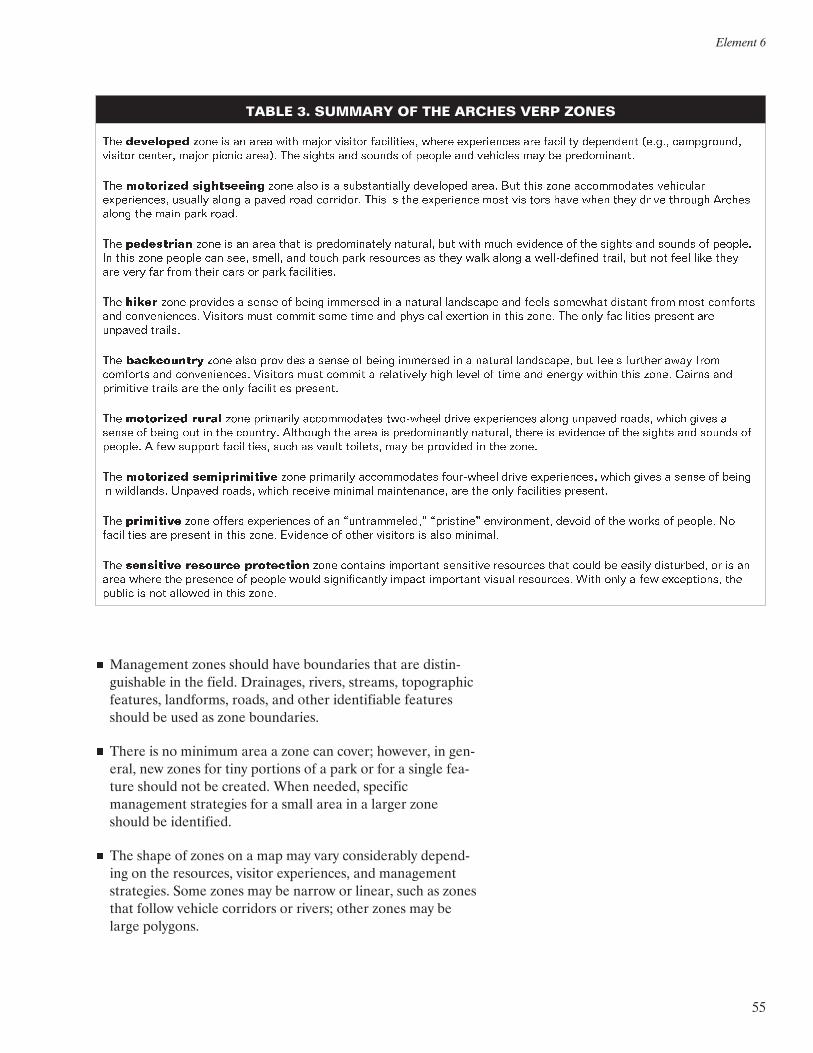
Element 6
TABLE 3. SUMMARY OF THE ARCHES VERP ZONES
��� ��������� ���� �� �� ���� ���� ����� ������� ����������� ����� ����������� ��� �������� ��������� ������ ����������� ������� ������� ����� ������ ������ ��� ������ ��� ������ �� ������ ��� �������� ��� �� ������������
��� ��������� ����������� ���� ���� �� � ������������� ��������� ����� ��� ���� ���� ������������ ��������� ������������ ������� ����� � ����� ���� ��������� ���� �� ��� ���������� ���� �������� ���� ���� ���� ����� ������� ������ ����� ��� ���� ���� �����
��� ���������� ���� �� �� ���� ���� �� ������������� �������� ��� ���� ���� �������� �� ��� ������ ��� ������ �� ������� �� ���� ���� ������ ��� ���� ������ ��� ����� ���� ��������� �� ���� ���� ����� � ������������ ������ ��� ��� ���� ���� ���� ��� ���� ��� ���� ����� ���� �� ���� �����������
��� ����� ���� �������� � ����� �� ����� �������� �� � ������� ��������� ��� ����� �������� ������� ���� ���� �������� ��� ������������� �������� ���� ������ ���� ���� ��� �������� �������� �� ���� ����� ��� ���� ���������� ������� ��� ������� �������
��� ����������� ���� ���� �������� � ����� �� ����� �������� �� � ������� ���������� ��� ����� ������� ���� ���� �������� ��� ������������� �������� ���� ������ � ���������� ���� ����� �� ���� ��� ������ ������ ���� ����� ������ ��� ��������� ������ ��� ��� ���� ���������� ��������
��� ��������� ����� ���� ��������� ������������ ��������� ����� ����������� ����� ������� ������ ����� ����� � ����� �� ����� ��� �� ��� �������� �������� ��� ���� �� ������������� �������� ����� �� �������� �� ��� ������ ��� ������ �� ������� � ��� ������� ����������� ���� �� ����� �������� ��� �� �������� �� ��� �����
��� ��������� ������������� ���� ��������� ������������ ���������� ����� ������������ ����� ����� � ����� �� ����� �� ���������� ������� ������ ����� ������� ������� ������������ ��� ��� ���� ���������� ��������
��� ��������� ���� ������ ����������� �� �� �������������� ���������� ������������ ������ �� ��� ����� �� ������� �� ���������� ��� ������� �� ���� ����� �������� �� ����� �������� �� ���� ��������
��� ��������� �������� ���������� ���� �������� ��������� ��������� ��������� ���� ����� �� ������ ���������� �� �� �� ���� ����� ��� �������� �� ������ ����� ������������� ������ ��������� ������ ���������� ���� ���� � ��� ����������� ��� ������ �� ��� ������� �� ���� �����
� Management zones should have boundaries that are distin
guishable in the field. Drainages, rivers, streams, topographic features, landforms, roads, and other identifiable features should be used as zone boundaries.
� There is no minimum area a zone can cover; however, in gen
eral, new zones for tiny portions of a park or for a single fea
ture should not be created. When needed, specific management strategies for a small area in a larger zone should be identified.
� The shape of zones on a map may vary considerably depend
ing on the resources, visitor experiences, and management strategies. Some zones may be narrow or linear, such as zones that follow vehicle corridors or rivers; other zones may be large polygons.
55
� �������� ��� �������� ��� ��������
An alternative is an understandable and
clearly articulated vision of future
conditions that is unified by a central
concept.
� When applying zones, the planning team should consider the land uses outside of the park. To the extent possible, the park zoning scheme should be compatible with land uses in areas adjacent to the park.
DEVELOPMENT OF ALTERNATIVES
For each planning effort, the team needs to determine if there are different visions or concepts for the future of the park that need to be considered and developed as alternatives. Alterna
tives may be formulated at several points in the planning process. Usually, the need to develop alternatives is recognized whenever planning participants — the planning team or the public — cannot reach a consensus on the outcome of one of the planning steps. For example, if one group of planning par
ticipants believes that park significance lies entirely with its cul
tural resources, while another group believes that park significance lies wholly with its biological/ecological resources, alternatives may need to be constructed around different park significance statements. GMP alternatives usually will consist of different zoning schemes driven by different concepts of the park’s future. Using a common set of potential management zones, different alternatives can be built by changing which zones are used and\or by changing the allocations of land in each zone. In some exceptional cases where only one zoning scheme is feasible, or all planning participants share a single vision of the future, alternatives may assess different manage
ment strategies for achieving the zoning scheme.
Unless alternatives have been formulated to assess different park purposes or significance, all alternatives must be consistent with the purpose and significance statements developed for the park (see element 3). Likewise, alternatives must comply with all other legislative mandates, NPS management policies, and applicable NPS guidelines. These statutory, regulatory, and pol-
icy constraints can be thought of as forming a corral as described in element 3. All potential alternatives must be screened carefully to ensure they fit in that corral; an alternative that does not fit should either be rejected or modified to meet those constraints.
When the VERP framework is being undertaken as part of a general management plan, alternative zoning schemes must be created and assessed. However, if the VERP framework follows an approved general management plan, the formulation of alternatives may not be necessary.
56
Element 6
POINTERS FOR DEVELOPING ALTERNATIVES
� The differences among alternatives should be clearly articu
lated in ways that will be apparent to decision makers, stake-
holders, and the public. The alternatives should be described in a parallel fashion using a similar outline for each alterna
tive and similar maps and graphics. Beneficial and adverse impacts should be assessed for each alternative. The reader should refer to the NPS Park Planning Guidelines and National Environmental Policy Act Guidelines for guidance on how to integrate NEPA requirements into a VERP plan.
� An alternative needs to have an underlying cohesive rationale or philosophy. Without a unifying concept, an alternative can-
not be easily explained to the public and defended; may be subject to the criticism of being arbitrary; and will likely not aid managers in making decisions to resolve unanticipated issues and problems.
� Alternatives that are driven by park infrastructure and size (big, bigger, biggest) rather than by desired visitor experi
ences and resource condition usually do not resolve problems resulting from increasing visitor use in the parks. More devel
opment can be proposed, but if visitor use levels continue to increase, the problem will manifest itself again in the future.
� Developing alternatives can be time-consuming, difficult, and frustrating work. Alternatives may go through many itera
tions. Some alternative concepts that were thought to be good ideas may be rejected once the planning team explores the concepts. The planning team should set aside time for this task and have patience.
57
Element 7 Select Indicators and Specify Standards for Each Zone; Develop a Monitoring Plan
Element 7 is a pivotal element because it marks the point at which the VERP framework moves from being qualitative to being quantitative. Once prescribed social and resource condi
tions are converted into variables that can be measured and monitored, a park staff can determine whether or not conditions are acceptable and take management action if needed.
The objective of element 7 is to select measurable characteris
tics or conditions that reflect the status of park resources and visitor experiences and to establish standards, which when main
tained, ensure that acceptable conditions are perpetuated
Developing indicators, standards, and a monitoring plan can be highly technical tasks, requiring knowledge about sampling design and data analysis. If a planning team does not have this expertise, the team may need to consult with experts inside or outside of the Park Service to ensure that the indicators, stan
dards, and monitoring plan are valid, reliable, and useful.
DEFINITION OFINDICATORS AND STANDARDS
Management zones are usually described in general, qualitative terms. Indicators and standards translate these qualitative descriptions into quantitative variables and measurements (e.g., “low volume trail use” is defined in zone ‘x’ as five encounters per day). While planners and managers may employ many dif
ferent kinds of indicators and standards for different reasons, in the VERP framework indicators and standards are based on the original LAC methodology.
Indicators are defined as specific, measurable physical, ecologi
cal, or social variables that reflect the overall condition of a zone. Resource indicators measure visitor impacts on the
58
Element 7
biological, physical, and/or cultural resources of a park; social indicators measure visitor impacts on the visitor experience.
Standards are defined as the minimum acceptable condition for each indicator variable. A standard does not define an intoler
able condition. It is not a condition that managers should strive to achieve, unless intolerable conditions already exist.
A brief example will help illuminate these definitions. A park zone may prescribe that resource conditions be largely natural and that social conditions offer visitors opportunities for soli
tude. These are broad, qualitative statements that provide a general description of a park zone. However, these descriptions are not specific enough to make decisions that could restrict public access. How “natural” do conditions have to be, for example, and how is “natural” to be measured? Likewise, with regard to social conditions, what constitutes “opportunities for solitude” and how is “solitude” to be measured?
Indicators and standards provide answers to these types of ques
tions. Based on various sources that are discussed later in this chapter, it may be determined that the amount of bare ground at campsites is a key measure of the naturalness of resource condition. Thus, the amount of bare ground at campsites may be a good resource indicator. Moreover, it may be determined that when the amount of bare ground exceeds 50% of the total campsite area, most visitors and agency personnel believe that impacts are unacceptable. Thus, the resource standard for bare ground at campsites in zone ‘x’ may be set at 50% of the total campsite area.
Similarly, it may be determined that the number of encounters with other groups along trails is a key measure of the opportuni
ties for solitude. Thus, the number of trail encounters with other groups per day may be a good social indicator. Moreover, most visitors may report that once they encounter more than three groups along a trail per day, they no longer have an acceptable level of solitude. Thus, the social standard for the number of trail encounters per day in zone ‘y’ may be set at three — a minimally acceptable social condition.
59
� �������� ��� �������� ��� ��������
INDICATORS
Sources of Indicators
Four sources of information exist for deriving indicators. Social and resource indicators can be identified by consulting the sci
entific literature, conducting original research, consulting public opinion, and applying management judgment. More than one source is usually needed to formulate indicators.
Consulting Scientific Literature. There is a large and growing body of scientific literature on the impacts of public use on parks and related areas. This literature addresses impacts on both resource and social conditions. For example, research on visitors to wilderness and related areas has often found that the ability to camp out of the sight and sound of other visitors is important in defining the quality of the visitor experience. Such findings might be suggestive of potential indicators for similar areas. However, the extent to which research can be generalized from one area to another is uncertain. Moreover, much of the research on visitor use impacts has been conducted in wilder
ness and backcountry areas. Thus, many types of parks are rela
tively unstudied. These limitations suggest that scientific literature can sometimes be useful in formulating indicators, but will usually have to be supplemented with other techniques or sources of information.
Conducting Scientific Research. Original scientific research conducted at the park under consideration is a potentially pow
erful source of indicators. Research can help determine which biophysical and experiential variables are important in main
taining the quality of resource and social conditions, respec
tively. This type of information can translate directly into indicators.
Research directed at identifying resource-based indicators gen
erally uses an approach that compares areas impacted by visi
tors to relatively unimpacted areas in similar ecosystems. This research approach assumes that when areas with similar resources (but different levels of use) are compared, variables that are found to be different are likely to be sensitive to visitor use; and therefore, are good potential indicators. Further refinement of these variables can lead to a set of resource indicators.
Research directed at identifying socially based indicators should focus on identifying aspects of social conditions (i.e., visitor use impacts, crowding) that are important in determining the quality
60
Element 7
of the visitor experience and that are subject to managerial influence. If more than one park zone or type of visitor opportu
nity is anticipated (which is likely), then this study should address each of those zones or opportunities. Visitors might be asked about the effects of other visitors on the quality of their experiences using both open- and close-ended questions. Open-
ended questions probe visitors for park conditions and issues that either add to or detract from the quality of the visitor expe
rience. Close-ended questions present a series of park condi
tions and issues and ask visitors to rate the extent to which an item adds to or detracts from the quality of the visitor experi
ence. This type of study can be administered to a representative sample of park visitors or it can take a more qualitative approach through the use of focus groups and other nonrepresentative samples.
Consulting the Public. Segments of the public often have strong opinions about the resource and social conditions that should be maintained in parks. These opinions can be useful in formulat
ing indicators. As discussed here, public involvement does not include scientifically based surveys of the public. This source of information is generally not fully representative of the public. Moreover, the public understanding of some technical issues, particularly those concerning resource-related impacts, may be limited. Thus, public involvement can be useful in formulating indicators, but should be supplemented with other sources of information.
Applying Management Judgment. A final source for formulat
ing indicators relies on the judgment of park planners and man
agers. Some judgment is needed in identifying indicators, even when the level of scientific knowledge is high. Park planners and managers typically have considerable experience with and knowledge of parks, which can help determine appropriate indi
cators for both resource and social conditions. They also have access to guidance in park legislation and approved planning and management documents that may help identify general indicators. However, research has shown that managers are not always knowledgeable about what visitors perceive and prefer. Moreover, managers cannot be expected to have technical knowledge about all aspects of resource and social conditions in their parks. These limitations suggest that management judg
ment is an important component of formulating indicators, but that it must be exercised in concert with other techniques or sources of information.
61
� �������� ��� �������� ��� ��������
Characteristics of Good Indicators
Indicators may vary widely among parks and management zones. However, there are eight characteristics that define good indicators.
• Specific. Indicators should define specific circumstances rather than general conditions. For example, “water qual
ity” would not be a good indicator for resource condition because it is too general. “Bacteria per volume of water” would be a better indicator of water quality. Similarly, “solitude” would not be a good indicator for social condi
tions because it is too general. “The number of other groups encountered per day along trails” would be a bet
ter indicator of solitude.
• Objective. Indicators should be objective rather than sub
jective measures — indicator variables should be meas
ured in absolute, unequivocal terms. Variables that are subjective, expressed in relative terms or subject to inter
pretation, make poor indicators. For example, “the number of people at one time at Wild Arch” is an objec
tive indicator because it is an absolute number that can reliably be counted and reported. However, “the percent-
age of visitors who feel crowded at Wild Arch” is a sub
jective indicator because it is subject to interpretation by visitors — it depends on the types of visitors making the judgement, the behavior of other visitors, and other vari
ables. Similarly, “the number of severely impacted camp-
sites” is a subjective indicator because the term “severely impacted” is relative and subject to interpretation. A more objective indicator would be “the number of camp-
sites that exceeds 20 square meters of bare ground.” This is not subject to interpretation and can be measured in absolute, unequivocal terms.
• Reliable and Repeatable. An indicator is reliable and re
peatable when measurement yields similar results under similar conditions. Because in most parks different staff members may be monitoring the same indicators on dif
ferent days or during different seasons, the indicator must also be reliable and repeatable when measured by more than one person.
• Related to Visitor Use. Indicators should be directly re
lated to at least one of the following visitor use attributes: levels of use, types of use, timing of use, location of use, or behavior of visitors. A major role of indicators is to help
62
Element 7
determine when management action is needed to control the impacts of visitor use. Thus, there must be a strong correlation between visitor use and selected indicators. For example, “the number of miles of eroded stream bank” would not be a good resource indicator on a river that is highly susceptible to flooding and natural erosion. “The number of social trails along the stream bank” would be a better indicator.
• Sensitive. Indicators should be sensitive to visitor use over a relatively short period of time. As the level of use changes, an indicator should respond in the same propor
tional degree. If an indicator changes only after impacts are substantial, it will not serve as an early warning mechanism, allowing managers to react in a timely man
ner. Ecological research suggests that the disturbance of ground cover vegetation usually occurs quickly under relatively low levels of visitor use. Thus, this variable might be a good indicator for resource condition. Social research suggests that backcountry visitors are especially sensitive to encounters with other groups at campsites. Likewise, this variable might be a good indicator for so
cial conditions.
• Resilience. Indicators should be responsive to, and help determine the effectiveness of, management action. Con
sequently, indicator variables should measurably respond quickly to changes in management. For example, an indi
cator of the condition of the soil surface may show quick response (i.e., recovery) when visitor trampling is cur-
tailed. In areas of higher rainfall, an indicator of vegeta
tion cover can often show a similar quick response to a drop in human traffic.
• Nondestructive. Indicators may need to be measured in-
frequently or frequently. But regardless of how often an indicator is measured, monitoring should not result in de
structive resource impacts or significantly detract from the quality of the visitor experience.
• Significant. Perhaps the most important characteristic of indicators is that they address prominent issues and man
agement concerns, such as visitor impacts that could af
fect park purpose or significance. The very term “indicator” suggests that they must be important in defin
ing the basic integrity of resource condition and the qual
ity of the visitor experience. It does little good to monitor the condition of an environmental variable that is
63
� �������� ��� �������� ��� ��������
generally unrelated to the larger concept of ecosystem integrity or is not a special resource, such as a rare plant population. Similarly, it is unproductive to monitor a social variable that is unimportant to visitors.
Selection of Indicators
In some cases a planning team may identify only a few potential resource or social indicators that can be monitored in a park. In other cases there may be many potential indicators, in which case the indicators need to be evaluated to select the “best” indicators.
Assuming the potential indicators meet all or most of the eight characteristics, the potential indicators can then be evaluated against a set of selection criteria. These are traits that would be desirable, but not critical, for an indicator. Listed below are seven recommended criteria for evaluating indicators. Addi
tional selection criteria may be added to the list depending on the park, and whether one is evaluating social or resource indi
cators. The recommended criteria are:
• Easy to Measure. Indicators should be relatively simple to measure. They also should be able to be measured relatively quickly and without sophisticated equipment. In general, the more expertise, time, equipment, and number of people needed to monitor an indicator, the less desirable it is.
• Easy to Train for Monitoring. There should be little, if any, formal training needed; monitoring personnel should be able to quickly learn how to monitor the indicator.
• Cost-Effective. Related to the above criteria, monitoring an indicator should be economically feasible, requiring a relatively low expenditure of park funds.
• Minimal Variability. Ideally, an indicator should show minimal variability based upon fluctuations in the envi
ronment. Indicators with less natural variation will be more sensitive to visitor impacts and more useful than those with more natural variability. If indicators have a large range of natural variation, the detection of changes caused by visitors will be difficult. For example, the change in a rabbit population probably would not be a good indicator because it has a lot of natural variability:
64
Element 7
the population changes annually in response to other natural factors (e.g., changes in the amount of food, cover, or the number of predators in an area) independ
ently of changes in visitor use.
• Response Over a Range of Conditions. Indicators should show a gradient in conditions, either due to the impacts of visitors or management actions. Variables that re
spond to small amounts of disturbance will enable a change to be detected earlier than variables that do not show change until major or irreversible damage has oc
curred. For example, an indicator would be better if it could respond to gradients between 0 and 100 than if it just responds to the two extremes.
• Large Sampling Window. There should be a large time frame when an indicator can be monitored (e.g., through the year or through a visitor use season).
• Availability of Baseline Data. Ideally, data should have been collected for the indicator in the past. Then new data that is collected can be compared to determine changes in resource conditions or visitor experiences.
A matrix can be a useful technique for rating potential resource and social indicators, with the evaluation criteria on one axis and the potential indicators on the other axis. An example of an evaluation matrix is shown in table 4. After determining the desirable criteria the planning team would fill in the matrix for each potential indicator, checking the cells if the criteria are met or rating the potential indicators on a scale based on how well the criteria are met. The more criteria a potential indicator sat
isfies, the more desirable it is.
65
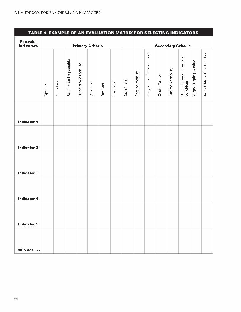
� �������� ��� �������� ��� ��������
TABLE 4. EXAMPLE OF AN EVALUATION MATRIX FOR SELECTING INDICATORS
��������� ���������� ������� �������� ��������� ��������
��������
���������
��������
���
����������
�������
��
������� ���
���������
���������
����������
�����������
����
��
�������
����
��
�����
��� ����������
��������������
������� �����������
�������� ���� �
�����
��
����������
�����
��������
������
������������
�� ��������
����
��������� �
��������� �
��������� �
��������� �
��������� �
��������� � � �
66
Element 7
STANDARDS
Characteristics of Good Standards
The scientific literature identifies five characteristics of good standards. These characteristics are not criteria that all stan
dards must meet, but they are true for most standards.
• Quantitative. Standards are quantitative. Since indicators are specific and measurable variables, standards should be expressed in an unequivocal way. For example, if a so
cial indicator is “the number of encounters with other groups per day on the river,” then the standard might be “an average of no more than three encounters with other groups per day on the river.” In contrast “low numbers of encounters with other groups per day on the river” would be a poor standard because it does not specify the mini-
mum acceptable condition in unambiguous terms. “Ten percent ground cover of exotic species” would be a quan
titative standard, while the “low cover of exotic plants” would be a poor standard.
• Time or Space-Bounded. Incorporating a time- or space-
bounded element into a standard expresses both how much of an impact is acceptable and how often such im
pacts can occur. It is often desirable for standards to have a time period associated with them. This is especially relevant for social conditions such as crowding-related is-
sues. For instance, in the above example, the standard for encounters with other groups on the river was expressed in terms of “per day.” Other time-bounded qualifiers might include “per night,” “per trip,” “per hour,” or “at one time,” depending upon the circumstances. Standards for resource condition are often time or spatially bounded. For instance, a standard of the acceptable num
bers of social trails may be stated in terms of distance, such as “four social trails per mile” or in terms of time such as “four social trails used per hour.”
• Expressed as a Probability. In many cases it will be ad
vantageous to include in the standard a tolerance for some percentage of the time that a particular condition will be unavoidably unacceptable; in other words, the standard would include a probability that conditions will be at standard or better. For example, a standard might say, “no more than three encounters with other groups per day along trails for 80% of days in the summer use sea-
son.” The 80% probability of conditions being at or above
67
� �������� ��� �������� ��� ��������
standard allows for 20% of the time that random or unusual events might prevent management from providing these conditions. This allows for the complexity and randomness inherent in visitor use patterns. In the example of encounters along the trail, several hiking parties might depart from a trailhead at closely spaced intervals on a given day. These groups are likely to encounter each other on the trail several times during the day. On another day, the same number of groups might depart from the trailhead at widely spaced internals and thereby rarely encounter each other.
Similarly, it might be wise to incorporate a tolerance in standards for peak days, holiday weekends, or other days of exceptionally high visitation. A standard might be set at “50 people at one time at Wild Arch for 90% of the year.” The amount of tolerance needed depends on the unpredictability of each individual situation and the degree to which management can consistently control conditions.
• Impact-Oriented. Standards focus directly on the im
pacts that affect the quality of the visitor experience or resource condition, not the management action used to keep impacts from exceeding the standards. For example, an appropriate standard might be, “no more than 10 en-
counters with other groups on the river per day.” This could be a good standard because it focuses directly on the impact that affects the quality of the visitor experi
ence — the number of other groups encountered. Alter-
natively, “a maximum of 20 groups per day floating the river” would not be a good standard because it does not focus as directly on the impact of concern — visitors are concerned about encounters, not the total number of groups floating the river. Basing standards on manage
ment techniques rather than on impacts can also limit the range of useful management solutions. For example, lim
iting the number of boaters to 20 per day might be used to ensure 10 or fewer encounters per day, but other ac
tions, such as more tightly scheduling launch times, could also ensure an appropriate encounter rate and could be less restrictive on the level of visitation to the river.
• Realistic. Standards must reflect conditions that are at
tainable. In some cases, managers or the public may pre
fer conditions that are better than can realistically be achieved. For example, an unrealistically low standard for encounter rates that prohibits most of the visitors from
68
Element 7
using the resource may not be politically feasible. Moreo
ver, such extreme measures that would place serious re
strictions on visitors may not be ethically defensible unless an extraordinary situation, such as imminent loss of a significant resource, would justify the action.
In some cases where existing conditions are significantly below standards (in a highly impacted natural area, for example), strict standards could be set even though achieving the standard could be many years in the future. A standard in this situation would be used to measure long-term improvement in conditions.
Setting Standards
All of the same sources noted for setting indicators — scientific literature, research, public opinions, and management judgment — also can be used by a planning team to identify and set resource and social standards. There are no specific criteria for setting standards, but there are several points that should be kept in mind.
Setting standards should involve input from scientists, manag
ers, planners, and the public. However, it should be understood that the process of setting standards is intrinsically subjective — there is no “right” standard. Decisions on standards should be made by understanding the tradeoffs and implications of the standards, using information from the public, and relying on whatever scientific data are available. Before standards are finalized, it is important to try to envision as clearly as possible the management actions that would be needed to keep stan
dards from being violated. For example, a management action required to address a standard out of compliance may create additional problems. If these problems outweigh the benefits of a stricter standard, a less stringent one may be defensible. The final decisions on standards will rely heavily on the best profes
sional judgment of scientists, planners, and managers.
In setting standards it is important to consider the degree of rigor and reliability that is needed by a park. The planning team needs to determine what data and level of analysis are needed for its VERP framework. For example, if the planning team anticipates that controversial decisions or highly restrictive man
agement action will occur after standards are set, more data and analysis may be needed than if decisions are anticipated to be less controversial.
69
� �������� ��� �������� ��� ��������
EXAMPLES OF POSSIBLE INDICATORS AND STANDARDS
Table 5 lists potential indicators and standards for resource and social conditions. It must be stressed that this is not a complete list. The examples, are offered for illustrative purposes only. Practitioners should always take into account the unique charac
teristics of different areas in parks when developing appropriate indicators and standards.
REVISION OF INDICATORS AND STANDARDS
A VERP plan should describe the process for updating and revising indicators and standards. Because the Park Service has little experience in applying indicators and standards in parks (particularly in frontcountry areas), a planning team may find it prudent to set provisional indicators and standards. These provisional indicators and standards (and the measurement techniques) can then be field tested to ensure they are valid, are feasible to monitor, and reflect what was intended by the planning team. Testing will often result in adjustments, even dropping indicators, after one or more field seasons. Some standards also may be determined to be indefensible or set at the wrong point based on bad data or incorrect judgments. With time, as more indicators and standards are applied in different zones and in more parks, provisional standards may no longer be necessary.
Once indicators have been adopted they generally should not change over the expected life of the general management plan, from which the VERP plan is tiered. However, there are situa
tions in which it may be desirable or necessary to change indica
tors. Park managers may decide to modify indicators if better ways are found to measure changes in resource or social condi
tions, if the indicators prove not to be sufficiently sensitive to measure changes caused by visitor use, or if the indicators prove not to be cost-effective to check regularly. If a different indica
tor is selected, a standard will have to be set for it. Managers should ensure that this change will not result in managing for resource or social conditions that are inconsistent with the con
dition specified in the management zone.
In most cases standards should not be changed during the life of an approved general management plan. The reason for stan
dards is to “draw a line in the sand,” which clearly shows when conditions are unacceptable and action must be taken. It defeats the purpose of the VERP framework if the line in the sand can
70
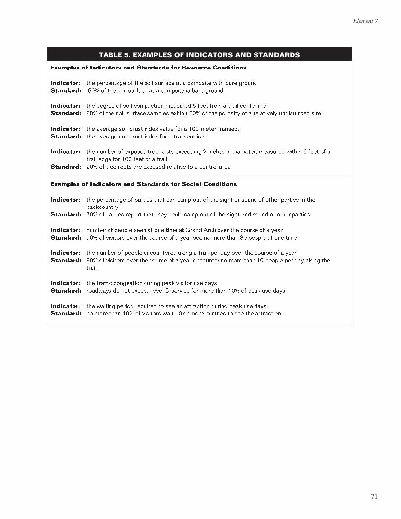
Element 7
TABLE 5. EXAMPLES OF INDICATORS AND STANDARDS
�������� �� ���������� ��� ��������� ��� �������� ����������
���������� ��� ���������� �� ��� ���� ������� �� � �������� ���� ���� ������ ��������� ��� �� ��� ���� ������� �� � �������� �� ���� ������
���������� ��� ������ �� ���� ���������� �������� � ���� ���� � ����� ���������� ��������� ��� �� ��� ���� ������� ������� ������� ��� �� ��� �������� �� � ���������� ����������� ����
���������� ��� ������� ���� ����� ����� ����� ��� � ��������� �������� ��������� ��� ������� ���� ����� ����� ��� � �������� �� �
���������� ��� ������ �� ������� ���� ����� ��������� � ������ �� ��������� �������� ������ � ���� �� � ����� ���� ��� ��� ���� �� � �����
��������� ��� �� ���� ����� ��� ������� �������� �� � ������� ����
�������� �� ���������� ��� ��������� ��� ������ ����������
���������� ��� ���������� �� ������� ���� ��� ���� ��� �� ��� ����� �� ����� �� ����� ������� �� ��� �����������
��������� ��� �� ������� ������ ���� ���� ����� ���� ��� �� ��� ����� ��� ����� �� ����� �������
���������� ������ �� ������ ���� �� ��� ���� �� ����� ���� ���� ��� ������ �� � ���� ��������� ��� �� �������� ���� ��� ������ �� � ���� ��� �� ���� ���� �� ������ �� ��� ����
���������� ��� ������ �� ������ ����������� ����� � ����� ��� ��� ���� ��� ������ �� � ���� ��������� ��� �� �������� ���� ��� ������ �� � ���� ��������� �� ���� ���� �� ������ ��� ��� ����� ���
�����
���������� ��� ������� ���������� ������ ���� ������� ��� ���� ��������� �������� �� ��� ������ ����� � ������� ��� ���� ���� ��� �� ���� ��� ����
���������� ��� ������� ������ �������� �� ��� �� ���������� ������ ���� ��� ���� ��������� �� ���� ���� ��� �� �������� ���� �� �� ���� ������� �� ��� ��� ����������
71
� �������� ��� �������� ��� ��������
change indiscriminately. However, there may be some extraordi
nary reasons for modifying a standard. Some possibilities might include
• the availability of new research information
• the initiation of a major planning effort
• a major change in technology
• a significant, unanticipated event occurring inside or outside the park boundary (e.g., a flash flood that destroys an important attraction or an oil shale boom that starts next to a park)
In no case should standards (or indicators) be changed simply because a park is out of standard or because the park staff wants to postpone difficult decisions. If a decision is made to change a standard, then the rationale for the decision should be clearly documented in a formal amendment to the VERP plan. The public generally should be informed of the proposed change, and opportunities should be provided for public input. Depend
ing on how changing the standard affects the human environ
ment, NEPA documentation also may be needed.
POINTERS FOR DEVELOPING AND SELECTING INDICATORS AND STANDARDS
� It is extremely important that the wording of indicators and standards be carefully crafted. Changing just a few words in an indicator or standard can have major repercussions. For example, changing a crowding indicator from people at one time during the peak hours of peak months to people at one time 90% of the year could dramatically change how often monitoring shows a park zone is out of standard. Terms such as “peak days,” “peak hours,” and “use season,” need to be clearly defined as part of the indicators and standards. Other-
wise, there may be confusion and uncertainty regarding the meaning and implications of indicators and standards.
� If research is needed to develop resource or social indicators and standards it should begin as early in the VERP planning process as possible. An ideal social research program may take two field seasons to complete, the first focused on identi
fying potential indicators and the second aimed at developing standards for those indicators.
72
Element 7
� For the Arches VERP plan, a two-tiered resource indicator system was adopted. This system was used because of the cost
and expertise needed to measure some of the indicators. Tier one included indicators to be measured more frequently, per-
haps annually. Tier two included indicators with high signifi
cance, but which would be too costly or too difficult to monitor frequently. Tier two indicators might be monitored only once every few years. These indicators would be expected to act as a check on the more simplistic tier one indicators until it is established that tier one indicators are sufficiently sensitive to the conditions being monitored.
� A question often associated with research on social indicators and standards concerns who should be included in surveys. Although it is usually impossible to include all groups in a sur
vey, some of the groups a planning team should consider including are current visitors, local residents, people who may have been displaced from the park, the general public (including people who may not visit the park), and interna
tional visitors.
� To detect change in some resource indicators, a comparison between disturbed and less disturbed areas may be needed. This “reference” or “control” approach involves some ele
ment of risk if the unimpacted areas cannot be protected from human-caused disturbance over the long term.
� Although data will help support decisions about which indica
tors and standards to use and will reduce the uncertainty of their implications, professional judgment will always play a critical role in the selection of indicators and standards. Therefore, judgments on indicators and standards must be rendered in a logical, traceable manner that is subject to pub
lic review and input.
� Monitoring requirements and management realities need to be considered in the selection of indicators and standards. Specifically, the timing, methods, and staffing demands of monitoring, and the display and analysis of monitoring data should be carefully considered during the selection of indica
tors and standards.
� There may be a tendency to accept existing resource and social conditions as standards. Standards can reflect existing resource and social conditions, but this judgment should be made only after careful thought and assurance that existing conditions represent agency and public visions for the future of the park.
73
� �������� ��� �������� ��� ��������
DEVELOPMENT OF A MONITORING STRATEGY
A VERP plan should document where, when, and how indica
tors will be monitored. Monitoring is the systematic and periodic measurement of indicators of resource and social conditions. Systematic means that a formal, explicit strategy exists that charts how, when, and where indicators will be monitored and how the data will be displayed. Periodic means that indicators are measured on a predetermined temporal interval, consistent with the values at stake, the decisions to be made, and the rele
vant science.
Monitoring plays three explicit roles in the VERP framework. First, monitoring helps park managers understand the status of resource and social conditions — if conditions are changing, or if conditions are approaching, at, or outside of standards.
Second, monitoring enables park managers to assess the effec
tiveness of management action. Management action often must be viewed as experiments. The ability of planners and managers to predict the consequences of actions is limited because there is much uncertainty about how people and natural or cultural resources interact. Monitoring provides feedback to managers about the consequences of specific management action. This feedback informs managers that their actions are appropriate, are solving problems, and should be continued. The feedback can also inform managers if their actions are not correcting the problems or are creating new problems.
Third, monitoring can provide a defendable basis for manage
ment actions that are implemented. Without data, park manag
ers have little on which to base their actions except a “gut” feeling that something is not right. With monitoring, managers can show how conditions have changed or document why cor
rective actions need to be taken. While management experience is an important element of decision making, in today’s world of conflict and litigation, subjective impressions of conditions are often no longer good enough. The public wants to see that monitoring data was collected, that it is reliable and defensible, and that it is understandable. Lacking an effective monitoring effort, park managers will likely have trouble responding to pub
lic concerns and criticisms if their actions appear controversial.
Three criteria should be kept in mind in developing a VERP monitoring strategy. A monitoring program needs to be:
74
Element 7
• Feasible. People and equipment are available to do the monitoring where and when it is called for and later to do the analysis of the data.
• Objective. The data are recorded in an objective, scientifically valid manner.
• Timely. Monitoring data provide information when park managers need it.
The energy required for monitoring is often the most underestimated aspect of developing a management plan that relies on indicators and standards. Monitoring is an ongoing, long-term undertaking. It requires an implementation schedule and protocol carefully designed to reduce bias and provide consistent, meaningful information about the dynamics of park resources and visitation. If properly conducted, monitoring will improve manager awareness of resource and social conditions, help guide and evaluate management actions, help anticipate emerging problems, and provide a mechanism for communicating changes in resource and social conditions in a park.
Monitoring often has not been successfully implemented in carrying capacity frameworks. In deciding to implement a VERP framework, a planning team and park staff need to examine the commitment for monitoring. If it is unlikely that a park staff or others will be able to monitor key resources and visitor experiences, the staff may want to reconsider proceeding with the development of a VERP framework.
Key Components of a Monitoring Strategy
A VERP monitoring strategy should include three key components.
• Description of the Monitoring Procedures. The strategy should describe the frequency, timing, and location of measurement activity as well as any specific instructions concerning how indicators will be monitored. For exam
ple, to monitor campsite encounters (e.g., the number of other groups camped in the sight or sound of each other), the procedures section would determine how many nights a certain number of campsites would be monitored for encounters. The process for monitoring campsite encoun
ters would be described and the data collection forms, if needed, would be provided. Similarly, to assess soil com
paction the procedures section would describe the instru
ments to be used, where to use them (offsite as well as onsite), how to use them, what period in the season to measure compaction, and what data to record.
75
� �������� ��� �������� ��� ��������
• Description of How Monitoring Data Will Be Analyzed and Displayed. The strategy should tell park managers what to do with the data they collect. The analysis and display of the monitoring data are determined by the in
dicators and standards identified earlier in the VERP plan. Thus, campsite encounters might be displayed as the mean number of groups camped within sight or be displayed as the proportion of group nights where more than two other groups within sight or sound are encoun
tered, depending upon how the indicator and standard for campsite encounters are defined. Typically, the data would be summarized in an annual monitoring report that park managers can easily read.
• Identification of Personnel. The strategy should explicitly identify the individual(s) or staff responsible for measur
ing indicators, analyzing data, and preparing an annual monitoring report. This section, then, integrates the VERP monitoring element into overall park manage
ment and identifies who is accountable for the park monitoring effort.
Where Resource and Social Indicators Should Be Monitored
One of the important points a monitoring strategy should address is where to monitor resources and visitors in a park. Resource and social conditions obviously do not need to be monitored everywhere in a park; a park staff also usually will not be able to monitor all indicators throughout a park. Thus, there is a need to prioritize where monitoring occurs. Monitor
ing is generally focused in zones where problems are acute or where the public has expressed concerns.
There are several guidelines to help identify where managers should focus their monitoring efforts.
• Monitor Where Conditions Are At or In Violation of Standard. When conditions are at or close to the limit of what is acceptable, monitoring needs to be conducted to determine when management action should be taken. If standards are already being violated, monitoring is needed to evaluate the effectiveness of the management action being taken and determine when conditions are back within standard.
76
Element 7
• Monitor Where Conditions Are Changing Rapidly. When change is occurring relatively rapidly (e.g., resource con
ditions are deteriorating or opportunities for solitude are decreasing), monitoring should be done to determine if and when management action is required. Monitoring is needed in these areas because the ability to predict the direction of change is limited, there may be significant uncertainties about the rate of change, and there may be important, but unpredictable, offsite implications associ
ated with the changes occurring.
• Monitor Where Specific and Important Values Are Threatened by Visitation. Resource conditions or visitor experiences may be threatened by recreational use in many areas, but some areas may be more important than others. For example, if solitude is an important experi
ence in a backcountry zone that is being threatened by the increasing levels of visitor use or the patterns of use, managers should monitor an indicator measuring soli
tude in that zone. On the other hand, solitude may not be currently threatened by visitor use in a different back-
country zone, and therefore, may not need to be moni
tored as closely.
• Monitor Where the Effects of Management Action Are Unknown. The level of knowledge about human/environ
ment interactions, particularly how management influ
ences social and resource conditions, is limited. In a sense, all management action is experimental. For exam
ple, while there has been considerable research on the ef
fects of visitors on soil and vegetation on campsite conditions, there has been little research on the effective
ness of various rehabilitation techniques. A number of variables, such as soil, moisture, vegetation, growing sea-
son, and the type and frequency of use, potentially influ
ence campsite rehabilitation efforts. Without monitoring, it may not be clear what effect closing a campsite to camping and reseeding native plants will have on site condition. Monitoring provides the systematic feedback that is needed when managers are unsure of the effects of their actions.
77
� �������� ��� �������� ��� ��������
When Indicators Should Be Monitored
The monitoring strategy also should identify when monitoring should occur. How frequently should indicators be monitored? What are the most appropriate and efficient times of the day, week, or year to monitor? When in a season should campsite impacts be measured? When should trail encounters be meas
ured — on the “average” day, on peak days, or on randomly selected days in the season? What is lost if monitoring has to occur in a relatively ad hoc fashion?
The preceding guidelines also pertain to when monitoring should occur. Managers may want to monitor indicators, or monitor them more frequently, when conditions are near or close to standard or are changing rapidly; when specific and important values are threatened; when information is lacking; or when the effects of management are unknown. Additionally, if a major disturbance occurs in or outside a park, or there are major social changes, park managers may want to monitor resource condition and/or visitor behavior.
The standards written by the planning team will often guide the timing of monitoring. For example, the following standard illus
trates when to monitor:
Visitation at Farview Overlook will not exceed 30 people at one time for more than 20% of the peak hours of peak use days during the summer season.
Assuming that peak times, peak days, and the summer season have been clearly defined, a monitoring schedule would be developed to sample a representative number of the peak hours of peak use days in the summer to estimate the percentage of time that the number of people at one time exceeds 30.
Another example of a standard that addresses when to monitor is the following:
Ninety percent of visitors in a year see no more than 30 people at one time at Wonder Geyser.
Assuming that the term “year” is clearly defined, in this case the standard would require that a representative number of visitors would be randomly sampled throughout the year. (If, however, visitor use tends to occur primarily during a few months of the year, a random, stratified, visitor sample may be required.)
78
Element 7
How Resource and Social Indicators Should Be Monitored
Many sources describe in detail how to monitor resource and social indicators. This section identifies several important points to keep in mind regarding who should monitor, how monitoring should be funded, and who should be responsible for a monitor
ing effort. Readers should refer to the sources in the Biblio
graphy for additional information on this subject.
• Funding a “new” monitoring effort may be seen as a daunting task, given limited budgets and staffing. Park staffs will need to aggressively seek out innovative ways to fund and operate a monitoring program, including finding new money sources (e.g., donations, grants from NPS and non-NPS sources), using “old” money pots (e.g., natural and cultural resource inventory/monitoring pro-
grams), and relying on non-monetary sources (e.g., vol
unteers). Other sources of funding could come from reprogramming (e.g., deciding what not to do in place of monitoring), and leveraging (e.g., using matching grants).
• Given limited agency resources, managers may want to consider monitoring different parts of a park using a ro
tation or tiered system. Immediate and annual monitor
ing may need to be done on those areas close to or out of standard. Other areas that may be approaching a stan
dard or have other emerging needs (but not as pressing as the first tier) may be monitored every two or three years. A third tier of areas that appear to be in good shape and are not experiencing rapid change may be monitored on a less frequent schedule, perhaps every five years. Alternatively, if managers can realistically monitor conditions only in a fourth of the park each year, then a four-year monitoring rotation may be a good starting point.
• The description of monitoring procedures in the monitor
ing strategy should be clear and simple enough that a person who was not involved in preparing the strategy could accurately measure the variable being monitored.
• Monitoring procedures and methods will be largely dic
tated by the indicator being measured, the type of site and the use that is being monitored, and the amount of fiscal and human resources dedicated to the task. There are numerous methods that can be used to monitor re-
source and social conditions, including trail counters
79

� �������� ��� �������� ��� ��������
(with or without video cameras), permit systems, self-
registration stations, remote sensing, and visual observations by managers, volunteers, or visitors.
80
Elements 8 & 9 Monitor Resource and Social Indicators and Take Management Action
Elements 8 and 9 shift the focus of activities from preparation and planning to the implementation of actions. During this phase, the indicators identified are monitored according to the monitoring plan(s) developed in element 7. The condition or status of indicators then are evaluated against the established standards, and decisions are made as to what, if any, management action is warranted.
MONITORING
The effective monitoring of resource and social indicators provides the feedback and documentation needed to implement meaningful management action. Monitoring, and the analysis of monitoring data may identify one of two situations that should trigger corrective actions.
Deterioration. One situation that would trigger action would be monitoring data that document how resource or social conditions are deteriorating over time, i.e., a trend is identified that shows conditions are moving toward the standard. Management action may, and perhaps should, be taken to slow or reverse the trend. In this case conditions are still better than standard, and actions should be selected that will not restrict recreational access to any substantial degree. Remember that in the LAC process the ultimate constraining goal (environmental conditions and visitor experiences) may be compromised to the standard before the second goal (unrestricted access) may be compromised substantially.
Out of Standard. The second situation that would trigger management action would be monitoring data showing that resource or social conditions are out of standard, i.e., conditions are unacceptable. In this case, management action may be taken that restricts or modifies recreational use to the degree necessary to restore and maintain acceptable conditions.
81
� �������� ��� �������� ��� ��������
Another way to think about monitoring and management action is to liken monitoring results to a traffic light. A green light indi
cates that park conditions are within standard, which means that no changes in management are required. A yellow light indicates that conditions are deteriorating and are approaching a stan
dard, which alerts managers to consider taking preventive action (either nonrestrictive or minimally restrictive action). A red light indicates that park conditions have violated a standard, which requires managers to take action and signals the use of more restrictive actions.
What actions may be considered to restrict or not restrict access to recreational opportunities will vary according to different set
tings, different values held by park users, existing visitor use lev
els and access, and other situation-specific factors. It will be the responsibility of planners and managers to involve the public in determining what kinds of management actions will be appropriate to take when conditions are deteriorating (but remain within stan
dard), and what actions will be appropriate when conditions are out of standard.
Before taking any corrective action, it is important to identify as clearly as possible the root causes of why conditions are deterio
rating. Numerous factors may be responsible for deterioration, including the type and level of visitor use, the timing of use, park management, and existing infrastructure (e.g., trail design, information programs, the location of visitor centers). Some-
times the root causes of unacceptable conditions may underlie more obvious symptoms. For example, an obvious probable cause of a trail encounter standard being exceeded is that too many people are using a particular trailhead. But perhaps the root cause of the existing condition is the design of the access road and parking areas that funnel people onto this trail. Or perhaps the condition is due to a park brochure that publicizes this trailhead and not others. If the root causes of existing con
ditions are not accurately identified, management action may be misdirected, with less than satisfactory results.
RANGE OF POSSIBLE MANAGEMENT ACTIONS
Several decades of research, management experience, and dis
cussion have identified a variety of strategies and tactics that can be taken to address resource or experiential impacts resulting from recreational use. To assist park managers in determining what actions might be most effective under various circum
stances, the National Park Service commissioned the
82
Elements 8 & 9
development of a decision-making handbook for addressing visi
tor use related problems. Much of the following information is taken from the handbook being developed.
The handbook identifies five general management strategies that managers can use to address recreational use impacts
• increase the supply of recreational opportunities, areas, and facilities to accommodate increased demand
• reduce public use at specific sites, in individual manage
ment zones, or throughout the park
• modify the character of visitor use by controlling where the use occurs, when the use occurs, what type of use oc
curs, or how visitors behave
• alter visitor attitudes and expectations
• modify the resource base by increasing the durability of the resource or by maintaining or rehabilitating the resource
Not all strategies are appropriate in all settings and situations. For example, increasing the number of visitor facilities may not be an appropriate strategy for wilderness or backcountry areas, depending on legislative constraints, specific management objectives, and existing visitor use levels. However, managers are encouraged to consider employing as many strategies as pos
sible to address specific impacts. Using a combination of strate
gies provides managers with greater flexibility and allows them simultaneously to address the multiple dimensions and the causes of undesired impacts. Reducing use may appear to be the obvious solution to visitor use impacts, but managers should remember that a less restrictive strategy may work as well and have fewer repercussions to visitors and park management.
In the five strategies, there are many specific management actions or tactics that can be used. These tactics fall into five general categories
• site management (e.g., facility design, the use of vegeta
tion barriers, site hardening, area/facility closure)
• rationing and allocation (e.g., reservations, queuing, lot
teries, eligibility requirements, pricing)
83
� �������� ��� �������� ��� ��������
• regulation (e.g., the number of people/stock, the location or time of visits, activity, visitor behavior, or equipment)
• deterrence and enforcement (e.g., signs, sanctions, personnel)
• visitor education (e.g., promote appropriate behavior, en-
courage/discourage certain types of use, provide informa
tion regarding use conditions)
When considering which management tactic, or combination of tactics, to employ there is no easy answer or standard formula. What to do is driven by the specified objectives for a particular area or management zone. These objectives often help to focus the range of options that managers can employ.
To aid planners and managers in selecting among the many management tactics, there are several questions or selection cri
teria that may make decisions easier. Answers to these and related questions can help to assess the trade-offs or the costs of competing actions:
• Does the tactic adequately address the underlying cause of the impact or visitor use problem?
• How effective is the tactic likely to be in resolving the im
pact in question?
• Is the tactic likely to lead to the creation of new problems?
• Is the tactic subtle or obtrusive in terms of visitors being aware that they are being managed?
• Is the tactic direct or indirect in terms of how it impacts or influences visitor behavior?
• Does the tactic preserve visitor freedom of choice?
• Does the tactic affect a large or small number of visitors?
• Does the tactic affect an activity to which some visitors attach a great deal of importance?
• Are visitors likely to resist the management action?
84
Elements 8 & 9
• What are the costs to managers in implementing and ad-
ministering the tactic?
After considering these and other questions, and weighing the trade-offs, park managers should select the strategies and tactics that best suite their situation and that they believe will most effectively address visitor impacts while minimizing total costs to managers, visitors, and resources.
POINTERS FOR SELECTING MANAGEMENT TACTICS
� Fit the solution to the problem. Have a clear understanding of the objectives that define the problem. Do not find yourself in a situation where you have a solution in search of the problem!
� Recognize that most management action can have immediate and significant effects on the character of the area and on the kind of recreational opportunity or benefit offered. For exam
ple, drastic or even seemingly subtle changes in the design and type of facilities can alter the character of the site to the point that it may no longer be satisfactory to many current visitors. For instance, “creeping campground development” can change a small, informal site into a large, intensively developed site, which could force out those campers who sought out that campground because of its solitude and close
ness to nature.
� In wilderness and related backcountry settings, provide as much freedom as possible for people to roam; control only at accesses if possible. Even in frontcountry settings, actions that are subtle and seemingly unobtrusive are much more sup-
ported by visitors than are direct, more obtrusive measures.
� Timing is crucial for trip planning. Because most people plan before leaving home, get information to them as far in advance of their visit as possible. For a variety of reasons, the public is motivated to make preparations long before arriving at parks and recreational areas. There is considerable evi
dence that people would be receptive to new types of infor
mation and information delivery systems to aid their trip planning, to educate them about resource protection needs, and to build support for agency management programs.
� An even distribution of visitor use is unrealistic. Using man
agement tactics to achieve even distributions of visitor use in
85
� �������� ��� �������� ��� ��������
most areas is neither desirable nor attainable. In most loca
tions, geography, access, historic use patterns, and other fac
tors would thwart efforts to spread out use more evenly. Also, for many locations it would be desirable to offer a variety of recreational opportunities in the area. Establishing distinctive management zones to provide such diversity is a goal for many areas and is a fundamental construct of the VERP framework.
� Providing a range of recreational opportunities in a region is desirable to satisfy the diversity of recreational tastes. Manag
ers should establish objectives, standards, and strategies for an area that will result in a seemingly balanced spectrum of opportunities in a geographic region. No one manager or agency should feel obligated to meet the demands of all rec
reational users. Each agency, for example, could aim at pro
viding one or more specific types of recreational opportunities and refer those wanting something different elsewhere. Obviously, regional collaboration among private and public managers is mandatory if a full and appropriate mix of opportunities is to be provided.
� Selecting appropriate management tools and tactics is a value judgment. Ultimately, managers are left with the difficult decision of deciding how much visitation is appropriate, what kinds of activities are acceptable for a given area, and how visitor use is to be managed. For some decisions, the appro
priate course of action is clear because there are few alterna
tives. More frequently, information necessary to decide is meager and/or conflicting. Political, administrative, legal, budgetary, and resource constraints influence decisions, as well. While research and managerial experience can help, such information only reduces the range of uncertainty associ
ated with the decision. It does not eliminate it!
86

Appendix A Description of the Resource Experience Opportunity Areas Developed for the Arches VERP Implementation Plan
Fins. This opportunity area includes the Devils Garden, Fiery Fur
nace, Klondike Bluffs, and Herdina Park areas. They are domi
nated by the orange-to-reddish Entrada sandstone fins and spires. In these areas there are labyrinths of spires, fins, chutes, and arches. The visitor experience in this opportunity area is very much inwardly focused because of the high vertical landforms that limit movement and views along narrow corridors. The immediate fore-
ground and focused corridor views of landforms dominate the experience; in contrast, the importance of color and vegetation cover is minimal.
Monoliths and Walls. This opportunity area is primarily composed of the most striking non-arch landforms in the park. Courthouse Towers, the Great Wall, the Windows section, and the Delicate Arch area. The experience is not one of being in an area but rather that of viewing from the outside the massive to delicate landforms as they appear against the horizon. The opportunity for experienc
ing them is from the perimeter of the individual landforms. Because of the massiveness, height, and association in clusters, they provide key landmarks and orientation for the visitor. The land-
forms here also dominate expansive vistas that are afforded in other areas. Vegetation has a relatively minor role in defining the visitor experience.
Upland Blackbrush Flats. This opportunity area covers most of Willow Flats. These areas are generally flat, with some relief, and appear sandy or rocky. They have few distinguishable geologic fea
tures. Low, dark, blackbrush dominates the landscape. The vegeta
tion can appear to be an obstacle, and there are no obvious routes through the areas.
Slickrock/Petrified Dunes. Most of the southern part of the park is included in this opportunity area. It appears to be a smooth, rounded, rolling, tan-beige, rugged, barren, rock landscape. Depending on one's location in this area, one can see expansive vis
tas then move a few steps and feel much more enclosed by the dunes. Vegetation is scarce, with pockets of piñon-juniper
87
� �������� ��� �������� ��� ��������
vegetation and pothole gardens, and plays a relatively minor role in the visitor experience. There are a lot of opportunities for solitude here, and the landscape appears challenging to explore.
Broad Open Grassland Valley. This opportunity area is found in the northwestern end of Salt Valley. There is a more or less con
tinuous vegetative cover, primarily cheat grass. The valley is very open and flat, with few distinguishing topographic features. There is a moderate sense of enclosure with the valley walls off in the dis
tance. The area appears to be uninteresting and uninviting — most people pass through this area to get someplace else.
Rolling Topography Mixed Shrub Valley. This arid area is found in the southeastern end of Salt Valley. There are no distinguishable landmarks or routes through it. The landscape appears to be mildly undulating with rounded, eroded hills. Mancos shale and yellow-
green-blue soils are present. The area is sparsely vegetated, with saltbush being the most common plant present.
Broad Open Shrubland Valley. This area covers Cache Valley. Similar to the above two opportunity areas, the broad open shru
bland valley is perceived as being flat with a vague sense of enclo
sure. There are no nearby landmarks. A mosaic of substrates (shale soil alternating with sandy soils) and a marbled mix of vegetation are present. Although there is not a continuous vegetative cover, shrubs dominate the landscape and can present a minor obstacle to traversing.
Ridge/Highlands. The ridge/highlands opportunity area includes the southwestern part of the park and the upper flanks of the southwest side of Salt Valley. This is a rocky area with expansive vistas and some moderately distinctive slopes and ridges that break the area into small visual units. There are distinctive landmarks off in the distance and some in the foreground. Although one is out
wardly focused when walking through here, one also is looking down at the vegetation to avoid it. The mix of plant communities found here plays a minor role in the visitor experience, although at times it can appear to be a barrier or obstacle to cross.
Wash/Canyon. Upper and lower Courthouse Wash and Salt Creek are included in this opportunity area. The experience here can vary from feeling tightly confined to being in a broad valley. Few vistas are evident. The areas generally feel relatively narrow and snake-
like with canyon walls. Once one is in this area it is challenging to get out other than to backtrack. There is an obvious route along the wash bottom. The area is interesting to explore because of the pres
ence of (or past signs of) flowing water, seeps, and relatively thick vegetation. There is a sense of wanting to explore what is beyond the next bend in this area. It can be easy to walk in some parts and difficult in other parts because of the presence of mud, quicksand, and impenetrable vegetation.
88

Appendix A
River Canyon. This is a very scenic, attractive, sinuous landscape. The silty waters of the Colorado River and the towering, dark red sandstone canyon walls dominate the landscape. One feels deeply enclosed in this canyon, with the experience being inwardly focused along the river corridor. The play of light and shadows along the rock faces attracts the eye. Tamarisk growing along the riverbanks is also evident and can affect the experiences of people trying to walk through it or take out their boats. Rugged talus slopes above the river make walking difficult through much of the canyon.
89
Appendix B Descriptions of the Management Zones in the Arches VERP Implementation Plan
Pedestrian Zone. The pedestrian zone is comprised of high use trail corridors that access prime park features. The areas in this zone are predominately natural, but with much considerable evidence of the sights and sounds of people. Visitors can see, touch, smell, and hear park resources as they walk along a well-defined trail, but they will not feel like they are far from their cars or conveniences. Paved or hardened trails and small interpretive structures are the only facilities present. Some trails would be accessible to visitors with disabilities. To use this area, visitors must make a short time com
mitment and physically exert themselves to some degree. There are limited opportunities for challenge and adventure, and the need for outdoor skills is relatively unimportant. The probability of encoun
tering visitors is very high, and moderate for encountering NPS staff; many people may be present. No vehicles or stock are permit
ted in this zone.
Visitors, sites, and trails are intensively managed in the pedestrian zone to ensure resource protection and public safety (e.g., with fences, intensive law enforcement, and restrictions on visitor activi
ties). Resources can be modified for essential visitor and park operation needs, but they are changed in a way that harmonizes with the natural environment. Except for these essential changes, Park Service tolerance for resource degradation here is low.
Hiker Zone. The hiker zone is applied to trail corridors and areas of a somewhat more primitive nature than those in the pedestrian zone. The hiker zone provides a sense of being immersed in a natu
ral landscape and feels somewhat distant from most comforts and conveniences. Unpaved, maintained trails, and sometimes cairned routes are the only facilities in this zone. Opportunities exist to experience challenge and adventure. Visitors must commit a block of time, have some outdoor skills, and expend some physical exer
tion to use the area. The probability of encountering other visitors is moderate to high (although there are opportunities for solitary experiences), and moderate for encountering NPS staff. No vehi
cles or stock are permitted here.
90
Appendix B
A high level of management is provided for resource protection and safety purposes in the hiker zone (e.g., placing stones along trail edges and restricting off-trail use and group sizes). Some resource modifications are evident, but they harmonize with the natural environment. The Park Service’s tolerance for resource degradation here is low.
Backcountry Zone. This zone encompasses lightly used areas of the park where visitors hike cross-country, along washes, or on primi
tive trails or marked routes. Like the hiker zone, the backcountry zone provides a sense of being immersed in a natural landscape but feels farther away from comforts and conveniences than the pedes
trian and hiker zones. No facilities are in this zone except for a few cairned routes and primitive trails. The use of this area requires a relatively long time commitment and high level of physical exer
tion. The environment offers a moderate to high degree of chal
lenge and adventure. Opportunities for independence, closeness to nature, tranquillity, and the application of outdoor skills are mod
erate to high. The probability of encountering other visitors and NPS staff is low. Vehicular use is not permitted, but stock use may be permitted in certain environments.
A moderate level of management is provided for resource protection and safety purposes. Subtle onsite controls and restrictions may be present, such as placing rocks along the trail edges, restricting off-trail use, and requiring that visitors demonstrate knowledge of environmental sensitivity before entering the zone. A few resource modifications may be evident, but they harmonize with the natural environment. The Park Service’s tolerance for resource degradation due to visitor use in this zone is very low.
To ensure that the backcountry zone remains largely without trails, a limit has been placed on the number of miles of primitive trails and cairned routes that can be provided for visitor access or resource protection purposes: no more than 5 additional miles (8 kilometers) of established routes, including trails on slickrock and washes, will be permitted in all of the park's backcountry zone. (There are currently about 5.5 miles [8.9 kilometers] of established routes in the zone.)
Primitive Zone. The primitive zone includes areas where very low use is desirable to protect views seen from adjacent zones, pristine resource areas, and the areas of the park that are difficult to access. Visitors in the primitive zone experience an untouched, primeval environment, devoid of the works of people. No stock are present, and no trails are evident. The use of this zone requires a relatively high degree of physical exertion and a long time commitment. The environment offers a moderate to high degree of challenge and adventure. Opportunities for independence, closeness to nature, tranquility, and the application of outdoor skills are high. There is a very low probability of encountering other visitors or NPS staff. Similarly, the evidence of other visitor impacts is minimal.
91
� �������� ��� �������� ��� ��������
Management for resource protection and safety in the primitive zone is very limited; the area is managed in such a way that onsite controls and restrictions are minimized and those that are present are subtle. However, offsite the management of visitors may be intensive (e.g., eligibility requirements that must be satisfied before one enters the zone, limits on the length of stay in the area, and reservation requirements). The Park Service’s tolerance for resource modifications and resource degradation here is very low.
Motorized Sightseeing Zone. The motorized sightseeing zone is a substantially developed area. The paved roads, pullouts, overlooks, and associated short trails and small picnic areas, parking areas, and other facilities that support visitor touring are included in this zone. The zone is a fairly narrow corridor. For monitoring pur
poses, the zone extends 50 feet (15 meters) from the edge of roads and pullouts.
The paved roadways and associated developments in the motorized sightseeing zone are used by visitors for touring the park, enjoying scenic overlooks and interpretive media, and gaining access into other park zones. Visitor attractions are convenient and easily accessible. The visitor experience is generally dependent on a vehi
cle or bicycle, involves driving along a well-maintained, paved road, and is perceived as being linear/ sequential and vicarious in nature. Observing the natural environment is important, and there may be a sense of adventure, but there is little need for visitors to physi
cally exert themselves, apply outdoor skills, or spend a long time in the area. The probability of encountering other visitors is very high, and moderate for encountering NPS staff; many visitors may be present. Some trails and most facilities would be accessible in this zone.
Intensive management is provided in the motorized sightseeing zone to ensure resource protection and public safety (e.g., with fences, intensive law enforcement, and restrictions on visitor activi
ties). Resources can be modified for essential visitor and park operational needs. The Park Service’s tolerance for resource degra
dation in this zone is moderate.
Because the number of social (i.e., unofficial) pullouts has grown over the past several years, it is necessary to identify the number of pullouts that will be allowed in the zone. In August 1994 the park staff identified 40 approved pullouts on 20 miles of paved roads, excluding Delicate Arch, for an average of two per mile. New pull-
outs may be developed if there is a documented need and traffic safety considerations permit; however, the total number of pullouts permitted along the paved roads will not exceed 48, which would be a 20% increase over the current conditions.
Motorized Rural Zone. This zone includes the maintained, unpaved, two-wheel-drive roads. Like the other motorized zones,
92
Appendix B
the motorized rural zone includes narrow areas alongside the roads.
The motorized rural zone accommodates two-wheel-drive experi
ences (although opportunities exist for nonmotorized forms of rec
reation) along unpaved roads, which gives visitors a sense of being in the country. Although the areas are predominately natural, there is evidence of the sights and sounds of people. A few support facili
ties, such as vault toilets, may be present. Visitors usually do not need to physically exert themselves, use outdoor skills, or make a large time commitment to use the area. Challenge and adventure opportunities associated with more primitive types of recreation are not very important. The probability of encountering visitors is moderate, and it is low for encountering NPS staff.
A high level of management is provided in this zone for resource protection and safety (e.g., with signs, barriers, and temporal restrictions). Resource modifications are evident, but they harmo
nize with the natural environment. The Park Service’s tolerance for resource degradation in the motorized rural zone is low.
Because the graded dirt roads in this zone can grow wider with time, due to visitors driving off the roads and maintenance work, it is necessary to specify road widths and approved pullouts. The Salt Valley road will be maintained at a width of no more than 20 feet (6.1 meters); the Klondike Bluff trailhead road will not be widened unless necessary, and in no case will it be wider than 20 feet (6.1 meters). (However, necessary drainage ditches may extend into adjacent zones.) There are currently two pullouts along the 10-mile (16 kilometers) Salt Valley road and none along the Klondike Bluff spur road. New pullouts will only be developed where there is a documented need and traffic safety considerations require a pull-
out to get parked vehicles off the roadways. No more than eight additional pullouts will be permitted along the Salt Valley road; no new pullouts will be permitted on the Klondike Bluff spur road.
Semiprimitive Motorized Zone. This zone encompasses the four-
wheel-drive roads in the park. Like the other motorized zones, the semiprimitive motorized zone encompass the roads and narrow areas that parallel the roads.
This zone accommodates four-wheel-drive experiences (although opportunities exist for nonmotorized forms of recreation), which gives visitors a sense of being in wildlands. Unpaved, minimally maintained roads are the only facilities present. Although visitors in vehicles usually do not need to physically exert themselves, they may need to use outdoor skills and make a relatively large commit
ment of time to use the area. The area offers moderate opportuni
ties for challenge and adventure. The probability of encountering other visitors is low, and it is very low for encountering NPS staff.
93
� �������� ��� �������� ��� ��������
Management for resource protection and safety purposes is moder
ate in this zone. Onsite controls and restrictions are minimal, and those that are present are subtle (e.g., berms, rocks, and vegeta
tion). Some resource modifications may be evident, but they har
monize with the natural environment. The Park Service’s tolerance for resource degradation in this zone is low.
As with the motorized rural zone, it is necessary to specify the widths of the roads because they can increase with time. In an August 1994 survey the park staff determined that the Four-Wheel-
Drive Road averaged 9 to 10 feet (2.7–3 meters) wide (except where it crossed the Klondike Bluffs Ridge and averaged 9 to 14 feet [2.7–4.3 meters] wide). The Willow Flats Road averaged just over 12 feet (3.6 meters) wide. The other two unnamed road spurs on the west boundary are maintained as two-track trails and do not have any widenings, pullouts, or improvements. The traveled por
tion of all these roads will be maintained at their current widths, except the Willow Flats road will be reduced to 12 feet wide. How-
ever, there are a number of widenings along the roads, outside of the two tracks, where one vehicle pulls over to park, let another vehicle pass, or bypass rocks and bad ruts. Although some of these wide areas are necessary in certain locations due to environmental factors, their number will be kept to a minimum (see also the later discussion on indicators and standards). In no case will a widening be over 12 feet wide (3.6 meters) and 30 feet (9.1 meters) long.
Sensitive Resource Protection Zone. This zone includes critical viewshed areas where the presence or evidence of people detracts from the park purpose of protecting both geologic features and the natural setting in which they occur. They also are areas that have been severely impacted by past use and where intensive restoration activities will be required.
The Park Service tolerance for additional resource degradation due to public use in the sensitive resource protection zone is zero. Con
sequently, with only a few exceptions people are not allowed in the zone. Researchers could be allowed access to the zone under spe
cial permit, park staff could enter the zone for resource manage
ment purposes, and users that are entitled to access under federal laws, such as the American Indian Religious Freedom Act, would be allowed to enter the zone under permit. Prohibiting public use in this zone will necessitate a very high level of management out-
side the zone (e.g., with fences, intensive law enforcement, and visi
tor education efforts).
Developed Zone. This zone includes areas with major visitor and administrative facilities. The park visitor center, headquarters, and administrative areas, campground, and picnic area are included in the developed zone. Also included in this zone is the area contigu
ous to the campground that campers use for family recreational activities.
94

Appendix B
Although buildings, structures, and the signs of people are pre-
dominant, there are natural elements present. The facilities are convenient and easily accessible; there is little need for visitors to physically exert themselves, apply outdoor skills, or make a long time commitment to see the area. Opportunities for adventure are relatively unimportant. Many of these areas offer opportunities for social experiences, and the probability of encountering other visi
tors or NPS staff is very high.
Resources are modified for visitor and park operational needs. Most facilities would be accessible to visitors with disabilities, and there might be some accessible trails. The Park Service’s tolerance for resource degradation here is relatively high. Visitors and facili
ties are intensively managed in this zone for resource protection and safety purposes (e.g., with fences, intensive law enforcement, and restrictions on visitor activities).
95
Glossary
Carrying capacity. As it applies to parks, carrying capacity is the type and level of visitor use that can be accommodated while sus
taining the desired resource and social conditions that complement the purpose of a park unit and its management objectives.
Indicator. Indicators are specific, measurable physical, ecological, or social variables that reflect the overall condition of a zone. Resource indicators measure visitor impacts on the biological, physical, and/or cultural resources of a park; social indicators meas
ure visitor impacts on the park visitor experience.
Management zone. A geographical area for which management directions or prescriptions have been developed to determine what can and cannot occur in terms of resource management, visitor use, access, facilities or development, and park operations. Each zone has a unique combination of resource and social conditions, and a consistent management prescription. Different actions will be taken by the Park Service in different zones with regard to the types and levels of uses and facilities.
Monitoring. Measuring resource and social conditions in a zone in order to evaluate whether or not existing conditions are within LAC standards.
Resource. Biotic, geologic, hydrologic, aesthetic, ethnographic, architectural, historic, and archaeological elements and features contained in a park. The mix of these resources help shape the visi
tor experience in a park.
Standard. Standards define the minimum acceptable condition of each indicator variable. A standard does not define an intolerable condition.
Visitor experience. The perceptions, feelings, and reactions a per-
son has while visiting a park.
96
Bibliography
CARRYING CAPACITY
Graefe, A. R., F. R. Kuss, and J. J. Vaske 1990 Visitor Impact Management: The Planning Framework. Wash
ington, DC: National Parks and Conservation Association.
Kuss, F. R., A. R. Graefe, and J. J. Vaske 1990 Visitor Impact Management: A Review of Research. Washing-
ton, DC: National Parks and Conservation Association.
Lime, D. W., ed. 1996 Congestion and Crowding in the National Park System. Min
nesota Agricultural Experiment Station Miscellaneous Pub
lication 86-1996. St. Paul, MN: Department of Forest Resources and Minnesota Agricultural Experiment Station, University of Minnesota.
Manning, R., D. Lime, M. Hof, and W. Freimund 1995 “The Visitor Experience and Resource Protection (VERP)
Process: The Application of Carrying Capacity to Arches National Park.” The George Wright Forum 12 (3): 41–45.
Manning, R., D. Lime, and M. Hof 1996 “Social Carrying Capacity of Natural Areas: Theory and Ap
plication in the U.S. National Parks.” Natural Areas Journal 16 (2): 118–127.
National Park Service, U.S. Department of the Interior 1995 Visitor Experience and Resource Protection Implementation
Plan for Arches National Park. Denver, CO: Denver Service Center.
Shelby, B. and T. Heberlein. 1986 Carrying Capacity in Recreation Settings. Corvallis, OR: Ore
gon State University Press.
97
� �������� ��� �������� ��� ��������
U.S. Forest Service, U.S. Department of Agriculture n.d. Proceedings. Limits of Acceptable Change and Related Plan
ning Processes: Progress and Future Directions. May 20–22, 1997, Missoula, MT, by S. F. McCool and D. N. Cole. Gen
eral Technical Report RMRS-GTR-in press. U.S. Dept. of Agriculture, Forest Service, Rocky Mountain Research Sta
tion. Ogden, UT.
1985 The Limits of Acceptable Change (LAC) System for Wilder
ness Planning, by G. Stankey, D. Cole, R. Lucas, M. Peter-
son, and S. Frissell. General Technical Report INT-176. Ogden, UT: U.S. Forest Service, Intermountain Forest and Range Experiment Station.
Wagar, J. A. 1964 The Carrying Capacity of Wild Lands for Recreation. Forest
Science Monograph 7. Washington, DC: Society of Ameri
can Foresters.
PUBLIC INVOLVEMENT STRATEGIES
Canadian Standards Association 1996 A Guide to Public Involvement. Etobicoke, Ontario, Canada:
Canadian Standards Association. Available on electronic disk from Canadian Standards Association, 178 Rexdale Boulevard, M9W 1R3, (416) 747-4000.
Creighton, James L. 1981 The Public Involvement Manual. Cambridge, MA: Abt
Books.
Also:
International Association of Public Participation Practitioners (IAP3)
P.O. Box 10146, Alexandria, VA 22310 (703) 971-0090, (703) 971-0006 (fax) E-mail: [email protected] web site: http://www.pin.org/~pin
National Park ServiceDenver Service Center, Resources Planning GroupP.O. Box 25287, Denver, CO 80225-0287
98
Bibliography
ANALYSIS OF RESOURCES AND VISITORS
Land Classification
Aberley, D., ed. 1993 Boundaries of Home, Mapping for Local Empowerment. The
New Catalyst Bioregional Series. Philadelphia, PA: New So
ciety Publishers.
Forest Service, U.S. Department of Agriculture 1978 A Landscape Inventory Framework: Scenic Analyses of the
Northern Great Plains by R. B. Litton, Jr., and R. J. Tetlow. Research Paper PWS-135. Berkeley, CA: Pacific Southwest Forest and Range Experiment Station.
Higuchi, T. 1989 The Visual and Spatial Structure of Landscapes. Cambridge,
MA: The MIT Press.
Zube, E. H., R. O. Brush and J. G. Fabos 1975 Landscape Assessment: Value, Perception, and Resources.
Community Development Series, Vol. 11. Stroudsburg, PA: Dowden, Hutchinson & Ross, Inc.
Tourism Planning
Gunn, C. A. 1988 Tourism Planning., 2nd ed. Philadelphia, PA: Taylor &
Francis.
Visual Resources
Forest Service, U.S. Department of Agriculture 1992 Forest Landscape Analysis and Design, A Process for Develop
ing and Implementing Land Management Objectives for Land
scape Patterns by N. Diaz and D. Apostol. Research Paper R6 ECO-TP-043-92. Portland, OR: U.S. Forest Service Pa
cific Northwest Region.
1994 Landscape Aesthetics, A Handbook for Scenery Management. Agricultural Handbook Number 701.Washington, D.C.: U.S. Forest Service.
Litton, R. B. Jr., R. J. Tetlow, J. Sorenson, and R. A. Beatty 1974 Water and Landscape. Port Washington, NY: Water Infor
mation Center, Inc.
99
� �������� ��� �������� ��� ��������
INDICATORS AND STANDARDS
Merigliano, L. 1990a “Indicators to Monitor the Wilderness Recreation Experi
ence.” In Managing America's Enduring Wilderness Resource, edited by D. Lime, 156–162. Proceedings of the Conference, Minneapolis, Minnesota, September 11–17, 1989. St. Paul, MN: Minnesota Extension Service, and Minnesota Agricul
tural Experiment Station, University of Minnesota.
1990b “Indicators to Monitor Wilderness Conditions.”In Managing America's Enduring Wilderness Resource, edited by D. Lime, 205–213. Proceedings of the Conference, Minneapolis, Min
nesota, September 11–17, 1989. St. Paul, MN: Minnesota Extension Service, and Minnesota Agricultural Experiment Station, University of Minnesota.
Roggenbuck, J. W., D. R. Williams, and A. E. Watson 1993 “Defining Acceptable Conditions in Wilderness.” Environ
mental Management 17 (2): 187–197.
U.S. Forest Service, U.S. Department of Agriculture 1992 Defining Wilderness Quality: The Role of Standards in Wilder
ness Management — A Workshop Proceedings, by B. Shelby, G. Stankey, and B. Shindler. Forest Service General Techni
cal Report PNW-GTR-305. Portland, OR: Pacific Northwest Research Station.
MONITORING
U.S. Forest Service, U.S. Department of Agriculture 1983 Monitoring the Conditions of Wilderness Campsites, by D.
Cole. Forest Service Research Paper INT-302, Ogden, UT: Forest Service, Intermountain Research Station.
1989 Wilderness Campsite Monitoring Methods: A Sourcebook, by D. Cole. Forest Service General Technical Report INT-259. Ogden, UT: Forest Service, Intermountain Research Station.
National Park Service, U.S. Department of the Interior 1991 Developing a Natural Resource Inventory and Monitoring Pro-
gram for Visitor Impacts on Recreation Sites: A Procedural Manual, by J. L. Marion. Natural Resources Report NPS/NRVT/NRR-91/06. Prepared by the Cooperative Park Studies Unit, Virginia Tech., Department of Forestry. Den
ver, CO: Denver Service Center.
100
Bibliography
Yuan, S., B. Maiorano, M. Yuan, S. M. Kocis, and G. T. Hoshide. 1995 Techniques and Equipment for Gathering Visitor Use Data on
Recreation Sites. Missoula, MT: Technology & Development Program, University of Montana.
MANAGEMENT ACTION
U.S. Forest Service, U.S. Department of Agriculture 1987 Managing Wilderness Recreation Use: Common Problems and
Potential Solutions, by D. N. Cole, M. E. Petersen, and R. C. Lucas General Technical Report INT-230. Ogden, UT: For
est Service, Intermountain Research Station.
1993 Wilderness Visitor Education: Information About Alternative Techniques, by J. E. Douchette and D. N. Cole. General Technical Report INT-295. Ogden, UT: Forest Service, In
termountain Research Station.
Manning, R. E. 1979 “Strategies for Managing Recreational Use of National
Parks.” Parks 4 (1): 13–15.
National Park Service, U.S. Department of the Interior 1993 Problems and Practices in Backcountry Recreation Manage
ment: A Survey of National Park Service Managers, by J. L. Marion, J. W. Roggenbuck, and R. E. Manning. U.S. De
partment of the Interior–Natural Resources Report NPS/NRVT/NRR-93/12. Denver, CO: Natural Resources Publication Office, National Park Service.
McCool, S. F. and N. A. Christensen 1996 “Alleviating Congestion in Parks and Recreation Areas
Through Direct Management of Visitor Behavior.” In Con
gestion and Crowding in the National Park System, edited by D. Lime. Minnesota Agricultural Experiment Station Mis
cellaneous Publication 86-1996. St. Paul, MN: Department of Forest Resources and Minnesota Agricultural Experi
ment Station, University of Minnesota.
Peterson, G. L. and D. W. Lime 1979 “People and Their Behavior: A Challenge for Recreation
Management.” Journal of Forestry 77 (6): 343–346.
101
� �������� ��� �������� ��� ��������
Vander Stoep, G. A. and J. W. Roggenbuck 1996 “Is Your Park Being ‘Loved to Death?’: Using Communica
tions and Other Indirect Techniques to Battle the Park ‘Love Bug’.” In Congestion and Crowding in the National Park System, edited by D. Lime. Minnesota Agricultural Ex
periment Station Miscellaneous Publication 86-1996. St. Paul, MN: Department of Forest Resources and Minnesota Agricultural Experiment Station, University of Minnesota.
Wang, T. L., D. H. Anderson, and D. W. Lime n.d. A Decision-Making Framework to Maintain Desired Resource
and Social Conditions in Recreational Settings. Prepared by the Cooperative Park Studies Unit, University of Minnesota, for the National Park Service (in progress). On file at the Denver Service Center.
102
Preparers
AUTHORS
Dr. Jayne Belnap, Research Biologist, U.S. Geological Survey, Bio
logical Resources Division, Canyonlands National Park Dr. Wayne A. Freimund, Assistant Professor, School of Forestry,
University of Montana Jim Hammett, Superintendent, John Day Fossil Beds National
Monument Jan Harris, Planner, Denver Service Center Marilyn Hof, Planner, Denver Service Center Gary Johnson, Chief of Resource Planning and Professional
Services, Blue Ridge Parkway Dr. David W. Lime, Senior Research Associate and Cooperative
Park Studies Unit Social Science Program Leader, Dept. of For
est Resources, University of Minnesota Dr. Robert E. Manning, Professor, School of Natural Resources,
University of Vermont Dr. Stephen F. McCool, Professor, School of Forestry, University
of Montana Michael Rees, Planner, Denver Service Center
OTHER CONTRIBUTORS
Dr. David N. Cole, Research Biologist, Aldo Leopold Wilderness Research Institute
Miki Stuebe, Landscape Architect, Denver Service Center Patricia Trap, Landscape Architect, Denver Service Center
PRODUCTION SERVICES
Joan E. Huff, Visual Information Technician, Denver Service Center
Leslie A. Peterson, Writer-Editor, Denver Service Center Anne C. Shewell,Visual Information Specialist, Denver Service
Center
103