visitor facilities - national park service visitor guide 2009.pdf · badlands visitor guide...
TRANSCRIPT
Park Planner National Park ServiceU.S. Department of Interior
Remember These Numbers . . .
7Number of days your passenger vehicle entrance pass permits you to explore the Badlands. Stay a little longer!
45Maximum speed limit on park roads. Lower speed limits are posted in heavy traffic areas.
100Minimum distance in yards you should keep from park wildlife. Any time an animal reacts to your presence means you are too close.
Index
Visitor Facilities & Local Services...........2
Accessibility........................................2
Rules, Regulations, & Safety ..................3
Park Contact Information.......................3
Park Paleontology...................................4
Park Geology..........................................5
Horse Use & Traveling Distances..........6
Park Map.................................................7
Hiking & Weather...................................8 Badlands Natural History Assoc...........9 Junior Rangers & Fees............................10
Exploring the South Unit.......................10
Minuteman Missile NHS.......................11
Ranger Programs..................................12 Road Construction Information..........12
Welcome to Badlands
The official newspaper ofBadlands National Park
2009 Issue
Badlands Visitor Guide
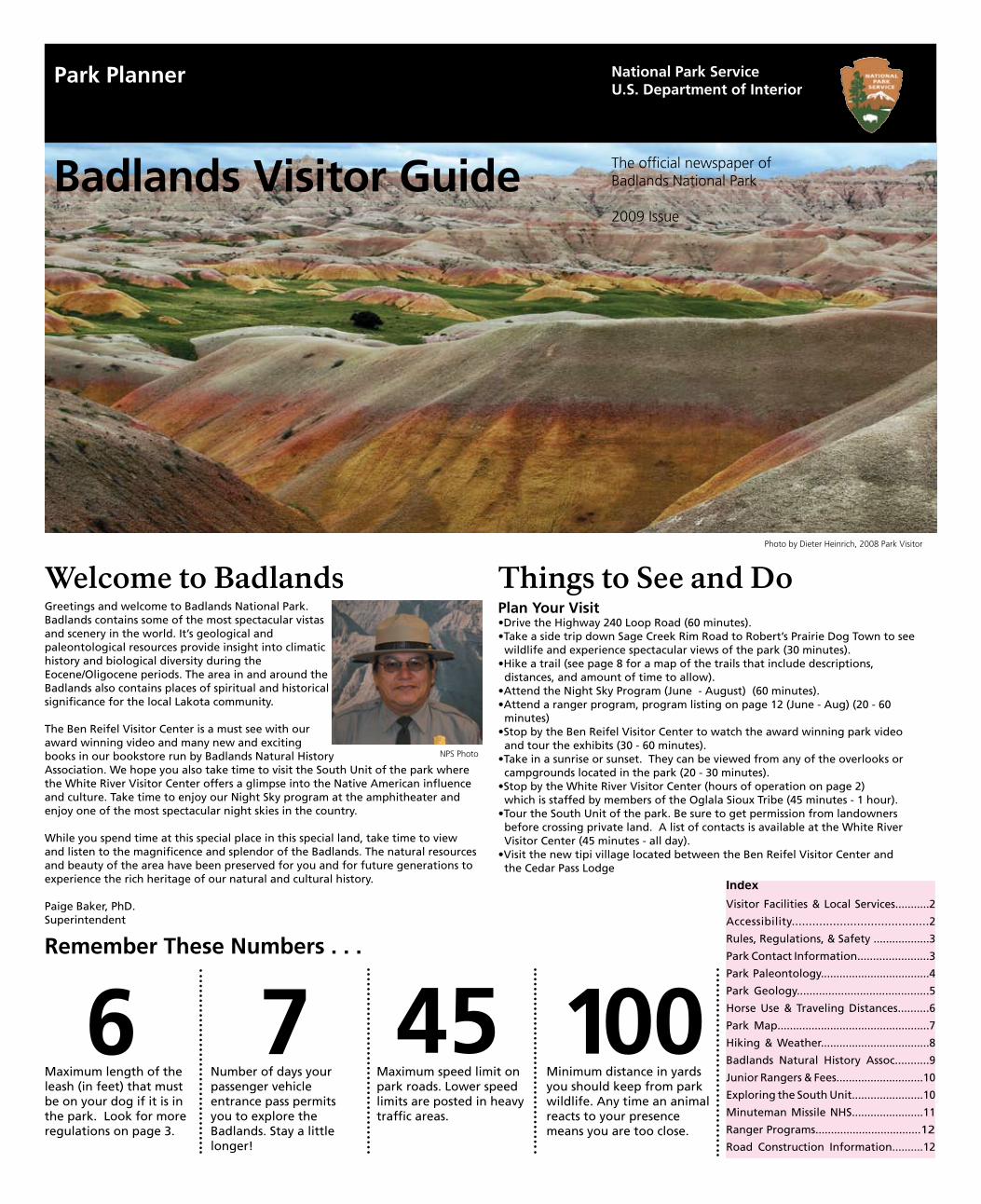
Greetings and welcome to Badlands National Park. Badlands contains some of the most spectacular vistas and scenery in the world. It’s geological and paleontological resources provide insight into climatic history and biological diversity during the Eocene/Oligocene periods. The area in and around the Badlands also contains places of spiritual and historical significance for the local Lakota community.
The Ben Reifel Visitor Center is a must see with our award winning video and many new and exciting books in our bookstore run by Badlands Natural History Association. We hope you also take time to visit the South Unit of the park where the White River Visitor Center offers a glimpse into the Native American influence and culture. Take time to enjoy our Night Sky program at the amphitheater and enjoy one of the most spectacular night skies in the country.
While you spend time at this special place in this special land, take time to view and listen to the magnificence and splendor of the Badlands. The natural resources and beauty of the area have been preserved for you and for future generations to experience the rich heritage of our natural and cultural history.
Paige Baker, PhD.Superintendent
Things to See and DoPlan Your Visit•Drive the Highway 240 Loop Road (60 minutes).•Take a side trip down Sage Creek Rim Road to Robert’s Prairie Dog Town to see wildlife and experience spectacular views of the park (30 minutes).•Hike a trail (see page 8 for a map of the trails that include descriptions, distances, and amount of time to allow).•Attend the Night Sky Program (June - August) (60 minutes).•Attend a ranger program, program listing on page 12 (June - Aug) (20 - 60 minutes)•Stop by the Ben Reifel Visitor Center to watch the award winning park video and tour the exhibits (30 - 60 minutes).•Take in a sunrise or sunset. They can be viewed from any of the overlooks or campgrounds located in the park (20 - 30 minutes).•Stop by the White River Visitor Center (hours of operation on page 2) which is staffed by members of the Oglala Sioux Tribe (45 minutes - 1 hour).•Tour the South Unit of the park. Be sure to get permission from landowners before crossing private land. A list of contacts is available at the White River Visitor Center (45 minutes - all day).•Visit the new tipi village located between the Ben Reifel Visitor Center and the Cedar Pass Lodge
6Maximum length of the leash (in feet) that must be on your dog if it is in the park. Look for more regulations on page 3.
NPS Photo
Photo by Dieter Heinrich, 2008 Park Visitor
May 9 - May 22 7 a.m. - 7 p.m.
May 23 - August 31 7 a.m. - 9 p.m.
Sage Creek Primitive Campground Open year round, access to this campground may be limited inwinter and during the spring rainy season due to road conditions. The Sage CreekRim Road is remote and unpaved. It is not recommended for large recreational vehicles. The campground is currently free and offers pit toilets and picnic tables. There is a four-teen day limit. There is no water available. Open campfires are not permitted.
Quick Facts about Badlands National Park •Established as a National Monument in 1939
•Redesignated Badlands National Park in 1978
•Acreage: 244,000
•Wilderness: 64,144 acres
•Visitation: approximately one million visitors each year from all over the world
Key Resources:•Largest expanse of protected prairie ecosystem in the National Park system•Considered one of the world’s richest mammal fossil beds•50% of Badlands National Park is co- managed with the Oglala Lakota Nation, the second largest American Indian Reservation in the United States•Badlands National Park and the Buffalo Gap National Grasslands are the most successful reintroduction sites for the black-footed ferret, one of the world’s rarest mammals.
Key Management Issues:•Visitor and employee safety •Reduction of exotic plant species•Protection of fossil resources •Maintenance of park facilities•Preservation of over 50,000 artifacts and specimens in museum collections•Reintroduction of native wildlife (pictured below)
Visitor FacilitiesBen Reifel Visitor Center Located at park headquarters the Ben Reifel Visitor Center reopened in 2006 with new exhibits, a 97 seat, air conditioned theater, a new park film, Land of Stone and Light, and improved classroom and restroom facilities. Badlands Natural History Association sells postcards, books, posters, and other educational materials. Open year round. Hours of Operation
April 19 - May 30 8 a.m. - 5 p.m.
May 31 - August 15 7 a.m. - 7 p.m.
August 16 - October 31 8 a.m. - 5 p.m.
Badlands National Park is in the Mountain Time Zone.
November 1 - April 2010 8 a.m. - 4 p.m.
White River Visitor Center Located on the Pine Ridge Reservation off Highway 27, this visitor center is operated by the Oglala Sioux Parks and Recreation Authority and is staffed by Tribal members. In 2007, new exhibits were installed by the National Park Service. Contact (605) 455-2878 for more information.
Hours of Operation
June 1 through September 15 10 a.m. - 4 p.m.
Picnic Areas Picnic tables are located at Bigfoot Pass and Conata Picnic Areas in addition to tables at the White River Visitor Center. Bigfoot Pass and Conata Picnic Areas do not have water available. Remember that open campfires are not permitted.
Local ServicesGas Stations and Convenience Stores •Cactus Flat •Rapid City •Interior •Scenic•Kadoka •Wanblee•Philip •Wall•Pine Ridge
Restaurants•Cactus Flat •Rapid City•Kadoka •Scenic•Philip •Wall•Pine Ridge
Motels and Campgrounds•Cactus Flat •Pine Ridge •Interior •Rapid City •Kadoka •Wall•Philip
Hospitals and Clinics•Kadoka •Rapid City•Philip •Wall
Post Office•Interior •Rapid City •Kadoka •Scenic•Philip •Wanblee•Pine Ridge •Wall
For more information about these local communities, contact the Chambers of Commerce or South Dakota Tourism.
Interior City Council (605) 433-5445Kadoka Chamber 1-800-467-9217 [email protected] Chamber (605) 859-2645 [email protected] Ridge Chamber (605) 455-2685 [email protected] City Chamber 1-800-487-3223 http://www.rapidcitycvb.comWall Chamber (605) 279-2665 http://www.wall-badlands.com-South Dakota Tourism (605) 773-3301 http://TravelSD.com
Black-footedFerret
Bison
Bighorn Sheep
Swift Fox
•The Ben Reifel Visitor Center and White River Visitor Center are both accessible to wheelchair users. Exam-ples of fossils and rocks provide a tactile ex-perience for all who enjoy handling objects, and is appropriate for the visually impaired.
•The Window Trail and the Door Trail are both accessible to wheelchair users.
•The Cedar Pass Campground has two accessible campsites. All campground restrooms are accessible. One group campsite is accessible.
•The Cedar Pass Lodge dining room and gift shop meet accessibility standards.
•Several summer ranger programs, including all talks and portions of the Geology Walk, are accessible to wheelchair users. Others include adaptations for visual or hearing impaired visitors. •Ask at the Ben Reifel Visitor Center about the listening devices that can be used to aid in hearing the park film.
•A complete listing of accessible facilities is available at the Ben Reifel Visitor Center or online at: http://www.nps.gov/badl/.
Accessibility
2
Cedar Pass Campground Located near the Ben Reifel Visitor Center, Cedar Pass Campground has 96 sites. Camping fees are $10 per night per campsite. The campground is oper-ated on a first come, first served basis and has a fourteen day limit. Cold running water, flush toilets, covered picnic tables, and trash containers are available. The campground does not have showers or electrical hookups. A dump station is available with a $1.00 fee per use. Campground hosts are on duty dur-ing the summer to assist with registration and provide information. Look for them in the afternoon and early evenings at the camp-ground entrance booth. Open campfires are not permitted.
GROuP CAMPING Four campsites are available in the Cedar Pass Campground for organized groups with a designated leader. The nightly fee is $2.50 per person with a minimum fee of $25.00. Advance reservations are required and can be made by contacting (605) 433 – 5235, (605) 279- 2357, or by writing Group Camping Reservations: Badlands National Park; 25216 Ben Reifel Road; P.O. Box 6; Interior, South Dakota 57750
Cedar Pass Lodge The only lodging, gift store, and restaurant in Badlands National Park, Cedar Pass Lodge provides visitors a distinctive collection of re-gional and handmade gifts, Native American crafts, and offers a memorable stay in this unique destination.
For additional information: www.CedarPassLodge.com or write Cedar Pass Lodge, 20681 Hwy 240, Interior, SD 57750; (605) 433-5460; fax (605) 433-5560
Gift Shop
Hours of Operation
April 18 - May 8 8 a.m. - 4 p.m.
Connie Wolf,Editor
September 1 - October 11 8 a.m. - 7 p.m.
NPS Photo
DianeHargreaves.com
DianeHargreaves.com
Photo by Teresa Zimmerman
Photo by Randy Matchett, uS Fish and Wildlife Service
The dining room closes 30 minutes before the gift shop.
Rules and Regulations Rules of the Road•The speed limit is 45 miles per hour, unless posted otherwise.
•Seatbelts are required for all passengers at all times.
•When viewing wildlife drive cautiously and use pull outs to allow others to pass safely.
•Keep vehicles on established roads. Do not park on the grass. The underside of your vehicle can start a prairie fire.
•Pedestrians have the right of way. Vehicles must stop for pedestrians in crosswalks. It’s the law.
•Gravel roads may be closed due to heavy rain or snow. They will become slick and impassable.
Protect Your Park
Camping and Campfires
•Campfires are not permitted due to the extreme danger of prairie wildfire.
•Camp stoves or contained charcoal grills can be used in the campgrounds or picnic areas.
•Wood gathering is not permitted.
•There are no hook-ups or showers available at the camp-grounds in the park.
Contact Us
Mailing Address Badlands National Park25216 Ben Reifel Road PO Box 6Interior, SD 57750 Park Websitewww.nps.gov/badl/
Park Headquarters605-433-5361
Fax Number605-433-5404
Backcountry Camping & HikingBefore you venture into the backcountry or wilderness, there are some things you should know:
•Permits are not currently required for overnight stays in the Badlands backcountry. Contact a staff member at the Ben Reifel Visitor Center or Pinnacles Entrance Station be-fore setting out on an overnight trip for more information. Backcountry registers are located at the Medicine/Castle Trail Loop, Saddle Pass Trailhead, Conata Picnic Area, Sage Creek Basin Overlook, and the Sage Creek Campground.
• Twisted or fractured ankles are the most common serious injury sustained in Badlands National Park. Make sure you are wearing sturdy boots with good ankle support. The park is home to many burrowing animals. Watch your footing.
• Campfires are not allowed under any circumstances. use a backpacking stove.
• Pets are not permitted on trails, in backcountry, or Wilderness Areas.
•The location of your campsite must be at least 0.5 miles from a road or trail and must not be visible from a roadway.
• There is little to no water available in the backcountry. The small amounts of water found are not drinkable or filterable due to the high sediment content. Always carry at least one gallon of water per person per day.
• All refuse must be carried out. use the cat hole method to dispose of human waste. Dig a small hole 6 to 8 inches deep and a minimum of 200 feet from any water source. Since animals will often dig up cat holes and scatter the toilet paper, it is preferred that you pack out any toilet paper used. If you must bury toilet paper, use a minimal amount and bury with at least 6 inches of soil. Strain food particles from wastewater, pack out food scraps, and scat-ter remaining water more than 200 feet from any stream channel.
• Check the weather forecast. Severe thunderstorms are common during the summer, so are days above 100ºF (38ºC). September and early October are the best back-packing months.
Pets
Bicycling
•Pets are allowed only on paved or gravel roads and in developed areas such as campgrounds.
•Pets must be kept on a leash no longer than six feet at all times.
•They are not allowed on trails or in public build-ings.
• Leaving an animal unattended and/or tied to an object is prohibited. Due to the extreme summer heat, do not leave your pet in your vehicle without leaving a window cracked at least several inches or without water.
• Pet etiquette dictates always cleaning up animal waste and disposing of it in trash receptacles.
Bicyclist Warning: The Badlands Loop Road is nar-row with many curves. Watch out for large RVs with extended mirrors.
•Bicycles are prohibited on park trails.
•Bicyclists are permitted on all park paved and unpaved roads and must obey all traffic regulations.
•Always ride with the flow of the traffic.
•Several steep passes make riding the Loop Road challenging.
•See and be seen. Wear bright colors and a helmet. A map of suggested routes is available at the Ben Reifel Visitor Center.
Emergency? Call 911
Road Conditions? Call 511
3
•Leave fossils, flowers, rocks, and animals where you find them. Collecting in the park is illegal and punishable by a fine and/or imprisonment. Report all unusual sightings and finds to park staff at the Ben Reifel or White River Visitor Centers. •Preserve your heritage. Do not enter, alter, or deface archeological sites. Do not collect artifacts.
•All vehicles and bicycles must travel on designated roads.
•It is recommended that you stay on designated trails in high use areas such as Fossil Exhibit and Cliff Shelf Nature Trails.
•Observe the speed limit and watch for wildlife crossing the roads.
•Help the park maintain its high air quality rating; turn off your engine when you are away from your vehicle. Letting your vehicle idle is punishable by a fine.
Hunting•Hunting is strictly prohibited in Badlands National Park.•State laws pertaining to firearms are strictly enforced.
Your Safety
• Summer is hot and dry. Carry and drink one gallon of . of water per person per day.
•Thunderstorms can produce lightning. During lightning storms, avoid lone trees and high places. Return to your car, if possible.
•Be careful on cliff edges and on badlands formations, especially when surfaces are wet.
•Wear clothing and sunscreen to protect yourself from the sun.
•Wear sturdy boots or shoes to protect your feet from cactus spines.
•Beware of the rattlesnakes that reside in the park. They can be found throughout the park and are venomous.Rattlesnakes avoid the sun by coiling in cracks and crevic-es or staying in the thick grasses. Wear closed toe leather shoes. Be careful where you place your hands and feet.
• Plan your trip carefully. use the Badlands Visitor Guide to choose a trail within your abilities. Make informed decisions.
• Be careful when exploring buttes. The rock surface is very unstable. Falls are the most common cause of injury in the park.
• Cell phones will not work in most of the park. Your safety depends on your own good judgement, adequate preparation, and constant attention.
• Winter weather can be very unpredictable. Sudden and dramatic weather changes are common. Check at the visitor center for weather updates.
• Protect yourself - dress in layers, watch for changing weather conditions, and let someone know about your travel plans.
NPS Photo
NPS Photo
4
Paleontology What is a fossil?
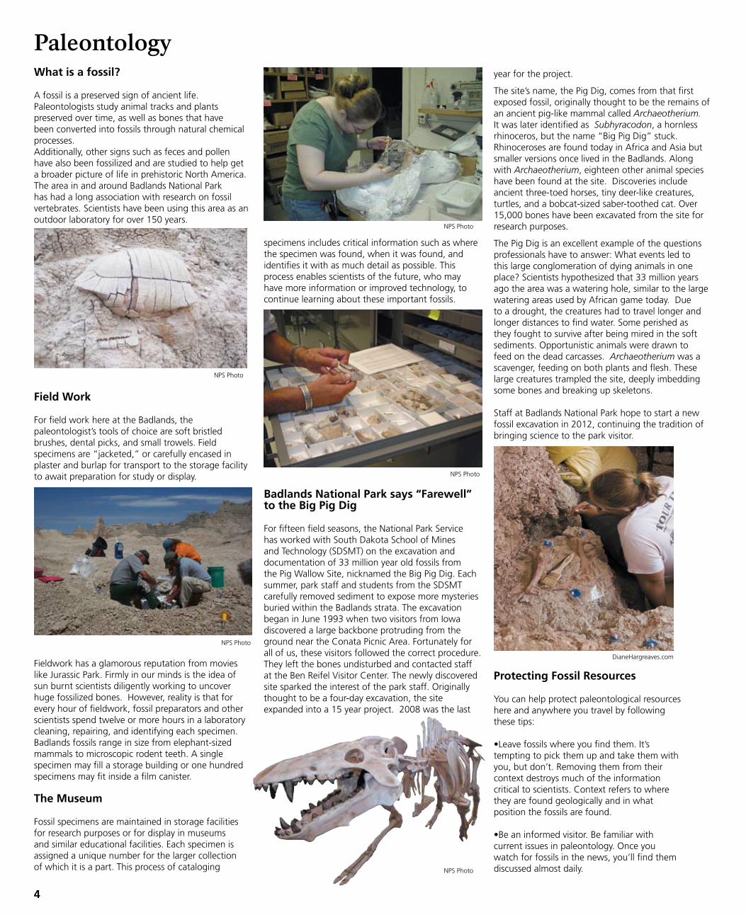
A fossil is a preserved sign of ancient life. Paleontologists study animal tracks and plants preserved over time, as well as bones that have been converted into fossils through natural chemical processes.Additionally, other signs such as feces and pollen have also been fossilized and are studied to help get a broader picture of life in prehistoric North America. The area in and around Badlands National Park has had a long association with research on fossil vertebrates. Scientists have been using this area as an outdoor laboratory for over 150 years.
NPS Photo
specimens includes critical information such as where the specimen was found, when it was found, and identifies it with as much detail as possible. This process enables scientists of the future, who may have more information or improved technology, to continue learning about these important fossils.
Field Work
For field work here at the Badlands, the paleontologist’s tools of choice are soft bristled brushes, dental picks, and small trowels. Field specimens are “jacketed,” or carefully encased in plaster and burlap for transport to the storage facility to await preparation for study or display.
Fieldwork has a glamorous reputation from movies like Jurassic Park. Firmly in our minds is the idea of sun burnt scientists diligently working to uncover huge fossilized bones. However, reality is that for every hour of fieldwork, fossil preparators and other scientists spend twelve or more hours in a laboratory cleaning, repairing, and identifying each specimen. Badlands fossils range in size from elephant-sized mammals to microscopic rodent teeth. A single specimen may fill a storage building or one hundred specimens may fit inside a film canister.
The Museum
Fossil specimens are maintained in storage facilities for research purposes or for display in museums and similar educational facilities. Each specimen is assigned a unique number for the larger collection of which it is a part. This process of cataloging
NPS Photo
Badlands National Park says “Farewell” to the Big Pig Dig
For fifteen field seasons, the National Park Service has worked with South Dakota School of Mines and Technology (SDSMT) on the excavation and documentation of 33 million year old fossils from the Pig Wallow Site, nicknamed the Big Pig Dig. Each summer, park staff and students from the SDSMT carefully removed sediment to expose more mysteries buried within the Badlands strata. The excavation began in June 1993 when two visitors from Iowa discovered a large backbone protruding from the ground near the Conata Picnic Area. Fortunately for all of us, these visitors followed the correct procedure.They left the bones undisturbed and contacted staff at the Ben Reifel Visitor Center. The newly discovered site sparked the interest of the park staff. Originally thought to be a four-day excavation, the site expanded into a 15 year project. 2008 was the last
year for the project.
The site’s name, the Pig Dig, comes from that first exposed fossil, originally thought to be the remains of an ancient pig-like mammal called Archaeotherium. It was later identified as Subhyracodon, a hornless rhinoceros, but the name “Big Pig Dig” stuck. Rhinoceroses are found today in Africa and Asia but smaller versions once lived in the Badlands. Along with Archaeotherium, eighteen other animal species have been found at the site. Discoveries include ancient three-toed horses, tiny deer-like creatures, turtles, and a bobcat-sized saber-toothed cat. Over 15,000 bones have been excavated from the site for research purposes. The Pig Dig is an excellent example of the questions professionals have to answer: What events led to this large conglomeration of dying animals in one place? Scientists hypothesized that 33 million years ago the area was a watering hole, similar to the large watering areas used by African game today. Due to a drought, the creatures had to travel longer and longer distances to find water. Some perished as they fought to survive after being mired in the soft sediments. Opportunistic animals were drawn to feed on the dead carcasses. Archaeotherium was a scavenger, feeding on both plants and flesh. These large creatures trampled the site, deeply imbedding some bones and breaking up skeletons.
Staff at Badlands National Park hope to start a new fossil excavation in 2012, continuing the tradition of bringing science to the park visitor.
Protecting Fossil Resources
You can help protect paleontological resourceshere and anywhere you travel by followingthese tips:
•Leave fossils where you find them. It’stempting to pick them up and take them withyou, but don’t. Removing them from theircontext destroys much of the informationcritical to scientists. Context refers to wherethey are found geologically and in whatposition the fossils are found.
•Be an informed visitor. Be familiar withcurrent issues in paleontology. Once youwatch for fossils in the news, you’ll find themdiscussed almost daily.NPS Photo
NPS Photo
NPS Photo
DianeHargreaves.com
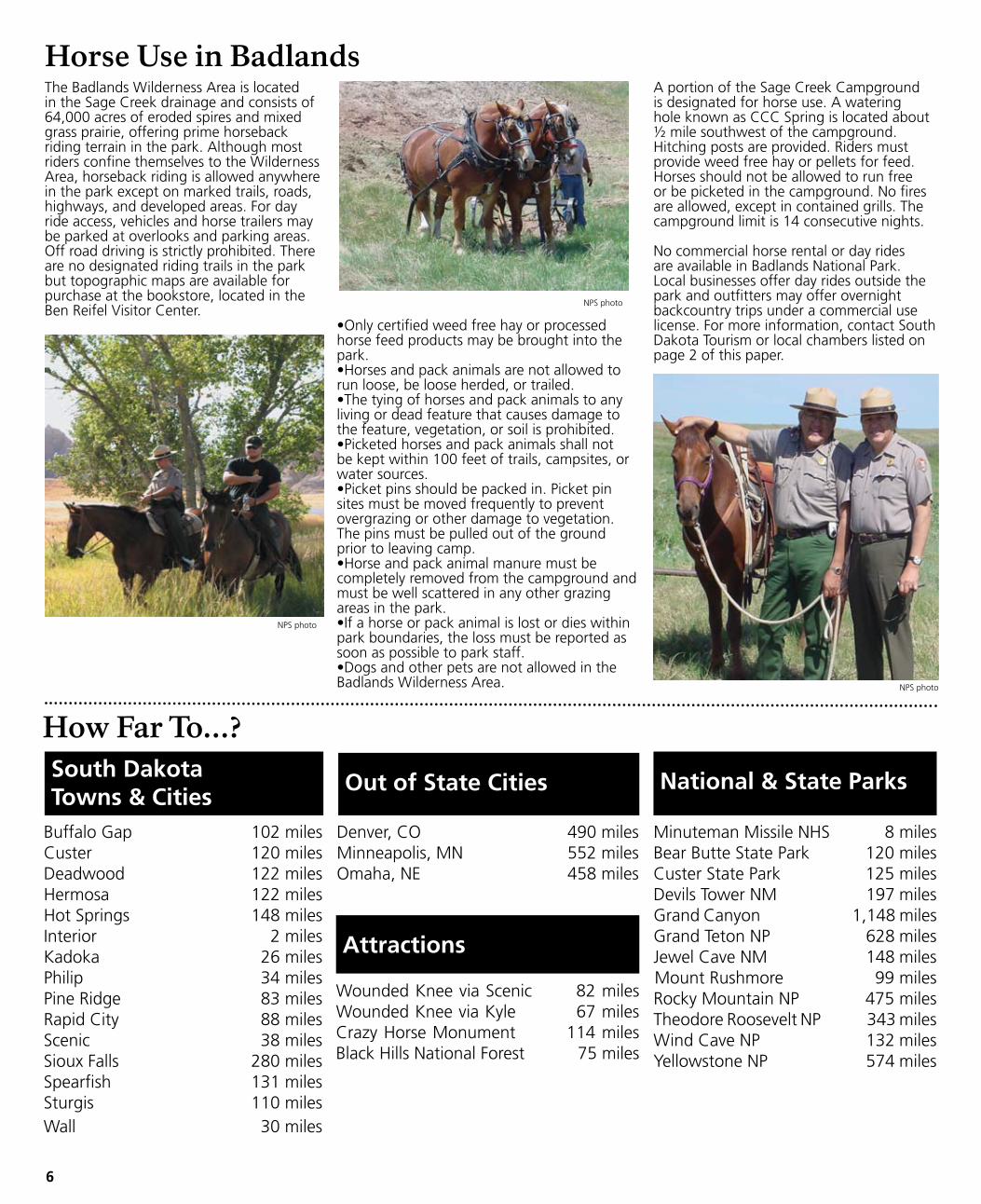
Badlands Wildlife
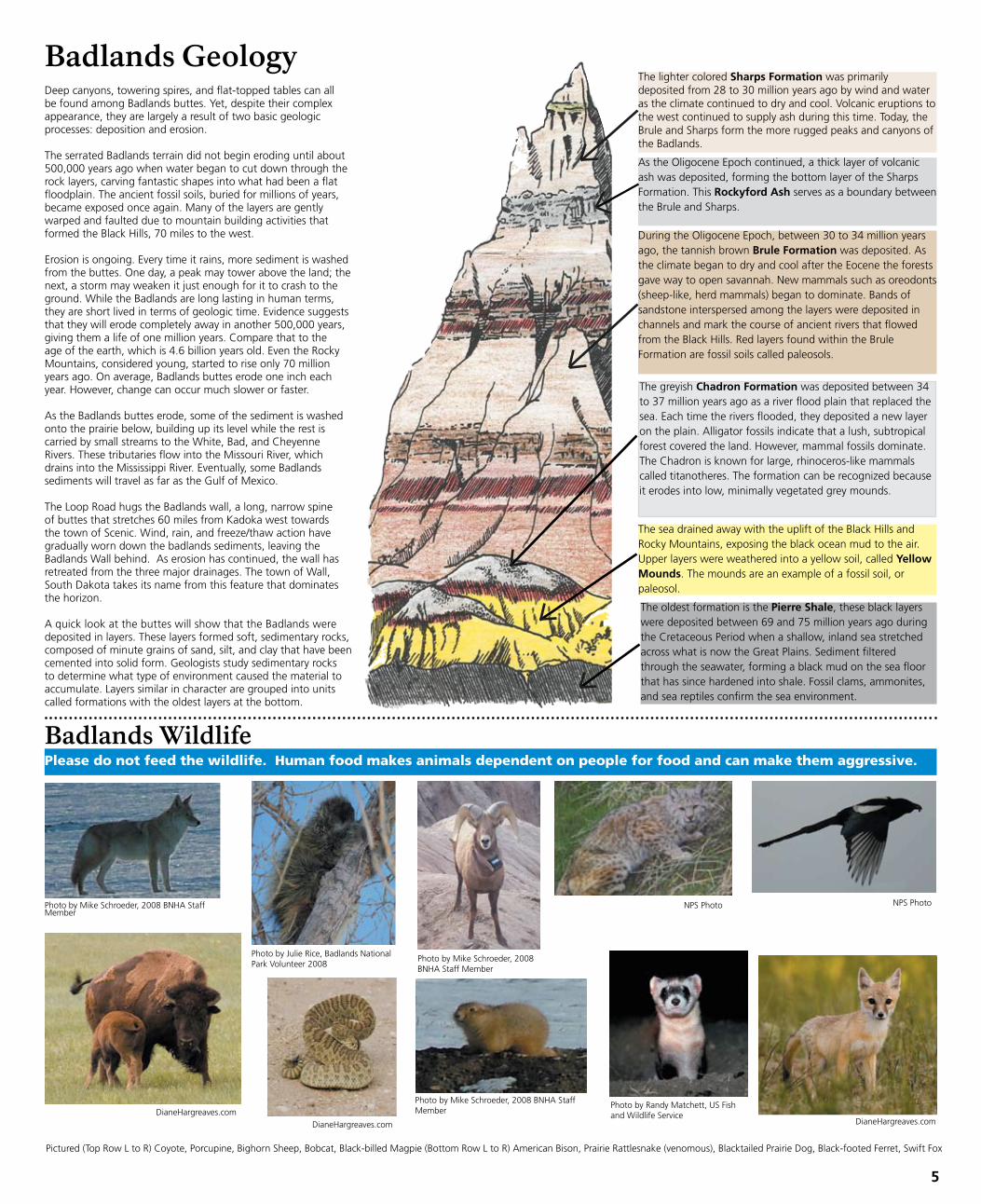
The greyish Chadron Formation was deposited between 34 to 37 million years ago as a river flood plain that replaced the sea. Each time the rivers flooded, they deposited a new layer on the plain. Alligator fossils indicate that a lush, subtropical forest covered the land. However, mammal fossils dominate. The Chadron is known for large, rhinoceros-like mammals called titanotheres. The formation can be recognized because it erodes into low, minimally vegetated grey mounds.
The oldest formation is the Pierre Shale, these black layers were deposited between 69 and 75 million years ago during the Cretaceous Period when a shallow, inland sea stretched across what is now the Great Plains. Sediment filtered through the seawater, forming a black mud on the sea floor that has since hardened into shale. Fossil clams, ammonites, and sea reptiles confirm the sea environment.
The sea drained away with the uplift of the Black Hills and Rocky Mountains, exposing the black ocean mud to the air. upper layers were weathered into a yellow soil, called Yellow Mounds. The mounds are an example of a fossil soil, or paleosol.
Deep canyons, towering spires, and flat-topped tables can all be found among Badlands buttes. Yet, despite their complex appearance, they are largely a result of two basic geologic processes: deposition and erosion. The serrated Badlands terrain did not begin eroding until about 500,000 years ago when water began to cut down through the rock layers, carving fantastic shapes into what had been a flat floodplain. The ancient fossil soils, buried for millions of years, became exposed once again. Many of the layers are gently warped and faulted due to mountain building activities that formed the Black Hills, 70 miles to the west.
Erosion is ongoing. Every time it rains, more sediment is washed from the buttes. One day, a peak may tower above the land; the next, a storm may weaken it just enough for it to crash to the ground. While the Badlands are long lasting in human terms, they are short lived in terms of geologic time. Evidence suggests that they will erode completely away in another 500,000 years, giving them a life of one million years. Compare that to the age of the earth, which is 4.6 billion years old. Even the Rocky Mountains, considered young, started to rise only 70 million years ago. On average, Badlands buttes erode one inch each year. However, change can occur much slower or faster. As the Badlands buttes erode, some of the sediment is washed onto the prairie below, building up its level while the rest is carried by small streams to the White, Bad, and Cheyenne Rivers. These tributaries flow into the Missouri River, which drains into the Mississippi River. Eventually, some Badlands sediments will travel as far as the Gulf of Mexico.
The Loop Road hugs the Badlands wall, a long, narrow spine of buttes that stretches 60 miles from Kadoka west towards the town of Scenic. Wind, rain, and freeze/thaw action have gradually worn down the badlands sediments, leaving the Badlands Wall behind. As erosion has continued, the wall has retreated from the three major drainages. The town of Wall, South Dakota takes its name from this feature that dominates the horizon. A quick look at the buttes will show that the Badlands were deposited in layers. These layers formed soft, sedimentary rocks, composed of minute grains of sand, silt, and clay that have been cemented into solid form. Geologists study sedimentary rocks to determine what type of environment caused the material to accumulate. Layers similar in character are grouped into units called formations with the oldest layers at the bottom.
Badlands Geology
During the Oligocene Epoch, between 30 to 34 million years ago, the tannish brown Brule Formation was deposited. As the climate began to dry and cool after the Eocene the forests gave way to open savannah. New mammals such as oreodonts (sheep-like, herd mammals) began to dominate. Bands of sandstone interspersed among the layers were deposited in channels and mark the course of ancient rivers that flowed from the Black Hills. Red layers found within the Brule Formation are fossil soils called paleosols.
As the Oligocene Epoch continued, a thick layer of volcanic ash was deposited, forming the bottom layer of the Sharps Formation. This Rockyford Ash serves as a boundary between the Brule and Sharps.
The lighter colored Sharps Formation was primarily deposited from 28 to 30 million years ago by wind and water as the climate continued to dry and cool. Volcanic eruptions to the west continued to supply ash during this time. Today, the Brule and Sharps form the more rugged peaks and canyons of the Badlands.
5
Pictured (Top Row L to R) Coyote, Porcupine, Bighorn Sheep, Bobcat, Black-billed Magpie (Bottom Row L to R) American Bison, Prairie Rattlesnake (venomous), Blacktailed Prairie Dog, Black-footed Ferret, Swift Fox
Photo by Mike Schroeder, 2008 BNHA Staff Member
NPS PhotoPhoto by Mike Schroeder, 2008 BNHA Staff Member
Photo by Mike Schroeder, 2008 BNHA Staff Member
NPS Photo
DianeHargreaves.comDianeHargreaves.com
DianeHargreaves.com
Photo by Julie Rice, Badlands National Park Volunteer 2008
Please do not feed the wildlife. Human food makes animals dependent on people for food and can make them aggressive.
Photo by Randy Matchett, uS Fish and Wildlife Service
41
2
2
2
2
33
27
27
40
44
44
44
44
590
502
509
590
589
240
240
377
14
90
90
9
01
Mile
01
Kilom
eter
5
5
No
r th
Wh
iteR
iverV
isitor
Cen
ter(o
pen
season
ally)
Ben
Reifel
Visito
rC
enter
(ParkH
eadq
uarters)
PINE
RID
GE
IND
IAN
RESER
VA
TION
8mi
13km
16mi
25.5km
15mi
24km
20mi
32km
14mi
22km
5mi
7.5km
23mi
37km
13.5mi
22km
5mi
7.5km2m
i3km
8.5mi
13. 5km
10mi
16km
9mi
15km
3mi
5km
19mi
30km
8.5mi
13.5km
12mi
19km
2.5mi
3.5km
20mi
32km
15mi
24km
20mi
32km
4mi
6.5km
No
r the
astE
ntr a
nce
Pinn
acles
En
t ran
ce
Inte
r ior
En
t ran
ce
Badlands
Loo
p
SeeCedar
Passdetail
map
BA
DLA
ND
SN
ATIO
NA
LP
AR
K
BA
DLA
ND
SW
ILDE
RN
ES
SA
RE
A
NO
RTH
UN
ITN
OR
THU
NIT
STR
ON
GH
OLD
UN
IT(w
ithin
Pine
Rid
ge
Ind
ianR
eservation
)
PA
LME
RC
RE
EK
UN
IT(w
ithin
Pine
Rid
ge
Ind
ianR
eservation
)
BA
DLA
ND
SN
ATIO
NA
LP
AR
K
MedicineRootCreek
Bear-in-the-LodgeCreek
PotatoCreek
Cain
Creek
PalmerCreek
CedarCreek
FrenchCreek
BattleCreek
Rapid
Creek
BearCreek
BeaverCreek
Sage
SouthFork
Middle
Fork
Spring
Creek
Cottonwood
Creek
White
Riv
White
Riv
Cheyenne
Cheyenne
White
R i
Battle
Creek
PorcupineCreek
WoundedKnee
Creek
BU
FFALO
GA
PN
ATIO
NA
LG
RA
SSLAN
D
BU
FFALO
GA
PN
ATIO
NA
LG
RA
SSLAN
D
BU
FFALO
GA
PN
ATIO
NA
LG
RA
SSLAN
D
CactusFla t
Ha
yB
utte
Ov
er lo
ok
Sa
ge
Cre
ekB
asin
Ov
er lo
ok
Ba
dla
nd
sW
i lde
rne
ssO
ver lo
ok
Re
dSh
i r tTa
ble
Ov
er lo
ok
Pin
na
clesO
ve
r loo
k
Pra
i r ieW
ind
Ov
er lo
ok
Ye
l low
Mo
un
ds
Ov
er lo
ok
Bu
rns
Ba
sinO
ver lo
ok
Wh
iteR
iv er
Va
l ley
Ove
r loo
k
Pa
no
ram
aP
oin
t
Co
na
taB
as in
Ov
er lo
ok
Ho
me
stea
dO
ve
r loo
k
An
cien
tH
un
ters
Ov
er lo
ok
Cottonwood
Wall
Exit131
Exit110
Ex it116
Ex it127
Quinn
Farmingdale
SharpsCorner
Scenic
Kyle
PotatoCreek
Interior
RedShirt
Ced
arB
utte
2443f t745m
Ce
da
rP
ass
Lod
ge
(openseasonally )
Big
Ba
dla
nd
sO
ve
r loo
k
Pr a
i r ieH
om
este
ad
Co
nata
Big
foo
tP
ass
Ov
er lo
ok
Foss i l
Ex
hib
i tTra
i l
ToR
apid
City
ToH
ermo
sa
ToM
artin
CU
NY
TABLE
ToW
oun
ded
Kn
ee
ToO
gla la
ToW
oun
ded
Kn
ee
ToW
anb
lee
ToK
ado
ka
ToB
uffalo
Gap
and
Ho
tSp
ring
s
3247ft990m
RobertsPra irie
Dog
Town
SageCreek
Road
ConataRoad
Dillo
nPass
Bigfo
otPass
Medicine
RootTra il
Sag
eC
r ee
kn
ow
ater
3282f t1000
m
SHEEPMTNTABLE
GALIGOTABLE
STRONGHOLDTABLE
BLINDMANTABLE
REDSHIRTTABLE
PLENTYSTARTABLE
CO
NA
TABA
SINCastle
Trail
Sag
e
Creek
Ri
SageCreek
Road
ForestService, U
.S. Departm
entof
Agriculture
TheG
rasslandis
interspersedw
ithpr iva tely-ow
nedland.
Checkat
theG
rasslandheadquarters
inW
all fordetails.
Unpaved
road(m
aybe
impassable
when
wet)
Unpaved
road(high-clearancevehicles
only)
Wilderness
area
Trail
Overlook
Rangerstation
Picnicarea
Restrooms
Self-guidingtrail
Campground
Primitive
campground
QUINN
TABLE
The Badlands Wilderness Area is located in the Sage Creek drainage and consists of 64,000 acres of eroded spires and mixed grass prairie, offering prime horseback riding terrain in the park. Although most riders confine themselves to the Wilderness Area, horseback riding is allowed anywhere in the park except on marked trails, roads, highways, and developed areas. For day ride access, vehicles and horse trailers may be parked at overlooks and parking areas. Off road driving is strictly prohibited. There are no designated riding trails in the park but topographic maps are available for purchase at the bookstore, located in the Ben Reifel Visitor Center.
Horse Use in Badlands
How Far To...?
A portion of the Sage Creek Campground is designated for horse use. A watering hole known as CCC Spring is located about ½ mile southwest of the campground. Hitching posts are provided. Riders must provide weed free hay or pellets for feed. Horses should not be allowed to run free or be picketed in the campground. No fires are allowed, except in contained grills. The campground limit is 14 consecutive nights.
No commercial horse rental or day rides are available in Badlands National Park. Local businesses offer day rides outside the park and outfitters may offer overnight backcountry trips under a commercial use license. For more information, contact South Dakota Tourism or local chambers listed on page 2 of this paper.
6
South Dakota Towns & Cities
Denver, CO 490 milesMinneapolis, MN 552 milesOmaha, NE 458 miles
Out of State Cities National & State Parks
Minuteman Missile NHS 8 milesBear Butte State Park 120 milesCuster State Park 125 milesDevils Tower NM 197 milesGrand Canyon 1,148 miles Grand Teton NP 628 milesJewel Cave NM 148 milesMount Rushmore 99 milesRocky Mountain NP 475 milesTheodore Roosevelt NP 343 milesWind Cave NP 132 milesYellowstone NP 574 miles
Attractions
Wounded Knee via Scenic 82 milesWounded Knee via Kyle 67 milesCrazy Horse Monument 114 milesBlack Hills National Forest 75 miles
Buffalo Gap 102 milesCuster 120 milesDeadwood 122 milesHermosa 122 milesHot Springs 148 milesInterior 2 milesKadoka 26 milesPhilip 34 milesPine Ridge 83 milesRapid City 88 milesScenic 38 milesSioux Falls 280 milesSpearfish 131 milesSturgis 110 milesWall 30 miles
•Only certified weed free hay or processed horse feed products may be brought into the park. •Horses and pack animals are not allowed to run loose, be loose herded, or trailed.•The tying of horses and pack animals to any living or dead feature that causes damage to the feature, vegetation, or soil is prohibited.•Picketed horses and pack animals shall not be kept within 100 feet of trails, campsites, or water sources.•Picket pins should be packed in. Picket pin sites must be moved frequently to prevent overgrazing or other damage to vegetation. The pins must be pulled out of the ground prior to leaving camp.•Horse and pack animal manure must be completely removed from the campground and must be well scattered in any other grazing areas in the park.•If a horse or pack animal is lost or dies within park boundaries, the loss must be reported as soon as possible to park staff.•Dogs and other pets are not allowed in the Badlands Wilderness Area.
NPS photo
NPS photo
NPS photo
41
2
2
2
2
33
27
27
40
44
44
44
44
590
502
509
590
589
240
240
377
14
90
90
9
01
Mile
01
Kilom
eter
5
5
No
r th
Wh
iteR
iverV
isitor
Cen
ter(o
pen
season
ally)
Ben
Reifel
Visito
rC
enter
(ParkH
eadq
uarters)
PINE
RID
GE
IND
IAN
RESER
VA
TION
8mi
13km
16mi
25.5km
15mi
24km
20mi
32km
14mi
22km
5mi
7.5km
23mi
37km
13.5mi
22km
5mi
7.5km2m
i3km
8.5mi
13.5km
10mi
16km
9mi
15km
3mi
5km
19mi
30km
8.5mi
13.5km
12mi
19km
2.5mi
3.5km
20mi
32km
15mi
24km
20mi
32km
4mi
6.5km
No
r the
ast
En
tran
ce
Pinn
acles
En
tran
ce
Inte
r ior
En
t ran
ce
Badlands
Loo
p
SeeCedar
Passdetail
map
BA
DLA
ND
SN
ATIO
NA
LP
AR
K
BA
DLA
ND
SW
ILDE
RN
ES
SA
RE
A
NO
RTH
UN
ITN
OR
THU
NIT
STR
ON
GH
OLD
UN
IT(w
ithin
Pine
Rid
ge
Ind
ianR
eservation
)
PA
LME
RC
RE
EK
UN
IT(w
ithin
Pine
Rid
ge
Ind
ianR
eservation
)
BA
DLA
ND
SN
ATIO
NA
LP
AR
K
MedicineRootCreek
Bear-in-the-LodgeCreek
PotatoCreek
Cain
Creek
PalmerCreek
CedarCreek
FrenchCreek
BattleCreek
Rapid
Creek
BearCreek
BeaverCreek
Sage
SouthFork
Middle
Fork
Spring
Creek
Cottonwood
Creek
White
Riv
White
Riv
Cheyenne
Cheyenne
White
R i
Battle
Creek
PorcupineCreek
WoundedKnee
Creek
BU
FFALO
GA
PN
ATIO
NA
LG
RA
SSLAN
D
BU
FFALO
GA
PN
ATIO
NA
LG
RA
SSLAN
D
BU
FFALO
GA
PN
ATIO
NA
LG
RA
SSLAN
D
CactusFlat
Ha
yB
utte
Ov
er lo
ok
Sa
ge
Cre
ekB
as in
Ov
erlo
ok
Ba
dla
nd
sW
ilde
rne
ssO
ver lo
ok
Re
dSh
ir tTa
ble
Ov
er lo
ok
Pin
na
clesO
ve
r loo
k
Pra
ir ieW
ind
Ov
er lo
ok
Ye
llow
Mo
un
ds
Ov
er lo
ok
Bu
rns
Ba
sinO
ver lo
ok
Wh
iteR
iver
Va
l ley
Ove
r loo
k
Pa
no
ram
aP
oin
t
Co
na
taB
asin
Ov
er lo
ok
Ho
me
stea
dO
ve
r loo
k
An
cien
tH
un
ter s
Ov
er lo
ok
Cottonwood
Wall
Exit131
Exit110
Exit116
Exit127
Quinn
Farmingdale
SharpsCorner
Scenic
Kyle
PotatoCreek
Interior
RedShirt
Ced
arB
utte
2443ft745m
Ce
da
rP
ass
Lod
ge
(openseasonally)
Big
Ba
dla
nd
sO
ve
rloo
k
Pra
i r ieH
om
este
ad
Co
nata
Big
f oo
tP
ass
Ov
er lo
ok
Foss i l
Ex
hib
i tTr a
i l
ToR
apid
City
ToH
ermo
sa
ToM
artin
CU
NY
TABLE
ToW
oun
ded
Kn
ee
ToO
glala
ToW
oun
ded
Kn
ee
ToW
anb
lee
ToK
ado
ka
ToB
uffalo
Gap
and
Ho
tSp
rings
3247f t990m
RobertsPrairie
Dog
Town
SageCreek
Road
ConataRoad
Dillo
nPass
Bigfo
otPass
Medicine
RootTrail
Sag
eC
reek
no
water
3282ft1000
m
SHEEPMTNTABLE
GALIGOTABLE
STRONGHOLDTABLE
BLINDMANTABLE
REDSHIRTTABLE
PLENTYSTARTABLE
CO
NA
TABA
SINCastle
Trail
Sag
e
Creek
Ri
SageCreek
Road
ForestService, U
.S. Departm
entof
Agriculture
TheG
rasslandis
interspersedw
ithprivately-ow
nedland.
Checkat
theG
rasslandheadquarters
inW
all fordetails.
Unpaved
road(m
aybe
impassable
when
wet)
Unpaved
road(high-clearancevehicles
only)
Wilderness
area
Trail
Overlook
Rangerstation
Picnicarea
Restrooms
Self-guidingtrail
Campground
Primitive
campground
QUINN
TABLE
Restau
rant
Pay ph
on
e
Wild
life or scen
ic viewin
g area
Recyclin
g co
ntain
ers
Info
rmatio
nD
rinkin
g w
ater available
First Aid
Han
dicap
ped
accessible
Lod
gin
g
Do
or an
d W
ind
ow
Trailhead
Bo
oksto
re
Park Map
7
Ran
ger Pro
gram
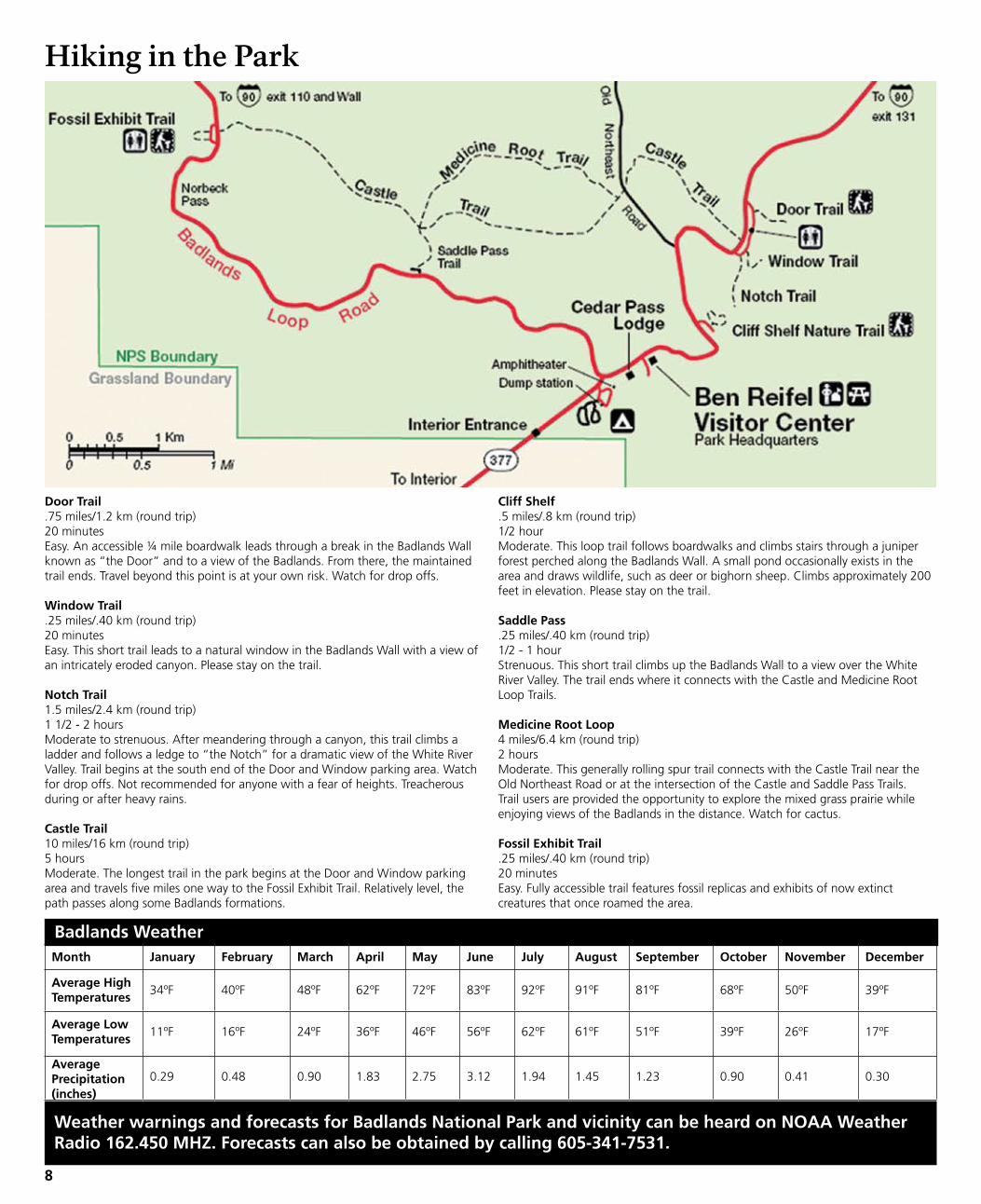
Door Trail.75 miles/1.2 km (round trip)20 minutesEasy. An accessible ¼ mile boardwalk leads through a break in the Badlands Wall known as “the Door” and to a view of the Badlands. From there, the maintained trail ends. Travel beyond this point is at your own risk. Watch for drop offs.
Window Trail.25 miles/.40 km (round trip)20 minutesEasy. This short trail leads to a natural window in the Badlands Wall with a view of an intricately eroded canyon. Please stay on the trail.
Notch Trail1.5 miles/2.4 km (round trip)1 1/2 - 2 hoursModerate to strenuous. After meandering through a canyon, this trail climbs a ladder and follows a ledge to “the Notch” for a dramatic view of the White River Valley. Trail begins at the south end of the Door and Window parking area. Watch for drop offs. Not recommended for anyone with a fear of heights. Treacherous during or after heavy rains.
Castle Trail10 miles/16 km (round trip)5 hoursModerate. The longest trail in the park begins at the Door and Window parking area and travels five miles one way to the Fossil Exhibit Trail. Relatively level, the path passes along some Badlands formations.
Cliff Shelf.5 miles/.8 km (round trip)1/2 hourModerate. This loop trail follows boardwalks and climbs stairs through a juniper forest perched along the Badlands Wall. A small pond occasionally exists in the area and draws wildlife, such as deer or bighorn sheep. Climbs approximately 200 feet in elevation. Please stay on the trail.
Saddle Pass.25 miles/.40 km (round trip)1/2 - 1 hourStrenuous. This short trail climbs up the Badlands Wall to a view over the White River Valley. The trail ends where it connects with the Castle and Medicine Root Loop Trails.
Medicine Root Loop4 miles/6.4 km (round trip)2 hoursModerate. This generally rolling spur trail connects with the Castle Trail near the Old Northeast Road or at the intersection of the Castle and Saddle Pass Trails. Trail users are provided the opportunity to explore the mixed grass prairie while enjoying views of the Badlands in the distance. Watch for cactus.
Fossil Exhibit Trail.25 miles/.40 km (round trip)20 minutesEasy. Fully accessible trail features fossil replicas and exhibits of now extinct creatures that once roamed the area.
Hiking in the Park
Badlands Weather
Weather warnings and forecasts for Badlands National Park and vicinity can be heard on NOAA Weather Radio 162.450 MHZ. Forecasts can also be obtained by calling 605-341-7531.
Month January February March April May June July August September October November December
Average High Temperatures
34ºF 40ºF 48ºF 62ºF 72ºF 83ºF 92ºF 91ºF 81ºF 68ºF 50ºF 39ºF
Average Low Temperatures
11ºF 16ºF 24ºF 36ºF 46ºF 56ºF 62ºF 61ºF 51ºF 39ºF 26ºF 17ºF
Average Precipitation (inches)
0.29 0.48 0.90 1.83 2.75 3.12 1.94 1.45 1.23 0.90 0.41 0.30
8

The Badlands Natural History Association, or BNHA, was established in 1959 to work in cooperation with the National Park Service in furthering its scientific, educational, historical and interpretive activities. Since then, BNHA has contributed over $1 million to the park. Sales of BNHA items in the park visitor center results in donations to the park’s education and resource management programs.
BNHA is a nonprofit organization that has an active membership program. To become a member of BNHA, complete the membership form and submit with payment of dues at the Ben Reifel Visitor Center or mail to BNHA; P.O. Box 47; Interior, South Dakota 57750. Members receive a 15% discount on all sales of BNHA merchandise and will receive a discount at most other National Park Service bookstores.
Your membership dues are used directly to enhance the experience of visitors to the area. An investment for the future, your contribution is a perpetuation of the National Park idea.
Your membership dues will be gratefully received, immediately acknowledged, and efficiently used. Your membership dues are tax-deductible.
Individual Association Membership $25 per person per calendar year. Includes membership card allowing you a 15% discount at BNHA stores and discounts with other cooperating associations in the U.S. and special mailings through the year.
Lifetime Membership $250 per person.
Includes membership card allowing you a 15% discount at BNHA stores and discounts with other cooperating associations in the U.S. and special mailings.
Name
Address
City State Zip Phone Amount Enclosed
Shop Badlands Natural History Association
Badlands Its Life and LandscapeAuthor: Joy Keve Hauk$7.95 **
Packed with information on geology, paleontology, human history, flora, and fauna, this booklet has numerous identifying photos.
Join Badlands Natural History Association
A Revelation Called the Badlands Building a National Park 1909 – 1939$4.95 **Author: Jay Shuler
The National Park Service and South Dakota State archives provided the photos and history of the struggle to protect the White River Badlands as a national park.
Badlands Suite$19.99 **DVD includes: Land of Stone and LightFrom Field to LabMultiple Perspectives
This DVD takes you on a journey into the White River Badlands of South Dakota. In three different presentations, become acquainted with the people of this place.
Wildflowers, Grasses, & Other Plants of the Northern Plains and Black HillsAuthor: Theodore Van Bruggen$8.95 **
Color photographs and descriptions of over 300 plants found in Badlands National Park and the surrounding areas.
The Hole StoryAuthor: Sally Plumb$6.95 **
Wonderful illustrations accompany this children’s story of life on the prairie. Learn about Kit, an endangered black-footed ferret, and his struggle to survive when he gets reintroduced to the wild in Badlands National Park.
**All prices are subject to change.
9
Legends of the Mighty Sioux
$7.95**
A compilation of forty-five legends of the famous Sioux Indians of South Dakota. All of the legends pertain to the Sioux’ traditional lore, from tales told around the campfire, to legends associated with places or mountains, and battle and hunting legends.
The White River BadlandsAuthor: Cleophas C. O’Harra Ph.D., LL. D., President and Professor of Geology $9.95 **
This is the only book in print specifically about the geology and paleontology of the White River Badlands of South Dakota at present.
NPS Photo
NPS Photo
Check out the new Badlands Natural History Association website: www.badlandsnha.org.
NPS Photo
Badlands National Park is a designated Federal Recreation Fee Area. Fees collected at Badlands directly benefit this park and other units of the National Park Service. Fees paid at Badlands are unique in that under special agreement fees are split with the Oglala Sioux Tribe.
Some of the projects that have been funded by fees at Badlands include:
•upgraded comfort stations in the Cedar Pass Campground•Park-wide trail improvements•New exhibits and park film at the Ben Reifel Visitor Center
Become a Junior Ranger!
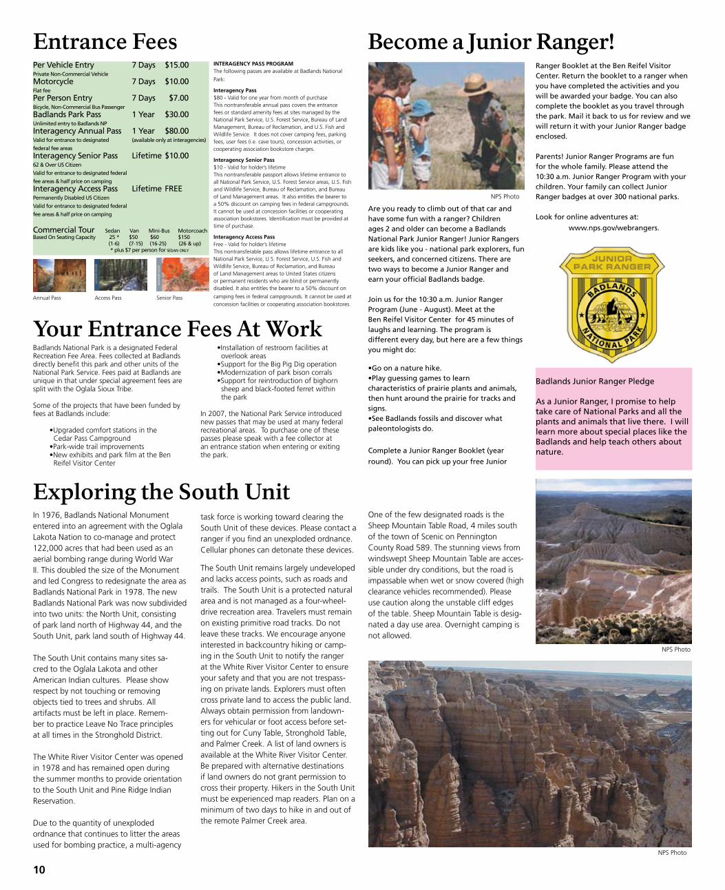
Are you ready to climb out of that car and have some fun with a ranger? Children ages 2 and older can become a Badlands National Park Junior Ranger! Junior Rangers are kids like you - national park explorers, fun seekers, and concerned citizens. There are two ways to become a Junior Ranger and earn your official Badlands badge.
Join us for the 10:30 a.m. Junior Ranger Program (June - August). Meet at the Ben Reifel Visitor Center for 45 minutes of laughs and learning. The program is different every day, but here are a few things you might do:
•Go on a nature hike.•Play guessing games to learn characteristics of prairie plants and animals, then hunt around the prairie for tracks and signs.•See Badlands fossils and discover what paleontologists do.
Complete a Junior Ranger Booklet (year
round). You can pick up your free Junior
Badlands Junior Ranger Pledge
As a Junior Ranger, I promise to help take care of National Parks and all the plants and animals that live there. I will learn more about special places like the Badlands and help teach others about nature.
Ranger Booklet at the Ben Reifel Visitor Center. Return the booklet to a ranger when you have completed the activities and you will be awarded your badge. You can also complete the booklet as you travel through the park. Mail it back to us for review and we will return it with your Junior Ranger badge enclosed.
Parents! Junior Ranger Programs are fun for the whole family. Please attend the 10:30 a.m. Junior Ranger Program with your children. Your family can collect Junior Ranger badges at over 300 national parks.
Look for online adventures at:
www.nps.gov/webrangers.
In 1976, Badlands National Monument entered into an agreement with the Oglala Lakota Nation to co-manage and protect 122,000 acres that had been used as an aerial bombing range during World War II. This doubled the size of the Monument and led Congress to redesignate the area as Badlands National Park in 1978. The new Badlands National Park was now subdivided into two units: the North unit, consisting of park land north of Highway 44, and the South unit, park land south of Highway 44.
The South unit contains many sites sa-cred to the Oglala Lakota and other American Indian cultures. Please show respect by not touching or removing objects tied to trees and shrubs. All artifacts must be left in place. Remem-ber to practice Leave No Trace principles at all times in the Stronghold District. The White River Visitor Center was opened in 1978 and has remained open during the summer months to provide orientation to the South unit and Pine Ridge Indian Reservation.
Due to the quantity of unexploded ordnance that continues to litter the areas used for bombing practice, a multi-agency
The South unit remains largely undeveloped and lacks access points, such as roads and trails. The South unit is a protected natural area and is not managed as a four-wheel-drive recreation area. Travelers must remain on existing primitive road tracks. Do not leave these tracks. We encourage anyone interested in backcountry hiking or camp-ing in the South unit to notify the ranger at the White River Visitor Center to ensure your safety and that you are not trespass-ing on private lands. Explorers must often cross private land to access the public land. Always obtain permission from landown-ers for vehicular or foot access before set-ting out for Cuny Table, Stronghold Table, and Palmer Creek. A list of land owners is available at the White River Visitor Center. Be prepared with alternative destinations if land owners do not grant permission to cross their property. Hikers in the South unit must be experienced map readers. Plan on a minimum of two days to hike in and out of the remote Palmer Creek area.
Exploring the South UnitOne of the few designated roads is the Sheep Mountain Table Road, 4 miles south of the town of Scenic on Pennington County Road 589. The stunning views from windswept Sheep Mountain Table are acces-sible under dry conditions, but the road is impassable when wet or snow covered (high clearance vehicles recommended). Please use caution along the unstable cliff edges of the table. Sheep Mountain Table is desig-nated a day use area. Overnight camping is not allowed.
10
task force is working toward clearing the South unit of these devices. Please contact a ranger if you find an unexploded ordnance. Cellular phones can detonate these devices.
Your Entrance Fees At Work•Installation of restroom facilities at overlook areas•Support for the Big Pig Dig operation•Modernization of park bison corrals•Support for reintroduction of bighorn sheep and black-footed ferret within the park
In 2007, the National Park Service introduced new passes that may be used at many federal recreational areas. To purchase one of these passes please speak with a fee collector at an entrance station when entering or exiting the park.
Entrance FeesPer Vehicle Entry 7 Days $15.00Private Non-Commercial Vehicle
Motorcycle 7 Days $10.00Flat fee
Per Person Entry 7 Days $7.00Bicycle, Non-Commercial Bus Passenger
Badlands Park Pass 1 Year $30.00Unlimited entry to Badlands NP
Interagency Annual Pass 1 Year $80.00Valid for entrance to designated (available only at interagencies)
federal fee areas
Interagency Senior Pass Lifetime $10.0062 & Over US Citizen
Valid for entrance to designated federal
fee areas & half price on camping
Interagency Access Pass Lifetime FREEPermanently Disabled US Citizen
Valid for entrance to designated federal
fee areas & half price on camping
Commercial Tour Sedan Van Mini-Bus MotorcoachBased On Seating Capacity 25 * $50 $60 $150 (1-6) (7-15) (16-25) (26 & up) * plus $7 per person for sedan only
INTERAGENCY PASS PROGRAM The following passes are available at Badlands National
Park:
Interagency Pass $80 - Valid for one year from month of purchase This nontransferable annual pass covers the entrance fees or standard amenity fees at sites managed by the National Park Service, u.S. Forest Service, Bureau of Land Management, Bureau of Reclamation, and u.S. Fish and Wildlife Service. It does not cover camping fees, parking fees, user fees (i.e. cave tours), concession activities, or cooperating association bookstore charges.
Interagency Senior Pass $10 - Valid for holder’s lifetime This nontransferable passport allows lifetime entrance to all National Park Service, u.S. Forest Service areas, u.S. Fish and Wildlife Service, Bureau of Reclamation, and Bureau of Land Management areas. It also entitles the bearer to a 50% discount on camping fees in federal campgrounds. It cannot be used at concession facilities or cooperating association bookstores. Identification must be provided at time of purchase.
Interagency Access Pass Free - Valid for holder’s lifetime This nontransferable pass allows lifetime entrance to all National Park Service, u.S. Forest Service, u.S. Fish and Wildlife Service, Bureau of Reclamation, and Bureau of Land Management areas to united States citizens or permanent residents who are blind or permanently disabled. It also entitles the bearer to a 50% discount on
camping fees in federal campgrounds. It cannot be used at concession facilities or cooperating
association bookstores.
Annual Pass Senior PassAccess Pass
NPS Photo
NPS Photo
NPS Photo
Minuteman Missile
You Have Questions – We Have the “Top Secret” Answers
National Park ServiceU.S. Department of the Interior
National Historic SiteSouth Dakota
How do I get to Minuteman Missile National Historic Site?The Minuteman Missile Visitor Contact Station is a great starting point for tours to the site and where you can view the park film. It is located off Interstate 90, exit 131, beside the Badlands Trading Post (Conoco gas station). To get there from the Badlands National Park Visitor Center, take South Dakota Highway 240 8.5 miles north towards Interstate 90. Just before reaching the interstate you will see the Badlands Trading Post on the left. The Visitor Contact Station is adjacent to the trading post.
What are the hours for the Minuteman Missile Visitor Contact Station? The contact station is open from 8:00 a.m. to 4:30 p.m., Monday through Saturday and closed on Sunday during the Summer season (Memorial Day - Labor Day). The rest of the year, the contact station is open Monday through Friday from 8:00 a.m. to 4:30 p.m..
Can we see the missile silo?Launch Facility Delta-09 (the missile silo) is open from Monday through Saturday May 1st - October 31 from 8:00 - 4:00 p.m. with no reservations required. A ranger will be stationed on site intermittently to provide informal programs and answer questions. When a ranger is not at the silo, a self-guided cell phone tour is available to guide your visit to the launch facility (missile silo) Delta-09. Visitors can access up to ten tour stops via their own cell phone. These stops offer information about the silo structures and operations during the Cold War. Delta-09 is located on the south side of Interstate 90, exit 116. Turn south on to the county road and the silo is ½ mile on the right.
What else can we see at Minuteman Missile?Open Houses are given every Thursday throughout the summer from 9:00 a.m. - Noon. Reservations are not required! Visitors will be able to get an abbreviated ranger guided tour of Launch Control Facility Delta-01. This tour will include the opportunity to go into the underground Launch Control Center and learn how Minuteman nuclear missiles could have been launched during the Cold War.
Formal tours require a reservation. They are offered Monday through Friday during the summer. Tour space, except for open house days, is extremely limited; it is best to make reservations in advance by calling 605-433-5552. Tours are also given once a day, Monday through Friday from November 1st - April 30th at 10:00 a.m.
Got Kids? Get A Patch!Come to the Minuteman Missile Visitor Contact Station to get a Junior Ranger Program. We have programs for kids 7-11 years of age and 12 and up! When they successfully complete the program, a National Park Service ranger will issue an official certificate and a Junior Missileer patch!
11
NPS Photo
NPS Photo
NPS Photo
“Ace In The Hole”President Kennedy referring to Minuteman Missiles, 1962
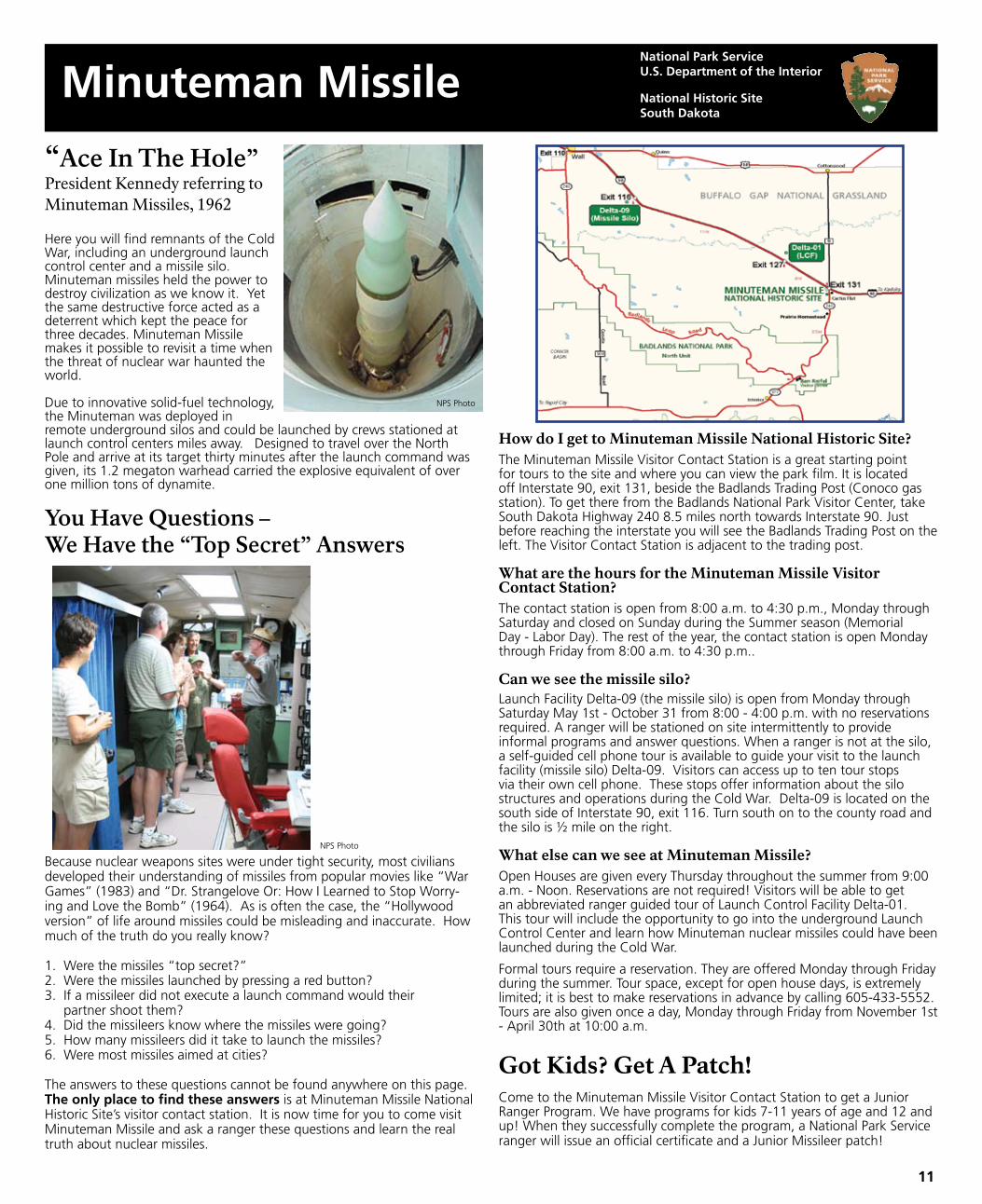
Here you will find remnants of the ColdWar, including an underground launchcontrol center and a missile silo. Minuteman missiles held the power to destroy civilization as we know it. Yet the same destructive force acted as a deterrent which kept the peace for three decades. Minuteman Missile makes it possible to revisit a time when the threat of nuclear war haunted the world.
Due to innovative solid-fuel technology, the Minuteman was deployed in remote underground silos and could be launched by crews stationed at launch control centers miles away. Designed to travel over the North Pole and arrive at its target thirty minutes after the launch command was given, its 1.2 megaton warhead carried the explosive equivalent of over one million tons of dynamite.
NPS Photo
Because nuclear weapons sites were under tight security, most civilians developed their understanding of missiles from popular movies like “War Games” (1983) and “Dr. Strangelove Or: How I Learned to Stop Worry-ing and Love the Bomb” (1964). As is often the case, the “Hollywood version” of life around missiles could be misleading and inaccurate. How much of the truth do you really know?
1. Were the missiles “top secret?”2. Were the missiles launched by pressing a red button?3. If a missileer did not execute a launch command would their partner shoot them?4. Did the missileers know where the missiles were going?5. How many missileers did it take to launch the missiles?6. Were most missiles aimed at cities?
The answers to these questions cannot be found anywhere on this page. The only place to find these answers is at Minuteman Missile National Historic Site’s visitor contact station. It is now time for you to come visit Minuteman Missile and ask a ranger these questions and learn the real truth about nuclear missiles.
Scenic Views of Badlands
Geology Walk 8:30 a.m. DailyExplore the geologic story of the White River Badlands on this 45 minute walk. Meet at the Door Trailhead located at the far north end of the Doors/Windows parking area two miles south of the Northeast Entrance Station on the Badlands Loop Road. Wear a hat and closed-toe shoes. Terrain is varied.
Fossil Talk 10:30 a.m., 1:30 p.m., 3:30 p.m. DailyExplore what fossils can tell us about the story of ancient life in the Badlands and why they should be protected at this 15 - 20 minute talk. Presented at the Fossil Exhibit Trail, 5 miles northwest of the park headquarters/visitor center on the Badlands Loop Road.
Junior Ranger Program 10:30 a.m. DailyCalling all visitors between 7 and 12 years of age! Meet at the Ben Reifel Visitor Center for a 45 minute adventure into an aspect of the Badlands. Wear closed-toe shoes and a hat. It may be a walk, a game, or another activity. Attendees will be awarded a Junior Ranger badge. Parents are also welcome!
Prairie Walk 5:30 p.m. DailyJoin a park ranger for this easy, 1/2 mile walk into the prairie. Meet at the Ben Reifel Visitor Center for an exploration of prairie life and landscape. Wear closed-toe shoes and bring a hat and water.
Night Sky Program or Evening Program 9:00 p.m. Daily (Starting August 1st, the evening program will be given at 8:30 p.m.)Join a park ranger for a 40 minute presentation at the Cedar Pass Campground Amphitheater. A weekly listing of program topics is available at the Ben Reifel Visitor Center and bulletin boards throughout the park. Program will start when the sky is dark!
Badlands National Park is in the Mountain Time Zone. Programs are presented at several locations throughout the park. These locations are identified in the park newspaper and park brochure. You can also find them by watching for white signs announcing programs along the Loop Road.
These programs run from Sunday, May 31 through Saturday, August 15, 2009 = accessible
12
Visitors: Be Alert for Construction
Ranger Programs
Stop by the Ben Reifel Visitor Center and
ask about updated program listings,
special programs, and events. These will
also be posted on the bulletin boards
throughout the park.
Badlands at night
Sunrise
Storm clouds
Lightning storm
Sunset
After a rainstorm
NPS Photo
NPS Photo
NPS Photo
NPS Photo
NPS Photo
NPS Photo
NPS PhotoNPS Photo
NPS Photo
During the summer of 2009, there will be work zones throughout the park for road construction and improve-ment, fencing projects, boardwalk and building repairs. There will be extensive foundation drainage work being performed at the Cedar Pass Lodge. This work will cause some dust, noise, and changes in foot traffic patternsin those areas.
As we go to press, the schedule for these and other activities has not been set. Please check at the entrance stations or the Ben Reifel Visitor Center and White River Visitor Center for information on closures or delays. use caution around heavy equipment. Please observe all road warnings. Do not enter areas posted as “closed.” Our goal is a safe visit for all!