vliet street redevelopment plan
DESCRIPTION
This report was prepared to address a variety of challenges facing the West Vliet Street business corridor, with the ultimate goal of fulfi lling the corridor’s potential as a regional retail and entertainment destination. These challenges include barriers to connectivity, a shortage of funding for business association activities, and a lack of a cohesive and clear neighborhood identity.TRANSCRIPT
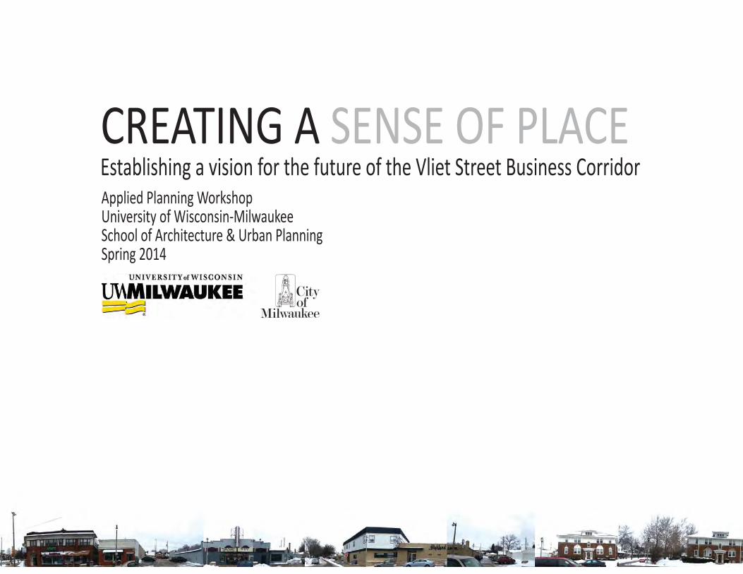
CREATING A SENSE OF PLACEEstablishing a vision for the future of the Vliet Street Business CorridorApplied Planning WorkshopUniversity of Wisconsin-MilwaukeeSchool of Architecture & Urban PlanningSpring 2014
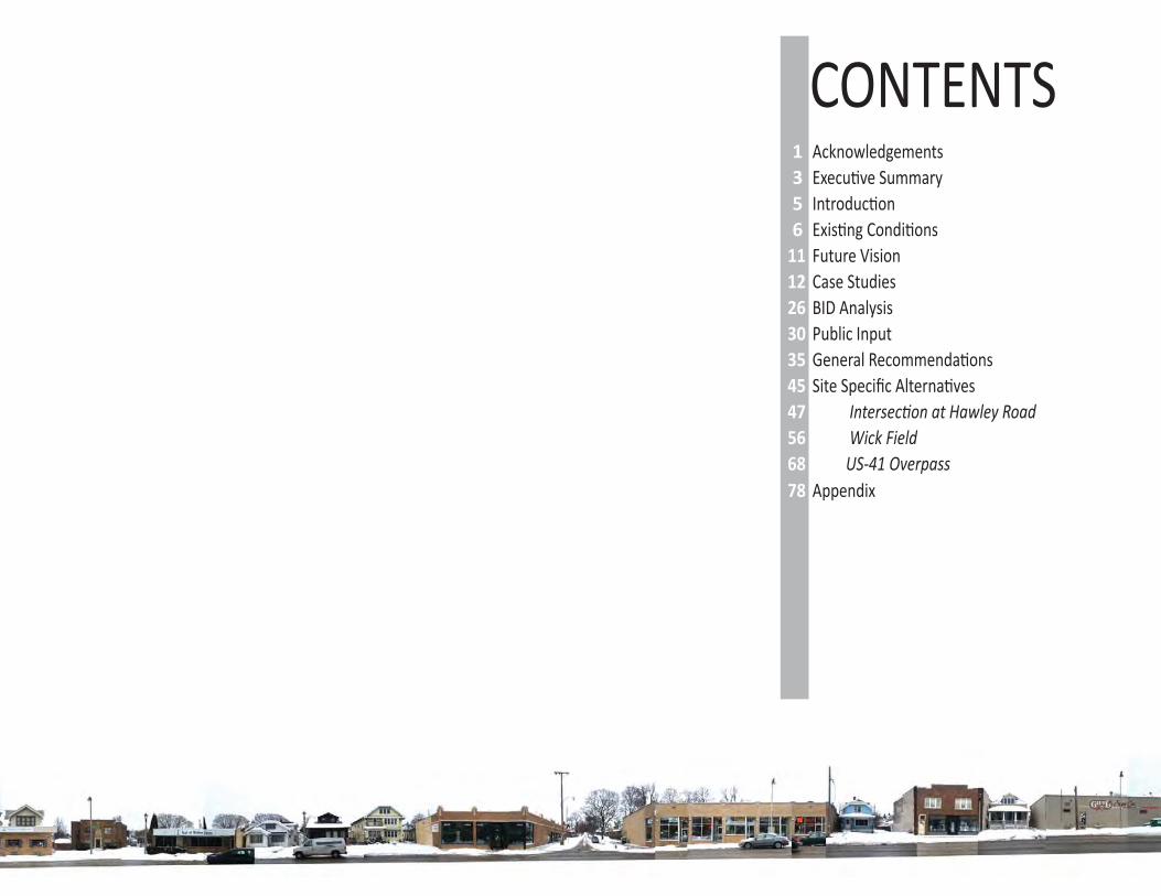
CONTENTS1 Acknowledgements3 Execu ve Summary5 Introduc on6 Exis ng Condi ons
11 Future Vision12 Case Studies26 BID Analysis30 Public Input35 General Recommenda ons45 Site Specifi c Alterna ves47 Intersec on at Hawley Road56 Wick Field68 US-41 Overpass78 Appendix
1
VLIET ST.CORRIDOR
CATALYZINGIMPROVEMENTS
Acknowledgements
Execu ve Summary
Introduc on
Exis ng Condi ons
Future Vision
Case Studies
BID Analysis
Public Input
General Recommenda ons
Site Specifi c Alterna ves
Intersec on at Hawley Road
Wick Field
US-41 Overpass
Appendix
This document was created by Mitchell Baker, Robert Lambert, Amanda Yang, Emily Purcell, and Richard VanDerWal, graduate students in the Master of Urban Planning program at the University of Wisconsin-Milwaukee during the Spring semester of 2014.
We would like to express our special apprecia on and thanks to our clients, Robert Harris and Vanessa Koster, from the City of Milwaukee’s Department of City Development, John Gietl, from the West Vliet Street Business Associa on, and Larry Kilmer, from Washington Heights Neighborhood Associa on for their guidance, feedback, and support throughout this project.
We would also like to take this opportunity to thank our professors, Nancy Frank and Carolyn Esswein, for their valuable support and guidance, which has helped us in comple ng this project throughout the various stages.
We also are apprecia ve of the stakeholders who off ered their me to be a part of our public par cipa on mee ng. We are grateful for their coopera on and informa on that they provided.
ACKNOWLEDGEMENTS
3
VLIET ST.CORRIDOR
CATALYZINGIMPROVEMENTS
Acknowledgements
Execu ve Summary
Introduc on
Exis ng Condi ons
Future Vision
Case Studies
BID Analysis
Public Input
General Recommenda ons
Site Specifi c Alterna ves
Intersec on at Hawley Road
Wick Field
US-41 Overpass
Appendix
This report was prepared to address a variety of challenges facing the West Vliet Street business corridor, with the ul mate goal of fulfi lling the corridor’s poten al as a regional retail and entertainment des na on. These challenges include barriers to connec vity, a shortage of funding for business associa on ac vi es, and a lack of a cohesive and clear neighborhood iden ty.
First, this report outlines the context and the details of these challenges. Case studies are provided as examples of how other communi es addressed parallel issues. Example cases focusing on urban design emphasized con nuity in design, infi ll development, and the crea on of public rights of way that are safe and intui ve for cyclists and pedestrians. Other examples highlight how business communi es raised revenue and determined spending for physical improvements, events, and business development. These successes provided us with a realis c framework for determining how Vliet Street can proceed.
This report iden fi es ways that Vliet Street could approach the forma on of a Business Improvement District, depending on the total funding goal and the limita ons of individual businesses. Ul mately, we propose that the BID assess member businesses at a monthly rate of $114, yielding a yearly revenue of $75,000. A wide range of op ons are available for BID funding, but we feel this rate eff ec vely balances the need to fund BID ac vi es with the limited means of the corridor’s smaller establishments.
Drawing on the case studies, likely BID funding, and public feedback, we developed design and land use recommenda ons for the corridor as a whole. Using a design concept that highlights the area’s uniqueness, neighborliness, and variety of ameni es, we recommend that the corridor develop wayfi nding signage, install iden fying features like banners, and take advantage of the area’s arts presence and space for public art installa ons. These can be accomplished in the short term at a rela vely low cost; as other funding sources become available, we propose the implementa on of traffi c calming measures, connec ve infrastructure for bicycles and pedestrians, and monumental signage at gateways into the corridor.
Within the corridor, we found opportuni es for development at a higher density and higher level of ac vity. We propose parcel redevelopments (in addi on to the above improvements) at the western end of the US-41 overpass and at the southwest corner of Vliet Street and Hawley Road. Both sites can support a small mixed-use development with on-site parking, and we suggest a variety of retail uses that could thrive in those loca ons. The US-41 overpass itself should be a priority for infrastructure upgrades and art installa ons; this report provides suggested materials and designs. Finally, we propose transforming Wick Field into a fl agship neighborhood park by establishing year-round venues such as a beer garden or cafe and temporary hockey rinks.
We are confi dent that these recommenda ons will serve to ac vate underused space within the corridor, genera ng publicity and revenue for the exis ng businesses. West Vliet Street has tremendous poten al for long term growth as a retail des na on, and even modest enhancements to the corridor’s physical environment will help bring about that vision.
EXECUTIVE SUMMARY
5
VLIET ST.CORRIDOR
CATALYZINGIMPROVEMENTS
Acknowledgements
Execu ve Summary
Introduc on
Exis ng Condi ons
Future Vision
Case Studies
BID Analysis
Public Input
General Recommenda ons
Site Specifi c Alterna ves
Intersec on at Hawley Road
Wick Field
US-41 Overpass
Appendix
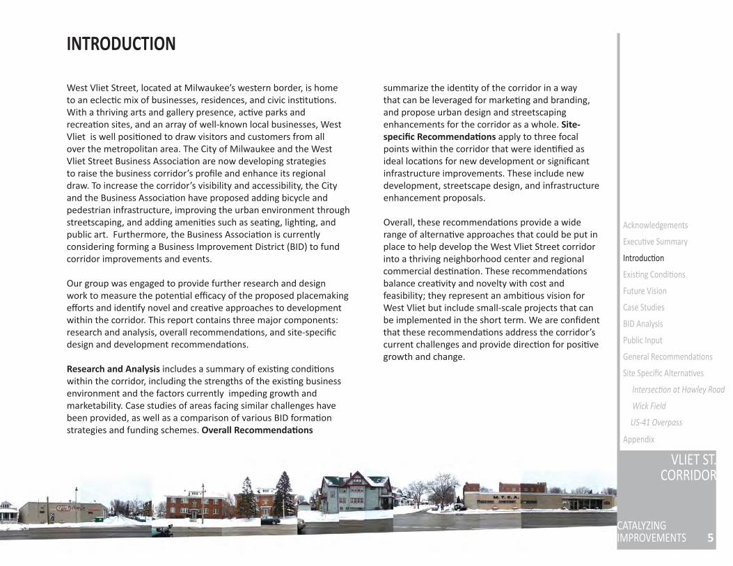
West Vliet Street, located at Milwaukee’s western border, is home to an eclec c mix of businesses, residences, and civic ins tu ons. With a thriving arts and gallery presence, ac ve parks and recrea on sites, and an array of well-known local businesses, West Vliet is well posi oned to draw visitors and customers from all over the metropolitan area. The City of Milwaukee and the West Vliet Street Business Associa on are now developing strategies to raise the business corridor’s profi le and enhance its regional draw. To increase the corridor’s visibility and accessibility, the City and the Business Associa on have proposed adding bicycle and pedestrian infrastructure, improving the urban environment through streetscaping, and adding ameni es such as sea ng, ligh ng, and public art. Furthermore, the Business Associa on is currently considering forming a Business Improvement District (BID) to fund corridor improvements and events.
Our group was engaged to provide further research and design work to measure the poten al effi cacy of the proposed placemaking eff orts and iden fy novel and crea ve approaches to development within the corridor. This report contains three major components: research and analysis, overall recommenda ons, and site-specifi c design and development recommenda ons.
Research and Analysis includes a summary of exis ng condi ons within the corridor, including the strengths of the exis ng business environment and the factors currently impeding growth and marketability. Case studies of areas facing similar challenges have been provided, as well as a comparison of various BID forma on strategies and funding schemes. Overall Recommenda ons
summarize the iden ty of the corridor in a way that can be leveraged for marke ng and branding, and propose urban design and streetscaping enhancements for the corridor as a whole. Site-specifi c Recommenda ons apply to three focal points within the corridor that were iden fi ed as ideal loca ons for new development or signifi cant infrastructure improvements. These include new development, streetscape design, and infrastructure enhancement proposals.
Overall, these recommenda ons provide a wide range of alterna ve approaches that could be put in place to help develop the West Vliet Street corridor into a thriving neighborhood center and regional commercial des na on. These recommenda ons balance crea vity and novelty with cost and feasibility; they represent an ambi ous vision for West Vliet but include small-scale projects that can be implemented in the short term. We are confi dent that these recommenda ons address the corridor’s current challenges and provide direc on for posi ve growth and change.
INTRODUCTION
EXISTING CONDITIONS
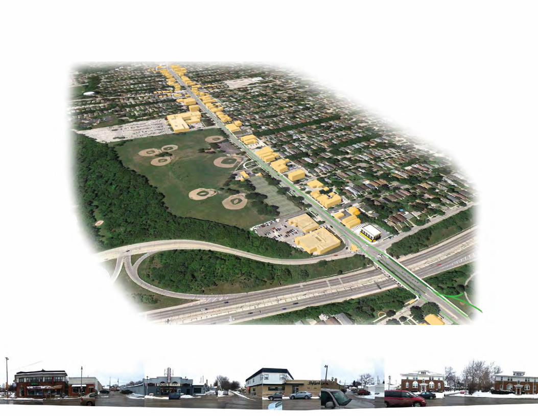
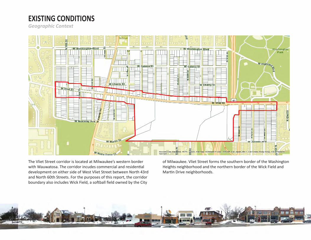
The Vliet Street corridor is located at Milwaukee’s western border with Wauwatosa. The corridor incudes commercial and residen al development on either side of West Vliet Street between North 43rd and North 60th Streets. For the purposes of this report, the corridor boundary also includes Wick Field, a so ball fi eld owned by the City
Geographic Context
of Milwaukee. Vliet Street forms the southern border of the Washington Heights neighborhood and the northern border of the Wick Field and Mar n Drive neighborhoods.
7
VLIET ST.CORRIDOR
CATALYZINGIMPROVEMENTS
Acknowledgements
Execu ve Summary
Introduc on
Exis ng Condi ons
Future Vision
Case Studies
BID Analysis
Public Input
General Recommenda ons
Site Specifi c Alterna ves
Intersec on at Hawley Road
Wick Field
US-41 Overpass
Appendix
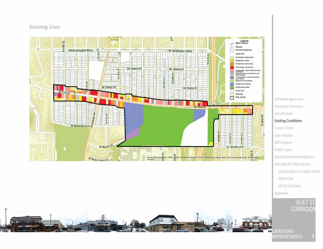
Exis ng Uses
COMMERCIALVliet Street is a thriving business corridor that has over 75 businesses and organiza ons. This corridor off ers many ameni es for all ages and is ac ve year round. The corridor is a growing art community, and is also known for its dining venues, local services, and retail shops. Along Vliet Street you will fi nd a variety of restaurants, art galleries, fl oral shops, a local pharmacy, and much more.
RESIDENTIALVliet Street housing is comprised of two-story single family homes and duplexes, as well as two- to three-story apartment and mixed-use buildings. The neighborhoods to the north and south of Vliet Street consist primarily of single family homes and duplexes.
INSTITUTIONALThe Milwaukee Public Schools headquarters is located on the south side of Vliet Street, adjacent to Wick Field. An administra ve building for the Milwaukee Police Department is situated immediately west of the US-41 overpass.
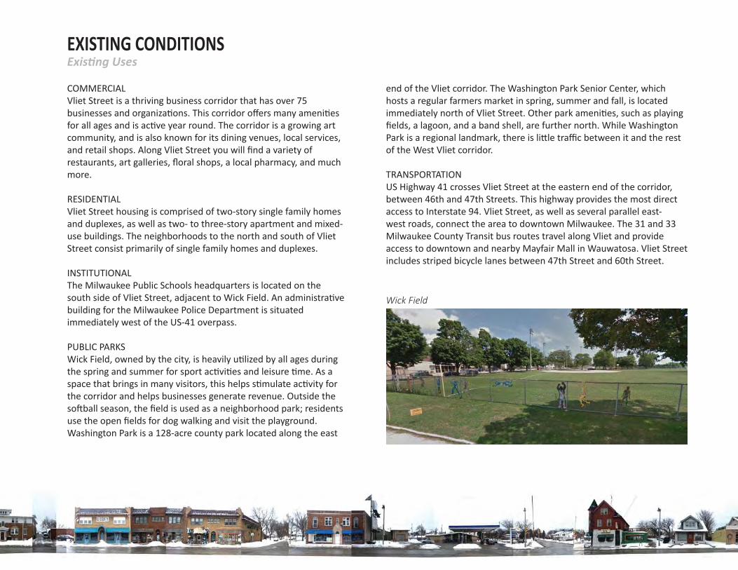
PUBLIC PARKSWick Field, owned by the city, is heavily u lized by all ages during the spring and summer for sport ac vi es and leisure me. As a space that brings in many visitors, this helps s mulate ac vity for the corridor and helps businesses generate revenue. Outside the so ball season, the fi eld is used as a neighborhood park; residents use the open fi elds for dog walking and visit the playground. Washington Park is a 128-acre county park located along the east
end of the Vliet corridor. The Washington Park Senior Center, which hosts a regular farmers market in spring, summer and fall, is located immediately north of Vliet Street. Other park ameni es, such as playing fi elds, a lagoon, and a band shell, are further north. While Washington Park is a regional landmark, there is li le traffi c between it and the rest of the West Vliet corridor.
TRANSPORTATIONUS Highway 41 crosses Vliet Street at the eastern end of the corridor, between 46th and 47th Streets. This highway provides the most direct access to Interstate 94. Vliet Street, as well as several parallel east-west roads, connect the area to downtown Milwaukee. The 31 and 33 Milwaukee County Transit bus routes travel along Vliet and provide access to downtown and nearby Mayfair Mall in Wauwatosa. Vliet Street includes striped bicycle lanes between 47th Street and 60th Street.
Exis ng Uses
Wick Field
EXISTING CONDITIONS
9
VLIET ST.CORRIDOR
CATALYZINGIMPROVEMENTS
Acknowledgements
Execu ve Summary
Introduc on
Exis ng Condi ons
Future Vision
Case Studies
BID Analysis
Public Input
General Recommenda ons
Site Specifi c Alterna ves
Intersec on at Hawley Road
Wick Field
US-41 Overpass
Appendix
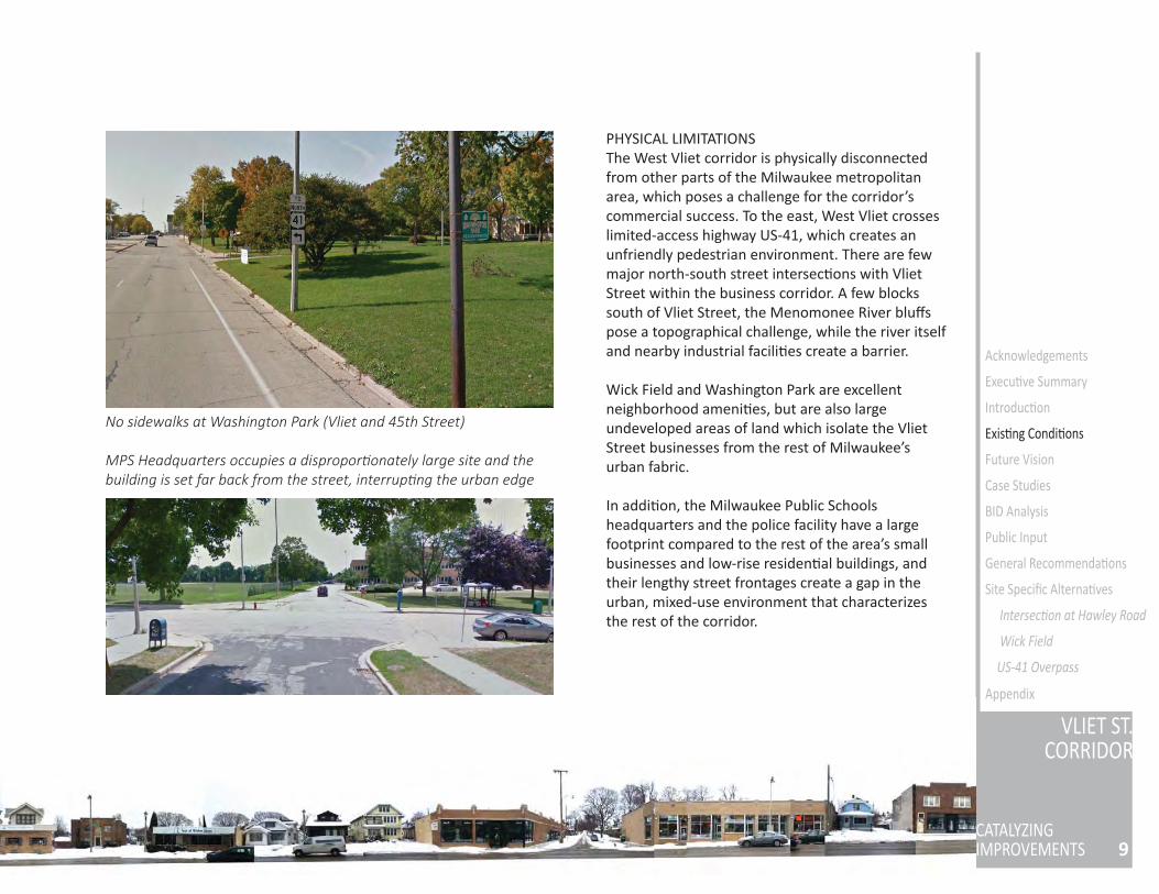
PHYSICAL LIMITATIONSThe West Vliet corridor is physically disconnected from other parts of the Milwaukee metropolitan area, which poses a challenge for the corridor’s commercial success. To the east, West Vliet crosses limited-access highway US-41, which creates an unfriendly pedestrian environment. There are few major north-south street intersec ons with Vliet Street within the business corridor. A few blocks south of Vliet Street, the Menomonee River bluff s pose a topographical challenge, while the river itself and nearby industrial facili es create a barrier.
Wick Field and Washington Park are excellent neighborhood ameni es, but are also large undeveloped areas of land which isolate the Vliet Street businesses from the rest of Milwaukee’s urban fabric.
In addi on, the Milwaukee Public Schools headquarters and the police facility have a large footprint compared to the rest of the area’s small businesses and low-rise residen al buildings, and their lengthy street frontages create a gap in the urban, mixed-use environment that characterizes the rest of the corridor.
No sidewalks at Washington Park (Vliet and 45th Street)
MPS Headquarters occupies a dispropor onately large site and the building is set far back from the street, interrup ng the urban edge

11
VLIET ST.CORRIDOR
CATALYZINGIMPROVEMENTS
Acknowledgements
Execu ve Summary
Introduc on
Exis ng Condi ons
Future Vision
Case Studies
BID Analysis
Public Input
General Recommenda ons
Site Specifi c Alterna ves
Intersec on at Hawley Road
Wick Field
US-41 Overpass
Appendix
Problem Statement and Project Objec vesFUTURE VISION
PROBLEM STATEMENTThe Vliet Street corridor lacks regional retail draw and is physically disconnected from the urban fabric of Milwaukee, detrac ng from the street’s poten al as a vital neighborhood center and commercial des na on. While the corridor is home to numerous locally owned businesses and popular parks, it has yet to develop a strong iden ty as a des na on within the metropolitan area.
PROJECT OBECTIVES
Solidify corridor iden ty for branding• Develop a marketable brand for the corridor,
based on its strengths and landmarks
Expand corridor accessibility• Improve infrastructure quality, safety, and
aesthe cs to promote easier pedestrian, bicycle and vehicular traffi c fl ow into the corridor
Improve business environment• Develop funding and support mechanisms to
assist exis ng businesses
Increase regional draw• Create proposals for landmark developments
and des na on ac vi es along the Vliet Street corridor
CASE STUDY: URBAN DESIGN - BICYCLE & PEDESTRIAN ENVIRONMENT IMPROVEMENTS
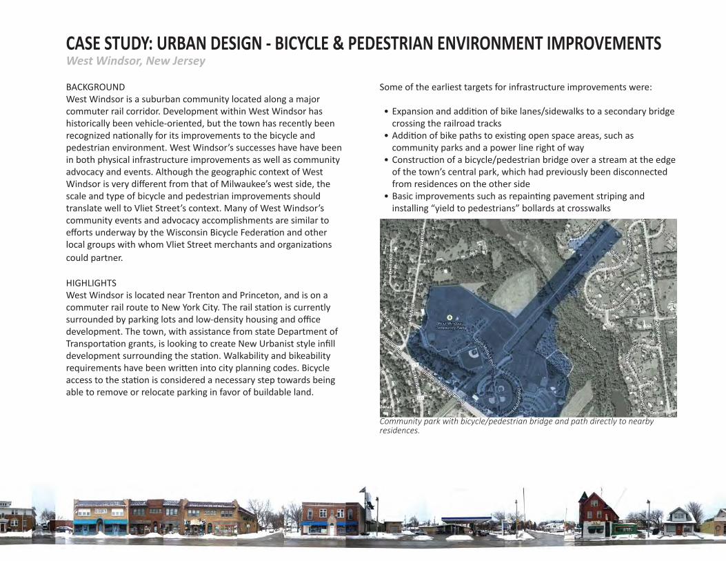
BACKGROUNDWest Windsor is a suburban community located along a major commuter rail corridor. Development within West Windsor has historically been vehicle-oriented, but the town has recently been recognized na onally for its improvements to the bicycle and pedestrian environment. West Windsor’s successes have have been in both physical infrastructure improvements as well as community advocacy and events. Although the geographic context of West Windsor is very diff erent from that of Milwaukee’s west side, the scale and type of bicycle and pedestrian improvements should translate well to Vliet Street’s context. Many of West Windsor’s community events and advocacy accomplishments are similar to eff orts underway by the Wisconsin Bicycle Federa on and other local groups with whom Vliet Street merchants and organiza ons could partner.
HIGHLIGHTSWest Windsor is located near Trenton and Princeton, and is on a commuter rail route to New York City. The rail sta on is currently surrounded by parking lots and low-density housing and offi ce development. The town, with assistance from state Department of Transporta on grants, is looking to create New Urbanist style infi ll development surrounding the sta on. Walkability and bikeability requirements have been wri en into city planning codes. Bicycle access to the sta on is considered a necessary step towards being able to remove or relocate parking in favor of buildable land.
Some of the earliest targets for infrastructure improvements were:
• Expansion and addi on of bike lanes/sidewalks to a secondary bridge crossing the railroad tracks
• Addi on of bike paths to exis ng open space areas, such as community parks and a power line right of way
• Construc on of a bicycle/pedestrian bridge over a stream at the edge of the town’s central park, which had previously been disconnected from residences on the other side
• Basic improvements such as repain ng pavement striping and installing “yield to pedestrians” bollards at crosswalks
Community park with bicycle/pedestrian bridge and path directly to nearby residences.
West Windsor, New Jersey
13
VLIET ST.CORRIDOR
CATALYZINGIMPROVEMENTS
Acknowledgements
Execu ve Summary
Introduc on
Exis ng Condi ons
Future Vision
Case Studies
BID Analysis
Public Input
General Recommenda ons
Site Specifi c Alterna ves
Intersec on at Hawley Road
Wick Field
US-41 Overpass
Appendix
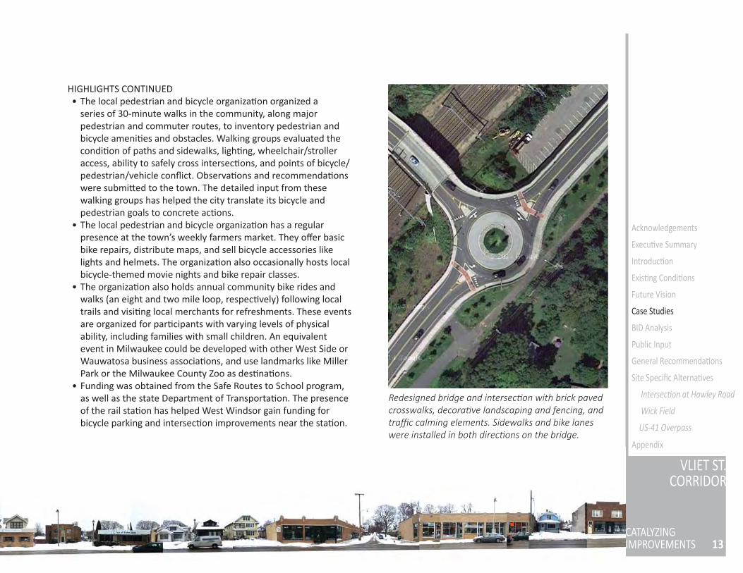
HIGHLIGHTS CONTINUED • The local pedestrian and bicycle organiza on organized a
series of 30-minute walks in the community, along major pedestrian and commuter routes, to inventory pedestrian and bicycle ameni es and obstacles. Walking groups evaluated the condi on of paths and sidewalks, ligh ng, wheelchair/stroller access, ability to safely cross intersec ons, and points of bicycle/pedestrian/vehicle confl ict. Observa ons and recommenda ons were submi ed to the town. The detailed input from these walking groups has helped the city translate its bicycle and pedestrian goals to concrete ac ons.
• The local pedestrian and bicycle organiza on has a regular presence at the town’s weekly farmers market. They off er basic bike repairs, distribute maps, and sell bicycle accessories like lights and helmets. The organiza on also occasionally hosts local bicycle-themed movie nights and bike repair classes.
• The organiza on also holds annual community bike rides and walks (an eight and two mile loop, respec vely) following local trails and visi ng local merchants for refreshments. These events are organized for par cipants with varying levels of physical ability, including families with small children. An equivalent event in Milwaukee could be developed with other West Side or Wauwatosa business associa ons, and use landmarks like Miller Park or the Milwaukee County Zoo as des na ons.
• Funding was obtained from the Safe Routes to School program, as well as the state Department of Transporta on. The presence of the rail sta on has helped West Windsor gain funding for bicycle parking and intersec on improvements near the sta on.
Redesigned bridge and intersec on with brick paved crosswalks, decora ve landscaping and fencing, and traffi c calming elements. Sidewalks and bike lanes were installed in both direc ons on the bridge.
CASE STUDY: URBAN DESIGN - INFILL & CONNECTIVITY
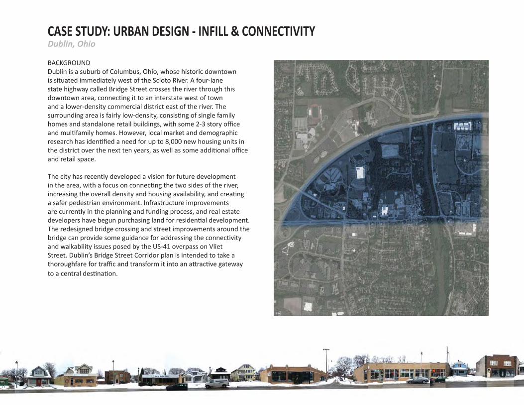
BACKGROUNDDublin is a suburb of Columbus, Ohio, whose historic downtown is situated immediately west of the Scioto River. A four-lane state highway called Bridge Street crosses the river through this downtown area, connec ng it to an interstate west of town and a lower-density commercial district east of the river. The surrounding area is fairly low-density, consis ng of single family homes and standalone retail buildings, with some 2-3 story offi ce and mul family homes. However, local market and demographic research has iden fi ed a need for up to 8,000 new housing units in the district over the next ten years, as well as some addi onal offi ce and retail space.
The city has recently developed a vision for future development in the area, with a focus on connec ng the two sides of the river, increasing the overall density and housing availability, and crea ng a safer pedestrian environment. Infrastructure improvements are currently in the planning and funding process, and real estate developers have begun purchasing land for residen al development. The redesigned bridge crossing and street improvements around the bridge can provide some guidance for addressing the connec vity and walkability issues posed by the US-41 overpass on Vliet Street. Dublin’s Bridge Street Corridor plan is intended to take a thoroughfare for traffi c and transform it into an a rac ve gateway to a central des na on.
Dublin, Ohio
15
VLIET ST.CORRIDOR
CATALYZINGIMPROVEMENTS
Acknowledgements
Execu ve Summary
Introduc on
Exis ng Condi ons
Future Vision
Case Studies
BID Analysis
Public Input
General Recommenda ons
Site Specifi c Alterna ves
Intersec on at Hawley Road
Wick Field
US-41 Overpass
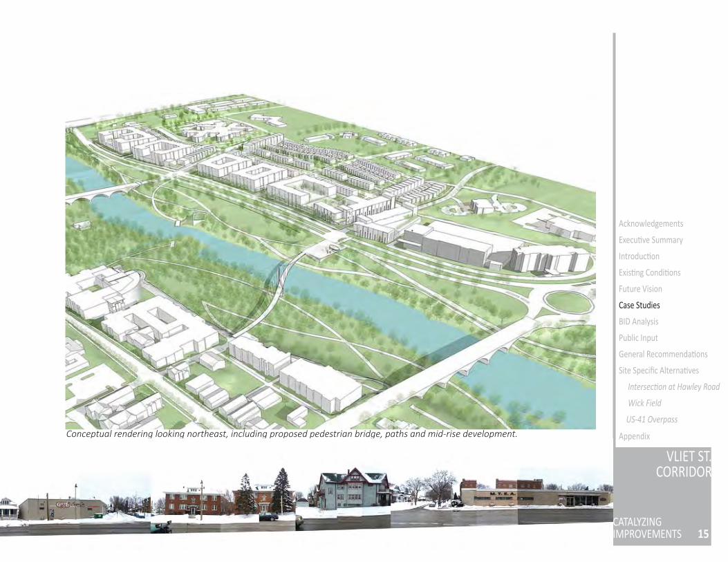
AppendixConceptual rendering looking northeast, including proposed pedestrian bridge, paths and mid-rise development.
HIGHLIGHTS OF THE PLAN • The city an cipates a demographic shi away from families
with children living in Dublin and commu ng into Columbus, toward more childless adults working in Dublin or reaching re rement age. New development therefore priori zes smaller housing op ons and pedestrian access between housing and employment/retail centers.
• Major employers such as Na onwide Insurance, Wendy’s corporate headquarters, and Cardinal Health are within walking distance of the historic downtown, but are not easily and safely accessible by foot. This is comparable to major employers (such as Miller Brewing and Harley-Davidson) located near Vliet Street but not truly accessible to and from the corridor. Dublin’s plan addresses this issue by increasing the number of downtown housing units and adding pedestrian infrastructure like paths and bridges, so that housing and job centers are linked.
• Bridge Street is a busy connec ve corridor for vehicle traffi c, so traffi c calming and walkability improvements had to be balanced with maintaining a reasonable level of vehicle access. Proposed infrastructure changes include an expanded median and landscaped traffi c circles, as well as off -street path networks for cyclists and pedestrians. Where Bridge Street contains long uninterrupted blocks, the city is crea ng new intersec ons to calm Bridge Street traffi c and provide alternate routes.
• Funding for the infrastructure improvements has primarily come from exis ng city capital improvement funds, supplemented by Tax Increment Financing districts around the Bridge Street Corridor.
• Infi ll development is a high priority for both sides of the river, with the inten on of crea ng a gateway to the historic downtown. A form based code has been approved for the area, including minimum building heights and residen al densi es. The city seeks to maximize “visibility” for riverfront development, and proposed developments fron ng the river are three stories in height. This creates the impression of a wall around the river, framing the riverfront parkland and crea ng visual symmetry between the two sides.
• The City of Dublin has purchased riverfront land for a new park, something the Vliet corridor already has with Washington Park and Wick Field present on either side of US-41. Dublin’s plan includes a new pedestrian bridge over the river, separa ng pedestrians from busy Bridge Street vehicle traffi c and connec ng walking paths for both commu ng and recrea onal walking.
17
VLIET ST.CORRIDOR
CATALYZINGIMPROVEMENTS
Acknowledgements
Execu ve Summary
Introduc on
Exis ng Condi ons
Future Vision
Case Studies
BID Analysis
Public Input
General Recommenda ons
Site Specifi c Alterna ves
Intersec on at Hawley Road
Wick Field
US-41 Overpass
Appendix
CASE STUDY: URBAN DESIGN - STREETSCAPING IMPROVEMENTS
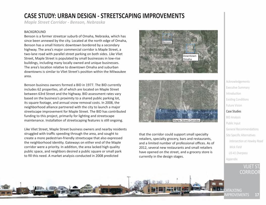
BACKGROUNDBenson is a former streetcar suburb of Omaha, Nebraska, which has since been annexed by the city. Located at the north edge of Omaha, Benson has a small historic downtown bordered by a secondary highway. The area’s major commercial corridor is Maple Street, a two-lane road with parallel street parking on both sides. Like Vliet Street, Maple Street is populated by small businesses in low-rise buildings, including many locally owned and unique businesses. The area’s loca on rela ve to downtown Omaha and suburban downtowns is similar to Vliet Street’s posi on within the Milwaukee area.
Benson business owners formed a BID in 1977. The BID currently includes 62 proper es, all of which are located on Maple Street between 63rd Street and the highway. BID assessment rates vary based on the business’s proximity to a shared public parking lot, its square footage, and annual snow removal costs. In 2008, the neighborhood alliance partnered with the city to launch a major streetscape improvement for Maple Street. The BID has contributed funding to this project, primarily for ligh ng and streetscape maintenance. Installa on of streetscaping features is s ll ongoing.
Like Vliet Street, Maple Street business owners and nearby residents struggled with traffi c speeding through the area, and sought to create a more pedestrian-friendly streetscape that also expressed the neighborhood iden ty. Gateways on either end of the Maple corridor were a priority. In addi on, the area lacked high quality public space, and neighbors desired a public square or small park to fi ll this need. A market analysis conducted in 2008 predicted
DowntownOmaha
Benson
Maple Street Corridor
Maple Street Corridor - Benson, Nebraska
that the corridor could support small specialty retailers, specialty grocery, bars and restaurants, and a limited number of professional offi ces. As of 2012, several new restaurants and small retailers have opened on the street, and a grocery store is currently in the design stages.
PROJECT HIGHLIGHTS• In 2011, the Omaha City Council allocated $45,250 to the BID for new
street ligh ng. The new acorn ligh ng uses energy-effi cient LEDs, and provides brighter ligh ng than the previous fi xtures. Improving ligh ng to address safety concerns was a priority for neighbors and customers. The BID will repay the city for the cost of the light fi xtures over a ten year period. In 2012, the BID paid $5,304 to the city, and $2,329 for hardware to a ach banners to the poles.
• An “East Gateway” project was completed in 2013. The eastern end of Maple Street fl ows into the Northwest Radial Highway, so crea ng an iden fi able entrance to the business corridor and slowing traffi c was key. A “Welcome to Historic Benson” sign was installed, trees were planted, and the confusing intersec on was reconfi gured. The majority of funding for the $560,000 project came from federal transporta on safety funds, with the BID contribu ng funds for landscaping and maintenance and state grants making up addi onal costs.
• A rain garden at the eastern end of the corridor was also completed in 2013. The rain garden includes landscaping at the East Gateway as well as a bioreten on area in a small park. Technical assistance for the design and construc on was provided by the City of Omaha, and landscape maintenance will be paid for by the BID.
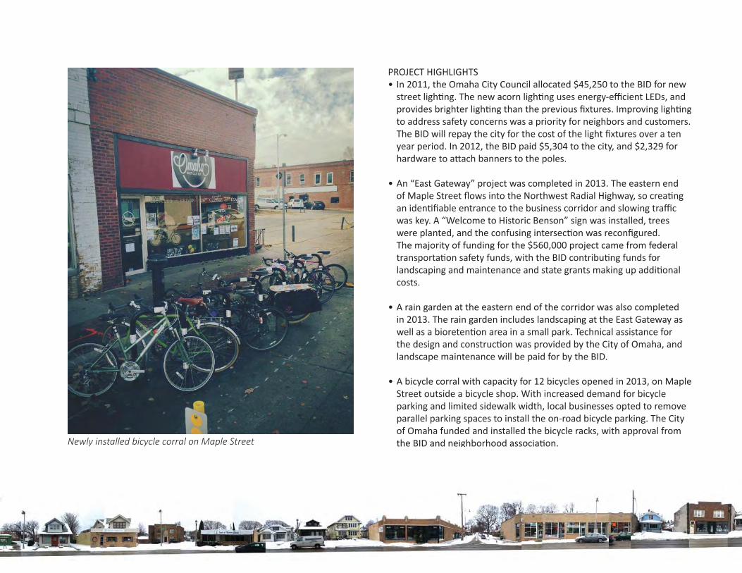
• A bicycle corral with capacity for 12 bicycles opened in 2013, on Maple Street outside a bicycle shop. With increased demand for bicycle parking and limited sidewalk width, local businesses opted to remove parallel parking spaces to install the on-road bicycle parking. The City of Omaha funded and installed the bicycle racks, with approval from the BID and neighborhood associa on.Newly installed bicycle corral on Maple Street
19
VLIET ST.CORRIDOR
CATALYZINGIMPROVEMENTS
Acknowledgements
Execu ve Summary
Introduc on
Exis ng Condi ons
Future Vision
Case Studies
BID Analysis
Public Input
General Recommenda ons
Site Specifi c Alterna ves
Intersec on at Hawley Road
Wick Field
US-41 Overpass
Appendix
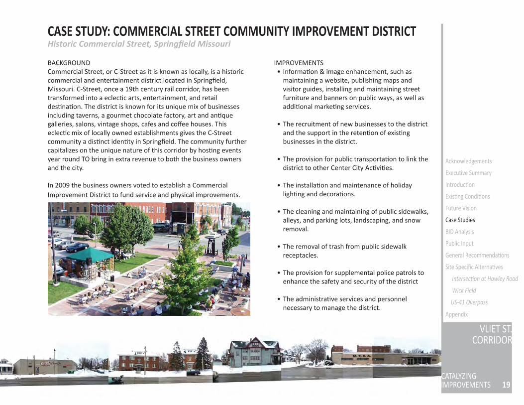
CASE STUDY: COMMERCIAL STREET COMMUNITY IMPROVEMENT DISTRICT
BACKGROUNDCommercial Street, or C-Street as it is known as locally, is a historic commercial and entertainment district located in Springfi eld, Missouri. C-Street, once a 19th century rail corridor, has been transformed into a eclec c arts, entertainment, and retail des na on. The district is known for its unique mix of businesses including taverns, a gourmet chocolate factory, art and an que galleries, salons, vintage shops, cafes and coff ee houses. This eclec c mix of locally owned establishments gives the C-Street community a dis nct iden ty in Springfi eld. The community further capitalizes on the unique nature of this corridor by hos ng events year round TO bring in extra revenue to both the business owners and the city.
In 2009 the business owners voted to establish a Commercial Improvement District to fund service and physical improvements.
IMPROVEMENTS• Informa on & image enhancement, such as
maintaining a website, publishing maps and visitor guides, installing and maintaining street furniture and banners on public ways, as well as addi onal marke ng services.
• The recruitment of new businesses to the district and the support in the reten on of exis ng businesses in the district.
• The provision for public transporta on to link the district to other Center City Ac vi es.
• The installa on and maintenance of holiday ligh ng and decora ons.
• The cleaning and maintaining of public sidewalks, alleys, and parking lots, landscaping, and snow removal.
• The removal of trash from public sidewalk receptacles.
• The provision for supplemental police patrols to enhance the safety and security of the district
• The administra ve services and personnel necessary to manage the district.
Historic Commercial Street, Springfi eld Missouri
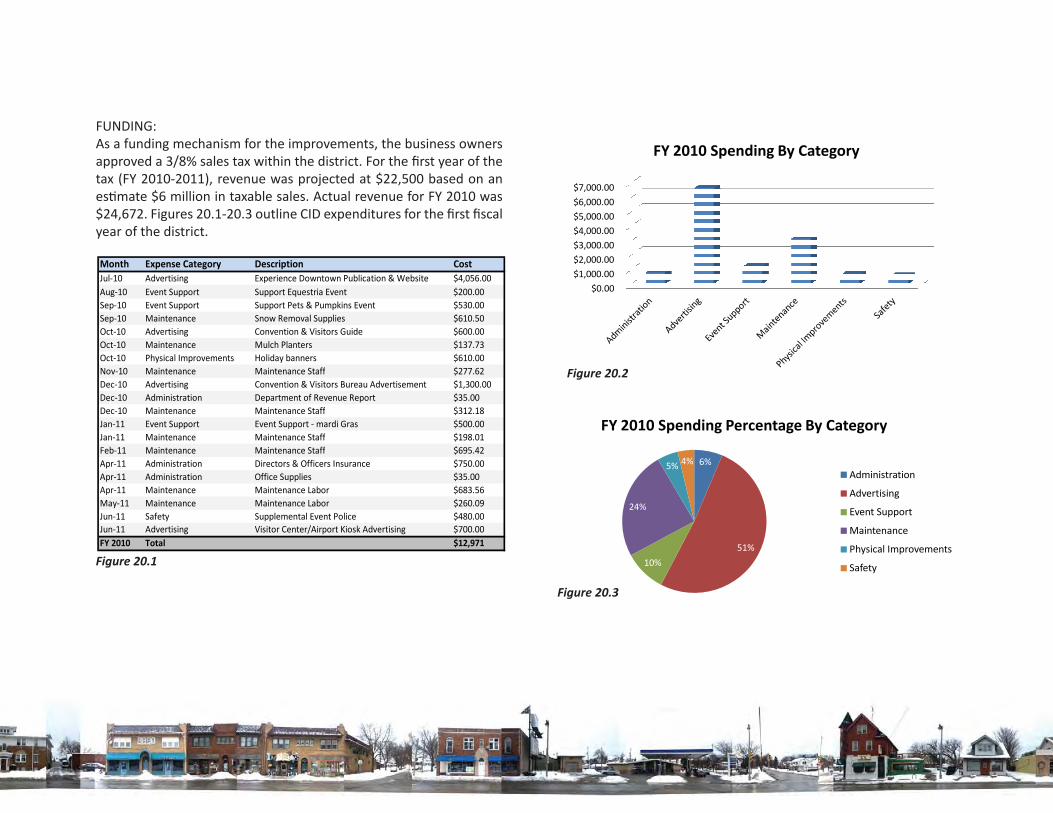
FUNDING:As a funding mechanism for the improvements, the business owners approved a 3/8% sales tax within the district. For the fi rst year of the tax (FY 2010-2011), revenue was projected at $22,500 based on an es mate $6 million in taxable sales. Actual revenue for FY 2010 was $24,672. Figures 20.1-20.3 outline CID expenditures for the fi rst fi scal year of the district.
Figure 20.1
Figure 20.3
Figure 20.2
21
VLIET ST.CORRIDOR
CATALYZINGIMPROVEMENTS
Acknowledgements
Execu ve Summary
Introduc on
Exis ng Condi ons
Future Vision
Case Studies
BID Analysis
Public Input
General Recommenda ons
Site Specifi c Alterna ves
Intersec on at Hawley Road
Wick Field
US-41 Overpass
Appendix
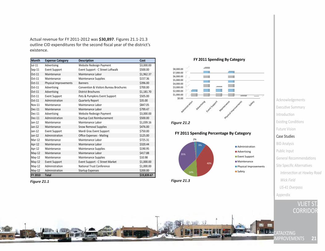
Figure 21.1
Figure 21.2
Figure 21.3
Actual revenue for FY 2011-2012 was $30,897. Figures 21.1-21.3 outline CID expenditures for the second fi scal year of the district’s existence.
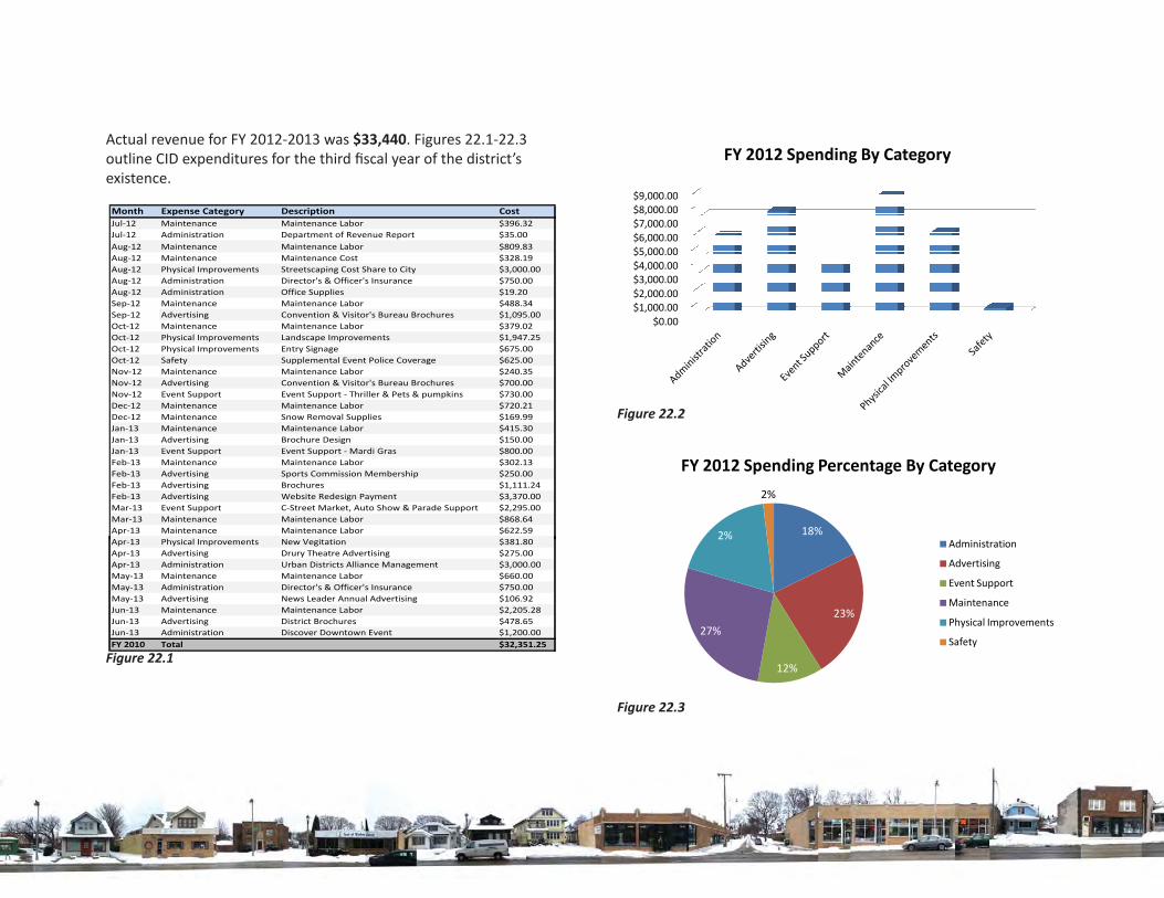
Figure 22.1
Figure 22.3
Actual revenue for FY 2012-2013 was $33,440. Figures 22.1-22.3 outline CID expenditures for the third fi scal year of the district’s existence.
Figure 22.2
23
VLIET ST.CORRIDOR
CATALYZINGIMPROVEMENTS
Acknowledgements
Execu ve Summary
Introduc on
Exis ng Condi ons
Future Vision
Case Studies
BID Analysis
Public Input
General Recommenda ons
Site Specifi c Alterna ves
Intersec on at Hawley Road
Wick Field
US-41 Overpass
Appendix
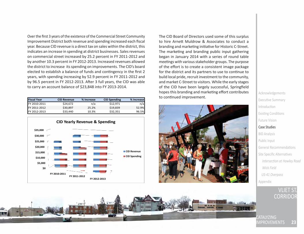
Over the fi rst 3 years of the existence of the Commercial Street Community Improvement District both revenue and spending increased each fi scal year. Because CID revenue is a direct tax on sales within the district, this indicates an increase in spending at district businesses. Sales revenues on commercial street increased by 25.2 percent in FY 2011-2012 and by another 10.3 percent in FY 2012-2013. Increased revenues allowed the district to increase its spending on improvements. The CID’s board elected to establish a balance of funds and con ngency in the fi rst 2 years, with spending increasing by 52.9 percent in FY 2011-2012 and by 96.5 percent in FY 2012-2013. A er 3 full years, the CID was able to carry an account balance of $23,848 into FY 2013-2014.
The CID Board of Directors used some of this surplus to hire Arne Muldrow & Associates to conduct a branding and marke ng ini a ve for Historic C-Street. The marke ng and branding public input gathering began in January 2014 with a series of round table mee ngs with various stakeholder groups. The purpose of the eff ort is to create a consistent image package for the district and its partners to use to con nue to build local pride, recruit investment to the community, and market C-Street to visitors. While the early stages of the CID have been largely successful, Springfi eld hopes this branding and marke ng eff ort contributes to con nued improvement.
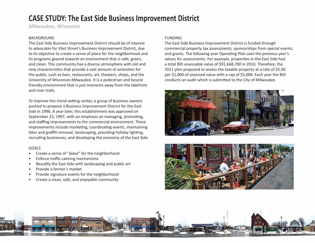
BACKGROUNDThe East Side Business Improvement District should be of interest to advocates for Vliet Street’s Business Improvement District, due to its objec ve to create a sense of place for the neighborhood and its programs geared towards an environment that is safe, green, and clean. This community has a diverse atmosphere with old and new characteris cs that provide a vast amount of ameni es for the public, such as bars, restaurants, art, theaters, shops, and the University of Wisconsin-Milwaukee. It is a pedestrian and bicycle friendly environment that is just moments away from the lakefront and river trails.
To improve this trend-se ng center, a group of business owners pushed to propose a Business Improvement District for the East Side in 1996. A year later, this establishment was approved on September 23, 1997, with an emphasis on managing, promo ng, and staffi ng improvements to the commercial environment. These improvements include marke ng, coordina ng events, maintaining li er and graffi removal, landscaping, providing holiday ligh ng, recrui ng businesses, and developing the economy of the East Side.
GOALS • Create a sense of “place” for the neighborhood• Enforce traffi c calming mechanisms• Beau fy the East Side with landscaping and public art• Provide a farmer’s market • Provide signature events for the neighborhood • Create a clean, safe, and enjoyable community
CASE STUDY: The East Side Business Improvement DistrictMilwaukee, Wisconsin
FUNDINGThe East Side Business Improvement District is funded through commercial property tax assessments, sponsorships from special events, and grants. The following year Opera ng Plan uses the previous year’s values for assessments. For example, proper es in the East Side had a total BID assessable value of $91,668,700 in 2010. Therefore, the 2011 plan proposed to assess the taxable property at a rate of $5.00 per $1,000 of assessed value with a cap of $5,000. Each year the BID conducts an audit which is submi ed to the City of Milwaukee.
25
VLIET ST.CORRIDOR
CATALYZINGIMPROVEMENTS
Acknowledgements
Execu ve Summary
Introduc on
Exis ng Condi ons
Future Vision
Case Studies
BID Analysis
Public Input
General Recommenda ons
Site Specifi c Alterna ves
Intersec on at Hawley Road
Wick Field
US-41 Overpass
Appendix
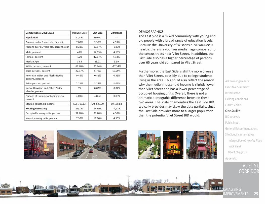
DEMOGRAPHICSThe East Side is a mixed community with young and old people with a broad range of educa on levels. Because the University of Wisconsin-Milwaukee is nearby, there is a younger median age compared to the census tracts near Vliet Street. In addi on, the East Side also has a higher percentage of persons over 65 years old compared to Vliet Street.
Furthermore, the East Side is slightly more diverse than Vliet Street, possibly due to college students living in the area. This could also refl ect the reason why the median household income is slightly lower than Vliet Street and has a lower percentage of occupied housing units. Overall, there is not a drama c demograhic diff erence between these two areas. The scale of ameni es the East Side BID typically provides may skew the data par ally, since the East Side provides more to a larger popula on than the poten al Vliet Street BID would.
Demographics 2008-2012 West Vliet Street East Side Diff erence
Popula on 21,892 30,077 ----
Persons under 5 years old, percent 7.08% 2.55% 4.53%
Persons over 65 years old, percent, year 8.28% 10.17% -1.89%
Male, percent 48% 52.13% -4.13%
Female, percent 52% 47.87% 4.13%
Median Age 33.8 28.21 5.59
White persons, percent 69.40% 86.74% -17.34%
Black persons, percent 22.57% 5.78% 16.79%
American Indian and Alaska Na ve persons, percent
0.46% 0.81% -0.35%
Asian persons, percent 2.21% 3.22% -1.01%
Na ve Hawaiian and Other Pacifi c Islander, percent
0% 0.02% -0.02%
Persons of Hispanic or La no origin, percent
4.01% 4.86% -0.85%
Median household income $55,713.13 $46,523.30 $9,189.83
Housing Occupancy 10,187 14,966 -4,779
Occupied housing units, percent 92.70% 88.20% 4.50%
Vacant housing units, percent 7.30% 11.80% -4.50%
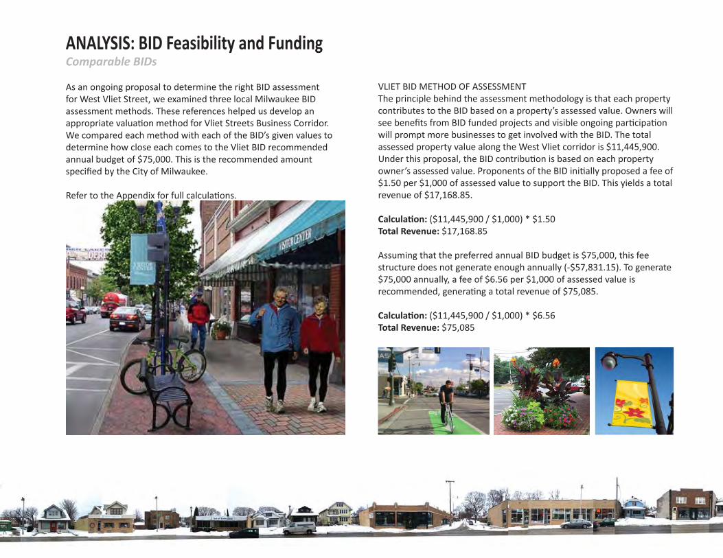
ANALYSIS: BID Feasibility and FundingComparable BIDs
As an ongoing proposal to determine the right BID assessment for West Vliet Street, we examined three local Milwaukee BID assessment methods. These references helped us develop an appropriate valua on method for Vliet Streets Business Corridor. We compared each method with each of the BID’s given values to determine how close each comes to the Vliet BID recommended annual budget of $75,000. This is the recommended amount specifi ed by the City of Milwaukee.
Refer to the Appendix for full calcula ons.
VLIET BID METHOD OF ASSESSMENT The principle behind the assessment methodology is that each property contributes to the BID based on a property’s assessed value. Owners will see benefi ts from BID funded projects and visible ongoing par cipa on will prompt more businesses to get involved with the BID. The total assessed property value along the West Vliet corridor is $11,445,900. Under this proposal, the BID contribu on is based on each property owner’s assessed value. Proponents of the BID ini ally proposed a fee of $1.50 per $1,000 of assessed value to support the BID. This yields a total revenue of $17,168.85. Calcula on: ($11,445,900 / $1,000) * $1.50Total Revenue: $17,168.85
Assuming that the preferred annual BID budget is $75,000, this fee structure does not generate enough annually (-$57,831.15). To generate $75,000 annually, a fee of $6.56 per $1,000 of assessed value is recommended, genera ng a total revenue of $75,085.
Calcula on: ($11,445,900 / $1,000) * $6.56Total Revenue: $75,085
27
VLIET ST.CORRIDOR
CATALYZINGIMPROVEMENTS
Acknowledgements
Execu ve Summary
Introduc on
Exis ng Condi ons
Future Vision
Case Studies
BID Analysis
Public Input
General Recommenda ons
Site Specifi c Alterna ves
Intersec on at Hawley Road
Wick Field
US-41 Overpass
Appendix
BID 41: DOWNER AVENUE The assessment of BID 41 is a combina on of the assessed value of property and linear street footage of property with a maximum assessment of $10,000 of assessed value per parcel.
Calcula on: BID Special Assessment per Assessed Value(Assessed Value / Total Assessed Value) * Annual BID Budget BID Special Assessment per Linear Footage(Linear Footage / Total Linear Footage) * Annual BID Budget Weighted Average(BID Special Assessment per Assessed Value * .50) + (BID Special Assessment per Linear Footage * .50) Total Revenue: $75,000
BID 27: WEST BURLEIGH STREET Proposed BID ac vi es on West Burleigh Street are not solely supported by a local business corridor, but district-wide to spread the cost across a greater number of proper es. Overall, proper es are assessed at a rate of $3.70 per $1,000 of assessed value. However, depending on a property’s assessed value, a property owner may pay a monthly fl at rate of either $100.00 or $150.00 instead of the $3.70 per $1,000.00 of assessed value.
Applying this strategy to the Vliet Street Business Corridor, we suggest using four fl at rates for assessment instead of two fl at rates as seen with BID 27. Assessment values between $1-$150,000 pay a fl at monthly rate of $50. Values between $150,001-$250,000 pay $100 each month, $250,001-$350,000 pays $150 each month, and those exceeding $350,001 pay $200 each month. The corridor needs to average $6,600 of monthly revenue to meet the annual budget of $75,000. Total business contribu ons need to average $114.00 per business a month in order to reach the annual budget.
BID 38: CESAR E. CHAVEZ DRIVEThe assessment of BID 38 is a fl at fee of $500 per parcel of property with the excep on of tax-exempt proper es. The Vliet BID has a total of 55 proper es. If applying BID 38’s method of assessment, a fl at fee of $1,368 per parcel per year is recommended to gain a total revenue of $75,240. Calcula on: 55 proper es * $1,368Total Revenue: $75,240
ANALYSIS: BID Feasibility and FundingRecommenda ons
A er analyzing each of the local BID’s assessment methods with considera on of the Vliet Street Business Corridor property assessed value rate of $1.50 per $1,000 and an annual BID budget of $75,000, we came up with three recommenda ons for assessment rates and methodology. Full calcula ons can be found in the appendix.
Recommenda on A: Monthly fl at rate of $114 per business property, yielding an annual BID revenue of $75,000.
This fi rst recommenda on proposes that the Vliet BID assess at a fl at rate of $114 a month per business property to be able to reach the annual BID budget of $75,000. Having a monthly fl at rate for each business makes the monthly fee look more like a membership fee instead of a monthly bill, since there are no cents or fl uctua ng monthly payments.
Recommenda on B: Monthly fl at rate of $76 per business proper es with an annual BID budget of $50,000.
Many local BIDs in the Milwaukee area has applied for federal and state grants to help fund their projects. This recommenda on proposes that with federal and/or state grants, business proper es will have a lower monthly payment less than the fi rst recommenda on method assessment of a fl at rate of $114 per business property.
According to the East Side BID case study, their bike ramp project cost $480,000 and the BID covered $47,000. With pedestrian and bicycle infrastructure improvements needed throughout the
Vliet corridor, we can assume that $50,000 is needed from the BID if grants cover the remaining cost of a similar project. With 55 business proper es with an annual assessed total value of $11,445,900, each business property would pay a monthly fl at rate of $76 to reach $50,000. The City or the BID can apply for state transporta on grants to cover the remainder of such project costs.
Recommenda on C: Method assessment of $4.40 per $1,000 of assessed property value, yielding an annual BID budget of $50,000.
This recommenda on proposes that the proposed Vliet BID method assessment of $1.50 per $1,000 be increased to $4.40 per $1,000 to reach at least $50,000. This method assessment will assess all business proper es equally based from their total assessed value, which is more likely to be perceived as fair to all business owners. In addi on, minor fl uctua ons in value (under $1,000) are unlikely to aff ect a business’s payment threshold. With an annual BID budget of $50,000 and grants, this method assessment can s ll acquire the necessary funds for the proposed projects.
29
VLIET ST.CORRIDOR
CATALYZINGIMPROVEMENTS
Acknowledgements
Execu ve Summary
Introduc on
Exis ng Condi ons
Future Vision
Case Studies
BID Analysis
Public Input
General Recommenda ons
Site Specifi c Alterna ves
Intersec on at Hawley Road
Wick Field
US-41 Overpass
Appendix
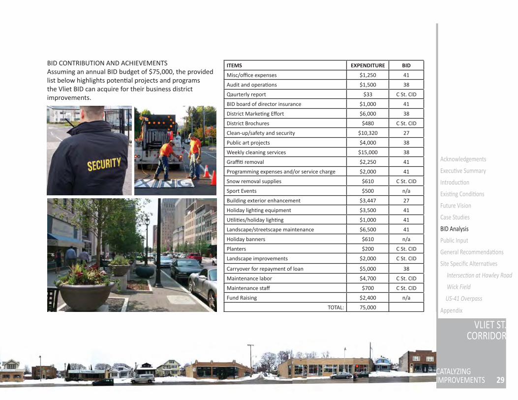
ITEMS EXPENDITURE BID
Misc/offi ce expenses $1,250 41
Audit and opera ons $1,500 38
Qaurterly report $33 C St. CID
BID board of director insurance $1,000 41
District Marke ng Eff ort $6,000 38
District Brochures $480 C St. CID
Clean-up/safety and security $10,320 27
Public art projects $4,000 38
Weekly cleaning services $15,000 38
Graffi removal $2,250 41
Programming expenses and/or service charge $2,000 41
Snow removal supplies $610 C St. CID
Sport Events $500 n/a
Building exterior enhancement $3,447 27
Holiday ligh ng equipment $3,500 41
U li es/holiday ligh ng $1,000 41
Landscape/streetscape maintenance $6,500 41
Holiday banners $610 n/a
Planters $200 C St. CID
Landscape improvements $2,000 C St. CID
Carryover for repayment of loan $5,000 38
Maintenance labor $4,700 C St. CID
Maintenance staff $700 C St. CID
Fund Raising $2,400 n/a
TOTAL: 75,000
BID CONTRIBUTION AND ACHIEVEMENTSAssuming an annual BID budget of $75,000, the provided list below highlights poten al projects and programs the Vliet BID can acquire for their business district improvements.
SUMMARY: Public Input and Corridor Iden ty
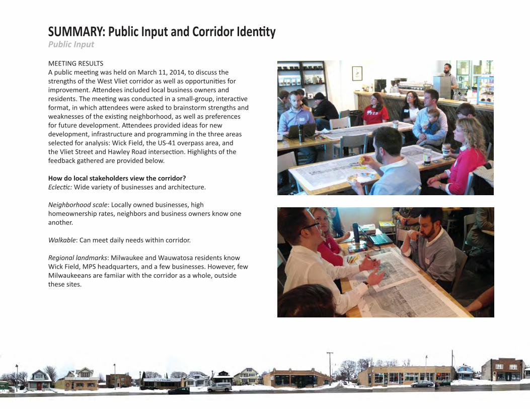
MEETING RESULTSA public mee ng was held on March 11, 2014, to discuss the strengths of the West Vliet corridor as well as opportuni es for improvement. A endees included local business owners and residents. The mee ng was conducted in a small-group, interac ve format, in which a endees were asked to brainstorm strengths and weaknesses of the exis ng neighborhood, as well as preferences for future development. A endees provided ideas for new development, infrastructure and programming in the three areas selected for analysis: Wick Field, the US-41 overpass area, and the Vliet Street and Hawley Road intersec on. Highlights of the feedback gathered are provided below.
How do local stakeholders view the corridor?Eclec c: Wide variety of businesses and architecture.
Neighborhood scale: Locally owned businesses, high homeownership rates, neighbors and business owners know one another.
Walkable: Can meet daily needs within corridor.
Regional landmarks: Milwaukee and Wauwatosa residents know Wick Field, MPS headquarters, and a few businesses. However, few Milwaukeeans are famiiar with the corridor as a whole, outside these sites.
Public Input
31
VLIET ST.CORRIDOR
CATALYZINGIMPROVEMENTS
Acknowledgements
Execu ve Summary
Introduc on
Exis ng Condi ons
Future Vision
Case Studies
BID Analysis
Public Input
General Recommenda ons
Site Specifi c Alterna ves
Intersec on at Hawley Road
Wick Field
US-41 Overpass
Appendix
What would residents and business owners like to see in the future?
Full-service grocery: Residents expressed desire for a small grocery selling produce; most shop on State Street but want a walking-distance op on.
Late-night op ons: Few businesses are open past standard dinner hours; residents using Wick Field in the evening or seeing a movie want something to do a erward.
Safer pedestrian access: Slower traffi c on Vliet Street, be er visibility for pedestrians, and improved crossing points are needed, especially at Wick Field. The absence of intersec ons at Wick Field leads to speeding traffi c and diffi cult crossing condi ons.
What are some desirable changes to Wick Field?Uses besides so ball: Establish alterna ve park programming during winter and on non-game days.
Create a des na on: Wick should be the fl agship of the neighborhood.
More or improved ameni es within the fi eld: Add concessions, fi nd a use for the sculpture/courtyard area, make the park more enjoyable for passive users like families visi ng the playground or people walking dogs.
How can the US-41 overpass be made safer and more invi ng?Create pedestrian access: Many points within walking distance (State Street businesses, Miller Park) are not currently accessible.
Connect the parks: Make it easy to travel from Washington Park to Wick Field.
How can the Vliet and Hawley intersec on be made more dis nct and welcoming?
Strong local businesses: The auto shop, bar, and gas sta on are frequently used by residents and owners are ac ve in the neighborhood. Any changes to the intersec on should respect the needs and input of these businesses.
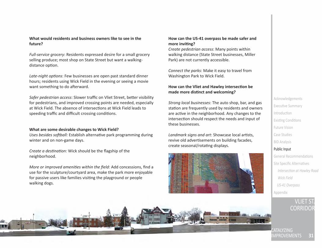
Landmark signs and art: Showcase local ar sts, revive old adver sements on building facades, create seasonal/rota ng displays.
SUMMARY: Public Input and Corridor Iden tyIden ty and Branding
IDENTITY BACKGROUNDOne major goal of the public input process was determining the corridor iden ty, as the star ng point for the branding and marke ng process. Several strengths and assets of the neighborhood were iden fi ed that could inform the development of a concrete and marketable iden ty for the corridor. These assets can be dis lled down to the following three concepts:
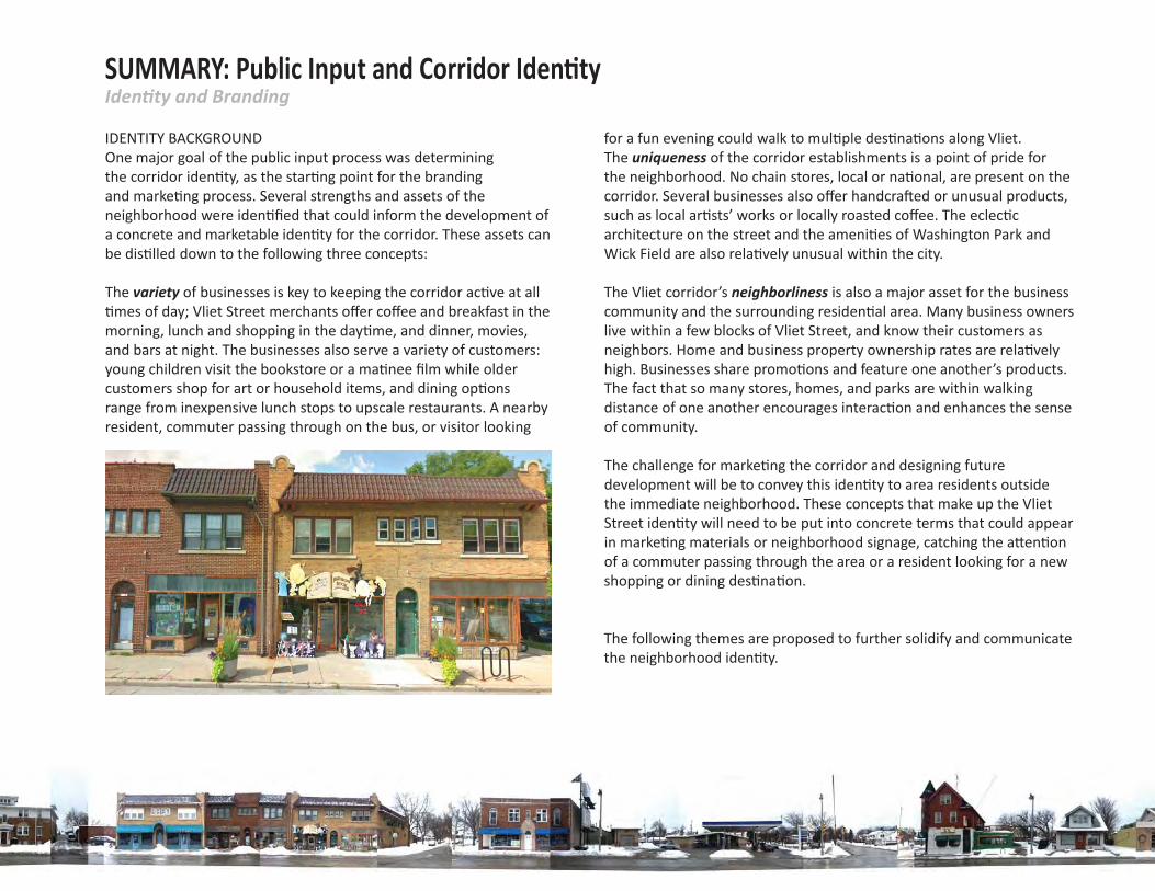
The variety of businesses is key to keeping the corridor ac ve at all mes of day; Vliet Street merchants off er coff ee and breakfast in the
morning, lunch and shopping in the day me, and dinner, movies, and bars at night. The businesses also serve a variety of customers: young children visit the bookstore or a ma nee fi lm while older customers shop for art or household items, and dining op ons range from inexpensive lunch stops to upscale restaurants. A nearby resident, commuter passing through on the bus, or visitor looking
for a fun evening could walk to mul ple des na ons along Vliet.The uniqueness of the corridor establishments is a point of pride for the neighborhood. No chain stores, local or na onal, are present on the corridor. Several businesses also off er handcra ed or unusual products, such as local ar sts’ works or locally roasted coff ee. The eclec c architecture on the street and the ameni es of Washington Park and Wick Field are also rela vely unusual within the city.
The Vliet corridor’s neighborliness is also a major asset for the business community and the surrounding residen al area. Many business owners live within a few blocks of Vliet Street, and know their customers as neighbors. Home and business property ownership rates are rela vely high. Businesses share promo ons and feature one another’s products. The fact that so many stores, homes, and parks are within walking distance of one another encourages interac on and enhances the sense of community.
The challenge for marke ng the corridor and designing future development will be to convey this iden ty to area residents outside the immediate neighborhood. These concepts that make up the Vliet Street iden ty will need to be put into concrete terms that could appear in marke ng materials or neighborhood signage, catching the a en on of a commuter passing through the area or a resident looking for a new shopping or dining des na on.
The following themes are proposed to further solidify and communicate the neighborhood iden ty.
33
VLIET ST.CORRIDOR
CATALYZINGIMPROVEMENTS
Acknowledgements
Execu ve Summary
Introduc on
Exis ng Condi ons
Future Vision
Case Studies
BID Analysis
Public Input
General Recommenda ons
Site Specifi c Alterna ves
Intersec on at Hawley Road
Wick Field
US-41 Overpass
Appendix
ALTERNATIVE A: ARTS DISTRICT Several local business owners view Vliet Street as an arts district, and have proposed this as a marke ng concept. This theme would highlight local ar sts and the number of arts businesses located along the corridor. New development or BID-fi nanced streetscape improvements along the corridor could incorporate murals, sculpture and signage designed by local ar sts. Marke ng materials using this theme would emphasize the concentra on of unique, locally-owned arts businesses in the area, and recommend gallery visits or events like the Westside Artwalk. Poten al drawbacks of this approach include diffi culty publicizing non-arts businesses and events, and compe on with other arts districts in the area.
ALTERNATIVE B: SMALL TOWN / MAIN STREET The corridor could also be conceptualized as a small town main street within the city of Milwaukee. This theme draws on the high level of local ownership, walkability, and uniqueness of the businesses on Vliet. Concepts like “your local bar” and “your neighbor’s shop” would be used in marke ng materials. This theme would also highlight local community events in Wick Field, par cularly if some of the park improvements and year-round uses this report proposes are put in place. Design of new buildings or streetscape improvements would use tradi onal materials like wood and brick, and emphasize the area’s historic character. Wayfi nding signage would highlight the small scale of the neighborhood and the variety of des na ons within walking distance.
ALTERNATIVE C: BEST OF MILWAUKEE / SOMETHING FOR EVERYONEBased on the variety of local des na ons and reputa on of successful local businesses, this theme promotes the corridor as a place where any visitor can fi nd something they will enjoy. The business associa on could use this concept to market regular promo ons like art gallery nights, date nights, children’s days, etc. This theme has the advantage of being marketable to a wide range of demographics and could work well to draw customers from around the region. One poten al drawback, however, is that this theme lacks a visual component and is less concrete than others.
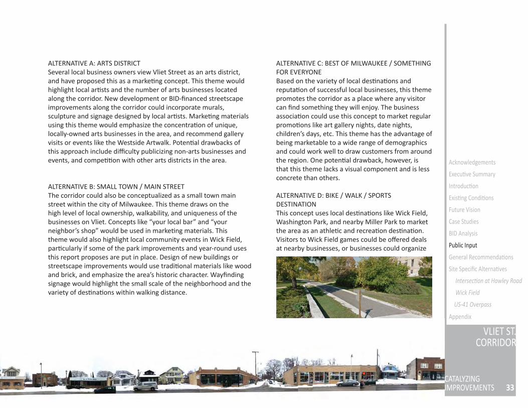
ALTERNATIVE D: BIKE / WALK / SPORTS DESTINATIONThis concept uses local des na ons like Wick Field, Washington Park, and nearby Miller Park to market the area as an athle c and recrea on des na on. Visitors to Wick Field games could be off ered deals at nearby businesses, or businesses could organize
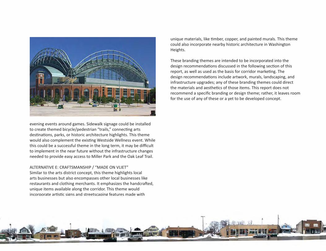
evening events around games. Sidewalk signage could be installed to create themed bicycle/pedestrian “trails,” connec ng arts des na ons, parks, or historic architecture highlights. This theme would also complement the exis ng Westside Wellness event. While this could be a successful theme in the long term, it may be diffi cult to implement in the near future without the infrastructure changes needed to provide easy access to Miller Park and the Oak Leaf Trail.
ALTERNATIVE E: CRAFTSMANSHIP / “MADE ON VLIET”Similar to the arts district concept, this theme highlights local arts businesses but also encompasses other local businesses like restaurants and clothing merchants. It emphasizes the handcra ed, unique items available along the corridor. This theme would incorporate ar s c signs and streetscaping features made with
unique materials, like mber, copper, and painted murals. This theme could also incorporate nearby historic architecture in Washington Heights.
These branding themes are intended to be incorporated into the design recommenda ons discussed in the following sec on of this report, as well as used as the basis for corridor marke ng. The design recommenda ons include artwork, murals, landscaping, and infrastructure upgrades; any of these branding themes could direct the materials and aesthe cs of those items. This report does not recommend a specifi c branding or design theme; rather, it leaves room for the use of any of these or a yet to be developed concept.
35
VLIET ST.CORRIDOR
CATALYZINGIMPROVEMENTS
Acknowledgements
Execu ve Summary
Introduc on
Exis ng Condi ons
Future Vision
Case Studies
BID Analysis
Public Input
General Recommenda ons
Site Specifi c Alterna ves
Intersec on at Hawley Road
Wick Field
US-41 Overpass
Appendix
RECOMMENDATIONSIntroduc on
The following recommenda ons are proposed for development of a neighborhood iden ty for the West Vliet Street corridor, as well as future land development and infrastructure improvements. Within each category, a range of poten al ac ons was iden fi ed. Each category of recommenda ons includes an ambi ous long-term vision for the corridor, assuming the availability of funding and city approval. The recommenda ons also include more moderate changes that can be implemented with limited me and money, through the local BID (if formed) or grant funding. The alterna ves presented within each category are not mutually exclusive; rather, they represent a range of me frames and feasibility.
The recommenda ons draw from the iden ty and branding concepts discussed earlier in this report. Signage, art installa ons, and event programming discussed within these recommenda ons can be designed using any of the proposed marke ng themes, and are based on the fundamental corridor iden ty of variety, uniqueness, and neighborliness. Recommenda ons also considered available funding sources, poten al to generate revenue, and poten al to serve as catalysts for future development or programs. In addi on, the recommenda ons priori zed fl exibility, allowing for varying funding levels, gradual implementa on, and changing preferences over me.
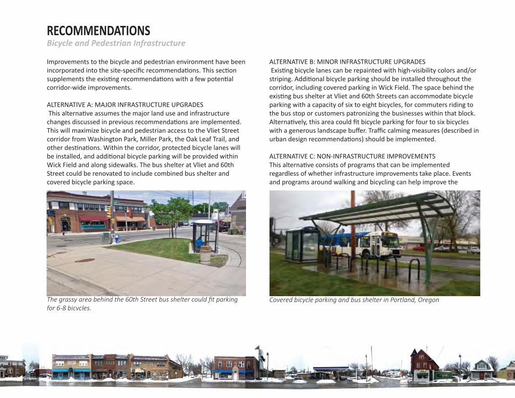
RECOMMENDATIONSBicycle and Pedestrian Infrastructure
Improvements to the bicycle and pedestrian environment have been incorporated into the site-specifi c recommenda ons. This sec on supplements the exis ng recommenda ons with a few poten al corridor-wide improvements.
ALTERNATIVE A: MAJOR INFRASTRUCTURE UPGRADES This alterna ve assumes the major land use and infrastructure changes discussed in previous recommenda ons are implemented. This will maximize bicycle and pedestrian access to the Vliet Street corridor from Washington Park, Miller Park, the Oak Leaf Trail, and other des na ons. Within the corridor, protected bicycle lanes will be installed, and addi onal bicycle parking will be provided within Wick Field and along sidewalks. The bus shelter at Vliet and 60th Street could be renovated to include combined bus shelter and covered bicycle parking space.
ALTERNATIVE B: MINOR INFRASTRUCTURE UPGRADES Exis ng bicycle lanes can be repainted with high-visibility colors and/or striping. Addi onal bicycle parking should be installed throughout the corridor, including covered parking in Wick Field. The space behind the exis ng bus shelter at Vliet and 60th Streets can accommodate bicycle parking with a capacity of six to eight bicycles, for commuters riding to the bus stop or customers patronizing the businesses within that block. Alterna vely, this area could fi t bicycle parking for four to six bicycles with a generous landscape buff er. Traffi c calming measures (described in urban design recommenda ons) should be implemented.
ALTERNATIVE C: NON-INFRASTRUCTURE IMPROVEMENTSThis alterna ve consists of programs that can be implemented regardless of whether infrastructure improvements take place. Events and programs around walking and bicycling can help improve the
The grassy area behind the 60th Street bus shelter could fi t parking for 6-8 bicycles.
Covered bicycle parking and bus shelter in Portland, Oregon
37
VLIET ST.CORRIDOR
CATALYZINGIMPROVEMENTS
Acknowledgements
Execu ve Summary
Introduc on
Exis ng Condi ons
Future Vision
Case Studies
BID Analysis
Public Input
General Recommenda ons
Site Specifi c Alterna ves
Intersec on at Hawley Road
Wick Field
US-41 Overpass
Appendix
environment for non-motorized transporta on without major infrastructure changes.
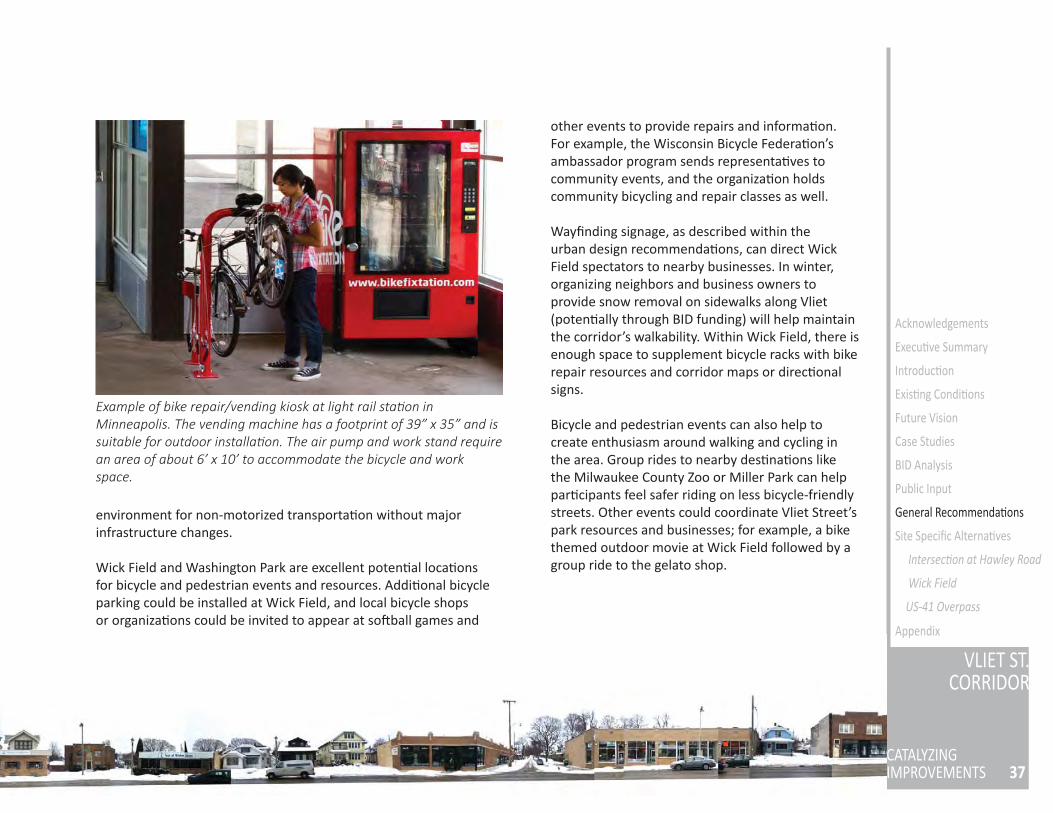
Wick Field and Washington Park are excellent poten al loca ons for bicycle and pedestrian events and resources. Addi onal bicycle parking could be installed at Wick Field, and local bicycle shops or organiza ons could be invited to appear at so ball games and
other events to provide repairs and informa on. For example, the Wisconsin Bicycle Federa on’s ambassador program sends representa ves to community events, and the organiza on holds community bicycling and repair classes as well.
Wayfi nding signage, as described within the urban design recommenda ons, can direct Wick Field spectators to nearby businesses. In winter, organizing neighbors and business owners to provide snow removal on sidewalks along Vliet (poten ally through BID funding) will help maintain the corridor’s walkability. Within Wick Field, there is enough space to supplement bicycle racks with bike repair resources and corridor maps or direc onal signs.
Bicycle and pedestrian events can also help to create enthusiasm around walking and cycling in the area. Group rides to nearby des na ons like the Milwaukee County Zoo or Miller Park can help par cipants feel safer riding on less bicycle-friendly streets. Other events could coordinate Vliet Street’s park resources and businesses; for example, a bike themed outdoor movie at Wick Field followed by a group ride to the gelato shop.
Example of bike repair/vending kiosk at light rail sta on in Minneapolis. The vending machine has a footprint of 39” x 35” and is suitable for outdoor installa on. The air pump and work stand require an area of about 6’ x 10’ to accommodate the bicycle and work space.
RECOMMENDATIONSOverall Urban Design
The following alterna ves are proposed for general urban design improvements to the Vliet Street corridor. These are not intended to be mutually exclusive; rather, they can func on as individual elements of a holis c plan, or could be pursued in series as funding becomes available.
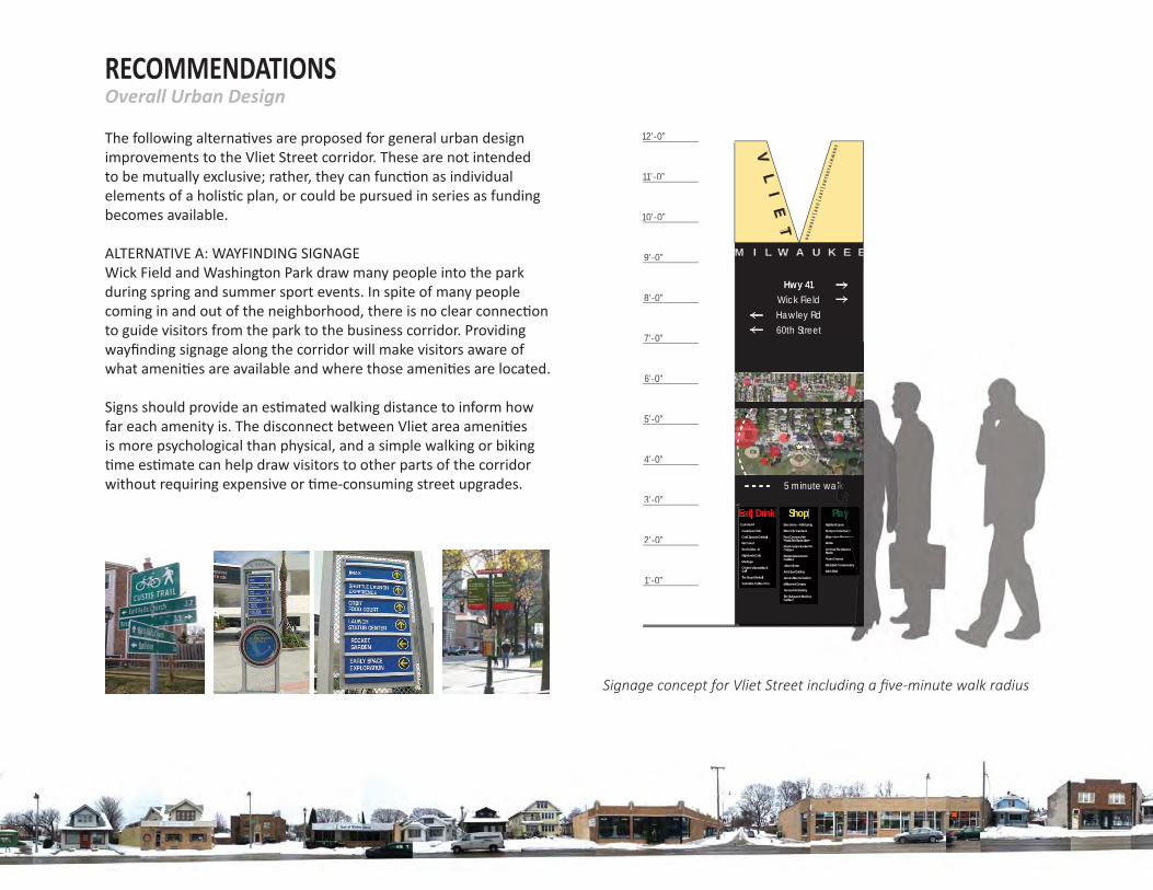
ALTERNATIVE A: WAYFINDING SIGNAGE Wick Field and Washington Park draw many people into the park during spring and summer sport events. In spite of many people coming in and out of the neighborhood, there is no clear connec on to guide visitors from the park to the business corridor. Providing wayfi nding signage along the corridor will make visitors aware of what ameni es are available and where those ameni es are located.
Signs should provide an es mated walking distance to inform how far each amenity is. The disconnect between Vliet area ameni es is more psychological than physical, and a simple walking or biking me es mate can help draw visitors to other parts of the corridor
without requiring expensive or me-consuming street upgrades.
60th Street
Wick FieldHawley Rd
Hwy 41
Cafe Perrin
Caradaro Club
Cold Spoons Gelato
Eat Cake!
Fred’s Drive -In
Highlands Cafe
Meritage
O’brien’s Sports Bar & Grill
The Soup Market
Valentine Coffee CCo.
Eat|Drink Barcelona - Artful Living
Brew City Gardens
Four Corners of the World Fair Trade Store
Rainbow Booksellers for Children
Roots Underground Outfitters
Urban Sense
Art & Soul Gallery
James Steeno Gallery
Milkweed Designs
Nomad Art Gallery
The Salvaged Studio & Galllery
ShopHighland Lanes
Kempo-Goju Karate
Milwaukee Recreation
MUSA
On Your Toes Dance Studio
Times Cinema
West End Conservatory
Wick Field
Play
12’-0”
Hwy 41
11’-0”
10’-0”
9’-0”
8’-0”
7’-0”
6’-0”
5’-0”
4’-0”
3’-0”
2’-0”
1’-0”
M I L W A U K E E
VL
IE
T
BU
SI N
ES
S |R
EC
| AR
T |E
NT E
RT A
I NM
EN
T
5 minute walk
Cafe Perrin
Caradaro Club
Cold Spoons Gelato
Eat Cake!
Fred’s Drive -In
Highlands Cafe
Meritage
O’brien’s Sports Bar & Grill
The Soup Market
Valentine Coffee CCo.
Eat|Drink Barcelona - Artful Living
Brew City Gardens
Four Corners of the World Fair Trade Store
Rainbow Booksellers for Children
Roots Underground Outfitters
Urban Sense
Art & Soul Gallery
James Steeno Gallery
Milkweed Designs
Nomad Art Gallery
The Salvaged Studio & Galllery
ShopHighland Lanes
Kempo-Goju Karaaaateaaaaaaa
Milwaukee Recreatattiontittiatatatattt
MUSA
On Your Toes Dance Studio
Times Cinema
West End Conservatory
Wick Field
Playyyyyyyyyyyyyyyyyyyy
5 minute wallllllllllllllllkkkkkkk
Signage concept for Vliet Street including a fi ve-minute walk radius
39
VLIET ST.CORRIDOR
CATALYZINGIMPROVEMENTS
Acknowledgements
Execu ve Summary
Introduc on
Exis ng Condi ons
Future Vision
Case Studies
BID Analysis
Public Input
General Recommenda ons
Site Specifi c Alterna ves
Intersec on at Hawley Road
Wick Field
US-41 Overpass
Appendix
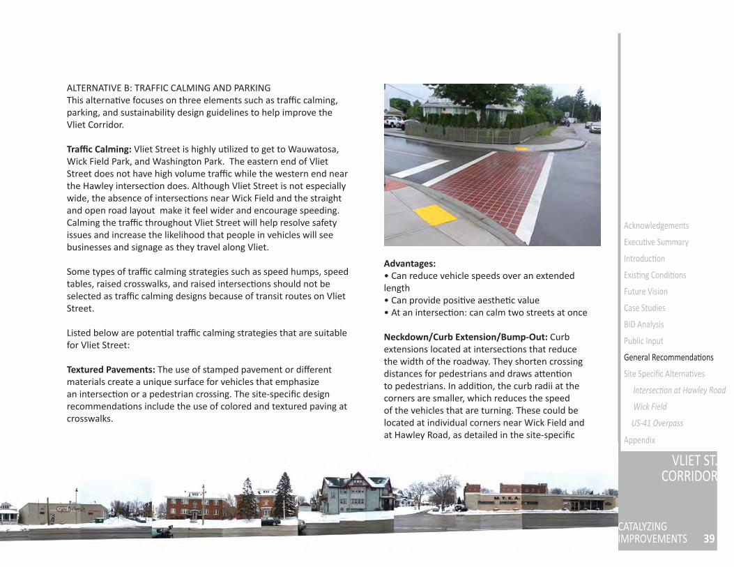
ALTERNATIVE B: TRAFFIC CALMING AND PARKING This alterna ve focuses on three elements such as traffi c calming, parking, and sustainability design guidelines to help improve the Vliet Corridor.
Traffi c Calming: Vliet Street is highly u lized to get to Wauwatosa, Wick Field Park, and Washington Park. The eastern end of Vliet Street does not have high volume traffi c while the western end near the Hawley intersec on does. Although Vliet Street is not especially wide, the absence of intersec ons near Wick Field and the straight and open road layout make it feel wider and encourage speeding. Calming the traffi c throughout Vliet Street will help resolve safety issues and increase the likelihood that people in vehicles will see businesses and signage as they travel along Vliet.
Some types of traffi c calming strategies such as speed humps, speed tables, raised crosswalks, and raised intersec ons should not be selected as traffi c calming designs because of transit routes on Vliet Street.
Listed below are poten al traffi c calming strategies that are suitable for Vliet Street:
Textured Pavements: The use of stamped pavement or diff erent materials create a unique surface for vehicles that emphasize an intersec on or a pedestrian crossing. The site-specifi c design recommenda ons include the use of colored and textured paving at crosswalks.
Advantages:• Can reduce vehicle speeds over an extended length• Can provide posi ve aesthe c value• At an intersec on: can calm two streets at once
Neckdown/Curb Extension/Bump-Out: Curb extensions located at intersec ons that reduce the width of the roadway. They shorten crossing distances for pedestrians and draws a en on to pedestrians. In addi on, the curb radii at the corners are smaller, which reduces the speed of the vehicles that are turning. These could be located at individual corners near Wick Field and at Hawley Road, as detailed in the site-specifi c
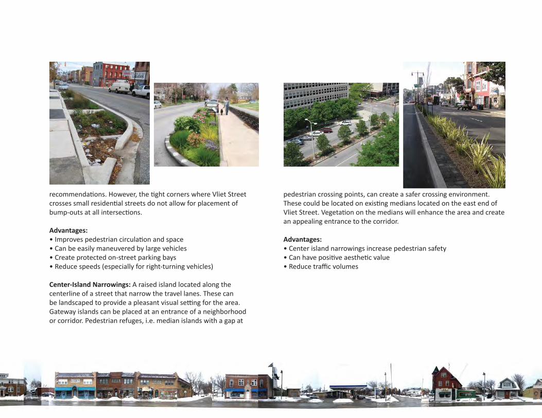
recommenda ons. However, the ght corners where Vliet Street crosses small residen al streets do not allow for placement of bump-outs at all intersec ons.
Advantages:• Improves pedestrian circula on and space• Can be easily maneuvered by large vehicles • Create protected on-street parking bays• Reduce speeds (especially for right-turning vehicles)
Center-Island Narrowings: A raised island located along the centerline of a street that narrow the travel lanes. These can be landscaped to provide a pleasant visual se ng for the area. Gateway islands can be placed at an entrance of a neighborhood or corridor. Pedestrian refuges, i.e. median islands with a gap at
pedestrian crossing points, can create a safer crossing environment. These could be located on exis ng medians located on the east end of Vliet Street. Vegeta on on the medians will enhance the area and create an appealing entrance to the corridor.
Advantages:• Center island narrowings increase pedestrian safety• Can have posi ve aesthe c value• Reduce traffi c volumes
41
VLIET ST.CORRIDOR
CATALYZINGIMPROVEMENTS
Acknowledgements
Execu ve Summary
Introduc on
Exis ng Condi ons
Future Vision
Case Studies
BID Analysis
Public Input
Site Specifi c Alterna ves
Intersec on at Hawley Road
Wick Field
US-41 Overpass
Appendix
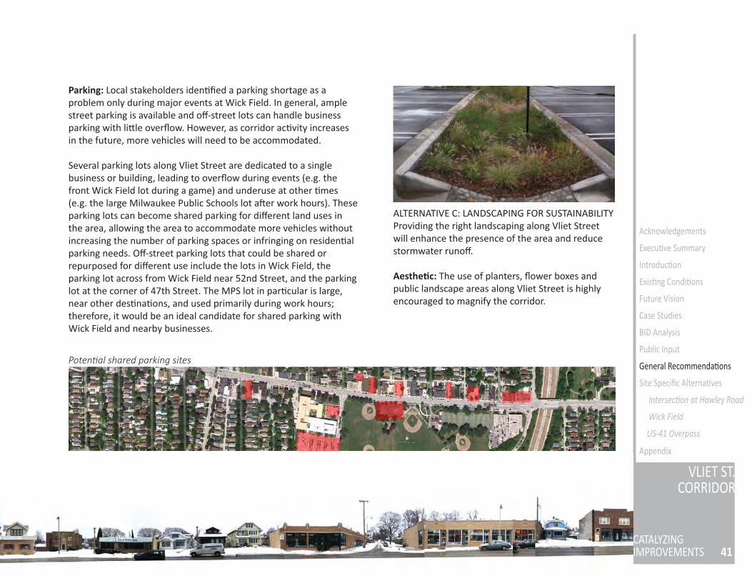
Parking: Local stakeholders iden fi ed a parking shortage as a problem only during major events at Wick Field. In general, ample street parking is available and off -street lots can handle business parking with li le overfl ow. However, as corridor ac vity increases in the future, more vehicles will need to be accommodated.
Several parking lots along Vliet Street are dedicated to a single business or building, leading to overfl ow during events (e.g. the front Wick Field lot during a game) and underuse at other mes (e.g. the large Milwaukee Public Schools lot a er work hours). These parking lots can become shared parking for diff erent land uses in the area, allowing the area to accommodate more vehicles without increasing the number of parking spaces or infringing on residen al parking needs. Off -street parking lots that could be shared or repurposed for diff erent use include the lots in Wick Field, the parking lot across from Wick Field near 52nd Street, and the parking lot at the corner of 47th Street. The MPS lot in par cular is large, near other des na ons, and used primarily during work hours; therefore, it would be an ideal candidate for shared parking with Wick Field and nearby businesses.
ALTERNATIVE C: LANDSCAPING FOR SUSTAINABILITY Providing the right landscaping along Vliet Street will enhance the presence of the area and reduce stormwater runoff .
Aesthe c: The use of planters, fl ower boxes and public landscape areas along Vliet Street is highly encouraged to magnify the corridor.
Poten al shared parking sites General Recommenda ons
Sustainability: Sustainably designed landscaping can enhance the stormwater performance as well as the aesthe c environment of Vliet Street. Rain gardens and bioswales can be placed throughout Vliet Street, especially by the bus stop on the Hawley intersec on, the edge of Wick Field, and medians on the east side of Vliet Street. In addi on, because the Milwaukee Public Schools headquarters has a large parking lot, future modifi ca on or redevelopment of the parking lot should consider using pervious materials so rain water infi ltrates into the ground rather than running into the sewer system. If applicable, any new parking lots should also include medians where trees and plants can be planted as well to reduce water runoff .
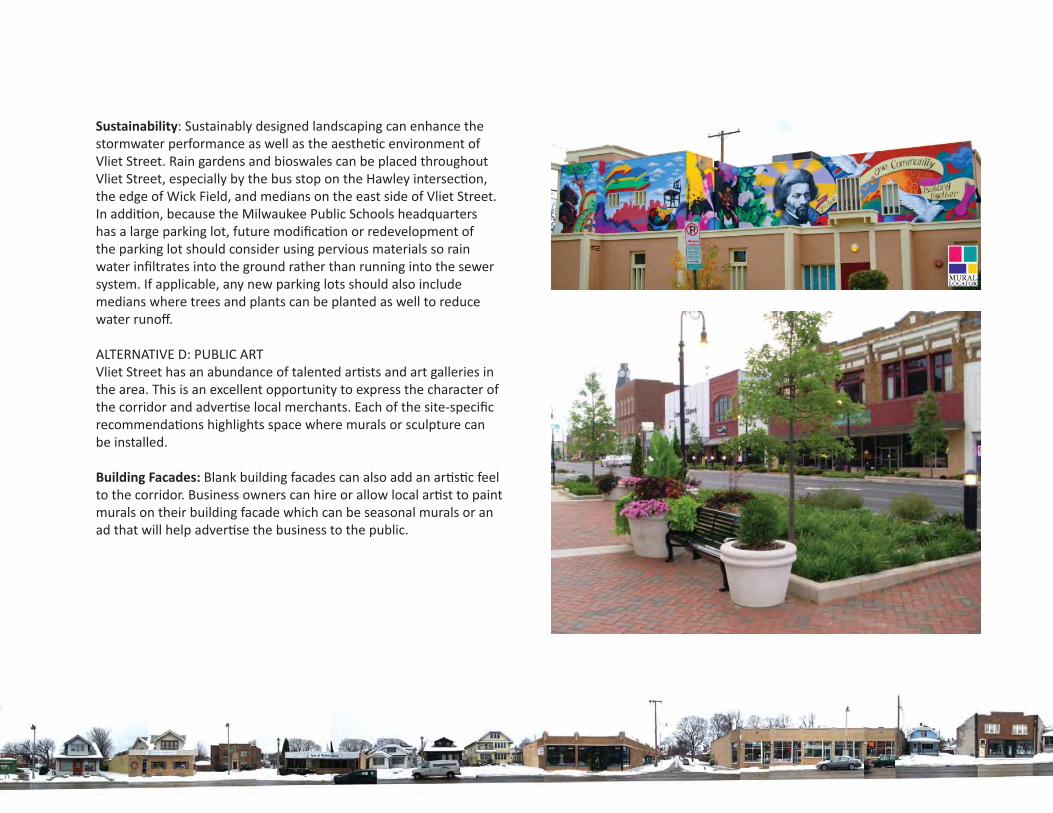
ALTERNATIVE D: PUBLIC ARTVliet Street has an abundance of talented ar sts and art galleries in the area. This is an excellent opportunity to express the character of the corridor and adver se local merchants. Each of the site-specifi c recommenda ons highlights space where murals or sculpture can be installed.
Building Facades: Blank building facades can also add an ar s c feel to the corridor. Business owners can hire or allow local ar st to paint murals on their building facade which can be seasonal murals or an ad that will help adver se the business to the public.
43
VLIET ST.CORRIDOR
CATALYZINGIMPROVEMENTS
Acknowledgements
Execu ve Summary
Introduc on
Exis ng Condi ons
Future Vision
Case Studies
BID Analysis
Public Input
Site Specifi c Alterna ves
Intersec on at Hawley Road
Wick Field
US-41 Overpass
Appendix
RECOMMENDATIONSFirst Steps for Implementa on
While many of the recommenda ons discussed earlier in this report will require a substan al investment of me and money, several opportuni es exist for the City of Milwaukee and local businesses to begin improving the corridor in the short term and with exis ng resources. The following components of our recommenda ons are proposed as high-priority, low-cost enhancements.
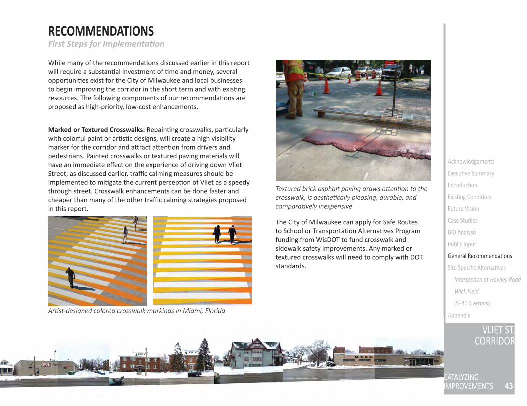
Marked or Textured Crosswalks: Repain ng crosswalks, par cularly with colorful paint or ar s c designs, will create a high visibility marker for the corridor and a ract a en on from drivers and pedestrians. Painted crosswalks or textured paving materials will have an immediate eff ect on the experience of driving down Vliet Street; as discussed earlier, traffi c calming measures should be implemented to mi gate the current percep on of Vliet as a speedy through street. Crosswalk enhancements can be done faster and cheaper than many of the other traffi c calming strategies proposed in this report.
The City of Milwaukee can apply for Safe Routes to School or Transporta on Alterna ves Program funding from WisDOT to fund crosswalk and sidewalk safety improvements. Any marked or textured crosswalks will need to comply with DOT standards.
Ar st-designed colored crosswalk markings in Miami, Florida
Textured brick asphalt paving draws a en on to the crosswalk, is aesthe cally pleasing, durable, and compara vely inexpensive
General Recommenda ons
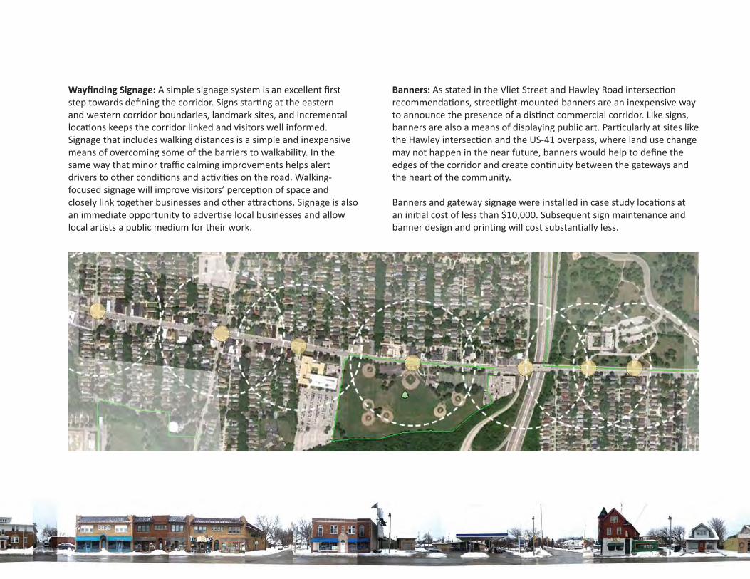
Wayfi nding Signage: A simple signage system is an excellent fi rst step towards defi ning the corridor. Signs star ng at the eastern and western corridor boundaries, landmark sites, and incremental loca ons keeps the corridor linked and visitors well informed. Signage that includes walking distances is a simple and inexpensive means of overcoming some of the barriers to walkability. In the same way that minor traffi c calming improvements helps alert drivers to other condi ons and ac vi es on the road. Walking-focused signage will improve visitors’ percep on of space and closely link together businesses and other a rac ons. Signage is also an immediate opportunity to adver se local businesses and allow local ar sts a public medium for their work.
Banners: As stated in the Vliet Street and Hawley Road intersec on recommenda ons, streetlight-mounted banners are an inexpensive way to announce the presence of a dis nct commercial corridor. Like signs, banners are also a means of displaying public art. Par cularly at sites like the Hawley intersec on and the US-41 overpass, where land use change may not happen in the near future, banners would help to defi ne the edges of the corridor and create con nuity between the gateways and the heart of the community.
Banners and gateway signage were installed in case study loca ons at an ini al cost of less than $10,000. Subsequent sign maintenance and banner design and prin ng will cost substan ally less.
Proposed wayfi nding signage and banner loca ons
45
VLIET ST.CORRIDOR
CATALYZINGIMPROVEMENTS
Acknowledgements
Execu ve Summary
Introduc on
Exis ng Condi ons
Future Vision
Case Studies
BID Analysis
Public Input
General Recommenda ons
Site Specifi c Alterna ves
Intersec on at Hawley Road
Wick Field
US-41 Overpass
Appendix
SITE SPECIFIC ALTERNATIVESSites for Redevelopment
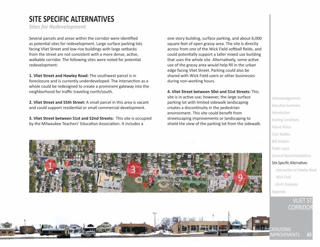
Several parcels and areas within the corridor were iden fi ed as poten al sites for redevelopment. Large surface parking lots facing Vliet Street and low-rise buildings with large setbacks from the street are not consistent with a more dense, ac ve, walkable corridor. The following sites were noted for poten al redevelopment:
1. Vliet Street and Hawley Road: The southwest parcel is in foreclosure and is currently underdeveloped. The intersec on as a whole could be redesigned to create a prominent gateway into the neighborhood for traffi c traveling north/south.
2. Vliet Street and 55th Street: A small parcel in this area is vacant and could support residen al or small commercial development.
3. Vliet Street between 51st and 52nd Streets: This site is occupied by the Milwaukee Teachers’ Educa on Associa on. It includes a
one-story building, surface parking, and about 6,000 square feet of open grassy area. The site is directly across from one of the Wick Field so ball fi elds, and could poten ally support a taller mixed use building that uses the whole site. Alterna vely, some ac ve use of the grassy area would help fi ll in the urban edge facing Vliet Street. Parking could also be shared with Wick Field users or other businesses during non-working hours.
4. Vliet Street between 50st and 51st Streets: This site is in ac ve use; however, the large surface parking lot with limited sidewalk landscaping creates a discon nuity in the pedestrian environment. This site could benefi t from streetscaping improvements or landscaping to shield the view of the parking lot from the sidewalk.
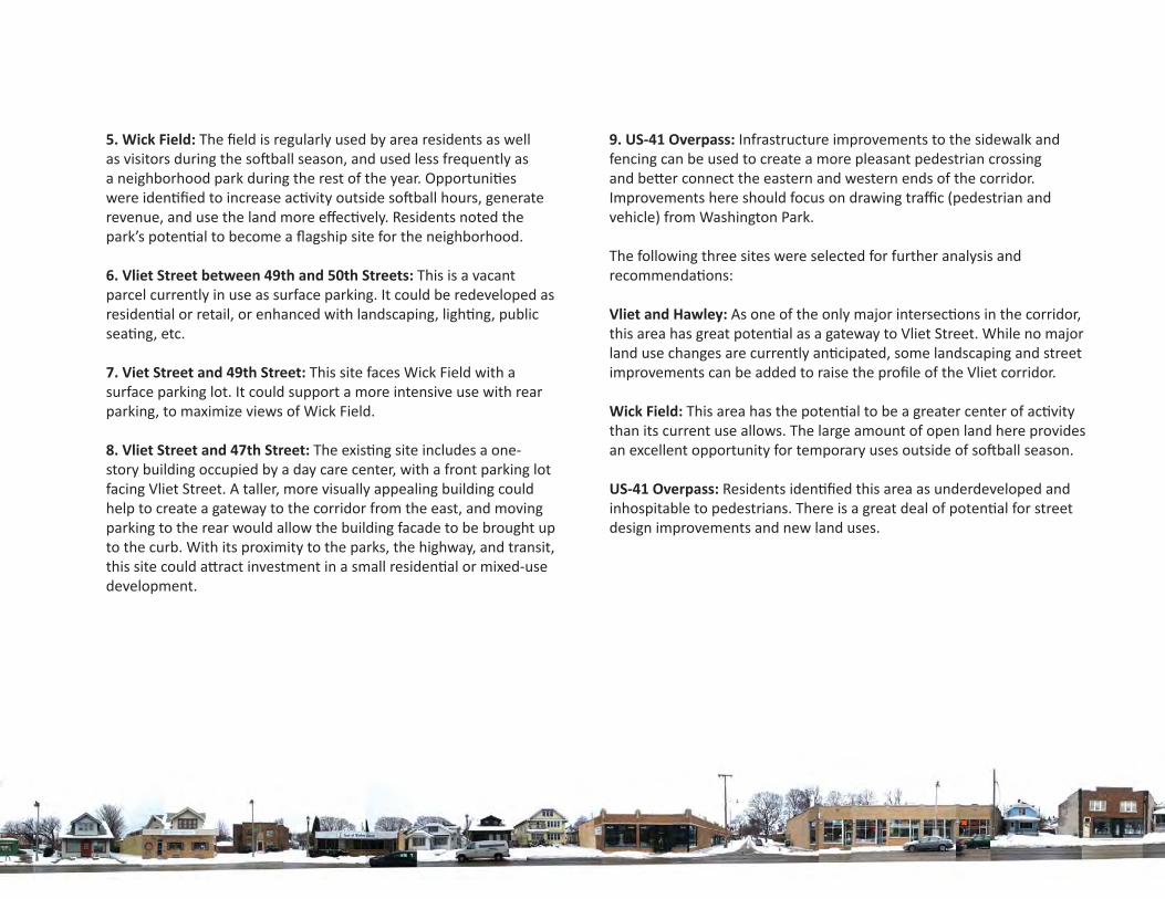
5. Wick Field: The fi eld is regularly used by area residents as well as visitors during the so ball season, and used less frequently as a neighborhood park during the rest of the year. Opportuni es were iden fi ed to increase ac vity outside so ball hours, generate revenue, and use the land more eff ec vely. Residents noted the park’s poten al to become a fl agship site for the neighborhood.
6. Vliet Street between 49th and 50th Streets: This is a vacant parcel currently in use as surface parking. It could be redeveloped as residen al or retail, or enhanced with landscaping, ligh ng, public sea ng, etc.
7. Viet Street and 49th Street: This site faces Wick Field with a surface parking lot. It could support a more intensive use with rear parking, to maximize views of Wick Field.
8. Vliet Street and 47th Street: The exis ng site includes a one-story building occupied by a day care center, with a front parking lot facing Vliet Street. A taller, more visually appealing building could help to create a gateway to the corridor from the east, and moving parking to the rear would allow the building facade to be brought up to the curb. With its proximity to the parks, the highway, and transit, this site could a ract investment in a small residen al or mixed-use development.
9. US-41 Overpass: Infrastructure improvements to the sidewalk and fencing can be used to create a more pleasant pedestrian crossing and be er connect the eastern and western ends of the corridor. Improvements here should focus on drawing traffi c (pedestrian and vehicle) from Washington Park.
The following three sites were selected for further analysis and recommenda ons:
Vliet and Hawley: As one of the only major intersec ons in the corridor, this area has great poten al as a gateway to Vliet Street. While no major land use changes are currently an cipated, some landscaping and street improvements can be added to raise the profi le of the Vliet corridor.
Wick Field: This area has the poten al to be a greater center of ac vity than its current use allows. The large amount of open land here provides an excellent opportunity for temporary uses outside of so ball season.
US-41 Overpass: Residents iden fi ed this area as underdeveloped and inhospitable to pedestrians. There is a great deal of poten al for street design improvements and new land uses.
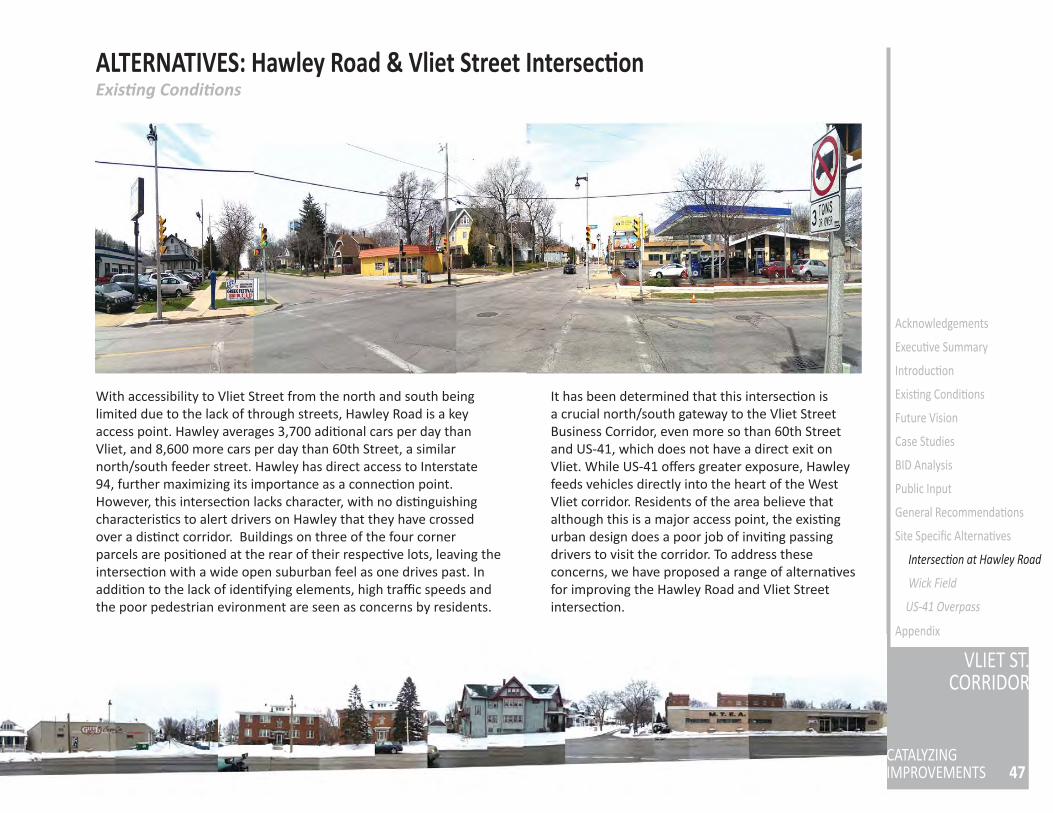
47
VLIET ST.CORRIDOR
CATALYZINGIMPROVEMENTS
Acknowledgements
Execu ve Summary
Introduc on
Exis ng Condi ons
Future Vision
Case Studies
BID Analysis
Public Input
General Recommenda ons
Site Specifi c Alterna ves
Intersec on at Hawley Road
Wick Field
US-41 Overpass
Appendix
ALTERNATIVES: Hawley Road & Vliet Street Intersec onExis ng Condi ons
With accessibility to Vliet Street from the north and south being limited due to the lack of through streets, Hawley Road is a key access point. Hawley averages 3,700 adi onal cars per day than Vliet, and 8,600 more cars per day than 60th Street, a similar north/south feeder street. Hawley has direct access to Interstate 94, further maximizing its importance as a connec on point. However, this intersec on lacks character, with no dis nguishing characteris cs to alert drivers on Hawley that they have crossed over a dis nct corridor. Buildings on three of the four corner parcels are posi oned at the rear of their respec ve lots, leaving the intersec on with a wide open suburban feel as one drives past. In addi on to the lack of iden fying elements, high traffi c speeds and the poor pedestrian evironment are seen as concerns by residents.
It has been determined that this intersec on is a crucial north/south gateway to the Vliet Street Business Corridor, even more so than 60th Street and US-41, which does not have a direct exit on Vliet. While US-41 off ers greater exposure, Hawley feeds vehicles directly into the heart of the West Vliet corridor. Residents of the area believe that although this is a major access point, the exis ng urban design does a poor job of invi ng passing drivers to visit the corridor. To address these concerns, we have proposed a range of alterna ves for improving the Hawley Road and Vliet Street intersec on.
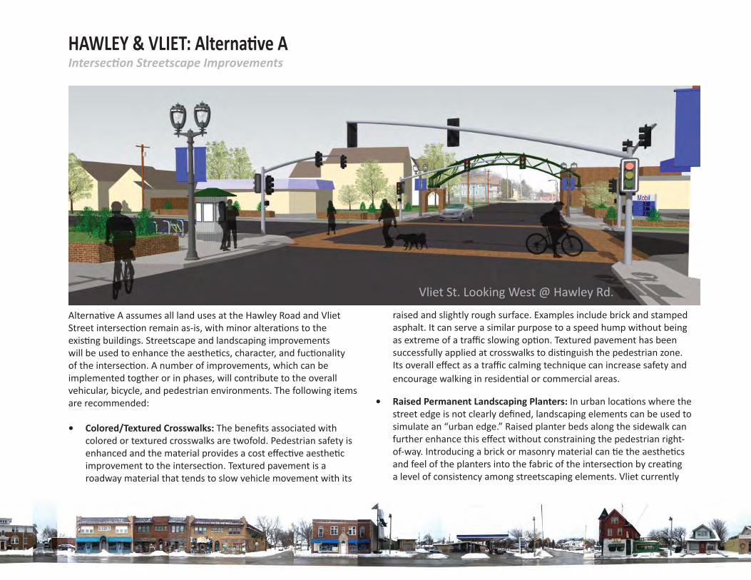
HAWLEY & VLIET: Alterna ve AIntersec on Streetscape Improvements
• Raised Permanent Landscaping Planters: In urban loca ons where the street edge is not clearly defi ned, landscaping elements can be used to simulate an “urban edge.” Raised planter beds along the sidewalk can further enhance this eff ect without constraining the pedestrian right-of-way. Introducing a brick or masonry material can e the aesthe cs and feel of the planters into the fabric of the intersec on by crea ng a level of consistency among streetscaping elements. Vliet currently
Vliet St. Looking West @ Hawley Rd.
Alterna ve A assumes all land uses at the Hawley Road and Vliet Street intersec on remain as-is, with minor altera ons to the exis ng buildings. Streetscape and landscaping improvements will be used to enhance the aesthe cs, character, and fuc onality of the intersec on. A number of improvements, which can be implemented togther or in phases, will contribute to the overall vehicular, bicycle, and pedestrian environments. The following items are recommended:
• Colored/Textured Crosswalks: The benefi ts associated with colored or textured crosswalks are twofold. Pedestrian safety is enhanced and the material provides a cost eff ec ve aesthe c improvement to the intersec on. Textured pavement is a roadway material that tends to slow vehicle movement with its
raised and slightly rough surface. Examples include brick and stamped asphalt. It can serve a similar purpose to a speed hump without being as extreme of a traffi c slowing op on. Textured pavement has been successfully applied at crosswalks to dis nguish the pedestrian zone. Its overall eff ect as a traffi c calming technique can increase safety and encourage walking in residen al or commercial areas.
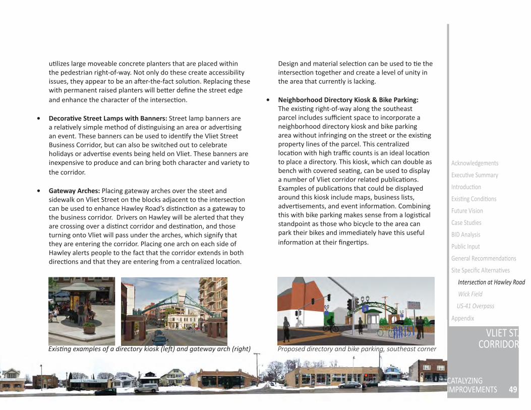
49
VLIET ST.CORRIDOR
CATALYZINGIMPROVEMENTS
Acknowledgements
Execu ve Summary
Introduc on
Exis ng Condi ons
Future Vision
Case Studies
BID Analysis
Public Input
General Recommenda ons
Site Specifi c Alterna ves
Wick Field
US-41 Overpass
Appendix
Exis ng examples of a directory kiosk (le ) and gateway arch (right) Proposed directory and bike parking, southeast corner
u lizes large moveable concrete planters that are placed within the pedestrian right-of-way. Not only do these create accessibility issues, they appear to be an a er-the-fact solu on. Replacing these with permanent raised planters will be er defi ne the street edge and enhance the character of the intersec on.
• Decora ve Street Lamps with Banners: Street lamp banners are a rela vely simple method of dis nguising an area or adver sing an event. These banners can be used to iden fy the Vliet Street Business Corridor, but can also be switched out to celebrate holidays or adver se events being held on Vliet. These banners are inexpensive to produce and can bring both character and variety to the corridor.
• Gateway Arches: Placing gateway arches over the steet and sidewalk on Vliet Street on the blocks adjacent to the intersec on can be used to enhance Hawley Road’s dis nc on as a gateway to the business corridor. Drivers on Hawley will be alerted that they are crossing over a dis nct corridor and des na on, and those turning onto Vliet will pass under the arches, which signify that they are entering the corridor. Placing one arch on each side of Hawley alerts people to the fact that the corridor extends in both direc ons and that they are entering from a centralized loca on.
Design and material selec on can be used to e the intersec on together and create a level of unity in the area that currently is lacking.
• Neighborhood Directory Kiosk & Bike Parking: The exis ng right-of-way along the southeast parcel includes suffi cient space to incorporate a neighborhood directory kiosk and bike parking area without infringing on the street or the exis ng property lines of the parcel. This centralized loca on with high traffi c counts is an ideal loca on to place a directory. This kiosk, which can double as bench with covered sea ng, can be used to display a number of Vliet corridor related publica ons. Examples of publica ons that could be displayed around this kiosk include maps, business lists, adver sements, and event informa on. Combining this with bike parking makes sense from a logis cal standpoint as those who bicycle to the area can park their bikes and immediately have this useful informa on at their fi nger ps.
Intersec on at Hawley Road
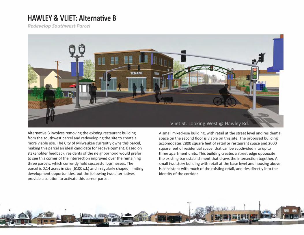
HAWLEY & VLIET: Alterna ve BRedevelop Southwest Parcel
Alterna ve B involves removing the exis ng restaurant building from the southwest parcel and redeveloping the site to create a more viable use. The City of Milwaukee currently owns this parcel, making this parcel an ideal candidate for redevelopment. Based on stakeholder feedback, residents of the neighborhood would prefer to see this corner of the intersec on improved over the remaining three parcels, which currently hold successful businesses. The parcel is 0.14 acres in size (6100 s.f.) and irregularly shaped, limi ng development opportuni es, but the following two alterna ves provide a solu on to ac vate this corner parcel.
Vliet St. Looking West @ Hawley Rd.
A small mixed-use building, with retail at the street level and residen al space on the second fl oor is viable on this site. The proposed building accomodates 2800 square feet of retail or restaurant space and 2600 square feet of residen al space, that can be subdivided into up to three apartment units. This building creates a street edge oppoosite the exis ng bar establishment that draws the intersec on together. A small two story building with retail at the base level and housing above is consistent with much of the exis ng retail, and es directly into the iden ty of the corridor.
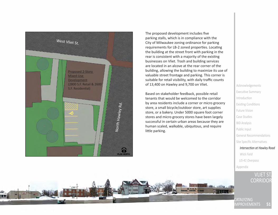
51
VLIET ST.CORRIDOR
CATALYZINGIMPROVEMENTS
Acknowledgements
Execu ve Summary
Introduc on
Exis ng Condi ons
Future Vision
Case Studies
BID Analysis
Public Input
General Recommenda ons
Site Specifi c Alterna ves
Wick Field
US-41 Overpass
Appendix
West Vliet St.
Nor
th H
awle
y Rd
.
Proposed 2-Story Mixed-Use Development(2800 S.F. Retail & 2600 S.F. Residen al)
The proposed development includes fi ve parking stalls, which is in compliance with the City of Milwaukee zoning ordinance for parking requirements for LB-2 zoned proper es. Loca ng the building at the street front with parking in the rear is consistent with a majority of the exis ng businesses on Vliet. Trash and building services are located in an alcove at the rear corner of the building, allowing the building to maximize its use of valuable street frontage and parking. This corner is suitable for retail visibility, with daily traffi c counts of 13,400 on Hawley and 9,700 on Vliet.
Based on stakeholder feedback, possible retail tenants that would be welcomed to the corridor by area residents include a corner or micro grocery store, a small bicycle/outdoor store, art supplies store, or a bakery. Under 5000 square foot corner stores and micro grocery stores have been largely successful in certain urban areas because they are human scaled, walkable, ubiquitous, and require li le parking.
Intersec on at Hawley Road
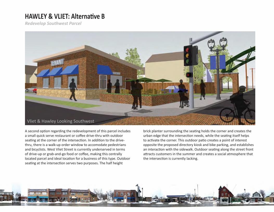
HAWLEY & VLIET: Alterna ve BRedevelop Southwest Parcel
A second op on regarding the redevelopment of this parcel includes a small quick serve restaurant or coff ee drive-thru with outdoor sea ng at the corner of the intersec on. In addi on to the drive-thru, there is a walk-up order window to accomodate pedestrians and bicyclists. West Vliet Street is currently underserved in terms of drive-up or grab-and-go food or coff ee, making this centrally located parcel and ideal loca on for a business of this type. Outdoor sea ng at the intersec on serves two purposes. The half height
brick planter surrounding the sea ng holds the corner and creates the urban edge that the intersec on needs, while the sea ng itself helps to ac vate the corner. This outdoor pa o creates a point of interest opposite the proposed directory kiosk and bike parking, and establishes an interac on with the sidewalk. Outdoor sea ng along the street front a racts customers in the summer and creates a social atmosphere that the intersec on is currently lacking.
Vliet & Hawley Looking Southwest
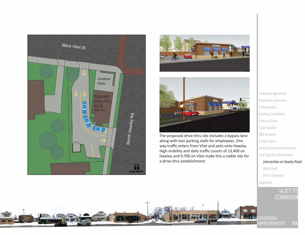
53
VLIET ST.CORRIDOR
CATALYZINGIMPROVEMENTS
Acknowledgements
Execu ve Summary
Introduc on
Exis ng Condi ons
Future Vision
Case Studies
BID Analysis
Public Input
General Recommenda ons
Site Specifi c Alterna ves
Wick Field
US-41 Overpass
Appendix
West Vliet St.
Nor
th H
awle
y Rd
.
Proposed Drive-Thru Q.S.R.960 S.F.
OutdoorPa o
The proposed drive-thru site includes a bypass lane along with two parking stalls for employees. One way traffi c enters from Vliet and exits onto Hawley. High visibility and daily traffi c counts of 13,400 on Hawley and 9,700 on Vliet make this a viable site for a drive-thru establishment. Intersec on at Hawley Road
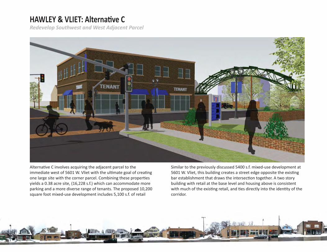
HAWLEY & VLIET: Alterna ve CRedevelop Southwest and West Adjacent Parcel
Alterna ve C involves acquiring the adjacent parcel to the immediate west of 5601 W. Vliet with the ul mate goal of crea ng one large site with the corner parcel. Combining these proper es yields a 0.38 acre site, (16,228 s.f.) which can accommodate more parking and a more diverse range of tenants. The proposed 10,200 square foot mixed-use development includes 5,100 s.f. of retail space and 5,100 s.f. of residen al space.
Similar to the previously discussed 5400 s.f. mixed-use development at 5601 W. Vliet, this building creates a street edge opposite the exis ng bar establishment that draws the intersec on together. A two story building with retail at the base level and housing above is consistent with much of the exis ng retail, and es directly into the iden ty of the corridor.
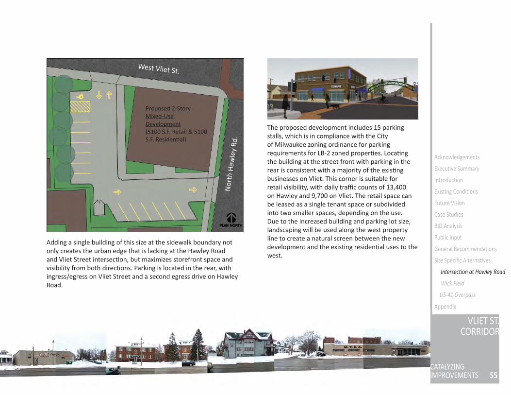
55
VLIET ST.CORRIDOR
CATALYZINGIMPROVEMENTS
Acknowledgements
Execu ve Summary
Introduc on
Exis ng Condi ons
Future Vision
Case Studies
BID Analysis
Public Input
General Recommenda ons
Site Specifi c Alterna ves
Wick Field
US-41 Overpass
Appendix
West Vliet St.
Nor
th H
awle
y Rd
.
Proposed 2-Story Mixed-Use Development(5100 S.F. Retail & 5100 S.F. Residen al)
The proposed development includes 15 parking stalls, which is in compliance with the City of Milwaukee zoning ordinance for parking requirements for LB-2 zoned proper es. Loca ng the building at the street front with parking in the rear is consistent with a majority of the exis ng businesses on Vliet. This corner is suitable for retail visibility, with daily traffi c counts of 13,400 on Hawley and 9,700 on Vliet. The retail space can be leased as a single tenant space or subdivided into two smaller spaces, depending on the use. Due to the increased building and parking lot size, landscaping will be used along the west property line to create a natural screen between the new development and the exis ng residen al uses to the west.
Adding a single building of this size at the sidewalk boundary not only creates the urban edge that is lacking at the Hawley Road and Vliet Street intersec on, but maximizes storefront space and visibility from both direc ons. Parking is located in the rear, with ingress/egress on Vliet Street and a second egress drive on Hawley Road.
Intersec on at Hawley Road
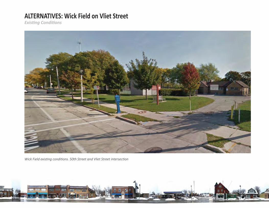
Exis ng Condi onsALTERNATIVES: Wick Field on Vliet Street
Wick Field exis ng condi ons. 50th Street and Vliet Street intersec on
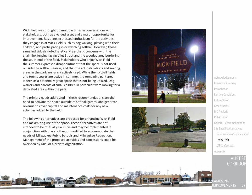
57
VLIET ST.CORRIDOR
CATALYZINGIMPROVEMENTS
Acknowledgements
Execu ve Summary
Introduc on
Exis ng Condi ons
Future Vision
Case Studies
BID Analysis
Public Input
General Recommenda ons
Site Specifi c Alterna ves
Intersec on at Hawley Road
Wick Field
US-41 Overpass
Appendix
Wick Field was brought up mul ple mes in conversa ons with stakeholders, both as a valued asset and a major opportunity for improvement. Residents expressed enthusiasm for the ac vi es they engage in at Wick Field, such as dog walking, playing with their children, and par cipa ng in or watching so ball. However, those same individuals noted safety and aesthe c concerns with the chain link fencing facing Vliet Street and the wooded area bordering the south end of the fi eld. Stakeholders who enjoy Wick Field in the summer expressed disappointment that the space is not used outside the so ball season, and that the art installa ons and sea ng areas in the park are rarely ac vely used. While the so ball fi elds and tennis courts are ac ve in summer, the remaining park area is seen as a poten ally great space that is not being u lized. Dog walkers and parents of small children in par cular were looking for a dedicated area within the park.
The primary needs addressed in these recommenda ons are the need to ac vate the space outside of so ball games, and generate revenue to cover capital and maintenance costs for any new ac vi es added to the fi eld.
The following alterna ves are proposed for enhancing Wick Field and maximizing use of the space. These alterna ves are not intended to be mutually exclusive and may be implemented in conjunc on with one another, or modifi ed to accommodate the needs of Milwaukee Public Schools and Milwaukee Recrea on. Management of the proposed ac vi es and concessions could be overseen by MPS or a private organiza on.
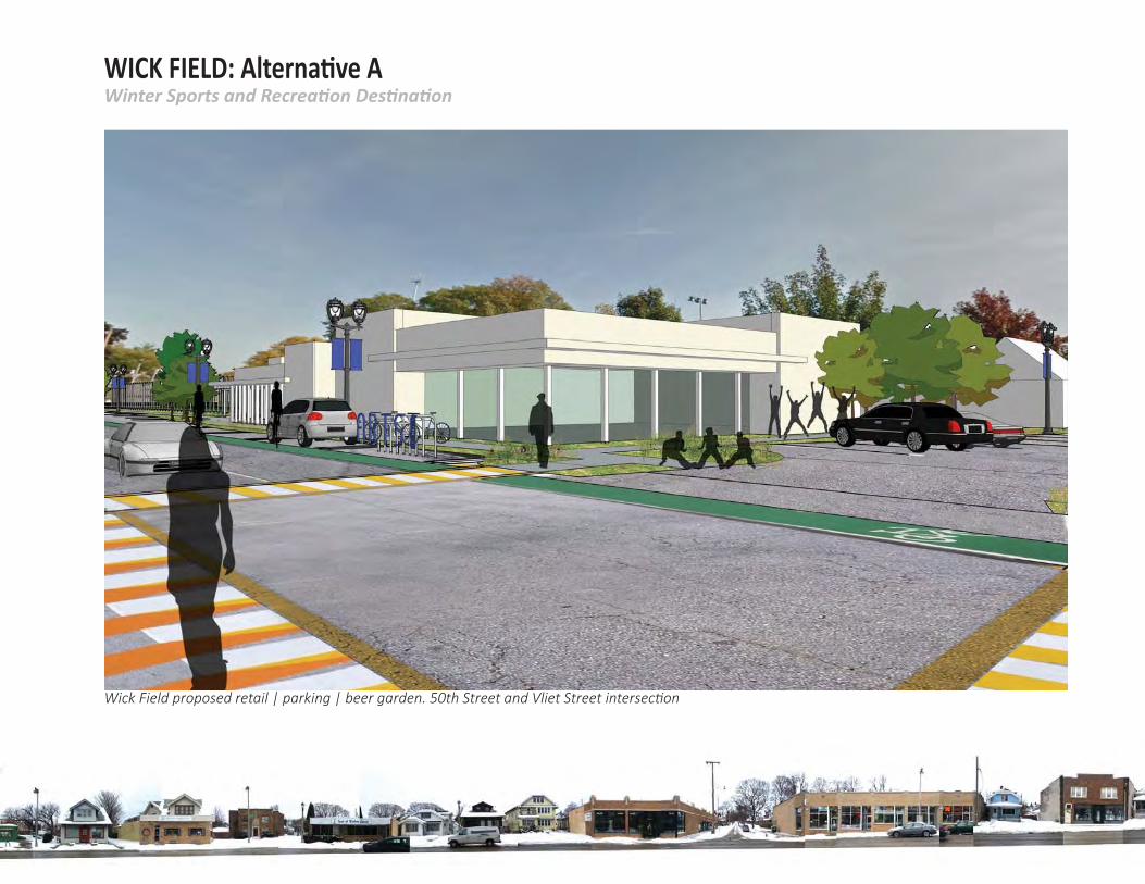
Winter Sports and Recrea on Des na onWICK FIELD: Alterna ve A
Wick Field proposed retail | parking | beer garden. 50th Street and Vliet Street intersec on
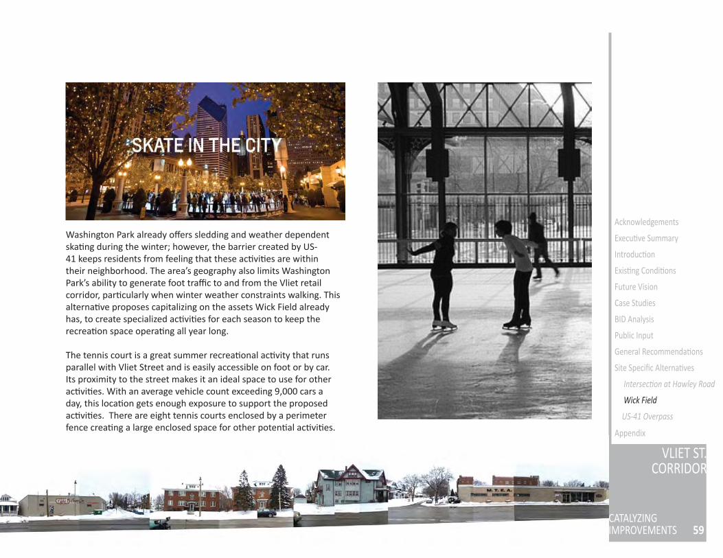
59
VLIET ST.CORRIDOR
CATALYZINGIMPROVEMENTS
Acknowledgements
Execu ve Summary
Introduc on
Exis ng Condi ons
Future Vision
Case Studies
BID Analysis
Public Input
General Recommenda ons
Site Specifi c Alterna ves
Intersec on at Hawley Road
US-41 Overpass
Appendix
Washington Park already off ers sledding and weather dependent ska ng during the winter; however, the barrier created by US-41 keeps residents from feeling that these ac vi es are within their neighborhood. The area’s geography also limits Washington Park’s ability to generate foot traffi c to and from the Vliet retail corridor, par cularly when winter weather constraints walking. This alterna ve proposes capitalizing on the assets Wick Field already has, to create specialized ac vi es for each season to keep the recrea on space opera ng all year long.
The tennis court is a great summer recrea onal ac vity that runs parallel with Vliet Street and is easily accessible on foot or by car. Its proximity to the street makes it an ideal space to use for other ac vi es. With an average vehicle count exceeding 9,000 cars a day, this loca on gets enough exposure to support the proposed ac vi es. There are eight tennis courts enclosed by a perimeter fence crea ng a large enclosed space for other poten al ac vi es.
Wick Field
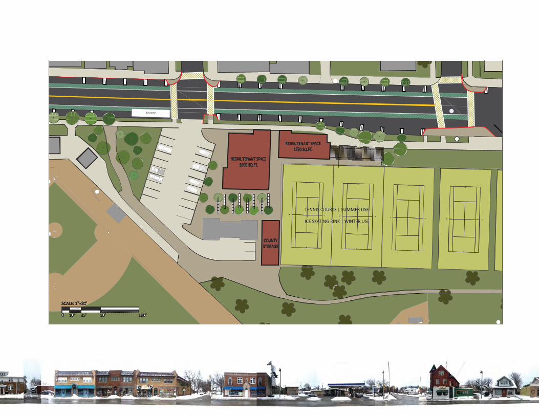
Site Plan: Wick Field future developments at the main entrance
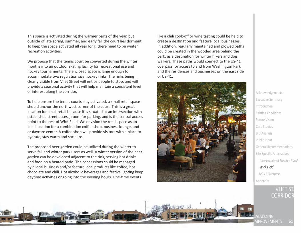
61
VLIET ST.CORRIDOR
CATALYZINGIMPROVEMENTS
Acknowledgements
Execu ve Summary
Introduc on
Exis ng Condi ons
Future Vision
Case Studies
BID Analysis
Public Input
General Recommenda ons
Site Specifi c Alterna ves
Intersec on at Hawley Road
US-41 Overpass
Appendix
This space is ac vated during the warmer parts of the year, but outside of late spring, summer, and early fall the court lies dormant. To keep the space ac vated all year long, there need to be winter recrea on ac vi es.
We propose that the tennis court be converted during the winter months into an outdoor ska ng facility for recrea onal use and hockey tournaments. The enclosed space is large enough to accommodate two regula on size hockey rinks. The rinks being clearly visible from Vliet Street will en ce people to stop, and will provide a seasonal ac vity that will help maintain a consistent level of interest along the corridor.
To help ensure the tennis courts stay ac vated, a small retail space should anchor the northwest corner of the court. This is a great loca on for small retail because it is situated at an intersec on with established street access, room for parking, and is the central access point to the rest of Wick Field. We envision the retail space as an ideal loca on for a combina on coff ee shop, business lounge, and or daycare center. A coff ee shop will provide visitors with a place to hydrate, stay warm and socialize.
The proposed beer garden could be u lized during the winter to serve fall and winter park users as well. A winter version of the beer garden can be developed adjacent to the rink, serving hot drinks and food on a heated pa o. The concessions could be managed by a local business and/or feature local products like coff ee, hot chocolate and chili. Hot alcoholic beverages and fes ve ligh ng keep day me ac vi es ongoing into the evening hours. One- me events
like a chili cook-off or wine tas ng could be held to create a des na on and feature local businesses.In addi on, regularly maintained and plowed paths could be created in the wooded area behind the park, as a des na on for winter hikers and dog walkers. These paths would connect to the US-41 overpass for access to and from Washington Park and the residences and businesses on the east side of US-41.
Beer garden with a bustling social hour
Wick Field
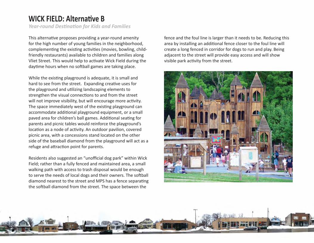
Year-round Des na on for Kids and FamiliesWICK FIELD: Alterna ve B
fence and the foul line is larger than it needs to be. Reducing this area by installing an addi onal fence closer to the foul line will create a long fenced in corridor for dogs to run and play. Being adjacent to the street will provide easy access and will show visible park ac vity from the street.
This alterna ve proposes providing a year-round amenity for the high number of young families in the neighborhood, complemen ng the exis ng ac vi es (movies, bowling, child-friendly restaurants) available to children and families along Vliet Street. This would help to ac vate Wick Field during the day me hours when no so ball games are taking place.
While the exis ng playground is adequate, it is small and hard to see from the street. Expanding crea ve uses for the playground and u lizing landscaping elements to strengthen the visual connec ons to and from the street will not improve visibility, but will encourage more ac vity. The space immediately west of the exis ng playground can accommodate addi onal playground equipment, or a small paved area for children’s ball games. Addi onal sea ng for parents and picnic tables would reinforce the playground’s loca on as a node of ac vity. An outdoor pavilion, covered picnic area, with a concessions stand located on the other side of the baseball diamond from the playground will act as a refuge and a rac on point for parents.
Residents also suggested an “unoffi cial dog park” within Wick Field; rather than a fully fenced and maintained area, a small walking path with access to trash disposal would be enough to serve the needs of local dogs and their owners. The so ball diamond nearest to the street and MPS has a fence separa ng the so ball diamond from the street. The space between the
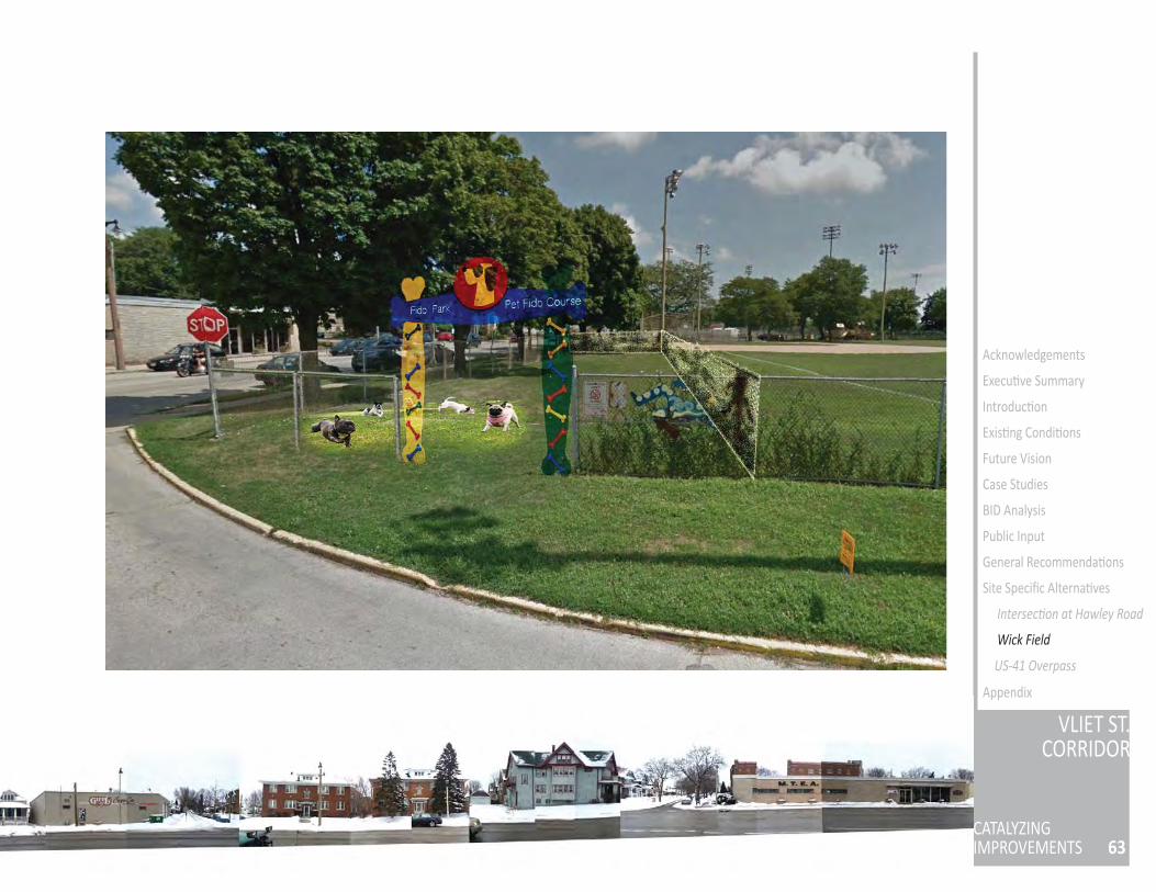
63
VLIET ST.CORRIDOR
CATALYZINGIMPROVEMENTS
Acknowledgements
Execu ve Summary
Introduc on
Exis ng Condi ons
Future Vision
Case Studies
BID Analysis
Public Input
General Recommenda ons
Site Specifi c Alterna ves
Intersec on at Hawley Road
US-41 Overpass
Appendix
Wick Field
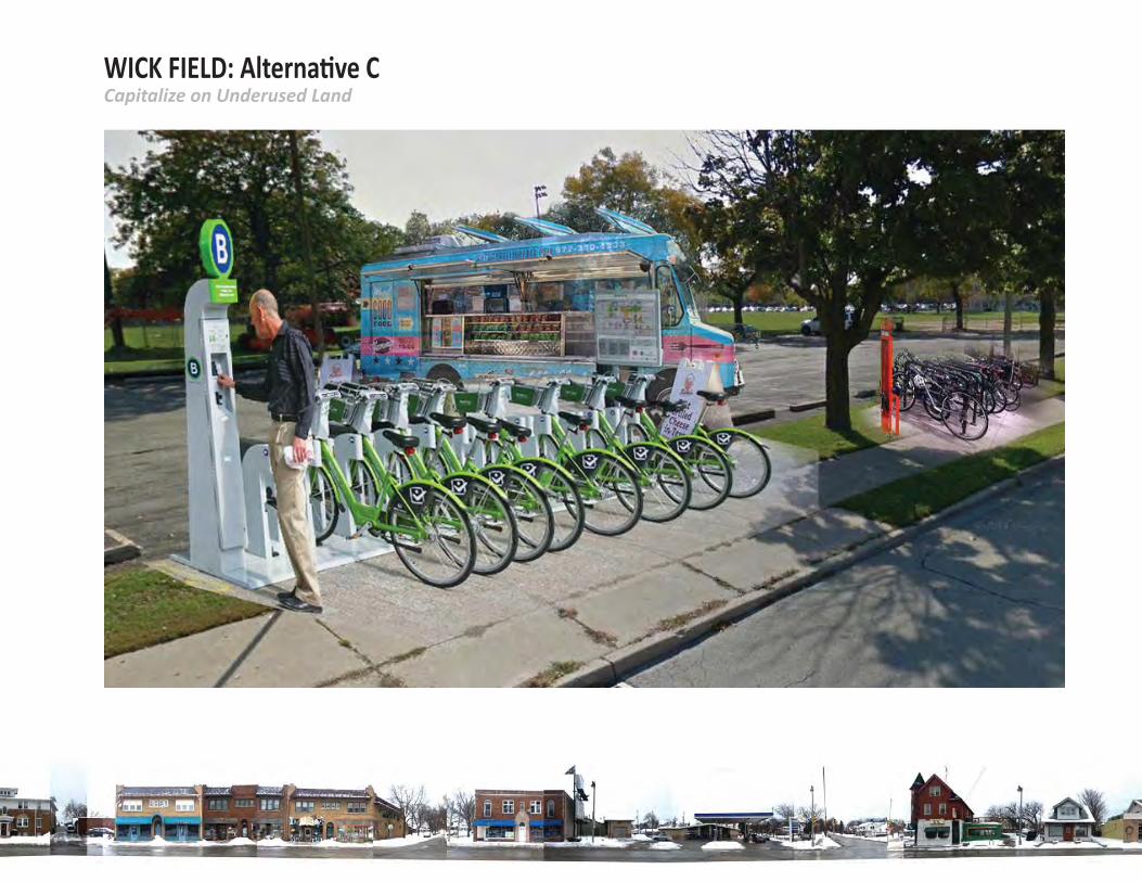
Capitalize on Underused LandWICK FIELD: Alterna ve C
65
VLIET ST.CORRIDOR
CATALYZINGIMPROVEMENTS
Acknowledgements
Execu ve Summary
Introduc on
Exis ng Condi ons
Future Vision
Case Studies
BID Analysis
Public Input
General Recommenda ons
Site Specifi c Alterna ves
Intersec on at Hawley Road
US-41 Overpass
Appendix
Several areas within Wick Field are currently not in ac ve use. Neighbors iden fi ed the parking lot, fencing, and courtyard areas facing Vliet Street as una rac ve and underused. These areas include a rac ve, shade-providing trees and areas clearly designed for sea ng and passive recrea on, but are rarely occupied. In addi on, neighbors noted the parking areas behind MPS and facing Vliet Street as poten ally valuable space during so ball games or other events.
The area at 50th Street directly facing Vliet Street, currently occupied by sculpture pieces and walkways, is an ideal loca on for a small cafe or beer garden style concession venture. This could be managed by a local restaurant, or carry their products. The shaded areas behind the tennis courts and parking lot could benefi t from addi onal sea ng, including picnic tables, for park and concessions visitors.
The exis ng metal sculpture and sea ng facing Vliet Street could be developed into eye-catching landmarks that refl ect the chosen design aesthe c. Rota ng art installa ons, event calendar signage, and seasonal landscaping would keep visitors’ interest year round.
The MPS parking lot, currently in use during the MPS workday, can be u lized during Wick Field events held outside of work hours to accommodate parking for so ball tournaments and various local events.
The lot facing Vliet Street can then be repurposed for temporary uses like food truck parking, event tents, or a farm stand. The grass
parkway paralleling Vliet Street and parking lot can become the primary loca on for public bicycle repair and parking, and include other ameni es as described in the bicycle/pedestrian improvements recommenda ons.
Finally, the wooded area behind the park is currently unused and considered una rac ve and perceived to be dangerous by neighbors. This alterna ve suggests providing addi onal access to this area by crea ng well-maintained, lit paths that connect Mar n Drive to the Vliet Street intersec on with US-41. This will not only ac vate the wooded area and provide another venue for park recrea on (par cularly for dog walkers from surrounding residen al streets), but also create a more direct pedestrian connec on to the Vliet retail corridor through the park. To maintain a rela onship in response to the north / south street grid, signage and or art installa ons will be located at points where the future path and north / south streets will theore cally intersect. The person traveling on the pathway will be able to orient themselves to the street grid, and the brightly colored installa ons will create a visible beacon from Vliet Street.
Wick Field
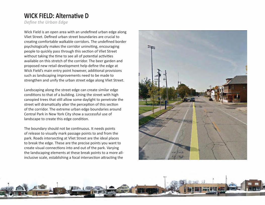
Defi ne the Urban EdgeWICK FIELD: Alterna ve D
Wick Field is an open area with an undefi ned urban edge along Vliet Street. Defi ned urban street boundaries are crucial to crea ng comfortable walkable corridors. The undefi ned border psychologically makes the corridor uninvi ng, encouraging people to quickly pass through this sec on of Vliet Street without taking the me to see all of poten al ac vi es available on this stretch of the corridor. The beer garden and proposed new retail development help defi ne the edge at Wick Field’s main entry point however, addi onal provisions such as landscaping improvements need to be made to strengthen and unify the urban street edge along Vliet Street.
Landscaping along the street edge can create similar edge condi ons to that of a building. Lining the street with high canopied trees that s ll allow some daylight to penetrate the street will drama cally alter the percep on of this sec on of the corridor. The extreme urban edge boundaries around Central Park in New York City show a successful use of landscape to create this edge condi on.
The boundary should not be con nuous. It needs points of release to visually mark passage points to and from the park. Roads intersec ng at Vliet Street are the ideal places to break the edge. These are the precise points you want to create visual connec ons into and out of the park. Varying the landscaping elements at these break points to a more all-inclusive scale, establishing a focal intersec on a rac ng the
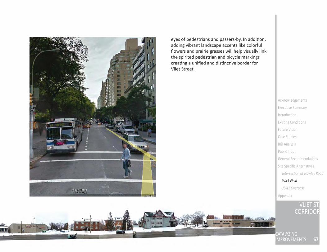
67
VLIET ST.CORRIDOR
CATALYZINGIMPROVEMENTS
Acknowledgements
Execu ve Summary
Introduc on
Exis ng Condi ons
Future Vision
Case Studies
BID Analysis
Public Input
General Recommenda ons
Site Specifi c Alterna ves
Intersec on at Hawley Road
US-41 Overpass
Appendix
eyes of pedestrians and passers-by. In addi on, adding vibrant landscape accents like colorful fl owers and prairie grasses will help visually link the spirited pedestrian and bicycle markings crea ng a unifi ed and dis nc ve border for Vliet Street.
Wick Field
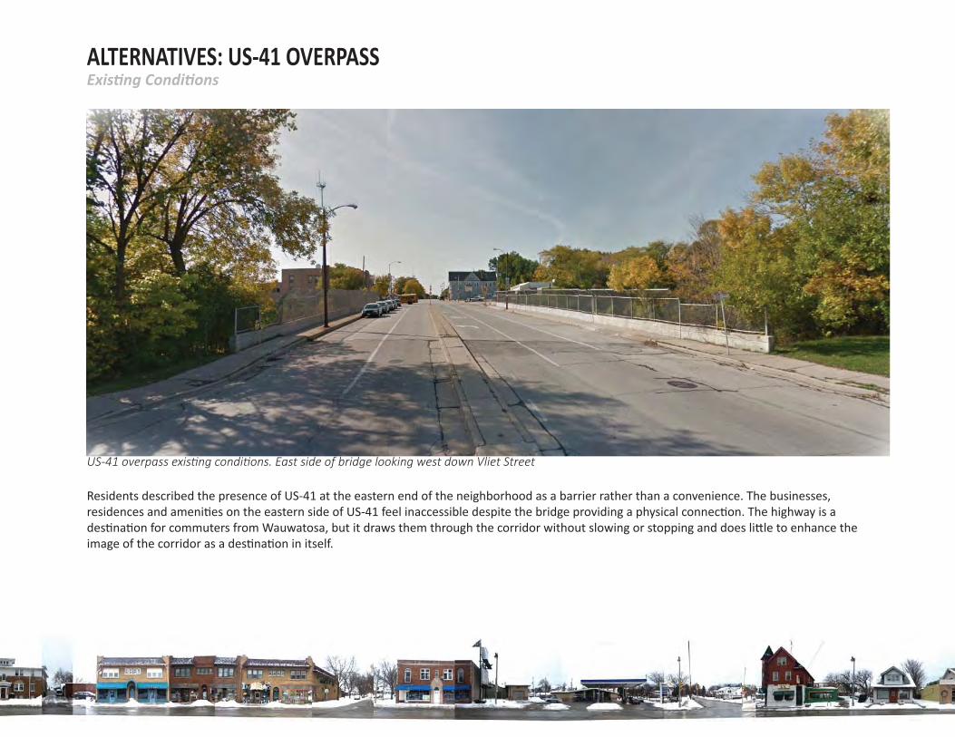
ALTERNATIVES: US-41 OVERPASS
US-41 overpass exis ng condi ons. East side of bridge looking west down Vliet Street
Residents described the presence of US-41 at the eastern end of the neighborhood as a barrier rather than a convenience. The businesses, residences and ameni es on the eastern side of US-41 feel inaccessible despite the bridge providing a physical connec on. The highway is a des na on for commuters from Wauwatosa, but it draws them through the corridor without slowing or stopping and does li le to enhance the image of the corridor as a des na on in itself.
Exis ng Condi ons
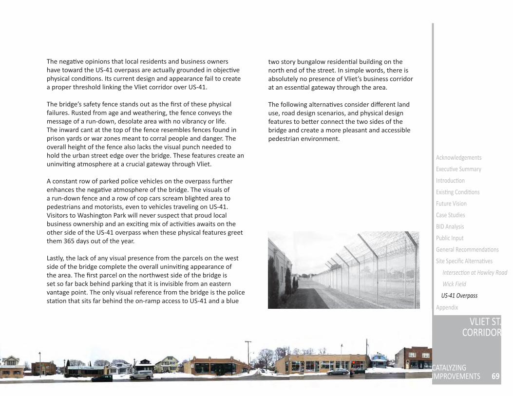
69
VLIET ST.CORRIDOR
CATALYZINGIMPROVEMENTS
Acknowledgements
Execu ve Summary
Introduc on
Exis ng Condi ons
Future Vision
Case Studies
BID Analysis
Public Input
General Recommenda ons
Site Specifi c Alterna ves
Intersec on at Hawley Road
Wick Field
US-41 Overpass
Appendix
two story bungalow residen al building on the north end of the street. In simple words, there is absolutely no presence of Vliet’s business corridor at an essen al gateway through the area.
The following alterna ves consider diff erent land use, road design scenarios, and physical design features to be er connect the two sides of the bridge and create a more pleasant and accessible pedestrian environment.
The nega ve opinions that local residents and business owners have toward the US-41 overpass are actually grounded in objec ve physical condi ons. Its current design and appearance fail to create a proper threshold linking the Vliet corridor over US-41.
The bridge’s safety fence stands out as the fi rst of these physical failures. Rusted from age and weathering, the fence conveys the message of a run-down, desolate area with no vibrancy or life. The inward cant at the top of the fence resembles fences found in prison yards or war zones meant to corral people and danger. The overall height of the fence also lacks the visual punch needed to hold the urban street edge over the bridge. These features create an uninvi ng atmosphere at a crucial gateway through Vliet.
A constant row of parked police vehicles on the overpass further enhances the nega ve atmosphere of the bridge. The visuals of a run-down fence and a row of cop cars scream blighted area to pedestrians and motorists, even to vehicles traveling on US-41. Visitors to Washington Park will never suspect that proud local business ownership and an exci ng mix of ac vi es awaits on the other side of the US-41 overpass when these physical features greet them 365 days out of the year.
Lastly, the lack of any visual presence from the parcels on the west side of the bridge complete the overall uninvi ng appearance of the area. The fi rst parcel on the northwest side of the bridge is set so far back behind parking that it is invisible from an eastern vantage point. The only visual reference from the bridge is the police sta on that sits far behind the on-ramp access to US-41 and a blue
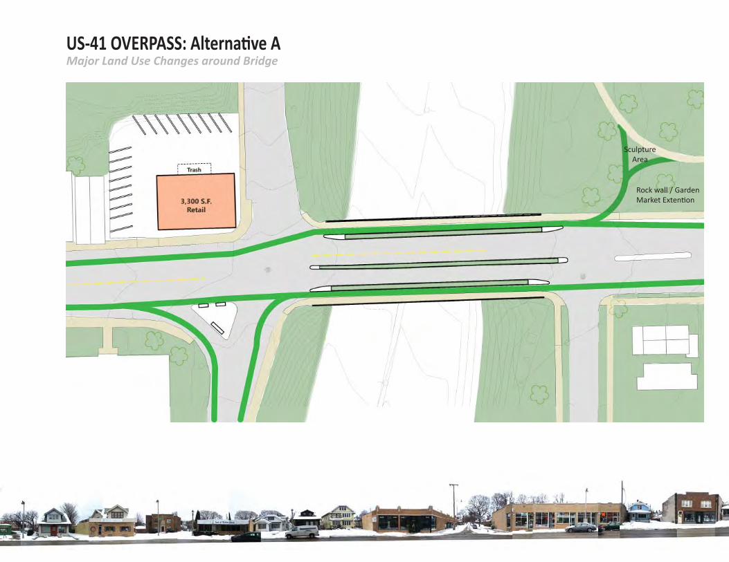
US-41 OVERPASS: Alterna ve AMajor Land Use Changes around Bridge
Sculpture Area
Rock wall / Garden Market Exten on
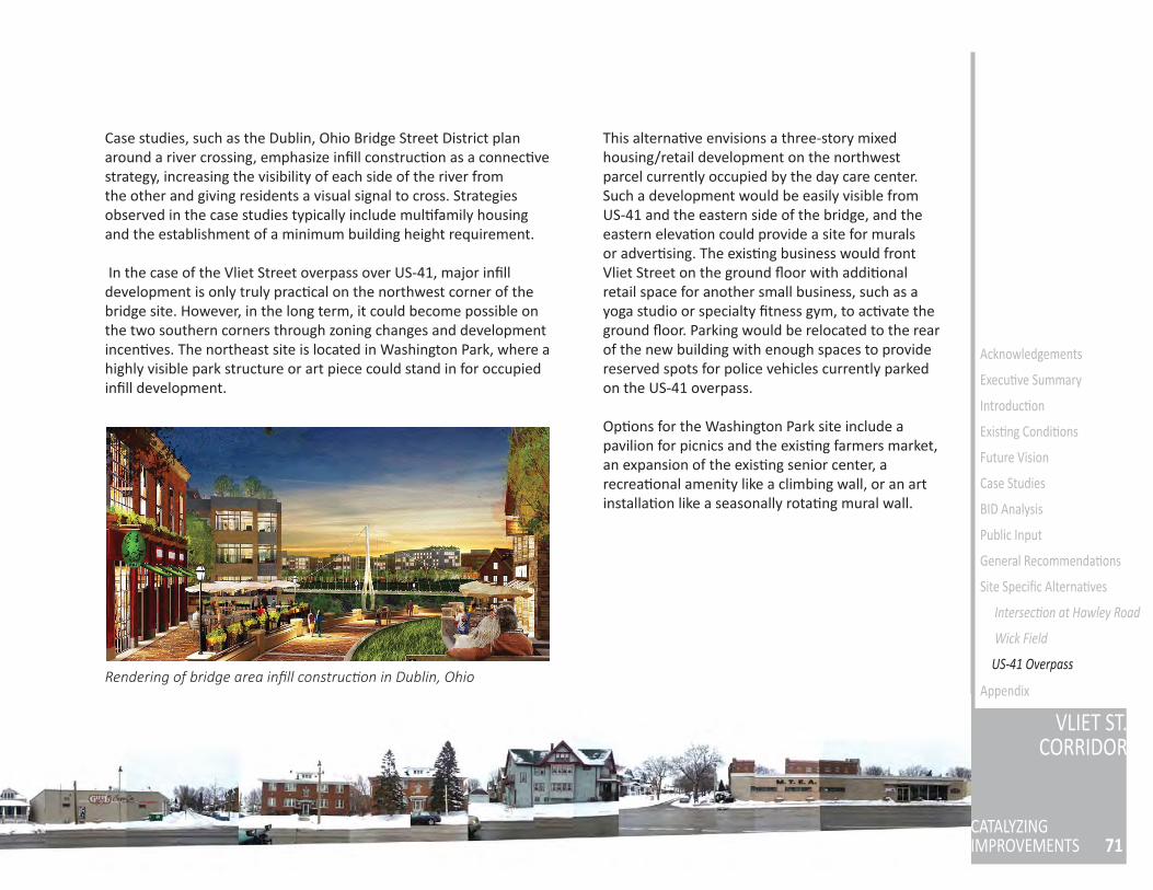
71
VLIET ST.CORRIDOR
CATALYZINGIMPROVEMENTS
Acknowledgements
Execu ve Summary
Introduc on
Exis ng Condi ons
Future Vision
Case Studies
BID Analysis
Public Input
General Recommenda ons
Site Specifi c Alterna ves
Intersec on at Hawley Road
Wick Field
Appendix
Case studies, such as the Dublin, Ohio Bridge Street District plan around a river crossing, emphasize infi ll construc on as a connec ve strategy, increasing the visibility of each side of the river from the other and giving residents a visual signal to cross. Strategies observed in the case studies typically include mul family housing and the establishment of a minimum building height requirement.
In the case of the Vliet Street overpass over US-41, major infi ll development is only truly prac cal on the northwest corner of the bridge site. However, in the long term, it could become possible on the two southern corners through zoning changes and development incen ves. The northeast site is located in Washington Park, where a highly visible park structure or art piece could stand in for occupied infi ll development.
Rendering of bridge area infi ll construc on in Dublin, Ohio
This alterna ve envisions a three-story mixed housing/retail development on the northwest parcel currently occupied by the day care center. Such a development would be easily visible from US-41 and the eastern side of the bridge, and the eastern eleva on could provide a site for murals or adver sing. The exis ng business would front Vliet Street on the ground fl oor with addi onal retail space for another small business, such as a yoga studio or specialty fi tness gym, to ac vate the ground fl oor. Parking would be relocated to the rear of the new building with enough spaces to provide reserved spots for police vehicles currently parked on the US-41 overpass.
Op ons for the Washington Park site include a pavilion for picnics and the exis ng farmers market, an expansion of the exis ng senior center, a recrea onal amenity like a climbing wall, or an art installa on like a seasonally rota ng mural wall.
US-41 Overpass
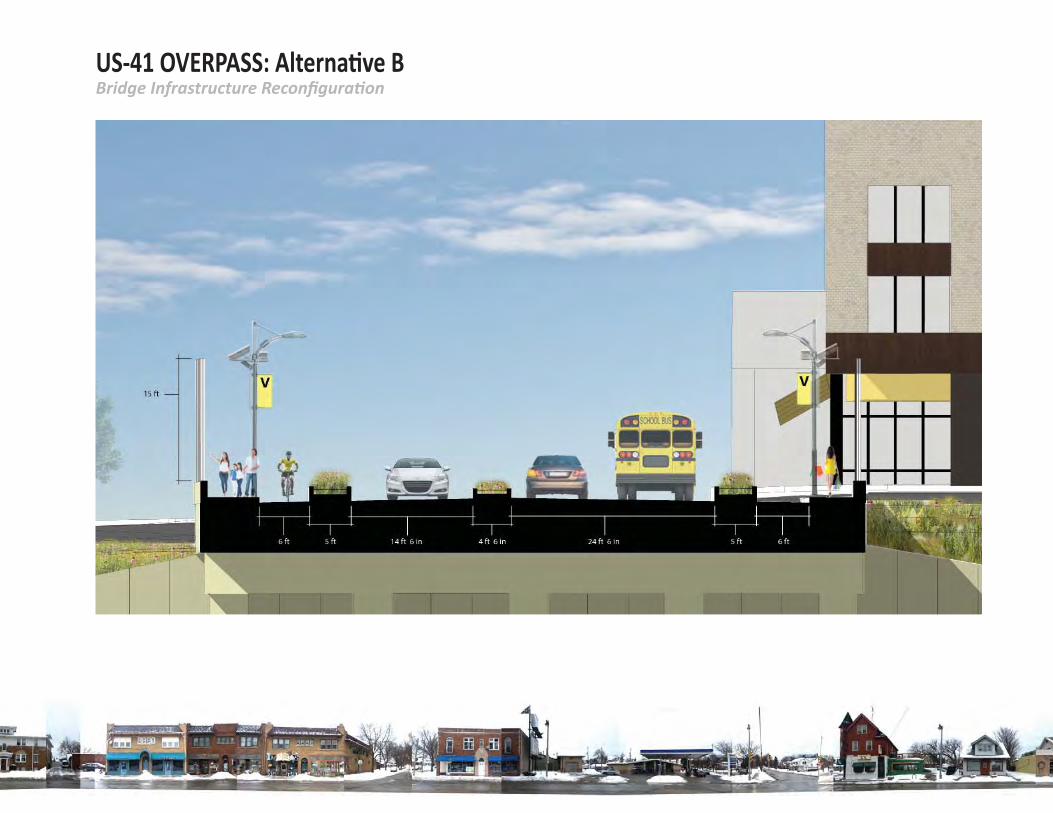
US-41 OVERPASS: Alterna ve BBridge Infrastructure Reconfi gura on
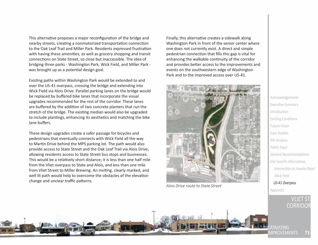
73
VLIET ST.CORRIDOR
CATALYZINGIMPROVEMENTS
Acknowledgements
Execu ve Summary
Introduc on
Exis ng Condi ons
Future Vision
Case Studies
BID Analysis
Public Input
General Recommenda ons
Site Specifi c Alterna ves
Intersec on at Hawley Road
Wick Field
Appendix
This alterna ve proposes a major reconfi gura on of the bridge and nearby streets, crea ng a nonmotorized transporta on connec on to the Oak Leaf Trail and Miller Park. Residents expressed frustra on with having these ameni es, as well as grocery shopping and transit connec ons on State Street, so close but inaccessible. The idea of bridging three parks - Washington Park, Wick Field, and Miller Park - was brought up as a poten al design goal.
Exis ng paths within Washington Park would be extended to and over the US-41 overpass, crossing the bridge and extending into Wick Field via Alois Drive. Parallel parking lanes on the bridge would be replaced by buff ered bike lanes that incorporate the visual upgrades recommended for the rest of the corridor. These lanes are buff ered by the addi on of two concrete planters that run the stretch of the bridge. The exis ng median would also be upgraded to include plan ngs, enhancing its aesthe cs and matching the bike lane buff ers.
These design upgrades create a safer passage for bicycles and pedestrians that eventually connects with Wick Field all the way to Mar n Drive behind the MPS parking lot. The path would also provide access to State Street and the Oak Leaf Trail via Alois Drive, allowing residents access to State Street bus stops and businesses. This would be a rela vely short distance; it is less than one half mile from the Vliet overpass to State and Alois, and less than one mile from Vliet Street to Miller Brewing. An invi ng, clearly marked, and well lit path would help to overcome the obstacles of the eleva on change and unclear traffi c pa erns.
Finally, this alterna ve creates a sidewalk along Washington Park in front of the senior center where one does not currently exist. A direct and simple pedestrian connec on that fi lls this gap is vital for enhancing the walkable con nuity of the corridor and provides be er access to the improvements and events on the southwestern edge of Washington Park and to the improved access over US-41.
Alois Drive route to State Street US-41 Overpass
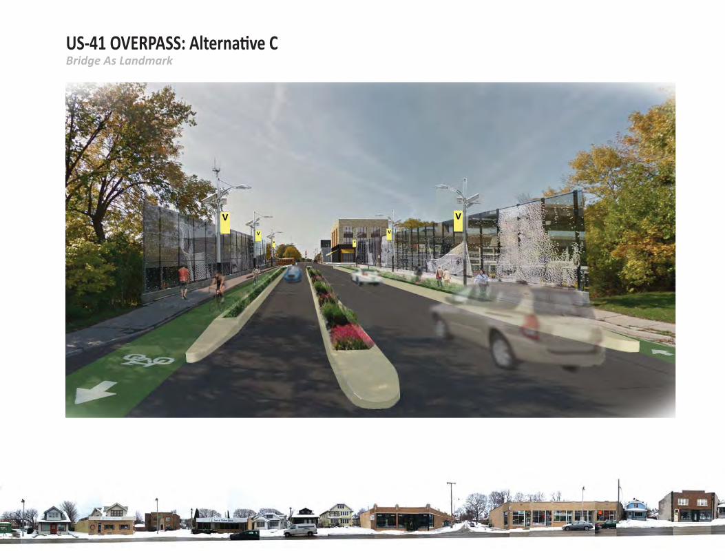
US-41 OVERPASS: Alterna ve CBridge As Landmark
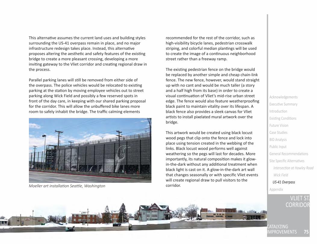
75
VLIET ST.CORRIDOR
CATALYZINGIMPROVEMENTS
Acknowledgements
Execu ve Summary
Introduc on
Exis ng Condi ons
Future Vision
Case Studies
BID Analysis
Public Input
General Recommenda ons
Site Specifi c Alterna ves
Intersec on at Hawley Road
Wick Field
AppendixMoeller art installa on Sea le, Washington
This alterna ve assumes the current land uses and building styles surrounding the US-41 overpass remain in place, and no major infrastructure redesign takes place. Instead, this alterna ve proposes altering the aesthe c and safety features of the exis ng bridge to create a more pleasant crossing, developing a more invi ng gateway to the Vliet corridor and crea ng regional draw in the process.
Parallel parking lanes will s ll be removed from either side of the overpass. The police vehicles would be relocated to exis ng parking at the sta on by moving employee vehicles out to street parking along Wick Field and possibly a few reserved spots in front of the day care, in keeping with our shared parking proposal for the corridor. This will allow the unbuff ered bike lanes more room to safely inhabit the bridge. The traffi c calming elements
recommended for the rest of the corridor, such as high-visibility bicycle lanes, pedestrian crosswalk striping, and colorful median plan ngs will be used to create the image of a con nuous neighborhood street rather than a freeway ramp.
The exis ng pedestrian fence on the bridge would be replaced by another simple and cheap chain-link fence. The new fence, however, would stand straight up with no cant and would be much taller (a story and a half high from its base) in order to create a visual con nua on of Vliet’s mid-rise urban street edge. The fence would also feature weatherproofi ng black paint to maintain vitality over its lifespan. A black fence also provides a sleek canvas for Vliet ar sts to install pixelated mural artwork over the bridge.
This artwork would be created using black locust wood pegs that clip onto the fence and lock into place using tension created in the webbing of the links. Black locust wood performs well against weathering so the pegs will last for decades. More importantly, its natural composi on makes it glow-in-the-dark without any addi onal treatment when black light is cast on it. A glow-in-the-dark art wall that changes seasonally or with specifi c Vliet events will create regional draw to pull visitors to the corridor.
US-41 Overpass
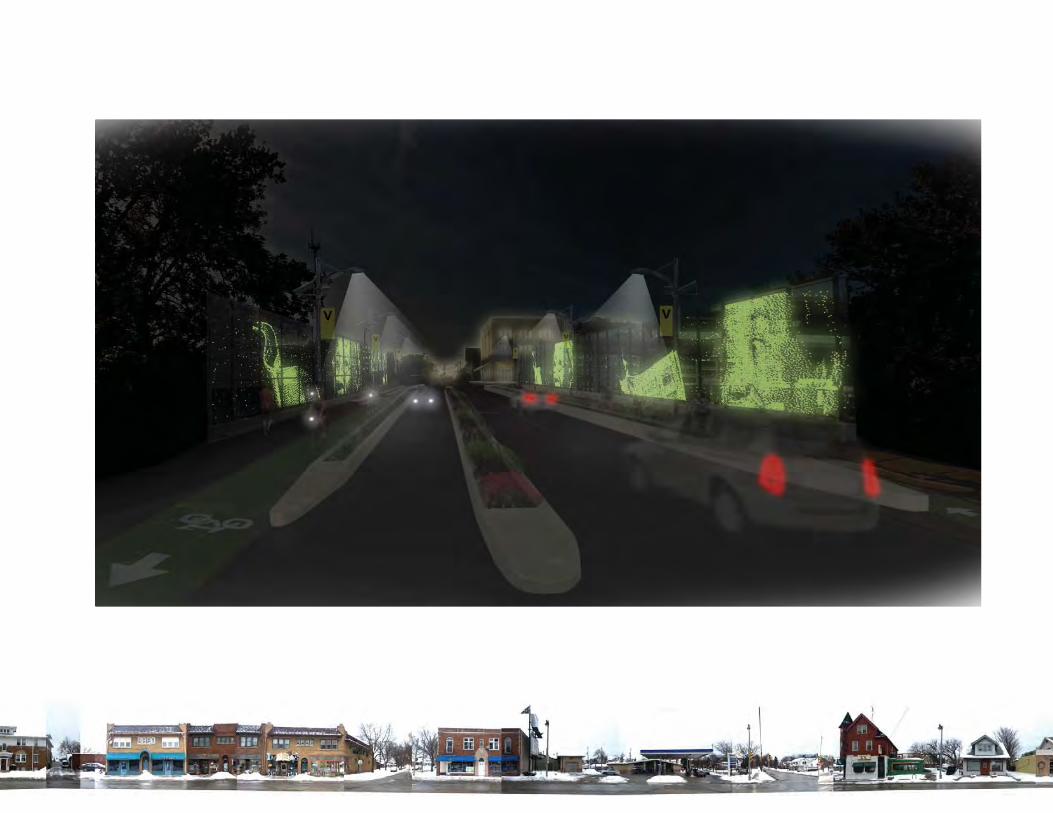
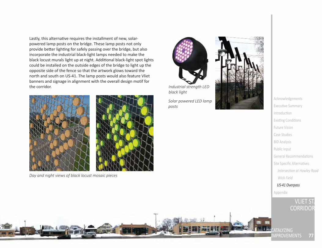
77
VLIET ST.CORRIDOR
CATALYZINGIMPROVEMENTS
Acknowledgements
Execu ve Summary
Introduc on
Exis ng Condi ons
Future Vision
Case Studies
BID Analysis
Public Input
General Recommenda ons
Site Specifi c Alterna ves
Intersec on at Hawley Road
Wick Field
Appendix
Industrial strength LED black light
Lastly, this alterna ve requires the installment of new, solar-powered lamp posts on the bridge. These lamp posts not only provide be er ligh ng for safely passing over the bridge, but also incorporate the industrial black-light lamps needed to make the black locust murals light up at night. Addi onal black-light spot lights could be installed on the outside edges of the bridge to light up the opposite side of the fence so that the artwork glows toward the north and south on US-41. The lamp posts would also feature Vliet banners and signage in alignment with the overall design mo f for the corridor.
Solar powered LED lamp posts
Day and night views of black locust mosaic pieces
US-41 Overpass
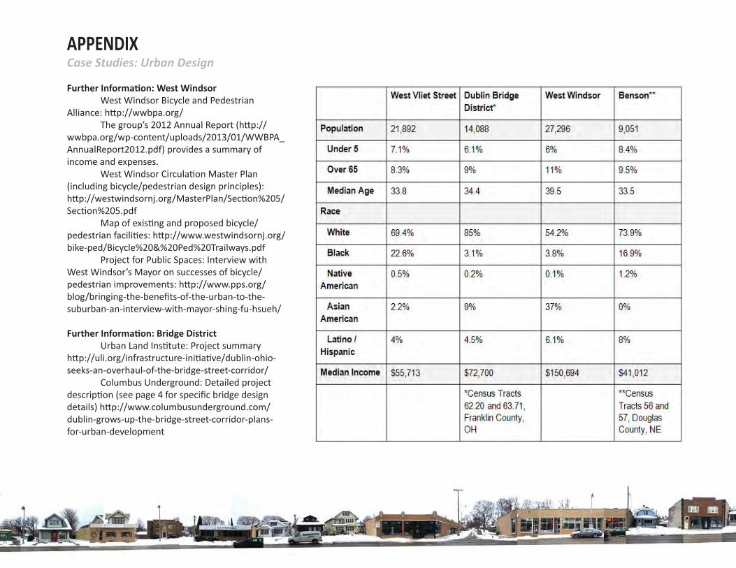
APPENDIXCase Studies: Urban Design
Further Informa on: West Windsor West Windsor Bicycle and Pedestrian Alliance: h p://wwbpa.org/ The group’s 2012 Annual Report (h p://wwbpa.org/wp-content/uploads/2013/01/WWBPA_AnnualReport2012.pdf) provides a summary of income and expenses. West Windsor Circula on Master Plan (including bicycle/pedestrian design principles): h p://westwindsornj.org/MasterPlan/Sec on%205/Sec on%205.pdf Map of exis ng and proposed bicycle/pedestrian facili es: h p://www.westwindsornj.org/bike-ped/Bicycle%20&%20Ped%20Trailways.pdf Project for Public Spaces: Interview with West Windsor’s Mayor on successes of bicycle/pedestrian improvements: h p://www.pps.org/blog/bringing-the-benefi ts-of-the-urban-to-the-suburban-an-interview-with-mayor-shing-fu-hsueh/
Further Informa on: Bridge District Urban Land Ins tute: Project summary h p://uli.org/infrastructure-ini a ve/dublin-ohio-seeks-an-overhaul-of-the-bridge-street-corridor/ Columbus Underground: Detailed project descrip on (see page 4 for specifi c bridge design details) h p://www.columbusunderground.com/dublin-grows-up-the-bridge-street-corridor-plans-for-urban-development
79
VLIET ST.CORRIDOR
CATALYZINGIMPROVEMENTS
Acknowledgements
Execu ve Summary
Introduc on
Exis ng Condi ons
Future Vision
Case Studies
BID Analysis
Public Input
General Recommenda ons
Site Specifi c Alterna ves
Intersec on at Hawley Road
Wick Field
US-41 Overpass
Appendix
City of Dublin: Project summary and planning documents h p://dublinohiousa.gov/planning/bridge-street-district/ Full district redevelopment zoning and design code: h p://dublinohiousa.gov/dev/dev/wp-content/uploads/2012/06/BSC-Development-Code-Approved.pdf Project planning and market analysis: h p://dublinohiousa.gov/dev/dev/wp-content/uploads/2012/06/PlanningFounda ons.pdf
Further Informa on: Benson The majority of informa on for this case study was obtained from Omaha By Design and is available here: h p://www.omahabydesign.org/projects/urban-design-element/civic-omaha/the-maple-street-corridor-project/ BID budgets and annual reports are available here: h p://www.omahabydesign.org/projects/urban-design-element/neighborhood-omaha/benson-ames-alliance/benson-business-improvement-district/ Details about the rain garden design and construc on can be found here: h p://www.omahastormwater.org/ourprojects/58th-street-benson/ News coverage of the project can be found here: h p://www.omaha.com/ar cle/20131028/NEWS/131028725h p://leoadambiga.wordpress.com/2012/08/28/revival-of-benson-business-district-gives-omaha-a-new-des na on-place/h p://www.bensonnebraska.com/2013/11/19/city-of-omaha-to-host-ribbon-cu ng-for-fi rst-bike-corral/
APPENDIXCase Studies: Urban Design
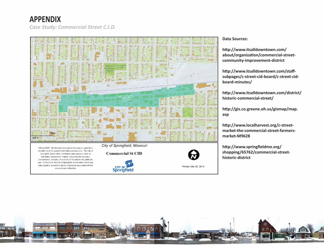
APPENDIXCase Study: Commercial Street C.I.D.
Data Sources:
h p://www.itsalldowntown.com/about/organiza on/commercial-street-community-improvement-district
h p://www.itsalldowntown.com/staff -subpages/c-street-cid-board/c-street-cid-board-minutes/
h p://www.itsalldowntown.com/district/historic-commercial-street/
h p://gis.co.greene.oh.us/gismap/map.asp
h p://www.localharvest.org/c-street-market-the-commercial-street-farmers-market-M9628
h p://www.springfi eldmo.org/shopping/65762/commercial-street-historic-district
81
VLIET ST.CORRIDOR
CATALYZINGIMPROVEMENTS
Acknowledgements
Execu ve Summary
Introduc on
Exis ng Condi ons
Future Vision
Case Studies
BID Analysis
Public Input
General Recommenda ons
Site Specifi c Alterna ves
Intersec on at Hawley Road
Wick Field
US-41 Overpass
Further Informa on: Addi onal Cases The following examples and documents were considered in the recommenda ons provided within this report. While not as relevant to the Vliet Street corridor, they may be valuable references for urban design prac ce:
Goose Hollow Neighborhood, Portland, Oregon: This area, like West Vliet Street, is close to major des na ons within the city but isolated by freeways and topography. These planning documents provide an overview of how the neighborhood intends to improve connec vity: Revisioning Goose Hollow: h p://goosehollow.org/images/ghvision20110317.pdf West Quadrant Goals and Policies: h ps://www.portlandoregon.gov/bps/ar cle/477448 Neighborhood sign and banner program: h p://goosehollow.org/index.php/about/history/goose-hollow-sign-caps
West Sacramento, California: Infi ll housing and other development around a bridge: h p://www.cityofwestsacramento.org/city/depts/comdev/bridgedistrict.asp
Winter City Resources: Recommenda ons for ac va ng Wick Field in winter drew on these examples: Smart Growth and Winter City Design: h p://www.winterci es.com/Resources/ar cles/Smart%20Growth%20and%20winter%20city%20design.pdf Edmonton, Alberta Winter City Strategy (Marke ng,
Events and Design): h p://www.edmonton.ca/city_government/ini a ves_innova on/wintercity-strategy.aspx
Sample pricing for crosswalk/bicycle lane marking:
Bike Lane Paint:Cycle Grip MMAXh p://www.ennisfl int.com/Products/Colored-Bike-Lanes/Cyclegrip
Crosswalk Lane Paint:DuraTherm inlayed asphalt surfacing systemh p://www.ennisfl int.com/Products/Traffi cScapes/DuraTherm
h p://www.ennisfl int.com/getmedia/45a4153b-4990-4e2f-8439-76e14c1677b3/PriceList_Preformed-Thermplas c_PreMark Pricing for markings
h p://www.ennisfl int.com/getmedia/7c66ce86-2743-4ab6-81ad-dadfc1c6891c/PriceList_Preformed-Thermplas c_HotTape Thermoplas c tape pricings
h p://www.ennisfl int.com/getmedia/0733a16e-97c4-445b-83fa-2b85ced043b3/PriceList_Traff cScapes_Traffi cPa erns Traffi c Pa erns pricing list
APPENDIXAddi onal Design Resources
Appendix
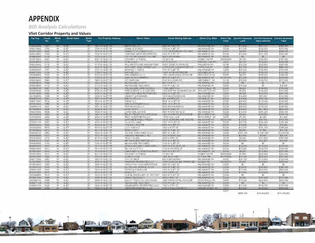
APPENDIXBID Analysis Calcula onsVliet Corridor Property and Values
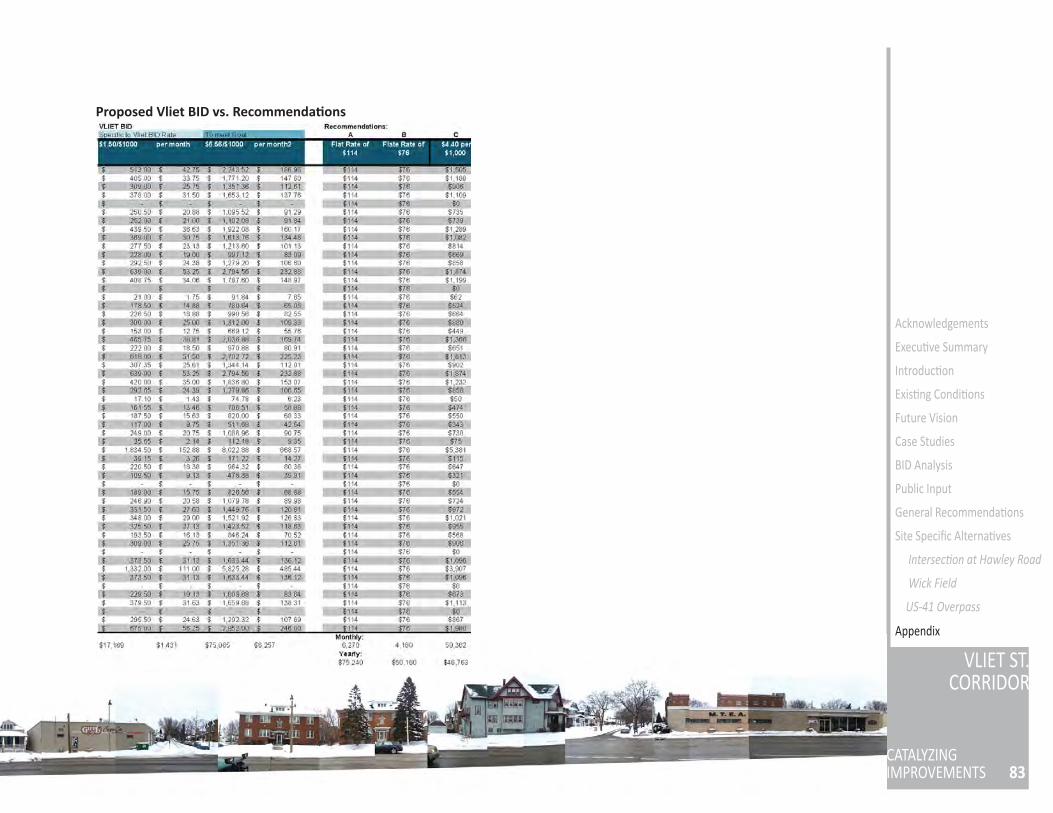
83
VLIET ST.CORRIDOR
CATALYZINGIMPROVEMENTS
Acknowledgements
Execu ve Summary
Introduc on
Exis ng Condi ons
Future Vision
Case Studies
BID Analysis
Public Input
General Recommenda ons
Site Specifi c Alterna ves
Intersec on at Hawley Road
Wick Field
US-41 Overpass
Proposed Vliet BID vs. Recommenda ons
Appendix
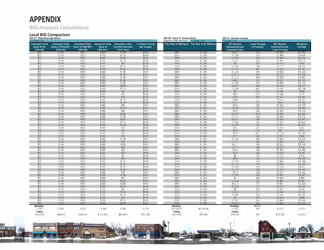
APPENDIXBID Analysis Calcula onsLocal BID Comparison
85
VLIET ST.CORRIDOR
CATALYZINGIMPROVEMENTS
Acknowledgements
Execu ve Summary
Introduc on
Exis ng Condi ons
Future Vision
Case Studies
BID Analysis
Public Input
General Recommenda ons
Site Specifi c Alterna ves
Intersec on at Hawley Road
Wick Field
US-41 Overpass
BID CASE STUDYThe East Side Business Improvement District
Demographic data: h p://www.census.gov/ and h p://fac inder2.census.gov/faces/nav/jsf/pages/index.xhtml
Goals and funding: www.theeastside.org/
The East Side: h p://en.wikipedia.org/wiki/East_Side,_Milwaukee
BID ANALYSIS
BID 27, 38, 41 Opera ng Plan: h ps://milwaukee.legistar.com/Legisla onDetail.aspx?ID=1474623&GUID=2D0D76CA-AA9D-440E-9B81-72722DA49271&Op ons=ID%7CText%7C&Search=BID+28
Cesar E. Chavez Drive website: h p://cesarchavezbid.org/?page_id=16
City of Milwaukee BIDs: h p://city.milwaukee.gov/bids#.U3E48_l7FsM
Downer Avenue website: h p://www.historicdowneravenue.com/
APPENDIXBID Resources
Appendix