vocabulary continental drift plate tectonics subductiontrench volcanohotspot magmalava convection...
TRANSCRIPT
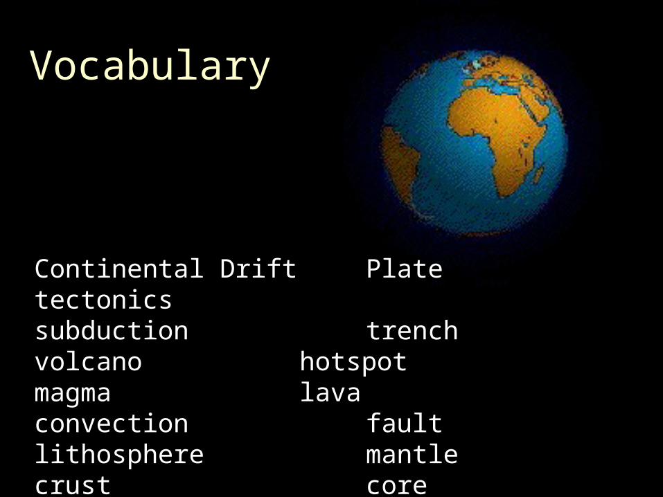
VocabularyVocabulary
Continental DriftContinental Drift Plate tectonicsPlate tectonics subductionsubduction trenchtrenchvolcanovolcano hotspothotspotmagmamagma lavalavaconvectionconvection faultfaultlithospherelithosphere mantlemantlecrust crust core core
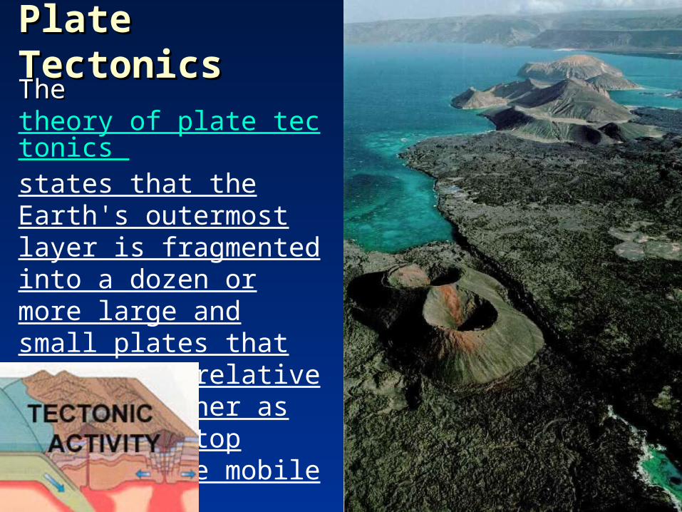
Plate TectonicsPlate TectonicsThe The theory of plate tectonics states that the Earth's outermost layer is fragmented into a dozen or more large and small plates that are moving relative to one another as they ride atop hotter, more mobile material.
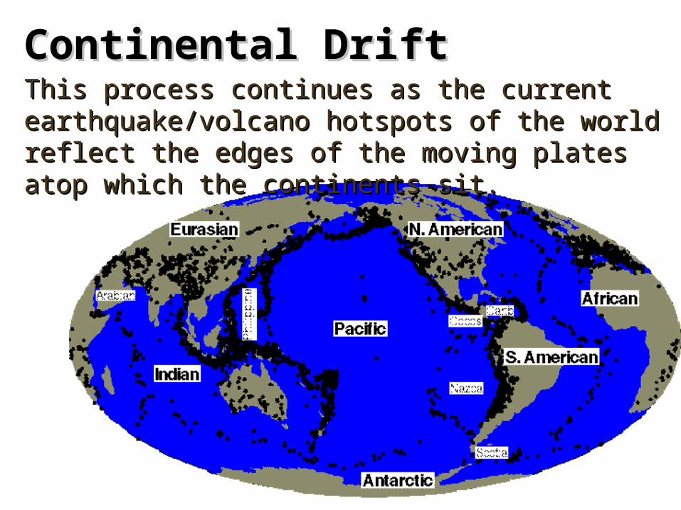
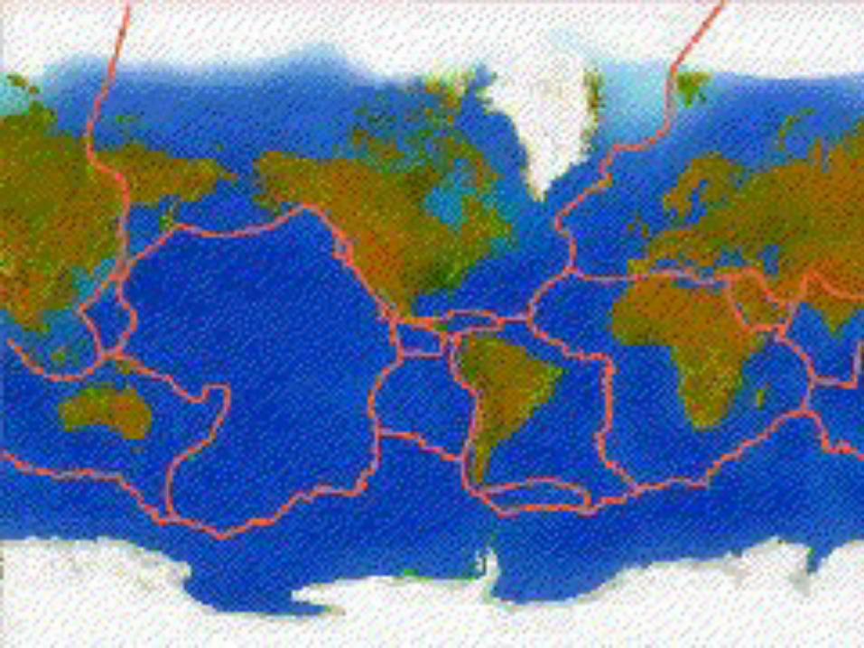
Continental DriftContinental DriftThis process continues as the current This process continues as the current earthquake/volcano hotspots of the world reflect the earthquake/volcano hotspots of the world reflect the edges of the moving plates atop which the continents edges of the moving plates atop which the continents sit.sit.

historical perspective
In geologic In geologic terms, a terms, a plateplate is a large, is a large, rigid slab of rigid slab of solid rock. solid rock. The word The word tectonicstectonics comes from comes from the Greek the Greek root "to root "to build."build."
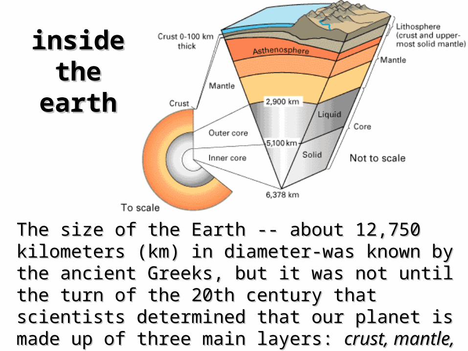
inside inside the earththe earth
The size of the Earth -- about 12,750 kilometers The size of the Earth -- about 12,750 kilometers (km) in diameter-was known by the ancient (km) in diameter-was known by the ancient Greeks, but it was not until the turn of the 20th Greeks, but it was not until the turn of the 20th century that scientists determined that our planet century that scientists determined that our planet is made up of three main layers: is made up of three main layers: crust, mantle,crust, mantle, and and core.core.

The continental crust is composed mostly of The continental crust is composed mostly of granite which allows them to ride on the denser granite which allows them to ride on the denser oceanic plates of volcanic basalt. The crust and oceanic plates of volcanic basalt. The crust and the upper layer of the mantle together make up the upper layer of the mantle together make up a zone of rigid, brittle rock called the a zone of rigid, brittle rock called the Lithosphere.

tectonic platestectonic plates
The lithosphere floats upon the molten mantle.The lithosphere floats upon the molten mantle.
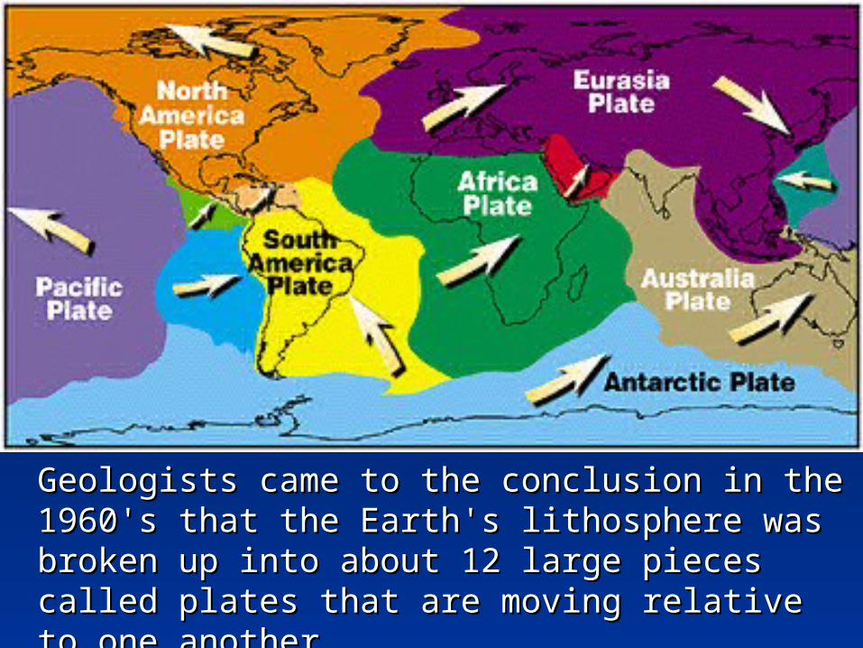
Geologists came to the conclusion in the 1960's Geologists came to the conclusion in the 1960's that the Earth's lithosphere was broken up into that the Earth's lithosphere was broken up into about 12 large pieces called plates that are about 12 large pieces called plates that are moving relative to one another.moving relative to one another.
convectionconvection
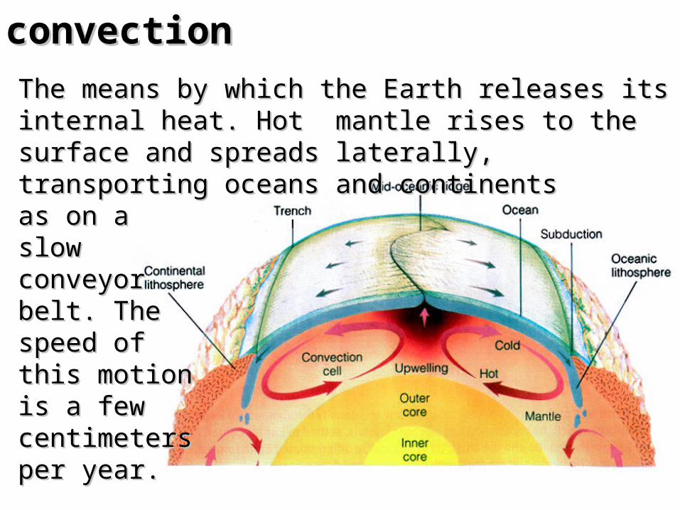
The means by which the Earth releases its The means by which the Earth releases its internal heat. Hot mantle rises to the surface internal heat. Hot mantle rises to the surface and spreads laterally, transporting oceans and and spreads laterally, transporting oceans and continents continents as on a as on a slow slow conveyor conveyor belt. The belt. The speed of speed of this motion this motion is a few is a few centimeters centimeters per year. per year.

convectionconvection
The animation above shows the The animation above shows the result of a computer simulation result of a computer simulation of simple convection. Hot areas of simple convection. Hot areas of the fluid are in reds and of the fluid are in reds and seem to rise, colder in blues seem to rise, colder in blues seem to sink.seem to sink.
It takes place It takes place primarily primarily because because buoyancy forces buoyancy forces are able to are able to overcome viscous overcome viscous resistance.resistance.
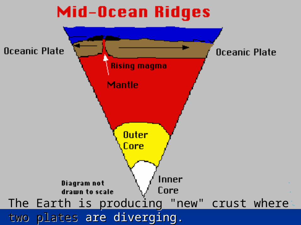
The Earth is producing "new" crust where two The Earth is producing "new" crust where two platesplates areare diverging.diverging.
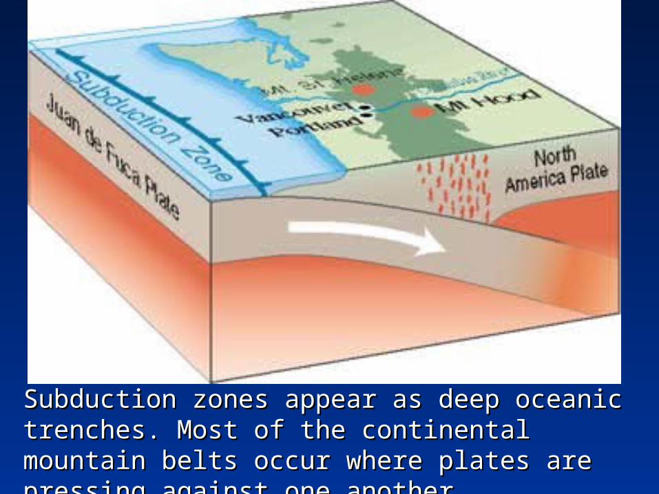
Subduction zones appear as deep oceanic Subduction zones appear as deep oceanic trenches. Most of the continental mountain belts trenches. Most of the continental mountain belts occur where plates are pressing against one occur where plates are pressing against one another. another.
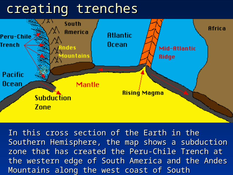
creating trenchescreating trenches
In this cross section of the Earth in the Southern In this cross section of the Earth in the Southern Hemisphere, the map shows a subduction zone that has Hemisphere, the map shows a subduction zone that has created the Peru-Chile Trench at the western edge of created the Peru-Chile Trench at the western edge of South America and the Andes Mountains along the west South America and the Andes Mountains along the west coast of South America. coast of South America.

Plate Plate boundariesboundaries
The red lines on this map of the world indicate The red lines on this map of the world indicate convergent boundaries where two plates collide to form where two plates collide to form mountains or a subduction zone. The yellow lines mountains or a subduction zone. The yellow lines indicate indicate divergent boundaries wheredivergent boundaries where two plates are two plates are moving in opposite directions.moving in opposite directions.
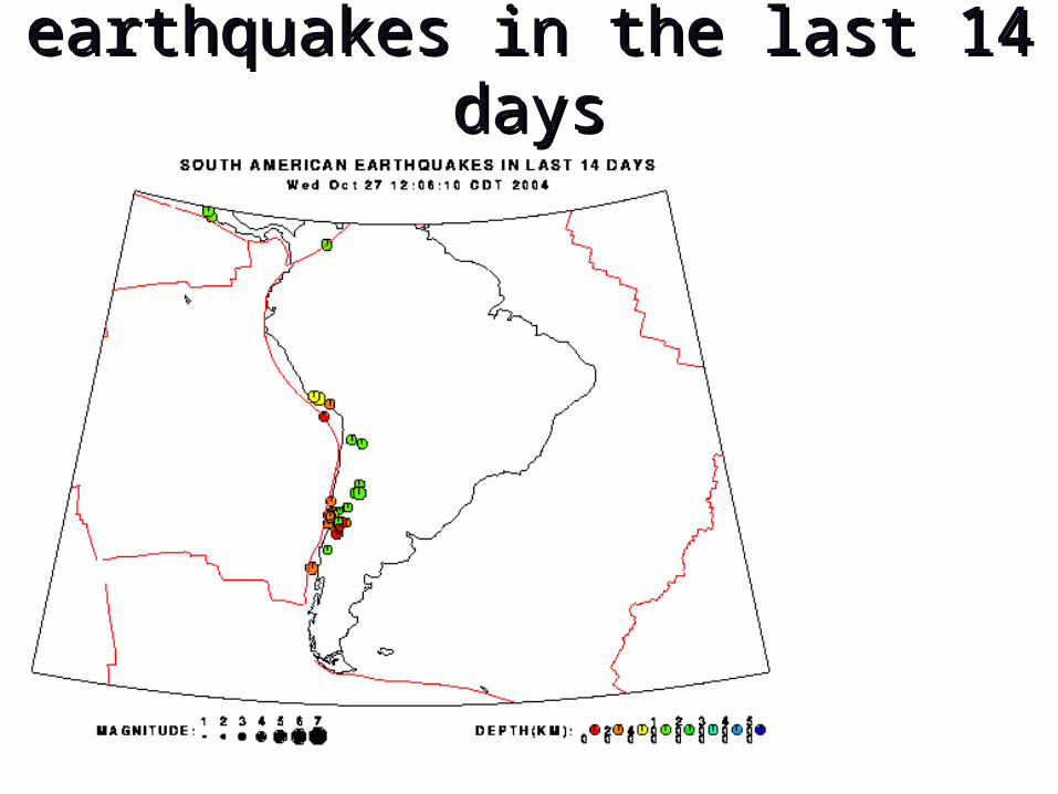
earthquakes in the last 14 daysearthquakes in the last 14 days

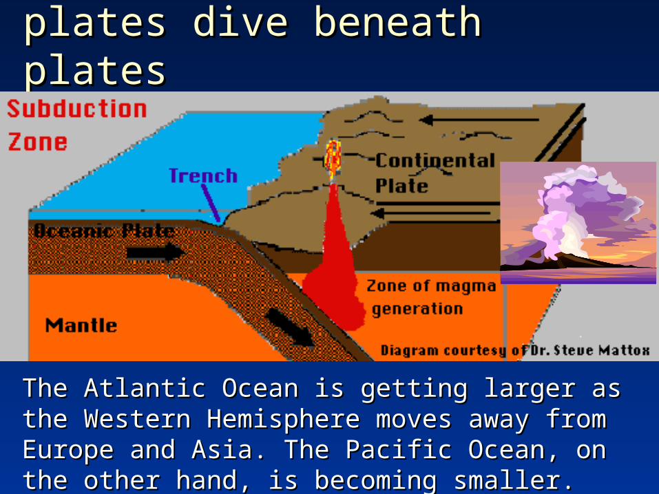
The Atlantic Ocean is getting larger The Atlantic Ocean is getting larger as the Western Hemisphere moves as the Western Hemisphere moves away from Europe and Asia while away from Europe and Asia while the Pacific Ocean is becoming the Pacific Ocean is becoming smaller. This is occurring because smaller. This is occurring because the North American and South the North American and South American plates are moving American plates are moving westward.westward.
Mid-Atlantic RidgeMid-Atlantic Ridge
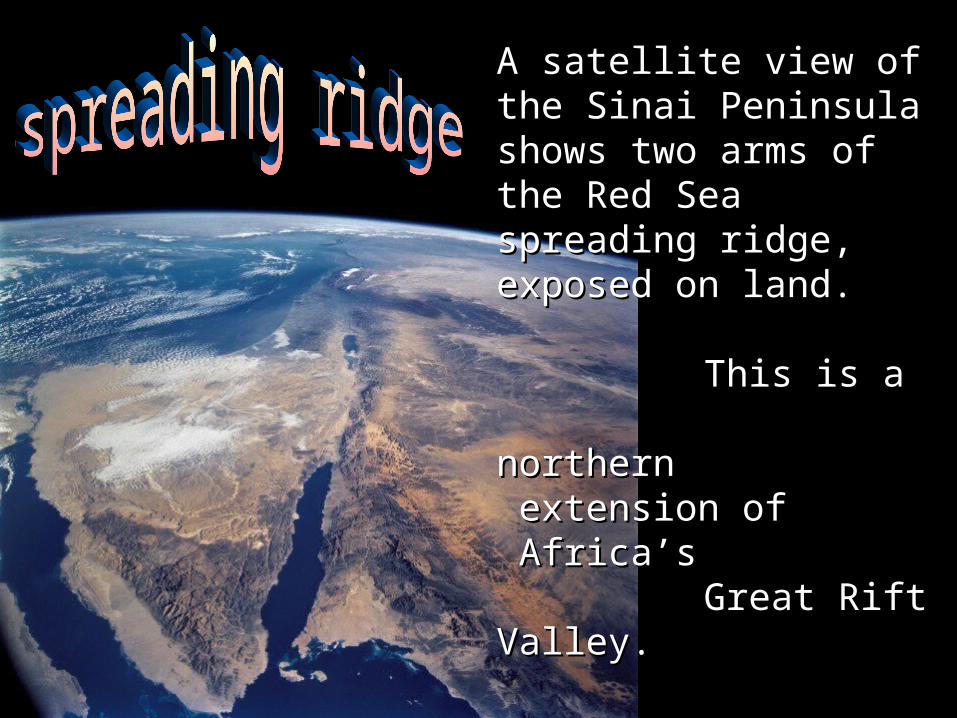
A satellite view of the Sinai A satellite view of the Sinai Peninsula shows two arms Peninsula shows two arms of the Red Sea spreading of the Red Sea spreading ridge, exposed on land. ridge, exposed on land.
This is a This is a northern northern extension of extension of Africa’s Africa’s Great Rift Valley.Great Rift Valley.
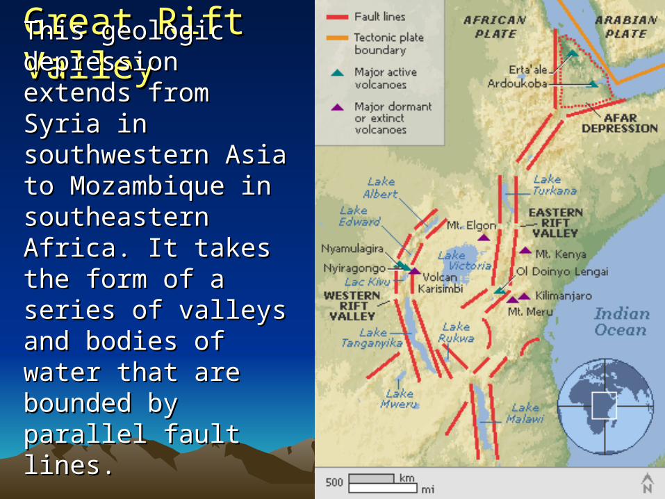
Great Rift ValleyGreat Rift ValleyThis geologic This geologic depression extends depression extends from Syria in from Syria in southwestern Asia to southwestern Asia to Mozambique in Mozambique in southeastern Africa. southeastern Africa. It takes the form of a It takes the form of a series of valleys and series of valleys and bodies of water that bodies of water that are bounded by are bounded by parallel fault lines.parallel fault lines.

The Great The Great Rift ValleyRift Valley
The Great Rift The Great Rift Valley is widening, Valley is widening, in the process in the process causing many causing many volcanic eruptions volcanic eruptions and earthquakes in and earthquakes in the area.the area.
plates dive beneath platesplates dive beneath plates
The Atlantic Ocean is getting larger as the The Atlantic Ocean is getting larger as the Western Hemisphere moves away from Europe Western Hemisphere moves away from Europe and Asia. The Pacific Ocean, on the other hand, and Asia. The Pacific Ocean, on the other hand, is becoming smaller.is becoming smaller.
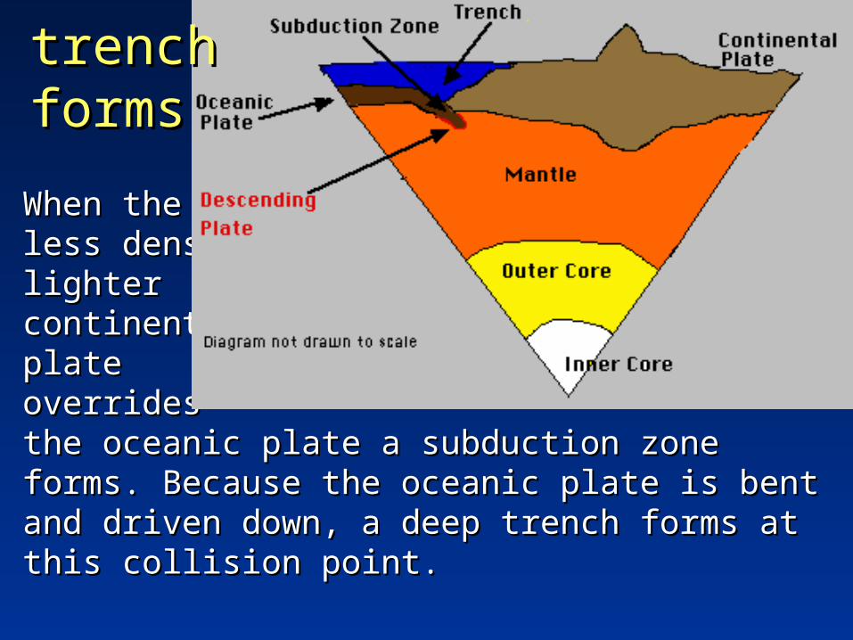
When the When the less dense, less dense, lighter lighter continental continental plate plate overrides overrides the oceanic plate a subduction zone forms. the oceanic plate a subduction zone forms. Because the oceanic plate is bent and driven Because the oceanic plate is bent and driven down, a deep trench forms at this collision point. down, a deep trench forms at this collision point.
trench trench formsforms

The island of Saipan rises more than 36,000 feet above the floor of the trench. On the floor of the trench the water pressure is more than 7 tons per square inch.
Marianas Marianas TrenchTrench
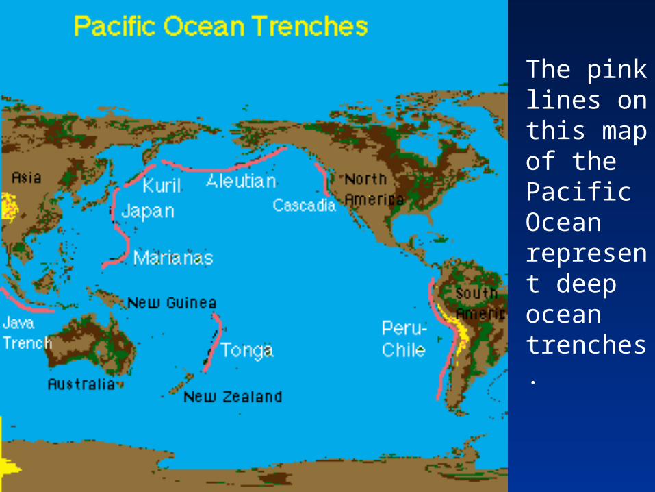
The pink lines on this map of the Pacific Ocean represent deep ocean trenches.

ocean ocean floorfloor
Earthquake Earthquake occurrence occurrence in different in different plate plate tectonic tectonic settings:settings:
This map of Earth's solid surface shows many of This map of Earth's solid surface shows many of the features caused by plate tectonics. The the features caused by plate tectonics. The oceanic ridges are the spreading centers, oceanic ridges are the spreading centers, creating new oceanic crust. creating new oceanic crust.
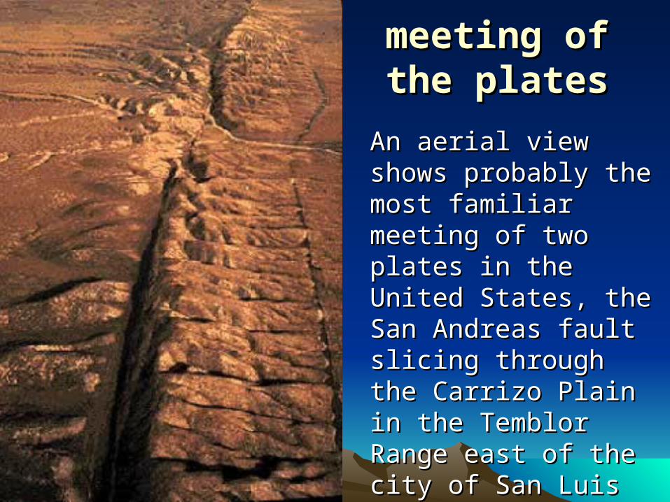
meeting ofmeeting ofthe platesthe plates
An aerial view shows An aerial view shows probably the most probably the most familiar meeting of familiar meeting of two plates in the two plates in the United States, the San United States, the San Andreas fault slicing Andreas fault slicing through the Carrizo through the Carrizo Plain in the Temblor Plain in the Temblor Range east of the city Range east of the city of San Luis Obispo, of San Luis Obispo, CA. CA.
Photograph by Robert E. Wallace, USGS.Photograph by Robert E. Wallace, USGS.
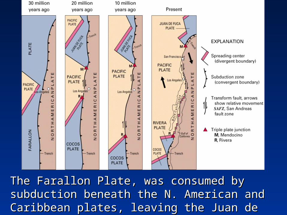
The Farallon Plate, was consumed by subduction The Farallon Plate, was consumed by subduction beneath the N. American and Caribbean plates, beneath the N. American and Caribbean plates, leaving the Juan de Fuca, Rivera, and Cocos leaving the Juan de Fuca, Rivera, and Cocos Plates.Plates.

As the mantle rocks melt they form magma As the mantle rocks melt they form magma which pools. Because the magma is less dense which pools. Because the magma is less dense than the surrounding mantle material it will rise. than the surrounding mantle material it will rise.

forming volcanoesforming volcanoes
A volcano will form if the magma reaches the surface. A volcano will form if the magma reaches the surface. Magma that has reached the surface.Magma that has reached the surface.

KrakatauKrakatau volcano lies in volcano lies in the Sunda the Sunda strait between strait between the islands of the islands of Java and Java and Sumatra. In Sumatra. In about 416 about 416 A.D., caldera A.D., caldera collapse collapse destroyed the destroyed the volcano and volcano and formed a 4-formed a 4-mile wide mile wide caldera.caldera.
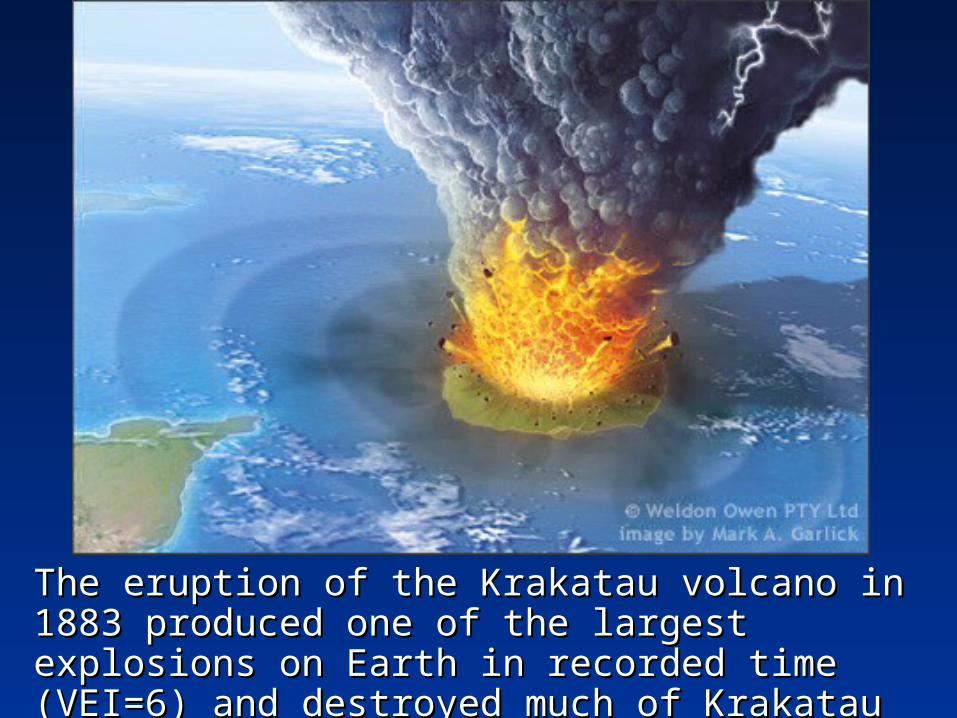
The eruption of the Krakatau volcano in 1883 The eruption of the Krakatau volcano in 1883 produced one of the largest explosions on Earth produced one of the largest explosions on Earth in recorded time (VEI=6) and destroyed much of in recorded time (VEI=6) and destroyed much of Krakatau island.Krakatau island.
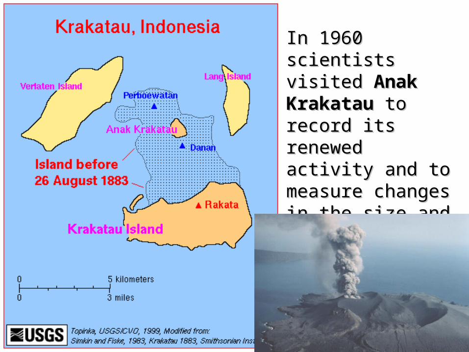
In 1960 scientists In 1960 scientists visited visited Anak Anak KrakatauKrakatau to record to record its renewed activity its renewed activity and to measure and to measure changes in the size changes in the size and shape of the and shape of the island.island.
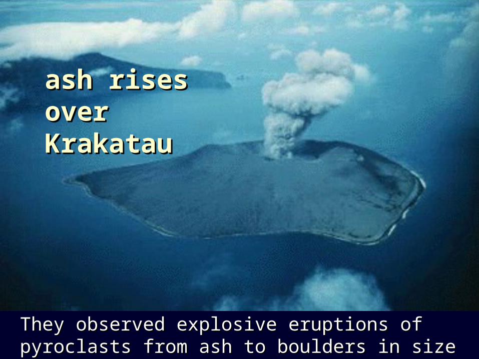
ash rises ash rises over over KrakatauKrakatau
They observed explosive eruptions of pyroclasts They observed explosive eruptions of pyroclasts from ash to boulders in sizefrom ash to boulders in size
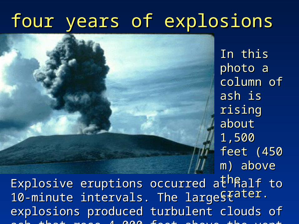
four years of explosionsfour years of explosions
Explosive eruptions occurred at half to 10-Explosive eruptions occurred at half to 10-minute intervals. The largest explosions minute intervals. The largest explosions produced turbulent clouds of ash that rose 4,000 produced turbulent clouds of ash that rose 4,000 feet above the vent.feet above the vent.
In this In this photo a photo a column of column of ash is ash is rising rising about about 1,500 feet 1,500 feet (450 m) (450 m) above the above the crater.crater.

Volcanic ash in the atmosphere contributes to Volcanic ash in the atmosphere contributes to
the brilliance of Pacific Ocean sunsetsthe brilliance of Pacific Ocean sunsets

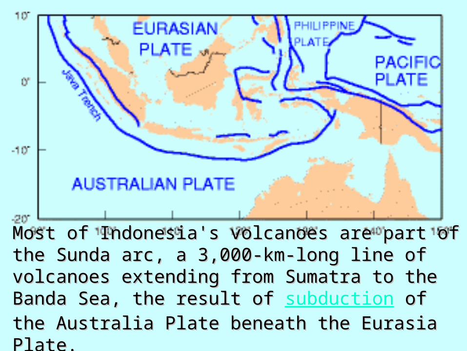
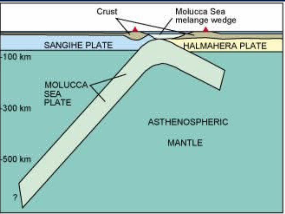
Most of Indonesia's volcanoes are part of the Most of Indonesia's volcanoes are part of the Sunda arc, a 3,000-km-long line of volcanoes Sunda arc, a 3,000-km-long line of volcanoes extending from Sumatra to the Banda Sea, the extending from Sumatra to the Banda Sea, the result of result of subduction of the Australia Plate of the Australia Plate beneath the Eurasia Platebeneath the Eurasia Plate..

Volcanoes in the Banda Sea result from subduction of the Pacific Plate under the Eurasia Plate. Black "teeth" are on the overriding plate. Arrows show direction of movement along major transform faults.
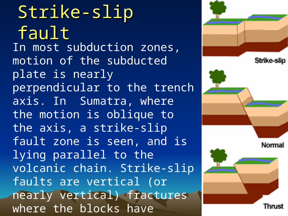
Strike-slip faultStrike-slip faultIn most subduction zones, motion of the subducted plate is nearly perpendicular to the trench axis. In Sumatra, where the motion is oblique to the axis, a strike-slip fault zone is seen, and is lying parallel to the volcanic chain. Strike-slip faults are vertical (or nearly vertical) fractures where the blocks have mostly moved horizontally.
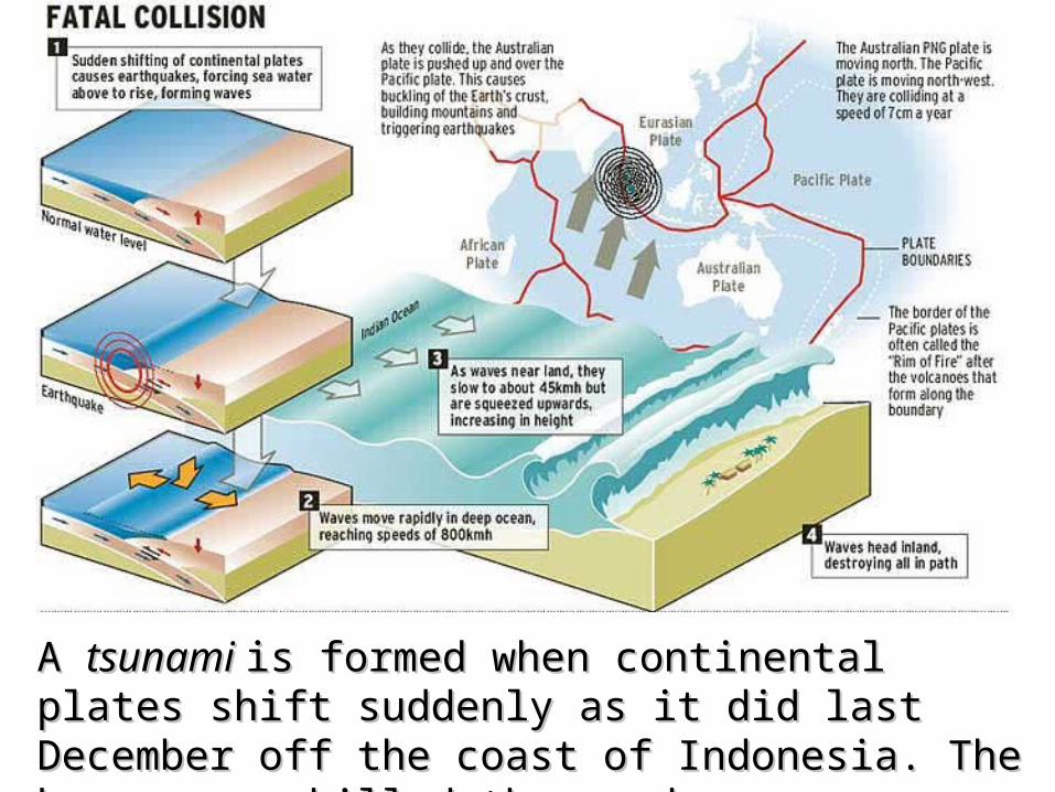
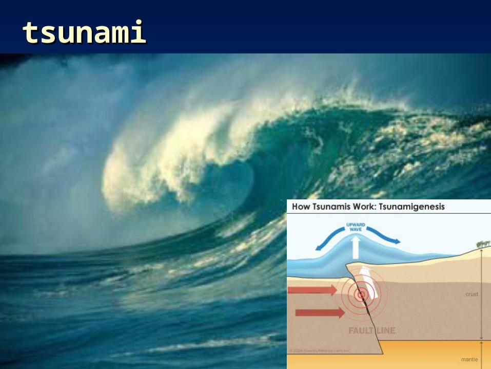
A A tsunami tsunami is formed when continental plates is formed when continental plates shift suddenly as it did last December off the shift suddenly as it did last December off the coast of Indonesia. The huge waves killed coast of Indonesia. The huge waves killed thousands.thousands.
tsunamitsunami
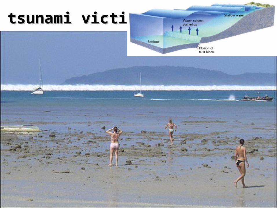
tsunami victimstsunami victims
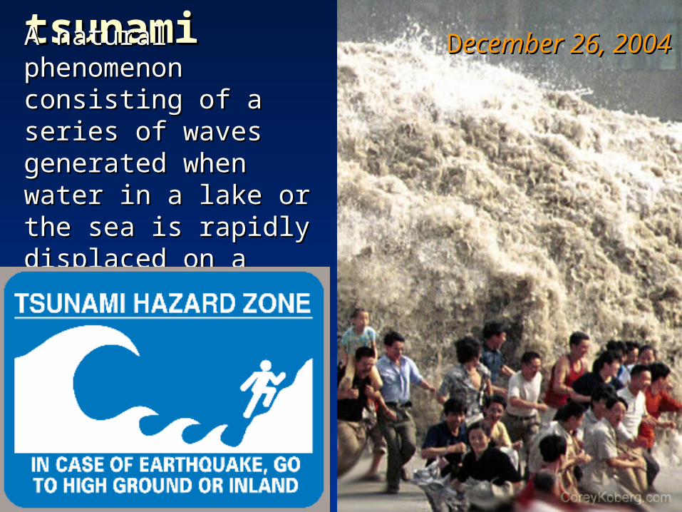
tsunamitsunamiA natural phenomenon A natural phenomenon consisting of a series of consisting of a series of waves generated when waves generated when water in a lake or the water in a lake or the sea is rapidly displaced sea is rapidly displaced on a massive scale. on a massive scale.
DDecember 26, 2004ecember 26, 2004
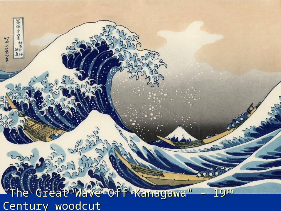
"The Great Wave Off Kanagawa" - 19"The Great Wave Off Kanagawa" - 19 thth Century woodcut Century woodcut
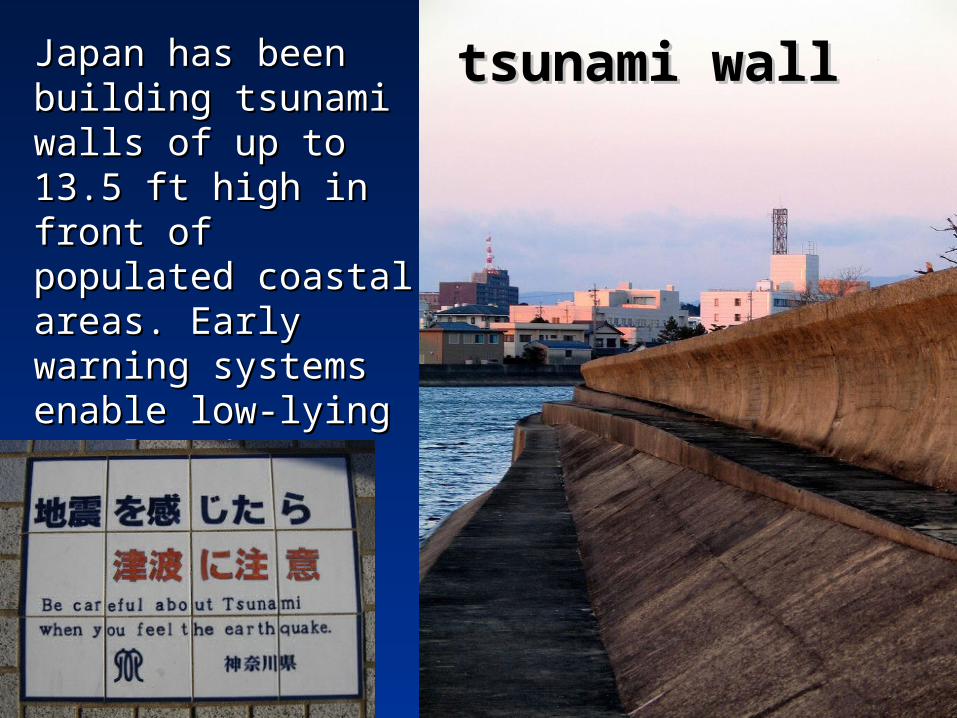
Japan has been Japan has been building tsunami building tsunami walls of up to 13.5 walls of up to 13.5 ft high in front of ft high in front of populated coastal populated coastal areas. Early areas. Early warning systems warning systems enable low-lying enable low-lying populated areas to populated areas to evacuate.evacuate.
tsunami walltsunami wall

Destructive Destructive tsunamis originate tsunamis originate primarily in primarily in subduction zones subduction zones around the Pacific around the Pacific Rim. Model Rim. Model simulations simulations combined with real-combined with real-time tsunami time tsunami measurements will measurements will help assess the help assess the hazard.hazard.
DDeep-oceaneep-oceanAAssessment And ssessment And RReporting ofeporting of TTsunamissunamisSSystemystem
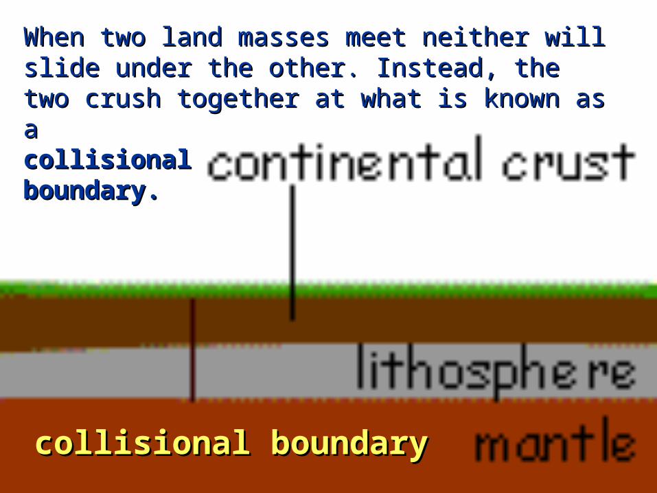
When two land masses meet neither will slide under the other. Instead, When two land masses meet neither will slide under the other. Instead, the two crush together at what is known as a collisional boundary.the two crush together at what is known as a collisional boundary.
When two land masses meet neither will slide under When two land masses meet neither will slide under the other. Instead, the two crush together at what is the other. Instead, the two crush together at what is known as a known as a collisional collisional boundary.boundary.
collisional boundarycollisional boundary

collisional collisional rangesranges
The Himalayas, the highest The Himalayas, the highest mountains in the world, mountains in the world, were created this way. (In were created this way. (In fact, they're still growing.) fact, they're still growing.) So were the European Alps. So were the European Alps. Even the Appalachian Even the Appalachian Mountains formed when two Mountains formed when two land masses came together. land masses came together.
The Appalachian’sThe Appalachian’s Blue Ridge Mts.Blue Ridge Mts.
The Swiss The Swiss AlpsAlps
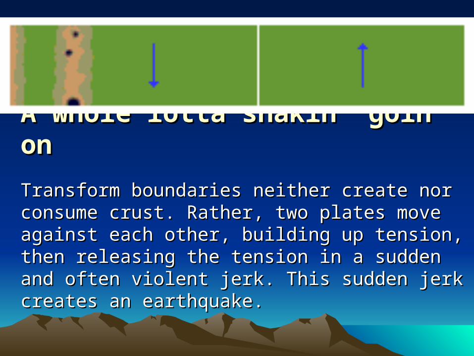
A whole lotta shakin’ goin’ onA whole lotta shakin’ goin’ on
Transform boundaries neither create nor Transform boundaries neither create nor consume crust. Rather, two plates move against consume crust. Rather, two plates move against each other, building up tension, then releasing each other, building up tension, then releasing the tension in a sudden and often violent jerk. the tension in a sudden and often violent jerk. This sudden jerk creates an earthquake.This sudden jerk creates an earthquake.

transform transform boundaryboundary
The San Andreas Fault The San Andreas Fault is undoubtedly the is undoubtedly the most famous transform most famous transform boundary in the world. boundary in the world. To the west of the fault To the west of the fault is the Pacific plate, is the Pacific plate, which is moving which is moving northwest. To the east northwest. To the east is the North American is the North American Plate, which is moving Plate, which is moving southeast.southeast.
Photograph by Robert E. Wallace, USGS.Photograph by Robert E. Wallace, USGS.
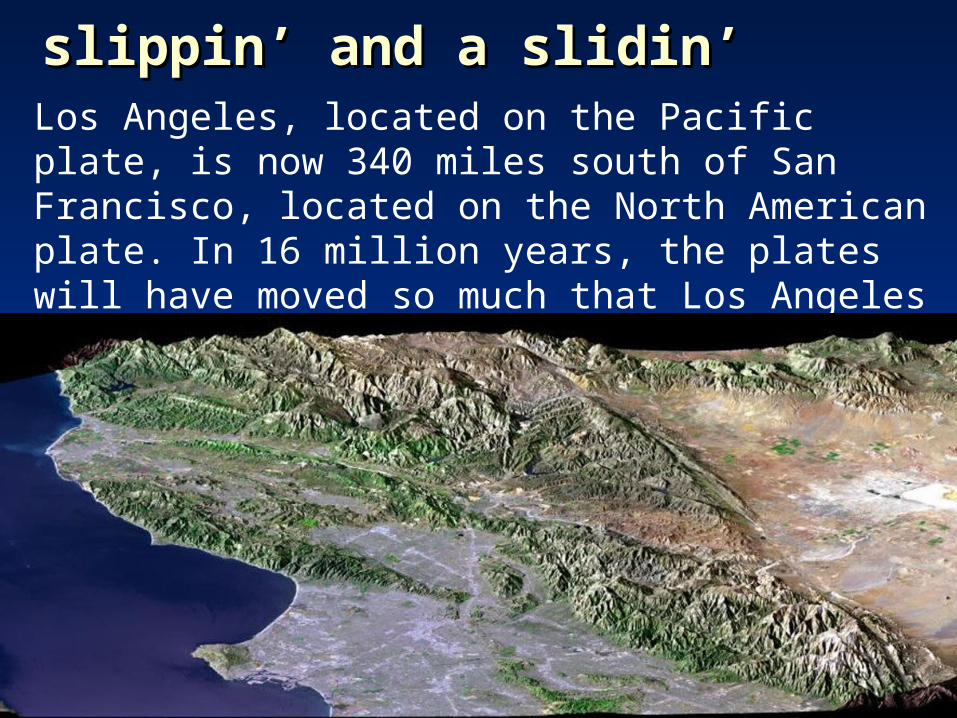
Los Angeles, located on the Pacific plate, is now 340 miles south of San Francisco, located on the North American plate. In 16 million years, the plates will have moved so much that Los Angeles will be north of San Francisco!
slippin’ and a slidin’slippin’ and a slidin’

The vast The vast majority of earthquakes and volcanic eruptions majority of earthquakes and volcanic eruptions occur near plate boundaries, but there are some occur near plate boundaries, but there are some exceptions.exceptions.
Hawaii Hawaii formsforms
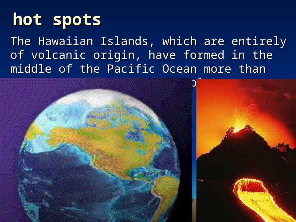
hot spotshot spotsThe Hawaiian Islands, which are entirely of The Hawaiian Islands, which are entirely of volcanic origin, have formed in the middle of the volcanic origin, have formed in the middle of the Pacific Ocean more than 3,200 km from the Pacific Ocean more than 3,200 km from the nearest plate boundary.nearest plate boundary.
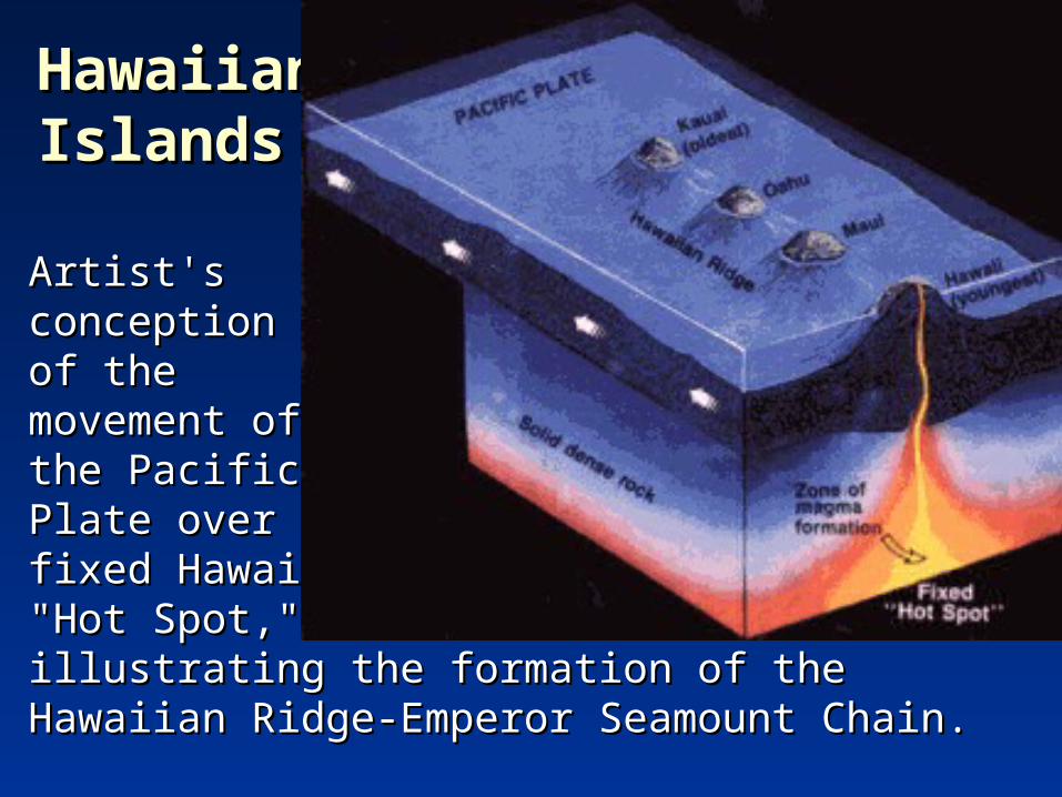
Artist's Artist's conception conception of the of the movement of movement of the Pacific the Pacific Plate over the Plate over the fixed Hawaiian fixed Hawaiian "Hot Spot," "Hot Spot," illustrating the formation of the Hawaiian Ridge-illustrating the formation of the Hawaiian Ridge-Emperor Seamount Chain.Emperor Seamount Chain.
Hawaiian Hawaiian IslandsIslands
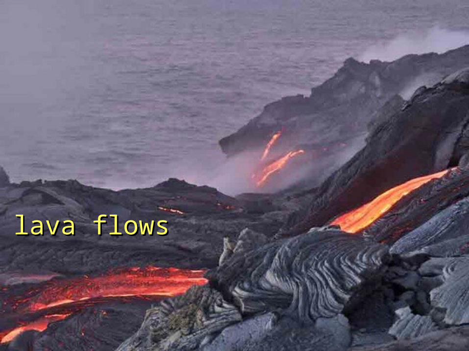
lava flowslava flows

LinksLinkshttp://www.stockpix.com/stock/nature/geology/9774.jpghttp://www.cnmi-guide.com/info/sketches/marianastrench.htmlhttp://www.transalpriders.com/images/photo-swiss-alps-mountain-magic.jpghttp://volcano.und.nodak.edu/vwdocs/vwlessons/lessons/Earths_layers/Earths_layers1.htmlhttp://volcano.und.nodak.edu/vwdocs/volc_images/southeast_asia/indonesia/krakatau.htmlhttp://www.pbs.org/wgbh/aso/tryit/tectonics/transform.htmlhttp://fonds-ancien.ensmp.fr/Ouvrages_rem/Images/krakatoa.jpghttp://platetectonics.pwnet.org/story_tectonics/north_american/types_of_plates.htmhttp://platetectonics.pwnet.org/story_tectonics/north_american/types_of_plates.htmhttp://scign.jpl.nasa.gov/learn/eq.htmhttp://scign.jpl.nasa.gov/learn/eq.htmhttp://www.columbia.edu/itc/ldeo/mutter/jcm/Topic3/Topic3.htmlhttp://www.columbia.edu/itc/ldeo/mutter/jcm/Topic3/Topic3.htmlhttp://www.intute.ac.uk/sciences/hazards/volcano_krakatau.htmlhttp://www.intute.ac.uk/sciences/hazards/volcano_krakatau.htmlhttp://www.privateislandsblog.com/2007/07/26/krakatau-a-natural-wonder-of-the-world-with-http://www.privateislandsblog.com/2007/07/26/krakatau-a-natural-wonder-of-the-world-with-an-explosive-past/an-explosive-past/