vol. 4, issue 8, august 2015 gully erosion-induced …ankpa plateau of the anambra basin, nigeria,...
TRANSCRIPT
ISSN(Online) : 2319-8753 ISSN (Print) : 2347-6710
International Journal of Innovative Research in Science,
Engineering and Technology (An ISO 3297: 2007 Certified Organization)
Vol. 4, Issue 8, August 2015
Copyright to IJIRSET DOI:10.15680/IJIRSET.2015.0408174 6864
Gully Erosion-Induced Land Degradation on the Idah-Ankpa Plateau of the Anambra
Basin, Nigeria
Oparaku, L.A.1 Enokela, S.O.2, Akpen, G.D.2 Department of Agricultural and Environmental Engineering, University of Agriculture, Makurdi, Nigeria.1,2.
Department of Civil Engineering, University of Agriculture, Makurdi, Nigeria.3
ABSTRACT: Forty three gullies were sampled and measured on the three geological formations underlying the Idah-Ankpa Plateau of the Anambra Basin, Nigeria, to define their morphometry as well as their roles in the degradation of the plateau lands. The three geological formations comprise the Ajalli Sandstones (AS), the Upper Coal Measures (UCM), and the Lower Coal Measures (LCM). Of the forty three gullies studied, 37, 5, and 1 were located on the AS, UCM, and LCM respectively. Descriptive statistics of mean, standard deviation, and coefficient of variation were used to describe their morphometric characteristics such as length (L), average depth (D), average width (W), average volume (V), average cross sectional area (A), and the form factor (W/D). Findings indicate that the mean L = 452.27, 361.66, and 400.00 m; mean D = 6.49, 5.96, and 5.00m; and mean W = 7.95, 6.23, and 3.00 m on the AS, UCM, and LCM respectively. These translate to standard deviation values of L = 322.12 and 200.52; D = 3.47 and 4.91; and W = 5.53 and 0.87 with a coefficient of variation of L = 71.22 and 55.44; D = 532.47 and 82.38; and W = 69.56 and 13.97 on the AS and UCM respectively. The respective W/D ratios on the AS, UCM and LCM were 1.46, 0.91, and 0.60. The size and population of the gullies on the AS show that the greatest amount of sediment pollution occurs on this formation. In addition, a W/D ratio of 1.46 indicates that the surface soils are degraded (eroded) more than the sub-soils on the AS. On the other hand, a W/D ratio of 0.91 on the UCM shows that the sub-soils are slightly more degraded and degradable than the surface soils. Furthermore, a W/D of 0.60 of the only existing gully on the LCM reveals that the sub-soils are more erodible than the surface soils. Whereas land management practices shall be geared towards preventing accelerated erosion on the UCM and LCM, government shall intensify more efforts in the control of gullies on the AS. KEYWORDS; Idah Ankpa Plateau, Anambra Basin, Gullies, morphometric characteristic.
I INTRODUCTION
Gully erosion as an environmental problem is widespread in Nigeria and has been reported in all the ecological regions of the country. IRIN [1] reported that the Federal Ministry of Agriculture estimates that about 35 million tones of soil are washed away annually from the nation’s land surfaces by soil erosion. Even so, most reports in the literature on the gullies actually studied and controlled come from the southeastern part of the country where a high population density; high relief; steep slopes; deforestation; a humid tropical climate; and a deeply weathered, friable sandstones and shales combine to predispose the soil to rapid gullying processes. The rate of advance of some gullies in the southeast are estimated to range from 20 to 50 myr-1, and some gullies are 5 to 10 m deep and 10 to 100 m wide (Egboka and Okpoko, Oparaku, [2],[3]). Hudec et al.[4] outlined the causes of gully erosion in the southeast to include unevenly compacted soils; human, animal, and vehicular traffic; and improperly designed and installed culverts. The ecological zone of Nigeria known as the Idah-Ankpa Plateau (IAP) is also beset by a proliferation of gullies, especially on the most erodible Ajalli Sandstones’ geological sediments (Oparaku et al.,[5]). Among the impacts of gully erosion in the study area is siltation, leading to the disappearance of a long reach of the Anambra River near
ISSN(Online) : 2319-8753 ISSN (Print) : 2347-6710
International Journal of Innovative Research in Science,
Engineering and Technology (An ISO 3297: 2007 Certified Organization)
Vol. 4, Issue 8, August 2015
Copyright to IJIRSET DOI:10.15680/IJIRSET.2015.0408174 6865
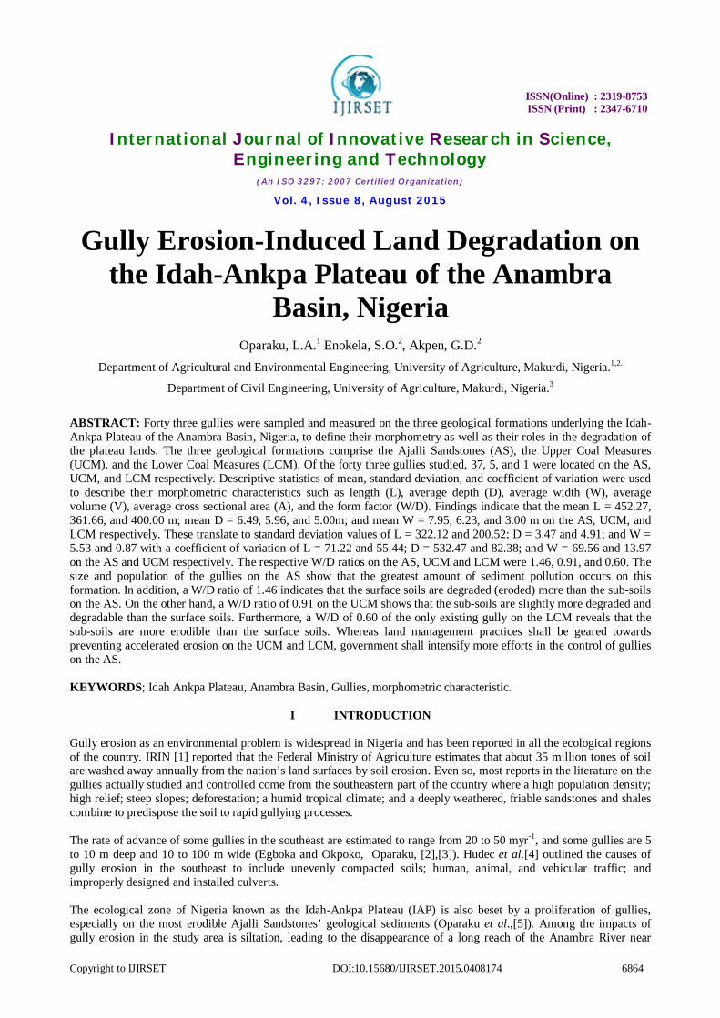
Ankpa. Also many urban drainage structures, electricity and telephone structures, high-value buildings, and highway roadside drains and culverts have been lost to gully erosion at Otukpa, Ankpa, Ayangba, Dekina, Ogwulawo, Ofu and Idah. In addition, in the rural areas, gullies have dissected and voided farmlands, caused the disappearance of village water supply sources, and degraded inter-and intra-communal roadways (Figure 1).
A
B
C
Figure 1: Some Land Devastations Caused by Soil Erosion on the IAP (A) An urban roadway undermined by soil erosion at Dekina. (B) An intercity roadway overtaken by eroded sediments between Otukpa and Orokam. (C) A portion of a landscape degraded by gully erosion at Ankpa.
ECAN [6] reported that land degradation in the form of gully erosion on the Idah-Ankpa Plateau has been most spectacular starting from the 1970s. The proliferation of gullies in this location is an unacceptable development considering that the inhabitants live by the produce of the land. In other words, subsistence agriculture is the mainstay of the indigenous communities, providing employment for a sizable number of the rural population. This study, therefore, was an attempt to assess the role of gully erosion on the degradation of the geological sediments of the Idah-Ankpa Plateau.
II THE STUDY AREA
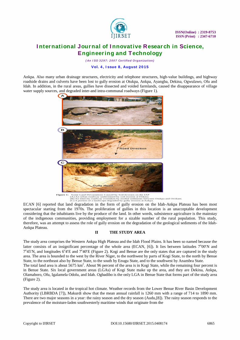
The study area comprises the Western Ankpa High Plateau and the Idah Flood Plains. It has been so named because the latter consists of an insignificant percentage of the whole area (ECAN, [6]). It lies between latitudes 7o00N and 7o45N, and longitudes 6o4E and 7o40E (Figure 2). Kogi and Benue are the only states that are captured in the study area. The area is bounded to the west by the River Niger, to the northwest by parts of Kogi State, to the north by Benue State, to the northeast also by Benue State, to the south by Enugu State, and to the southwest by Anambra State. The total land area is about 5675 km2. About 96 percent of the area is in Kogi State, while the remaining four percent is in Benue State. Six local government areas (LGAs) of Kogi State make up the area, and they are Dekina, Ankpa, Olamaboro, Ofu, Igalamela Odolu, and Idah. Ogbadibo is the only LGA in Benue State that forms part of the study area (Figure 2). The study area is located in the tropical hot climate. Weather records from the Lower Benue River Basin Development Authority (LBRBDA [7]), Makurdi show that the mean annual rainfall is 1260 mm with a range of 714 to 1890 mm. There are two major seasons in a year: the rainy season and the dry season (Audu,[8]). The rainy season responds to the prevalence of the moisture-laden southwesterly maritime winds that originate from the
ISSN(Online) : 2319-8753 ISSN (Print) : 2347-6710
International Journal of Innovative Research in Science,
Engineering and Technology (An ISO 3297: 2007 Certified Organization)
Vol. 4, Issue 8, August 2015
Copyright to IJIRSET DOI:10.15680/IJIRSET.2015.0408174 6866
9 00No 9 30No 10 00No 10 30No8 00No
Figure 2: The Study Area (The Idah-Ankpa Plateau)
SettlementsStudy Area Boundary RoadsContoursRivers
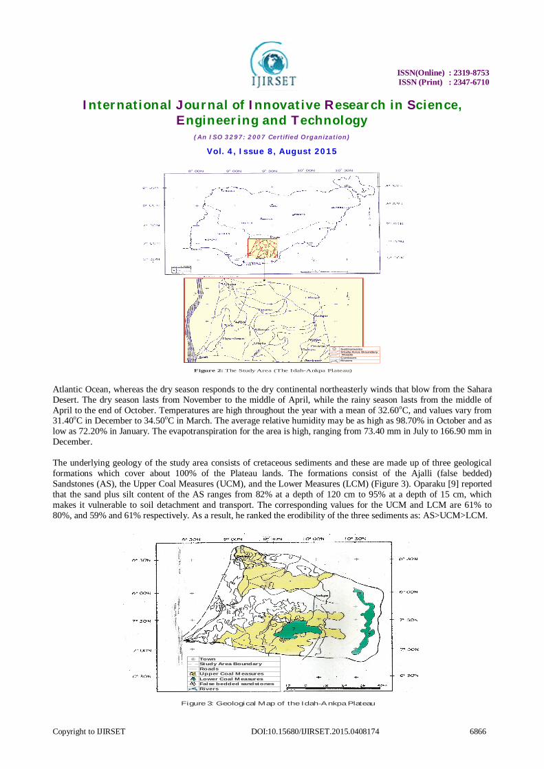
Atlantic Ocean, whereas the dry season responds to the dry continental northeasterly winds that blow from the Sahara Desert. The dry season lasts from November to the middle of April, while the rainy season lasts from the middle of April to the end of October. Temperatures are high throughout the year with a mean of 32.60oC, and values vary from 31.40oC in December to 34.50oC in March. The average relative humidity may be as high as 98.70% in October and as low as 72.20% in January. The evapotranspiration for the area is high, ranging from 73.40 mm in July to 166.90 mm in December. The underlying geology of the study area consists of cretaceous sediments and these are made up of three geological formations which cover about 100% of the Plateau lands. The formations consist of the Ajalli (false bedded) Sandstones (AS), the Upper Coal Measures (UCM), and the Lower Measures (LCM) (Figure 3). Oparaku [9] reported that the sand plus silt content of the AS ranges from 82% at a depth of 120 cm to 95% at a depth of 15 cm, which makes it vulnerable to soil detachment and transport. The corresponding values for the UCM and LCM are 61% to 80%, and 59% and 61% respectively. As a result, he ranked the erodibility of the three sediments as: AS>UCM>LCM.
TownStudy Area BoundaryRoadsUpper Coal MeasuresLower Coal MeasuresFalse bedded sandstonesRivers
Figure 3: Geological Map of the Idah-Ankpa Plateau
ISSN(Online) : 2319-8753 ISSN (Print) : 2347-6710
International Journal of Innovative Research in Science,
Engineering and Technology (An ISO 3297: 2007 Certified Organization)
Vol. 4, Issue 8, August 2015
Copyright to IJIRSET DOI:10.15680/IJIRSET.2015.0408174 6867
Preez and Barber [10] stated that the UCM and LCM are each about 70 m in thickness, whereas the AS is homogenous to a depth of 170 m. Onuoha and Uma [11] and Hudec et al. [12] have observed that the Ajalli Sandstones of the Idah-Ankpa Plateau, the Nanka Sands, and the Ajalli Sandstones of the southeastern States of Nigeria where the most destructive gully erosion activities are in occurrence bear striking textural similarities. The geomorphology of the area consists of Ankpa Plateau and the piedmont which lie over sandstones, but differentiated in the deep valleys. The Anambra River, which is a tributary of the River Niger, is the main drainage basin of the area. However, there are other smaller streams which drain through the area and empty into the Anambra River and these include Eruku, Akura and Okulu. The parent materials of the soils of the area are predominantly cretaceous sandstones. Bennett et al. [13] reported that the horizons have similar characteristic and arrangements. The soils are deep, well drained and frequently red or reddish brown in colour with sandy surface horizons occurring on the crests of interfluves and on the upper and middle slopes. Subsistence agriculture is practised in the area using hand tools to produce the major food crops such as yams, cassava, maize, groundnuts, millet, cowpeas, guinea corn, okra, pepper, amaranthus, etc. Ridging up-and-down steep slopes on the fragile Ajalli Sandstones sediments is a common method of land preparation and this often gives rise to erosion channels that lead to the formation of gullies. The commonest livestock kept in the area include goats, sheep, poultry, and the dwarf (muturu) cattle.
III MATERIALS AND METHODS
Field trips were undertaken at different times from January to July, 2011 to study the extent of gully erosion-induced land degradation occurring on the Idah-Ankpa Plateau of the Anambra Basin. An aspect of this study involved the determination of the morphometric characteristics of the gullies. The population of gullies studied comprised all the gullies in occurrence on the Plateau lands. However, realizing that it was unwieldy to study all the individual gullies in this area, a sample was taken from each formation and studied, the size of which depended on the population on that geological unit. Thirty seven gullies were sampled and measured on the AS, five on the UCM, and one on the LCM. Of the 37 gullies sampled on the AS, 16 were treated, 14 were inactive, and 7 were active. The dimensions of the 16 treated gullies on the AS were obtained from the LBRBDA [7], and the remaining 21 gullies on the AS, the five on the UCM and the one on the LCM were measured in the field using the method described by Iorkua [14]. The gully dimensions were the length (L), average depth (D), and the average width (W). Other variables computed from these three parameters were the average volume (V), average cross sectional area (CSA) (A), and the form factor (W/D). This data set of six was analysed using descriptive statistics to determine their influence on land degradation on the geological sediments that underlie the area.
IV RESULTS AND DISCUSSION
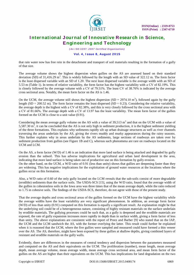
Tables 1, is the descriptive statistics of the parameters of the gullies formed on the AS. The total length of the gullies is 16,700.00m with the average length of the gullies on the AS been 452.27 m The lengths on the two formations range from 45.22 to 1,500 m . Other morphometric parameters evaluated are found in table1.

ISSN(Online) : 2319-8753 ISSN (Print) : 2347-6710
International Journal of Innovative Research in Science,
Engineering and Technology (An ISO 3297: 2007 Certified Organization)
Vol. 4, Issue 8, August 2015
Copyright to IJIRSET DOI:10.15680/IJIRSET.2015.0408174 6868
Table 1: Descriptive Statistics of the 37 Gullies Formed on the Ajalli Sandstones Geological Formation Gully morphometry Unit Total RG X SD CV Length (L) M 16,700.00 1,500.00 452.27 322.12 71.22 Average depth (D) M 240.06 1.05 – 16.30 6.49 3.47 53.47 Average width (W) M 294.04 2.20 – 30.00 7.95 5.53 69.56 Average Volume (V) m3 146 x 104 1,277.92 – 540,000.00 39.513.00 31,416.29 79.51 Average CSA(A) m2 2,300.00 3.26 – 360.00 62.16 24.09 38.76
Form factor DW _ 54.02 0.25 – 6.26 1.46 1.20 82.19
RG = Range, X = Mean, SD = Standard Deviation, CV = Coefficient of Variation (%), and CSA = Cross Sectional Area Tables 2, presents the descriptive statistics of the parameters of the gullies formed on the UCM. The total length of the gullies in the UCM was 1808.32m with the average been 361.66 m. and in the range of 18.25 to 500.00 m Tables 2. Morphometric parameters like average depth, average width, average volume and cross sectional area were also evaluated as presented in table 2.
Table 2: Descriptive Statistics of the Five Gullies Formed on the Upper Coal Measures Geological Formation.
Gully morphometry Unit Total RG X SD CV Length (L) M 1808.32 18.32 – 500.00 361.66 200.52 55.44 Average depth (D) M 29.82 2.70 – 14.62 5.96 4.91 82.38 Average width (W) M 31.17 2.30 – 18-87 6.23 0.87 13.97 Average Volume (V) m3 27.900.00 2173.50 – 10,000.00 5,587.30 2974.10 53.23 Average CSA(A) m2 324.84 6.21 – 275.88 64.97 53.05 81.66
Form Factor DW _ 4.55 0.71 – 1.30 1.91 0.23 25.27
RG = Range, X = Mean, SD = Standard Deviation, CV = Coefficient of Variation (%), and CSA = Cross Sectional Area Tables3 is the descriptive statistics of the parameters of the gully formed on the LCM. The length of the only gully formed on the LCM which was initiated by coal mining activities on this formation is 400.00 m, other morphometric parameterwere evaluated and presented in Table 3.
Table 3: Morphometry of the only gully formed on the Lower Coal Measures geological formation.
Morhometry characteristic Dimension Length, (L ) (m) 400.00 Average depth,( D ) (m) 5.00 Average width, (W ) (m) 3.00 Average volume, V (m3) 6,000.00 Average Crossectional Area, A(m2) 15.00 Form factor, W/D 0.60 The mean length of the gullies on the AS is greater than each of those on the UCM and LCM. However, the length of the only gully on the LCM is greater than the mean length of the gullies on the UCM. This is a classic example of the effect of accelerated erosion on an otherwise highly resistant formation. This strange but restricted phenomenon is attributable to human activities on the coal mine site at the LCM which have so loosened the erosion-resistant material
ISSN(Online) : 2319-8753 ISSN (Print) : 2347-6710
International Journal of Innovative Research in Science,
Engineering and Technology (An ISO 3297: 2007 Certified Organization)
Vol. 4, Issue 8, August 2015
Copyright to IJIRSET DOI:10.15680/IJIRSET.2015.0408174 6869
that rain water now has free rein in the detachment and transport of soil materials resulting in the formation of a gully of that size. The average volume shows the highest dispersion when gullies on the AS are assessed based on their standard deviation (SD) of 31,416.29 m3. This is widely followed by the length with an SD value of 322.12 m. The form factor is the least dispersed variable with an SD of 1.20. The next least dispersed variable is the average width with an SD of 5.53 m (Table 1). In terms of relative variability, the form factor has the highest variability with a CV of 82.19%. This is closely followed by the average volume with a CV of 79.51%. The least CV of 38.76% is indicated by the average cross sectional area. Notably, the mean form factor on the AS is 1.46. On the UCM, the average volume still shows the highest dispersion (SD = 2974.10 m3), followed again by the gully length (SD = 200.52 m). The form factor remains the least dispersed (SD = 0.23). Considering the relative variability, the average depth is the highest with a CV of 82.38%, and this is very closely followed by the cross sectional area with a CV of 81.66%. The average depth with a CV of 13.97 has the least variability. The mean form factor of the gullies formed on the UCM is close to a unit value (0.91). Considering the mean average gully volume on the AS with a value of 39,513 m3 and that on the UCM with a value of 5,587.30 m3, it can be concluded that the AS is not only high in sediment production, it is the highest sediment yielding of the three formations. This explains why sediments rapidly silt up urban drainage structures as well as river channels traversing the areas underlain by the AS, giving the rivers muddy and murky appearances during the rainy seasons. This further explains why in areas underlain by the AS sediments, large sections of roadways are taken over by sediment production from gullies (see Figure 1B and C), whereas such phenomena are rare on roadways located on the UCM and LCM. On the AS, a form factor (W/D) of 1.46 is an indication that more land surface is being attacked and degraded by gully erosion than the subsoil. This has adverse implications for agricultural and urban land development in the area, indicating that more land surface is being taken out of productive use on this formation by gully erosion. On the other hand, on the UCM, a W/D ratio of 0.91 (less than unity) shows that gullies are deepening faster than they are widening. This has negative implications for the exploitation of ground water resources at the locations where the gullies occur on this formation. Also, a W/D ratio of 0.60 of the only gully located on the LCM reveals that the sub-soils consist of more degradable (erodible) sediments than the surface soils. The USDA-SCS [15], using the W/D ratio, found that the average width of the gullies in cohesionless soils in the Iowa area was three times that of the mean average depth, while the ratio reduced to 1.75 in cohesive soils. The findings of the USDA-SCS, therefore, do not agree with those of the present study. That the average depths and cross sectional areas of the gullies formed on the UCM have the highest variability while the average widths have the least variability are very significant phenomenon. In addition, an average form factor (W/D) of less than unity (0.91) computed on this formation is equally a significant result. An explanation might be that the underlying soil could be of a heterogeneous nature, consisting of highly resistant materials on the surface underlain by erodible materials. The gullying processes could be such that, as a gully is deepened and the erodible materials are exposed, the rate of gully expansion increases more rapidly in depth than in surface width, giving a form factor of less than unity. The above explanations are consistent with the report of Preez and Barber [9] who stated that on the IAP, the UCM and the LCM sandwich the AS, with the former overlying the latter. This result could further be explained when it is reasoned that the UCM, where the five gullies were sampled and measured could have formed a thin veneer over the AS. The AS, therefore, might have been exposed by these gullies at shallow depths, giving combined layers of resistant and erodible materials on the gully walls. Evidently, there are differences in the measures of central tendency and dispersion between the parameters measured and computed on the AS and their equivalents on the UCM. The proliferation (number), mean length, mean average depth, mean average volume, mean average width, mean average cross sectional area, and mean form factor of the gullies on the AS are higher than their equivalents on the UCM. This has implications for land degradation on the two
ISSN(Online) : 2319-8753 ISSN (Print) : 2347-6710
International Journal of Innovative Research in Science,
Engineering and Technology (An ISO 3297: 2007 Certified Organization)
Vol. 4, Issue 8, August 2015
Copyright to IJIRSET DOI:10.15680/IJIRSET.2015.0408174 6870
geological formations. The implication is that in the study area, the AS is more degraded and more prone to degradation by gully erosion than the UCM, and by extension, the LCM. The LCM is therefore, the least susceptible to gully erosion-induced degradation.
V CONCLUSIONS
Gully erosion is a serious environmental problem on the Ajalli Sandstones’ geological formation on the Idah-Ankpa Plateau of the Anambra Basin. The mean length, mean average depth, and mean average width predispose the soil to a high rate of sediment production that submerge the highways and silt up water bodies and channels. In addition, the mean average gully width is greater than the mean average gully depth by a factor of 1.46. This shows that on this formation, the land surface is being degraded (attacked) than the subsoil by gully erosion. This finding, when considered together with the proliferation and size of the gullies on this formation, leads to the conclusion that gully erosion is a threat to agricultural and urban land development on the areas underlain by the Ajalli Sandstones. On the other hand, gullies formed on the Upper Coal Measures’ geological formation are few and far between and, therefore, do not constitute any serious sedimentation problems on the highways and water bodies in their areas of occurrence. However, the mean average gully width is greater than the mean average depth on this formation by a factor of 0.91. This shows that gullies formed on the Upper Coal Measures degrade the subsoil more than they do the surface soil. The implication is that gullies on this formation pose a threat to ground water exploitation in the locations where they occur. The sub-soils of the Lower Cola Measures are more degradable than the surface soils. Measures shall be taken to minimize accelerated erosion on the UCM and LCM, and government shall commit more resources and efforts in the control of gully erosion on the area underlain by the Ajalli Sandstone’s geological sediments.
REFERENCES
[1] IRIN. Nigeria: IRIN special report on environmental challenges,2008 [2] Egboka, B.C.E. and Okpoko, E.J. Gully erosion in the Agulu Nanka region of Anambra State, Nigeria. Int. Assoc. of Hydrol. Sci.
Wallingford, England. Vol. 144. 1984 [3] Oparaku, L.A. Remedial Erosion Control Measures for Nekede Town, Imo State, Nigeria. A feasibility report submitted to the Owerri
West Local Government Council, Imo State, Nigeria.1999 [4] Hudec, P.P.; Simpson, F.; Akpokodje, E.G.; and Umenweke, M.O. Termination of gully processes, Southeastern Nigeria. Proceedings of
the Eight Federal Interagency Sedimentation Conference (April 2 – 6) Reno. NY. USA. 2006. [5] Oparaku, L.A.; Iorkua, S.A.; and Joel, M. Gully Erosion on the Idah-Ankpa Plateau of the Anambra Basin, Nigeria: Some Field
Observations. In: National Colloquium on Frontiers in Environmental Research and Sustainable Developmen. In print. 2014 [6] ECAN. Gully Erosion Control Measures for Ankpa Town. Federal Ministry of Agriculture, Nigeria.1982 [7] LBRBDA Weather Report of the Lower Benue River Development Authority, Makurdi, Benue State, Nigeria. 2011. [8] Audu, E.BA Descriptive Analysis of Rainfall for Agricultural Planning in Lokoja Local Government Area of Kogi State, Nigeria.
International Journal of Science and Technology Volume 2 No.12, December 2012 ISSN 2224-3577 . 2012. [9] Oparaku, L.A. (2014). Gully Erosion on the Idah-Ankpa Plateau of the Anambra Basin, Nigeria. A Ph.D thesis submitted to the
Department of Geography and Planning, University of Jos, Plateau State, Nigeria. [10] Preez, J.W. and Barber, W. The distribution and chemical quality of ground water in Northern Nigeria. Geological Survey of Nigeria,
Bulletin 36. 1965. [11] Onuoha, K.M.S. and Uma, K.O. An appraisal of recent geologic and hydrologic hazards in Nigeria. In: Natural and Man-made Hazards,
Kluwer Academic Publisers, The Netherlands. 1988. [12] Hudec, P.P.; Simpson, F.; Akpokodje, E.G.; and Umenweke, M.O.; and Ondrasik, MGully erosion of coastal plain sediments of Nigeria.
In: D. Moore and O. Hunger (eds) Proc. Eight International Congress, Int. Assoc. for Engineering Geology and Environment, 21 – 25 Sept. Vancouver, Canada, A.A. Balkema, Rotterdam, 1835 – 1841. 1998.
[13] Bennett, J.G.; Hill, I.D.; Howard, W.J.; Hutcheon, A.A.; Rackham, L.J.; and Wood, A.W. (1976). Interim Report on the Landforms, Soils, and Vegetation of the Benue Valley.
[14] Iorkua, A.S. A Gully in the North Bank area of Makurdi, Benue State, Nigeria. An unpublished Ph.D thesis submitted to the University of Ibadan, Nigeria. April, 1999.
[15] USDA-SCS Technical release No.32 (Geology). US Department of Agriculture, Washington, DC. 125 – 142. 1966.