volcanic cultures of risk: photographing sites of memory1 ... · night-time eruption of sakurajima...
TRANSCRIPT

volcano is intrinsically linked to memory. It shapes the memories of those who visit it, those who study it, and especially those who inhabit its surroundings. For all in-volved, it has a tripartite role: It can act as the archivist, the effacer, or the object of memory – or, sometimes, as all three at once. It is a creator and destroyer of land. It is a site of almost mythological intrigue for some. For others, it is home.A
Volcanic Cultures of Risk: Photographing Sites of Memory1
Richard Roscoe

GE217
A volcano contains within its magma chambers the power to ar-chive. Volcanic eruptions do not have the precision of a library archi-vist filing dusty volumes; however, in burying entire cities volcanoes create historical records of their own. An eruption of the Santorini volcano 3,600 years ago, for instance, buried and preserved the Mi-noan settlement of Akrotiri. This occurred at the time the Minoan culture was thriving in the eastern Mediterranean and the eruption has been linked to its decline (although this theory is somewhat disputed today). The Italian city of Pompeii, meanwhile, is probably the most famous volcanic archive. After the eruption of Vesuvius in the year 79 AD the city remained preserved beneath the ashes, capturing in time what is effectively a snapshot of contemporaneous local culture. In these instances, the volcano as archivist shapes our historical knowledge and memory of these two societies.
As well as preserving memory, though, the volcano can efface the memory of both place and society. The destructive nature of the vol-cano curates sites, selectively scarring and destroying land, erasing history just as easily as it might preserve it. After massive or long-term eruptions, surrounding land may become uninhabitable or un-usable. The Mexican volcano of Paracutin, for example, inundated its surroundings with thick lava flows after forming in the middle of a local farmer’s field in 1943. No longer amenable to agriculture, the area has become the domain of the volcano. Evacuations of vol-canic areas are often brief, but it is not uncommon, as in the case of Montserrat’s Soufrière Hills volcano, for an evacuation to extend for an indefinite period of time. In such cases, communities are at first displaced, then later resettled in fragmentary form. Communal identity is destroyed. Cultural memory can disappear with it.
In addition, the volcano is the object of memory. It is, by virtue of its often spectacular nature, an interesting and memorable site. The volcano attracts tourists, photographers, and filmmakers; it pro-vides a living space for many communities, offering fertile agricul-
1 This essay is based on a speech given by Richard Roscoe. It has been adapted for Global Environment by Maeve Storey.

ReSeaRCh aRtiCleS / RoSCoe 218
tural land, tourism related employment, and energy resources. The cultural memory (or lack thereof ) that these communities retain of past volcanic activity can play a crucial role in their decision to live in such high-risk areas; volcanoes may not be considered danger-ous or the hazards presented by volcanoes may not be recognized. Many volcanoes have not erupted in recorded history and may not even have an easily recognizable volcanic form due to erosion or forestation: Pinatubo volcano in the Philippines, hardly distinguish-able from the surrounding terrain and covered in forest, produced the second biggest eruption of the twentieth century. Over 800 peo-ple were killed. A certain mode of non-memory encouraged people to settle around the volcano, the eventual eruption of which led to their displacement, even their demise.
Many forms of natural disaster, especially those with relatively short-lived initial devastation, slip quite easily from the pages of his-tory.2 A volcano has the ability to shape both the memory of culture and the culture of memory; its effects, moreover, are often long last-ing and even terminal. And yet, despite all this, the volcano’s place in memory is never assured – especially for those who live at a distance from it. This is where photography can play an important role.
Photography is a memorial art, offering a means to remember the volcano. In some respects, the camera performs many of the same roles as the volcano. “Photography has become one of the princi-pal ways of experiencing something”, Susan Sontag once noted, “for giving the appearance of participation”.3 Photography preserves time while reconciling space. It is a static art, and yet volcano photogra-phy presents a moment of flux. A landscape, and often a society, is in the process of changing; a place that has survived through millen-nia is about to be altered. A photograph of an erupting volcano can
2 C. Mauch, “Phönix und Mnemosyne: Katastrophenoptimismus und Katas-trophenerinnerung in den USA: von der Johnstown Flood bis Hurricane Katrina”, in Katastrophen machen Geschichte: Umweltgeschichtliche Prozesse im Spannungsfeld von Ressourcennutzung und Extremereignis, P. Masius, J. Sprenger, E. Mackowiak (eds), Universitätsverlag Göttingen, Göttingen 2010, pp. 133-151.
3 S. Sontag, On Photography, Picador, London 2011.

GE219
therefore offer a double snapshot: one of past and of future, of what we remember and what is to come.
The following photographs, drawn from my exhibition at the Rachel Carson Center, illustrate different aspects of volcanic sites of memory; they record eruptions and their consequences and display differing cultural responses to volcano sites. These photographs are, in themselves, visual “sites of memory”, capturing the interactions between humanity and the geological spaces we inhabit.
The Japanese volcano Sakurajima (figure 1) has erupted spectacu-larly on several occasions in recent years. Here, innovative defense systems, built on the flank of the volcano, have allowed a substantial population to settle in its shadow. These defenses, known as Sabo dams, channel lahars (potentially devastating mudflows) to the sea during the rainy season, keeping the growing population safe.
Sakurajima, which can be translated into the rather tranquil sobri-quet of “Cherry Blossom Island”, earned its place in historical memory
Figure 1. Night-time eruption of Sakurajima Volcano, Japan

ReSeaRCh aRtiCleS / RoSCoe 220
after its 1914-1915 eruption – one of the most violent in Japan since records began.4 Powerful tremors alerted the local authorities to the imminent risk of an eruption; the evacuation of the island’s population of over 20,000, and of many of the 70,000 inhabitants of the nearby city of Kagoshima, was nearly complete when the eruption began two days later. This represents an early example of an orderly evacuation, and subsequent relief operation, in the face of volcanic hazards.
In the following weeks, a blanket of heavy ash and a series of voluminous lava flows destroyed nearly 2,500 buildings. Due to the associated loss of farmland, much of the original population was permanently displaced. Lava flows also significantly reshaped the landscape on a larger scale by bridging the 400-meter-wide channel separating Sakurajima from the Oosumi Peninsula to its east. Future generations will no longer remember Sakurajima as an island.
One city abandoned after a volcanic evacuation – at least by the government – is the city of Chaitén in southern Chile. Much of the population did not know there was a volcano near the town since no historical records of an eruption existed and the volcano was covered by a dense forest. Cultural memory of the volcano simply did not ex-ist. In 2008, magma rose to the surface at an astonishing pace: tremors were first noticed by the local population less than 24 hours before the eruption. The eruption began with the expulsion of a 20-kilometer-high ash cloud, leading the authorities to order an evacuation.
Initially the town was smothered in ash but was otherwise not significantly affected. The Rio Blanco River, however, winding past the volcano’s base and forward through the town, was rapidly filling up with volcanic material. Ten days later it began to overflow, sweep-ing nearby properties away and carving out a new river bed in the center of the town.
Meanwhile a lava dome was gradually growing and the per-ceived threat of its collapse led the government to cease support for Chaitén and to start construction of a new town several kilometers
4 T.A. Jaggar, “Sakurajima, Japan’s Greatest Volcanic Eruption”, in National Geographic, 45, 4, 1924, pp. 441-470.

GE221
to the north. This was met with resistance (figure 2), since residents were unsatisfied with the new location. As the eruption waned, some inhabitants returned to the empty, ash-covered “zona cero” and sev-eral small stores even reopened. The government, however, did not re-establish water or electricity supplies. Refusing to abandon their homes, some locals made a generator-based electricity network and a freshwater system with the help of willing local officials.
Current generations are not the first to be lured to volcanic sites. Aristocratic tourists marveled at Vesuvius in the mid-eighteenth cen-tury; Thomas Cook first took a tour there in 1864; Volcano House was built overlooking the mighty Halemaumau crater in Hawaii in 1846; and Yellowstone, the first largely volcanic national park, was established in 1872.
Figure 2. Graffiti protesting the evacuation of Chaiténand the planned relocation of the town

ReSeaRCh aRtiCleS / RoSCoe 222
Today, Yasur volcano (figure 3) is a popular volcano tourism des-tination in the Pacific archipelago of Vanuatu. Visitors are almost guaranteed the memorable experience of witnessing an eruption first hand, due to the mild but persistent Strombolian activity (small but explosive eruptions).
Although more haphazard than restrictions around the similarly active Stromboli volcano in Italy, after which this type of small erup-tion is named, access to Yasur volcano is becoming increasingly lim-ited as authorities become more risk averse in view of the volcanic rocks regularly blasted onto the flanks of the volcano. The memory of danger is vivid: in the recent past, tourists have been injured or even killed at the volcano. Just 48 hours after this image was cap-tured, a hail of volcanic “bombs”, up to two meters in width, landed on the area from which the photograph was taken.
Volcano tourism can involve observing volcanic activity, geother-mal features, or spectacular volcanic landscapes. Such tourism can, of course, boost local incomes. At Yasur volcano, the entrance fee
Figure 3. tourists watching eruptions of Yasur Volcano,Vanatu

GE223
to the crater area benefits the local community, as does the money made from housing tourists in lodges near the volcano.
This image shows agricultural land smothered by ash at Indonesia’s Bromo volcano (figure 4). Bromo has erupted over 50 times since historical records began in 1804. Whilst this level of ashfall will de-stroy only a single harvest (and may indeed make the land more fertile in the long run), it may still have a hugely negative impact on local populations, who rely on farming for both nutrition and commerce. In fact, the vast majority of people killed by volcanic eruptions in the past died as a result of the effects of eruptions on agriculture.
The 1783-84 Laki fissure eruption in Iceland was not particularly violent but released huge amounts of hydrofluoric acid and sulfur dioxide into the atmosphere over a period of eight months. This caused 50 percent of Icelandic livestock to die off. Approximately 25 percent of the population subsequently starved. Beyond Iceland, climatic effects attributed to the eruption have caused crop failures
Figure 4. agricultural land smothered in ash from Bromo Volcano
ReSeaRCh aRtiCleS / RoSCoe 224
in Europe and parts of Asia that are thought to have resulted in the deaths of several million people.
At least 70,000 people are believed to have died following the eruption of Tambora in 1815, the most powerful eruption in re-corded history. Again, most died from starvation. In Europe and North America, the “year without a summer” was experienced in the wake of this eruption, with the most severe famine of the nineteenth century. The spectacular sunsets resulting from the volcanic material in the atmosphere were captured in paintings of British artist Wil-liam Turner.
Aside from highlighting the consequences of volcanoes on ag-riculture, the Bromo site is interesting from a cultural perspective, since the local Hindu population maintains a temple, Pura Luhur Poten, at the foot of the volcano. It is the focal point of the annual month-long Yadnya Kasada festival, the climax of which involves a procession from the rim of the Tengger Caldera to the Pura Luhur Poten temple, where a ceremony is held. After this, sacrificial wreaths
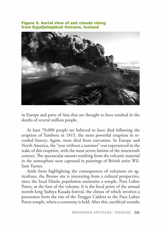
Figure 5. aerial view of ash clouds rising from eyjafjallajökull Volcano, iceland

GE225
and bundles are thrown into Mount Bromo. Most of the sacrificial goods are retrieved by poor people from the local Muslim commu-nity waiting inside the crater.
Most people don’t live in the vicinity of volcanoes. However, volcanoes may exert their influence over great distances. The rela-tively recent eruption of Eyjafjallajökull volcano (figure 5) is a good example of this. While the eruption did not cause a single fatal-ity (with only moderate damage in surrounding areas), the volcano, combined with risk-averse politicians, was responsible for an un-precedented disruption to air traffic in Europe. Millions of travelers were grounded, and airlines sustained heavy financial losses.
In high concentrations, volcanic ash can abrade aircraft surfaces. Furthermore, the high temperatures in modern jet engines can melt the ash and cause it to accumulate inside, ultimately leading to en-gine failure. This was demonstrated in 1982, when a British Airways Boeing 747 unwittingly flew into an ash cloud emitted from Mount Galunggung volcano at night, resulting in temporary failure of all four engines and severe sandblasting of the cockpit window and all leading edges. Fortunately, the engines could be restarted in time to perform an emergency landing at Jakarta. The incident played a significant role in the establishment of volcanic ash warning systems for aviation.
Ash concentrations over Europe during the Eyjafjallajökull erup-tion were, however, not comparable to the dense ash cloud encoun-tered by the British Airways flight, and no problems were noted during test flights with commercial airliners in the closed airspace.
The image above was taken from a small aircraft during a brief flight over the crater several weeks after the onset of the eruption.
Plymouth, Montserrat’s capital city, was built at the foot of Soufriere Hills volcano. The island was small and entirely volcanic in origin, but with no memory of volcanic activity for hundreds of years, it seemed like a suitable place to establish a settlement. How-ever, in 1995 the volcano started to erupt and has been active up to the present day. Phases of increased activity have been interspersed with phases of little or no visible activity.

ReSeaRCh aRtiCleS / RoSCoe 226
The initial eruptions caused no fatalities in Plymouth. Based on scientific advice, from April 1996 onwards the town was evacuated several times before a more permanent exclusion zone encompass-ing the town was established, effectively leading to abandonment of the site. Living in the shadow of such a volcano was considered a totally unacceptable and unmanageable risk by local government. Since then, the abandoned town has been gradually buried by lahars (mudflows), when material deposited on the slopes of the volcano is washed down during episodes of heavy rainfall. The partially buried courthouse, shown in figure 6, was originally two stories high. It is now completely buried.
Abandonment of the island’s capital meant that 80 percent of the island’s population had to relocate. The rapidly constructed shelters were cramped and the population was suffering economic hardship. Many of the areas encompassed by the exclusion zone had not been affected by the volcano, so many people were unofficially spending
Figure 6. Plymouth Court house buried in lahar deposits, Montserrat

GE227
time in their homes or working their land in spite of the danger. The fact that nobody had been killed by the volcano in living memory also tempered people’s fears. In June 1997, 19 people were killed when unexpectedly large pyroclastic flows spilled out of a valley and inundated farming settlements north of the volcano.
Since this event, enforcement of the exclusion zone has become stricter, causing conflict between local authorities and inhabitants, and also between local authorities and the photographers seeking to document the volcano.