volcano heights sector development plan • iineighborhoodplanning.org/pdf/vhsdp part3.pdf · tered...
TRANSCRIPT

IILand Use
Plans and Policies (See Appendix 1 in the Volcano Heights Planning Study Report
for a more detailed review of existing policies).
The following land use plans and policies govern development in the Plan Area
Rank 1 Albuquerque-Bernalillo County Comprehensive Plan (CP)Albuquerque Planned Growth Strategy (PGS)
Rank 2 West Side Strategic Plan (WSSP)
Rank 3 Northwest Mesa Escarpment Plan (NWMEP)
Other Prior to the adoption of the VHSDP, Executive Communication (EC-35) set policy for water service connections. EC-35 has beensuperceded by the VHSDP.
Applicable policies can be summarized as follows:
• New development may occur where vacant land is contiguous to existing orprogrammed urban facilities (CP)
• Service extensions for areas with multiple ownership and premature plattingonly when there is reassembly or sector plans provided (CP)
• Open space lands and water shall be acquired or regulated as appropriate toserve one or more of the following purposes: conservation of naturalresources and environmental features; opportunities for outdoor educationand recreation; shaping of the urban form; conservation of archeologicalresources; provision of trail corridors (CP)
• Criteria for designation of new activity centers that include transit servicepotential, fiscal impact, capacity of public services, market potential, poten-tial for shaping the built environment (CP, WSSP)
• Design controls to protect the escarpment, archeological and other resourcesthrough controls on height, runoff, color and materials (NWMEP)
• Preservation of views to and from the volcanic escarpment through setback,height and building massing limits (WSSP)
• In the Volcano Cliffs area, the City shall encourage assembly of lots of mul-tiple owners, cluster housing to provide more open space and efficient provi-sion of utilities, use of xeriscape landscaping and other water conservationtechniques; to be encouraged through provision of master plan infrastructureprior to normal extension of infrastructure in Priority 2 areas when cost ofinfrastructure is exceptionally low to the City and in a way that avoids scat-tered site development in adjoining areas (WSSP)
Volcano Heights Sector Development Plan • 25
Land Use Plans and Policies
• Orderly, efficient (from the standpoint of urban infrastructure), and environ-mentally sensitive development of the Volcano Cliffs are through planningapprovals and infrastructure extension determinations (WSSP)
• Under EC-35, criteria for provision of water service include minimum of100 acres assembly, adequate street network, 30% (not private) commonopen space, clustering of housing, xeriscape and water conservation as deter-mined by the City Council (EC-35). The VHSDP incorporates some ofthese criteria and supercedes EC-35.
Volcano Heights Sector Development Plan • 26
Land Use Plans and Policies
IIIPlanning Process
1. COORDINATION WITH LAND OWNERS AND AGENCIES
The Planning Management Team included the City Council Office and the PlanningDepartment. The Planning Team consisted of land use, architectural, urban design,open space, legal, transportation and planning consultants.
The Planning Team gathered extensive information on plans for public infrastructure,including drainage, water and transportation systems, and on land use plans and poli-cies. The team held interviews with the Albuquerque Metropolitan Area Flood ControlAuthority (AMAFCA), Albuquerque Public Schools, the City-County Water Authority,the Mid Region Council of Governments (MRCOG), economic development agencies,and City Transportation, Planning, Parks and Recreation, and Transit departments andheld a series of coordination sessions in September 2005. In addition, an interview washeld with Rio Rancho officials regarding the redevelopment and land assembly processthat Rio Rancho has used to facilitate development in areas of obsolete plats. (SeeAppendix 2 of the Volcano Heights Planning Study Report)
Interviews with the National Park Service, City Open Space staff, and State officials pro-vided information on the Petroglyph National Monument and other open space needs.The team interviewed experts knowledgeable regarding the area’s archeology, anthropol-ogy and Hispanic and Native American history to understand the cultural backgroundof the area.
Private Development PlansIn September and October of 2004, the meetings and interviews with City and Countyplanning staff, developers, and property owners yielded information on the current sta-tus of development plans. Discussions with the developers of Vista Vieja subdivisionoccurred throughout the planning process, resulting in adjustments to their master planthat added a hiking and bicycle trail, a central plaza, other “walk-to” amenities, andgreater variety of housing types. Similarly the team met with representatives of LongfordHomes and La Cuentista subdivisions and held interviews with representatives of SAD227 and the Volcano Cliffs Property Owners Association.
2. LAND USE SCENARIOS
Based on analysis of information gained through interviews, agency meetings, and col-lection of materials, in December of 2004 the team prepared three scenarios thatexplored different ways to develop. (See Exhibit 16, Comparisons of InitialScenarios)
Volcano Heights Sector Development Plan • 27
Planning Process

Volcano Heights Sector Development Plan • 28
Planning Process
Exhibit 16Comparisons of Initial Scenarios
January, 2005

1. Trend. This scenario assumed extension of current development patterns under pres-ent zoning to the undeveloped portions of the Plan Area. It illustrated projects that arein advanced and initial phases of development, along with application of similar subur-ban densities elsewhere in the Plan Area. Lots under 1 acre in the Volcano Cliffs areawould remain as platted. Roughly 12,000 dwelling units and few jobs would resultunder this scenario.
2. Village. This scenario emphasized protection of open space and cultural resources.Residential areas were organized around walkable villages with modest retail services.Substantial areas would remain rural in character. Roughly 8,000 dwelling units andfew jobs would result under this scenario.
3. Town Center. This scenario introduced a pedestrian-oriented town center at thePaseo del Norte-Unser intersection. Approximately 5,000,000 square feet of commer-cial and office space and approximately 20,000 jobs were initially assumed for the TownCenter and Office Campus so that a mix of retail, entertainment and urban residentialuses can be placed near each other at a location with excellent regional access. This sce-nario assumed the same number of dwelling units as under Trend (12,000 DUs) butoffered more variety ranging from urban residential to rural estates. It organized devel-opment in a way that would allow adding critical land to the open space system.
3. COMMUNITY INVOLVEMENT PROCESS
1. Design WorkshopsThe community process consisted of twomajor design workshops. The first, held inJanuary 2005 and attended by over 150people, provided opportunity for propertyowners, developers, civic and communityparticipants to visualize how the area shoulddevelop.
After describing existing conditions, contextand trends, the planning team presented thethree alternative scenarios described abovefor consideration. Two days discussion andanalysis followed, in which participantsinteracted with the professional planningteam in small groups to analyze the pros andcons of the three scenarios. A modified ver-sion of the Town Center scenario was cho-sen as the preferred alternative. For moredetail on this workshop, see the Volcano Heights Planning Study Report, March 15, 2005.
A second all-day planning workshop was held on October 13, 2005. The purpose wasto inform community groups about the Volcano Heights draft Concept Plan and engagethem in developing more detailed pedestrian, bicycle, transit, vehicular and land usesolutions in a design session with the planning consultants. Groups participating includ-ed the Transportation Forum, North Valley Coalition, 1000 Friends, Sierra Club, APS,
Volcano Heights Sector Development Plan • 29
Planning Process
CharrettePresentation,January, 2005
and key agencies including City Transit Department, Municipal DevelopmentDepartment / Transportation, City Planning and MRCOG.
The workshop began with presentations on the planning framework including Centersand Corridors and Paseo del Norte (PdN) and Unser design requirements and accesspolicy. Constraints on the plan include current transportation, zoning and utility poli-cies and several development projects in the pipeline exempted from moratorium.Modifications to the population and land use assumptions of the Planned GrowthStrategy and Metropolitan Transportation Plan are needed as well. Given these con-straints, the plan for Volcano Heights presents an opportunity to create a sustainablegrowth pattern for this portion of the West Side.
Workshop participants discussed how the limited access policies for PdN and Unseraffect street type, land use and pedestrian / transit-oriented design. Participants thenbroke into groups and worked with the consultants to draw their proposals for intersec-tion treatment and transit and pedestrian connections. The Planning Team addressedthese proposals by further exploring design standards for the Paseo and Unser intersec-tion, analyzing a potential boulevard treatment, considering pedestrian / bicycle solu-tions across arterials, and modifying land use assumptions. The workshop led to a moredetailed engineering study of intersection design and detailed modeling of the ConceptPlan’s impact on the West Side transportation network. (See “Kimley-Horn Analysis”in 4.2 below)
2. Presentations and Website CommentsPlacement of the Volcano Heights Planning Study Report on the City’s website inMarch 2005 afforded a third means for the public and property owners to express theirconcerns. Comments were received through the [email protected] e-mail link.Most responses expressed a desire to be kept informed on the plan and its schedule.
Presentations on the plan were made to stakeholder and community groups includingthe North Valley Coalition, neighborhood associations, the Volcano Cliffs PropertyOwners Association (VHPOA), Bedrock Partners, and other major land owners.
3. Concerns and IssuesThe community involvement process afforded opportunities for the planning team tohear from a large turnout of Volcano Cliffs Property Owners Association (VCPOA),other area property owners, developers active in the area, and from community groups.The following concerns and issues emerged to be addressed by the plan.
Property owner and developer issues:
• Desire for rapid implementation of the plan after years of waiting for development approval. Many property owners believe that the City ofAlbuquerque made commitments to provide utilities at property ownerexpense as a result of 1981 annexation and platting.
• Opposition to the magnitude of open space proposed in the plan unlessopen space funding is identified. Suggested funding sources are generalfund, gross receipts tax, impact fees, or assessment with fair considerationof local versus citywide benefit.
Volcano Heights Sector Development Plan • 30
Planning Process

• Requests for market feasibility studies for employment, mixed use and retailrecommendations. Other employment opportunities at Double Eagle,Quail Ranch, Coors, Atrisco and Rio Rancho should be taken into consid-eration. Not all those who live in Volcano Heights will work there, andon-site employment should not be a condition of development.
• Development of Rural Estates with minimal city utilities for roads only,using shared water walls, environmentally friendly septic systems andallowance for minimum lot sizes under 10 acres.
• Concern that regulatory changes to zoning should not hold up the approvalprocess.
• Desire for agreement on phasing and sequencing schedule for development.
• Inter-agency agreements for joint use and co-location of schools, parks,recreation, libraries.
• Desire to move the process along in a cooperative and timely mannerthrough sector plans tied to Special Assessment Districts (SADs) and PublicImprovement Districts (PIDs) using existing platting with voluntary assem-blage.
Community issues:
• Transportation impacts and impacts of the Town Center scenario on trafficand bridge crossings emerged as a major concern in the second communityworkshop.
• Desire for additional open space for citywide view preservation and respectfor cultural and ecological preservation.
• Concern over exacerbating already existing infrastructure deficiencies onthe West Side resulting from development.
• Concern over capacity of the West Side transportation system to handleadditional development in this location and potential east-west trafficimpacts.
• Request for Transportation and Transit Study to assess impact of the planon regional system and land use relationships.
If these owner and community issues can be addressed, participants in the design work-shops supported creating a development character that is different than the rest ofAlbuquerque, that provides more choice in housing types, creates walkable communi-ties, and offers a connected network of open space and trails. By focusing on compre-hensive planning and quality design, participants saw that economic value, resourceconservation, and broad city-wide benefits can be realized simultaneously. Next stepsincluded development of design standards especially for town and village centers todefine appropriate building scale, heights, and building forms with new zoning cate-gories to accomplish the vision.
Volcano Heights Sector Development Plan • 31
Planning Process

4. TRANSPORTATION STUDIES
1. MRCOG Transportation ModelingThe Planning Team worked with the Mid Regional Council of Governments(MRCOG) to model the transportation impacts of the scenarios:
1) Baseline (screenline) that assumes no development in Volcano Heights butwhere approved projects in the surrounding area are built.
2) Trend scenario where single-family densities that average 4.5 dwellings pergross area continue to prevail through-out the area, except near the intersectionof Paseo del Norte and Unser whereBedrock Properties had retail and high-er-density housing under considerationprior to this planning effort.
3) Village scenario, where developmentonly occurs within the limits of existingwater system, effectively down-zoningland beyond this zone.
4) Town Center scenario that brings about18,000 new jobs to the West Side andplaces most jobs and housing within ashort walk of retail conveniences andtransit.
Additional analysis showed reduced travel(internalized) by land use scenario usingassumptions based on mixed use and urbandesign criteria. Because of its balance of com-plementary land uses, the Town Centermodel assumed that 25% of trips would notneed to leave the planning area or could beaccommodated on transit (an assumptiontypically made for well-considered mixed-useprojects and that can be enforced throughdevelopment standards.)
Summary of Conclusions (See “Appendix G.Kimley-Horn Memorandum” for additionalresults of transportation modeling)
Under the Baseline and Trend scenarios, sub-stantial residential developments of approxi-mately 100,000 planned additional popula-tion in the surrounding areas to the west andnorthwest result in Level of Service (LOS) F in the commute direction in many parts ofthe transportation system including river crossings. (See Exhibit 17, Volcano Cliffs2025 Trend Baseline Alternative PM Peak Hour Level of Service). Exhibit 18,
Volcano Heights Sector Development Plan • 32
Planning Process
Exhibit 17Volcano Cliffs 2025 Trend Baseline Alternative PM Peak Hour Level of Service
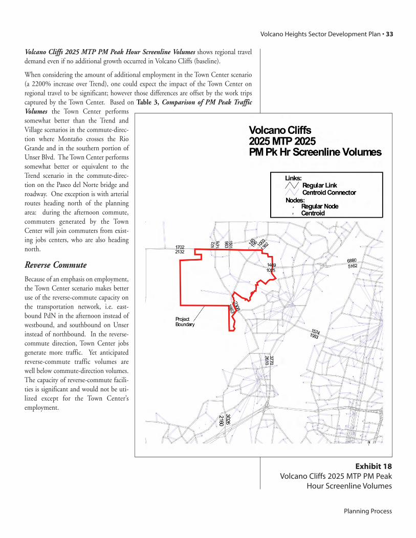
Volcano Cliffs 2025 MTP PM Peak Hour Screenline Volumes shows regional traveldemand even if no additional growth occurred in Volcano Cliffs (baseline).
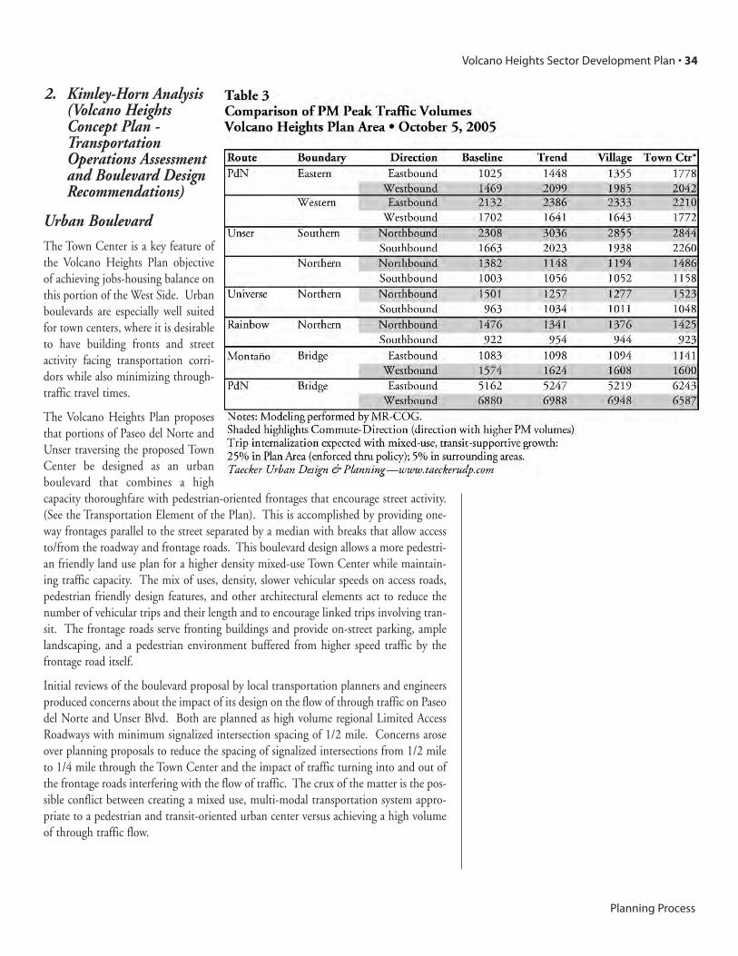
When considering the amount of additional employment in the Town Center scenario(a 2200% increase over Trend), one could expect the impact of the Town Center onregional travel to be significant; however those differences are offset by the work tripscaptured by the Town Center. Based on Table 3, Comparison of PM Peak TrafficVolumes the Town Center performssomewhat better than the Trend andVillage scenarios in the commute-direc-tion where Montaño crosses the RioGrande and in the southern portion ofUnser Blvd. The Town Center performssomewhat better or equivalent to theTrend scenario in the commute-direc-tion on the Paseo del Norte bridge androadway. One exception is with arterialroutes heading north of the planningarea: during the afternoon commute,commuters generated by the TownCenter will join commuters from exist-ing jobs centers, who are also headingnorth.
Reverse CommuteBecause of an emphasis on employment,the Town Center scenario makes betteruse of the reverse-commute capacity onthe transportation network, i.e. east-bound PdN in the afternoon instead ofwestbound, and southbound on Unserinstead of northbound. In the reverse-commute direction, Town Center jobsgenerate more traffic. Yet anticipatedreverse-commute traffic volumes arewell below commute-direction volumes.The capacity of reverse-commute facili-ties is significant and would not be uti-lized except for the Town Center’semployment.
Volcano Heights Sector Development Plan • 33
Planning Process
Exhibit 18Volcano Cliffs 2025 MTP PM Peak
Hour Screenline Volumes
2. Kimley-Horn Analysis (Volcano HeightsConcept Plan -TransportationOperations Assessmentand Boulevard DesignRecommendations)
Urban Boulevard The Town Center is a key feature ofthe Volcano Heights Plan objectiveof achieving jobs-housing balance onthis portion of the West Side. Urbanboulevards are especially well suitedfor town centers, where it is desirableto have building fronts and streetactivity facing transportation corri-dors while also minimizing through-traffic travel times.
The Volcano Heights Plan proposesthat portions of Paseo del Norte andUnser traversing the proposed TownCenter be designed as an urbanboulevard that combines a highcapacity thoroughfare with pedestrian-oriented frontages that encourage street activity.(See the Transportation Element of the Plan). This is accomplished by providing one-way frontages parallel to the street separated by a median with breaks that allow accessto/from the roadway and frontage roads. This boulevard design allows a more pedestri-an friendly land use plan for a higher density mixed-use Town Center while maintain-ing traffic capacity. The mix of uses, density, slower vehicular speeds on access roads,pedestrian friendly design features, and other architectural elements act to reduce thenumber of vehicular trips and their length and to encourage linked trips involving tran-sit. The frontage roads serve fronting buildings and provide on-street parking, amplelandscaping, and a pedestrian environment buffered from higher speed traffic by thefrontage road itself.
Initial reviews of the boulevard proposal by local transportation planners and engineersproduced concerns about the impact of its design on the flow of through traffic on Paseodel Norte and Unser Blvd. Both are planned as high volume regional Limited AccessRoadways with minimum signalized intersection spacing of 1/2 mile. Concerns aroseover planning proposals to reduce the spacing of signalized intersections from 1/2 mileto 1/4 mile through the Town Center and the impact of traffic turning into and out ofthe frontage roads interfering with the flow of traffic. The crux of the matter is the pos-sible conflict between creating a mixed use, multi-modal transportation system appro-priate to a pedestrian and transit-oriented urban center versus achieving a high volumeof through traffic flow.
Volcano Heights Sector Development Plan • 34
Planning Process

No local standard presently exists for urban boulevards, where arterial through-traffic isaccommodated in center lanes, and local traffic and site access is accommodated onaccess lanes or frontage roads. The Planning Team asked that the traffic flow throughthe Town Center be modeled by a professional engineer to determine the impact of theproposed boulevard design on traffic movement and to provide design assistance espe-cially for this portion of the roadway network. Kimley-Horn and Associates, a nation-al transportation planning and engineering firm, provided the needed analysis.
The Kimley-Horn study compared the “Base Plan” intended to speed traffic through thearea with the “Concept Plan” that contained several elements to address traffic flowthrough a balance of land use, transit, and roadway design. Transportation modelingwas used to compare the traffic handling performance of the two alternative approach-es. The model analyzed congestion levels at fourteen intersections in the VolcanoHeights Plan area as a whole, at Paseo del Norte and Unser travel times eastbound andwestbound, distance traveled, average speed, and level of service.
Intersection Spacing The Kimley-Horn analysis concluded that more frequent intersection spacing might beaccommodated in a few limited locations with a negligible increase in travel times whenmoving through the planning area. Quarter-mile spacing for right-in / right out inter-sections could also be accommodated with a negligible increase in travel times. Kimley-
Horn reports: “The difference in total corridor travel time between the two scenarios isless than 60 seconds. This can be considered a negligible difference concluding that theConcept Plan does not significantly degrade level of service.” In short, the many bene-fits of the Town Center can be achieved without materially reducing traffic flow.
Reviewers also raised concerns for the safety of merging traffic between the access roadunder the boulevard configuration and through traffic. Kimley-Horn modeled trafficflow at these access points and provided a conceptual design of the Paseo del NorteBoulevard which incorporated safety features that address the issue. Figure 2,Conceptual Design of Paseo del Norte Blvd. shown above is from the Kimley-HornMemorandum.
Volcano Heights Sector Development Plan • 35
Planning Process
Figure 2Conceptual Design ofPaseo del Norte Blvd.

UnserIn 1989 the Albuquerque City Council established alignment and design standards forUnser, stipulating that Unser be a parkway with not more than four travel lanes. Theanalysis shows that six travel lanes will be needed on Unser south of its intersection withPaseo del Norte, to reduce traffic congestion partly attributable to afternoon commut-ing from jobs toward the southeast to homes west and north of Volcano Heights.
The Kimley-Horn Memorandum (Volcano Heights Concept Plan—Traffic OperationsAssessment and Boulevard Design Recommendations) includes roadway configurationand traffic levels throughout the Volcano Heights road system, and design recommen-dations for key portions of Paseo del Norte and Unser. The design recommendationshave been incorporated into the Volcano Heights Plan.
5. VIEW ANALYSIS
The volcanoes, rising above the volcanic escarpment on the western horizon ofAlbuquerque, form a dramatic backdrop to the city on the west, as the SandiaMountains do to the east. They are an important part of Albuquerque’s identity and aprominent natural feature framing the city. As described in the Meaning of Place sec-tion, for Native Americans, spiritual contemplation often embraced views to theVolcanoes, the Sandia Mountains and the Rio Grande, views that are appreciated by allcultures.
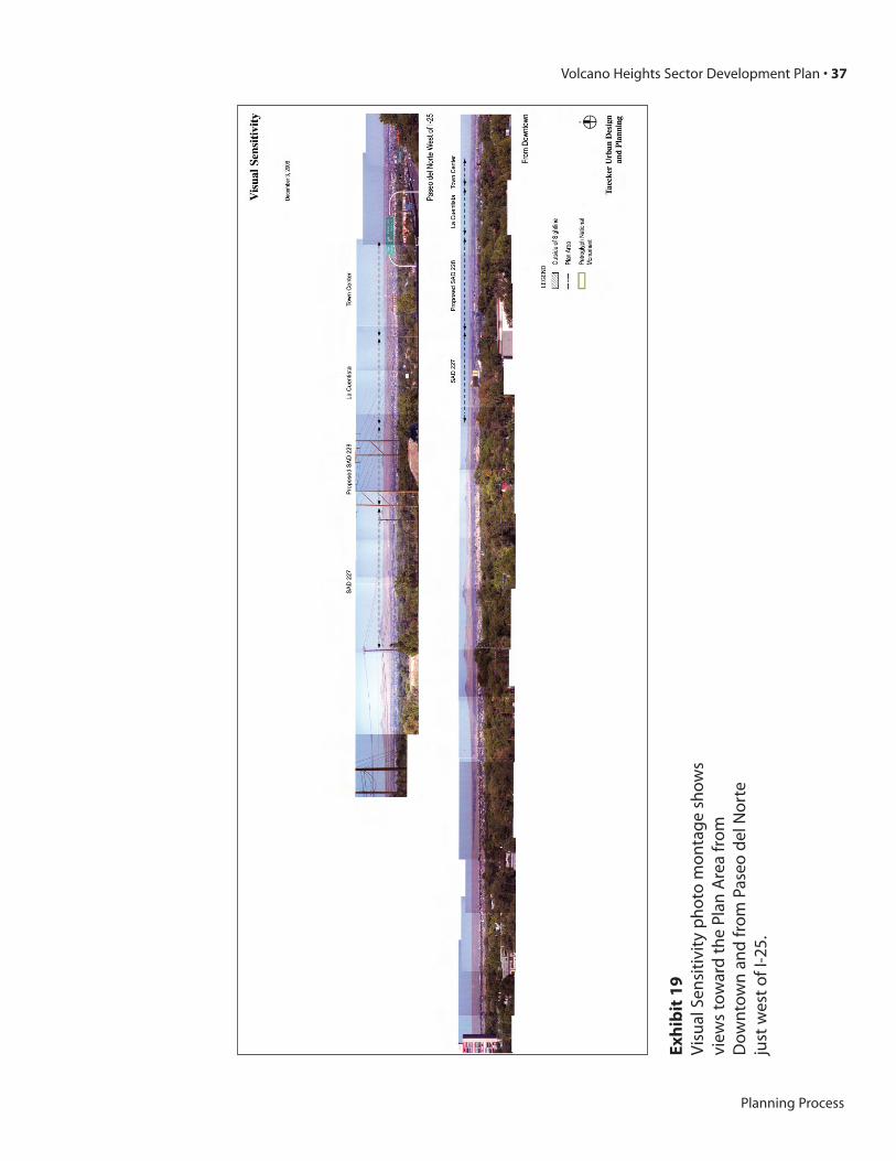
Development of the Volcano Heights Plan Area will impact views that residents seelooking toward the western edge from the rest of the city. The Visual Sensitivity photomontage shows views toward the Plan Area from Downtown and from Paseo del Nortejust west of I-25. (See Exhibit 19, Visual Sensitivity) It provides visual information onthe extent to which different Plan Areas will be seen and where the new developmentwill be located on the city’s western horizon. From these distant locations the top of theescarpment is visible no matter how low the buildings are. The arrows indicate theapproximate ranges of the land use districts.
Further analysis was done showing cross sections from Golf Course Road to the escarp-ment and from the Montaño and Unser intersection northward. The additional openspace setback that the Plan calls for along the Escarpment appears to be sufficient tokeep development from being seen from these points. An exception is the SuburbanResidential area east of the Town Center and north of Paseo del Norte. Golf Course rep-resents a point east before descending into the alluvial basin of the Rio Grande; VolcanoHeights is not visible from any point along Coors, the western edge of the basin.
Views to the volcanoes and the geologic windows from within the Plan Area will be pro-tected per guidelines in the “Urban Design” section.
Design standards for color and reflectivity will help to mitigate the impact of develop-ment visible from distant locations.
(Note: Additional viewshed analysis was performed under build-out conditions. See “V. Architecture and Landscape Design, 2. View Shed Findings”.)
Volcano Heights Sector Development Plan • 36
Planning Process
Volcano Heights Sector Development Plan • 37
Planning Process
Exh
ibit
19
Vis
ual
Sen
siti
vity
ph
oto
mo
nta
ge
sho
ws
view
sto
war
dth
ePl
anA
rea
fro
mD
ow
nto
wn
and
fro
mPa
seo
del
No
rte
just
wes
to
fI-2
5.

Section TwoPlan Elements

IFundamental
Goals
NEIGHBORHOODS
Recognize walkable neighborhoods and districts as essential building blocks of amore sustainable city and region.
Strong and healthy neighborhoods, because they operate at a scale where people walkand interact, are essential to successful and sustainable urbanization. Organizing devel-opment within walkable mixed-use districts and neighborhoods supports transit, econ-omizes on infrastructure, and respects the environment.
Bring homes, businesses and daily destinations—like retail and community facili-ties—closer together within neighborhoods and districts.
Most homes should be within walking distance of a mixed-use village center containingretail, community services, and a small park or plaza. Studies have shown that this walk-able pattern of development can reduce the number of vehicle-trips dramatically.Walkable districts and neighborhoods also have proven social and economic benefitsresulting from better access to basic needs, amenities, safer and more active streets,improved health through physical activity, and greater cultural cohesion.
Distribute schools and parks throughout Volcano Heights, in accessible locationswhere children will not have to cross a busy street to get to them. Schools shouldnot be isolated from but instead located in village centers or linked to the trailnetwork and co-located with parks.
These locations create a rich learning environment for children to experience commu-nity life and nature. When schools and parks are closer to home, parents can spendmore time with their children, older children can enjoy greater independence, and per-sonal health and fitness improves. Co-locating schools and parks makes better use oflimited public dollars and provides more developable land. Locating schools near vil-lage centers integrates schools into the neighborhood and fosters a sense of community.
Develop schools that are welcoming community facilities providing multiple usesfor residents of all ages.
Schools should be integrated into the communities through their physical design andlocation, the programs offered, and policies concerning access. Recreational, civic,human service, and educational programs should be provided there to all members ofthe community at extended hours after school, on the weekends, and during the sum-mer.
Volcano Heights Sector Development Plan • 39
Fundamental Goals

Promote diverse housing options throughout Volcano Heights.
A variety of housing types—at varying densities—allows residents, if they choose to doso, to move through all stages of life within the same neighborhood. Housing diversitywill also promote business attraction and balanced development on the West Side.
TRANSPORTATION
Provide a choice of viable transportation options for commuting and daily needs.
Walking is a liberating travel option, especially for children and the elderly. At greaterdistances, transit should offer a convenient alternative to Single Occupancy Vehicles(SOV). Reducing reliance on the automobile reduces congestion and pressures to widenroads and bridges, especially at regional “pinch points” like the Rio Grande.
Support an efficient and reliable transit system.
To support frequent service with less public subsidy, transit corridors should be linedwith higher densities and major retail, commercial, and employment destinations. Insuburban settings, Bus Rapid Transit (BRT) presents a cost-effective alternative withtravel times that compete with door-to-door car use and paves the way for potentialfuture light rail routes. Exclusive transit (and HOV) lanes are incorporated into Paseodel Norte and Unser in order for transit to draw closer to the performance of SOV, espe-cially important to attract middle class commuters.
Create “Great Streets” for people as well as cars, by providing street trees, land-scaping, wide sidewalks and active uses.
Paseo del Norte and Unser will adopt boulevard configurations through the TownCenter to help secure these desirable activities. Streets should feel safe and comfortablefor pedestrians. The design of streets and the buildings that face them influenceswhether someone will chose to walk. Pedestrian-friendly streets have wide sidewalks,street trees and slow moving traffic. They also have pedestrian scaled buildings with fre-quent entries, windows, and attractive features. Parking lots and blank walls should beminimized along pedestrian routes.
Connect different uses and areas by an efficient and convenient street network.
Streets should not create barriers that separate people and neighborhoods. Instead,streets should create safe and direct connections between common destinations. Streetsshould also be designed to control auto speeds and be a comfortable place for neighborsto come together. Rather than concentrate traffic, street will distribute traffic throughgreater connectivity of roadways.
EMPLOYMENT
Support the creation of a major jobs center in Volcano Heights.
Most working West Side residents commute to work east of the Rio Grande (many indowntown Albuquerque or along Interstate 25), which explains regional traffic conges-tion at river crossings and on the West Side. Major job growth in Volcano Heights willprovide opportunities for working closer to home and will “reverse” commutes in adirection where roads have existing capacity. Frequent and reliable transit service will beprovided for these new workers.
Volcano Heights Sector Development Plan • 40
Fundamental Goals

Establish a mixed-use town center as a transit-oriented development that offers arange of retail, commercial and entertainment destinations, urban housing andemployment opportunities.
While neighborhood retail can meet most daily requirements, many needs must be metwithin larger centers that receive the patronage of greater populations. A mixed-useTown Center will bring to Volcano Heights and the West Side opportunities for com-parison-shopping, entertainment, restaurants, cultural activities, and government serv-ices. Following the West Side Strategic Plan, a well-designed central plaza will serve asa focus for community life in the Town Center and create a sense of place. Many peo-ple prefer dense urban housing in mixed-use environments, which greatly increase thelikelihood of walking and transit use. Transit, amenities and housing in the TownCenter will help to attract employment to the West Side.
OPEN SPACE AND TRAILS
Establish an interconnected open space network comprised of parks, arroyos, thePetroglyph National Monument, and other open spaces.
While development in Volcano Heights equals the loss of open space that many citizenshave enjoyed, it is also an opportunity to purchase and conserve open space into perpe-tuity. An organized system of open space can help conserve the natural environment,mitigate the impacts of development, and provide exceptional recreational opportuni-ties. Opportunities to experience nature should be plentiful, especially for children.Often, these open space features can form the boundary of neighborhoods and main-tain distant views to the Volcanos and Sandia Mountains.
Drainage channels have played an important cultural role for prehistoric communities,connecting ceremonial sites on the mesa across the escarpment to Pueblo villages alongthe Rio Grande. They can be used today to form an interconnected east-west trail sys-tem along these original pathways.
Conserve Volcano Heights’ arroyos and encourage residents’ connections withnature.
The area’s arroyos contain valuable habitat and scenic features that are distinctive. Thearroyos contain many unique animals and plants, many used for medicinal and ceremo-nial purposes by Native American and Hispanic people, which could be threatened bydevelopment and a dramatic increase stormwater run-off that accompanies it. As lin-ear open spaces, the arroyos and open space along Petroglyph National Monument alsooffer unique opportunities for trails.
Respect Albuquerque’s patrimony of culture and history, both Hispanic and NativeAmerican, through the development of Volcano Heights.
Volcano Heights provides a unique portal to understand the rich interplay of culturesthat is New Mexico. The “story” (actually stories) of the meaning of this place to NativeAmerican can be told through living and visiting in Volcano Heights, and by the waywe develop this special area. As such, Volcano Heights can be another entry point forall of Albuquerque into different and important perspectives on humans’ place on earthand spiritual path.
Volcano Heights Sector Development Plan • 41
Fundamental Goals

Preserve the Volcano Height natural environment through ConservationDevelopment.
In lower density residential areas, establish a form of Albuquerque subdivision thatreduces the development’s impact on the natural environment and integrates resourceconservation into the fabric of the community.
VIEWS AND CULTURAL RESOURCES
Conserve Volcano Heights’ archeological resources and protect and emphasize views and visual connections to the Volcanos, Sandia Mountains and the Rio Grande.
The Volcanoes, Petroglyph National Monument, outcrops of basalt especially contain-ing petroglyphs, the Sandia Mountains, and other locations are sacred places for manyNative Americans which still figure into their ceremonial practices. The NativeAmericans have left petroglyphs, evidence of prehistoric settlement, and other artifactswith still active religious and cultural value. Spiritual contemplation often embracedviews to the Volcanoes, the Sandia Mountains and the Rio Grande, views that areappreciated by all cultures. Views can be protected and enhanced through consideratesite planning, by creating view corridors using streets and arroyos, and by emphasizinglower scale development along the view corridors.
Maintain scenic edges for Albuquerque, protect important views, and minimizethe visual impact of development on the western horizon as seen throughout the city.
The westernmost portions of the Plan area, adjacent to the rising mass of the volcaniccones, will be conserved as open space with residential homes that are clustered ormaintained at rural densities. In addition, height, color and other visual qualities willbe controlled along the “front edge” of Volcano Heights—just above the escarpment andthroughout lower density residential areas. The built environment and landscape alongthe edge of Volcano Heights and the Petroglyph National Monument will form a pleas-ant transition from the natural area to the developed area. As seen from within VolcanoHeights, open space constitutes an important resource that demands special landscapeand architectural treatments.
Encourage practices that are economically, aesthetically and environmentally sound
Electrical utility distribution lines should be placed underground. Infrastructureimprovements should promote and make visible an environmental ethic for the area.
Encourage architectural and landscape treatments that are consistent with theregion’s traditions and climate, and help to establish a unique sense of place.
Albuquerque’s design traditions spring from its arid climate, intense sun, local materialsand the cultural background of its inhabitants. These considerations deserve continuedattention, out of respect for the past and also out of concern for an energy- and water-efficient future.
Volcano Heights Sector Development Plan • 42
Fundamental Goals
DEVELOPMENT PHASING
Provide for the orderly expansion of infrastructure and public facilities in the area
Volcano Heights’ infrastructure improvements will need to be phased in a way that rec-ognizes technical limitations and available funding and that provide infrastructure andfacilities in a timely way to meet the needs of residents and local employees. Elementaryschool boundary areas are used as the organizing principle for the timing and phasingof growth.
Volcano Heights Sector Development Plan • 43
Fundamental Goals