vulcan series addendum - b&g€¦ · ulc series • | 1 *988-11529-001* this addendum documents...
TRANSCRIPT

ADDENDUM Vulcan Series• sw release 2.0
| 1
*988
-115
29-0
01*
This addendum documents new features that are included in Vulcan Series software release 2.0 and that are not described in the Vulcan Series Operator manual or other documentation.
Feature Page
Software upgrades 3
• Network analyzer and service assistant 3
• Update software 3
• Backing up your system data 4
Navionics charts 5
• Dock-to-dock Autorouting 5
• SonarChart Live 5
• New SonarChart Live tide correction option 6
• View menu option changes 7
PredictWind weather routing and departure planner 7
• Requirements 8
• Set up and usage 8
• PredictWind Routing dialog options 10
• Download Management 11
• PredictWind routing summary 12

2 ADDENDUM | Vulcan Series

Software upgradesThe latest software is available for download from our website,www.bandg.com.
Before initiating an update to the unit itself, be sure to back up anypotentially valuable user data. Refer to "Backing up your system data" onpage 4.
The system or the Network analyzer and service assistant can advisesoftware updates are available.
Network analyzer and service assistantThe system has a built-in service assistant that creates a report ofthe devices installed on the NMEA 2000 network such as thesoftware versions, serial numbers, and information from the settingsfile to assist in technical support enquiries.
To use the analyzer, open the About page of the System settingsdialog and select Support. Two options are displayed:
Create reportAnalyzes your network and prompts you for information requiredfor support and creates the report with information automaticallygathered from the network. You can add screenshots and log filesthat will be attached to the report. There is a 20MB limit for thereport attachments. You can save the report to a memory card andemail it to support or upload it directly if you have an internetconnection. If you call technical support first, you can enter anIncident number to assist with tracking.
Check system for updatesAnalyzes your network and checks if updates are available forcompatible devices.
Ú Note: Connect your unit to the internet to check for the latestavailable software versions. The software versions will be up todate as of the last time you updated your unit or connected tothe internet.
Update software
Ú Note: Remove any mapping cards from your unit and install amemory card with sufficient storage before downloading
ADDENDUM | Vulcan Series 3
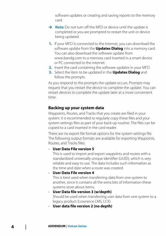
software updates or creating and saving reports to the memorycard.
Ú Note: Do not turn off the MFD or device until the update iscompleted or you are prompted to restart the unit or devicebeing updated.
1. If your MFD is connected to the Internet, you can download thesoftware update from the Updates Dialog into a memory card.You can also download the software update fromwww.bandg.com to a memory card inserted in a smart deviceor PC connected to the internet.
2. Insert the card containing the software updates in your MFD.3. Select the item to be updated in the Updates Dialog and
follow the prompts.
As you respond to the prompts the update occurs. Prompts mayrequest that you restart the device to complete the update. You canrestart devices to complete the update later at a more convenienttime.
Backing up your system dataWaypoints, Routes, and Tracks that you create are filed in yoursystem. It is recommended to regularly copy these files and yoursystem settings files as part of your back-up routine. The files can becopied to a card inserted in the card reader.
There are no export file format options for the system settings file.The following output formats are available for exporting Waypoints,Routes, and Tracks files:
• User Data File version 5This is used to import and export waypoints and routes with astandardized universally unique identifier (UUID), which is veryreliable and easy to use. The data includes such information asthe time and date when a route was created.
• User Data File version 4This is best used when transferring data from one system toanother, since it contains all the extra bits of information thesesystems store about items.
• User Data file version 3 (w/depth)Should be used when transferring user data from one system to alegacy product (Lowrance LMS, LCX)
• User data file version 2 (no depth)
4 ADDENDUM | Vulcan Series

Can be used when transferring user data from one system to alegacy product (Lowrance LMS, LCX)
• GPX (GPS Exchange, no depth)This is the format most used on the web that shares among mostGPS systems in the world. Use this format if you are taking data toa competitor's unit.
• Northstar.dat (no Tracks)Used to transfer data to a legacy Northstar device.
Navionics chartsSome Navionics features require the most current data fromNavionics. For those features, a message is displayed stating that thefeature is unavailable if you do not have the appropriate Navionicscharts or chart card inserted. For more information on what isrequired for these features, refer to www.navionics.com
Dock-to-dock AutoroutingThe Navionics’ Autorouting option is changed to Dock-to-dockAutorouting.
You use Dock-to-dock Autorouting in the same manner as youuseded Autorouting. For more information, refer to the operatormanual. In addition, Quick Info is supported.
Ú Note: Units designed for sale in the U.S. region do not haveDock-to-dock Autorouting capabilities. Dock-to-dockAutorouting features are disabled on all non-U.S. units whenthey are used in U.S. territorial waters.
Quick InfoWarning symbols are shown on route legs to identify possibledangerous items (for example, ‘Shallow water’). Select the warningsymbol to view the quick info pop-up which will tell you what thepossible danger is.
SonarChart LiveSonarChart Live is a real-time feature where the device creates anoverlay of depth contours based on your own live sonar soundings.
In the Navionics chart menu, select Overlay and then SonarChartLive to display it as an overlay on the chart.
ADDENDUM | Vulcan Series 5

When you select SonarChart Live overlay the menu expands todisplay SonarChart Live Options. Use the options to set thetransparency and minimum depth.
TransparencyThe SonarChart Live overlay is drawn on top of other chart data. Thechart data is completely covered at minimum transparency. Adjustthe transparency to allow the chart details to be seen.
Minimum depthAdjusts what SonarChart Live rendering treats as the safety depth.This affects the coloring of the SonarChart Live area. As the vesselapproaches the safety depth, the SonarChart Live area will graduallychange from a simple grey/white to red.
New SonarChart Live tide correction optionThe new SonarChart Live tide correction option is added to theChart Settings dialog.
SonarChart Live tide correctionWhen selected, the tide correction feature uses information fromnearby tide stations (if available) to adjust the depth values used bySonarChart Live as the sonar is recorded.
6 ADDENDUM | Vulcan Series

View menu option changesThe Navionics’ feature Fish N' Chip is renamed to SonarChart.
The SC Density menu option is new for SonarChart Live.
The Depth range highlight menu option is renamed to Fishingrange.
SonarChartThe system supports the Navionics SonarChart feature.
SonarChart displays a bathymetry map showing high resolutioncontour detail and standard navigational data. For moreinformation, refer to www.navionics.com.
SC DensityControls the density of the SonarChart and SonarChart Livecontours.
Fishing rangeSelect a range of depths between which Navionics fills with adifferent color.
This allows you to highlight a specific range of depths for fishingpurposes. The range is only as accurate as the underlying chart data,meaning that if the chart only contains 5 meter intervals for contourlines, the shading is rounded to the nearest available contour line.
No Depth highlight range Depth highlight range: 6 m - 12 m
PredictWind weather routing anddeparture plannerPredictWind Weather routing is an online weather routing servicefor creating the fastest or safest route for your trip based on weatherconditions.
ADDENDUM | Vulcan Series 7

The departure planner is an online service that advises the best dayto depart on a coastal or offshore trip. It summarizes the windconditions you will encounter the next 4 days of departure.
PredictWind routing can also provide a weather forecast for yourdestination. This information is available in the Summary panel.
Requirements• Internet connection – the unit must have an internet connection• Appropriate PredictWind subscription/account, refer to
www.predictwind.com.• PredictWind login credentials entered in the PredictWind settings
dialog.• Your boat performance details are entered in the polar table at
www.predictwind.com. Polars define the performance of yourboat in different wind and wave conditions. It is important todefine this accurately, so the optimal route is as accurate aspossible.
Set up and usage1. Connect your unit to the internet.2. Enter your PredictWind credentials in the PredictWind settings
dialog.
3. Launch the PredictWind routing feature, the following optionsare available:
8 ADDENDUM | Vulcan Series

• Route to cursor
a. Activate the cursor on the chart.
b. Select the PredictWind menu option.
c. Select Route to cursor to specify route to cursor information. For specifying details refer to "PredictWind Routing dialog options" on page 10.
d. Select Download to request a new route from PredictWind.
• Route to coordinate
a. Select the PredictWind menu option.
b. Select Route to coordinate to display the PredictWind Routing dialog.
c. Select the Destination option to set the destination coordinate and select OK. The PredictWind Routing dialog opens showing the destination coordinate you specified.
d. Select options in the PredictWind Routing dialog to specify route to coordinate information. For specifying details refer to "PredictWind Routing dialog options" on page 10.
e. Select Download to request a new route from PredictWind.
• Route to waypoint
a. Do one of the following:• Use the Find menu option, select Waypoints and then
select the waypoint in the list to open the Edit Waypoint dialog.
• Select Waypoints in the Tool panel dialog and select the waypoint in the list to open the Edit Waypoint dialog.
• Select the Waypoint on the chart. This lists the selected waypoint in the menu. Select the waypoint in the menu and then Details in the expanded menu to open the Edit Waypoint dialog.
b. Select PredictWind to specify route to waypoint information. For specifying details refer to "PredictWind Routing dialog options" on page 10.
c. Select Download to request a new route from PredictWind.
ADDENDUM | Vulcan Series 9

• Use existing route
a. Do one of the following:• Use the Find menu option and select the route in the list
to open the Edit Route dialog.• Select Routes in the Tool panel dialog and select the
route in the list to open the Edit Route dialog.• Select the Route on the chart. This lists the selected route
in the menu. Select the route in the menu and thenDetails in the expanded menu to open the Edit Routedialog.
b. Select PredictWind to specify routing information. Forspecfiying details refer to "PredictWind Routing dialog options" onpage 10.
c. Select Download to request a new route from PredictWind.
If there is an internet connection and proper account credentialsentered in the PredictWind settings dialog, a route will bedownloaded from PredictWind.
PredictWind Routing dialog options
Start TimeSpecify the start date and time. If Now is selected, the date and timeoptions are disabled.
Light Wind MotoringSpecify light wind motoring options:
10 ADDENDUM | Vulcan Series

• Motoring speed• The wind speed at which you would stop sailing and start
motoring
Polar Speed AdjustmentAdjust the polar speed by a percentage. If, for example, you aredelivering a boat short handed and expect the boat performance tobe slower than your Polar by 20%, apply 80% to the Polar SpeedAdjustment.
Routing Mode
You can select one of the following modes:
• Routing - Opens the PredictWind Routing dialog with RoutingOptions enabled. Select Routing Options to specify the windspeeds and swells you want to avoid on the route.
• Departure Planning - Opens the PredictWind Routing dialogwith Departure Options enabled. Select Departure Optionsto specify the time you want to space the departures and theforecast model (GFS/CMS or PWC/PWG) you want PredictWind touse.
• Destination Forecast - Select this option to request destinationforecast information from PredictWind.
Routing and destination forecast details are provided in theSummary panel.
Download ManagementTo view the status of any ongoing route downloads select the Filesicon on the Tool panel and then Transfers to see transfer status.When a download completes, the route is drawn on the chart. Oldroutes are deleted when the new route becomes available. If a route
ADDENDUM | Vulcan Series 11

is being followed when a new one is downloaded it will continue tobe followed until navigation is finished.
PredictWind routing summarySelect the Summary option in the PredictWind menu to viewdetailed routing information.
Additional summary information is available for wind, current, route, and swell.
Select Follow to sail the route.
12 ADDENDUM | Vulcan Series