wa 155 p (1) drilling ep summary - home » nopsema · the ep also covers proposed monitoring...
TRANSCRIPT

WA‐155‐P (1) Drilling EP Summary
1 05/05/2016 Re‐issued to NOPSEMA GS SM
0 13/04/16 Issued to NOPSEMA GS SM ‐
A 04/04/16 Issued for Review GS SM ‐
REV DATE DESCRIPTION BY CHK EM/PM

WA‐155‐P (1) Drilling EP Summary 2 of 92
CONTENTS
1. INTRODUCTION .................................................................................................................................. 4
1.1 Titleholders ...................................................................................................................................... 4
1.2 Compliance....................................................................................................................................... 4
1.3 Activity Duration and Timing ............................................................................................................ 4
1.4 Contact person ................................................................................................................................. 4
2. ACTIVITY LOCATION ........................................................................................................................... 5
2.1.1 Operational area .................................................................................................................................... 5
3. DESCRIPTION OF THE ACTIVITY ........................................................................................................... 7
3.1.1 Activities ................................................................................................................................................ 7
3.1.2 MODUs .................................................................................................................................................. 7
3.1.3 Exploration well. .................................................................................................................................... 7
3.1.4 Drilling Discharges ................................................................................................................................. 8
3.1.5 Well evaluation ...................................................................................................................................... 8
3.1.6 Support Vessels ..................................................................................................................................... 8
3.1.7 Helicopters ............................................................................................................................................ 9
3.1.8 ROV Operations ..................................................................................................................................... 9
3.1.9 Operational discharges .......................................................................................................................... 9
3.1.10 Fuel and Chemical Handling ................................................................................................................ 9
4. DESCRIPTION OF ENVIRONMENT ...................................................................................................... 10
4.1 Environment that May Be Affected (EMBA) .................................................................................... 10
4.1.1 Physical environment and habitats ..................................................................................................... 12
4.1.2 Habitats ............................................................................................................................................... 12
4.1.3 Commonwealth Marine Reserves, State Marine Parks and Marine Management Areas .................. 18
4.1.4 Muiron Islands Marine Management Area and Ningaloo Coast World Heritage Area (NCWHA) ...... 19
4.1.5 World Heritage Values and Management Principles .......................................................................... 19
4.1.6 Commonwealth Marine reserves ........................................................................................................ 20
4.1.7 State Marine Parks and Marine Management Areas .......................................................................... 27
4.1.8 Key Ecological Features within the EMBA ........................................................................................... 30
4.1.9 National Heritage Places ..................................................................................................................... 34
4.1.10 Hot Spots ........................................................................................................................................... 35
4.1.11 Marine Fauna .................................................................................................................................... 37
4.2 Socio‐economic Environment ......................................................................................................... 45
5. STAKEHOLDER CONSULTATION......................................................................................................... 52
5.1 Environment Plan Consultation ...................................................................................................... 53
5.2 Ongoing consultation ..................................................................................................................... 60

WA‐155‐P (1) Drilling EP Summary 3 of 92
5.3 Addressing ongoing consultation feedback ..................................................................................... 60
5.4 Summary ........................................................................................................................................ 61
6. ENVIRONMENTAL HAZARDS AND CONTROLS ................................................................................... 62
6.1 ALARP Evaluation ........................................................................................................................... 63
6.2 Acceptability Evaluation ................................................................................................................. 63
7. MANAGEMENT APPROACH .............................................................................................................. 89
8. HYDROCARBON SPILL RESPONSE ARRANGEMENTS........................................................................... 91
8.1 Net Environmental Benefit Analysis ................................................................................................ 95
8.2 Oil Spill Response Resources ........................................................................................................... 95
9. REFERENCES ..................................................................................................................................... 96

WA‐155‐P (1) Drilling EP Summary 4 of 92
1. INTRODUCTION
Quadrant Energy Australia Pty Ltd (Quadrant) is the registered operator for petroleum production Licence’s WA‐155‐P. Quadrant Energy proposes to drill a single hydrocarbon exploration well in Commonwealth petroleum permit WA‐155‐P(1). Subject to receipt of all government and business approvals, the Outtrim East‐1 well would be drilled between May to July 2016.
1.1 Titleholders
Quadrant Northwest Pty Ltd is the titleholder for petroleum activities covered under this EP within WA‐155‐P. For the purposes of this EP it will be referred to as Quadrant Energy.
Titleholder details are as follows:
Name: Quadrant Northwest Pty Ltd
(58 009 140 854 / 009 140 854)
Business address: Level 9, 100 St Georges Tce, Perth WA 6000
Telephone number: (08) 6218‐7494 (Fred Wehr)
Fax number: (08) 6218 7200
Email address: [email protected]
ACN: 009 140 854
1.2 Compliance
The overall purpose of the WA 155P (1) (EA‐00‐RI‐10077.01) Environment Plan (the EP) is to comply with statutory requirements of the Commonwealth Offshore Petroleum and Greenhouse Gas Storage (Environment) Regulations 2009 (OPGGS (E) Regulations) and to ensure that the Activity is planned and conducted in line with Quadrant environmental policies and standards, including the corporate Environmental Policy. The EP was assessed and accepted by the National Offshore Petroleum Safety and Environmental Management Authority (NOPSEMA) on the 31st March 2016. This EP summary has been prepared in accordance with the requirements of regulation 11 (4) of the OPGGS (E) Regulations.
1.3 Activity Duration and Timing
Based on stakeholder consultation feedback and known seasonal environmental sensitivities, Quadrant Energy will restrict the window for this activity from May to July in 2016. The duration for drilling the proposed well will be approximately 35 days. In the event that unplanned events occur it is also possible that the estimated number of days may be exceeded.
During the activity, operations will be 24 hours per day.
1.4 Contact person
Further information about the WA 155P (1) Activity can be obtained from:
Ashlee Crabbe
Consultation Coordinator
100 St Georges Terrace, Perth, 6000
6218 4972

WA‐155‐P (1) Drilling EP Summary 5 of 92
2. ACTIVITY LOCATION
The Activity is located within Commonwealth waters of the Carnarvon Basin in the North West Shelf region of Western Australia in petroleum permit WA‐155‐P(1). This EP provides for one exploration well being drilled in this permit only. The proposed well is the Outtrim East‐1 well (Error! Reference source not found.).
The surface hole location is indicative and may alter slightly as the well program is finalised (Table 2‐1). Outtrim East‐1 is approximately 41 km from the closest mainland coast at North West Cape Peninsula, 55 km from Exmouth and 68 km from Onslow (closest population centres).
Table 2‐1: Location of well
Well Outtrim East‐1
Permit WA‐155‐P(1)
Latitude 21° 31' 51.69" S
Longitude 114° 27' 41.60" E
Water Depth ~90 m
2.1.1 Operational area
The Operational Area for the EP is defined by the permit area WA‐155‐P(1) within which the MODU is connected or intended to be connected to the seabed. Activities described in this EP to be carried out within the Operational Area must comply with this EP. Activities outside the Operational Area will be managed in accordance with Commonwealth and State laws as required.
The southern boundary of Permit WA‐155(1)‐P has an adjoining state water boundary. Part of this boundary adjoins the Muiron Islands Marine Management Area.

WA‐155‐P (1) Drilling EP Summary 6 of 92
Figure 2‐1: Permit areas (Project Area) covered by this EP.

WA‐155‐P (1) Drilling EP Summary 7 of 92
3. DESCRIPTION OF THE ACTIVITY
3.1.1 Activities
This EP covers drilling, evaluating, and abandoning activities related to the Outtrim East‐1 exploration well, and can include any /all of the following:
Riserless drilling;
Installation of a blow‐out preventer (BOP);
Drilling using Water Based Muds (WBM);
Contingency using Loss Circulation Materials (LCM) as required;
Use of chemicals for drilling, evaluation and abandoning activities;
Installing and cementing casing strings;
Well evaluation including, wireline logging, hydrocarbon sampling and coring;
Plug and abandonment activities, including pulling casing strings and setting permanent cement barriers;
Side tracking and/or redrilling sections of the well;
MODU commissioning activities (e.g. equipment testing, tank flushing);
Temporary placement of equipment on the seabed;
Sidetrack drilling and re‐spud drilling (contingent and unplanned activities); and
Use of support vessels, helicopters, remotely operated vehicles (ROV) and autonomous underwater vehicles (AUV).
The EP also covers proposed monitoring activities, to collect data for drill cuttings model validation. The proposed monitoring activities, involving deployment of a subsea glider from a vessel, will commence approximately 10 to 14 days prior to the drill rig arriving at location, within May to July 2016.
Activities that are not covered in this EP include, but are not limited to, installation, production and decommissioning activities as well as vessel based seismic surveys.
3.1.2 MODUs
Drilling will be undertaken using a jack‐up which will remain at location (i.e. drilling site). Quadrant Energy proposes using the Noble Tom Prosser (the jack‐up currently contracted to Quadrant Energy). There will be no concurrent drilling activities within the permit area.
3.1.3 Exploration well.
The Outtrim East‐1 well design entails drilling surface and production1 intervals. The surface interval (or top hole) will be drilled ‘riserless’ using seawater with viscous sweeps utilising bentonite or a viscosifying polymer (i.e. xanthan gum) and a viscosified brine. Cuttings and well returns (e.g. sweeps) from the open hole will discharge directly into the seabed.
Cement will be used to form permanent barriers and fix casing strings in place. The first cement ‘job’ will be to fix the surface casing string (i.e. the casing string between the seabed and MODU) in place by pumping cement down the casing and forcing cement into the annular space between the casing and geological formation. The cement volume pumped is expected to remain downhole.
1 The naming convention used for the third drilling section (i.e. ‘production’) refers to the section at which the target reservoir will be encountered and not to the purpose of the drilling section or the Activity covered in this EP. This EP does not cover production activities that may follow drilling this well.

WA‐155‐P (1) Drilling EP Summary 8 of 92
Cement may also be used to seal a lost circulation zone, plug the well from which a side‐track may be drilled, or to suspend the well. Multiple cement plugs will also be set as permanent barriers when abandoning the well.
In the unlikely event of unrecoverable drilling complications while completing the surface interval, the well may need to be abandoned and re‐spudded. This would involve repeating the above process at a nearby location (nominally 50 metres from the original well location). The estimated time to re‐spud is approximately 2‐4 days.
The production interval will be drilled through the surface casing string, which creates a closed loop circulating system. After the surface blow‐out preventers (BOPs) have been installed, recirculating water‐based drilling fluids will be used to drill the remainder of the well, with well returns (i.e. the drilled solids or cuttings, and drilling fluids) circulated to the MODU for mechanical separation and treatment.
The water‐based drilling fluids (often referred to as water‐based mud, or WBM) are comprised of water or brine (>90% aqueous) as the major liquid phase. Apart from water or brine, WBM is made up of low toxicity drilling fluid additives (e.g. barite, calcium carbonate) that are either completely inert or additives in such low concentrations they pose little or no risk to the environment.
The well returns will be treated on‐board the MODU to separate the drilled solids and drilling fluids. Primary solids control will be achieved by the use of shale shakers. Centrifuges may also be used at times to remove ultra‐fine solids suspended in the recovered drilling fluids. Additional information on solids control equipment is provided below.
Separated drilled solids and unrecoverable drilling fluids will be discharged via a ‘dump chute hose’ to approximately 50 metres below the sea surface. The chute has been specifically installed for this well to ensure the potential for drilling discharge impacts is as low as reasonably practicable. The recovered drilling fluids will be pumped downhole or kept in surface storage tanks.
On well completion, recovered and reusable drilling fluids will be recycled to the next drilling program. If not reusable or recyclable on the next drilling program, drilling fluids will pumped down the dump chute hose for discharge below the sea surface.
3.1.4 Drilling Discharges
Drilling discharges account for:
Drill cuttings;
Drilling fluids and solids;
Brines; and
Cement (set or unset including Lost Circulation Material (LCM)).
3.1.5 Well evaluation
Well evaluation involves the collection of data on the well and surrounding formation. For this well, evaluation activities will include wireline logging and down hole geological coring.
Wireline logging is a continuous measurement of formation properties with electrically powered instruments using a sonde or logging tool that is lowered into the wellbore on a cable. Measurements can include electrical and sonic properties, active and passive nuclear measurements, dimensional measurements of the wellbore, formation fluid sampling, formation pressure measurement, and others..
3.1.6 Support Vessels
The MODU will be assisted by up to four support vessels that will transfer food, bulk drilling fluid materials, diesel and equipment used in the drilling process.
A support vessel standby mooring may be installed for the activity period.

WA‐155‐P (1) Drilling EP Summary 9 of 92
3.1.7 Helicopters
Helicopters will be used for crew changes and medivac, and occasionally equipment and material deliveries. Helicopter flights will occur several times a week dependent on the progress of the drilling program and logistical constraints.
3.1.8 ROV Operations
Remotely operated vehicle (ROV) surveys are likely to occur periodically. The ROV will be used primarily to conduct site condition surveys, monitor the jack‐up legs/spud cans, and to monitor drilling equipment and operations. The ROV may also be used to search for and recover a dropped object should an unplanned event occur.
3.1.9 Operational discharges
In addition to the drilling discharges (above), other operational waste streams from the MODU and support vessels are likely to include:
Deck drainage;
Putrescible waste and sewage;
Oily water;
Cooling water from operation of engines;
Desalination plant effluent (brine) and backwash water discharge; and
Ballast water.
3.1.10 Fuel and Chemical Handling
The main engines and equipment (e.g. pumps, cranes, winches, power packs, generators) used on MODUs, and support vessels require diesel for fuel, hydraulic fluid and lubricating oils for operation and maintenance of moving parts.

WA‐155‐P (1) Drilling EP Summary 10 of 92
4. DESCRIPTION OF ENVIRONMENT
4.1 Environment that May Be Affected (EMBA)
Although most events and hazards may only affect the environment within a few hundred metres around the MODU, the worst case potential environmental impact is linked to unplanned hydrocarbon releases and may extend substantially beyond a few hundred metres. The largest predicted impact area is linked to the loss of containment scenario (Table 4‐1) and it was used to define the Environment that May Be Affected (EMBA) (Figure 2‐1). The combined EMBA was used to complete a search of the Matters of National Environmental Significance (MNES) data base, which in turn identified the environmental values and sensitivities within the existing environment.
Table 4‐1 Summary of largest credible hydrocarbon spill events considered
Scenario Hydrocarbon Maximum Credible Volume
Comment
Hydrocarbon spill during refuelling
Diesel 20 m3 Maximum credible volume based on 15 minutes of flow at a pumping rate of 1.25 m3/min.
Hydrocarbon spill from vessel collision
250 m3 Maximum credible volume based on largest fuel tank on support vessel.
Hydrocarbon spill from a loss of well control – surface release
Light Crude oil
1,100,422 m3 (<16,299 m3/d)
(initial)
Highest flow potential derived by combining the most optimistic flow parameters from each well
Hydrocarbon spill from a loss of well control – seabed release
1,092,960 m3 (<16,183 m3/d)
(initial)
Stochastic hydrocarbon dispersion and fate modelling, applied to the largest credible hydrocarbon spill scenarios summarised in Table 4‐1, was undertaken to determine the extent of three key physical and/or chemical phases of the hydrocarbon that pose differing environmental risks: surface oil (10 g/m2), total water accommodated fraction (WAF)(500 ppb) and dissolved aromatic hydrocarbons (DAH)(100 ppb). It is important to note that the areas presented in Figure 2‐1 represent 96 possible spill scenarios over different seasonal environmental conditions (made up of two possible release scenarios (surface and subsea) at two representative ‘worst case’ locations over the specific period between May and July). The actual area of impact from a single spill event would be considerably smaller than represented in Figure 2‐1.

WA‐155‐P (1) Drilling EP Summary 11 of 92
Figure 4‐1. Environment that May be Affected (EMBA) from Floating oil, Entrained oil and Dissolved Aromatic Hydrocarbons (DAHs).

WA‐155‐P (1) Drilling EP Summary 12 of 92
4.1.1 Physical environment and habitats
Physical environment
North West Shelf (NWS) waters are usually thermally stratified with a marked change in water density at approximately 20 m (SSE, 1993). Surface temperatures vary annually, being warmest in March (32˚C) and coolest in August (19˚C). During summer (October–March), the prevailing non‐storm winds are from the southwest, west and northwest at an average speed of less than 10 knots, peak average speeds of 15–25 knots, and maximum speeds of 30 knots. Non‐storm winds prevail from the north‐east through to south‐east at average speeds of 5–6 knots, peak average speeds of 10–15 knots, and maximum speeds of 20 knots. The wave climate is generally composed of locally generated wind waves (seas) and swells that are propagated from distant area (WNI, 1995; 1996). In the open ocean, sustained winds result in wind‐forced currents of approximately 3% of the wind speed (Holloway and Nye, 1985).
Tidal and wind‐forcing are the dominant contributions to local sea surface currents. The tides of the NWS have a strong semi‐diurnal signal with four tide changes per day (Holloway and Nye, 1985) and a spring tidal range of 1.9 m and a highest astronomical tide of 2.9 m (Chevron Australia, 2010). The dominant sea surface offshore current (typically seaward of the 200 m isobath) is the Leeuwin Current, which carries warm tropical water south along the edge of WA's continental shelf, reaching its peak strength in winter and becoming weaker and more variable in summer. The current is described as a sea surface current, extending in depth to 150 m (BHPB, 2005; Woodside, 2005). Closer to the coast, the Ningaloo Current flows in a northerly direction, in the opposite direction to the Leeuwin Current, along the outside of the Ningaloo Reef and across the inner shelf from September to mid‐April (BHPB, 2005; Woodside, 2005). The Indonesian Throughflow is the other important current influencing the upper 200 m of the outer NWS (Woodside, 2005). This current brings warm and relatively fresh water to the region from the western Pacific via the Indonesian Archipelago.
Offshore drift currents are represented as a series of interconnected eddies and connecting flows that can generate relatively fast (1–2 knots) and complex water movement. These offshore drift currents also tend to persist longer (days to weeks) than tidal current flows (hours between reversals) and have greater influence upon the trajectory of slicks over time scales exceeding a few hours (GHD, 2015).
4.1.2 Habitats
The Operational Area occurs completely within the Northwest Shelf Province (refer Error! Reference source not found.).
This bioregion is located primarily on the continental shelf in water depths from 0 to 200 m (DEWHA 2008). The sandy substrates on the shelf within this bioregion are thought to support low density benthic communities of bryozoans, molluscs and echinoids (DEWHA 2008). Sponge communities are also sparsely distributed on the shelf, but are found only in areas of hard substrate. The region between Dampier and Port Hedland has been described as a hotspot for sponge biodiversity (Hooper & Ekins 2004).
The Operational Area does not contain shoreline habitat, and the nearest land are the Muiron Islands approximately 13km away.
Benthic habitats are expected to be fairly uniform and reflect the results of the recent site survey completed by Fugro (2015). Based on the gravity cores and seabed photography the seabed consists predominantly of gravelly coarse sand and shells which are like a veneer over a harder substrate.
This habitat type, which has mobile sand sheets, generally has lower habitat value for infauna, particularly as there are strong currents and flushing in the area (DEC, 2007). This habitat is common throughout the region, particularly at the water depths occurring within the Operational Area.
At these water depths (~90–105 m) it is unlikely that the area supports important benthic primary producers (macroalgae or coral reefs)
The benthic habitats within the Project Area are widely represented at a regional scale on the NWS.

WA‐155‐P (1) Drilling EP Summary 13 of 92
Habitat within the EMBA
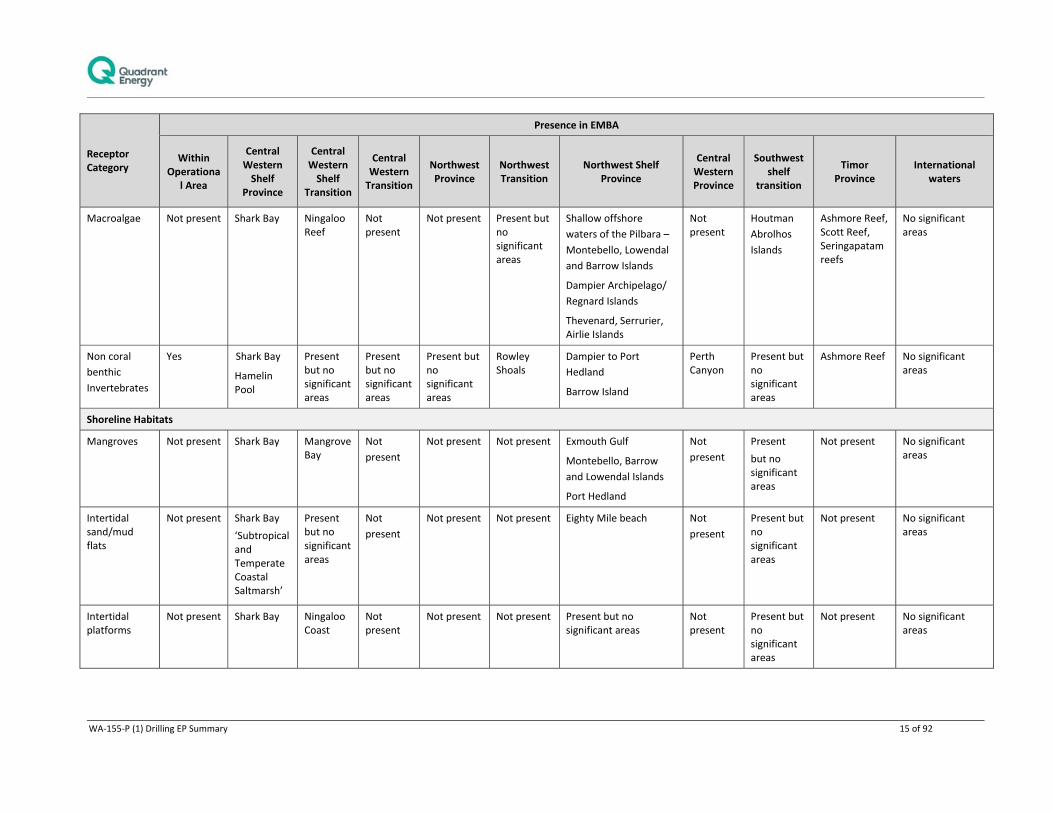
Given the spatial extent of the EMBA and the inclusion of shallow water and shoreline areas, there is a wide variety of marine and coastal habitats present. Table 4‐2 provides an indication of the distribution of these habitats within the geographical features identified in Figure 4‐1 and Figure 4‐5.

WA‐155‐P (1) Drilling EP Summary 14 of 92
Table 4‐2 Habitats associated within the geographical features identified within the EMBA
Receptor Category
Presence in EMBA
Within Operationa
l Area
Central Western Shelf
Province
Central Western Shelf
Transition
Central Western Transition
Northwest Province
Northwest Transition
Northwest Shelf Province
Central Western Province
Southwest shelf
transition
Timor Province
International waters
High Environmental Area (1,2,3)
(see Error! Reference source
not found.)
Ningaloo Coast Nth
Ningaloo Coast Sth
Outer
Ningaloo
Coast Nth
Outer Ningaloo Coast Nth
Outer NW
Ningaloo
Ningaloo Coast South
Outer
Abrolhos
Is Shoals
Outer NW Ningaloo
Outer
Ningaloo
Coast Nth
Eighty mile beach
Dampier Archipelago
Lowendal Is.
Montebello Is.
Barrow Is.
Barrow‐ Montebello Surrounds
Muiron Is.
Ningaloo Nth Coast
Exmouth Gulf Coast
Jurien CMR
Indonesia
Benthic Habitats
Coral reefs Not present Shark Bay
Bernier,
Dorre and
Dirk Hartog
Islands
Ningaloo Reef
Coral Bay
Not present
Present but no significant areas
Rowley
Shoals
(Imperieuse
Reef, Clerke
Reef,
Mermaid
Reef)
Dampier Archipelago
Montebello, Lowendal
and Barrow Islands
None
present
Houtman
Abrolhos
Islands
Rottnest
Island
Ashmore Reef,
Cartier Island,
Hibernia, Scott
and
Seringapatam
reefs
Christmas Island
Indonesia (west)
Seagrasses Not present Shark Bay Ningaloo Reef
Not present
Not present Rowley Shoals
Dampier Archipelago,
Regnard Islands
Mary Anne Reef
Onslow
Montebello and Barrow Islands
Not present
Houtman
Abrolhos
Islands
Perth Region
Rottnest Island
Ashmore Reef, Scott Reef, Seringapatam reefs
Indonesia (west)
WA‐155‐P (1) Drilling EP Summary 15 of 92
Receptor Category
Presence in EMBA
Within Operationa
l Area
Central Western Shelf
Province
Central Western Shelf
Transition
Central Western Transition
Northwest Province
Northwest Transition
Northwest Shelf Province
Central Western Province
Southwest shelf
transition
Timor Province
International waters
Macroalgae Not present Shark Bay Ningaloo Reef
Not present
Not present Present but no significant areas
Shallow offshore
waters of the Pilbara –
Montebello, Lowendal
and Barrow Islands
Dampier Archipelago/
Regnard Islands
Thevenard, Serrurier, Airlie Islands
Not present
Houtman
Abrolhos
Islands
Ashmore Reef, Scott Reef, Seringapatam reefs
No significant areas
Non coral
benthic
Invertebrates
Yes Shark Bay
Hamelin Pool
Present but no significant areas
Present but no significant areas
Present but no significant areas
Rowley Shoals
Dampier to Port
Hedland
Barrow Island
Perth Canyon
Present but no significant areas
Ashmore Reef No significant areas
Shoreline Habitats
Mangroves Not present Shark Bay Mangrove Bay
Not
present
Not present Not present Exmouth Gulf
Montebello, Barrow
and Lowendal Islands
Port Hedland
Not
present
Present
but no significant areas
Not present No significant areas
Intertidal sand/mud flats
Not present Shark Bay
‘Subtropical and Temperate Coastal Saltmarsh’
Present but no significant areas
Not
present
Not present Not present Eighty Mile beach Not
present
Present but no significant areas
Not present No significant areas
Intertidal platforms
Not present Shark Bay Ningaloo Coast
Not present
Not present Not present Present but no significant areas
Not present
Present but no significant areas
Not present No significant areas

WA‐155‐P (1) Drilling EP Summary 16 of 92
Receptor Category
Presence in EMBA
Within Operationa
l Area
Central Western Shelf
Province
Central Western Shelf
Transition
Central Western Transition
Northwest Province
Northwest Transition
Northwest Shelf Province
Central Western Province
Southwest shelf
transition
Timor Province
International waters
Sandy beaches
Not present Present but no significant areas
Present but no significant areas
Not present
Not present Not present Eighty Mile Beach Not present
Houtman Abrolhos Islands Rottnest Island
Not present No significant areas
Rocky shorelines
Not present Present but
no
significant
areas
Ningaloo
Coast
North‐West Cape
Not present
Not present Not present Present but no significant areas
Not present
Present but no significant areas
Not present No significant areas

WA‐155‐P (1) Drilling EP Summary 17 of 92
Figure 4‐2 Provincial Bio‐regions

WA‐155‐P (1) Drilling EP Summary 18 of 92
4.1.3 Commonwealth Marine Reserves, State Marine Parks and Marine Management Areas
Protected and significant areas with the potential to be impacted by this activity have been identified in Table 4‐3. This includes Commonwealth and State protected areas (Figure 4‐3) and KEFS (Figure 4‐4) present within the EMBA. The Muiron Islands Marine Management Area is adjacent to the Operational Area, all other identified values occur within the EMBA indicating that they could be contacted in the event of a hydrocarbon spill.
A short summary of the key areas of interest are described below.
Table 4‐3 Marine protected areas within the EMBA
Value/Sensitivity Distance from
Operational Area EMBA presence
Commonwealth Marine Reserves
504 km Abrolhos Commonwealth Marine Reserve
465.3 km Argo‐Rowley Terrace Commonwealth Marine Reserve
372.5 km Carnarvon Canyon Commonwealth Marine Reserve
282.2 km Dampier Commonwealth Marine Reserve
505.3 km Eighty Mile Beach Commonwealth Marine Reserve
49.6 km Gascoyne Commonwealth Marine Reserve
956 km Jurien Commonwealth Marine Reserve
851.1 km Kimberley Commonwealth Marine Reserve
715.5 km Mermaid Reef Commonwealth Marine Reserve
112.7 km Montebello Commonwealth Marine Reserve
28.8 km Ningaloo Commonwealth Marine Reserve
1125 km Perth Canyon Commonwealth Marine Reserve
327 km Shark Bay Commonwealth Marine Reserve
State Marine Parks (MP) and Marine Management Areas (MMA)
119.5 km Barrow Island MP
103.5 km Barrow Island MMA
148.1 km Montebello Islands MP
28.8 km Ningaloo MP
Adjacent Muiron Islands MMA
548.7 km Eighty Mile Beach MP
228.2 km Proposed Dampier Archipelago MP
World Heritage 8.88 km The Ningaloo coast
Wetlands of International Importance (Ramsar)
1520 km Hosnies springs
1528 km “the dales” Christmas Island
National Heritage Places 8.88 km The Ningaloo Coast
232.8 km Dampier Archipelago (including Burrup Peninsula)
103.5 km Barrow Island and the Montebello‐Barrow Islands Marine Conservation Reserves
765 km Batavia Shipwrecks Site and Survivor Camps Area 1629‐ Houtman Abrolhos
600 km HMAS Sydney II and HSK Kormoran Shipwreck Sites
Commonwealth Heritage Places
1514 km Christmas Island Natural Areas
8.88 km Ningaloo Marine Area – Commonwealth Waters

WA‐155‐P (1) Drilling EP Summary 19 of 92
Value/Sensitivity Distance from
Operational Area EMBA presence
15.5 km Ningaloo Marine Area – Commonwealth Waters
Threatened Ecological Communities
N/A
Key ecological feature (KEF)
4.93 km Ancient coastline at 125 m depth contour
685 km Ancient Coastline at 90m‐120m depth
937 km Canyons linking the Argo Abyssal Plain with the Scott Plateau
9.12 km Canyons linking the Cuvier Abyssal Plain and the Cape Range Peninsula
28.8 km Commonwealth waters adjacent to Ningaloo Reef
26.1 km Continental Slope Demersal Fish Communities
112.5 km Exmouth Plateau
299.1 km Glomar Shoals
517 km Wallaby Saddle
714 km Perth Canyon and adjacent shelf break, and other west coast canyons
725 km Commonwealth marine environment surrounding the Houtman Abrolhos Islands
485 km Western demersal slope and associated fish
684 km Western Rock Lobster
4.1.4 Muiron Islands Marine Management Area and Ningaloo Coast World Heritage Area (NCWHA)
The Operational Area is adjacent to the Muiron Islands Marine Management Area. The Muiron Islands, located 15 km northeast of the North West Cape comprises the North and South Muiron Islands and cover an area of 1,400 ha (AHC 2006). They are low limestone islands (maximum height of 18 m above sea level (ASL)) with some areas of sandy beaches, macroalgae and seagrass beds in the shallow waters (particularly on the eastern sides) and coral reef up to depths of 5 m, which surrounds both sides of South Muiron Island and the eastern side of North Muiron Island. The Muiron Islands MMA was WA’s first MMA, gazetted in November 2004. It covers an area of 28,616 ha and occurs entirely within State waters (CALM 2005).
The Muiron Islands MMA is part of the larger Ningaloo Marine Park, which is in turn part of the Ningaloo Coast World Heritage Area (NCWHA). The Marine Park protects a large portion of Ningaloo Reef, which stretches over 300 km from North West Cape south to Red Bluff. It is the largest fringing coral reef in Australia, forming a discontinuous barrier that encloses a lagoon that varies in width from 200 m to 7 km. Gaps that regularly intercept the main reef line provide channels for water exchange with deeper, cooler waters (CALM 2005). The Ningaloo Marine Park forms the backbone of the nature‐based tourism industry, and recreational activities in the Exmouth region. Seasonal aggregations of whale sharks, manta rays, sea turtles and whales, as well as the annual mass spawning of coral attract large numbers of visitors to Ningaloo each year (CALM 2005).
4.1.5 World Heritage Values and Management Principles
The NCWHA gained world heritage listing under criteria (vii), (viii) and (x) for containing:
superlative natural phenomena and areas of exceptional natural beauty and aesthetic importance;
outstanding examples representing major stages of Earth’s history, including the record of life, significant on‐going geological processes in the development of landforms, or significant geomorphic or physiographic features; and

WA‐155‐P (1) Drilling EP Summary 20 of 92
the most important and significant natural habitats for in situ conservation of biological diversity, including those containing threatened species of outstanding universal value from the point of view of science or conservation.
The Muiron Islands and Ningaloo Coast World Heritage Area is managed under a plan that is consistent with the World Heritage Convention and Australia's World Heritage management principles. World Heritage Management principles are set out in regulations and cover matters relevant to the preparation of management plans, the environmental assessment of actions that may affect the property and community consultation processes.
The Australian World Heritage management principles are outlined under Schedule 5 of the EPBC regulations (2000). The objective is to ensure that any likely impact of an action on the World Heritage values of the property should be considered. Any action should be consistent with the protection, conservation, presentation or transmission to future generations of the World Heritage values of the property.
4.1.6 Commonwealth Marine reserves
Abrolhos CMR
The Abrolhos CMR includes Marine National Park Zones (Marine National Park Zone – IUCN Category II‐; Habitat Protection Zone – IUCN Category VI; Multiple Use Zone – IUCN Category VI; Special Purpose Zone – IUCN Category VI) and provides important foraging areas for the
Threatened Australian lesser noddy;
Northernmost breeding colony of the threatened Australian sea lion; and
Migratory common noddy, wedge‐tailed shearwater, bridled tern, Caspian tern and roseate tern.
In addition, there are a number of examples of both deep and shallow ecosystems, seafloor features and canyons (DoE, 2014). Six KEFs are also present (see
Eighty Mile Beach MP
The Eighty Mile Beach Marine Park, located between Port Hedland and Broome, was gazetted on 29 January 2013. It covers an area of approximately 200,000ha stretching for some 220km from Cape Missiessy to Cape Keraudren, and includes sanctuary, recreation, general use and special purpose zones. The park is managed under the Eighty Mile Beach Marine Park Management Plan 2014‐20124 (DPaW, 2014). The listed ecological values of the Eighty Mile Beach Marine Park include the high sediment and water quality, the juxtaposition of the beach, coastal topography and seabed and the diverse and ecologically important habitats and marine/coastal flora and fauna. The listed habitat values of the marine park are as follows:
The intertidal sand and mudflat communities supporting a high abundance and diversity of
invertebrate life and providing a valuable food source for shorebirds (including migratory species)
and other fauna.
The diverse subtidal filter‐feeding communities.
Macroalgal and seagrass communities providing habitat and feeding opportunities for fish,
invertebrates and dugongs.
High diversity intertidal and subtidal coral reef communities.
Mangrove communities and adjacent saltmarshes provide nutrients to the surrounding waters and
habitat for fish and invertebrates.
The listed marine and coastal fauna values are as follows:
A high diversity and abundance of nationally and internationally important shorebirds and waders
(including migratory species) are found in the marine park.
Flatback turtles are endemic to northern Australia and nest at Eighty Mile Beach.

WA‐155‐P (1) Drilling EP Summary 21 of 92
Dugongs and several whale and dolphin species inhabit or migrate through the marine park.
A highly diverse marine invertebrate fauna provides an important food source for a variety of
animals, including birds, fish and turtles, along with recreational and commercial fishing
opportunities.
A diversity of fish species provide recreational and commercial fishing opportunities.
A diversity of sharks and rays, including several protected species, are found in the park.
In addition to these natural values, the marine park contains land and sea important to traditional indigenous owners through identity and place, family networks, spiritual practice and resource gathering. The marine park also has a history of European activity including exploration, pastoralism and commercial fishing (e.g. the pearl oyster fishery). The park contains a historical WWII plane wreck (Dornier Do‐24 X‐36) and shipwrecks (two pearl luggers). The marine park provides tourism opportunity and recreational value through its remoteness, diversity and abundance of habitats and marine fauna and the pristine nature of the marine and coastal environment.
The marine park contains vast intertidal sand and mudflats that extend up to 4km wide at low tide and provide a rich source of food for many species. Eighty Mile Beach Marine Park is one of the world's most important feeding grounds for small wading birds that migrate to the area each summer, travelling from countries thousands of kilometres away (DPaW 2014)

WA‐155‐P (1) Drilling EP Summary 22 of 92
Figure 4‐3 State and Commonwealth Marine Reserves within the EMBA

WA‐155‐P (1) Drilling EP Summary 23 of 92
).
Carnarvon Canyon CMR
The Carnarvon Canyon Commonwealth Marine Reserve (Habitat Protection Zone – IUCN Category IV) protects the following conservation values (DoE 2014):
The Carnarvon Canyon a single channel canyon with seabed features that include slope, continental rise and deep holes and valleys; the canyon ranges in depth from 1500 m to over 5,000 m, thereby providing habitat diversity for benthic and demersal species; and
Central Western Transition provincial bioregion ecosystem examples are found here, which are characteristic of the biogeographic faunal transition between tropical and temperate species.
Shark Bay CMR
The Shark Bay Commonwealth Marine Reserve (Multiple Use Zone – IUCN Category VI) protects the following conservation values (DoE 2014):
Foraging areas adjacent to important breeding areas for several species of migratory seabirds;
Part of the migratory pathway of protected humpback whales;
Waters that are adjacent to the largest nesting area for loggerhead turtles in Australia;
Shelf and slope habitats as well as a terrace feature;
Examples of the shallower ecosystems of the Central Western Shelf Province and Central Western Transition provincial bioregions including the Zutydorp meso‐scale bioregion; and
Connectivity between the inshore waters of the Shark Bay World Heritage Area and the deeper waters of the area.
Gascoyne CMR
The Gascoyne Commonwealth Marine Reserve (Multiple Use Zone – IUCN Category VI; Habitat Protection Zone – IUCN Category IV; Marine National Park Zone – IUCN Category II) protects the following conservation values (DoE 2014):
Important foraging areas for: migratory seabirds threatened and migratory hawksbills and flatback turtles; and vulnerable and migratory whale shark;
A continuous connectivity corridor from shallow depths around 15 m out to deep offshore waters on the abyssal plain at over 5,000 m in depth;
Seafloor features including canyon, terrace, ridge, knolls, deep hole/valley and continental rise. It also provides protection for sponge gardens in the south of the reserve adjacent to Western Australian coastal waters;
Ecosystems examples from the Central Western Shelf Transition, the Central Western Transition and the Northwest province provincial bioregions as well as the Ningaloo meso‐scale bioregion;
Three key ecological features;
The canyons in this reserve are believed to be associated with the movement of nutrients from deep water over the Cuvier Abyssal Plain onto the slope where mixing with overlying water layers occurs at the canyon heads. These canyon heads, including that of Cloates Canyon, are sites of species aggregation and are thought to play a significant role in maintaining the ecosystems and biodiversity associated with the adjacent Ningaloo Reef; and
The reserve therefore provides connectivity between the inshore waters of the existing Ningaloo Commonwealth marine park and the deeper waters of the area.
Ningaloo CMR

WA‐155‐P (1) Drilling EP Summary 24 of 92
Ningaloo Commonwealth Marine Reserve is approximately 300 km along the west coast of the Cape Range Peninsula near Exmouth, Western Australia (DSEWPaC 2012). Ningaloo Reef is the longest fringing barrier reef in Australia and is the only example in the world of extensive fringing coral reef on the west coast of a continent. It is included in the adjacent Western Australian Ningaloo Marine Park (State Waters), which lies between the Ningaloo Commonwealth Marine Reserve and the Western Australian coast (DSEWPaC 2012).
The Ningaloo Commonwealth Marine Reserve (Recreational Use Zone – IUCN Category II) protects the following conservation values (DoE 2014):
Important habitat (foraging areas) for vulnerable and migratory whale sharks;
Areas used for foraging by marine turtles adjacent to important nesting sites;
Part of the migratory pathway of the protected humpback whale;
Shallow shelf environments which provides protection for shelf and slope habitats, as well as pinnacle and terrace seafloor features; and
Seafloor habitats and communities of the Central Western Shelf Transition.
Montebello CMR
Drilling activities are proposed within the Montebello CMR (Multiple Use Zone – IUCN Category VI), the CMR protects the following conservation values (DoE 2014):
Foraging areas for migratory seabirds that are adjacent to important breeding areas;
Areas used by vulnerable and migratory whale sharks for foraging;
Foraging areas for marine turtles which are adjacent to important nesting sites;
Section of the north and south bound migratory pathway of the humpback whale;
Shallow shelf environments with depths ranging from 15–150 m which provides protection for shelf and slope habitats, as well as pinnacle and terrace seafloor features;
Seafloor habitats and communities of the Northwest Shelf Province provincial bioregions as well as the Pilbara (offshore) meso‐scale bioregion; and
One key ecological feature.
Argo‐Rowley CMR
The Argo‐Rowley Commonwealth Marine Reserve (Multiple Use Zone – IUCN Category VI; Marine National Park Zone – IUCN Category II) protects the following conservation values (DoE 2014):
Foraging areas that are important for migratory seabirds as well as the endangered loggerhead turtle;
Important habitat and foraging for sharks;
Protection for communities and habitats of the deeper offshore waters (220 metres to over 5,000 m) of the region;
Seafloor features including aprons and fans, canyons, continental rise, knolls/abyssal hills and the terrace and continental slope;
Communities and seafloor habitats of the Northwest Transition and Timor Province provincial bioregions;
Connectivity between the existing Mermaid Reef Marine National Nature Reserve and reefs of the Western Australian Rowley Shoals Marine Park and the deeper waters of the region;
Two key ecological features in the reserve.
Dampier Commonwealth Marine Reserve

WA‐155‐P (1) Drilling EP Summary 25 of 92
The Dampier Commonwealth Marine Reserve (Marine National Park Zone – IUCN Category II; Habitat Protection Zone – IUCN Category IV) covers an area of approximately 1,252 km2 and protects the following conservation values (DoE 2104):
Foraging areas for migratory seabirds that are adjacent to important breeding grounds;
Important foraging areas for marine turtles adjacent to significant nesting sites;
Part of the migratory pathway of the protected humpback whale;
Protection for offshore shelf habitats and shallow shelf habitats adjacent to the Dampier Archipelago; and
Communities and seafloor habitats of the Northwest Shelf Province provincial bioregion as well as the Pilbara (nearshore) and Pilbara (offshore) meso‐scale bioregions are included.
Eighty Mile Beach Commonwealth Marine Reserve
The Eighty Mile Beach Commonwealth Marine Reserve (Multiple Use Zone – IUCN Category VI) covers an area of approximately 10,785 km2 and protects the following conservation values (DoE 2014):
Foraging areas for migratory seabirds that are adjacent to important breeding grounds;
Important foraging areas for marine turtles adjacent to significant nesting sites;
Part of the migratory pathway of the protected humpback whale;
Areas adjacent to important foraging, nursing and pupping areas for freshwater, green and dwarf sawfish;
Protection for terrace, banks and shoal habitats on the shelf, with depths ranging from 15–70 m; and
Communities and seafloor habitats of the Northwest Shelf Province provincial bioregion and the Canning, Northwest Shelf, Pilbara (nearshore), Pilbara (offshore) and Eighty Mile Beach meso‐scale bioregions.
Jurien Commonwealth Marine Reserve
The Jurien Commonwealth Marine Reserve [Marine National Park Zone (IUCN Category II) – 31 km2 Special Purpose Zone (IUCN Category VI) – 1,820 km2] covers and area of approximately 1,851 km2 and protects the following conservation values (DoE 2014):
Important foraging areas for the:
o Threatened soft‐plumaged petrel; o Threatened Australian sea lion; o Threatened white shark; and o Migratory roseate tern, bridled tern, wedge‐tailed shearwater, and common noddy;
Important migration habitat for the protected humpback whale;
Examples of the ecosystems of two provincial bioregions: the central part of the South‐west Shelf
Transition (which includes the Central West Coast meso‐scale bioregion) and small parts of the
Central Western Province;
One key ecological feature; and
Heritage values represented by the SS Cambewarra historic shipwreck.
Kimberley Commonwealth Marine Reserve
The Kimberley Commonwealth Marine Reserve (Multiple Use Zone – IUCN Category VI; Habitat Protection Zone – IUCN Category IV; Marine National Park Zone – IUCN Category II) covers an area of approximately 74,469 km2 and protects the following conservation values (DoE 2014):

WA‐155‐P (1) Drilling EP Summary 26 of 92
Important foraging areas for migratory seabirds, migratory dugongs, dolphins and threatened and
migratory marine turtles;
Important migration pathway and nursery areas for the protected humpback whale;
Adjacent to important foraging and pupping areas for sawfish and important nesting sites for green
turtles;
Protection for communities and habitats of waters offshore of the Kimberley coastline (ranging in
depth from less than 15–800 m);
Representation of continental shelf, slope, plateau, pinnacle, terrace, banks and shoals and deep
hole/valley seafloor features;
Communities and seafloor habitats of the Northwest Shelf Transition, Northwest Shelf Province and
Timor Province provincial bioregions along with the Kimberley, Canning, Northwest Shelf and
Oceanic Shoals meso‐scale bioregions; and
Two key ecological features included in the reserve are:
o Ancient coastline (an area of enhanced productivity attracting baitfish which, in turn,
supplies food for migrating species); and
o Continental slope demersal fish communities (the second richest area for demersal fish
species in Australia).
Mermaid Reef Commonwealth Marine Reserve
The Mermaid Reef Commonwealth Marine Reserve (Strict Nature Reserve – IUCN Category Ia) has been re‐named from the previous Mermaid Reef Marine National Nature Reserve and covers an area of approximately 540 km2. During periods of high tide, Mermaid Reef is completely submerged underwater, and therefore, is under the legal jurisdiction of the Australian Commonwealth government (DSEWPaC 2012). The reef is listed on Australia’s Commonwealth Heritage List and protects the following conservation values (DoE 2014):
National and international significant habitats including, coral formations, geomorphic features and
diverse marine life;
Key area for over 200 species of hard corals and 12 classes of soft corals with coral formations in
pristine condition;
Important areas for sharks including the grey reef shark, the white tip reef shark and the silvertip
whaler;
Important foraging area for marine turtles;
Important area for toothed whales, dolphins, tuna and billfish;
Important resting and feeding sites for migratory seabirds;
The reserve, along with nearby Rowley Shoals Marine Park, provides the best geological example of
shelf atolls in Australia; and
Examples of the seafloor habitats and communities of the Northwest Transition.
Perth Canyon Commonwealth Marine Reserve
Perth Canyon Commonwealth Marine Reserve (Marine National Park Zone – IUCN Category II – 1,107 km2; Habitat Protection Zone – IUCN Category IV – 2,569 km2; Multiple Use Zone – IUCN Category VI – 3,733 km2) covers an area of approximately 7,409 km2 and protects the following conservation values (DoE 2014):
Globally important seasonal feeding aggregation for the threatened blue whale;
Important foraging areas for the:
o Threatened soft‐plumaged petrel;
o Migratory sperm whale; and

WA‐155‐P (1) Drilling EP Summary 27 of 92
o Migratory wedge‐tailed shearwater.
Important migratory areas for protected humpback whales;
Examples of the ecosystems of the southernmost parts of the Central Western Province and South‐
west Shelf Transition (including the Central West Coast meso‐scale bioregion), and the
northernmost parts of the South‐west Transition and Southwest Shelf Province (including the
Leeuwin‐Naturaliste meso‐scale bioregion); and
Three key ecological features.
4.1.7 State Marine Parks and Marine Management Areas
Barrow Island MP
The Barrow Island Marine Park covers 4,169 ha, all of which is zoned as sanctuary zone (the Western Barrow Island Sanctuary Zone) (DEC 2007). It includes Biggada Reef, an ecologically significant fringing reef, and Turtle Bay, an important turtle aggregation and breeding area (DEC 2007). Representative areas of seagrass, macroalgal and deep water habitat are also represented within the marine park (DEC 2007). Passive recreational activities (such as snorkelling, diving and boating) are permitted but extractive activities such as fishing and hunting are not.
Barrow Island MMA
The Barrow Island Marine Management Area (MMA) is the largest reserve within the Montebello/Barrow Islands marine conservation reserves (DEC 2007)and includes most of the waters around Barrow Island, the Lowendal Islands and the Barrow Island Marine Park, with the exclusion of the port areas of Barrow Island and Varanus Island.
The MMA is not zoned apart from one specific management zone: the Bandicoot Bay Conservation Area. This conservation area is on the southern coast of Barrow Island and has been created to protect benthic fauna and seabirds. It includes the largest intertidal sand/mudflat community in the reserves, is known to be high in invertebrate diversity and is an important feeding area for migratory birds.
As for the other reserves in the Montebello/Barrow Islands marine conservation reserves, the Barrow Island MMA includes significant breeding and nesting areas for marine turtles and the waters support a diversity of tropical marine fauna, important coral reefs and unique mangrove communities (DEC 2007). Green, hawksbill and flatback turtles regularly use the island’s beaches for breeding, and loggerhead turtles are also occasionally sighted.
Montebello Islands MP
The Montebello Islands Marine Park (MP) is an ‘A’ Class reserve (DEC 2007) and its northern and western boundaries follow the seaward extent of Western Australian state waters (DEC 2007). Zoning within the Montebello Islands MP is a combination of sanctuary, recreation, special purpose (benthic protection), special purpose (pearling), and general use (DEC 2007).
The Montebello Islands comprise over 100 islands, the majority of which are rocky outcrops; rocky shore accounts for 81% of shoreline habitat (DEC 2007). Other marine habitats within the marine park include coral reefs, mangroves, intertidal flats, extensive sheltered lagoonal waters, and shallow algal and seagrass reef platform extending to the south of the Montebello Islands to the Rowley Shelf.
Ecologically, the marine park’s values include important turtle nesting sites, feeding and resting areas for migrating shorebirds, seabird nesting areas, dugong foraging areas, globally‐unique mangrove communities, and highly diverse fish and invertebrate assemblages (DEC 2007). Also, the sediment and water quality of the marine park are considered pristine (DEC 2007) and are essential to the maintenance of the marine ecosystems and associated biota.
Economic values within the Montebello Islands MP include commercial pearl culture, commercial line and trap fishing, and an increasing recreational usage (DEC 2007). Special purpose zones for pearling are established for the existing leaseholder to allow pearling to be the priority use of these areas (DEC 2007).

WA‐155‐P (1) Drilling EP Summary 28 of 92
Commercial fishing includes a trap fishery for reef fishes, mainly in water depths of 30–100 m, and wet lining for reef fish and mackerel. Fish trawling also occurs in the waters near to the Montebello Islands. A tourist houseboat operates out of Claret Bay, at the southern end of Hermite Island, during the winter months. The Montebello Islands are becoming more frequently used by recreational boaters for camping, fishing and diving activities.
Eighty Mile Beach MP
The Eighty Mile Beach Marine Park, located between Port Hedland and Broome, was gazetted on 29 January 2013. It covers an area of approximately 200,000ha stretching for some 220km from Cape Missiessy to Cape Keraudren, and includes sanctuary, recreation, general use and special purpose zones. The park is managed under the Eighty Mile Beach Marine Park Management Plan 2014‐20124 (DPaW, 2014). The listed ecological values of the Eighty Mile Beach Marine Park include the high sediment and water quality, the juxtaposition of the beach, coastal topography and seabed and the diverse and ecologically important habitats and marine/coastal flora and fauna. The listed habitat values of the marine park are as follows:
The intertidal sand and mudflat communities supporting a high abundance and diversity of
invertebrate life and providing a valuable food source for shorebirds (including migratory species)
and other fauna.
The diverse subtidal filter‐feeding communities.
Macroalgal and seagrass communities providing habitat and feeding opportunities for fish,
invertebrates and dugongs.
High diversity intertidal and subtidal coral reef communities.
Mangrove communities and adjacent saltmarshes provide nutrients to the surrounding waters and
habitat for fish and invertebrates.
The listed marine and coastal fauna values are as follows:
A high diversity and abundance of nationally and internationally important shorebirds and waders
(including migratory species) are found in the marine park.
Flatback turtles are endemic to northern Australia and nest at Eighty Mile Beach.
Dugongs and several whale and dolphin species inhabit or migrate through the marine park.
A highly diverse marine invertebrate fauna provides an important food source for a variety of
animals, including birds, fish and turtles, along with recreational and commercial fishing
opportunities.
A diversity of fish species provide recreational and commercial fishing opportunities.
A diversity of sharks and rays, including several protected species, are found in the park.
In addition to these natural values, the marine park contains land and sea important to traditional indigenous owners through identity and place, family networks, spiritual practice and resource gathering. The marine park also has a history of European activity including exploration, pastoralism and commercial fishing (e.g. the pearl oyster fishery). The park contains a historical WWII plane wreck (Dornier Do‐24 X‐36) and shipwrecks (two pearl luggers). The marine park provides tourism opportunity and recreational value through its remoteness, diversity and abundance of habitats and marine fauna and the pristine nature of the marine and coastal environment.
The marine park contains vast intertidal sand and mudflats that extend up to 4km wide at low tide and provide a rich source of food for many species. Eighty Mile Beach Marine Park is one of the world's most important feeding grounds for small wading birds that migrate to the area each summer, travelling from countries thousands of kilometres away (DPaW 2014)

WA‐155‐P (1) Drilling EP Summary 29 of 92
Figure 4‐3 State and Commonwealth Marine Reserves within the EMBA

WA‐155‐P (1) Drilling EP Summary 30 of 92
4.1.8 Key Ecological Features within the EMBA
Ancient coastline at 125 m depth contour
The shelf of the North‐west Marine Region contains several terraces and steps which reflect changes in sea level that occurred over the last 100,000 years. The most prominent of these features occurs at a depth of 125 m as an escarpment along the North West Shelf and Sahul Shelf (DSEWPaC 2012). Where the ancient submerged coastline provides areas of hard substrate it may contribute to higher biological diversity. Little detailed knowledge is available, but the hard substrate of the escarpment is likely to support sponges, corals, crinoids, molluscs, echinoderms (DSEWPaC 2012).
Parts of the ancient coastline are thought to provide biologically important habitats in areas otherwise dominated by soft sediments. The topographic complexity of these escarpments may also facilitate vertical mixing of the water column providing a relatively nutrient‐rich environment for species present on the escarpment (DSEWPaC 2012).
Canyons linking the Cuvier Abyssal Plain with the Cape Range Peninsula
Cape Range Peninsula and the Cuvier Abyssal Plain are linked by canyons, the largest of which are the Cape Range Canyon and Cloates Canyon. These two canyons are located along the southerly edge of Exmouth Plateau adjacent to Ningaloo Reef and are unique due to their close proximity to the North West Cape (DSEWPaC 2012).
The Leeuwin Current interacts with the heads of the canyons to produce eddies resulting in delivery of higher nutrient, cool waters from the Antarctic intermediate water mass to the shelf (Brewer et al. 2007). Strong internal tides also create upwelling at the canyon heads (Brewer et al. 2007). Thus the canyons, the Exmouth Plateau and the Commonwealth waters adjacent to Ningaloo Reef interact to create the conditions for enhanced productivity seen in this region (Sleeman et al. 2007 in DSEWPaC 2012). The canyons are also repositories for particulate matter deposited from the shelf and sides of the canyons and serve as conduits for organic matter between the surface, shelf and abyssal plains (DSEWPaC 2012).
The canyons that link the Cuvier Abyssal Plain with the continental slope off Cape Range Peninsula are believed to support the productivity and species richness of Ningaloo Reef (DSEWPaC 2012).
Commonwealth waters surrounding Ningaloo Reef
The Ningaloo Reef extends almost 300 km along the Cape Range Peninsula to the Red Bluff. Commonwealth waters adjacent to the reef are thought to support the rich aggregations of marine species at Ningaloo Reef through upwellings associated with canyons on the adjacent continental slope and interactions between the Ningaloo and Leeuwin currents (Brewer et al. 2007, DEWHA 2008, DSEWPaC 2012). The narrow continental shelf (10 km at its narrowest) means that the nutrients channelled to the surface via canyons are immediately available to reef species. Terrestrial nutrient input is low, hence this deepwater source is a major source of nutrients for Ningaloo Reef and therefore very important in maintaining this system (DEWHA 2008).
The Ningaloo Commonwealth Marine Reserve includes this Key Ecological Feature and is discussed in Section 4.1.2.
Continental slope demersal fish communities
The Australian continental slope provides important habitat for demersal fish communities, characterised by high endemism and species diversity. Specifically, the continental slope between North West Cape and the Montebello Trough is the most diverse slope bioregion in Australia with more than 500 fish species, 76 of which are endemic (Last et al. 2005 in DSEWPaC 2012). The Timor Province and Northwest Transition bioregions are the second‐richest areas for demersal fish across the entire continental slope (DSEWPaC 2012).
Exmouth Plateau
The Exmouth Plateau covers an area of 49,310 km2 and is located approximately 150 km northwest of Exmouth. The plateau ranges in water depths from 800 to 4,000 m (Heap & Harris 2008 in DSEWPaC 2012).

WA‐155‐P (1) Drilling EP Summary 31 of 92
The plateau’s surface is rough and undulating at 800–1,000 m depth. The northern margin is steep and intersected by large canyons (e.g. Montebello and Swan canyons) with relief greater than 50 m. The western margin is moderately steep and smooth and the southern margin is gently sloping and virtually free of canyons (Falkner et al. 2009 in DSEWPaC 2012).
The Exmouth Plateau is a regionally and nationally unique tropical deep sea plateau. It may serve an important ecological role by acting as a topographic obstacle that modifies the flow of deep waters that generate internal tides, causing upwelling of deeper water nutrients closer to the surface (Brewer et al. 2007).
Glomar Shoals
The Glomar Shoals are a submerged feature situated at a depth of 33–77 m, approximately 150 km north of Dampier on the Rowley Shelf (Falkner et al. 2009 in DSEWPaC 2012). They consist of a high percentage of marine‐derived sediments with high carbonate content and gravels of weathered coralline algae and shells (McLoughlin & Young 1985 in DSEWPaC 2012). The area’s higher concentrations of coarse material compared to surrounding areas are indicative of a high energy environment subject to strong seafloor currents (Falkner et al. 2009 in DSEWPaC 2012).
Biological communities found at the Glomar Shoals have not been comprehensively studied, however the shoals are known to be an important area for a number of commercial and recreational fish species such as rankin cod, brown striped snapper, red emperor, crimson snapper, bream and yellow‐spotted triggerfish. Catch rates at the Glomar Shoals are high, indicating that the area is a region of high productivity (Falkner et al. 2009, Fletcher & Santoro 2009 in DSEWPaC 2012).
The Glomar Shoals are regionally important for their potentially high biological diversity and localised productivity. Biological data specific to the Glomar Shoals is limited, however the fish of the shoals are probably a subset of reef‐dependent species and anecdotal evidence suggests they are particularly abundant (DSEWPaC 2012).
Ancient Coastline at 90m‐120m depth
This coastline is found in the South‐west Marine Region and contains several terraces and steps reflecting a gradual increase in sea level across the shelf that occurred during the Holocene. The most prominent of these occurs close to the middle of the continental shelf off the Great Australian Bight at a depth of 90‐120 m. The area has important conservation value due to its potential for high productivity, biodiversity and aggregations of marine life. Benthic biodiversity and productivity occur where the ancient coastline forms a prominent escarpment of exposed hard substrates, where it is dominated by sponge communities of significant biodiversity and structural complexity (DSEWPaC 2012).
Canyons linking the Argo Abyssal Plain with the Scott Plateau
The Scott Plateau connects with the Argo Abyssal Plain via a series of canyons, the largest of which are the Bowers and Oates canyons (DSEWPaC 2012). The canyons cut deeply into the south‐west margin of the Scott Plateau and act as conduits for transport of sediments from an approximate depth of 2,000–3,000 m to depths of more than 5,500 m (DSEWPaC 2012). The water masses at these depths are deep Indian Ocean water on the Scott Plateau and Antarctic bottom water on the Argo Abyssal Plain. Both water masses are cold, dense and nutrient‐rich (Lyne et al. 2006 in DSEWPaC 2012).
The canyons linking the Argo Abyssal Plain and Scott Plateau are likely to be important features due to their historical association with sperm whale aggregations (DSEWPaC 2012).
Wallaby Saddle
The Wallaby Saddle is an abyssal geomorphic feature located on the upper continental slope at a depth of 4,000–4,700 m (DSEWPaC 2012). The feature connects north‐west margin of the Wallaby Plateau with the margin of the Carnarvon Terrace (Falkner et al. 2009 in DSEWPaC 2012).
The Wallaby Saddle is situated within the Indian Ocean water mass and is thus differentiated from systems to the north that are dominated by transitional fronts or the Indonesian Throughflow (DSEWPaC 2012).

WA‐155‐P (1) Drilling EP Summary 32 of 92
Little is known about the Wallaby Saddle; however, the area is considered one of enhanced productivity and low habitat diversity (Brewer et al. 2007). The Wallaby Saddle is associated with historical aggregations of sperm whales (DEWHA 2008a).
Perth Canyon and adjacent shelf break, and other west coast canyons
The Perth Canyon is the largest known undersea canyon in Australian waters. Deep ocean currents rise to the surface, creating a nutrient‐rich cold‐water habitat attracting feeding aggregations of deep‐diving mammals, such as pygmy blue whales and large predatory fish that feed on aggregations of small fish, krill and squid (DSEWPaC 2012).
Commonwealth marine environment surrounding the Houtman Abrolhos Islands
The Houtman Abrolhos Islands and surrounding reefs support a unique mix of temperate and tropical species, resulting from the southward transport of species by the Leeuwin Current over thousands of years. The Houtman Abrolhos Islands are the largest seabird breeding station in the eastern Indian Ocean (DSEWPaC 2012). They support more than one million pairs of breeding seabirds.
Western demersal slope and associated fish
The western demersal slope provides important habitat for demersal fish communities, with a high level of diversity and endemism. A diverse assemblage of demersal fish species below a depth of 400 m is dominated by relatively small benthic species such as grenadiers, dogfish and cucumber fish. Unlike other slope fish communities in Australia, many of these species display unique physical adaptations to feed on the sea floor (such as a mouth position adapted to bottom feeding), and many do not appear to migrate vertically in their daily feeding habits (DSEWPaC ‐2012).
Western Rock Lobster
This species is the dominant large benthic invertebrate in the region. The lobster plays an important trophic role in many of the inshore ecosystems of the South‐west Marine Region. Western rock lobsters are an important part of the food web on the inner shelf, particularly as juveniles (DSEWPaC 2012).

WA‐155‐P (1) Drilling EP Summary 33 of 92
Figure 4‐4 KEFS within the EMBA

WA‐155‐P (1) Drilling EP Summary 34 of 92
4.1.9 National Heritage Places
National and Commonwealth Places with the potential to be impacted by this program have been identified in Table 4‐3. No Heritage places occur within the Operational Area, all identified values occur within the EMBA indicating that they could be contacted in the event of a hydrocarbon spill.
Ningaloo Coast
The Ningaloo Coast is a listed place included on the World Heritage List in 2011 and was inscribed for outstanding natural universal values:
• An example of superlative natural phenomena; and
• Containing important and significant habitats for in situ conservation of biological diversity.
The Ningaloo Coast WHA includes (DEWHA 2010):
• Ningaloo Commonwealth Marine Reserve (previously named Ningaloo Marine Park – Commonwealth waters);
• Ningaloo Marine Park (Western Australia state waters);
• Muiron Island Marine Management Area (including the Muiron Islands);
• Jurabi Coastal Park;
• Bundegi Coastal Park;
• Cape Range National Park; and
• Learmonth Air Weapons Range.
Barrow Island and the Montebello‐Barrow Islands Marine Conservation Reserves
These are a Nominated Place, discussed in further detail in Section 4.1.1.
Dampier Archipelago (including Burrup Peninsula)
Dampier Archipelago was included on the National Heritage List in July 2007. Approximately 36,860 ha at Dampier were listed, comprising parts of the Burrup Peninsula and surrounding islands. Reefs, shoals and islands of the Dampier Archipelago provide important habitat for many native plant and animals. The Burrup Peninsula includes Aboriginal rock art where engravings provide an outstanding visual record of Australia’s history. The area contains one of the densest concentrations of rock engravings in Australia with some sites containing thousands or tens of thousands of images. There is a high density of stone arrangements on the Burrup Peninsula including standing stones, stone pits and more complex circular stone arrangements (Commonwealth of Australia 2007).
Batavia Shipwrecks Site
The Batavia was included on the National Heritage List in 2006. This shipwreck is the oldest of the known Verenigde Oost‐Indische Compagnie (VOC) wrecks on the WA coast and has a unique place in Australian shipwrecks. Because of its relatively undisturbed nature the archaeological investigation of the wreck itself has revealed a range of objects of considerable value to the artefact specialist and historian. The recovered sections of the hull of the Bataviathat have been reconstructed in the Western Australian Maritime Museum and provides information on 17th century Dutch ship building techniques, while the remains of the cargo carried by the vessel have provided economic, and social evidence of the operation of the Dutch port at Batavia (now Jakarta) in the early 17th century (DoE 2014d).
Houtman Abrolhos
The Houtman Abrolhos Marine Area was registered on the national estate in October 1998. The Abrolhos includes species which are at or near the extremes of their range of distribution. The coral reefs have biogeographic significance as the most southerly reefs of their types in the Indian Ocean. Houtman

WA‐155‐P (1) Drilling EP Summary 35 of 92
Abrolhos Marine Area is essential for the maintenance of tropical elements in the marine flora and fauna of southern parts of the Western Australian coast. The location of the place in the Leeuwin Current and the provision of warmer temperatures, higher nutrients and larvae of tropical organisms by the Current allow a diversity of species including a mix of tropical and temperate species to persist at the place and to disperse to areas further south. The Abrolhos are among the most significant seabird breeding areas in the world with rookeries of twenty species which use the marine areas as part of their breeding habitat (DoE 2014d).
HMAS Sydney II and HSK Kormoran Shipwreck Sites
The naval battle fought in 1941 between the Australian warship HMAS Sydney II and the German commerce raider HSK Kormoran off the Western Australian coast during World War II was a defining event in Australia’s cultural history. The loss of HMAS Sydney II, along with its entire crew of 645 following the battle with HSK Kormoran, remains Australia’s worst naval disaster (DoE 2014d).
The shipwreck sites are comprised of two areas located approximately 290 km west‐southwest of Carnarvon. The shipwrecks of the HMAS Sydney II and HSK Kormoran are located on the seabed approximately 22 km apart (DoE 2014d).
4.1.10 Hot Spots
The locations that have been ranked priority 1, 2 or 3 (identified in Quadrant Energy’s Environmental Sensitivities and Priorities for Protection guidelines EA‐91‐ZI‐10008) that occur within the EMBA are illustrated in Figure 4‐5. These areas are considered to have High Environmental Value (HEV) regionally.

WA‐155‐P (1) Drilling EP Summary 36 of 92
Figure 4‐5 High Environmental Value areas (hotspots) within the EMBA

WA‐155‐P (1) Drilling EP Summary 37 of 92
4.1.11 Marine Fauna
Desktop searches of the Operational Area and larger EMBA were undertaken using DoE’s Protected Matters Search Tool for the purposes of identifying species listed under the EPBC Act. The search identified 76 Listed Threatened Species (LTS) and 89 Listed Migratory Species (LMS) as having the potential to occur within the EMBA.
An assessment of all the marine and coastal species was undertaken to identify if these species have the potential to occur in either the Operational Area or larger EMBA. Those listed threatened or vulnerable species that have been identified as likely to be present in the Operational Area or EMBA are summarised in Table 4‐4. Migratory species are only listed if also threatened or vulnerable.

WA‐155‐P (1) Drilling EP Summary 38 of 92
Table 4‐4: Environmental values and sensitivities – marine fauna
Value/Sensitivity EPBC Act Status
CE = Critically Endangered
E = Endangered
V = Vulnerable
M = Migratory
Operational Area presence2
Particular values or sensitivities within
EMBA
Particular values or sensitivities within Operational Area
Relevant Events Common Name Scientific Name
Protected Species and Communities: Fish and Sharks
Whale Shark Rhincodon typus V,M
Foraging, feeding or related behaviour known to occur within area
Known aggregation area April–June in Exmouth approx. 10km away
Important feeding habitat in Ningaloo
Planned
Operational Discharges
Drilling Discharges
Unplanned
Hydrocarbon
Release
Non‐hydrocarbon
release
Grey Nurse Shark (west coast population)
Carcharias taurus V Species or species habitat known to occur within area
Nil N/A
Great White Shark Carcharodon carcharias
V,M
Foraging, feeding or related behaviour known to occur within area
Nil N/A
Dwarf Sawfish Pristis clavata V Unlikely Breeding known to occur within area
Nil N/A
Green Sawfish Pristis zijsron V Unlikely Breeding known to occur within area
Nil N/A
Blind Gudgeon Milyeringa veritas V Unlikely Species or species Nil N/A
2 Determined from an EPBC search of the Outtrim East‐1 Operational Area permit boundaries

WA‐155‐P (1) Drilling EP Summary 39 of 92
Value/Sensitivity EPBC Act Status
CE = Critically Endangered
E = Endangered
V = Vulnerable
M = Migratory
Operational Area presence2
Particular values or sensitivities within
EMBA
Particular values or sensitivities within Operational Area
Relevant Events Common Name Scientific Name
habitat likely to occur within area
Blind Cave Eel Ophisternon candidum V Unlikely Species or species habitat likely to occur within area
Nil N/A
Shortfin Mako Isurus oxyrinchus M Species or species habitat likely to occur within area
Transient individuals may occur
Longfin Mako Isurus paucus M Species or species habitat likely to occur within area
Transient individuals may occur
Giant Manta Ray Manta birostris M Species or species habitat known to occur within area
Transient individuals may occur
Protected Species and Communities: Marine Mammals
Sei Whale Balaenoptera borealis V, M Unlikely Species or species habitat may occur within area
Rare and unlikely to be in the area N/A
Blue whale Balaenoptera musculus E,M
Foraging, feeding or related behaviour known to occur within area
Migration route known to overlap EMBA.
Deep water species
N/A
Fin Whale Baleenoptera physalus V, M Unlikely
Species or species habitat may occur within area
Rare and unlikely to be in the area.
There are no known mating or calving areas in Australian waters
N/A
Southern Right Whale Eubalaena australis E, M
Breeding known to occur within area
The Southern Right Whale is seasonally present on the Australian coast between
May and November.
Peak periods for mating are from mid‐
N/A

WA‐155‐P (1) Drilling EP Summary 40 of 92
Value/Sensitivity EPBC Act Status
CE = Critically Endangered
E = Endangered
V = Vulnerable
M = Migratory
Operational Area presence2
Particular values or sensitivities within
EMBA
Particular values or sensitivities within Operational Area
Relevant Events Common Name Scientific Name
July through August.
There are no known biologically important areas for this species between Busselton and the Northern Territory
border
Humpback Whale Megaptera novaeangliae
V,M
Congregation or aggregation known to occur within area
Migration route known to overlap EMBA
Humpback whales associated with peak migrations are expected to pass through
(or near) the Operational Area
N/A
Australian Sea‐lion Neophoca cinerea V Unlikely Breeding known to occur within area
Nil N/A
Antarctic Minke Whale Balaenoptera bonaerensis
M Species or species habitat may occur within area
Transient individuals may occur
Bryde’s Whale Balaenoptera edeni M Species or species habitat may occur within area
Transient individuals may occur
Killer Whale Orcinus orca M Species or species habitat may occur within area
Transient individuals may occur
Sperm Whale Physeter macrocephalus
M
Foraging, feeding or related behaviour known to occur within area
Transient individuals may occur
Spotted Bottlenose Dolphin
Tursiops aduncus M Species or species habitat likely to occur within area
Transient individuals may occur
Protected Species and Communities: Marine Reptiles
Loggerhead Turtle Caretta caretta E,M Breeding known to occur Unlikely: too deep for adult internesting N/A

WA‐155‐P (1) Drilling EP Summary 41 of 92
Value/Sensitivity EPBC Act Status
CE = Critically Endangered
E = Endangered
V = Vulnerable
M = Migratory
Operational Area presence2
Particular values or sensitivities within
EMBA
Particular values or sensitivities within Operational Area
Relevant Events Common Name Scientific Name
within area or foraging areas. Nesting occurs from Shark Bay to southern areas of NWS.
Closest nesting areas at Muiron Islands, 12.7 km south. Small likelihood of
migrating adults
Green Turtle Chelonia mydas V,M
Breeding known to occur within area
Closest nesting area occurs at Muiron Islands, 12.7 km south. Some likelihood
of transient adults or foraging hatchlings/juveniles
N/A
Leatherback Turtle Dermochelys coriacea E,M
Foraging, feeding or related behaviour known to occur within area
No nesting areas in WA. Small likelihood of transient adults and juveniles
N/A
Hawksbill Turtle Eretmochelys imbricata
V,M
Breeding known to occur within area
Closest nesting area occurs at Muiron Islands, 12.7 km south. Small likelihood
of transient adults or foraging hatchlings/juveniles
N/A
Olive Ridley Turtle Lepidochelys olivacea E, M Unlikely Foraging, feeding or related behaviour likely to occur within area
Nil N/A
Flatback Turtle Natator depressus V,M
Breeding known to occur within area
Closest nesting areas at Muiron Islands, 12.7 km south.
Small likelihood of transient adults or foraging hatchlings/juveniles
N/A
Short‐nosed Seasnake Aipysurus apraefrontalis
CE Species or species habitat known to occur within area
Unlikely. Species prefers shallow water. Resident throughout the year in
Exmouth Gulf N/A
Protected Species and Communities: Marine Birds
Australian lesser noddy
Anous tenuirostris melanops
V Unlikely Breeding known to occur within area
Nil

WA‐155‐P (1) Drilling EP Summary 42 of 92
Value/Sensitivity EPBC Act Status
CE = Critically Endangered
E = Endangered
V = Vulnerable
M = Migratory
Operational Area presence2
Particular values or sensitivities within
EMBA
Particular values or sensitivities within Operational Area
Relevant Events Common Name Scientific Name
Southern Royal Albatross
Diomedea epomophora epomophora
V, M Unlikely Foraging, feeding or related behaviour likely to occur within area
Nil
Northern Royal Albatross
Diomedea epomophora sanfordi E, M
Unlikely Foraging, feeding or related behaviour likely to occur within area
Nil
Amsterdam Albatross Diomedea exulans amsterdamensis E, M
Unlikely Species or species habitat may occur within area
Nil
Tristan Albatross Diomedea exulans exulans (D. dabbenena)
E, M Unlikely Species or species
habitat may occur within area
Nil
Wandering Albatross Diomedea exulans (sensu lato) V, M
Unlikely Foraging, feeding or related behaviour likely to occur within area
Nil
Christmas Island Frigatebird, Andrew’s Frigatebird
Fregata andrewsi V, M Unlikely
Breeding known to occur within area Nil
Blue petrel Halobaena caerulea V Unlikely
Species or species habitat may occur within area
Nil
Southern Giant‐Petrel Macronectes giganteus
E, M
Species or species habitat may occur within area
No biologically important areas for this species identified in the area from Busselton to the Northern Territory
border
Northern Giant‐Petrel Macronectes halli V, M Unlikely
Species or species habitat may occur within area
Nil
White‐winged Fairy‐ Malurus leucopterus V Unlikely Species or species Nil N/A

WA‐155‐P (1) Drilling EP Summary 43 of 92
Value/Sensitivity EPBC Act Status
CE = Critically Endangered
E = Endangered
V = Vulnerable
M = Migratory
Operational Area presence2
Particular values or sensitivities within
EMBA
Particular values or sensitivities within Operational Area
Relevant Events Common Name Scientific Name
Wren (Barrow Island) edouardi habitat likely to occur within area
Christmas Island Hawk‐Owl
Ninox natalis V Unlikely
Species or species habitat likely to occur within area
Nil
Abbott’s Booby Papasula abbotti E, M Unlikely
Breeding likely to occur within area
Nil
White tailed Tropicbird (Christmas Island)
Phaethon lepturus fulvus
E, M Unlikely Breeding likely to occur within area
Nil
Soft‐plumaged Petrel Pterodroma mollis V Possible
Foraging, feeding or related behaviour known to occur within area
No biologically important areas for this species identified in the area from Busselton to the Northern Territory
border
N/A
Australian Painted Snipe
Rostratula australis E, M Unlikely
Species or species habitat may occur within area
Nil N/A
Australian Fairy Tern Sternula nereis nereis
V Unlikely
Species or species habitat known to occur within area
13 Pilbara and Gascoyne islands identified as important breeding areas according to the National Conservation
Values. August‐ February
N/A
Indian yellow‐nosed albatross
Thalassarche carteri V, M Unlikely
Foraging, feeding or related behaviour may occur within area
Nil
White‐capped Albatross
Thalassarche cauta steadi
V, M Unlikely Species or species habitat likely to occur within area
Nil N/A
Black‐browed Albatross
Thalassarche melanophris
V, M Unlikely Species or species habitat may occur within area
Nil N/A

WA‐155‐P (1) Drilling EP Summary 44 of 92
Value/Sensitivity EPBC Act Status
CE = Critically Endangered
E = Endangered
V = Vulnerable
M = Migratory
Operational Area presence2
Particular values or sensitivities within
EMBA
Particular values or sensitivities within Operational Area
Relevant Events Common Name Scientific Name
Campbell Albatross Thalassarche melanophris impavida
V, M Unlikely Species or species habitat may occur within area
Nil N/A
Other
Cape Range Remipede Kumonga exleyi V Unlikely Species or species habitat likely to occur within area
Nil

WA‐155‐P (1) Drilling EP Summary 45 of 92
4.2 Socio‐economic Environment
The Activity Operational Area is located 12.7 km northwest of the nearest landfall at Muiron Islands and 40 km northwest of the mainland (Turbridgi Point). Karratha, Dampier, Exmouth and Port Hedland are the main service and population centres for the region. Although initially developed for the iron ore industry, these towns have expanded to service the oil and gas industry located on the North West Shelf (NWS). Table 4‐5 identifies the relevant state and commonwealth fisheries that overlap the Operational Area and EMBA.

WA‐155‐P (1) Drilling EP Summary 46 of 92
Table 4‐6 provides a summary of important spawning and nursery ground as provided in Consultation with DoF.
Table 4‐5 presents the environmental values and sensitivities (natural, cultural and socio‐economic) within the EMBA.
Table 4‐5: Environmental values and sensitivities – state and commonwealth fisheries within the EMBA
Value/Sensitivity Description Operational
Area presence
Relevant events within the
Operational Area
Relevant events within the EMBA
Commonwealth Managed Fisheries
North West Slope Trawl
Extends from 114° E to approximately 125° E off the WA coast between the 200 m isobath and the outer limit of the Australian Fishing Zone (AFZ).
Unlikely
Planned
Physical Presence (Section Error! Reference source not found.)
Planned discharges (Section Error! Reference source not found.)
Unplanned
Hydrocarbon release
Western Tuna and Billfish Fishery
Extends westward from Cape York Peninsula (142°30’ E) off Queensland to 34° S off the WA west coast. It also extends eastward from 34° S off the west coast of WA across the Great Australian Bight to 141° E at the South Australian–Victorian border. No current effort on NWS
None given no fishing effort in this area
Western Skipjack Tuna Fishery
No current effort on NWS
Southern Bluefin Tuna
No current effort on NWS
Western Deepwater Trawl Fishery
A developing fishery. No current effort on NWS Unlikely
State Managed Fisheries (Whole of State)
Marine Aquarium Fish Fishery
All year
Effort within the Operational Area is unknown, but is unlikely due to the depth and the dive based method of collection
Unlikely to occur
Unplanned
Hydrocarbon release
Specimen Shell Managed Fishery
All year
Effort within the Operational Area is unknown, but it is unlikely due to the depth and the dive based method of collection
Unlikely to occur
N/A
Beche‐de‐mer Fishery
All year
Although permitted to fish within the Operational Area, the fishery is restricted to shallow coastal waters suitable for diving and wading
Unlikely to occur
N/A
Mackerel Trolling or handline. Near‐surface trolling

WA‐155‐P (1) Drilling EP Summary 47 of 92
Value/Sensitivity Description Operational
Area presence
Relevant events within the
Operational Area
Relevant events within the EMBA
Managed Fishery (Areas 2 and 3)
gear from vessels in coastal areas around reefs, shoals and headlands
Unlikely to occur
Octopus Fishery is in development phase. Effort within the Operational Area is unknown, but is unlikely due to pot collection method. Largest fishery is located south of the EMBA
Unlikely to occur
N/A
West Coast Blue Swimmer Crab (West Coast)
Effort within the Operational Area is unknown, but is unlikely due to the depth and the pot method of collection
Unlikely to occur
N/A
State Managed Fisheries (North Coast Bioregion)
Pilbara Trap (open to traps) and Trawl Managed Fishery
All year ‐ Trap and Line may occur in Operational Area
Pilbara Trawl Fishery (Prohibited Fishing Area) may occur in the Operational Area
Planned
Physical Presence (Section Error! Reference source not found.)
Unplanned
Hydrocarbon release
Pilbara Line Fishery
Operational area does not overlap fishing area.
Northern Demersal Scalefish Managed Fishery
Operational area does not overlap fishing area.
Pearl Oyster Managed Fishery (Zone 1, Zone 2, Zone 3)
Mostly operate March to June
Operational Area does occur within the boundaries of the fishery, but is restricted to shallow diving depths.
Unlikely to occur
None given no fishing effort in this area since 2008
Unplanned
Hydrocarbon release
Onslow Prawn Managed Fishery
6 May to 22 October
Operational area does not overlap fishing area.
Planned
Physical Presence (Section Error! Reference source not found.)
Unplanned
Hydrocarbon release
Nickol Bay Prawn Managed Fishery
Otter trawl. Operates along the western part of the North‐West Shelf in coastal shallow waters
Unlikely to occur
N/A
Broome Prawn Managed Fishery
Otter trawl. The BPMF operates in a designated trawl zone off Broome
Unlikely to occur
N/A
Aquaculture Pearling Sites
All year
Unlikely to occur
Unplanned
Hydrocarbon release
Nichol Bay Crab Developing Fishery
Crab traps.
Unlikely to occur due to depth of Operational Area
Pilbara Developing Crab Fishery
Crab traps.
Unlikely to occur due to depth of Operational Area

WA‐155‐P (1) Drilling EP Summary 48 of 92
Value/Sensitivity Description Operational
Area presence
Relevant events within the
Operational Area
Relevant events within the EMBA
State Managed Fisheries (Gascoyne Bioregion)
Gascoyne Demersal Scalefish Fishery
Mechanised handlines.
Unlikey to occur
N/A
Exmouth Gulf Prawn Fishery
Low opening otter trawls. Sheltered waters of Exmouth Gulf.
Opening and closing dates vary each year. Closures in the early part of the season (April–July) to avoid fishing on small prawns.
Unlikely to occur
N/A
Shark Bay Prawn and Scallop Limited Entry Fishery
Low opening otter trawls. The boundaries of the Shark Bay Prawn Managed Fishery and the Shark Bay Scallop Managed Fishery are located in and near the waters of Shark Bay. No overlap with Operational Area.
Shark Bay Crab Interim Managed Fishery
Trawl and trap fishery. Waters of Shark Bay north of Cape Inscription, to Bernier and Dorre Islands and Quobba Point.
In addition, waters of Shark Bay south of Cape Inscription. No overlap with Operational Area.
West Coast Deep Sea Crab (Interim) Managed Fishery
Baited pots operated in a longline formation in the shelf edge waters (>150m). Operates all year round.
Unlikely to occur
N/A
State Managed Fisheries (West Coast Bioregion)
West Coast Rock Lobster Fishery
Baited traps (pots).
Unlikely to occur
N/A
Roe’s Abalone Fishery
The fishery is restricted to dive and wading collection methods.
Unlikely to occur
N/A
Abrolhos Islands and Mid West Trawl Managed Fishery (AIMWTMF)
No scallop fishing occurred in this fishery during 2012 because the annual scallop survey showed scallop abundance below the limit level to commence fishing.
Low operating otter trawl systems. Unlikely to occur
West Coast Demersal Scalefin Interim Managed Fishery
The commercial fishery is divided into five management areas comprising four inshore areas and one offshore area. Does not occur in Operational Area

WA‐155‐P (1) Drilling EP Summary 49 of 92
Table 4‐6: Commercial fish species spawning grounds and nursery areas
Bioregion
Key Fish Species within zone Spawning / Aggregation times
Gascoyne Coast Baldchin groper (Choerodon rubescens)
September ‐ February
Gascoyne Coast Blacktip shark (Carcharhinus tilstoni and C. limbatus)
November ‐ December
Gascoyne Coast Crystal (Chaceon spp.)
All Year Round
Gascoyne Coast Goldband snapper (Pristipomoides multidens)
January ‐ April
Gascoyne Coast King George whiting (Sillaginodes punctate)
June ‐ September
Gascoyne Coast Pink snapper (Pagrus auratus)
May ‐ July
Gascoyne Coast Rankin cod (Epinephelus multiinotatus)
August ‐ October
Gascoyne Coast Red Emperor (Lutjanus sebae)
January,March, October
Gascoyne Coast Sandbar shark (Carcharhinus plumbeus)
October ‐ January
Gascoyne Coast Spangled Emperor (Lethrinus nebulosus)
September ‐ December
Gascoyne Coast Spanish mackerel (Scomberomorus commerson)
August ‐ November
North Coast Blacktip shark (Carcharhinus tilstoni and C. limbatus)
November ‐ December
North Coast Goldband snapper (Pristipomoides multidens)
January ‐ April
North Coast Pink snapper (Pagrus auratus)
May ‐ July
North Coast Rankin cod (Epinephelus multiinotatus)
August ‐ October
North Coast Red Emperor (Lutjanus sebae)
January, March, October
North Coast Sandbar shark (Carcharhinus plumbeus)
October ‐ January
North Coast Spanish mackerel (Scomberomorus commerson)
August ‐ November

WA‐155‐P (1) Drilling EP Summary 50 of 92
Table 4‐7: Environmental (Socioeconomic) Values and Sensitivities in the EMBA
Value/
Sensitivity Description
Operational Area
presence
Relevant events within the
Operational Area Relevant Events
Shipping The proposed operational area is located approximately 87 km from the nearest designated shipping route (AMSA, 201).
Commercial shipping moves through the offshore waters en route to or from the marine terminals at Thevenard Island, Barrow and Varanus Islands. Shipping using NWS waters includes iron ore carriers, oil tankers and other vessels proceeding to or from the ports of Dampier, Port Walcott and Port Hedland; however, these are predominantly heading north from these ports. Large cargo vessels carrying freight bound or departing from Fremantle, transit along the WA coastline heading north and south in deeper waters.
AMSA provided advice in response to consultation on March 19, 2015, advising tanker and cargo vessel traffic will be encountered travelling around the Muiron Island and Ningaloo Marine Park, then in a north east/south west direction to join up with the charted Montebello‐Tryal Rocks recommended track, north of Barrow Island. The proposed wells are located just to the south of this traffic pattern. Local and commercial vessel traffic will be encountered during drilling activities near each proposed well and within permit block WA‐155(1)‐P.
Planned
Physical Presence
Unplanned
Hydrocarbon
release
Recreational fishing
Within the North Coast Bioregion, recreational fishing is experiencing significant growth, with a distinct seasonal peak in winter when the local population increases significantly from tourists visiting the Exmouth/Onslow area and Dampier Archipelago (Fletcher and Santoro 2013). Increased recreational fishing has also been attributed to those involved in the construction or operation of developments within the region. Within the Operational Area there are two KEFS that may aggregate fishes, but at in deep waters (>100m) and are not typically targeted by recreational fishers.
‐ N/A
Unplanned
Hydrocarbon
release
Defence Advice received from the Department of Defence (DoD) indicates that the operational area is located within restricted airspace R854. However this does not impact vessel movements.
Planned
Physical Presence
Unplanned
Hydrocarbon release
Oil and gas
Various petroleum exploration and production activities have been undertaken within the northwest shelf, including some within close proximity of the operational Area.
The nearest production activities to the Activity include the Quadrant Energy operated Van Gogh field, and the BHP operated Macedon and Pyrenees fields approximately 30 to 40 km away, and the pipeline to mainland is located south of Outtrim East‐1.
‐ N/A
Unplanned
Hydrocarbon
release

WA‐155‐P (1) Drilling EP Summary 51 of 92
Tourism There are many sources of marine‐based tourism within the environment that may be affected. Aquatic recreational activities such as boating, diving and fishing occur near the coast and islands off of the Pilbara and Ningaloo coasts. These activities are concentrated in the vicinity of the population centres such as Exmouth, Dampier and Onslow.
A tourist industry based on snorkelling with the sharks in this area has developed over the last 15 years and is now estimated to be worth over $4 m annually to the local economy of the Ningaloo region.
‐ N/A
Unplanned
Hydrocarbon
release

WA‐155‐P (1) Drilling EP Summary 52 of 92
5. STAKEHOLDER CONSULTATION
Stakeholders have been informed of the proposed Outtrim East‐1 exploration drilling activity over a time frame beginning November 2014, and afforded multiple opportunities to comment on the planned activities. Previously stakeholders had been informed of the potential to drill in the WA‐155(1)‐P permit since June 2013, when consultation of the proposed Ennerdale‐1 well began. The most recent Outtrim East‐1 stakeholder information packages were distributed in December 2015 and February 2016.
In summary, stakeholders with an environmental interest have been the most responsive to consultation on this activity. These stakeholders include the Exmouth based Cape Conservation Group, the Western Australian Department of Mines and Petroleum (DMP) and Department of Fisheries (DoF). Information and feedback provided by these stakeholders has been incorporated into the development of this EP and Quadrant Energy has provided additional information to stakeholders as requested, this section includes where relevant a summary of the information/ requests as well as assessment of the merits where applicable, and how concerns have been addressed if raised..
Marine users, such as the fishing industry and tour operators, have raised no specific concern with the planned petroleum activities or planned impacts. All comments received prior to submission of this EP have been assessed, responded to and closed out with the relevant stakeholder.
Ongoing consultation is planned prior to and after the activity to ensure stakeholders remain informed and to ensure the effect on marine users is reduced to as low as reasonably practicable.
The key stakeholders identified for the activity are based on a review of the operational area and EMBA and are provided in Table 5‐1.
Table 5‐1: Summary of key stakeholders consulted for the activity
Group Stakeholder
Commercial fisheries A Raptis and Sons
Austral Fisheries
Australian Fisheries Management Authority (AFMA)
Australian Southern Bluefin Tuna Industry Association (ASBTIA)
Commonwealth Fisheries Association (CFA)
Department of Fisheries (DoF)
MG Kailis
Pearl Producers Association
Shark Bay Seafoods
Western Australian Fishing Industry Council (WAFIC)
WestMore Seafoods
Recreational fisheries Marine Tourism WA (formerly Charter Boat Association)
Recfishwest
Conservation Department of Parks and Wildlife (DPaW)
Marine Parks and Reserves Authority (MPRA)
Marine activities, spill response and safety
Australian Marine Oil Spill Centre (AMOSC)
Australian Maritime Safety Authority (AMSA)
Department of Defence (State)
Department of Environment (Federal)
Department of Mines and Petroleum (State)
Department of Transport (State)

WA‐155‐P (1) Drilling EP Summary 53 of 92
Exmouth Stakeholder Reference Group (SRG)
Cape Conservation Group
Department of Parks and Wildlife (Exmouth)
Department of Transport (Exmouth)
Exmouth Chamber of Commerce and Industry
Exmouth District High School
Exmouth Visitors Centre
Federal Member of Parliament
Gascoyne Development Commission
Member of the Legislative Assembly
North West Cape Exmouth Aboriginal Corporation
Ningaloo Station
Shire of Exmouth Administration
Shire of Exmouth Council
Toll Exmouth (Exmouth Freight)
Ningaloo Coast World Heritage Advisory Committee
Relevant marine tourism operators
Blue Horizon
Cruise Ningaloo
Exmouth Diving Centre
Exmouth Game Fishing Club
Three Island Whale Shark and Dive
5.1 Environment Plan Consultation
Stakeholders from Quadrant Energy’s Exmouth SRG were approached about the Outtrim East‐1 drilling activity on November 26, 2014. Proposed drilling of Outtrim East‐1 in permit WA‐155(1)‐P was outlined in individual meetings with local representatives from DPaW, DoT, the Cape Conservation Group, Exmouth Game Fishing Club and the Shire of Exmouth, and to the wider SRG in a combined industry meeting with Woodside and BHP Billiton.
The SRG is Quadrant Energy’s main community stakeholder reference group and currently convenes three times a year in Exmouth for a project briefing session covering all upcoming activities forecast by Quadrant Energy, particularly if they are of interest to the region.
Members of the SRG are a focal point within the community, and disseminate information in and out from the wider community when any issues may impact the town. This has been a successful model to date and Quadrant intends to continue this relationship with the Exmouth community and adjacent operators.
Subsequent to the SRG, Quadrant Energy stakeholders listed in Table 5‐1 received a Consultation Package outlining proposed Outtrim East‐1 drilling activities on December 1, 2014. All stakeholders received a revised consultation package on March 12, 2015, outlining Quadrant Energy’s intention at the time to seek regulatory approval for an EP proposing drilling in WA‐155‐P(1) at Outtrim East‐1, and the potential to drill at Binsey‐1 and Ennerdale‐1 over a five year period. Stakeholders were informed the additional two wells would be contingent on Outtrim East‐1 drilling result, therefore no update has been sent to describe the revision of the EP to exclude these two additional wells from this EP submission.
The packages provided to stakeholders contained activity details including a location map, coordinates, the presence of a 500m exclusion zone around the rig, distances to key regional features, duration, water depth and return contact details.
Table 5‐2 provides a summary of the responses received to stakeholder consultation and Quadrant Energy’s assessment of the consultation undertaken for each key stakeholder contacted.

WA‐155‐P (1) Drilling EP Summary 54 of 92
Table 5‐2: Consultation summary and feedback for the activity
Stakeholder Assessment of Consultation Undertaken
Commercial Fishers
Australian Fisheries Management Authority
AFMA were provided the Outtrim East‐1 consultation package and the revised WA‐155‐P(1) consultation package and receive all Quadrant Energy’s Quarterly Project Update documents. AFMA have not provided a response to these consultation documents. Previous interaction with stakeholder has reassured Quadrant Energy that a response would only be received in the event of concern.
Australian Southern Bluefin Tuna Industry Association (ASBTIA)
ASBTIA were provided the WA‐155‐P(1) consultation package and receive Quadrant Energy’s Quarterly Project Update documents. ASBTIA have not provided comment on the Outtrim East‐1 activity.
Department of Fisheries DoF’s consultation guidelines require submission of proposed activities through their online forms, Quadrant Energy submitted updated details of the activity outlined in this EP through this online form on August 13, 2015.
DoF provided advice on August 26, 2015 regarding fishing activities and fish spawning grounds in the area, OPEP advice and biosecurity. Quadrant Energy incorporates this advice from DoF in all Quadrant Energy EPs.
Quadrant Energy responded to DoF on October 6, 2015, addressing each of the key issues raised, which DoF accepted via email on October 15, 2015.
Quadrant Energy commits to ongoing consultation with DoF to ensure this advice remains valid using DoF’s online Environmental Impact Assessment form as requested. As such Quadrant Energy re‐submitted permit details through the online form on March 1, 2016, ensuring advice would be valid for the period May to July 2016.
DoF receive Quadrant Energy’s Quadrant Energy Quarterly Project Updates.
Western Australian Fishing Industry Council
WAFIC were provided the Outtrim East‐1 consultation package and the revised WA‐155‐P(1) consultation package and receive all Quadrant Energy’s Quarterly Project Update documents.
WAFIC have not provided comment on the Outtrim East‐1 proposal.
Additionally a WAFIC representative was present at the Quadrant Energy SRG meeting in Exmouth where a briefing was given on this project.
Commonwealth Fishing Association
The CFA were provided the Outtrim East‐1 consultation package and the revised WA‐155‐P(1) consultation package and receive all Quadrant Energy’s Quarterly Project Update documents The CFA have not provided a response on this project.
A Raptis and Sons A Raptis and Sons were provided the Outtrim East‐1 consultation package and the revised WA‐155‐P(1) consultation package and receive all Quadrant Energy’s Quarterly Project Update documents
No comment on this project was provided, and the stakeholder has previously confirmed that no response means ‘no concern’ with the given activity. No action arising from this consultation for this EP.
Austral Fisheries Austral Fisheries were provided the Outtrim East‐1 consultation package and the revised WA‐155‐P(1) consultation package and receive all Quadrant Energy’s Quarterly Project Update documents
No comment on this project was provided, and the stakeholder has previously confirmed that no response means ‘no concern’ with the given activity. No action arising from this consultation for this EP.
WestMore Seafoods & Shark Bay Seafoods
These fishers were provided the Outtrim East‐1 consultation package and the revised WA‐155‐P(1) consultation package and receive all Quadrant Energy’s Quarterly Project Update documents
Westmore Seafoods also represents Shark Bay Seafood, and operates within the

WA‐155‐P (1) Drilling EP Summary 55 of 92
Stakeholder Assessment of Consultation Undertaken
Western Deep Water Trawl Fishery, North West Slope Trawl Fishery, Shark Bay Prawn Fishery, Pilbara Fish Trawl, Nickol Bay Prawn Fishery and the Kimberley Prawn Fishery zones.
No comment on this project was provided, and the stakeholder has previously confirmed that no response means ‘no concern’ with the given activity. No action arising from this consultation for this EP.
MG Kailis MG Kailis responded to the Outtrim East‐1 consultation package on December 1, 2015, noting this should not impact their operations.
MG Kailis were provided the WA‐155‐P(1) Consultation Package, and all Quarterly Project Update documents, and did not provide comment on the Outtrim East‐1 activity.
Pearl Producers Association The PPA were provided the Outtrim East‐1 consultation package and the revised WA‐155‐P(1) consultation package and receive all Quadrant Energy’s Quarterly Project Update documents No comment has been provided on the Outtrim East‐1 proposal.
The PPA responded to consultation regarding the Ennerdale‐1 well, in July 2013, citing no concern for their industry.
Individual fishing licence holders
Licence holders received selected Quadrant Energy’s Quarterly Project Updatesby post. The Ennerdale exploration drilling campaign was included in Quadrant Energy’s June 2013 Quarterly Project Update, and no concerns with the activity were raised by licence holders. Outtrim East‐1 was included in Quadrant Energy’s January 2015 Quarterly Project Update, as scheduled in the Quadrant Energy Stakeholder Consultation Strategy (AE‐91‐RG‐10002). Stakeholders who have responded to Quarterly documents have been added to Quadrant’s stakeholder list. License holders are also represented by WAFIC, Recfishwest, The Charter Boat Association and DoF, who have all been consulted on this activity.
Recreational Fishers
Recfishwest Recfishwest were provided the Outtrim East‐1 consultation package and the revised WA‐155‐P(1) consultation package and receive all Quadrant Energy’s Quarterly Project Update documents
No comment on this project was provided.
Marine Tourism WA MTWA were provided the WA‐155‐P(1) consultation package and receive all Quadrant Energy’s Quarterly Project Update documents.
No comment has been received relating to WA‐155‐P(1); previous interaction with stakeholder has reassured Quadrant Energy that a response would only be received in the event of concern.
Marine Conservation
Department of Parks and Wildlife
DPaW were provided the Outtrim East‐1 consultation package and the revised WA‐155‐P(1) consultation package and receive all Quadrant Energy’s Quarterly Project Update documents
DPaW formally responded to consultation on December 24, 2014, and again on July 19, 2015, noting proximity to the Muiron Island Marine Management Area. DPaWs recommendations have been incorporated into the development of this EP:
VSP considerations: VSP is not proposed for the activity
OPEP: regarding baseline monitoring
OPEP: regarding Oiled Wildlife Response
OPEP: regarding Post‐spill monitoring
OPEP: regarding costs associated with DPaW assistance

WA‐155‐P (1) Drilling EP Summary 56 of 92
Stakeholder Assessment of Consultation Undertaken
Marine Parks and Reserves Authority
MPRA received an Outtrim East‐1 consultation package, and in a follow up email on January 29, 2015, confirmed no concerns were raised at their meeting.
Additional information regarding the drilling of up to three wells in the permit area was presented to the MPRA on October 12, 2015. The MPRA responded on November 5, 2015, with no additional comment on this activity. As these additional wells were labelled contingent, Quadrant Energy has not deemed it necessary to update the MPRA on changes of that nature to this EP.
Shipping safety and security
Australian Maritime Safety Authority
AMSA responded to Outtrim East‐1 Drilling EP consultation noting vessel traffic in the area mainly consists of support craft. Quadrant Energy ensures control measures are in place during drilling activities to manage and minimise risk in relation to the presence of other sea users, marine navigation and vessel safety.
AMSA were provided the WA‐155‐P(1) consultation package and receive all Quadrant Energy’s Quarterly Project Update documents.
Department of Defence The Department were provided the Outtrim East‐1 consultation package and the revised WA‐155‐P(1) consultation package and receive all Quadrant Energy’s Quarterly Project Update documents
The Department responded to consultation on WA‐155(1)‐P citing no objection, on March 3, 2015.
Previously advice was received on the Outtrim East‐1 well January 5, 2015, providing advice including JACC and AHS notifications which has been incorporated into this EP.
Note that notification to the JACC 14 days prior to aviation activities is completed by helicopter contractors.
Hydrocarbon spill response
Australian Marine Oil Spill Centre
AMOSC were provided the Outtrim East‐1 consultation package and the revised WA‐155‐P(1) consultation package and receive all Quadrant Energy’s Quarterly Project Update documents
No response received on this consultation. Roles and responsibilities of AMOSC have been clearly defined in prior consultation relating to Quadrant Energy OSCPs. Previous interaction with stakeholder has reassured Quadrant Energy that a response would only be received in the event of concern.
Department of Foreign Affairs and Trade
DFaT were provided the Outtrim East‐1 consultation package and the revised WA‐155‐P(1) consultation package.
DFaT were provided details on the WA‐155‐P(1) permit and responded with advice on October 15, 2015, regarding actions to take in the event of a spill. This matched advice previously provided and incorporated on January 14, 2015, in response to consultation regarding Outtrim East‐1. Quadrant Energy commits to open and ongoing consultation with DFaT when necessary.
Quadrant notes DFaT would be engaged in a whole‐of‐government response coordinated by the Department of Industry if required. DFaT does not require direct contact from Quadrant in the event of a spill impacting international waters; this would be done by Quadrant as a courtesy only.
Department of Transport DoT were provided the Outtrim East‐1 consultation package and the revised WA‐155‐P(1) consultation package and receive all Quadrant Energy’s Quarterly Project Update documents
DoT responded with thanks on March 16, 2015.
Advice received through previous consultation and interaction with DoT has been adopted by Quadrant Energy in its preparation of OPEPs.
Adjacent Regulators

WA‐155‐P (1) Drilling EP Summary 57 of 92
Stakeholder Assessment of Consultation Undertaken
State Department of Mines and Petroleum
DMP have been provided extensive consultation on the Outtrim East‐1 activity, and confirmed no more information was required on January 29, 2015. This consultation included the provision of the implementation strategy, environmental hazards and controls and reporting arrangements.
DMP have since received updated information in the WA‐155‐P(1) consultation package on September 15, 2015, noting the option to drill Binsey‐1 and Ennerdale‐1. Other information previously supplied to DMP is still relevant for these additional wells. DMP responded with thanks and requesting no additional information on the WA‐155‐P(1) permit on October 13, 2015. As these additional wells were labelled contingent, Quadrant Energy has not deemed it necessary to update the MPRA on changes of that nature to this EP.
DMP is a valued stakeholder and Quadrant Energy commits to open on ongoing consultation before, during and after this activity Including the provision of pre‐start and cessation notifications as per DMP’s consultation guidelines.
DMP regularly receive all Quadrant Energy Quarterly Project Updates.
Exmouth Stakeholder Reference Group
Cape Conservation Group Quadrant has consulted with the CCG over activities in the Exmouth region for many years and were aware the organisation would have a particular interest in this proposed drilling activity. The secretary of the CCG is a valued member of Quadrant SRG.
To allow the CCG time to assess the proposal, a CCG representative was approached in November 2014 for a one‐on‐one meeting to outline the proposal. A consultation package outlining details including distance from the Muiron Islands and water depth were provided in an email on December 1, 2014.
The CCG were followed up on January 22, 2015, questioning whether the CCG would be providing a formal response on this activity. Emails followed discussing the exclusion of VSP for the activity and planned timing of the activity from January 29 to February 17, 2015.
A revised consultation package was provided to the CCG in March 2015 which included the addition on two other wells (since removed) in the EP, this consultation package outlined well location, distance from the marine park, water depth and contained detail maps. This email was followed by a one‐on‐one consultation meeting in Exmouth on March 25, 2015. In this meeting the CCG representative was presented a hard copy on environmental mitigation factors for the activity for discussion.
Additional information on timing was sent to the CCG on September 14, 2015.
In response to a Quarterly Project Update document the representative of the CCG emailed with additional questions on February 9 and 11, 2016. Quadrant had previously addressed many of the questions and comments in previous consultation since 2014, however understands that due to the extended timeframe gaining this approval these were needed to be provided to this stakeholder again for clarity. All questions were addressed in an email sent to the CCG on February 11, 2016, and additional details including information around drilling cuttings modelling, specific mitigation factors for Northern migration of Humpack Whales and nearby flow features and spill prevention were provided in an email on February 23, 2016, for further clarity.
This stakeholder is considered well informed on the proposed activity and has had sufficient time to assess and comment on information regarding this EP as per NOPSEMA guidelines. The CCG is a valued stakeholder for any activity in the Exmouth region and Quadrant commits to an ongoing dialogue with the CCG before, during and after the completion of this activity.
Department of Parks and DPaW Exmouth were presented details on the proposed Outtrim East‐1 drilling

WA‐155‐P (1) Drilling EP Summary 58 of 92
Stakeholder Assessment of Consultation Undertaken
Wildlife (Exmouth) activity in a one‐on‐one consultation meeting in November 2014.
DPaW provided advice in this meeting around whale migration to advise best time of year for drilling to occur to minimise potential impacts. DPaW regional centres are formally represented by the DPaW Environmental Management Branch (Perth) in EP consultation.
Department of Transport (Exmouth)
DoT Exmouth were presented details on the WA‐155‐P(1) project in a one‐on‐one consultation meeting in November 2014.
No concerns were raised regarding this activity in this meeting, DoT Exmouth advised Quadrant Energy of vessel traffic in the area and around how to communicate exclusion zone.
Exmouth Chamber of Commerce and Industry
A representative from the Exmouth CCI is present at every Exmouth SRG meeting since November 2014, where the proposed Outtrim East‐1 well has been discussed. No concerns were raised regarding this activity.
Exmouth District High School A representative from the Exmouth DHS is present at every Exmouth SRG meeting since November 2014, where the proposed Outtrim East‐1 well has been discussed.
This stakeholder received the Outtrim East‐1 consultation package and the updated WA‐155(1)‐P drilling consultation package.
No concerns were raised regarding this activity.
Exmouth Game Fishing Club (EGFC)
The EGFC is a valued member of Quadrant’s Exmouth SRG, The EGFC has a large number of members within the community and a wide reach when it comes to the local fishing industry. All information provided to the EGFC is forwarded to any potentially interest parties.
A representative from the Exmouth Game Fishing Club was presented details on the Outtrim East‐1 project in a one‐on‐one consultation meeting in November 2014. In addition, this stakeholder received the updated WA‐155(1)‐P drilling consultation package
No concern has been raised in relation to the Outtrim East‐1 drilling activity in consultation from November 2014 to February 2016.
In consultation meetings on 26/11/14, a representative of the EGFC noted offshore activities generally attract fish which is positive for the club.
The EGFC representative provided Quadrant Energy with advice around recreational vessel activity in the area in the initial one on one meeting, and around how to communicate exclusion zone.
In addition to this, the EGFC was consulted by provision of a consultation package via email on 8/2/16 and follow up phone call on 9/2/16. In phone consultation, the EGFC President noted the area was a fishing location however raised no concern with the proposal.
Quadrant commits to providing this stakeholder a notification in ongoing consultation to inform them of precise timing of the drilling activity.
Federal Member of Parliament The region Federal Member of Parliament receives all Quadrant Energy Quarterly Project Updates and received the Outtrim East‐1 Consultation Package. No comment was received regarding this proposal.
Gascoyne Development Commission
A representative from the Gascoyne Development Commission was present at the Exmouth SRG meeting on November 26.
This stakeholder received the Outtrim East‐1 consultation package and the updated WA‐155(1)‐P drilling consultation package.
No comment was received regarding this proposal.
Member of the Legislative The Member of the Legislative Assembly receives all Quadrant Energy Quarterly

WA‐155‐P (1) Drilling EP Summary 59 of 92
Stakeholder Assessment of Consultation Undertaken
Assembly Project Updates and received the Outtrim East‐1 Consultation Package. No comment was received regarding this proposal.
North West Cape Exmouth Aboriginal Corporation
The North West Cape Exmouth Aboriginal Corporation was present at the Exmouth SRG meeting on November 26.
This stakeholder received the Outtrim East‐1 consultation package and the updated WA‐155(1)‐P drilling consultation package.
No comment was received regarding this proposal.
Ningaloo Station Ningaloo Station responded to the Outtrim East‐1 consultation package with thanks and raised no concern regarding the project.
Shire of Exmouth Council The Shire of Exmouth were presented details on the WA‐155‐P(1) project in a one‐on‐one consultation meeting in November 2014. In this meeting the Shire raised no concern with the drilling project, discussion involved local vessels supplying the project.
This stakeholder received the Outtrim East‐1 consultation package and the updated WA‐155(1)‐P drilling consultation package.
No comment was received regarding this proposal.
Toll Exmouth (Exmouth Freight)
Toll Exmouth receive all Quadrant Energy Quarterly Project Updates and received the WA‐155‐P(1) Consultation Package.
No comment was received regarding this proposal.
Ningaloo Coast World Heritage Advisory Committee
The Committee receive all Quadrant Energy Quarterly Project Updates and received the Outtrim East‐1 Consultation Package. The NCWHAC have made no comment on this project.
Tourism operators
Blue Horizon Charter fishing company Blue Horizon was consulted by provision of a consultation package via email on 8/2/16 and follow up phone call on 9/2/16. Blue Horizon did not respond to email, though noted in phone consultation that while he didn’t inherently agree with offshore oil and gas activities, there would be no perceived impact to his fishing operations through the proposed Outtrim East‐1 activity. Blue Horizon indicated they would be happy with a stakeholder notification to inform them of precise timing of the drilling activity.
Cruise Ningaloo Cruise Ningaloo Horizon was consulted by provision of a consultation package via email on 8/2/16 and follow up phone call on 9/2/16. A representative advised in phone consultation he would review the package and respond via email. Cruise Ningaloo responded via email on 9/2/16 with thanks and raised no concerns with the activity, though questioned how to get involved with supplying the rig. Quadrant passed this message on internally and will formulate a response via supply chain.
Quadrant commits to providing this stakeholder a notification to inform them of precise timing of the drilling activity.
Exmouth Diving Centre Exmouth Diving Centre was provided a consultation package on 8/2/16 and Quadrant attempted to contact the company by phone on 9/2/16, 10/2/16 and 11/2/16 with no response.
Despite a non‐response, Quadrant commits to providing this stakeholder a notification to inform them of precise timing of the drilling activity. Whilst Exmouth Diving Centre undertakes diving activities at the Muiron Islands, Quadrant does not expect any planned impacts from the operational area to have impact on diving activities based on the water depth at Outtrim East‐1, and no significant features on the seabed.
Exmouth Visitors Centre The EGFC is a valued member of Quadrant’s Exmouth SRG, therefore began receiving communication regarding the Outtrim East‐1 well in November of 2014. The EVC is active within the local community and interacts with all local

WA‐155‐P (1) Drilling EP Summary 60 of 92
Stakeholder Assessment of Consultation Undertaken
tourism operators. No concern has been raised in relation to the Outtrim East‐1 drilling activity in consultation from November 2014 to February 2016.
The EVC was additionally consulted by phone on 19/1/16 and confirmed Quadrant’s research into which local tourism operators utilise the Muiron Islands. The EVC also received a consultation package regarding Outtrim East‐1 on 8/2/16 and will receive ongoing consultation regarding the activity.
Three Island Whale Shark and Dive
Three Island Whale Shark and Dive (TIWSD) was consulted by provision of a consultation package via email on 8/2/16 and follow up phone call on 9/2/16. TIWSD did not respond to email however had a discussion regarding the activity during phone consultation. A business representative noted in phone consultation the operational area for the Outtrim East‐1 activity would not be near his business activities. TIWSD did not raise concern with any of the planned impacts of this activity, though expressed an inherent dislike of the offshore oil and gas industry and expressed concern about potential unplanned events. Quadrant outlined measures in place to prevent unplanned events. Quadrant committed to providing a stakeholder notification to inform TIWSD of precise timing of the drilling activity and offered to provide any additional information regarding the activity or any Quadrant operations to TIWSD.
5.2 Ongoing consultation
Quadrant Energy will provide a final Outtrim East‐1 Notification Package to relevant stakeholders no less than four weeks prior to the planned activity commencement date. While the intention of the notification will be to inform stakeholders of the specific activity timing within the May to July window, other information such the well coordinates and MODU details will also be provided.
All stakeholder feedback will be assessed, evaluated and closed out prior to commencing the activity.
Additionally stakeholders are regularly updated on Quadrant Energy activities through Quadrant Energy’s Quarterly Project Update. These regular updates detail Quadrant Energy’s ongoing and proposed activities on the NWS, looking out three to nine months. Information provided in this way is intended to afford stakeholders an opportunity to request additional information on specific activities or elements that may be of interest to them, and voice any concerns. Note all stakeholders listed in Table 5‐1 received an Outtrim East‐1 and WA‐155(1)‐P consultation package, for these stakeholders a Quarterly Project Update is purely a supplement to keep them informed on upcoming activities.
Should stakeholders request additional information or raise concerns on any activity, a dialogue with this stakeholders can continue during or post the preparation of an EP. Quadrant commits to assess, respond and address any comments raised and keep any consultation on file during and post acceptance of an EP.
Going forward, Quadrant’s Stakeholder Consultation Strategy outlines the fishing license holder database is to be updated annually in collaboration with DoF, to capture any changes or additional license holders. These license holders will be contacted annually with detailed information about the company and its offshore plans and encouraged to be added to Quadrant’s email database if they wish to receive consultation about upcoming activities.
5.3 Addressing ongoing consultation feedback
All correspondence with external stakeholders is recorded in Quadrant Energy’s Stakeholder Database. Quadrant Energy’s Stakeholder Coordinator is available before, during and after completion of the proposed activity to ensure ample opportunities for stakeholders to provide feedback are available. Consultation feedback is then provided to relevant internal activity personnel to ensure the Quadrant Energy business has a thorough understanding of how the activity is being received by key stakeholders.

WA‐155‐P (1) Drilling EP Summary 61 of 92
5.4 Summary
Quadrant Energy considers that consultation with regulators and key stakeholders for the Outtrim East‐1 well has been adequate. Stakeholders and relevant parties have been actively engaged by Quadrant Energy over an extended period, and no objection to the proposed activity, environmental impacts or risks, or oil spill response strategies have been received. All stakeholder comments have been assessed and responded to as deemed necessary by Quadrant Energy.
Quadrant Energy has detailed communications procedures for the life of the proposed activity and will maintain two‐way communications with stakeholders regarding the activity and all current or proposed activities undertaken on the NWS. If feedback or comment is received from a stakeholder post acceptance of this EP, Quadrant Energy’s Consultation Coordinator will assess and continue to liaise with the stakeholder to close out comments. If this consultation requires a change to any control or activity outlined in this EP, this will be done through Quadrant Energy’s internal MOC process. All consultation with external stakeholders will be recorded in a stakeholder database.

WA‐155‐P (1) Drilling EP Summary 62 of 92
6. ENVIRONMENTAL HAZARDS AND CONTROLS
The impact and risk assessment approach is consistent with the requirements of AS/NZS ISO 31000:2009 Risk Management – Principles and guidelines and ISO/IEC 31010 Risk management – Risk management techniques. The approach can be mapped to the requirements of the OPGGS (E) Regulations for an EP, as described by NOPSEMA (N4700‐GN1074 Rev 1 2013). The key steps are illustrated in Figure 6‐1.
Figure 6‐1: Risk and Impact Process
An assessment against the activity was undertaken and the environmental hazards or aspects were then identified. The risk assessment identified 6 potential unplanned events and 7 planned events. Environmental aspects/hazards identified for the activity are summarised in Table 6‐1 and Table 6‐2.
The extent of actual or potential impacts from each planned or unplanned event is assessed using, where required, modelling (e.g. for hydrocarbon spill modelling), and data from scientific reports/literature. Impact mechanisms and any thresholds for impact are determined and described. This step looks at the causal effect between the aspect/hazard and the identified receptor. Impact thresholds for different critical life stages are also identified where relevant.
The consequence level of the impact is then determined for each planned and unplanned event based on the severity of the impact to relevant receptors. This process determines a consequence level based on criteria set for Quadrant for each receptor category and takes into consideration the duration and extent of the impact, receptor recovery time and the effect of the impact at a population, ecosystem or industry level. The consequence definitions are outlined below.
Consequence Level Consequence Level description
A Negligible No impact or negligible impact.
B Minor Detectable but insignificant change to local population, industry or ecosystem factors. Localised effect with rapid recovery
C Moderate Significant impact to local population, industry or ecosystem factors. Medium term recovery
D Major Major long‐term effect on local population, industry or ecosystem factors. Slow recovery over decades
Describe the activity and hazards (planned and unplanned events) arising from the activity
Identify receptors in the environment for the activity that will or may be impacted and determine the nature and scale of impacts (consequence)
EPO's and Controls Measures
Make evaluation on impacts (planned events) and risks (unplanned events) based on standard controls and implement further controls as needed to reduce to ALARP
Determine residual impact and consequence/risk ranking
Evaluate ALARP and Acceptability of impacts and risks .

WA‐155‐P (1) Drilling EP Summary 63 of 92
E Critical Complete loss of local population, industry or ecosystem factors AND/ OR major wide‐spread regional impacts with slow recovery.
For unplanned events, a risk ranking is also determined using an assessment of the likelihood (likelihood ranking) of the event as well as the consequence level of the potential impact should that event occur.
For each planned and unplanned event a set of Environmental Performance Outcome(s), Environmental Performance Standards and Measurement Criteria are identified. The definitions of the performance outcomes, standards and measurement criteria are consistent with the OPGGS (E) Regulations. For planned and unplanned events, an ALARP and Acceptability assessment is also undertaken.
6.1 ALARP Evaluation
The ALARP principle is that the residual impacts and risk shall be ‘As Low As Reasonably Practicable’. It has particular connotations as a route to reduce risks when considering law, regulation and standards.
For an impact or risk to be ALARP it must be possible to demonstrate that the cost involved in reducing the impact or risk further would be grossly disproportionate to the benefit gained. The ALARP principle arises from the fact that infinite time, effort and money could be spent on the attempt of reducing a risk to zero. It should not be understood as simply a quantitative measure of benefit against detriment. It is more a best common practice of judgement of the balance of impact or risk and societal benefit.
For planned and unplanned events, an ALARP assessment is undertaken to demonstrate that control measures adopted reduce the impact or risk to as low as reasonably practicable (ALARP). This process relies on demonstrating that further potential control measures would require a disproportionate level of cost/effort for the level of impact or risk reduction they would provide. If this cannot be demonstrated then the further controls are implemented. The level of detail included within the ALARP assessment is based upon the nature and scale of the potential impact and risks. .
6.2 Acceptability Evaluation
Quadrant considers the impacts or risks associated with the program to be acceptable if they meet the following set of criteria:
1. A consequence from a planned event is ranked as A or B; or a risk of impact from an unplanned event is ranked low to medium;
2. An assessment has been completed to determine if further information/studies are required to support or validate the consequence assessment;
3. Performance standards are consistent with legal and regulatory requirements;
4. Performance standards are consistent with Quadrant Environmental Management Policy;
5. Performance standards are consistent with stakeholder expectations; and
6. Performance standards have been demonstrated to reduce the impact or risk to ALARP.
Table 6‐1 and Table 6‐2 summarise the identified hazards and potential environmental impacts associated with the activity. Table 6‐3 summarises the controls to prevent or mitigate impacts such that impacts and risks are reduced to ALARP and are at acceptable levels.
Table 6‐4 and Table 6‐5 contain those control measures and performance standards for preparedness and operational aspects of oil spill response.

WA‐155‐P (1) Drilling EP Summary 64 of 92
Table 6‐1: Environmental Impact Summary of Planned Events
Hazard / Event Ref no
Potential Impacts Consequence
Light Emissions 1 Continuous lighting from MODU or support vessels in the same location for an extended period of time may result in alterations to normal marine fauna behavior.
Negligible
Noise Emissions 2 Noise generated by the MODU and project vessels during the activity may result in physiological or behavioural impacts to marine fauna
Negligible
Atmospheric Emissions
3 Air emissions through the release of ozone depleting substances (ODS), and use of fuel may result in a temporary, localised reduction of air quality in the environment immediately surrounding the discharge point.
Negligible
Physical Presence
4 The presence of the project vessels in the operational area could potentially inhibit commercial shipping, fishing and other oil and gas activities, and the presence of vessels could pose a collision risk and inconvenience to fishing practices during these operations.
Planned activities may result in disturbance of the seabed, leading to impact of benthic habitat and associated marine flora and fauna.
IMS can be introduced by vessels carrying IMS on external biological fouling, internal systems (sea chests, seawater systems etc.), on marine equipment (ROVs etc.), or through ballast water exchange. Cross contamination between vessels can also occur. Some IMS pose a significant risk to environmental values, biodiversity, ecosystem health, human health, fisheries, aquaculture, shipping, ports and tourism
Minor
Operational Discharges
5 Operational discharges will be small and depend on rainfall, machinery activity and the number of persons onboard. Discharges include brine (from desalination), cooling water, deck drainage, oily water and small volumes of chemicals (e.g. corrosion inhibitor and hydraulic fluid). The small volumes of non‐hazardous discharges may cause localised nutrient enrichment, organic and particulate loading, thermal impacts and increased salinity primarily in surface (<5 m) waters.
Negligible
Drilling Discharges
6 Environmental receptors have the potential to be impacted through smothering (sediment deposition and toxicological effects) and through reduction to water quality (turbidity and toxicological effects).
Minor
Spill response Activities
7 Impacts to the environment from implementing source control, monitoring and evaluation, oiled wildlife response and scientific monitoring include those operational impacts previously specified from the operation of vessels and aircraft.
Implementing oiled wildlife response may cause additional distress, physical and behavioral impacts, separation and increased predation to wildlife if not undertaken correctly
Minor

WA‐155‐P (1) Drilling EP Summary 65 of 92
Table 6‐2: Environmental Impact Summary for Unplanned Events
Hazard / Event
Ref no Potential Impacts Risk Ranking
(Likelihood x consequence3)
Interaction with marine fauna
8 During the Activity, use of a MODU and support vessels have the potential to result in direct impacts to fauna through collisions with marine mega fauna (cetaceans, whale sharks, turtles).
Low
(Unlikely x Negligible)
Non‐hydrocarbon release (surface) – liquid
9 An accidental release of chemicals and other non‐hydrocarbon liquids into the marine environment may result in a reduction of water quality and potential toxicity impacts to local marine fauna
Ballast exchange may also result in the unplanned introduction of marine species (IMS).
Low
(Very unlikely x Minor)
Non‐hydrocarbon release (surface) – solid
10 Non‐hydrocarbon solids such as plastics have the potential to smother benthic environments and harm marine fauna through entanglement or ingestion. Release of hazardous solids (e.g. wastes) may result in the pollution of the immediate receiving environment.
Low
(Very unlikely x Negligible)
Hydrocarbon spill ‐ minor
11 Accidental loss of fuel and other hydrocarbons used or stored onboard the MODU and support vessels, during the Activity to the marine environment resulting in a reduction of water quality and potential impacts to local marine fauna.
Low
(Unlikely x Negligible)
Hydrocarbon release – diesel
Diesel spill as a result of:
Vessel collision
Refuelling incident (fuel hose failure/rupture, coupling failure or tank overfilling)
Other minor diesel spills (Structural failure of
12 Marine diesel oil is a highly volatile hydrocarbon with a high proportion of toxic monocyclic aromatic hydrocarbons (MAHs) that are harmful in varying degrees to marine fauna. In the event of a substantial diesel spill, the heavier components of diesel can remain entrained or on the sea surface for an extended period.
Diesel spills have the potential to impact the marine environment through reductions in water quality and exposure of hydrocarbons to fauna and habitats.
Low
(Unlikely x Minor)
3 NB. Worst case consequence is provided

WA‐155‐P (1) Drilling EP Summary 66 of 92
Hazard / Event
Ref no Potential Impacts Risk Ranking
(Likelihood x consequence3)
infrastructure containing diesel on vessel or MODU and Lifting – dropped objects damaging diesel infrastructure.
Hydrocarbon release (loss of containment)
Loss of containment (surface and subsurface) due to:
Shallow gas
Well kick
Failure to keep the hole full
Working over live well
Tripping/swabbing
Loss of primary and secondary well containment; and or
Failure to keep the correct mud density.
13 The environmental consequences of a loss of well control are highly variable, dependant on the characteristics of the hydrocarbon released, the dynamics of the receiving environment and the proximity of the release point to sensitive environmental receptors.
Three separate hydrocarbon components pose differing environmental risks including:
1. Surface hydrocarbons – hydrocarbons that are ‘on’ the water surface;
2. Total water accommodated fraction (WAF) hydrocarbons – combination of entrained and dissolved hydrocarbons ‘in’ the water; and
3. Dissolved WAF hydrocarbons – only the dissolved component of WAF ‘in’ the water.
Surface oil
Smothering of marine flora, fauna and habitats or ingestion of surface oil by marine fauna. The degree to which impacts could occur will depend upon the level of coating (concentration of oil and/or loading of oil on shorelines) and how fresh the oil is.
Surface oil occurring in coastal waters (of 1g/m2) and accumulating on shorelines may also reduce the visual amenity of an area diminishing the natural, historic and indigenous heritage values of a place.
Total WAF
Total oil in the water column has the potential to coat benthic and susceptible shoreline habitats and organisms.
Dissolved WAF
The main component of oil generally thought to be responsible for the majority of toxicity to wildlife are the Dissolved Aromatic Hydrocarbons (DAH) compounds that dissolve into the water column following a spill.
Accumulation of petroleum hydrocarbons by marine organisms is dependent on the bioavailability of the hydrocarbons, the length of exposure, and the organism’s capacity for metabolic transformations of specific compounds.
Actual toxicity depends on both concentration and the duration of exposure, being a balance between acute and
Medium
(Rare x Major)

WA‐155‐P (1) Drilling EP Summary 67 of 92
Hazard / Event
Ref no Potential Impacts Risk Ranking
(Likelihood x consequence3)
chronic effects.
Table 6‐3 provides a summary of the control measures and environmental performance of planned and unplanned events. The environmental impacts and risks from the activities and the receiving environment are described above in Table 6‐1 and Table 6‐2. The reference (link) to the relevant Hazard and potential environmental impacts is provided as a number in the second column.
Table 6‐3 Summary of control measures and environmental performance of planned and unplanned events
Planned/Unplanned Event
Hazard / Event
(ref potential environmental impacts Table 6‐1and Table 6‐2)
Control measure Environmental Performance
ALL ALL Restricted activity window No activity as defined in Section 3 within the Operational Area between 1 August to 30 April inclusive
Planned Light Emissions
(ref 1)
No standard controls A baseline level of artificial lighting is required on a 24 hour basis to alert other marine
users of the Activity. There are also minimum light requirements that will be followed to
provide safe working conditions. No standard controls are in place to measure
performance against.
Planned Noise Emissions
(ref 2)
Procedures for interacting with
cetaceans
Support vessel complies with Part 8 of EPBC Regulations for interacting with cetaceans to
avoid collision with cetaceans.
Unplanned Marine Operations –
interaction with marine
fauna
(ref 8)
Helicopter complies with Part 8 of EPBC Regulations for interacting with cetaceans, unless
taking off or landing because they are taking reasonable actions necessary to reduce safety
risk to humans to reduce impacts to marine fauna.

WA‐155‐P (1) Drilling EP Summary 68 of 92
Planned/Unplanned Event
Hazard / Event
(ref potential environmental impacts Table 6‐1and Table 6‐2)
Control measure Environmental Performance
ALL ALL Restricted activity window No activity as defined in Section 3 within the Operational Area between 1 August to 30 April inclusive
Unplanned Non‐hydrocarbon
surface release – solids
(ref 10)
Dropped object prevention
procedures
MODU Safety Case includes control measures for dropped objects that reduce the risk of
objects entering the marine environment
Unplanned Non‐hydrocarbon
surface release –
liquids
(ref 9)
MODU objects dropped overboard are recovered to mitigate the environmental
consequences from objects remaining in the marine environment, unless the
environmental consequences are negligible or safety risks are disproportionate to the
environmental consequences.
Unplanned Hydrocarbon spill –
minor losses from
operational activities
(ref 11)
When it is necessary for the MODU mooring line to traverse over subsea infrastructure the
anchor must be decked on the support vessel and double secured to prevent dropped
objects entering the marine environment.
Planned Physical presence –
maintenance of station
(ref 4)
MODU move procedure MODU move procedure contains a passage plan to prevent accidental contact with the
seabed and subsea infrastructure during the MODU move.
Unplanned Hydrocarbon spill –
diesel
(ref 12)

WA‐155‐P (1) Drilling EP Summary 69 of 92
Planned/Unplanned Event
Hazard / Event
(ref potential environmental impacts Table 6‐1and Table 6‐2)
Control measure Environmental Performance
ALL ALL Restricted activity window No activity as defined in Section 3 within the Operational Area between 1 August to 30 April inclusive
Planned Operational Discharges
(ref 5)
Waste (garbage) management
procedure
Waste management procedure implemented to reduce the risk of unplanned release of
waste to sea. The procedure includes standards for:
Bin types.
Lids and covers.
Waste segregation.
Bin storage.
Unplanned Non‐hydrocarbon surface release – solids
(ref 10)
No waste (garbage4) discharged to sea.
Pursuant to MARPOL Annex V, placards displayed to notify personnel of waste disposal restrictions to ensure proper waste handling.
Unplanned
Non‐hydrocarbon
surface release –
liquids
(ref 9)
Hazardous chemical5
management procedures
For hazardous chemicals including hydrocarbons, the following standards apply to reduce
the risk of an accidental release to sea:
Storage containers closed when the product is not being used.
Storage containers managed in a manner that provides for secondary containment in
the event of a spill or leak.
Storage containers labelled with the technical product name as per the safety data
sheet (SDS).
Spills and leaks to deck, excluding storage bunds and drip trays, immediately cleaned
up.
Storage bunds and dip trays do not contain free flowing volumes of liquid.
Spill response equipment readily available.
Unplanned
Hydrocarbon spill –
minor losses from
operational activities
(ref 11)
4 Garbage as defined by MARPOL Annex V and excludes waste generated as part of the ‘drilling’ process as described in these standards. 5 Chemical in both liquid and solid form.

WA‐155‐P (1) Drilling EP Summary 70 of 92
Planned/Unplanned Event
Hazard / Event
(ref potential environmental impacts Table 6‐1and Table 6‐2)
Control measure Environmental Performance
ALL ALL Restricted activity window No activity as defined in Section 3 within the Operational Area between 1 August to 30 April inclusive
Planned Operational Discharges
(ref 5)
Deck cleaning product selection
procedure
Deck cleaning products released to sea are not hazardous, readily biodegradable and non‐
bio‐accumulative to minimise potential impacts to the marine environment.
Unplanned Non‐hydrocarbon
surface release –
liquids
(ref 9)
Unplanned Hydrocarbon spill –
minor losses from
operational activities
(ref 11)
Unplanned Non‐hydrocarbon surface release – liquids
(ref 9)
General chemical management procedures
Safety data sheet available for all chemicals to aid in the process of hazard identification
and chemical management.
Chemicals managed in accordance with SDS in relation to safe handling and storage, spill‐response and emergency procedures, and disposal considerations.
Unplanned Non‐hydrocarbon
surface release –
liquids
(ref 9)
Maritime Dangerous Goods
Code
Dangerous goods managed in accordance with International Maritime Dangerous Goods
Code (IMDG Code) to reduce the risk of an environmental incident, such as an accidental
release to sea or unintended chemical reaction.
Unplanned Non‐hydrocarbon
surface release –
liquids
(ref 9)
Bulk liquid transfer procedures Bulk liquids transferred in accordance with the bulk transfer procedures to reduce the risk
of a release to sea. The procedures will require:
Hose integrity: certified hoses replaced after 12 months of use, except for drill water
and brine hoses which shall be replaced after 24 months of use.

WA‐155‐P (1) Drilling EP Summary 71 of 92
Planned/Unplanned Event
Hazard / Event
(ref potential environmental impacts Table 6‐1and Table 6‐2)
Control measure Environmental Performance
ALL ALL Restricted activity window No activity as defined in Section 3 within the Operational Area between 1 August to 30 April inclusive
Unplanned Hydrocarbon spill –
diesel
(ref 12)
Hose flotation: bulk hoses in the water fitted with floatation collars.
Hose connections: hoses used for hydrocarbons fitted with hammer union
connections at the MODU’s manifold, self‐sealing (dry‐break) connections at the
vessel end and self‐sealing break‐away connections when two or more hoses are
joined together.
Valve alignment: a MODU supervisor checks that all valves are lined up correctly.
Tank venting: air vents for hydrocarbon storage tanks bunded if there is a risk of spill
to deck.
Supervision: dedicated hose watch person while pumping bulk product.
Communications: constant radio communications between MODU control room, hose
watch person and vessel.
Inventory control: MODU control room monitors tank fill levels.
Emergency shutdown: vessel emergency pumping stop tested before each transfer
operation.

WA‐155‐P (1) Drilling EP Summary 72 of 92
Planned/Unplanned Event
Hazard / Event
(ref potential environmental impacts Table 6‐1and Table 6‐2)
Control measure Environmental Performance
ALL ALL Restricted activity window No activity as defined in Section 3 within the Operational Area between 1 August to 30 April inclusive
Unplanned Non‐hydrocarbon
surface release – solids
(ref 10)
Bulk solid transfer procedure Bulk solids transferred in accordance with bulk transfer procedures to reduce the risk of an unintentional6 release to sea. The procedures includes standards for:
Hose integrity: certified hoses replaced after 24 months of use.
Hose flotation: bulk hoses in the water fitted with floatation collars.
Valve alignment: a MODU supervisor checks that all valves are lined up correctly.
Supervision: dedicated hose watch person while pumping bulk product.
Communications: constant radio communications between MODU control room,
watch person and vessel.
Inventory control: MODU control room monitors tank fill levels or air vents watched
to detect tank overfill.
Emergency shutdown: vessel emergency pumping stop tested before each transfer
operation.
Unplanned Non‐hydrocarbon
surface release –
liquids
(ref 9)
MODU and support vessel spill
response plans
MODU and support vessel have and implement a Shipboard Oil Pollution Emergency Plan
(SOPEP), or Shipboard Marine Pollution Emergency Plan (SMPEP), pursuant to MARPOL
Annex I to ensure Quadrant Energy is prepared.
Unplanned Hydrocarbon spill –
minor losses from
operational activities
(ref 11)
SOPEP or SMPEP spill response exercises conducted not less often than every three months
to ensure personnel are prepared.
Unplanned Hydrocarbon spill –
diesel
(ref 12)
6 Tank venting and associated product loss is an intentional release to sea for safety reasons.

WA‐155‐P (1) Drilling EP Summary 73 of 92
Planned/Unplanned Event
Hazard / Event
(ref potential environmental impacts Table 6‐1and Table 6‐2)
Control measure Environmental Performance
ALL ALL Restricted activity window No activity as defined in Section 3 within the Operational Area between 1 August to 30 April inclusive
Unplanned Hydrocarbon spill –
minor losses from
operational activities
(ref 11)
Remotely operated vehicle
(ROV) inspection and
maintenance procedures
Preventative maintenance on ROV completed as scheduled to reduce the risk of hydraulic
fluid releases to sea.
ROV pre‐deployment inspection completed to reduce the risk of hydraulic fluid releases to sea.
Planned Physical presence –
interaction with other
marine users
(ref 4)
Maritime notices Information provided to Australian Maritime Safety Authority (AMSA), Department of Defence Australian Hydrographic Service (AHO) and nearest port authority on MODU arrival and departure so that the maritime industry is aware of petroleum activities.
Unplanned Hydrocarbon spill –
diesel
(ref 12)
Planned Physical presence –
interaction with other
marine users
(ref 4)
Standby vessel At least one support vessel on standby at all times to monitor the MODU 500 m exclusion zone to identify approaching third‐party vessels and communicate with the vessels.
Unplanned Marine Operations –
interaction with marine
fauna
(ref 8)
Support vessel will be equipped with an automatic identification system (AIS) and radar to
aid in its detection at sea.
Unplanned Hydrocarbon spill –
diesel
(ref 12)
Competent crew on the support vessel shall maintain a constant bridge‐watch to identify approaching third‐party vessels.

WA‐155‐P (1) Drilling EP Summary 74 of 92
Planned/Unplanned Event
Hazard / Event
(ref potential environmental impacts Table 6‐1and Table 6‐2)
Control measure Environmental Performance
ALL ALL Restricted activity window No activity as defined in Section 3 within the Operational Area between 1 August to 30 April inclusive
Unplanned Hydrocarbon spill –
diesel
(ref 12)
Oil pollution emergency plan
(OPEP)
In the event of an oil spill to sea, the Quadrant Energy OPEP requirements implemented to
mitigate environmental impacts.
Unplanned Hydrocarbon spill –
minor losses from
operational activities
(ref 13)
Well operations management
system
Quadrant Energy Well Operations Management Plan (WOMP) includes control measures
for well integrity that reduce the risk of an unplanned release of hydrocarbons.
Unplanned Hydrocarbon spill – loss
of well control
(ref 13)
MODU Safety Case includes control measures for well control that reduce the risk of an
unplanned release of hydrocarbons.
Quadrant Energy Well Acceptance Criteria (WAC) for critical well operations and integrity
aspects are achieved. WAC will be selected based on the well objectives and Quadrant
Energy’s Well Lifecycle Management System (WLMS) technical standards, being:
Location, rig moves and support.
Well control equipment.
Well barriers.
Drilling and completions fluids.
Surveying and trajectory control.
Casing, liner and tubing.
Cement.
Wellhead and production trees.
Completion components.
Planned Atmospheric Emissions
(ref 3)
Waste incineration Waste incineration managed in accordance with MARPOL Annex VI, except incineration
within the 500‐m exclusion zone shall not occur.

WA‐155‐P (1) Drilling EP Summary 75 of 92
Planned/Unplanned Event
Hazard / Event
(ref potential environmental impacts Table 6‐1and Table 6‐2)
Control measure Environmental Performance
ALL ALL Restricted activity window No activity as defined in Section 3 within the Operational Area between 1 August to 30 April inclusive
Planned Atmospheric Emissions
(ref 3)
Fuel oil quality Sulphur content of fuel oil will not exceed 3.5% m/m resulting in reduced sulphur emissions
during the activity.
Planned Atmospheric Emissions
(ref 3)
Air pollution prevention
certification
Pursuant to MARPOL Annex VI, MODU and support vessels will maintain a current
International Air Pollution Prevention (IAPP) Certificate which certifies that measures to
prevent ozone‐depleting substance (ODS) emissions, and reduce NOx, SOx and incineration
emissions during the activity are in place.
Planned Atmospheric Emissions
(ref 3)
Ozone‐depleting substance
handling procedures
Ozone‐depleting substances (ODS) managed in accordance with MARPOL Annex VI to
reduce the risk of an accidental release of ODS to air.
Planned Physical presence –
interaction with other
marine users
(ref 4)
Regulatory notifications NOPSEMA and DMP notified that the activity is to commence at least 10 days before the
activity commences.
NOPSEMA and DMP notified that the activity is completed within 10 days after the
completion.
Unplanned Non‐hydrocarbon
surface release –
liquids
(ref 9)
Biofouling vessel risk
assessment (VRASS)
Any international or domestic plying MODU or support vessel has a completed biofouling
vessel risk assessment (VRASS) before entering a Quadrant Energy petroleum permit to
reduce risk of IMS. VRASS includes weighted assessment criteria for:
Vessel type.
Vessel location history.
Period out‐of‐water.
Vessel inspections.
Age of foulant control coating
Ballast water treatment and discharge.
Planned activities.

WA‐155‐P (1) Drilling EP Summary 76 of 92
Planned/Unplanned Event
Hazard / Event
(ref potential environmental impacts Table 6‐1and Table 6‐2)
Control measure Environmental Performance
ALL ALL Restricted activity window No activity as defined in Section 3 within the Operational Area between 1 August to 30 April inclusive
The risk of introducing invasive marine pest species is assessed as ‘low’ as determined by
the VRASS or by a qualified IMS inspector in writing.
Planned Physical presence –
interaction with other
marine users
(ref 4)
MODU identification system MODU has a RACON (radar transponder) or Automatic Identification System (AIS) to aid in
its detection at sea.
Planned Physical presence –
maintenance of station
(ref 4)
MODU station keeping system MODU station keeping system maintains the MODU at the desired location to reduce risks
to seabed habitat and petroleum infrastructure.
For an anchored MODU, anchors positioned and maintained at locations defined in the rig
mooring analysis to reduce risks to seabed habitat and petroleum infrastructure.
All parts of the MODU mooring system deployed to sea are recovered within 3 months of
MODU departure to mitigate consequences from objects remaining in the marine
environment.
Planned Operational Discharges
(ref 5)
Ballast water management plan Pursuant to the International Convention for the Control and Management of Ships’ Ballast
Water and Sediment 2004, MODU and support vessels carrying ballast water and engaged

WA‐155‐P (1) Drilling EP Summary 77 of 92
Planned/Unplanned Event
Hazard / Event
(ref potential environmental impacts Table 6‐1and Table 6‐2)
Control measure Environmental Performance
ALL ALL Restricted activity window No activity as defined in Section 3 within the Operational Area between 1 August to 30 April inclusive
Unplanned Non‐hydrocarbon
surface release –
liquids
(ref 9)
in international voyages shall manage ballast water in accordance with a Ballast Water
Management Plan so that marine pest species are not introduced. Pursuant to the
Convention, the plan shall provide details to be taken to comply with the following
Convention requirements:
Ballast water exchange.
Ballast water management systems
Sediment management.
Duties of officers and crew.
Coordination with local authorities.
Record keeping.
Planned Operational Discharges
(ref 5)
Sewage treatment system Pursuant to MARPOL Annex VI, MODU and support vessels have a current International Sewage Pollution Prevention (ISPP) Certificate which certifies that required measures to reduce impacts from sewage disposal are in place.
Sewage discharged in accordance with MARPOL Annex IV.
Preventive maintenance on sewage treatment equipment is completed as scheduled.
Planned Operational Discharges
(ref 5)
Oily water treatment system Oily mixtures only discharged to sea in accordance with MARPOL Annex I.
Preventative maintenance on oil filtering equipment completed as scheduled.
Pursuant to MAPROL Annex I, a MODU and support vessel will have an International Oil Pollution Prevention (IOPP) Certificate which certifies that required measures to reduce impacts of planned oil discharges are in place.
Planned Drilling discharges
(ref 6)
Chemical selection procedure
for drilling and completions
Drilling, completions, production appraisal and cement chemicals used downhole are Gold/Silver/D or E rated through OCNS, or PLONOR substances listed by OSPAR, or have a

WA‐155‐P (1) Drilling EP Summary 78 of 92
Planned/Unplanned Event
Hazard / Event
(ref potential environmental impacts Table 6‐1and Table 6‐2)
Control measure Environmental Performance
ALL ALL Restricted activity window No activity as defined in Section 3 within the Operational Area between 1 August to 30 April inclusive
Unplanned Non‐hydrocarbon
surface release –
liquids
(ref 9)
chemicals7 complete risk assessment as per Apache’s Drilling Fluid and Chemical Risk Assessment
Procedure (EA‐91‐II‐008) so that only environmentally acceptable products are used.
Planned Drilling discharges
(ref 6)
Cuttings management system All well returns to the MODU are diverted to shale shakers, which separate the drilled
cuttings/solids from the drilling fluid. The recovered drilling fluid is recycled to the mud pits
and separated drilled cuttings/solids diverted overboard8.
The shale shakers fitted with screens that meet API standards for solids removal particle
size cut points
Shale shakers operated at a high drilled cutting/solids removal efficiency through API
screen size selection optimisation
Centrifuges are used to remove additional finer drilled cuttings/solids that are too small for
the Shale shakers to remove.
Shaker shakers are continuously inspected by the dedicated shale shaker hand whilst drilling to ensure:
Shakers are running and screens vibrating.
7 Quadrant Energy’s Drilling Fluid and Chemical Risk Assessment Procedure (EA‐91‐II‐008) applies to drilling, completion and cement chemicals used downhole during drilling and completion operations. The procedure define’s the requirement for chemicals to meet the following criterion at the time of use to reduce environmental risk and impact:
• Certified Gold/Silver/E or D through the Offshore Chemical Notification Scheme (OCNS);
• Pose Little or No Risk to the Environment (PLONOR) as listed by the Oslo and Paris Convention for the Protection of the Marine Environment of the North‐East Atlantic (OSPAR); or
• Risk assessed by Quadrant and deemed environmentally acceptable.
Environmental acceptability is based on volume/concentration, ultimate fate and ecotoxicity data (aquatic toxicity, biodegradability and/or bioaccumulation data where applicable i.e. biodegradation and bioaccumulation potential are not applicable to inorganic substances).
8 Overboard in this instance is below the sea surface.

WA‐155‐P (1) Drilling EP Summary 79 of 92
Planned/Unplanned Event
Hazard / Event
(ref potential environmental impacts Table 6‐1and Table 6‐2)
Control measure Environmental Performance
ALL ALL Restricted activity window No activity as defined in Section 3 within the Operational Area between 1 August to 30 April inclusive
Whole drilling is not unintentionally flowing over the shakers screen to the cutting
discharge chute
Shaker screens are not damaged or blinding.
‘Soft’ cement returned to the MODU will be diverted directly overboard if shale shakers are
at risk of becoming blocked.
Planned Drilling discharges
(ref 6)
Inventory control procedure Only water‐based mud, brine and drilling water within MODU mud pits that is no longer
required will diverted overboard.
Unused bulk inventories of brine, drilling fluids, drill fluid solids and cement will not be
discharged overboard
Oil content measurement
procedure
All drilling‐related oil content measurements and calculations will be made in accordance
with the methods detailed in Quadrant Energy’s Operational Guidelines and Environmental
Performance Measures for Handling and Usage of Drilling Fluids and Bulks (DR‐91‐ID‐016).
Controls in addition to ‘standard drilling controls’ for Outtrim East (1).
Planned Noise Emissions
(ref 2)
No VSP No VSP as part of the planned activities.
Planned Operational discharges
(ref 5)
Zero discharge of oily water within the Operational Area
Any discharge into the sea of oil or oily mixtures within the Operational Area shall be prohibited, excluding deck water.
Zero discharge policy of sewage from support vessel within the Operational Area
Any discharge of sewage or sewage effluent into the sea within the Operational Area from a support vessel shall be prohibited.
MODU sewage managed in accordance with control measure.

WA‐155‐P (1) Drilling EP Summary 80 of 92
Planned/Unplanned Event
Hazard / Event
(ref potential environmental impacts Table 6‐1and Table 6‐2)
Control measure Environmental Performance
ALL ALL Restricted activity window No activity as defined in Section 3 within the Operational Area between 1 August to 30 April inclusive
Zero discharge policy of food waste within the Operational Area
Any discharge of food waste to sea within the Operational Area shall be prohibited.
Unplanned Hydrocarbon spill
(ref 11)
No vessel to vessel fuel transfer within the operational area
Any vessel‐to‐vessel bulk fuel transfer within the Operational Area is prohibited, unless part of an emergency response.
Planned Drilling discharges
(ref 6)
Restrictions on drilling fluid and LCM types
Non‐aqueous drilling fluids and LCMs not used for planned drilling activities.
Planned Drilling discharges
(ref 6)
Inventory control procedure Unused bulk inventories of brine, drilling fluids, drill fluid solids and cement will not be
discharged overboard.
Planned Drilling discharges
(ref 6)
Physical presence
(ref 4)
Monitoring marine traffic when operating the AUV
Live AIS tracking network monitored when the AUV is at sea surface to avoid collision with a marine vessel.
Planned Drilling discharges (ref 6)
Drilled solids sub‐surface disposal method
Well returns comprising of drilled solids (cuttings) and drilling fluid (muds) only discharged overboard via the dump chute hose to a depth of at least 50 metres below sea surface.
Planned Drilling discharges (ref 6) Drilling discharge plume
dispersion modelling verification and water quality monitoring program(using AUV)
Forecasted drilling discharges for next 24 hours provider to oceanographic forecast modeller.

WA‐155‐P (1) Drilling EP Summary 81 of 92
Planned/Unplanned Event
Hazard / Event
(ref potential environmental impacts Table 6‐1and Table 6‐2)
Control measure Environmental Performance
ALL ALL Restricted activity window No activity as defined in Section 3 within the Operational Area between 1 August to 30 April inclusive
Real‐time forecasts of sediment plumes produced for AUV directional guidance.
Infield baseline oceanographic and water quality data collected by AUV prior to commencing drilling.
Infield baseline oceanographic and water quality data collected by AUV during the activity.
Daily drilling reports provide calculated drilled solids and drilling fluid solids discharges.
Shale shaker discharges frequently sampled during production interval drilling for particle size analysis (PSA).
Collected infield data and laboratory analysis reported within 3 months of completing the activity.
Plume dispersion model validation completed and reported within 3 months of completing the activity. Validation results included in Regulation 26C environmental performance report.

WA‐155‐P (1) Drilling EP Summary 82 of 92
Table 6‐4: Spill Response Preparedness Control Measures and Performance Standards
Control measures Performance Standards
Subsea first response toolkit (SFRT)
Maintain SFRT access contract throughout drilling activity.
Maintain dispersant supply contract throughout drilling activity.
Relief well Prior to the drilling there will be a well‐specific relief well plan in place.
Aerial observation Master Services Agreement (MSA) in place with aircraft supplier throughout drilling campaign.
Maintenance of AMOSC contract to facilitate mutual aid arrangements for access to Trained Aerial Observers.
Vessel surveillance Maintenance of MSAs with multiple vessel providers throughout drilling activity.
Maintenance of AMOSC contract to facilitate mutual aid arrangements for access to Oil Spill Crew.
Spill trajectory modelling Maintenance of contract for modelling services throughout drilling activity
Satellite monitoring Maintenance of oil spill response capability (including satellite imagery provision) through OSRL provider throughout drilling activity.
Maintenance of MSA with Astron Environmental Services for emergency response services (including satellite imagery provision) throughout drilling activity.
Tracker buoys Maintenance of 14 operable tracker buoys throughout the drilling activity
Maintenance of contract to provide buoy tracking services throughout the drilling activity.
Maintenance of MSAs with multiple vessel providers throughout drilling activity.
Unmanned Aerial Vehicles (UAV) (Drones) Maintenance of list of possible UAV providers accessible in the incident command centre.
Entrained oil monitoring Maintenance of arrangements to enable access to fluorometry services throughout the drilling activity.
Aerial dispersant Maintain access to Fixed Wing Aerial Dispersant capability throughout the drilling activity.
MSAs in place with aircraft and multiple vessel suppliers throughout drilling activity.
Maintenance of contracts to access chemical dispersants throughout the drilling activity.
Maintenance of oil spill response capability through OSRL provider throughout drilling activity.
Maintenance of a contacts list of aviation personnel providers, accessible in the incident command centre, to carry out aerial dispersant operations.
Vessel dispersants Maintenance of 2 x operational dispersant spray systems in Exmouth throughout drilling activity.
Maintenance of 2 x operational dispersant spray systems in Dampier throughout drilling activity.
Maintenance of access to vessel based spray dispersant systems in Dampier.
Annual vessel dispersant exercises with Exmouth vessel providers and crew.
Annual vessel dispersant exercises with Dampier vessel providers and crew.
Maintenance of dispersant supply in Exmouth throughout the drilling activity.

WA‐155‐P (1) Drilling EP Summary 83 of 92
Control measures Performance Standards
Maintenance of contracts to access chemical dispersants throughout the drilling activity.
Maintenance of MSAs with multiple vessel providers throughout drilling activity.
Offshore containment and recovery (C&R) Maintenance of operational C&R equipment in Exmouth, Varanus Island and Dampier throughout drilling activity.
Annual C&R exercises with vessel providers and crew in Exmouth, Varanus Island and Dampier.
Maintenance of access to C&R equipment and personnel through AMOSC, AMSA National Plan and OSRL throughout drilling activity
Maintenance of MSAs with multiple vessel providers throughout drilling activity.
Maintain access to waste tanks and waste transfer equipment throughout drilling activity.
Shoreline protection, deflection and collection Maintenance of access to protection and deflection equipment and personnel through AMOSC, AMSA National Plan and OSRL throughout drilling activity.
Maintenance of MSAs with multiple vessel providers throughout drilling activity.
Maintain access to waste tanks and waste transfer equipment throughout drilling activity.
Shoreline clean‐up Maintenance of access to shoreline clean‐up equipment and personnel through AMOSC, AMSA National Plan and OSRL throughout drilling activity.
Maintenance of MSAs with multiple vessel providers throughout drilling activity.
Maintain access to waste tanks and waste transfer equipment throughout drilling activity.
Maintain access to shoreline clean‐up personnel through recruitment agencies.
Waste management Maintain access to waste management equipment, personnel, transport and disposal facilities throughout drilling activity.
Maintenance of access to temporary waste storage facility.
Oiled wildlife response Maintenance of access to oiled wildlife response equipment and personnel through AMOSC, AMSA National Plan and OSRL throughout drilling activity.
Maintenance of MSAs with multiple vessel providers throughout drilling activity.

WA‐155‐P (1) Drilling EP Summary 84 of 92
Control measures Performance Standards
Maintain access to oiled wildlife personnel through recruitment agencies.

WA‐155‐P (1) Drilling EP Summary 85 of 92
Table 6‐5: Spill Response Operational Control Measures and Performance Standards
Control Measures Performance Standards
Drilling and Completions Source Control Team Drilling and Completions Source Control Team mobilised within 24 hours of well release
Subsea First Response Toolkit (SFRT) SFRT, including subsea dispersant system, is onsite by Day 8 from the start of a subsea well release.
Net Environmental Benefit Analysis NEBA performed on effectiveness of subsea dispersant system relative to potential receptors. NEBA included in development of following period Incident Action Plan.
Relief Well MODU MODU for relief well drilling to be onsite by Day 24 from the start of a well release.
Source Control Emergency Response Plan (Doc No DR‐00ZF‐10001)
Relief well drilling implemented in accordance to the Source Control Emergency Response Plan during a loss of well control (Doc No DR‐00ZF‐10001).
Vessel Surveillance Vessel Surveillance initiated within 90 minutes following request from IMT
Daily observation reports submitted to IMT until termination criteria is met
Aerial Surveillance Aerial Surveillance initiated within 3 hours following request from IMT
Two passes per day of spill area by observation aircraft provided from Day 1 of response
Trained Aerial Observers supplied from Day 2 of response
Flight schedules are maintained throughout response
Observers completed aerial surveillance observer log following completion of flight
Aerial surveillance continues until termination criteria are met.
Tracking Buoys Tracking buoys deployed within 2 hours of request from On‐Scene Commander or Operations Team Leader, subject to vessel availability and weather conditions
Tracking buoys utilised until termination criteria met.
Oil Spill Modelling
Oil Spill modelling commissioned within 24 hours for a Level 2 or 3 spill notification.
Modelling delivered to IMT within 2 hours of request to service provider
Modelling continues until termination criteria are met.
Oil sample and analysis
Oil samples sent to laboratory daily for 14 days following initial release and analysed for dispersant amenability.

WA‐155‐P (1) Drilling EP Summary 86 of 92
Control Measures Performance Standards
If amenable to dispersants, and required oil volume can be collected, oil and dispersant samples to be sent immediately for laboratory ecotoxicity testing of oil and chemically dispersed oil
90, 95 and 99% Species protection triggers levels will be derived from ecotoxicity testing results (minimum 5 species’ tests) within 24 hours of receiving all results.
Entrained oil monitoring equipment and services Fluorometry surveillance to be mobilised within 5 days from request by IMT
Undertake fluorometric assessment and report results to IMT within 24 hours of completing the data gathering run
Chemical Dispersion Plan
Chemical dispersants listed as approved in the National Plan (OSCA) are to be prioritised for use. Additional chemical dispersants not on the OSCA list will be used only if evaluated to be an acceptable level of risk as determined by the Operations Chemical Selection, Evaluation and Approval Procedure (EA‐91‐II‐10001).
A pre‐deployment operational assessment of dispersant application location, dosage and equipment use is undertaken
NEBA undertaken prior to dispersant operations and daily thereafter to determine if chemical dispersion will have a net environmental benefit. NEBA is to be included in development of following period Incident Action Plan.
The NEBA for dispersant application will consider the following inputs:
Forecast spill modelling of naturally and chemically dispersed oil
Ecotoxicity data (species protection trigger levels) for dispersed oil (including chemically dispersed oil) (once available)
Entrained oil monitoring results (fluorometry)(once available)
Water sampling results (OMP5 and SMP1)(once available)
Consultation with the DoT (HMA)
For subsurface chemical dispersion (i.e. as part of the SFRT), the NEBA will additionally consider the progress and likely success of subsurface dispersant application in assisting source control activities.
Aerial chemical dispersant application will be available for operation within 24 hours of initial AMSA notification (daylight and weather condition dependent).
Chemical dispersant applied in consultation with relevant statutory agencies and HMA
Complete a Concept of Operations Request Form and submit to AMSA within 2 hours of initial activation to enable activation of the FWADC.
All surface chemical dispersant operations will occur during daylight hours only. At no time can chemical dispersant be

WA‐155‐P (1) Drilling EP Summary 87 of 92
Control Measures Performance Standards
applied:
In waters shallower than 20 m;
Within exclusion zones for offshore facilities;
Within a Marine Park boundary or its buffer;
Over responders; and
Within State Waters.
Application rates and dilution ratio monitored and adjusted daily based upon operational monitoring reports.
Response to continue until NEBA no longer demonstrates a net environmental benefit through the use of chemical dispersants.
Shoreline Protection and Deflection Plan Shoreline boom from Exmouth (Quadrant Energy/ AMOSC), Varanus Island (Quadrant Energy) and Dampier (Quadrant Energy/ AMSA) ready for deployment within 24 hours of spill notification.
IMT to identify protection priorities in consultation with the HMA (DoT)
NEBA undertaken every operational period to determine if response strategy is having a net environmental benefit. NEBA included in development of following period Incident Action Plan.
Protection and deflection response continues until termination criteria is met, as outlined within the Shoreline Protection, Deflection and Collection Plan.
Containment and Recovery Plan IMT to identify protection priorities in consultation with the HMA (DoT)
Quadrant Energy Containment and Recovery Equipment based in Exmouth, Varanus Island and Dampier deployed within 24 hours of spill notification.
NEBA undertaken every operational period to determine if response strategy is having a net environmental benefit. NEBA included in development of following period Incident Action Plan.
Shoreline clean‐up response continues until termination criteria is met, as outlined within the Containment and Recovery Plan.
Shoreline Clean‐up Plan Clean‐up strategies will be implemented under the direction of DoT as the HMA.
At least one member per shoreline clean‐up team will have completed IMO Level 1 Operations training course (or equivalent RPL).
OSRT to assess shorelines for appropriate clean‐up techniques prior to undertaking clean‐up

WA‐155‐P (1) Drilling EP Summary 88 of 92
Control Measures Performance Standards
OSRT specialists shall verify clean‐up effectiveness and conduct final evaluations.
NEBA undertaken every operational period to determine if response strategy is having a net environmental benefit. NEBA included in development of following period Incident Action Plan.
Shoreline clean‐up response continues until termination criteria is met, as outlined within the Shoreline Clean‐up Plan.
WA Oiled Wildlife Response Plan and Pilbara Region Oiled Wildlife Response Plan
Request to stand up AMOSC to arrange oiled wildlife response undertaken by IMT immediately following assessment of oiled wildlife event.
Notification to DPaW Oiled Wildlife Advisor by IMT to occur immediately following assessment of oiled wildlife event.
All decisions to escalate and de‐escalate the equipment and personnel in response to the oiled wildlife incident shall be approved by the Incident Commander
The IMT Environmental TL shall monitor and record the response to demonstrate the minimum standards defined in the WA OWRP and PROWRP are met.
Demobilisation of the wildlife response will be guided by parameters established by the Wildlife Coordinator at the beginning of the operations and incorporated into the Incident Action Plan.
Waste Management Plan
Request to stand up ToxFree to arrange waste pickup and transport undertaken immediately following assessment of need for waste management in the response.
ToxFree to appoint a Waste Management Coordinator for the response within 24 hours of notice.
All decisions to escalate and de‐escalate waste management equipment and personnel shall be approved by the Incident Commander
The IMT Logistics Team Leader shall monitor and record the response to demonstrate all waste management legislative requirements are met.
Demobilisation of the Waste Management Plan will be guided by parameters established by the Toxfree Waste Management Coordinator in consultation with the Incident Commander via the IMT Logistics Team Leader.
ToxFree shall track all wastes from point of generation (Warm‐zones and Marinas) to final destination.
The Quadrant Energy Emergency & Oil Spill Coordinator shall review Toxfree prior to undertaking the activity to ensure all waste management plant and equipment defined in Section 15.9 of the OPEP is available for use.

WA‐155‐P (1) Drilling EP Summary 89 of 92
7. MANAGEMENT APPROACH
The Outtrim drilling activities will be managed in compliance with all measures and controls detailed within the EP accepted by NOPSEMA under the OPGGS (E) Regulations, other environmental legislation and Quadrant’s Management System (e.g. Environmental Management Policy).
The objective of the EP is to ensure that potential adverse environmental impacts associated with unplanned events and planned events associated with the survey, are identified and assessed, and to stipulate mitigation measures to avoid and/or reduce any adverse impacts to the environment to ALARP.
The EP details specific performance outcomes, standards and procedures, and identifies the range of controls to be implemented (consistent with the standards) to achieve the performance outcomes. The controls for the activities are summarised in Section 5. The EP also identifies the specific measurement criteria and records to be kept to demonstrate the achievement of each performance outcomes.
As described in the EP, the implementation strategy includes the relevant details of the following:
1. Environmental management policy
2. Environmental performance standards and outcomes
3. Environmental Management System including ownership and objectives, audits, monitoring and
review
4. Leadership and responsibilities
5. Workforce training and competency
6. Performance review and continuous improvement
7. Records
8. Management and review of the EP
9. Routine and incident reporting
During the period that activities described in this EP are undertaken, Quadrant will ensure environmental performance is managed through an inspection and monitoring regime undertaken by Quadrant representatives or delegates based on the MODU or vessels.
Quadrant’s MOC process provides a systematic approach to initiate, assess, document, approve, communicate and implement change(s) or proposed change(s), to EPs and OPEPs (currently in force) whilst meeting the requirements of the OPGGS (E) Regs. The MoC process, is applied where there is a change to an activity (including new activity or new stage of activity), change to environmental impacts or risks, or change in the manner in which the environmental impacts and risk are managed (i.e. controls or implementation strategy) under the EP or OPEP currently in force to ensure compliance with all relevant legislation.
Environmental compliance of an activity with the EP (and the EPO’s) is measured using planned and systematic audits or inspections to identify weaknesses and non‐conformances in the system and processes so that they can be identified. Improvement opportunities identified through monitoring, audits and incident investigations are implemented in a controlled manner and communicated to all relevant workforce, contractors and relevant third parties. Audits and inspections are in place to identify possible incidents and actions taken to prevent them from happening.
Non‐conformances found are addressed and resolved by a systematic corrective action process and are reported to NOPSEMA where relevant.
Senior Quadrant and vessel contractor personnel will be accountable for ensuring conformance with environmental performance outcomes and standards and all personnel will be empowered to ‘stop‐the‐job’ to ensure the activity is being implemented in an environmentally responsible manner. The EP identifies specific responsibilities for each role during the activity.

WA‐155‐P (1) Drilling EP Summary 90 of 92
Incident notification and reporting to NOPSEMA and other regulators will be conducted as per the OPGGS (E) Regulations, as detailed within the EP. Reported HSE incidents and hazards will be communicated to personnel during daily operational meetings.

WA‐155‐P (1) Drilling EP Summary 91 of 92
8. HYDROCARBON SPILL RESPONSE ARRANGEMENTS
Credible hydrocarbon spill scenarios are identified in Table 4‐1. In the event of a spill, initial actions will be undertaken by the Rig OIM/Vessel Master in line with the MODU/ vessel Shipboard Oil Pollution Emergency Plan (SOPEP). Should the spill require further action, such responsibilities will be taken over by the Control Agency, in this instance Quadrant Energy in accordance with the WA‐155P (1) Drilling Oil Pollution Emergency Plan (OPEP) (EA‐00‐RI‐10077.02).
The following response strategies may be applied to credible spill scenarios:
Monitor and evaluate: surveillance, spill fate modelling and oil sampling and analysis;
Source control: If containing the well through the blow‐out preventer (BOP) is not possible a relief well will be drilled to contain the source;
Offshore containment and recovery of oil;
Chemical dispersion of oil;
Wildlife operations: including hazing and capture/treatment;
Shoreline operations including protection/deflection booming and shoreline clean‐up;
Waste management operations to store, transport and dispose of collected oil and oily waste; and
Operational and scientific monitoring: to determine extent of spill and impact and recovery assessment of sensitive marine receptors exposed to oil – tier 3 spills.
A justification and description of the strategies is provided in Table 8‐1. Control measures and environmental performance measures are outlined in

WA‐155‐P (1) Drilling EP Summary 92 of 92
Table 6‐4.

WA‐155‐P (1) Drilling EP Summary 93 of 92
Table 8‐1: Applicable oil spill response strategies for the Activity
STRATEGY Applicability
Justification and Description Hydrocarbon Diesel
Source control Yes Yes
Source control is one of the first response strategies implemented when mounting a spill response. Source control minimises the volume of hydrocarbons lost to the environment by securing the source of the spill. For diesel refuelling spills and diesel tank rupture (collision scenarios source control options include emergency shutdown (ESD) of pumps, closing drainage system, implementing shipboard spill clean‐up equipment, redistributing stored hydrocarbons into slack tanks or into other vessels, vessel trimming and plugging and repairing of leaks.
For a loss of well control scenario, source control options include the MODU’s ESD system and BOP, and drilling a relief well. A subsea first response toolkit (SFRT) may be deployed to aid source control activities by applying subsea dispersants, performing light debris clearance and surveying subsea damage.
Chemical dispersion
Yes No
Surface chemical dispersant application may be a suitable response strategy. The oil is a light crude which will initially volatilise quickly. Surface chemical dispersant could be applied effectively within a window of 30‐72 hours. Beyond this, effective chemical dispersion is unlikely.
Chemical dispersants may reduce the volume of floating oil and the volume of oil arriving at sensitive shorelines. Chemical dispersants may also increase the concentration of oil within the water column in the vicinity of sensitive receptors depending on the degree of dilution and decay of entrained (dispersed) oil.
The application of subsea dispersants as part of the SFRT may assist with operational objectives (source control) but is unlikely to reduce loading of floating oil on shorelines.
The decision for application of chemical dispersants either at surface or subsea will be subject to a Net Environmental Benefit Analysis (NEBA). Applicability of chemical dispersant is limited to the conditions and circumstances described in the OPEP (EA‐00‐RI‐10077.02).
Monitor and evaluate
Yes Yes
Monitor and Evaluate activities include vessel and aerial surveillance, spill fate modelling, tracking buoy deployment and surveillance of entrained oil (fluorometry). Oil sampling and analysis will also be performed to determine weathering characteristics of the oil, amenability of chemical dispersants and ecotoxicity.
Surveillance results are used to assist in escalating or de‐escalating response strategies and in the monitoring of response strategies to determine if the spill response strategies are providing a net environmental benefit.
Protection and deflection
Yes Yes
Booms can be used to create physical barriers on the water surface to protect sensitive receptors in nearshore environments. Booms can also deflect the oil spill to easier locations for other response strategies.
Booming activities will focus on sensitive habitats (e.g. mangroves) in locations of high environmental value. Booming is likely to be most effective in low energy environments and may not be effective if wind and current conditions are outside the operational limits of the equipment. Consequently, this strategy may not be applicable across

WA‐155‐P (1) Drilling EP Summary 94 of 92
STRATEGY Applicability
Justification and Description Hydrocarbon Diesel
all receptors identified as priority protection priorities. The decision for application of this response will be subject to a NEBA.
Containment and recovery
Yes No
Containment and recovery becomes suitable when the oil weathers (beyond 72 hours) and the viscosity increases to level amenable to this response measure. Depending on the extent of the weathering and its viscosity, a combination of collection techniques can be employed (e.g. trawler nets for solidified oil; skimmers and booms for liquid oil).The decision for application of this response will be subject to a NEBA.
Shoreline clean‐up
Yes Yes
Clean‐up of the oiled shorelines will be implemented using mechanical or manual methods, providing the response will be beneficial to the environment based on a NEBA. Pre‐planning of response methods for cleaning or remediating shorelines will be undertaken by shore‐line clean‐up specialists noting the type of habitat, nature of the oil, extent of the oil and applicability/feasibility of clean‐up methods.
Low impact clean‐up methods such as high volume, low pressure flushing may be considered for sensitive, slow recovery habitats (e.g. mangroves). Some habitats may be better responded through natural or assisted bioremediation and close monitoring scientific monitoring.
Oiled wildlife response
Yes Yes
As various hotspots with importance for marine wildlife have been identified to be threatened by the spill, mobilisation of a wildlife response will likely be necessary.
Mobilisation of personnel and equipment and implementation of oiled wildlife strategies will be informed by the WA Oiled Wildlife Response Plan (WAOWRP) and Pilbara Region OWRP.
Operational and Scientific Monitoring
Yes Yes
Operational monitoring activities include initial surveillance monitoring, hydrocarbon characterisation and weathering, shoreline and coastal habitat assessment and megafauna assessment.
Scientific monitoring activities may include water and sediment quality monitoring, shoreline and coastal habitat monitoring (including sandy/rocky shores, intertidal zones and mangroves), benthic habitat monitoring and monitoring of seabird/shorebirds, marine mammals and turtles. In addition fish, fisheries and aquaculture and seafood monitoring may be initiated.
Extent/impact of spill to determine the extent of operational and scientific monitoring. Resources are available to implement operational and scientific monitoring as required.
In situ burning No No
In‐situ burning is not an applicable response strategy given several limiting factors that are likely to prevent implementation. For in‐situ burning to be undertaken oil has to be thicker than 1‐2 mm and as diesel and condensate spills tend to have high evaporation rates and spread into very thin films this strategy is not applicable for this activity.
In‐situ burning cannot be undertaken in rough conditions as containment is likely to be interrupted by winds greater than approximately 20 knots and waves are higher than 3 feet.
Waste management
Yes Yes
Quadrant, through its waste contractor will store, transport and dispose of all collected oil and oily waste from offshore containment and recovery, shoreline clean‐up and oiled wildlife response in accordance with legislative requirements.

WA‐155‐P (1) Drilling EP Summary 95 of 92
8.1 Net Environmental Benefit Analysis
During any response incident, there is a documented decision making process to ensure that response strategies are identified and evaluated prior to implementation via the Incident Action Plan (IAP). The Incident Management Team (IMT) use a Net Environmental Benefit Analysis (NEBA) process to inform the development and refinement of the IAPs, to ensure the most effective response strategies with the least detrimental environmental impacts are identified, documented and executed. The Environmental Team Lead is responsible for reviewing the priority receptors identified within the EP and the OPEP, and with real time knowledge of the fate and transport of the spill, apply the NEBA.
The application of the NEBA is to:
Identify sensitivities within the area potentially affected by a spill at that time of the year;
Assist in prioritising and allocating resources to sensitivities with a higher ranking; and
Assist in determining appropriate response strategies.
8.2 Oil Spill Response Resources
Oil spill response equipment and resources are a combination of Quadrant, AMOSC, AMSA, DoT, National Plan (NatPlan), OSRL, and other operator resources available through the AMOSPlan mutual aid arrangements. Under the MOU between AMSA and Quadrant, AMSA will provide all resources available through NatPlan to support a Quadrant spill response. The DoT coordinates the State Response Team (SRT) oil spill response personnel and equipment resources. The DoT will work with Quadrant in an oil spill response and will define termination criteria for the shoreline operations designed to reduce the environmental impacts and risk to as low as reasonably practicable (ALARP) in State waters. Where oil contacts shorelines managed by the Commonwealth government, Quadrant will work with the Department of the Environment to establish shoreline clean‐up priorities, activities and termination criteria.
In the event of an oiled wildlife response, Quadrant will activate the West Australian Oiled Wildlife Response Plan (WAOWRP) and work with DPaW in determining resources and capability requirements. DPaW and Industry (AMOSC) Oiled Wildlife Advisors (OWAs) ensure minimum standards for oiled wildlife response, as outlined within the WAOWRP, are met and ensure timely mobilisation of appropriate resources (equipment and personnel) through communication with the wildlife logistics team. Quadrant is able to access:
AMOSC core group responders;
DPaW staff and approved volunteers/SMEs;
Additional local resources under current contracts and suppliers; and
Access international support through Wildlife Response Services.
During and post‐spill scientific response monitoring activities require resources external to Quadrant and include specialist technical capabilities. Quadrant has contracts in place for obtaining primary control support agency for scientific response monitoring activities. If additional support is required, Quadrant has Master Service Agreements with other service providers to support scientific response monitoring activities.

WA‐155‐P (1) Drilling EP Summary 96 of 92
9. REFERENCES
AHC (2006) Cape Range National Park and Surrounds, Exmouth, WA. A WWW publication accessed December 2006 at http://www.deh.gov.au. Australian Heritage Commission, Canberra
BHPB 2005. Pyrenees Development. Draft EIS. BHP Billiton Petroleum. Perth.
Brewer DT, Lyne V, Skewes TD and Rothlisberg P 2007. Trophic Systems of the North West Marine Region Prepared for the Department of the Environment, Water, Heritage and the Arts by CSIRO Marine and Atmospheric Research, Cleveland, Queensland
CALM, MPRA 2005. Management Plan for the Ningaloo Marine Park and Muiron Islands Marine Management Area 2005–2015. Management Plan No. 52. Department of Conservation and Land Management and Marine Parks and Reserves Authority, Perth, Western Australia
Chevron 2010. Draft Environmental Impact Statement/Environmental Review and Management Programme for the Proposed Wheatstone Project Volume 1 (Chapters 1 to 6), 6.0 Overview of Existing Environment. Chevron Australia Pty Ltd, Perth, Western Australia
Commonwealth of Australia (2007) Commonwealth of Australia Gazette No. S127, 3 July 2007, Inclusion of a Place in the National Heritage List, Dampier Archipelago (including Burrup Peninsula). Published by the Commonwealth of Australia
DPaW (2013a) New and proposed marine parks and reserves. Online, retrieved 23rd April 2014. Available at: http://www.dpaw.wa.gov.au/management/marine/marine‐parks‐and‐reserves/69‐new‐and‐proposed‐marine‐parks‐and‐reserves.
DEC (2007a) Management Plan for the Montebello/Barrow Islands Marine Conservation Reserves 2007–2017: Management Plan No. 55. Department of Environment and Conservation, Perth, Western Australia
DEWHA 2008. The North‐west Marine Bioregional Plan: Bioregional profile: A Description of the Ecosystems, Conservation Values and Uses of the North‐West Marine Region. Department of the Environment Water, Heritage and the Arts, Canberra, ACT
DEWHA (2010) Ningaloo Coast World Heritage Nomination. Department of the Environment, Water, Heritage and the Arts, Canberra, Australia. Available at < http://www.environment.gov.au/node/19787> [Accessed April 2014]
DSEWPaC (2012) Marine bioregional plan for the North‐west Marine Region. Department of Sustainability, Environment, Water, Population and Communities, Canberra, ACT. 269 pp.
DoE (2014) Commonwealth marine reserves. Department of the Environment, Canberra, Act. Available at http://www.environment.gov.au/topics/marine/marine‐reserves [Accessed on 02 April 2014]
Falkner I, Whiteway T, Przeslawski R, Heap AD (2009) Review of ten key ecological features in the Northwest Marine Region. Record 2009/13, Geoscience Australia, Canberra
Fletcher, W J and Santoro, K. (2013) Status Reports of the Fisheries and Aquatic Resources of Western Australia 2012/13 (eds).: The State of the Fisheries. Department of Fisheries, Western Australia.
GHD (2015). Outer Barrow Exploration Drilling Activity Re‐Analysis of Oil Spill Modelling. Prepared for Quadrant Energy 61/32362. Perth Western Australia. July 2015.
Hooper JNA, Ekins M (2004)‘Collation and validation of museum collection databases related to the distribution of marine sponges in Northern Australia. Unpublished report to the National Oceans Office, Hobart
Holloway, PE and Nye, HC 1985 Leeuwin current and wind distributions on the southern part of the Australian North West Shelf between January 1982 and July 1983. Australian Journal of Marine and Freshwater Research 36(2): 123–137

WA‐155‐P (1) Drilling EP Summary 97 of 92
WNI 1995. Preliminary report on ambient and non‐cyclonic design criteria for the Stag location. WNI Science & Engineering. December 1995
WNI 1996. Metocean Conditions on the North West Shelf of Australia, Cape Lambert to the North West Cape Relating to Jack‐up Drilling Operation. (DR‐50‐ED‐001). July 1996
Woodside (2005). The Vincent Development. Draft EIS. EPBC Referral 2005/2110.