walker’s point parking study - city homecity.milwaukee.gov/.../appendix6.1wpparkingstudyg… ·...
TRANSCRIPT

WALKER’S POINT PARKING STUDYMilwaukee, WI
November 14, 2014

iii
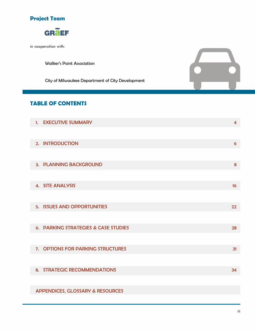
Project Team
in cooperation with:
Walker’s Point Association
City of Milwaukee Department of City Development
TABLE OF CONTENTS
1. EXECUTIVE SUMMARY
2. INTRODUCTION
3. PLANNING BACKGROUND
4. SITE ANALYSIS
5. ISSUES AND OPPORTUNITIES
6. PARKING STRATEGIES & CASE STUDIES
7. OPTIONS FOR PARKING STRUCTURES
8. STRATEGIC RECOMMENDATIONS
APPENDICES, GLOSSARY & RESOURCES
4
6
8
16
22
28
31
34
4 Walker’s Point Parking Study
1. EXECUTIVE SUMMARY
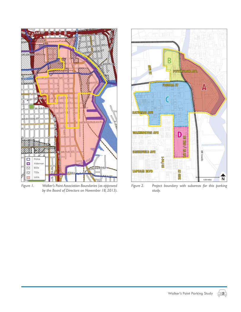
This parking study was commissioned by a private/public effort between the Walker’s Point Association (WPA) and the City of Milwaukee. The study boundary for this report primarily focuses on commercial, industrial, institutional and multi-family areas of Walker’s Point (see fi gures 1 and 2). Both on- and off-street parking facilities were examined as part of this study.
Recommendations came from a combined analysis of past plan review (as listed in Chapter 3), existing site conditions (high number of underutilized off-street parking lots, lack of on-street parking restrictions), relevant case studies and parking strategies (shared parking, valet parking, smart parking), and input from public and private stakeholders.
Four parking themes or recommendations are presented within this study:
1. Emphasize shared parkingIn the short-term, perceived parking supply shortages can be solved by the increased usage effi ciency of existing off-street parking lots. Specifi cally, every existing parking lot and individual space should be studied to determine the opportunities for shared parking and 24/7 occupancy.
2. Reduce unrestricted, on-street parking coupled with off-street parking solutionsTo ensure long-term success of off-street parking, recommendations for shared parking and increased on-street parking restrictions (i.e. parking meters, parking time limits) need to occur (particularly in commercial areas).
3. Support integrated parking structures before freestanding parking structuresIntegrated parking structures not only serve new, expected users (like a new apartment building or offi ce) – they also provide additional spaces that serve neighborhood activity generated by a larger, general population of users. Based upon existing supply and demand, the creation of an integrated parking structure should occur within the northeast area of Walker’s Point (subarea A, as seen in the map on the right).
4. Balance parking to fi t the needs of the larger districtParking solutions need to support the strong mix of land uses within Walker’s Point by a) eliminating assigned, off-street spaces, b) pricing on-street parking appropriately (e.g. daytime/nighttime rates, dynamic pricing) and c) incentivizing alternative transportation modes.
5Walker’s Point Parking Study
N0.25 miles
RR tracks
Figure 1. Walker’s Point Association Boundaries (as approved by the Board of Directors on November 18, 2013).
Figure 2. Project boundary with subareas for this parking study.
6 Walker’s Point Parking Study
Walker’s Point has historically been known as a neighborhood located at the center of activity. From its early beginnings as one of Milwaukee’s fi rst three settlements, it was positioned at the confl uence of the Milwaukee, Menomonee and Kinnickinnic rivers and was host to a strong industrial base complemented by residential and entertainment uses. Fast forward to today, and Walker’s Point continues to be a center of activity, and is considered a truly unique “LIVE. WORK. PLAY.” neighborhood. However,
“You cannot live, work, and play anywhere unless you can get there.”
In many higher-density communities, the above statement is self-evident and far from problematic. In cities like Milwaukee, however, which are less dense and rely heavily on an auto-oriented urban pattern, “getting there” remains a complex issue.
Effective urban circulation in Walker’s Point depends on maximizing the use of existing parking. For typical shopping malls, stand-alone offi ces, and comparable facilities, there are many occasions during the day/week when large parking areas remain vacant. In contrast, Walker’s Point represents a high-quality, urban mixed-use district in which parking space occupancy needs to be maximized, and a confl ict among users must be minimized.
Maximizing the use of parking also requires lowering the demand – not by decreasing development, but by increasing circulation via walking, bicycling, transit, and, inevitably, parking occupancy. As indicated throughout this study, the community-wide economic value of a
2. INTRODUCTION
parking space goes up when the demand for parking can be reduced through increased non-automobile circulation. For decades, parking issues have pervaded almost all discussions of urban value. The primary problem is not the total supply of parking, but the distribution and patterns of use and occupancy. Walker’s Point needs several types of improvements including: clear signage for new visitors and customers, policies that discourage inappropriate use of retail/restaurant parking (e.g. reserved stalls that remain empty, or non-customers parking all day in front of business), support for new residential and offi ce parking, and community-based management policies that accommodate the varying use patterns for different seasons/events, times of the day, and days of the week.
Movement of pedestrians, vehicles, and cyclists should be balanced and integrated (see fi gure 3). Improving multi-modal circulation requires changes in streetscape and street design, a topic already in discussion as part of the Walker’s Point Strategic Action Plan.
Assuming, however, that strategies are in place for maximizing the use of current parking, there will still be a need for more spaces – in some cases surface lots and street parking, and in other cases, indoor private parking facilities and public/private parking structures.
The intent of this report is to provide the Walker’s Point Association with a neighborhood-wide parking strategy and tools to work collaboratively with businesses, residents, and the City of Milwaukee to implement parking solutions that will continue the growth of Walker’s Point as a “LIVE. WORK. PLAY.” neighborhood.
7Walker’s Point Parking Study
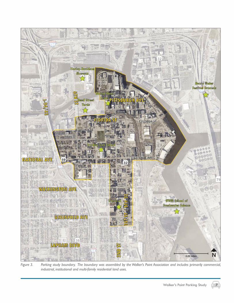
Figure 3. Parking study boundary. The boundary was assembled by the Walker’s Point Association and includes primarily commercial, industrial, institutional and multi-family residential land uses.
N0.25 miles
8 Walker’s Point Parking Study
3. PLANNING BACKGROUND
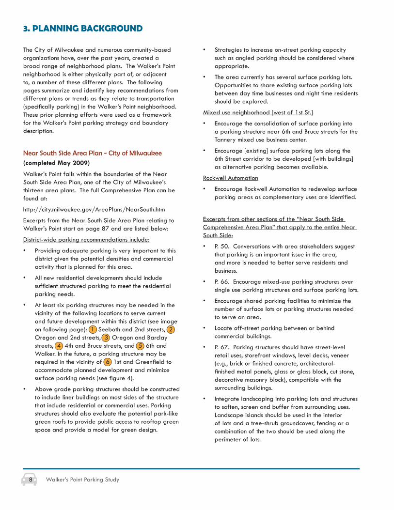
The City of Milwaukee and numerous community-based organizations have, over the past years, created a broad range of neighborhood plans. The Walker’s Point neighborhood is either physically part of, or adjacent to, a number of these different plans. The following pages summarize and identify key recommendations from different plans or trends as they relate to transportation (specifi cally parking) in the Walker’s Point neighborhood. These prior planning efforts were used as a framework for the Walker’s Point parking strategy and boundary description.
Near South Side Area Plan - City of Milwaukee(completed May 2009)
Walker’s Point falls within the boundaries of the Near South Side Area Plan, one of the City of Milwaukee’s thirteen area plans. The full Comprehensive Plan can be found at:
http://city.milwaukee.gov/AreaPlans/NearSouth.htm
Excerpts from the Near South Side Area Plan relating to Walker’s Point start on page 87 and are listed below:
District-wide parking recommendations include:
• Providing adequate parking is very important to this district given the potential densities and commercial activity that is planned for this area.
• All new residential developments should include suffi cient structured parking to meet the residential parking needs.
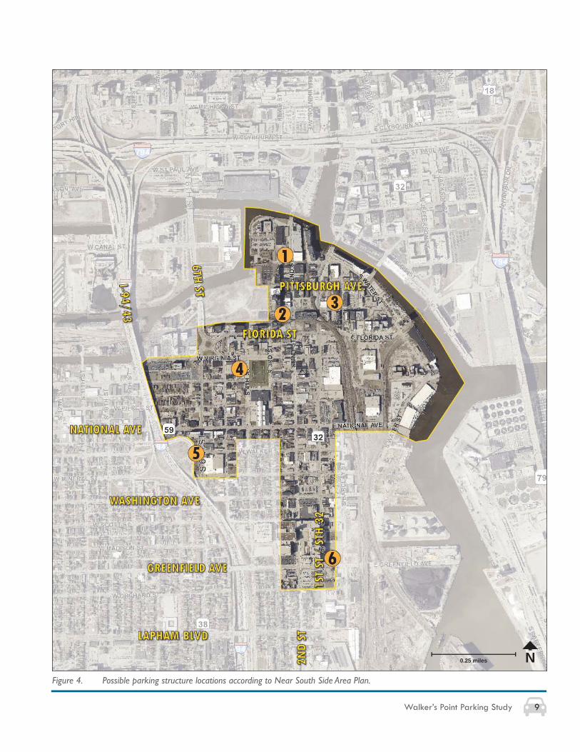
• At least six parking structures may be needed in the vicinity of the following locations to serve current and future development within this district (see image on following page): 1 Seeboth and 2nd streets, 2 Oregon and 2nd streets, 3 Oregon and Barclay streets, 4 4th and Bruce streets, and 5 6th and Walker. In the future, a parking structure may be required in the vicinity of 6 1st and Greenfi eld to accommodate planned development and minimize surface parking needs (see fi gure 4).
• Above grade parking structures should be constructed to include liner buildings on most sides of the structure that include residential or commercial uses. Parking structures should also evaluate the potential park-like green roofs to provide public access to rooftop green space and provide a model for green design.
• Strategies to increase on-street parking capacity such as angled parking should be considered where appropriate.
• The area currently has several surface parking lots. Opportunities to share existing surface parking lots between day time businesses and night time residents should be explored.
Mixed use neighborhood [west of 1st St.]
• Encourage the consolidation of surface parking into a parking structure near 6th and Bruce streets for the Tannery mixed use business center.
• Encourage [existing] surface parking lots along the 6th Street corridor to be developed [with buildings] as alternative parking becomes available.
Rockwell Automation
• Encourage Rockwell Automation to redevelop surface parking areas as complementary uses are identifi ed.
Excerpts from other sections of the “Near South Side Comprehensive Area Plan” that apply to the entire Near South Side:
• P. 50. Conversations with area stakeholders suggest that parking is an important issue in the area, and more is needed to better serve residents and business.
• P. 66. Encourage mixed-use parking structures over single use parking structures and surface parking lots.
• Encourage shared parking facilities to minimize the number of surface lots or parking structures needed to serve an area.
• Locate off-street parking between or behind commercial buildings.
• P. 67. Parking structures should have street-level retail uses, storefront windows, level decks, veneer (e.g., brick or fi nished concrete, architectural-fi nished metal panels, glass or glass block, cut stone, decorative masonry block), compatible with the surrounding buildings.
• Integrate landscaping into parking lots and structures to soften, screen and buffer from surrounding uses. Landscape islands should be used in the interior of lots and a tree-shrub groundcover, fencing or a combination of the two should be used along the perimeter of lots.
9Walker’s Point Parking Study
Figure 4. Possible parking structure locations according to Near South Side Area Plan.
N0.25 miles
10 Walker’s Point Parking Study
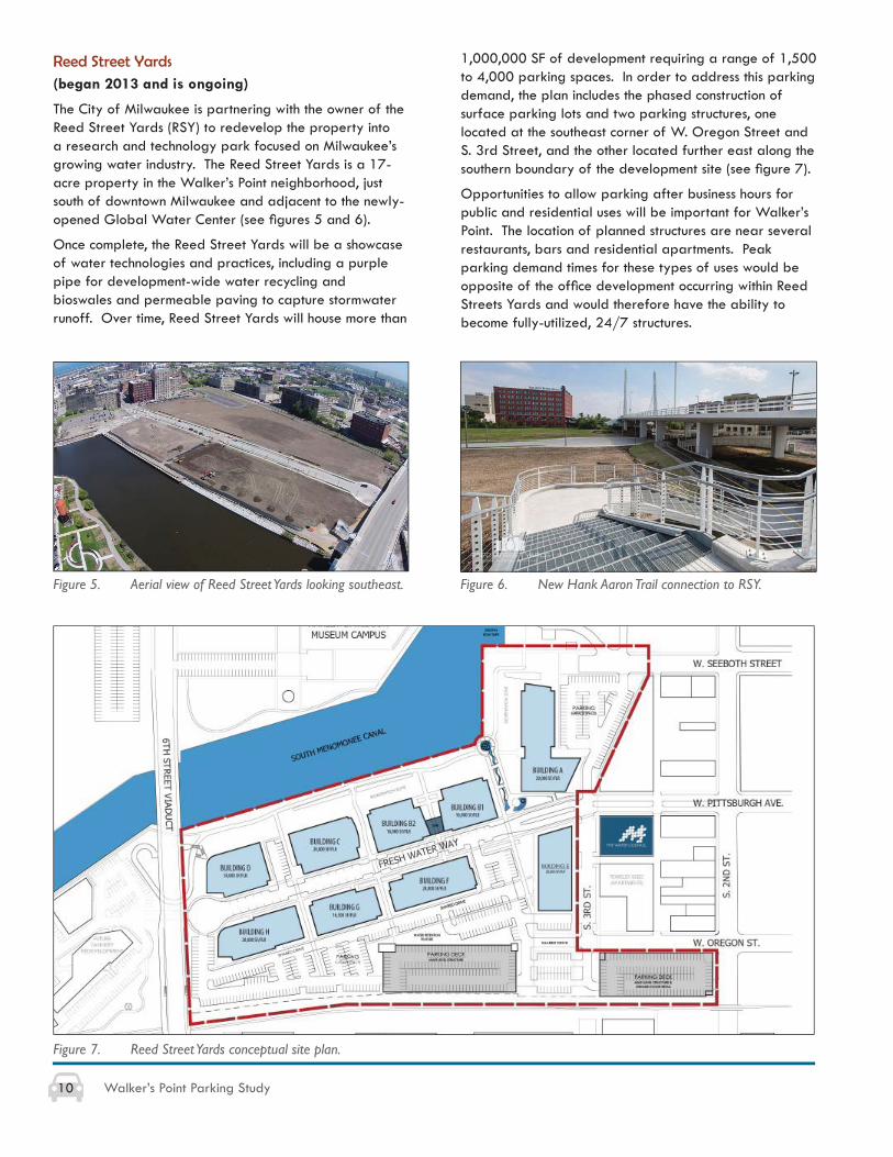
Reed Street Yards(began 2013 and is ongoing)
The City of Milwaukee is partnering with the owner of the Reed Street Yards (RSY) to redevelop the property into a research and technology park focused on Milwaukee’s growing water industry. The Reed Street Yards is a 17-acre property in the Walker’s Point neighborhood, just south of downtown Milwaukee and adjacent to the newly-opened Global Water Center (see fi gures 5 and 6).
Once complete, the Reed Street Yards will be a showcase of water technologies and practices, including a purple pipe for development-wide water recycling and bioswales and permeable paving to capture stormwater runoff. Over time, Reed Street Yards will house more than
1,000,000 SF of development requiring a range of 1,500 to 4,000 parking spaces. In order to address this parking demand, the plan includes the phased construction of surface parking lots and two parking structures, one located at the southeast corner of W. Oregon Street and S. 3rd Street, and the other located further east along the southern boundary of the development site (see fi gure 7).
Opportunities to allow parking after business hours for public and residential uses will be important for Walker’s Point. The location of planned structures are near several restaurants, bars and residential apartments. Peak parking demand times for these types of uses would be opposite of the offi ce development occurring within Reed Streets Yards and would therefore have the ability to become fully-utilized, 24/7 structures.
Figure 5. Aerial view of Reed Street Yards looking southeast. Figure 6. New Hank Aaron Trail connection to RSY.
Figure 7. Reed Street Yards conceptual site plan.
11Walker’s Point Parking Study
Walker’s Point Strategic Action Plan(to be completed in 2014)
Walker’s Point Association is currently working with the City of Milwaukee on a Strategic Action Plan for the entire Walker’s Point neighborhood. This plan will incorporate strategies to continue positive, high-quality development in Walker’s Point.
Inner Harbor Redevelopment Projects
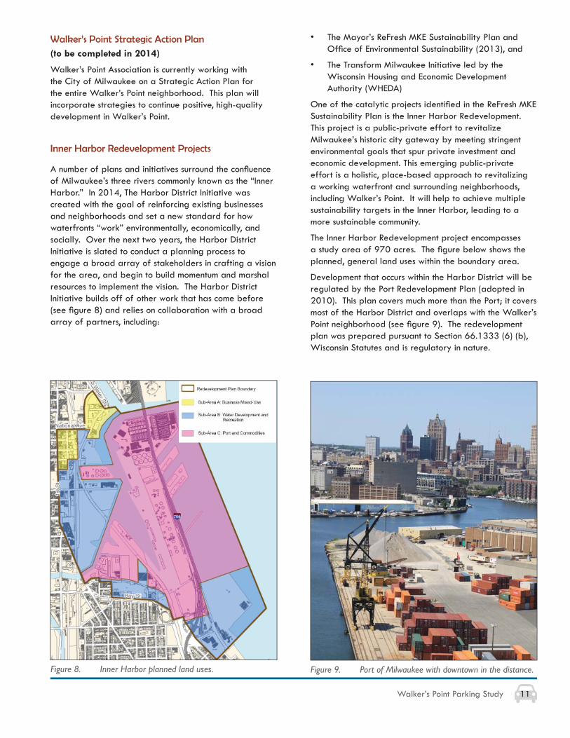
A number of plans and initiatives surround the confl uence of Milwaukee’s three rivers commonly known as the “Inner Harbor.” In 2014, The Harbor District Initiative was created with the goal of reinforcing existing businesses and neighborhoods and set a new standard for how waterfronts “work” environmentally, economically, and socially. Over the next two years, the Harbor District Initiative is slated to conduct a planning process to engage a broad array of stakeholders in crafting a vision for the area, and begin to build momentum and marshal resources to implement the vision. The Harbor District Initiative builds off of other work that has come before (see fi gure 8) and relies on collaboration with a broad array of partners, including:
• The Mayor’s ReFresh MKE Sustainability Plan and Offi ce of Environmental Sustainability (2013), and
• The Transform Milwaukee Initiative led by the Wisconsin Housing and Economic Development Authority (WHEDA)
One of the catalytic projects identifi ed in the ReFresh MKE Sustainability Plan is the Inner Harbor Redevelopment. This project is a public-private effort to revitalize Milwaukee’s historic city gateway by meeting stringent environmental goals that spur private investment and economic development. This emerging public-private effort is a holistic, place-based approach to revitalizing a working waterfront and surrounding neighborhoods, including Walker’s Point. It will help to achieve multiple sustainability targets in the Inner Harbor, leading to a more sustainable community.
The Inner Harbor Redevelopment project encompasses a study area of 970 acres. The fi gure below shows the planned, general land uses within the boundary area.
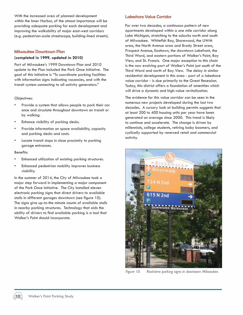
Development that occurs within the Harbor District will be regulated by the Port Redevelopment Plan (adopted in 2010). This plan covers much more than the Port; it covers most of the Harbor District and overlaps with the Walker’s Point neighborhood (see fi gure 9). The redevelopment plan was prepared pursuant to Section 66.1333 (6) (b), Wisconsin Statutes and is regulatory in nature.
Figure 8. Inner Harbor planned land uses. Figure 9. Port of Milwaukee with downtown in the distance.
12 Walker’s Point Parking Study
With the increased area of planned development within the Inner Harbor, of the utmost importance will be providing adequate parking for each development and improving the walkability of major east-west corridors (e.g. pedestrian-scale streetscape, building-lined streets).
Milwaukee Downtown Plan(completed in 1999, updated in 2010)
Part of Milwaukee’s 1999 Downtown Plan and 2010 update to the Plan included the Park Once Initiative. The goal of this initiative is “To coordinate parking facilities with information signs indicating vacancies, and with the transit system connecting to all activity generators.”
Objectives:
• Provide a system that allows people to park their car once and circulate throughout downtown on transit or by walking.
• Enhance visibility of parking decks.
• Provide information on space availability, capacity and parking decks and costs.
• Locate transit stops in close proximity to parking garage entrances.
Benefi ts:
• Enhanced utilization of existing parking structures.
• Enhanced pedestrian mobility improves business viability.
In the summer of 2014, the City of Milwaukee took a major step forward in implementing a major component of the Park Once Initiative. The City installed eleven electronic parking signs that direct drivers to available stalls in different garages downtown (see fi gure 10). The signs give up-to-the minute counts of available stalls in nearby parking structures. Technology that aids the ability of drivers to fi nd available parking is a tool that Walker’s Point should incorporate.
Lakeshore Value Corridor
For over two decades, a continuous pattern of new apartments developed within a one mile corridor along Lake Michigan, stretching to the suburbs north and south of Milwaukee. Whitefi sh Bay, Shorewood, the UWM area, the North Avenue area and Brady Street area, Prospect Avenue, Easttown, the downtown Lakefront, the Third Ward, and eastern portions of Walker’s Point, Bay View, and St. Francis. One major exception to this chain is the now evolving part of Walker’s Point just south of the Third Ward and north of Bay View. The delay in similar residential development in this area - part of a lakeshore value corridor - is due primarily to the Great Recession. Today, this district offers a foundation of amenities which will drive a dynamic and high-value revitalization.
The evidence for this value corridor can be seen in the numerous new projects developed during the last two decades. A cursory look at building permits suggests that at least 200 to 400 housing units per year have been generated on average since 2000. This trend is likely to continue and accelerate. The change is driven by millennials, college students, retiring baby boomers, and cyclically supported by renewed retail and commercial activity.
Figure 10. Real-time parking signs in downtown Milwaukee.
13Walker’s Point Parking Study
Figure 11. Bublr bike sharing station located in downtown Milwaukee.
Alternative Transportation Plans
Bicycle Trends
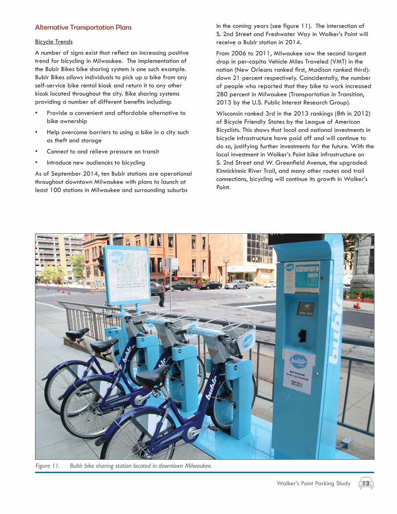
A number of signs exist that refl ect an increasing positive trend for bicycling in Milwaukee. The implementation of the Bublr Bikes bike sharing system is one such example. Bublr Bikes allows individuals to pick up a bike from any self-service bike rental kiosk and return it to any other kiosk located throughout the city. Bike sharing systems providing a number of different benefi ts including:
• Provide a convenient and affordable alternative to bike ownership
• Help overcome barriers to using a bike in a city such as theft and storage
• Connect to and relieve pressure on transit
• Introduce new audiences to bicycling
As of September 2014, ten Bublr stations are operational throughout downtown Milwaukee with plans to launch at least 100 stations in Milwaukee and surrounding suburbs
in the coming years (see fi gure 11). The intersection of S. 2nd Street and Freshwater Way in Walker’s Point will receive a Bublr station in 2014.
From 2006 to 2011, Milwaukee saw the second largest drop in per-capita Vehicle Miles Traveled (VMT) in the nation (New Orleans ranked fi rst, Madison ranked third): down 21 percent respectively. Coincidentally, the number of people who reported that they bike to work increased 280 percent in Milwaukee (Transportation in Transition, 2013 by the U.S. Public Interest Research Group).
Wisconsin ranked 3rd in the 2013 rankings (8th in 2012) of Bicycle Friendly States by the League of American Bicyclists. This shows that local and national investments in bicycle infrastructure have paid off and will continue to do so, justifying further investments for the future. With the local investment in Walker’s Point bike infrastructure on S. 2nd Street and W. Greenfi eld Avenue, the upgraded Kinnickinnic River Trail, and many other routes and trail connections, bicycling will continue its growth in Walker’s Point.
14 Walker’s Point Parking Study
Milwaukee Streetcar
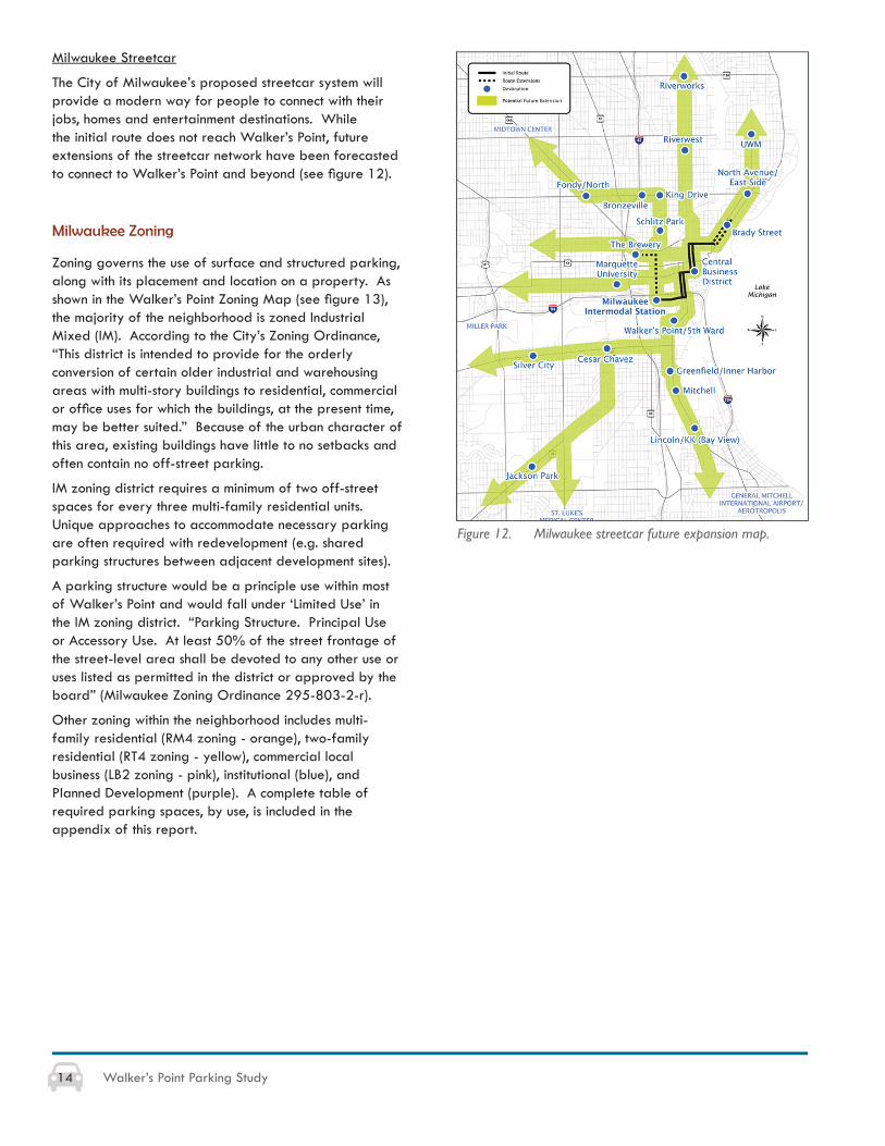
The City of Milwaukee’s proposed streetcar system will provide a modern way for people to connect with their jobs, homes and entertainment destinations. While the initial route does not reach Walker’s Point, future extensions of the streetcar network have been forecasted to connect to Walker’s Point and beyond (see fi gure 12).
Milwaukee Zoning
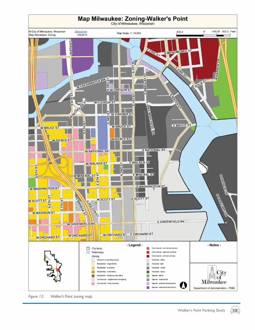
Zoning governs the use of surface and structured parking, along with its placement and location on a property. As shown in the Walker’s Point Zoning Map (see fi gure 13), the majority of the neighborhood is zoned Industrial Mixed (IM). According to the City’s Zoning Ordinance, “This district is intended to provide for the orderly conversion of certain older industrial and warehousing areas with multi-story buildings to residential, commercial or offi ce uses for which the buildings, at the present time, may be better suited.” Because of the urban character of this area, existing buildings have little to no setbacks and often contain no off-street parking.
IM zoning district requires a minimum of two off-street spaces for every three multi-family residential units. Unique approaches to accommodate necessary parking are often required with redevelopment (e.g. shared parking structures between adjacent development sites).
A parking structure would be a principle use within most of Walker’s Point and would fall under ‘Limited Use’ in the IM zoning district. “Parking Structure. Principal Use or Accessory Use. At least 50% of the street frontage of the street-level area shall be devoted to any other use or uses listed as permitted in the district or approved by the board” (Milwaukee Zoning Ordinance 295-803-2-r).
Other zoning within the neighborhood includes multi-family residential (RM4 zoning - orange), two-family residential (RT4 zoning - yellow), commercial local business (LB2 zoning - pink), institutional (blue), and Planned Development (purple). A complete table of required parking spaces, by use, is included in the appendix of this report.
Figure 12. Milwaukee streetcar future expansion map.
15Walker’s Point Parking Study
Figure 13. Walker’s Point zoning map.

16 Walker’s Point Parking Study
4. SITE ANALYSIS
Parking Regulations
On-street
A large number of streets within Walker’s Point have no parking restrictions with regard to the length of time one can park in a certain space. While the idea of free, unlimited parking sounds attractive to most, the problems that result from this lack of regulation are signifi cant.
One observation of this occurrence in Walker’s Point: students from MIAD will park all day (6-10 hours) on S. Barclay and E. Oregon streets due to the fact that no on-street restrictions are posted. While this is attractive for students, employees and customers in this same region are unable to fi nd nearby parking within close proximity.
Another example is S. 3rd Street adjacent to Lynde and Harry Bradley Technology and Trade School (Bradley Tech). Although a designated parking lot exists one block away from the school (SW corner of S. 4th Street and W. Virginia Street), school staff members park along S. 3rd Street all day because no signed restrictions exist. This eliminates the ability for single- and two-family home owners across the street to park in front of their homes.
The majority of on-street parking restrictions that can be seen in Walker’s Point are the 2-hour, unmetered parking from 7AM-7PM. While this type of restriction allows for turnover within this time period (ideal for certain retail/food/drink customers), it is not ideal for employees who work an 8-hour shift and need to continually move their vehicles. Another issue caused by the unmetered parking is seen during event days (e.g. Brewers games, Summerfest). Several bars have shuttle buses that take people from their Walker’s Point location to the destination outside of Walker’s Point. People park their vehicles on the street shortly after 5pm (peak restaurant hours) and leave them until late evening. This occurrence leaves little to no parking for other restaurant patrons looking to dine at nearby locations.
Introducing metered parking to key areas of Walker’s Point is a strategy that should be closely examined by the WPA. The LUKE meters administered in the downtown area by the City of Milwaukee could naturally be implemented in certain areas of Walker’s Point.
Other parking regulations that existing in Walker’s Point include the following:
• 1-hour metered parking (found on S. 6th Street north of W. National Avenue)
• 2-hour metered parking (found on S. 5th Street between W. Bruce Street and W. Walker Street)
• Variety of metered parking along W. National Avenue
• No stopping 6:30am-8:30am along northern portions of S. 1st Street
• No parking anytime on streets surrounding Rockwell Automation (e.g. S. 1st Street, S. 2nd Street, and S. 3rd Street)
Streets that do utilize metered parking only have a fi xed-rate system, charging the same amount per stall no matter what the time of day or how great the nearby occupancy. Implementing a dynamic pricing system should be examined for all existing metered streets. This parking strategy applies different rates to specifi c blocks in an effort to infl uence traveler mode choice, time and amount of travel, and shift drivers from a congested location.
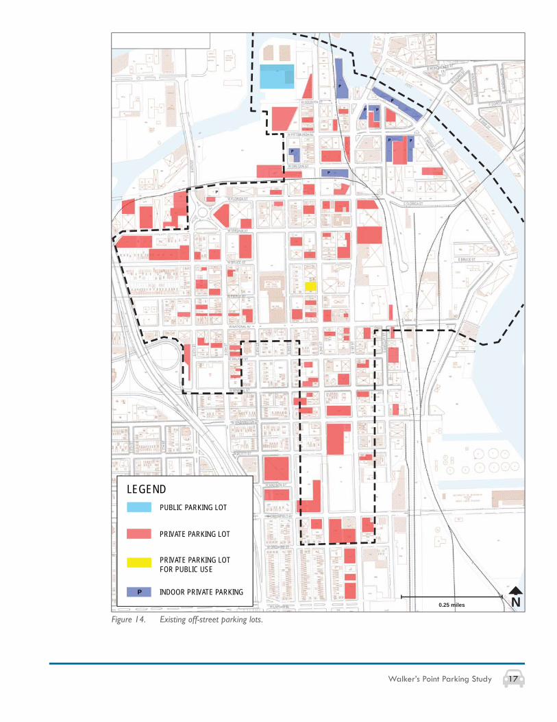
Off-street
While a large number of private, off-street parking lots exist within Walker’s Point (see fi gure 14), the majority are restricted to single-property owners and do not allow for public parking or shared uses. Additionally, many of these lots include assigned or reserved spaces that allow only one user per stall. This condition produces parking stalls and lots that sit empty for over half of the day and offer mediocre economic outcomes. A potential reason that shared parking lots do not currently exist is because of the readily available, free street parking throughout Walker’s Point. As long as free, on-street parking remains in Walker’s Point, off-street parking lots that charge even a small parking fee will not be economically feasible.
Valet Parking
In an effort to attract customers and reduce customer need to search for parking, a small number of restaurants within Walker’s Point utilize a valet parking service. The existing valet services have either written or verbal agreements with other private property owners with parking lots. A public meeting hosted by WPA in August 2014 invited bar and restaurant owners to voice parking concerns for the area. A number of owners were interested in the idea of a ‘neighborhood’ valet service that would be available to multiple restaurants who opted into the valet service. This kind of service should be further explored, as it could set apart Walker’s Point and offer a more effi cient system for businesses and patrons alike.
17Walker’s Point Parking Study
Figure 14. Existing off-street parking lots.
N0.25 miles
LEGEND
PRIVATE PARKING LOT
INDOOR PRIVATE PARKINGP
PRIVATE PARKING LOT FOR PUBLIC USE
PUBLIC PARKING LOT

18 Walker’s Point Parking Study
Figure 15. Kinnickinnic River Trail.
80
54
19
17
100
1400
S. 1st
E. Lincoln
S. 11th
S. 6th
S. Cha
S. 2nd
d Lak
e
S. 16th
Maple
Emmbe
r
Bay St
Bicycle and Bus Network
Walker’s Point has seen a number of different bike infrastructure improvements over the past decade including S. 2nd Street and W. Greenfi eld Avenue, the upgraded Kinnickinnic River Trail (see fi gure 15), and the many other routes and trail connections. This bicycle network plays an important role in reducing the demand for automobile parking by providing alternative transportation options for people to reach a Walker’s Point destination. Bicycle facilities in Walker’s Point include:
On-Street
• Bike Lanes – W. Greenfi eld Avenue, S. 2nd Street
• Preferred1 Biking Streets (no lanes) – E./W. Washington Street; S. 6th Street; W. Virginia Street; and S. Water Street
Off Street
• Oak Leaf Trail – Trail travels through Walker’s Point on S. 2nd Street
• Hank Aaron State Trail – Trail connects through Walker’s Point on W. Florida, W. Virginia, S. 6th streets as well as a new 2014 extension through Reed Street Yards (see fi gure 16)
• Kinnickinnic (KK) River Trail – W. Maple Street to E. Washington Street, merging into S. Water Street up to S. 1st Street.
The elements that connect Walker’s Point to other parts of Milwaukee are key to continued local growth. Connections are partially accomplished through the Milwaukee County Transit System (MCTS). Routes include the following (see fi gure 17):
• 15 – Holton-Kinnickinnic – Connects Glendale, Shorewood, Downtown, Third Ward, Walker’s Point, Bay View, St. Francis, Cudahy, and South Milwaukee
• 19 – MLK – S. 13th & S. 20th Streets – Connects Northwest Side, Historic King Drive, Downtown, Walker’s Point, and Greenfi eld
• 23 – Fond du Lac – National – Connects Midtown, Downtown, Walker’s Point, Mitchell Park Domes, Miller Park, and the VA Medical Center
• 80 – 6th Street – Connects Downtown, Walker’s Point, Historic Mitchell Street, Airport, and Oak Creek
• BlueLine – Fond du Lac – National – Connects Park Place, Midtown, Marquette, Downtown, Walker’s Point, Clarke Square, Silver City, Miller Park, VA Medical Center, and West Allis
• GreenLine – Bayshore – Airport – Connects Glendale, Shorewood, University of Wisconsin–Milwaukee, Downtown, Walker’s Point, Bay View, and the Airport
1 ‘Preferred’ refers to roads with wider outside lanes and those streets frequently used by cyclists.
Figure 16. Hank Aaron State trail entering Reed Street Yards.
Figure 17. MCTS bus routes within Walker’s Point.
19Walker’s Point Parking Study
Urban Character
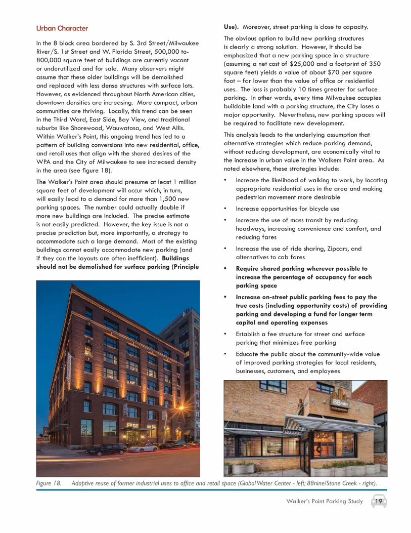
In the 8 block area bordered by S. 3rd Street/Milwaukee River/S. 1st Street and W. Florida Street, 500,000 to-800,000 square feet of buildings are currently vacant or underutilized and for sale. Many observers might assume that these older buildings will be demolished and replaced with less dense structures with surface lots. However, as evidenced throughout North American cities, downtown densities are increasing. More compact, urban communities are thriving. Locally, this trend can be seen in the Third Ward, East Side, Bay View, and traditional suburbs like Shorewood, Wauwatosa, and West Allis. Within Walker’s Point, this ongoing trend has led to a pattern of building conversions into new residential, offi ce, and retail uses that align with the shared desires of the WPA and the City of Milwaukee to see increased density in the area (see fi gure 18).
The Walker’s Point area should presume at least 1 million square feet of development will occur which, in turn, will easily lead to a demand for more than 1,500 new parking spaces. The number could actually double if more new buildings are included. The precise estimate is not easily predicted. However, the key issue is not a precise prediction but, more importantly, a strategy to accommodate such a large demand. Most of the existing buildings cannot easily accommodate new parking (and if they can the layouts are often ineffi cient). Buildings should not be demolished for surface parking (Principle
Use). Moreover, street parking is close to capacity.
The obvious option to build new parking structures is clearly a strong solution. However, it should be emphasized that a new parking space in a structure (assuming a net cost of $25,000 and a footprint of 350 square feet) yields a value of about $70 per square foot – far lower than the value of offi ce or residential uses. The loss is probably 10 times greater for surface parking. In other words, every time Milwaukee occupies buildable land with a parking structure, the City loses a major opportunity. Nevertheless, new parking spaces will be required to facilitate new development.
This analysis leads to the underlying assumption that alternative strategies which reduce parking demand, without reducing development, are economically vital to the increase in urban value in the Walkers Point area. As noted elsewhere, these strategies include:
• Increase the likelihood of walking to work, by locating appropriate residential uses in the area and making pedestrian movement more desirable
• Increase opportunities for bicycle use
• Increase the use of mass transit by reducing headways, increasing convenience and comfort, and reducing fares
• Increase the use of ride sharing, Zipcars, and alternatives to cab fares
• Require shared parking wherever possible to increase the percentage of occupancy for each parking space
• Increase on-street public parking fees to pay the true costs (including opportunity costs) of providing parking and developing a fund for longer term capital and operating expenses
• Establish a fee structure for street and surface parking that minimizes free parking
• Educate the public about the community-wide value of improved parking strategies for local residents, businesses, customers, and employees
Figure 18. Adaptive reuse of former industrial uses to offi ce and retail space (Global Water Center - left; 88nine/Stone Creek - right).
20 Walker’s Point Parking Study
Current Development Projects
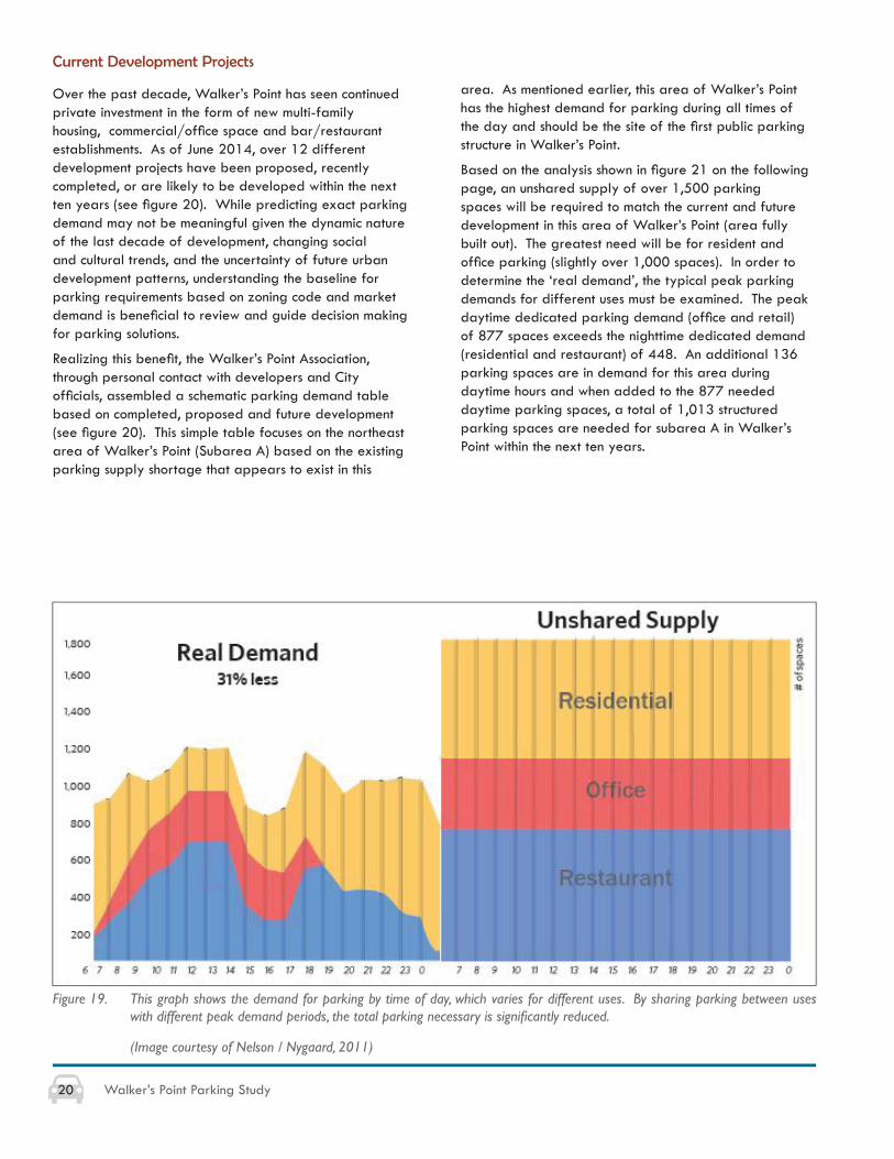
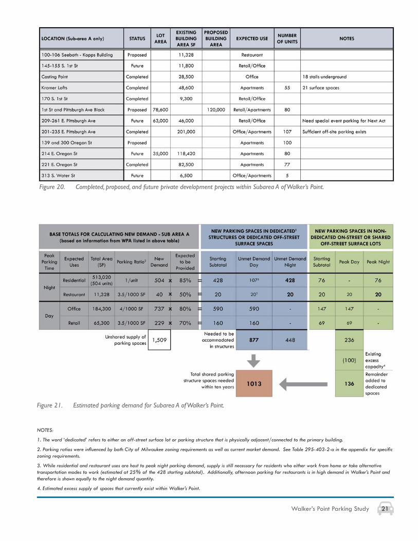
Over the past decade, Walker’s Point has seen continued private investment in the form of new multi-family housing, commercial/offi ce space and bar/restaurant establishments. As of June 2014, over 12 different development projects have been proposed, recently completed, or are likely to be developed within the next ten years (see fi gure 20). While predicting exact parking demand may not be meaningful given the dynamic nature of the last decade of development, changing social and cultural trends, and the uncertainty of future urban development patterns, understanding the baseline for parking requirements based on zoning code and market demand is benefi cial to review and guide decision making for parking solutions.
Realizing this benefi t, the Walker’s Point Association, through personal contact with developers and City offi cials, assembled a schematic parking demand table based on completed, proposed and future development (see fi gure 20). This simple table focuses on the northeast area of Walker’s Point (Subarea A) based on the existing parking supply shortage that appears to exist in this
Figure 19. This graph shows the demand for parking by time of day, which varies for different uses. By sharing parking between uses with different peak demand periods, the total parking necessary is signifi cantly reduced.
(Image courtesy of Nelson / Nygaard, 2011)
area. As mentioned earlier, this area of Walker’s Point has the highest demand for parking during all times of the day and should be the site of the fi rst public parking structure in Walker’s Point.
Based on the analysis shown in fi gure 21 on the following page, an unshared supply of over 1,500 parking spaces will be required to match the current and future development in this area of Walker’s Point (area fully built out). The greatest need will be for resident and offi ce parking (slightly over 1,000 spaces). In order to determine the ‘real demand’, the typical peak parking demands for different uses must be examined. The peak daytime dedicated parking demand (offi ce and retail) of 877 spaces exceeds the nighttime dedicated demand (residential and restaurant) of 448. An additional 136 parking spaces are in demand for this area during daytime hours and when added to the 877 needed daytime parking spaces, a total of 1,013 structured parking spaces are needed for subarea A in Walker’s Point within the next ten years.
21Walker’s Point Parking Study
NOTES:
1. The word ‘dedicated’ refers to either an off-street surface lot or parking structure that is physically adjacent/connected to the primary building.
2. Parking ratios were infl uenced by both City of Milwaukee zoning requirements as well as current market demand. See Table 295-403-2-a in the appendix for specifi c zoning requirements.
3. While residential and restaurant uses are host to peak night parking demand, supply is still necessary for residents who either work from home or take alternative transportation modes to work (estimated at 25% of the 428 starting subtotal). Additionally, afternoon parking for restaurants is in high demand in Walker’s Point and therefore is shown equally to the night demand quantity.
4. Estimated excess supply of spaces that currently exist within Walker’s Point.
Figure 20. Completed, proposed, and future private development projects within Subarea A of Walker’s Point.
Figure 21. Estimated parking demand for Subarea A of Walker’s Point.
x =
x =
x =
x =
22 Walker’s Point Parking Study
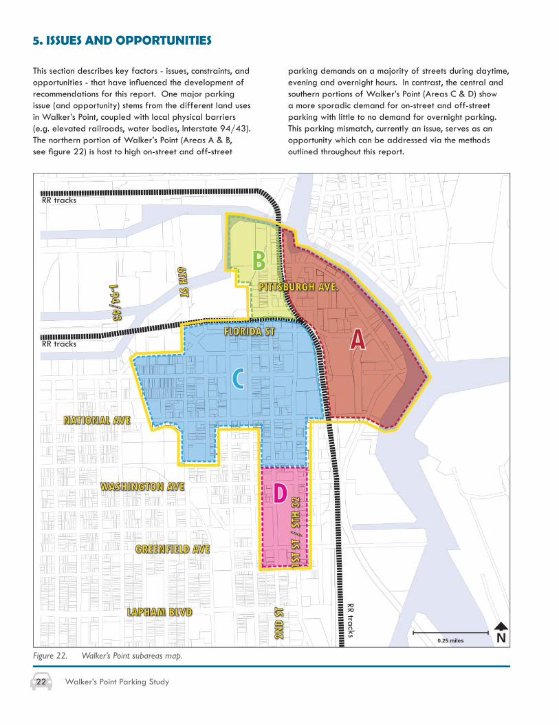
5. ISSUES AND OPPORTUNITIES
This section describes key factors - issues, constraints, and opportunities - that have infl uenced the development of recommendations for this report. One major parking issue (and opportunity) stems from the different land uses in Walker’s Point, coupled with local physical barriers (e.g. elevated railroads, water bodies, Interstate 94/43). The northern portion of Walker’s Point (Areas A & B, see fi gure 22) is host to high on-street and off-street
parking demands on a majority of streets during daytime, evening and overnight hours. In contrast, the central and southern portions of Walker’s Point (Areas C & D) show a more sporadic demand for on-street and off-street parking with little to no demand for overnight parking. This parking mismatch, currently an issue, serves as an opportunity which can be addressed via the methods outlined throughout this report.
Figure 22. Walker’s Point subareas map.
N0.25 miles
RR tracks
RR tracks
RR tracks
23Walker’s Point Parking Study
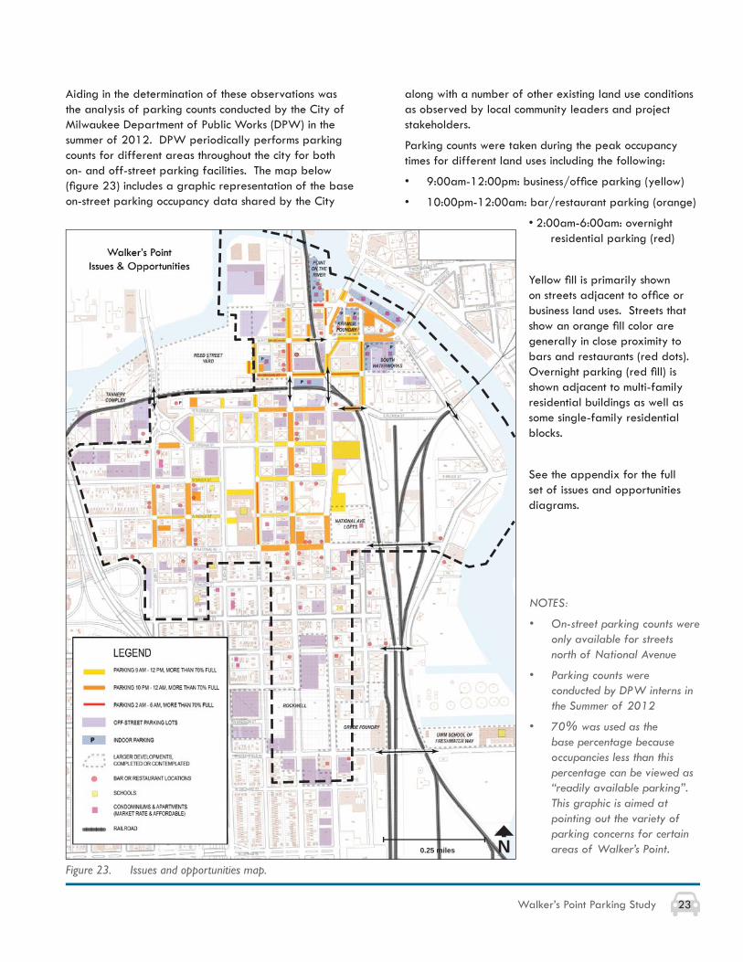
Figure 23. Issues and opportunities map.
NOTES:
• On-street parking counts were only available for streets north of National Avenue
• Parking counts were conducted by DPW interns in the Summer of 2012
• 70% was used as the base percentage because occupancies less than this percentage can be viewed as “readily available parking”. This graphic is aimed at pointing out the variety of parking concerns for certain areas of Walker’s Point.
along with a number of other existing land use conditions as observed by local community leaders and project stakeholders.
Parking counts were taken during the peak occupancy times for different land uses including the following:
• 9:00am-12:00pm: business/offi ce parking (yellow)
• 10:00pm-12:00am: bar/restaurant parking (orange)
• 2:00am-6:00am: overnight residential parking (red)
Yellow fi ll is primarily shown on streets adjacent to offi ce or business land uses. Streets that show an orange fi ll color are generally in close proximity to bars and restaurants (red dots). Overnight parking (red fi ll) is shown adjacent to multi-family residential buildings as well as some single-family residential blocks.
See the appendix for the full set of issues and opportunities diagrams.
N0.25 miles
Aiding in the determination of these observations was the analysis of parking counts conducted by the City of Milwaukee Department of Public Works (DPW) in the summer of 2012. DPW periodically performs parking counts for different areas throughout the city for both on- and off-street parking facilities. The map below (fi gure 23) includes a graphic representation of the base on-street parking occupancy data shared by the City
24 Walker’s Point Parking Study
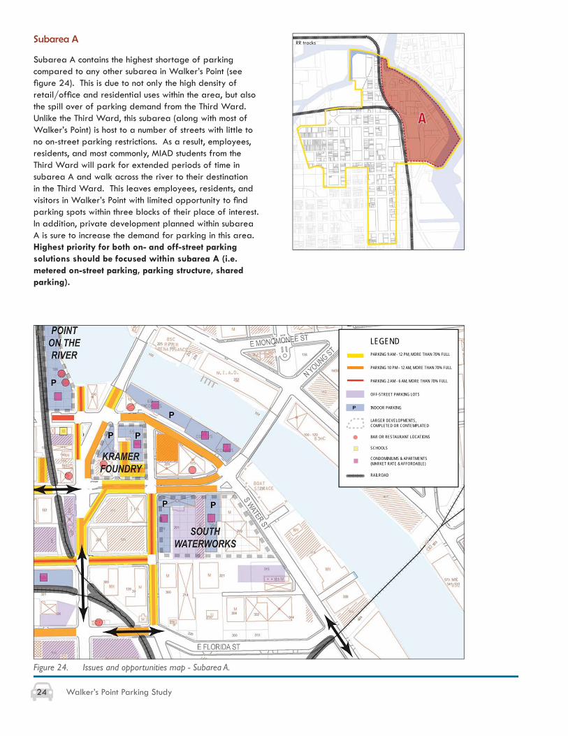
Subarea A
Subarea A contains the highest shortage of parking compared to any other subarea in Walker’s Point (see fi gure 24). This is due to not only the high density of retail/offi ce and residential uses within the area, but also the spill over of parking demand from the Third Ward. Unlike the Third Ward, this subarea (along with most of Walker’s Point) is host to a number of streets with little to no on-street parking restrictions. As a result, employees, residents, and most commonly, MIAD students from the Third Ward will park for extended periods of time in subarea A and walk across the river to their destination in the Third Ward. This leaves employees, residents, and visitors in Walker’s Point with limited opportunity to fi nd parking spots within three blocks of their place of interest. In addition, private development planned within subarea A is sure to increase the demand for parking in this area. Highest priority for both on- and off-street parking solutions should be focused within subarea A (i.e. metered on-street parking, parking structure, shared parking).
Figure 24. Issues and opportunities map - Subarea A.
LEGENDPARKING 9 AM - 12 PM, MORE THAN 70% FULL
PARKING 10 PM - 12 AM, MORE THAN 70% FULL
PARKING 2 AM - 6 AM, MORE THAN 70% FULL
OFF-STREET PARKING LOTS
INDOOR PARKING
BAR OR RESTAURANT LOCATIONS
SCHOOLS
CONDOMINIUMS & APARTMENTS (MARKET RATE & AFFORDABLE)
RAILROAD
LARGER DEVELOPMENTS, COMPLETED OR CONTEMPLATED
P
RR tracks
25Walker’s Point Parking Study
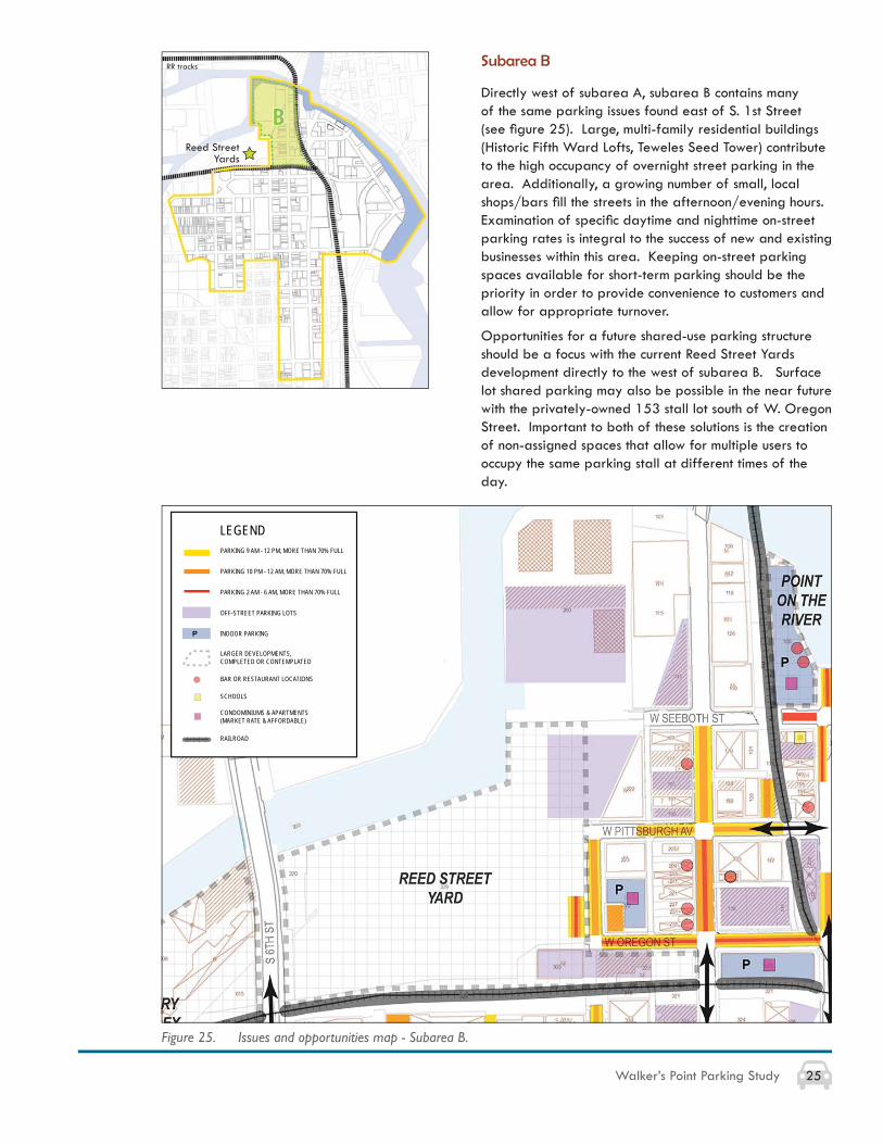
Subarea B
Directly west of subarea A, subarea B contains many of the same parking issues found east of S. 1st Street (see fi gure 25). Large, multi-family residential buildings (Historic Fifth Ward Lofts, Teweles Seed Tower) contribute to the high occupancy of overnight street parking in the area. Additionally, a growing number of small, local shops/bars fi ll the streets in the afternoon/evening hours. Examination of specifi c daytime and nighttime on-street parking rates is integral to the success of new and existing businesses within this area. Keeping on-street parking spaces available for short-term parking should be the priority in order to provide convenience to customers and allow for appropriate turnover.
Opportunities for a future shared-use parking structure should be a focus with the current Reed Street Yards development directly to the west of subarea B. Surface lot shared parking may also be possible in the near future with the privately-owned 153 stall lot south of W. Oregon Street. Important to both of these solutions is the creation of non-assigned spaces that allow for multiple users to occupy the same parking stall at different times of the day.
Figure 25. Issues and opportunities map - Subarea B.
LEGENDPARKING 9 AM - 12 PM, MORE THAN 70% FULL
PARKING 10 PM - 12 AM, MORE THAN 70% FULL
PARKING 2 AM - 6 AM, MORE THAN 70% FULL
OFF-STREET PARKING LOTS
INDOOR PARKING
BAR OR RESTAURANT LOCATIONS
SCHOOLS
CONDOMINIUMS & APARTMENTS (MARKET RATE & AFFORDABLE)
RAILROAD
LARGER DEVELOPMENTS, COMPLETED OR CONTEMPLATED
P
Reed Street Yards
RR tracks
26 Walker’s Point Parking Study
Figure 26. Issues and opportunities map - Subarea C.
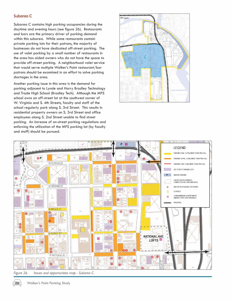
Subarea C
Subarea C contains high parking occupancies during the daytime and evening hours (see fi gure 26). Restaurants and bars are the primary driver of parking demand within this subarea. While some restaurants contain private parking lots for their patrons, the majority of businesses do not have dedicated off-street parking. The use of valet parking by a small number of restaurants in the area has aided owners who do not have the space to provide off-street parking. A neighborhood valet service that would serve multiple Walker’s Point restaurant/bar patrons should be examined in an effort to solve parking shortages in the area.
Another parking issue in this area is the demand for parking adjacent to Lynde and Harry Bradley Technology and Trade High School (Bradley Tech). Although the MPS school owns an off-street lot at the southwest corner of W. Virginia and S. 4th Streets, faculty and staff of the school regularly park along S. 3rd Street. This results in residential property owners on S. 3rd Street and offi ce employees along S. 2nd Street unable to fi nd street parking. An increase of on-street parking regulations and enforcing the utilization of the MPS parking lot (by faculty and staff) should be pursued.
LEGENDPARKING 9 AM - 12 PM, MORE THAN 70% FULL
PARKING 10 PM - 12 AM, MORE THAN 70% FULL
PARKING 2 AM - 6 AM, MORE THAN 70% FULL
OFF-STREET PARKING LOTS
INDOOR PARKING
BAR OR RESTAURANT LOCATIONS
SCHOOLS
CONDOMINIUMS & APARTMENTS (MARKET RATE & AFFORDABLE)
RAILROAD
LARGER DEVELOPMENTS, COMPLETED OR CONTEMPLATED
P
RR tracks
27Walker’s Point Parking Study
Subarea D
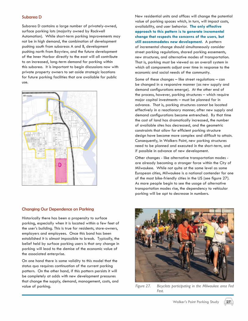
Subarea D contains a large number of privately-owned, surface parking lots (majority owned by Rockwell Automation). While short-term parking improvements may not be in high demand, the combination of development pushing south from subareas A and B, development pushing north from Bayview, and the future development of the Inner Harbor directly to the east will all contribute to an increased, long-term demand for parking within this subarea. It is important to begin discussions now with private property owners to set aside strategic locations for future parking facilities that are available for public use.
New residential units and offi ces will change the potential value of parking spaces which, in turn, will impact costs, availability, and user behavior. The only effective approach to this pattern is to generate incremental change that respects the concerns of the users, but still accommodates new development. A pattern of incremental change should simultaneously consider street parking regulations, shared parking easements, new structures, and alternative modes of transportation. That is, parking must be viewed as an overall system in which all components adjust over time in response to the economic and social needs of the community.
Some of these changes – like street regulations – can be changed in a responsive manner (as new supply and demand confi gurations emerge). At the other end of the process, however, parking structures – which require major capital investments – must be planned far in advance. That is, parking structures cannot be located effectively in a reactionary manner, after new supply and demand confi gurations become entrenched. By that time the cost of land has dramatically increased, the number of available sites has decreased, and the geometric constraints that allow for effi cient parking structure design have become more complex and diffi cult to attain. Consequently, in Walkers Point, new parking structures need to be planned and executed in the short-term, and if possible in advance of new development.
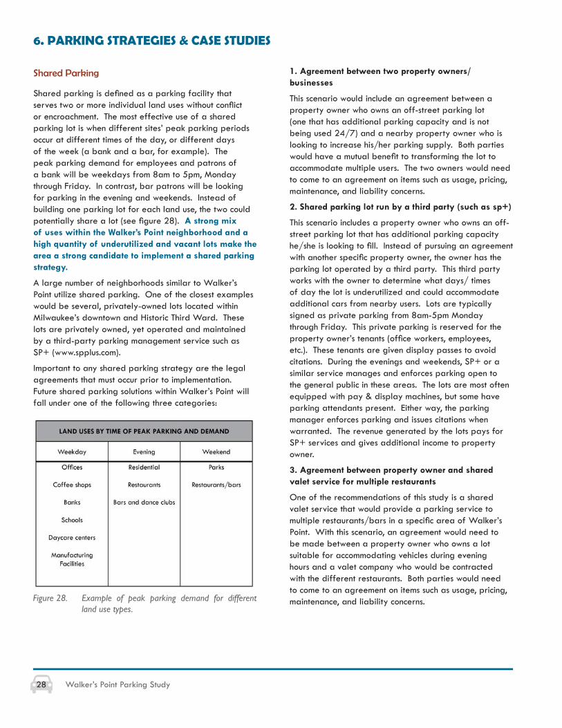
Other changes - like alternative transportation modes - are already becoming a stronger force within the City of Milwaukee. While not quite at the same level as some European cities, Milwaukee is a national contender for one of the most bike-friendly cities in the US (see fi gure 27). As more people begin to see the usage of alternative transportation modes rise, the dependency to vehicular parking will be apt to decrease in numbers.
Changing Our Dependence on Parking
Historically there has been a propensity to surface parking, especially when it is located within a few feet of the user’s building. This is true for residents, store-owners, employers and employees. Once this bond has been established it is almost impossible to break. Typically, the belief held by surface parking users is that any change in parking will lead to the demise of the economic value of the associated enterprise.
On one hand there is some validity to this model that the status quo requires continuation of the current parking pattern. On the other hand, if this pattern persists it will be completely at odds with new development pressures that change the supply, demand, management, costs, and value of parking. Figure 27. Bicyclists participating in the Milwaukee area Fed
Fest.
RR tracks
28 Walker’s Point Parking Study
6. PARKING STRATEGIES & CASE STUDIES
Shared Parking
Shared parking is defi ned as a parking facility that serves two or more individual land uses without confl ict or encroachment. The most effective use of a shared parking lot is when different sites’ peak parking periods occur at different times of the day, or different days of the week (a bank and a bar, for example). The peak parking demand for employees and patrons of a bank will be weekdays from 8am to 5pm, Monday through Friday. In contrast, bar patrons will be looking for parking in the evening and weekends. Instead of building one parking lot for each land use, the two could potentially share a lot (see fi gure 28). A strong mix of uses within the Walker’s Point neighborhood and a high quantity of underutilized and vacant lots make the area a strong candidate to implement a shared parking strategy.
A large number of neighborhoods similar to Walker’s Point utilize shared parking. One of the closest examples would be several, privately-owned lots located within Milwaukee’s downtown and Historic Third Ward. These lots are privately owned, yet operated and maintained by a third-party parking management service such as SP+ (www.spplus.com).
Important to any shared parking strategy are the legal agreements that must occur prior to implementation. Future shared parking solutions within Walker’s Point will fall under one of the following three categories:
Figure 28. Example of peak parking demand for different land use types.
1. Agreement between two property owners/businesses
This scenario would include an agreement between a property owner who owns an off-street parking lot (one that has additional parking capacity and is not being used 24/7) and a nearby property owner who is looking to increase his/her parking supply. Both parties would have a mutual benefi t to transforming the lot to accommodate multiple users. The two owners would need to come to an agreement on items such as usage, pricing, maintenance, and liability concerns.
2. Shared parking lot run by a third party (such as sp+)
This scenario includes a property owner who owns an off-street parking lot that has additional parking capacity he/she is looking to fi ll. Instead of pursuing an agreement with another specifi c property owner, the owner has the parking lot operated by a third party. This third party works with the owner to determine what days/ times of day the lot is underutilized and could accommodate additional cars from nearby users. Lots are typically signed as private parking from 8am-5pm Monday through Friday. This private parking is reserved for the property owner’s tenants (offi ce workers, employees, etc.). These tenants are given display passes to avoid citations. During the evenings and weekends, SP+ or a similar service manages and enforces parking open to the general public in these areas. The lots are most often equipped with pay & display machines, but some have parking attendants present. Either way, the parking manager enforces parking and issues citations when warranted. The revenue generated by the lots pays for SP+ services and gives additional income to property owner.
3. Agreement between property owner and shared valet service for multiple restaurants
One of the recommendations of this study is a shared valet service that would provide a parking service to multiple restaurants/bars in a specifi c area of Walker’s Point. With this scenario, an agreement would need to be made between a property owner who owns a lot suitable for accommodating vehicles during evening hours and a valet company who would be contracted with the different restaurants. Both parties would need to come to an agreement on items such as usage, pricing, maintenance, and liability concerns.
29Walker’s Point Parking Study
Smart Parking
Smart parking systems utilize technology to increase convenience and improve the utilization of existing parking spaces. The systems can vary dramatically, depending on the level of technology and infrastructure used. The ultimate goal of any smart parking system is to improve parking availability, increase the user friendliness of parking systems, and to utilize analytics for better parking policy and management. These systems can be used for on-street parking, off-street parking, and parking garages, whether privately or publicly owned.
The purpose of smart parking is not to increase the overall pricing for parking, but to utilize existing parking spaces more effi ciently and therefore reduce perceptions that there is not enough parking. Sensors can be used to indicate whether parking is available. More sophisticated systems use demand-responsive pricing to adjust the rates of street meters and garages, ensuring that parking spaces will always be available. The same spot may have different parking rates for different times of the day. High rates can create more turnover on the busiest blocks and lower prices can draw drivers to blocks with underutilized spaces.
In many cities, while adjusted prices can increase in certain areas or districts, prices are not increased overall. These systems simply manage the pricing and utilization more effectively. Demand-based parking has the additional benefi t of reducing traffi c congestion from cruising for parking. Studies of existing smart parking suggests that these systems are effective in increasing the utilization of parking, decreasing the abuse of under priced or free parking, and reducing the amount of traffi c that is produced from cruising for parking.
Benefi ts of Smart Parking Systems
• Helps motorist fi nd parking quickly and easily with web and smart phone applications
• Generates additional revenue to fund parking and other city objectives
• Reduces the search time for parking
• Increases the amount of time that motorists are outside of their cars
• Increases foot traffi c for business districts
• Increases local sales tax revenue
• Improves parking policy through key insights from analytics
• Decreases vehicle miles traveled, therefore reducing cruising for parking, traffi c congestion, and associated environmental impacts
• Streamlines and increases effi ciency of parking enforcement
Smart parking systems utilize some or all of the following notable features:
• Sensors determine whether a particular parking spot is occupied or vacant, the length of time a car is parked, send parking information to parking enforcement offi cers (rather than them having to check every car)
• Sensors enable real-time parking availability and adjust parking prices – prices increase when parking is full, and decrease when parking spaces are emptying
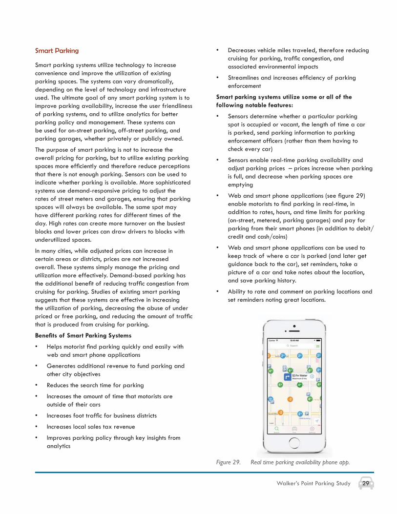
• Web and smart phone applications (see fi gure 29) enable motorists to fi nd parking in real-time, in addition to rates, hours, and time limits for parking (on-street, metered, parking garages) and pay for parking from their smart phones (in addition to debit/credit and cash/coins)
• Web and smart phone applications can be used to keep track of where a car is parked (and later get guidance back to the car), set reminders, take a picture of a car and take notes about the location, and save parking history.
• Ability to rate and comment on parking locations and set reminders noting great locations.
Figure 29. Real time parking availability phone app.
30 Walker’s Point Parking Study
Parking Structures
Downer Avenue Parking Structure
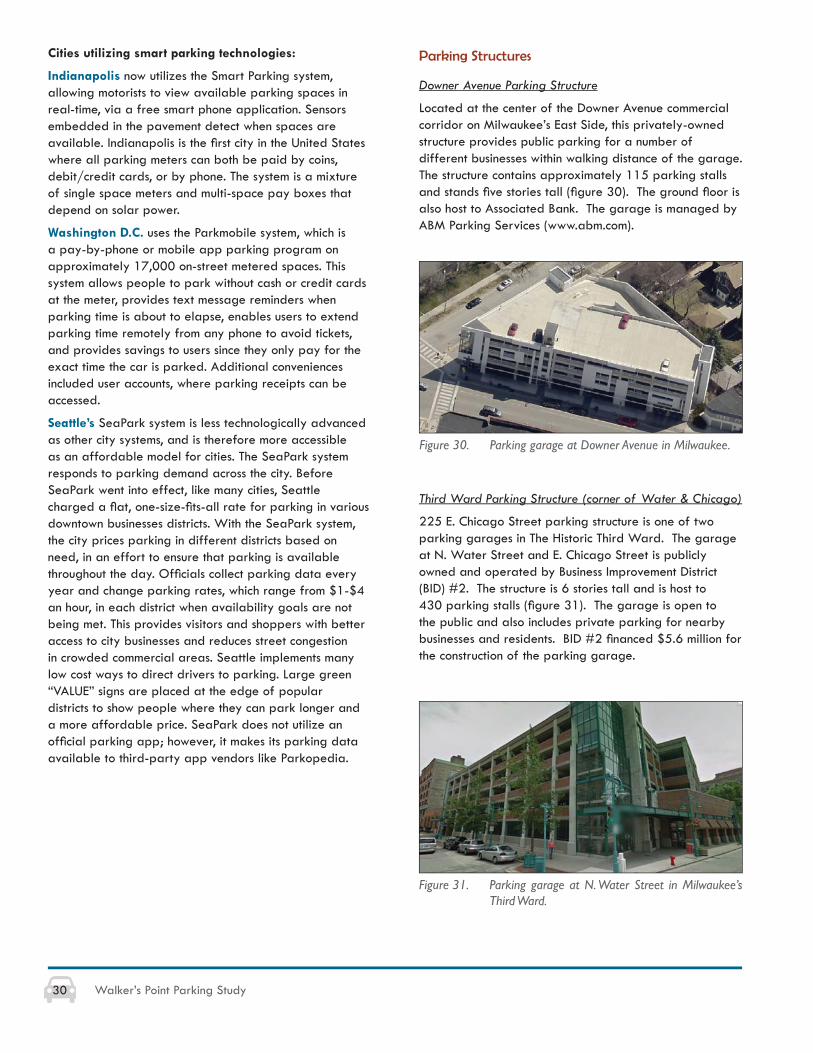
Located at the center of the Downer Avenue commercial corridor on Milwaukee’s East Side, this privately-owned structure provides public parking for a number of different businesses within walking distance of the garage. The structure contains approximately 115 parking stalls and stands fi ve stories tall (fi gure 30). The ground fl oor is also host to Associated Bank. The garage is managed by ABM Parking Services (www.abm.com).
Third Ward Parking Structure (corner of Water & Chicago)
225 E. Chicago Street parking structure is one of two parking garages in The Historic Third Ward. The garage at N. Water Street and E. Chicago Street is publicly owned and operated by Business Improvement District (BID) #2. The structure is 6 stories tall and is host to 430 parking stalls (fi gure 31). The garage is open to the public and also includes private parking for nearby businesses and residents. BID #2 fi nanced $5.6 million for the construction of the parking garage.
Figure 30. Parking garage at Downer Avenue in Milwaukee.
Figure 31. Parking garage at N. Water Street in Milwaukee’s Third Ward.
Cities utilizing smart parking technologies:
Indianapolis now utilizes the Smart Parking system, allowing motorists to view available parking spaces in real-time, via a free smart phone application. Sensors embedded in the pavement detect when spaces are available. Indianapolis is the fi rst city in the United States where all parking meters can both be paid by coins, debit/credit cards, or by phone. The system is a mixture of single space meters and multi-space pay boxes that depend on solar power.
Washington D.C. uses the Parkmobile system, which is a pay-by-phone or mobile app parking program on approximately 17,000 on-street metered spaces. This system allows people to park without cash or credit cards at the meter, provides text message reminders when parking time is about to elapse, enables users to extend parking time remotely from any phone to avoid tickets, and provides savings to users since they only pay for the exact time the car is parked. Additional conveniences included user accounts, where parking receipts can be accessed.
Seattle’s SeaPark system is less technologically advanced as other city systems, and is therefore more accessible as an affordable model for cities. The SeaPark system responds to parking demand across the city. Before SeaPark went into effect, like many cities, Seattle charged a fl at, one-size-fi ts-all rate for parking in various downtown businesses districts. With the SeaPark system, the city prices parking in different districts based on need, in an effort to ensure that parking is available throughout the day. Offi cials collect parking data every year and change parking rates, which range from $1-$4 an hour, in each district when availability goals are not being met. This provides visitors and shoppers with better access to city businesses and reduces street congestion in crowded commercial areas. Seattle implements many low cost ways to direct drivers to parking. Large green “VALUE” signs are placed at the edge of popular districts to show people where they can park longer and a more affordable price. SeaPark does not utilize an offi cial parking app; however, it makes its parking data available to third-party app vendors like Parkopedia.
31Walker’s Point Parking Study
APPROXIMATE PARKING SUPPLY AND DEMAND FOR USERS AND EMPLOYEES(Compact urban development with partial reliance on walking and transit)
Land Use Typical Demand Additional Considerations
VALUE OF PARKING
Land Use Building value per gsf Gsf per parking space Tax base per “needed” parking space
$175 650$350 250$125 650$200 250$125 400$150 300$150 250
Bank $125 300$125 250$200 100$250 50$0 250 $0
7. OPTIONS FOR PARKING STRUCTURES
Parking Supply, Demand, and Value
In most expanding urban redevelopment districts, the level of the district’s economic value depends on access for customers, employees, residents, and visitors. In the case of Walker’s Point, it is self-evident that one or more new public parking structures will be needed. The issues to be resolved include the location(s), size, and functional access patterns. For example, the knowledge that over the next decade there will be a need for 1,000+ indoor parking spaces is, alone, not useful. This section of the report outlines the types of issues and considerations that should be fundamental to the development of any new public access parking structures.
Each new use requires a reasonable amount of parking. Figure 32 depicts a range of expected land uses and the types of parking demand that may be generated (not specifi c to Walker’s Point). The table includes a range of supply and demand possibilities in order to illustrate the potential degree of uncertainty that must be addressed when considering the size, phasing, location, design, fi nancing, and management of parking structures.
Figure 32. Parking supply and demand table.
Figure 33. Value of parking.
Zoning and other public policies that standardize parking requirements rarely refl ect market conditions and, over time, are often modifi ed to refl ect those market forces.
As noted previously, predicting precise parking demand may not be meaningful given the dynamic nature of the last decade of development, changing social and cultural trends, and the uncertainty of future urban development patterns. Nonetheless, the large amount of currently available vacant or underutilized buildings plus the capacity of vacant land suggests that demands will increase sharply. This is fueled even further with the general pattern of increased market values along the east side of Milwaukee, new development that is already occurring, and the added potential of waterfront values along the edge of Walker’s Point.
As land values increase, the implicit fees for parking must also increase in order to pay for the equivalent value of space (see fi gure 33). Most dense urban areas remain “under parked” and thereby drive up the cost of new parking (appropriately) and also increase demand (and value of) transit, walking, bicycling, and ride sharing.
32 Walker’s Point Parking Study
Private versus Public Parking Structures
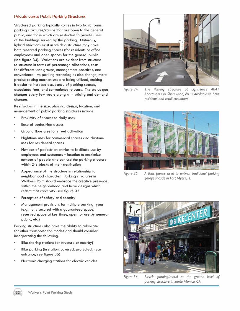
Structured parking typically comes in two basic forms: parking structures/ramps that are open to the general public, and those which are restricted to private users of the buildings served by the parking. Naturally, hybrid situations exist in which a structure may have both reserved parking spaces (for residents or offi ce employees) and open spaces for the general public (see fi gure 34). Variations are evident from structure to structure in terms of percentage allocations, costs for different user groups, management practices, and convenience. As parking technologies also change, more precise costing mechanisms are being utilized, making it easier to increase occupancy of parking spaces, associated fees, and convenience to users. The status quo changes every few years along with pricing and demand changes.
Key factors in the size, phasing, design, location, and management of public parking structures include:
• Proximity of spaces to daily uses
• Ease of pedestrian access
• Ground fl oor uses for street activation
• Nighttime uses for commercial spaces and daytime uses for residential spaces
• Number of pedestrian entries to facilitate use by employees and customers – location to maximize number of people who can use the parking structure within 2-3 blocks of their destination
• Appearance of the structure in relationship to neighborhood character. Parking structures in Walker’s Point should embrace the creative presence within the neighborhood and have designs which refl ect that creativity (see fi gure 35)
• Perception of safety and security
• Management provisions for multiple parking types (e.g., fully secured with a guaranteed space, reserved space at key times, open for use by general public, etc.)
Parking structures also have the ability to advocate for other transportation modes and should consider incorporating the following:
• Bike sharing stations (at structure or nearby)
• Bike parking (in station, covered, protected, near entrance, see fi gure 36)
• Electronic charging stations for electric vehicles
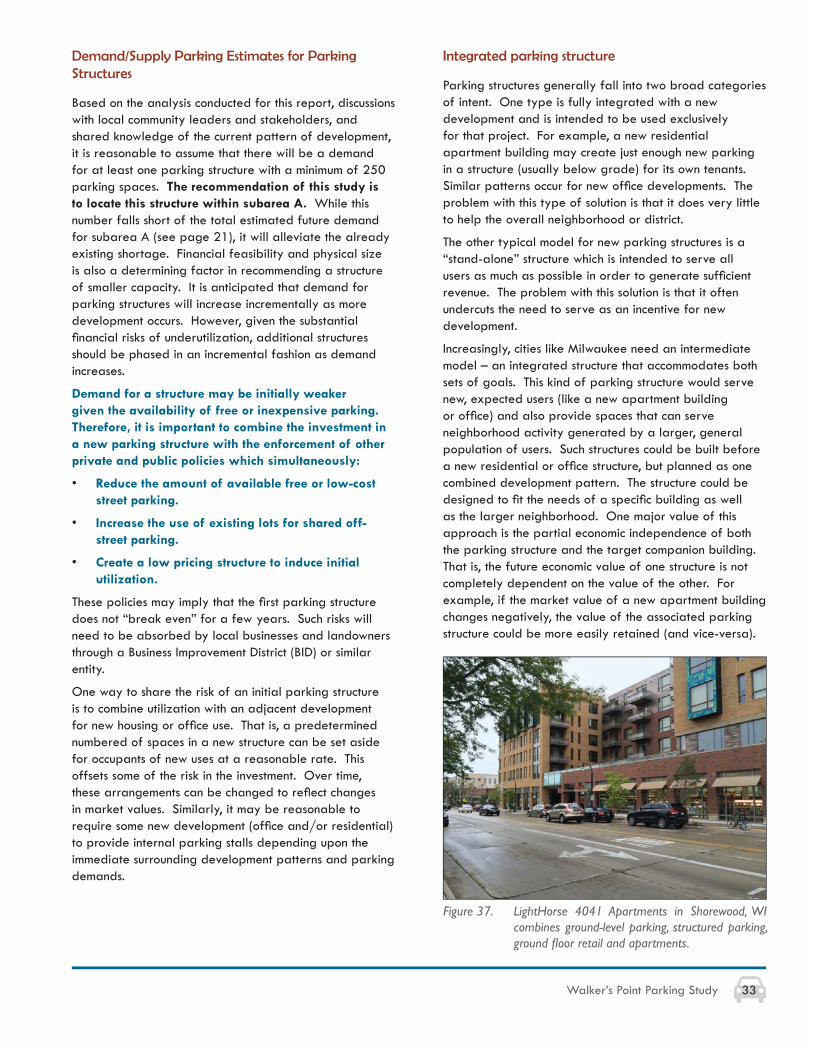
Figure 34. The Parking structure at LightHorse 4041 Apartments in Shorewood, WI is available to both residents and retail customers.
Figure 35. Artistic panels used to enliven traditional parking garage facade in Fort Myers, FL.
Figure 36. Bicycle parking/rental at the ground level of parking structure in Santa Monica, CA.
33Walker’s Point Parking Study
Demand/Supply Parking Estimates for Parking Structures
Based on the analysis conducted for this report, discussions with local community leaders and stakeholders, and shared knowledge of the current pattern of development, it is reasonable to assume that there will be a demand for at least one parking structure with a minimum of 250 parking spaces. The recommendation of this study is to locate this structure within subarea A. While this number falls short of the total estimated future demand for subarea A (see page 21), it will alleviate the already existing shortage. Financial feasibility and physical size is also a determining factor in recommending a structure of smaller capacity. It is anticipated that demand for parking structures will increase incrementally as more development occurs. However, given the substantial fi nancial risks of underutilization, additional structures should be phased in an incremental fashion as demand increases.
Demand for a structure may be initially weaker given the availability of free or inexpensive parking. Therefore, it is important to combine the investment in a new parking structure with the enforcement of other private and public policies which simultaneously:
• Reduce the amount of available free or low-cost street parking.
• Increase the use of existing lots for shared off-street parking.
• Create a low pricing structure to induce initial utilization.
These policies may imply that the fi rst parking structure does not “break even” for a few years. Such risks will need to be absorbed by local businesses and landowners through a Business Improvement District (BID) or similar entity.
One way to share the risk of an initial parking structure is to combine utilization with an adjacent development for new housing or offi ce use. That is, a predetermined numbered of spaces in a new structure can be set aside for occupants of new uses at a reasonable rate. This offsets some of the risk in the investment. Over time, these arrangements can be changed to refl ect changes in market values. Similarly, it may be reasonable to require some new development (offi ce and/or residential) to provide internal parking stalls depending upon the immediate surrounding development patterns and parking demands.
Integrated parking structure
Parking structures generally fall into two broad categories of intent. One type is fully integrated with a new development and is intended to be used exclusively for that project. For example, a new residential apartment building may create just enough new parking in a structure (usually below grade) for its own tenants. Similar patterns occur for new offi ce developments. The problem with this type of solution is that it does very little to help the overall neighborhood or district.
The other typical model for new parking structures is a “stand-alone” structure which is intended to serve all users as much as possible in order to generate suffi cient revenue. The problem with this solution is that it often undercuts the need to serve as an incentive for new development.
Increasingly, cities like Milwaukee need an intermediate model – an integrated structure that accommodates both sets of goals. This kind of parking structure would serve new, expected users (like a new apartment building or offi ce) and also provide spaces that can serve neighborhood activity generated by a larger, general population of users. Such structures could be built before a new residential or offi ce structure, but planned as one combined development pattern. The structure could be designed to fi t the needs of a specifi c building as well as the larger neighborhood. One major value of this approach is the partial economic independence of both the parking structure and the target companion building. That is, the future economic value of one structure is not completely dependent on the value of the other. For example, if the market value of a new apartment building changes negatively, the value of the associated parking structure could be more easily retained (and vice-versa).
Figure 37. LightHorse 4041 Apartments in Shorewood, WI combines ground-level parking, structured parking, ground fl oor retail and apartments.
34 Walker’s Point Parking Study
The following pages put forth a number of short- and long-term parking recommendations for the Walker’s Point neighborhood. A number of the short-term recommendations have the possibility of performing as interim (mid-term) solutions until long-term recommendations can be implemented.
Ongoing Monitoring of Parking Effectiveness
No matter how many times the supply and demand models are calculated, the real issue will be the day-to-day effectiveness of the parking network in the community. The best way to address this issue will be to conduct brief, targeted evaluations on an annual basis (minimum). The goals should be to further defi ne the scope of the problems for parking and the effi cacy of new interventions. These parking interventions should not necessarily be viewed as permanent changes, but interim experiments that are monitored for effectiveness. Parking interventions can then either stay or go depending on the success of the parking intervention. Data collection should include parking occupancy by time of day, time of week, season, and user type (customer, resident, employee). See the appendix for a sample “parking monitoring sheet” that can be used for ongoing monitoring.
Short-Term Action for Walker’s Point:
• Identify the “problem” areas according to time of day, time of week and user type and collect relevant data.
Mid-Term Action for Walker’s Point:
• Conduct monitoring of the specifi c problem area multiple times (e.g. weekday, weeknight, weekend) during peak time periods according to land use.
Long-Term Action for Walker’s Point:
• Conduct regular monitoring of occupancy for parking usage in all parking facilities and lots, including on-street parking and surface lots.
New Public Parking Technologies
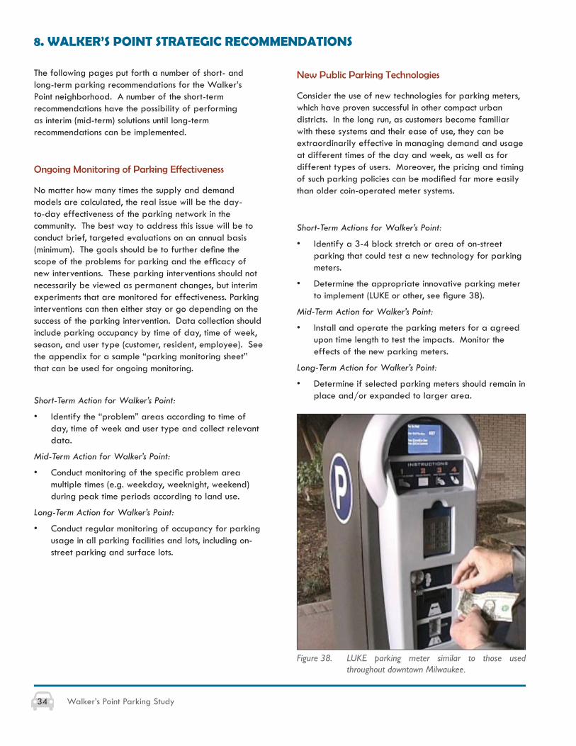
Consider the use of new technologies for parking meters, which have proven successful in other compact urban districts. In the long run, as customers become familiar with these systems and their ease of use, they can be extraordinarily effective in managing demand and usage at different times of the day and week, as well as for different types of users. Moreover, the pricing and timing of such parking policies can be modifi ed far more easily than older coin-operated meter systems.
Short-Term Actions for Walker’s Point:
• Identify a 3-4 block stretch or area of on-street parking that could test a new technology for parking meters.
• Determine the appropriate innovative parking meter to implement (LUKE or other, see fi gure 38).
Mid-Term Action for Walker’s Point:
• Install and operate the parking meters for a agreed upon time length to test the impacts. Monitor the effects of the new parking meters.
Long-Term Action for Walker’s Point:
• Determine if selected parking meters should remain in place and/or expanded to larger area.
8. WALKER’S POINT STRATEGIC RECOMMENDATIONS
Figure 38. LUKE parking meter similar to those used throughout downtown Milwaukee.
35Walker’s Point Parking Study
Shared Parking
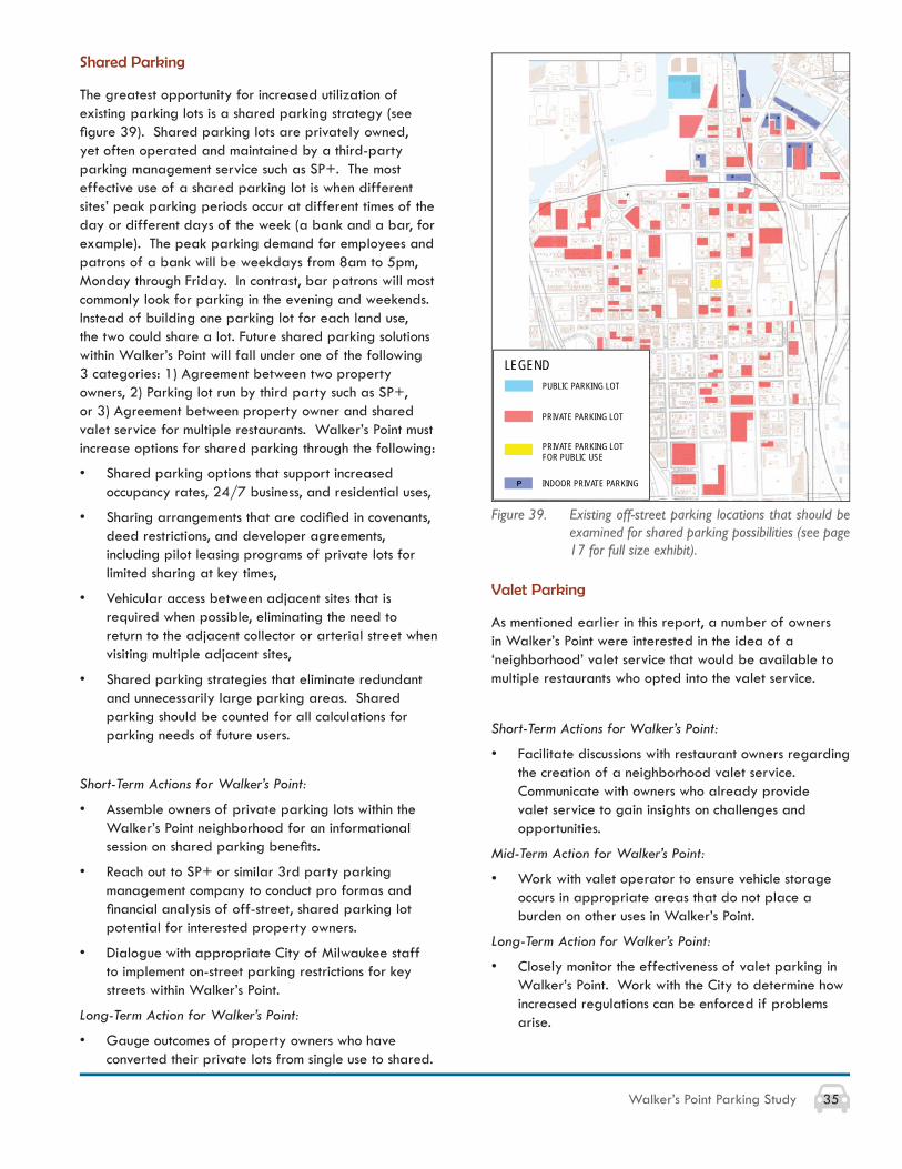
The greatest opportunity for increased utilization of existing parking lots is a shared parking strategy (see fi gure 39). Shared parking lots are privately owned, yet often operated and maintained by a third-party parking management service such as SP+. The most effective use of a shared parking lot is when different sites’ peak parking periods occur at different times of the day or different days of the week (a bank and a bar, for example). The peak parking demand for employees and patrons of a bank will be weekdays from 8am to 5pm, Monday through Friday. In contrast, bar patrons will most commonly look for parking in the evening and weekends. Instead of building one parking lot for each land use, the two could share a lot. Future shared parking solutions within Walker’s Point will fall under one of the following 3 categories: 1) Agreement between two property owners, 2) Parking lot run by third party such as SP+, or 3) Agreement between property owner and shared valet service for multiple restaurants. Walker’s Point must increase options for shared parking through the following:
• Shared parking options that support increased occupancy rates, 24/7 business, and residential uses,
• Sharing arrangements that are codifi ed in covenants, deed restrictions, and developer agreements, including pilot leasing programs of private lots for limited sharing at key times,
• Vehicular access between adjacent sites that is required when possible, eliminating the need to return to the adjacent collector or arterial street when visiting multiple adjacent sites,
• Shared parking strategies that eliminate redundant and unnecessarily large parking areas. Shared parking should be counted for all calculations for parking needs of future users.
Short-Term Actions for Walker’s Point:
• Assemble owners of private parking lots within the Walker’s Point neighborhood for an informational session on shared parking benefi ts.
• Reach out to SP+ or similar 3rd party parking management company to conduct pro formas and fi nancial analysis of off-street, shared parking lot potential for interested property owners.
• Dialogue with appropriate City of Milwaukee staff to implement on-street parking restrictions for key streets within Walker’s Point.
Long-Term Action for Walker’s Point:
• Gauge outcomes of property owners who have converted their private lots from single use to shared.
Figure 39. Existing off-street parking locations that should be examined for shared parking possibilities (see page 17 for full size exhibit).
Valet Parking
As mentioned earlier in this report, a number of owners in Walker’s Point were interested in the idea of a ‘neighborhood’ valet service that would be available to multiple restaurants who opted into the valet service.
Short-Term Actions for Walker’s Point:
• Facilitate discussions with restaurant owners regarding the creation of a neighborhood valet service. Communicate with owners who already provide valet service to gain insights on challenges and opportunities.
Mid-Term Action for Walker’s Point:
• Work with valet operator to ensure vehicle storage occurs in appropriate areas that do not place a burden on other uses in Walker’s Point.
Long-Term Action for Walker’s Point:
• Closely monitor the effectiveness of valet parking in Walker’s Point. Work with the City to determine how increased regulations can be enforced if problems arise.
LEGEND
PRIVATE PARKING LOT
INDOOR PRIVATE PARKINGP
PRIVATE PARKING LOT FOR PUBLIC USE
PUBLIC PARKING LOT
36 Walker’s Point Parking Study
Public Parking Regulations and Management
WPA must consider new concepts for parking regulations and management, such as:
• Installing new types of meters with fl exible pricing systems (including market-based pricing) and ease of use.
• Securing BID or Tax Incremental District (TID) support of parking ramp operation; consider possible cost/benefi t for 1st fl oor retail.
• Educating residents of overnight parking for residents by permit (http://city.milwaukee.gov/mpw/divisions/administrative/parking/ParkingPermits.htm).
• Providing clear wayfi nding to parking lots and garages.
• Providing off-peak exceptions to 1 or 2-hour parking limits.
• Securing customer validation for waiving parking violations.
• Enforcing seasonal guidelines to allow some on-street parking to be used for outdoor seating in warmer weather and during peak times for outdoor dining.
• Regulating inappropriate use by employees and non-customer users (including, for example, inappropriate Bradley Tech School staff parking on-street and not in designated parking lot).
• Creating additional on-street parking where possible.
Short-Term Action for Walker’s Point:
• Continued communication/education with existing “inappropriate” users of on-street parking spaces.
• Dialogue with appropriate City of Milwaukee staff to implement on-street parking restrictions for all streets within Walker’s Point.
Mid-Term Action for Walker’s Point:
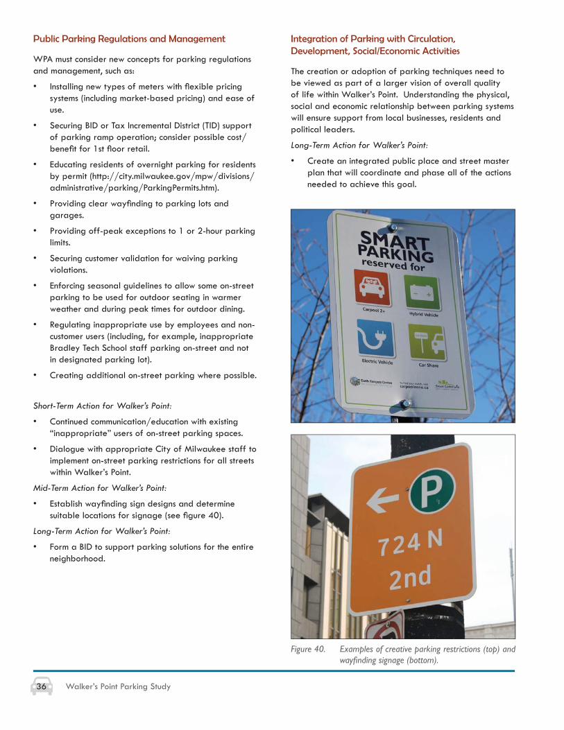
• Establish wayfi nding sign designs and determine suitable locations for signage (see fi gure 40).
Long-Term Action for Walker’s Point:
• Form a BID to support parking solutions for the entire neighborhood.
Figure 40. Examples of creative parking restrictions (top) and wayfi nding signage (bottom).
Integration of Parking with Circulation, Development, Social/Economic Activities
The creation or adoption of parking techniques need to be viewed as part of a larger vision of overall quality of life within Walker’s Point. Understanding the physical, social and economic relationship between parking systems will ensure support from local businesses, residents and political leaders.
Long-Term Action for Walker’s Point:
• Create an integrated public place and street master plan that will coordinate and phase all of the actions needed to achieve this goal.
37Walker’s Point Parking Study
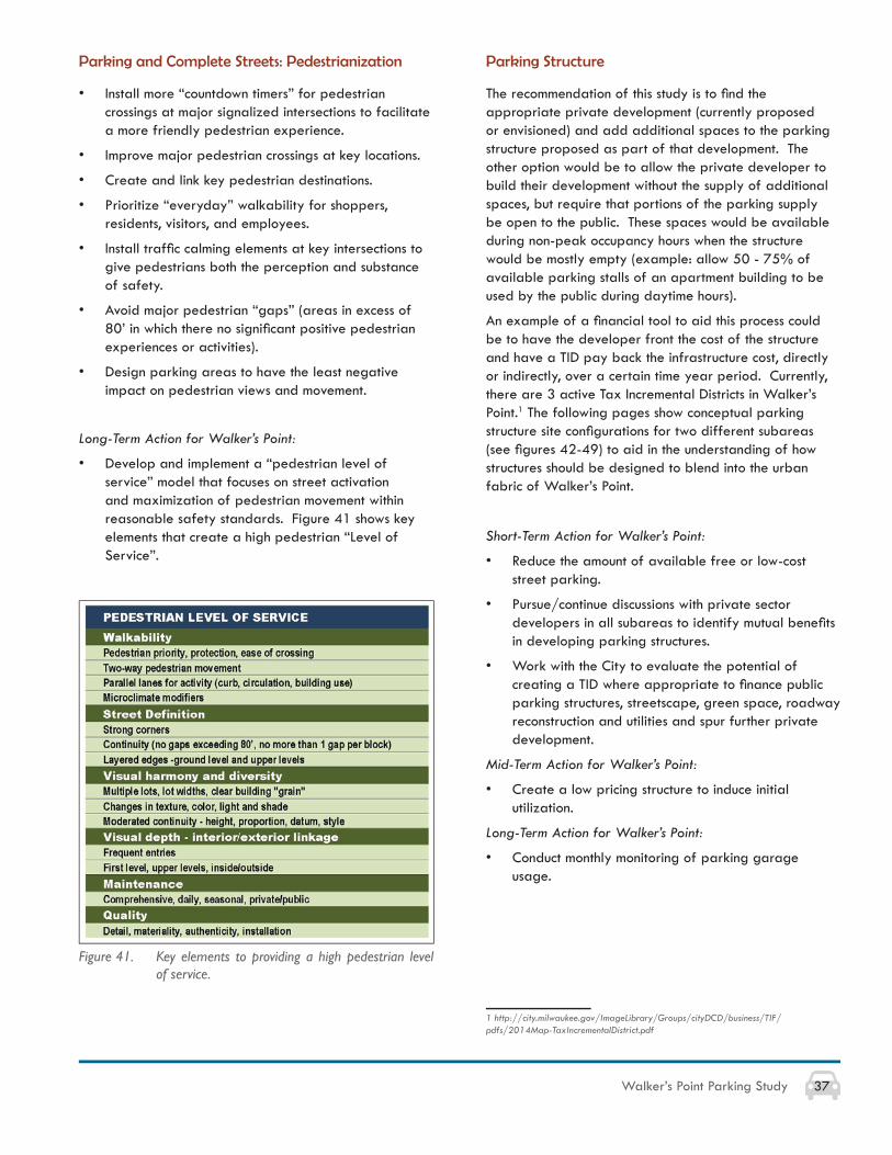
Parking and Complete Streets: Pedestrianization
• Install more “countdown timers” for pedestrian crossings at major signalized intersections to facilitate a more friendly pedestrian experience.
• Improve major pedestrian crossings at key locations.
• Create and link key pedestrian destinations.
• Prioritize “everyday” walkability for shoppers, residents, visitors, and employees.
• Install traffi c calming elements at key intersections to give pedestrians both the perception and substance of safety.
• Avoid major pedestrian “gaps” (areas in excess of 80’ in which there no signifi cant positive pedestrian experiences or activities).
• Design parking areas to have the least negative impact on pedestrian views and movement.
Long-Term Action for Walker’s Point:
• Develop and implement a “pedestrian level of service” model that focuses on street activation and maximization of pedestrian movement within reasonable safety standards. Figure 41 shows key elements that create a high pedestrian “Level of Service”.
Figure 41. Key elements to providing a high pedestrian level of service.
Parking Structure
The recommendation of this study is to fi nd the appropriate private development (currently proposed or envisioned) and add additional spaces to the parking structure proposed as part of that development. The other option would be to allow the private developer to build their development without the supply of additional spaces, but require that portions of the parking supply be open to the public. These spaces would be available during non-peak occupancy hours when the structure would be mostly empty (example: allow 50 - 75% of available parking stalls of an apartment building to be used by the public during daytime hours).
An example of a fi nancial tool to aid this process could be to have the developer front the cost of the structure and have a TID pay back the infrastructure cost, directly or indirectly, over a certain time year period. Currently, there are 3 active Tax Incremental Districts in Walker’s Point.1 The following pages show conceptual parking structure site confi gurations for two different subareas (see fi gures 42-49) to aid in the understanding of how structures should be designed to blend into the urban fabric of Walker’s Point.
Short-Term Action for Walker’s Point:
• Reduce the amount of available free or low-cost street parking.
• Pursue/continue discussions with private sector developers in all subareas to identify mutual benefi ts in developing parking structures.
• Work with the City to evaluate the potential of creating a TID where appropriate to fi nance public parking structures, streetscape, green space, roadway reconstruction and utilities and spur further private development.
Mid-Term Action for Walker’s Point:
• Create a low pricing structure to induce initial utilization.
Long-Term Action for Walker’s Point:
• Conduct monthly monitoring of parking garage usage.
1 http://city.milwaukee.gov/ImageLibrary/Groups/cityDCD/business/TIF/pdfs/2014Map-TaxIncrementalDistrict.pdf
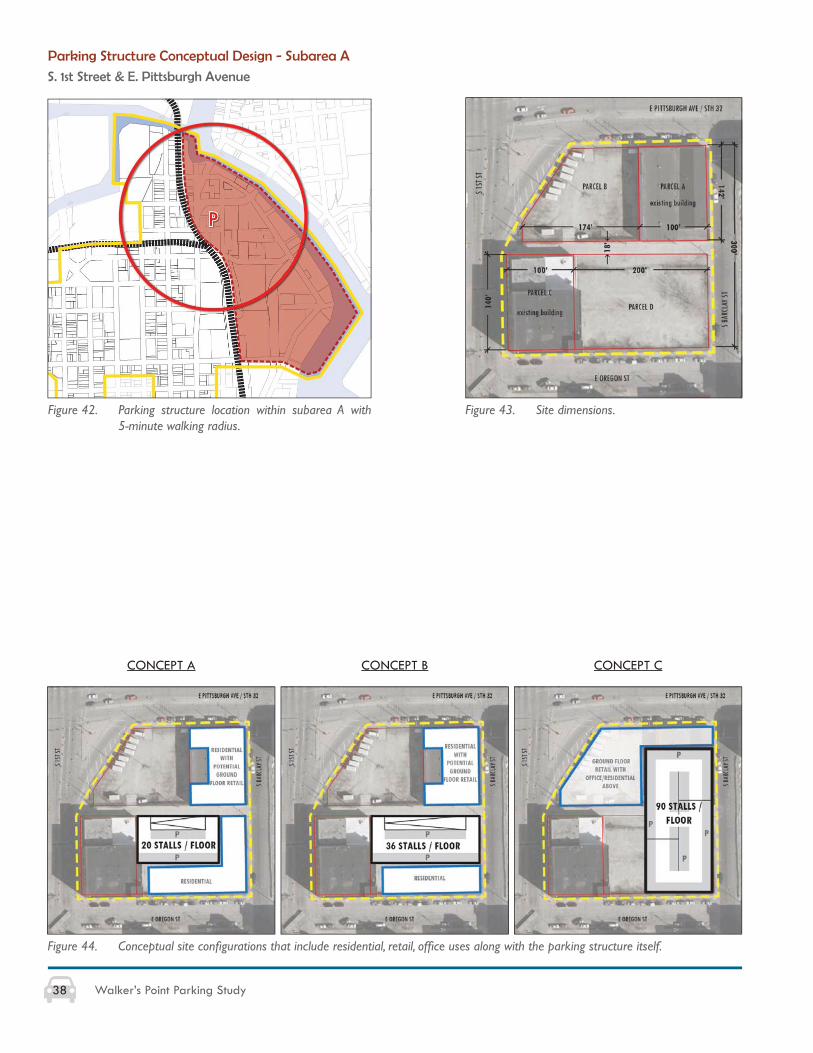
38 Walker’s Point Parking Study
Parking Structure Conceptual Design - Subarea A
S. 1st Street & E. Pittsburgh Avenue
Figure 42. Parking structure location within subarea A with 5-minute walking radius.
Figure 43. Site dimensions.
Figure 44. Conceptual site confi gurations that include residential, retail, offi ce uses along with the parking structure itself.
CONCEPT A CONCEPT B CONCEPT C
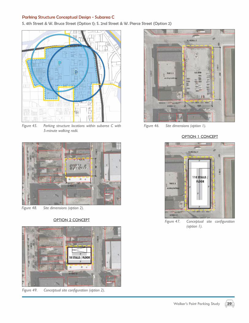
39Walker’s Point Parking Study
Parking Structure Conceptual Design - Subarea C
S. 4th Street & W. Bruce Street (Option 1); S. 2nd Street & W. Pierce Street (Option 2)
Figure 45. Parking structure locations within subarea C with 5-minute walking radii.
Figure 46. Site dimensions (option 1).
Figure 47. Conceptual site confi guration (option 1).
OPTION 1 CONCEPT
OPTION 2 CONCEPT
Figure 48. Site dimensions (option 2).
Figure 49. Conceptual site confi guration (option 2).

40 Walker’s Point Parking Study

41Walker’s Point Parking Study
APPENDICES, GLOSSARY & RESOURCES
APPENDIX A: WPA Issues and Opportunities Diagrams (7 pages, fi gures 50-56)
APPENDIX B: City of Milwaukee Zoning Ordinance 295-403. Parking (7 pages)
APPENDIX C: Sample Parking Monitoring Sheet
GLOSSARY OF PARKING TERMS
RESOURCES
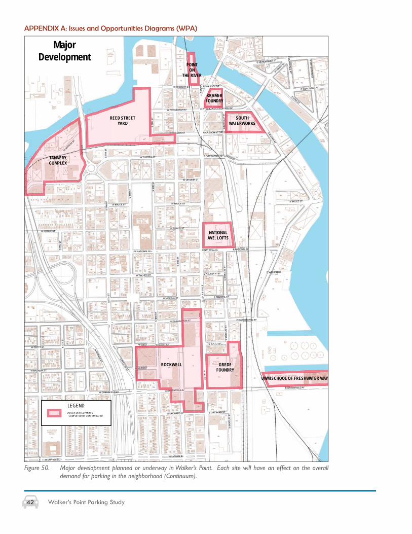
42 Walker’s Point Parking Study
LEGENDLARGER DEVELOPMENTS - COMPLETED OR CONTEMPLATED
MajorDevelopment
ROCKWELL GREDE FOUNDRY
UWM SCHOOL OF FRESHWATER WAY
NATIONAL AVE. LOFTS
SOUTHWATERWORKS
KRAMERFOUNDRY
REED STREET YARD
TANNERY COMPLEX
POINTON
THE RIVER
Figure 50. Major development planned or underway in Walker’s Point. Each site will have an effect on the overall demand for parking in the neighborhood (Continuum).
APPENDIX A: Issues and Opportunities Diagrams (WPA)
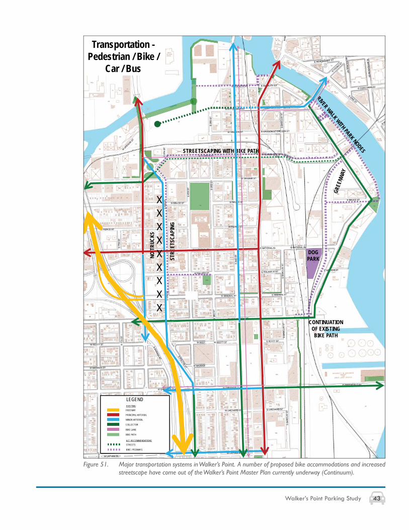
43Walker’s Point Parking Study
Transportation -Pedestrian / Bike /
Car / Bus
GREE
NWAY
RIVER WALK WITH PARK NODES
STRE
ETSC
APIN
G
NO T
RUCK
S
DOGPARK
CONTINUATIONOF EXISTINGBIKE PATH
STREETSCAPING WITH BIKE PATH
LEGEND
FREEWAY
PRINCIPAL ARTERIAL
COLLECTOR
BIKE LANE
BIKE PATH
MINOR ARTERIAL
STREETS
BIKE / PEDWAYS
EXISTING
ALT. RECOMMENDATIONS
XXXXXXXXX
Figure 51. Major transportation systems in Walker’s Point. A number of proposed bike accommodations and increased streetscape have come out of the Walker’s Point Master Plan currently underway (Continuum).
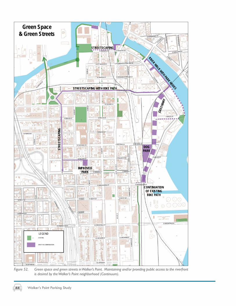
44 Walker’s Point Parking Study
EXISTING
LEGEND
Green Space& Green Streets
DRAFT RECOMMENDATION
STREETSCAPING
STREETSCAPING WITH BIKE PATH
STRE
ETSC
APIN
G
IMPROVEDPARK
DOGPARK
GREE
NWAY
RIVER WALK WITH PARK NODES
CONTINUATIONOF EXISTINGBIKE PATH
Figure 52. Green space and green streets in Walker’s Point. Maintaining and/or providing public access to the riverfront is desired by the Walker’s Point neighborhood (Continuum).
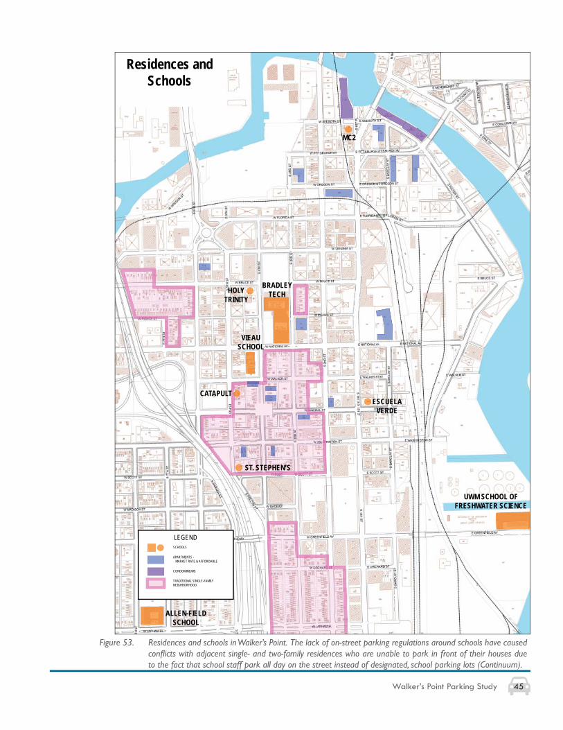
45Walker’s Point Parking Study
LEGENDSCHOOLS
APARTMENTS - MARKET RATE & AFFORDABLE
CONDOMINIUMS
TRADITIONAL SINGLE-FAMILYNEIGHBORHOOD
Residences and Schools
HOLY TRINITY
VIEAUSCHOOL
CATAPULT
ST. STEPHEN’S
ESCUELA VERDE
BRADLEY TECH
ALLEN-FIELDSCHOOL
MC2
UWM SCHOOL OF FRESHWATER SCIENCE
Figure 53. Residences and schools in Walker’s Point. The lack of on-street parking regulations around schools have caused confl icts with adjacent single- and two-family residences who are unable to park in front of their houses due to the fact that school staff park all day on the street instead of designated, school parking lots (Continuum).
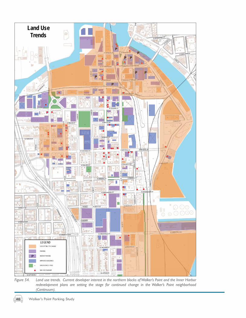
46 Walker’s Point Parking Study
LEGENDSUSCEPTIBLE TO CHANGE
PARKING
IMPROVED BUILDINGS
GREEN SPACE / TREE
BAR / RESTAURANT
PP P
P
P P
P
P
PP INDOOR PARKING
Land UseTrends
Figure 54. Land use trends. Current developer interest in the northern blocks of Walker’s Point and the Inner Harbor redevelopment plans are setting the stage for continued change in the Walker’s Point neighborhood (Continuum).
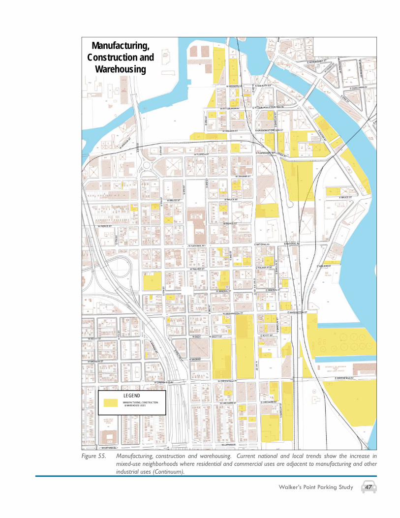
47Walker’s Point Parking Study
LEGENDMANUFACTURING, CONSTRUCTION & WAREHOUSE USES
Manufacturing,Construction and
Warehousing
Figure 55. Manufacturing, construction and warehousing. Current national and local trends show the increase in mixed-use neighborhoods where residential and commercial uses are adjacent to manufacturing and other industrial uses (Continuum).
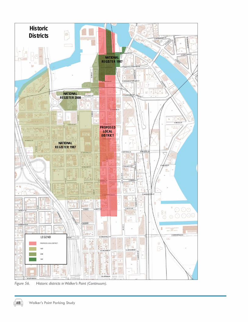
48 Walker’s Point Parking Study
NATIONAL REGISTER 1987
NATIONAL REGISTER 2008
LEGEND
1987
2008
1987
PROPOSED LOCAL DISTRICT
PROPOSEDLOCAL
DISTRICT
HistoricDistricts
NATIONAL REGISTER 1987
Figure 56. Historic districts in Walker’s Point (Continuum).
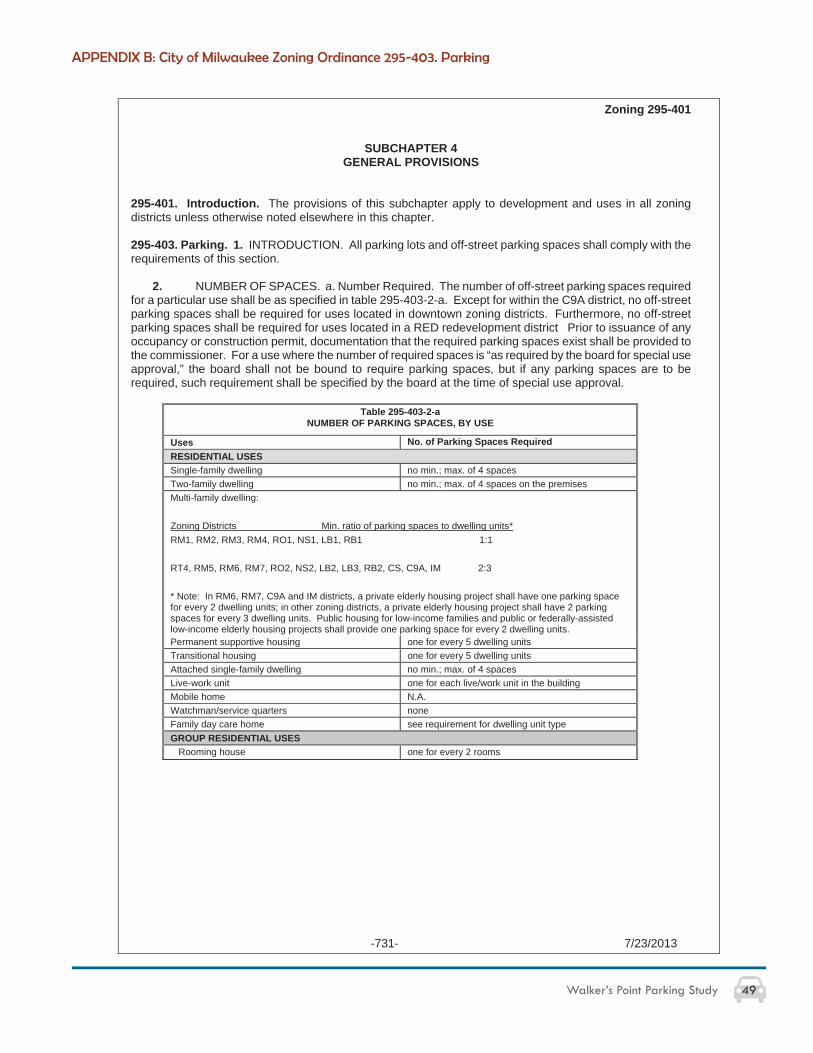
49Walker’s Point Parking Study
Zoning 295-401
-731- 7/23/2013
SUBCHAPTER 4 GENERAL PROVISIONS
295-401. Introduction. The provisions of this subchapter apply to development and uses in all zoning districts unless otherwise noted elsewhere in this chapter.
295-403. Parking. 1. INTRODUCTION. All parking lots and off-street parking spaces shall comply with the requirements of this section.
2. NUMBER OF SPACES. a. Number Required. The number of off-street parking spaces required for a particular use shall be as specified in table 295-403-2-a. Except for within the C9A district, no off-street parking spaces shall be required for uses located in downtown zoning districts. Furthermore, no off-street parking spaces shall be required for uses located in a RED redevelopment district Prior to issuance of any occupancy or construction permit, documentation that the required parking spaces exist shall be provided to the commissioner. For a use where the number of required spaces is “as required by the board for special use approval,” the board shall not be bound to require parking spaces, but if any parking spaces are to be required, such requirement shall be specified by the board at the time of special use approval.
Table 295-403-2-a NUMBER OF PARKING SPACES, BY USE
Uses No. of Parking Spaces Required RESIDENTIAL USESSingle-family dwelling no min.; max. of 4 spaces Two-family dwelling no min.; max. of 4 spaces on the premises Multi-family dwelling:
Zoning Districts Min. ratio of parking spaces to dwelling units* RM1, RM2, RM3, RM4, RO1, NS1, LB1, RB1 1:1
RT4, RM5, RM6, RM7, RO2, NS2, LB2, LB3, RB2, CS, C9A, IM 2:3
* Note: In RM6, RM7, C9A and IM districts, a private elderly housing project shall have one parking space for every 2 dwelling units; in other zoning districts, a private elderly housing project shall have 2 parking spaces for every 3 dwelling units. Public housing for low-income families and public or federally-assisted low-income elderly housing projects shall provide one parking space for every 2 dwelling units. Permanent supportive housing one for every 5 dwelling units Transitional housing one for every 5 dwelling units Attached single-family dwelling no min.; max. of 4 spaces Live-work unit one for each live/work unit in the building Mobile home N.A.Watchman/service quarters noneFamily day care home see requirement for dwelling unit type GROUP RESIDENTIAL USES Rooming house one for every 2 rooms
APPENDIX B: City of Milwaukee Zoning Ordinance 295-403. Parking
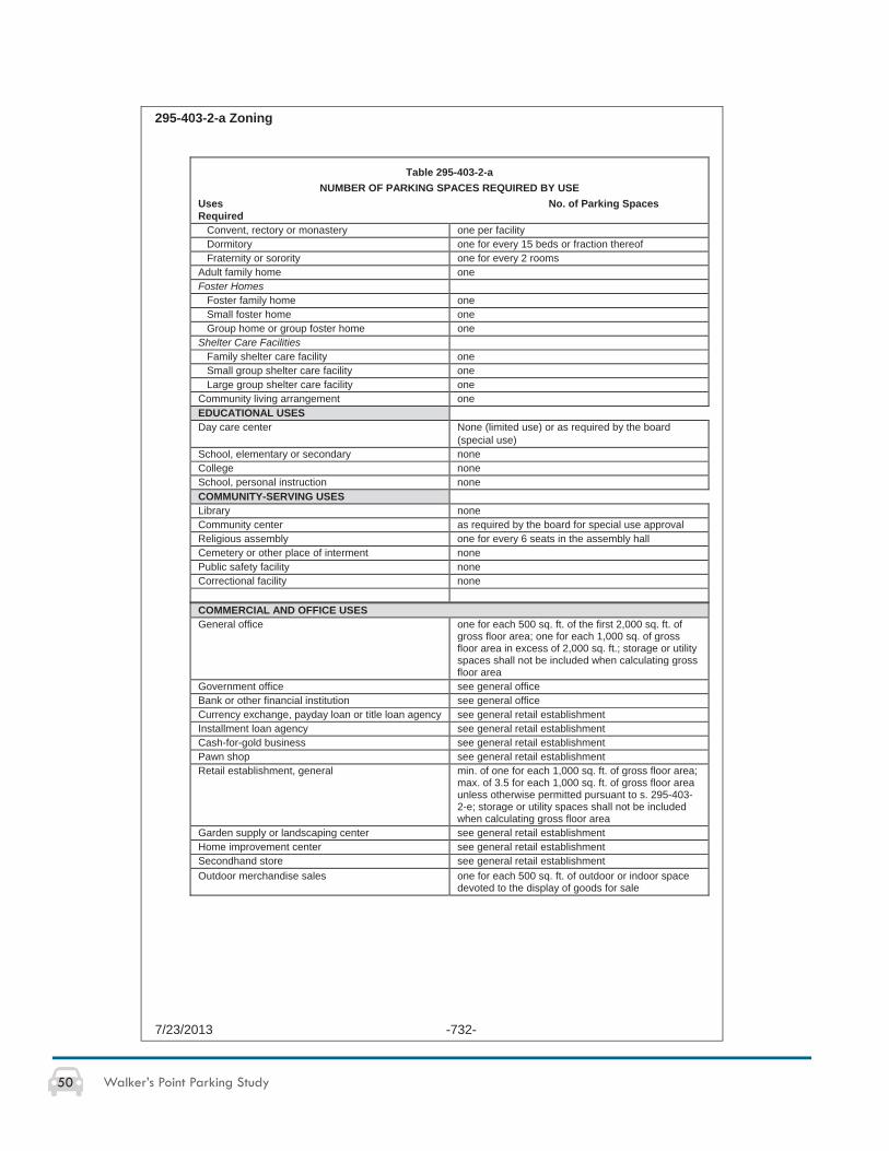
50 Walker’s Point Parking Study
295-403-2-a Zoning
7/23/2013 -732-
Table 295-403-2-a NUMBER OF PARKING SPACES REQUIRED BY USE
Uses No. of Parking Spaces Required Convent, rectory or monastery one per facility Dormitory one for every 15 beds or fraction thereof Fraternity or sorority one for every 2 rooms Adult family home one Foster Homes Foster family home one Small foster home one Group home or group foster home one Shelter Care Facilities Family shelter care facility one Small group shelter care facility one Large group shelter care facility one Community living arrangement one EDUCATIONAL USESDay care center None (limited use) or as required by the board
(special use) School, elementary or secondary none College none School, personal instruction none COMMUNITY-SERVING USESLibrary none Community center as required by the board for special use approval Religious assembly one for every 6 seats in the assembly hall Cemetery or other place of interment none Public safety facility none Correctional facility none
COMMERCIAL AND OFFICE USESGeneral office one for each 500 sq. ft. of the first 2,000 sq. ft. of
gross floor area; one for each 1,000 sq. of gross floor area in excess of 2,000 sq. ft.; storage or utility spaces shall not be included when calculating gross floor area
Government office see general office Bank or other financial institution see general office Currency exchange, payday loan or title loan agency see general retail establishment Installment loan agency see general retail establishment Cash-for-gold business see general retail establishment Pawn shop see general retail establishment Retail establishment, general min. of one for each 1,000 sq. ft. of gross floor area;
max. of 3.5 for each 1,000 sq. ft. of gross floor area unless otherwise permitted pursuant to s. 295-403-2-e; storage or utility spaces shall not be included when calculating gross floor area
Garden supply or landscaping center see general retail establishment Home improvement center see general retail establishment Secondhand store see general retail establishment Outdoor merchandise sales one for each 500 sq. ft. of outdoor or indoor space
devoted to the display of goods for sale
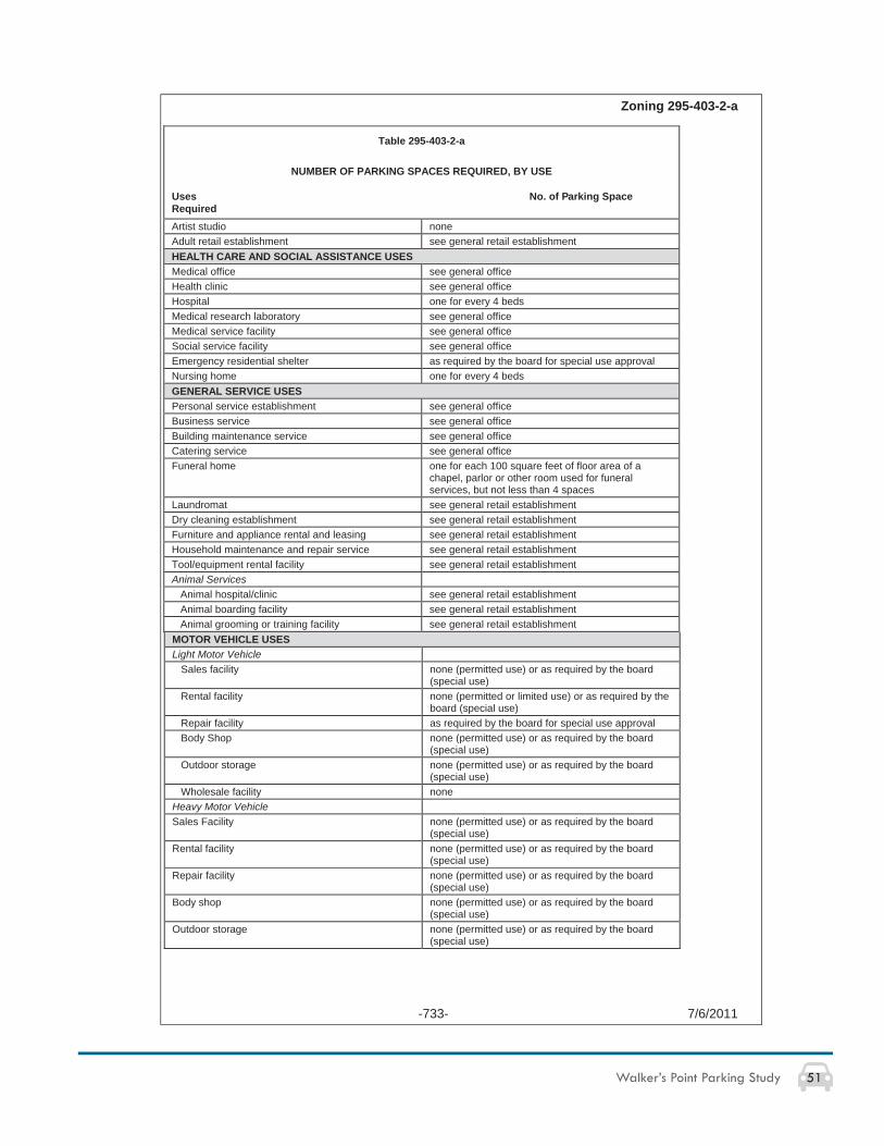
51Walker’s Point Parking Study
Zoning 295-403-2-a
-733- 7/6/2011
Table 295-403-2-a
NUMBER OF PARKING SPACES REQUIRED, BY USE
Uses No. of Parking Space RequiredArtist studio none Adult retail establishment see general retail establishment HEALTH CARE AND SOCIAL ASSISTANCE USESMedical office see general office Health clinic see general office Hospital one for every 4 beds Medical research laboratory see general office Medical service facility see general office Social service facility see general office Emergency residential shelter as required by the board for special use approval Nursing home one for every 4 beds GENERAL SERVICE USESPersonal service establishment see general office Business service see general office Building maintenance service see general office Catering service see general office Funeral home one for each 100 square feet of floor area of a
chapel, parlor or other room used for funeral services, but not less than 4 spaces
Laundromat see general retail establishment Dry cleaning establishment see general retail establishment Furniture and appliance rental and leasing see general retail establishment Household maintenance and repair service see general retail establishment Tool/equipment rental facility see general retail establishment Animal Services Animal hospital/clinic see general retail establishment Animal boarding facility see general retail establishment Animal grooming or training facility see general retail establishment MOTOR VEHICLE USESLight Motor Vehicle Sales facility none (permitted use) or as required by the board
(special use) Rental facility none (permitted or limited use) or as required by the
board (special use) Repair facility as required by the board for special use approval Body Shop none (permitted use) or as required by the board
(special use) Outdoor storage none (permitted use) or as required by the board
(special use) Wholesale facility noneHeavy Motor VehicleSales Facility none (permitted use) or as required by the board
(special use) Rental facility none (permitted use) or as required by the board
(special use) Repair facility none (permitted use) or as required by the board
(special use) Body shop none (permitted use) or as required by the board
(special use) Outdoor storage none (permitted use) or as required by the board
(special use)
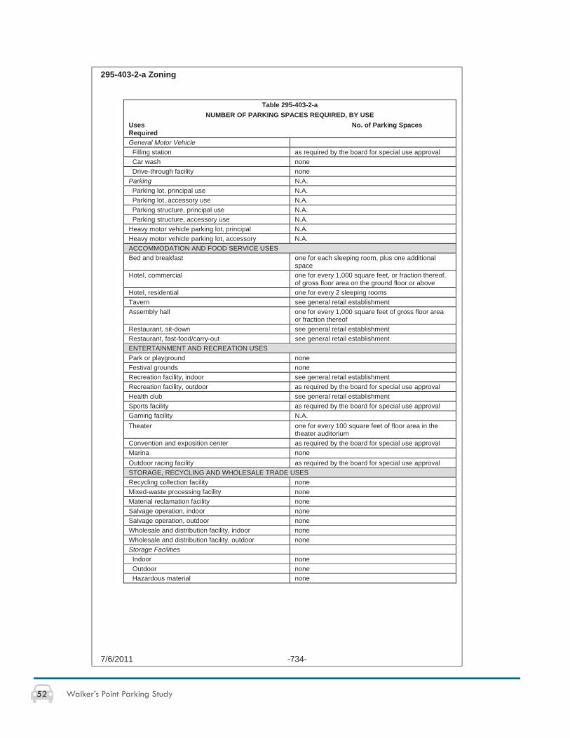
52 Walker’s Point Parking Study
295-403-2-a Zoning
7/6/2011 -734-
Table 295-403-2-a NUMBER OF PARKING SPACES REQUIRED, BY USE
Uses No. of Parking Spaces RequiredGeneral Motor Vehicle Filling station as required by the board for special use approval Car wash none Drive-through facility none Parking N.A. Parking lot, principal use N.A. Parking lot, accessory use N.A. Parking structure, principal use N.A. Parking structure, accessory use N.A. Heavy motor vehicle parking lot, principal N.A. Heavy motor vehicle parking lot, accessory N.A. ACCOMMODATION AND FOOD SERVICE USES Bed and breakfast one for each sleeping room, plus one additional
spaceHotel, commercial one for every 1,000 square feet, or fraction thereof,
of gross floor area on the ground floor or above Hotel, residential one for every 2 sleeping rooms Tavern see general retail establishment Assembly hall one for every 1,000 square feet of gross floor area
or fraction thereof Restaurant, sit-down see general retail establishment Restaurant, fast-food/carry-out see general retail establishment ENTERTAINMENT AND RECREATION USES Park or playground none Festival grounds none Recreation facility, indoor see general retail establishment Recreation facility, outdoor as required by the board for special use approval Health club see general retail establishment Sports facility as required by the board for special use approval Gaming facility N.A. Theater one for every 100 square feet of floor area in the
theater auditorium Convention and exposition center as required by the board for special use approval Marina none Outdoor racing facility as required by the board for special use approval STORAGE, RECYCLING AND WHOLESALE TRADE USES Recycling collection facility noneMixed-waste processing facility noneMaterial reclamation facility noneSalvage operation, indoor noneSalvage operation, outdoor noneWholesale and distribution facility, indoor noneWholesale and distribution facility, outdoor noneStorage Facilities Indoor none Outdoor none Hazardous material none
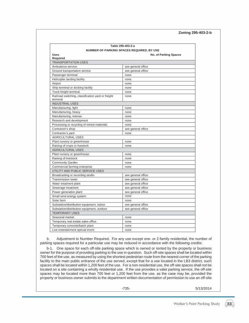
53Walker’s Point Parking Study
Zoning 295-403-2-b
-735- 5/13/2014
Table 295-403-2-a NUMBER OF PARKING SPACES REQUIRED, BY USE
Uses No. of Parking Spaces RequiredTRANSPORTATION USES Ambulance service see general office Ground transportation service see general office Passenger terminal none Helicopter landing facility none Airport none Ship terminal or docking facility none Truck freight terminal none Railroad switching, classification yard or freight terminal
none
INDUSTRIAL USES Manufacturing, light none Manufacturing, heavy none Manufacturing, intense none Research and development none Processing or recycling of mined materials none Contractor’s shop see general office Contractor’s yard none AGRICULTURAL USES Plant nursery or greenhouse none Raising of crops or livestock none AGRICULTURAL USES Plant nursery or greenhouse none Raising of livestock none Community Garden none Commercial farming enterprise none UTILITY AND PUBLIC SERVICE USES Broadcasting or recording studio see general office Transmission tower see general office Water treatment plant see general office Sewerage treatment see general office Power generation plant see general office Small wind energy system noneSolar farm none Substation/distribution equipment, indoor see general office Substation/distribution equipment, outdoor see general office TEMPORARY USES Seasonal market none Temporary real estate sales office none Temporary concrete/batch plant none Live entertainment special event none
b. Adjustment to Number Required. For any use except one- or 2-family residential, the number of parking spaces required for a particular use may be reduced in accordance with the following credits:
b-1. One space for each off-site parking space which is owned or rented by the property or business owner for the purpose of providing parking to the use in question. Such off-site spaces shall be located within 700 feet of the use, as measured by using the shortest pedestrian route from the nearest corner of the parking facility to the main public entrance of the use served, except that for a use located in the LB3 district, such spaces shall be located within 1,200 feet of the use. For a non-residential use, the off-site spaces shall not be located on a site containing a wholly residential use. If the use provides a valet parking service, the off-site spaces may be located more than 700 feet or 1,200 feet from the use, as the case may be, provided the property or business owner submits to the department written documentation of permission to use an off-site
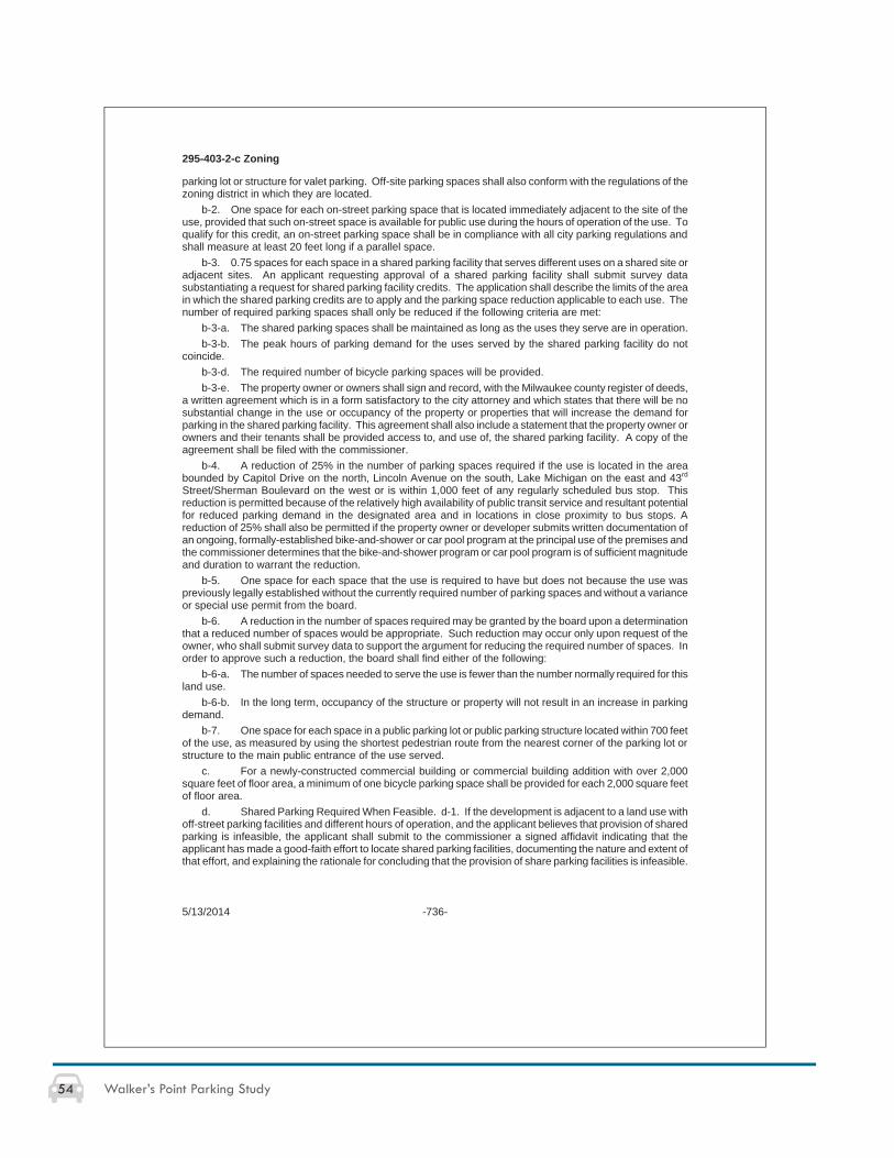
54 Walker’s Point Parking Study
295-403-2-c Zoning
5/13/2014 -736-
parking lot or structure for valet parking. Off-site parking spaces shall also conform with the regulations of the zoning district in which they are located.
b-2. One space for each on-street parking space that is located immediately adjacent to the site of the use, provided that such on-street space is available for public use during the hours of operation of the use. To qualify for this credit, an on-street parking space shall be in compliance with all city parking regulations and shall measure at least 20 feet long if a parallel space.
b-3. 0.75 spaces for each space in a shared parking facility that serves different uses on a shared site or adjacent sites. An applicant requesting approval of a shared parking facility shall submit survey data substantiating a request for shared parking facility credits. The application shall describe the limits of the area in which the shared parking credits are to apply and the parking space reduction applicable to each use. The number of required parking spaces shall only be reduced if the following criteria are met:
b-3-a. The shared parking spaces shall be maintained as long as the uses they serve are in operation. b-3-b. The peak hours of parking demand for the uses served by the shared parking facility do not
coincide.b-3-d. The required number of bicycle parking spaces will be provided. b-3-e. The property owner or owners shall sign and record, with the Milwaukee county register of deeds,
a written agreement which is in a form satisfactory to the city attorney and which states that there will be no substantial change in the use or occupancy of the property or properties that will increase the demand for parking in the shared parking facility. This agreement shall also include a statement that the property owner or owners and their tenants shall be provided access to, and use of, the shared parking facility. A copy of the agreement shall be filed with the commissioner.
b-4. A reduction of 25% in the number of parking spaces required if the use is located in the area bounded by Capitol Drive on the north, Lincoln Avenue on the south, Lake Michigan on the east and 43rd
Street/Sherman Boulevard on the west or is within 1,000 feet of any regularly scheduled bus stop. This reduction is permitted because of the relatively high availability of public transit service and resultant potential for reduced parking demand in the designated area and in locations in close proximity to bus stops. A reduction of 25% shall also be permitted if the property owner or developer submits written documentation of an ongoing, formally-established bike-and-shower or car pool program at the principal use of the premises and the commissioner determines that the bike-and-shower program or car pool program is of sufficient magnitude and duration to warrant the reduction.
b-5. One space for each space that the use is required to have but does not because the use was previously legally established without the currently required number of parking spaces and without a variance or special use permit from the board.
b-6. A reduction in the number of spaces required may be granted by the board upon a determination that a reduced number of spaces would be appropriate. Such reduction may occur only upon request of the owner, who shall submit survey data to support the argument for reducing the required number of spaces. In order to approve such a reduction, the board shall find either of the following:
b-6-a. The number of spaces needed to serve the use is fewer than the number normally required for this land use.
b-6-b. In the long term, occupancy of the structure or property will not result in an increase in parking demand.
b-7. One space for each space in a public parking lot or public parking structure located within 700 feet of the use, as measured by using the shortest pedestrian route from the nearest corner of the parking lot or structure to the main public entrance of the use served.
c. For a newly-constructed commercial building or commercial building addition with over 2,000 square feet of floor area, a minimum of one bicycle parking space shall be provided for each 2,000 square feet of floor area.
d. Shared Parking Required When Feasible. d-1. If the development is adjacent to a land use with off-street parking facilities and different hours of operation, and the applicant believes that provision of shared parking is infeasible, the applicant shall submit to the commissioner a signed affidavit indicating that the applicant has made a good-faith effort to locate shared parking facilities, documenting the nature and extent of that effort, and explaining the rationale for concluding that the provision of share parking facilities is infeasible.
55Walker’s Point Parking Study
Zoning 295-403-3
-737- 12/21/2010
d-2. An applicant for a mixed residential and commercial development or a shopping center development adjacent to one or more existing mixed residential and commercial developments or shopping center developments shall submit to the commissioner a parking demand study that indicates whether off-street parking for the proposed development can be combined with off-street parking at the existing developments.
e. Exception to Exceed Maximum Number of Parking Spaces. e-1. The number of parking spaces provided for a general retail establishment, or for any land use for which the parking space requirement for a general retail establishment is cross-referenced in table 295-403-2-a, may exceed the maximum specified in table 295-403-2-a if the commissioner finds one or more of the following to be true:
e-1-a. The additional spaces will be located in a parking structure. e-1-b. The development site will contain additional facilities for the handling or treatment of storm water
runoff.e-1-c. A parking demand study indicates that provision of more than the maximum number of spaces is
warranted by anticipated parking demand. e-1-d. The adverse environmental effects of allowing additional parking spaces will be offset by other
mitigation measures approved by the commissioner, including but not limited to the creation or preservation of wetlands, acquisition of open space or implementation of storm water best management practices, as defined in s. 120-3-2, within the same watershed, as defined in s. 295-201-678.
e-2. To qualify for the exception from the maximum number of parking spaces permitted, the property owner, developer or other applicant shall submit to the commissioner a written plan and supporting documents indicating an acceptable manner in which one or more of the criteria in subd. 1 will be met.
e-3. If the commissioner determines, using the criteria in subd. 1, that an exception from the maximum number of parking spaces is not warranted, the property owner, developer or other applicant may appeal the commissioner's determination to the board. The board shall consider the appeal in the same manner it considers a request for a dimensional variance.
3. STANDARDS OF DESIGN. a. Dimensions. Parking spaces shall contain at least 160 square feet, excluding drives, lanes or aisles, and be provided with an unobstructed access lane thereto from a public street, alley or other open space approved by the commissioner, except that spaces designated for compact cars shall contain at least 120 square feet. A minimum of 50% of the required parking spaces in a parking area shall be designated for compact cars.
b. Paving. All areas used for the parking of motor vehicles or trailers or light or heavy motor vehicle storage shall have paved or approved surfaces, as required in s. 252-74. The use of permeable paving, as defined in s. 200-08-68.5, is encouraged for all parking spaces provided above the minimum number required by this chapter.
c. Bicycle Parking Spaces. For each required bicycle parking space, a stationary object shall be provided to which a user can secure the frame and both wheels of a bicycle with a 6-foot cable and lock. The stationary object may be either a freestanding bicycle rack or a wall-mounted bracket, shall be located within 60 feet of the main entrance of the building it serves, and may be located between the street curb and the building, subject to the approval of the commissioner of public works. As an alternative, the following alternative bicycle parking facilities may be provided:
c-1. Enclosed bicycle lockers. c-2. A 3-point bicycle rack which secures the frame and both wheels of each bike. c-3. A fenced, covered, locked or guarded bicycle storage area. Such area shall be large enough that
each of the required bicycle parking spaces can accommodate a bicycle with a 3-foot handlebar width, a height of 3.5 feet from the bottom of the wheel to the top of the handlebar, and a length of 6 feet from the front of the forward wheel to the back of the rear wheel.
56 Walker’s Point Parking Study
PARKING IN WALKER’S POINT - MONITORING SHEET
DATE/TIME:
_____________________________________________________________________________
LOCATION OF MONITORING CONDUCTED (e.g. address, block(s)):
_____________________________________________________________________________
PARKING TYPE BEING MONITORED (e.g. private, public, on-street, off-street, metered, unmetered):
_____________________________________________________________________________
_____________________________________________________________________________
_____________________________________________________________________________
OBSERVATIONS:
_____________________________________________________________________________
_____________________________________________________________________________
_____________________________________________________________________________
_____________________________________________________________________________
_____________________________________________________________________________
_____________________________________________________________________________
_____________________________________________________________________________
_____________________________________________________________________________
_____________________________________________________________________________
_____________________________________________________________________________
_____________________________________________________________________________
_____________________________________________________________________________
_____________________________________________________________________________
Attach relevant maps/site plans/graphics/photos to this cover sheet
APPENDIX C: Sample Parking Monitoring Sheet
57Walker’s Point Parking Study
GLOSSARY
ACCESSORY BUILDING means a building on the same lot as a principal structure and customarily incidental and subordinate to the principal structure or use.
ACCESSORY USE means a use of land or of a structure or portion thereof customarily incidental and subordinate to the principal use of the land or structure and located on the same site or development site as the principal use.
COMPLETE STREET means a street designed and operated to enable safe access for all users, including pedestrians, bicyclists, motorists and transit riders of all ages and abilities. Complete Streets make it easy to cross the street, walk to shops, and bicycle to work.
DYNAMIC PRICING (variable rates or fl exible pricing) means a parking structure system that is responsive to elements such as peak demand and parking supply in an effort to infl uence traveler mode choice, time and amount of travel, and reduce congestion.
LIMITED USE means a use which is generally compatible with permitted uses in a given zoning district, but has operating or physical characteristics that require certain conditions be placed on the use.
PARKING FACILITY means any type of physical structure or area where a vehicle may park (e.g. parking garage, parking lot, on-street parking stall).
PARKING, METERED means a stall that is associated with a device that registers the amount of time purchased for the parking of a vehicle, at the expiration of which the driver is liable for a fi ne.
PARKING, RESTRICTED (assigned or reserved) means a parking lot or stall that is reserved for a specifi c user for a specifi c period of time.
PARKING, SHARED means a parking facility that serves two or more individual land uses without confl ict or encroachment.
PARKING, UNRESTRICTED (non-assigned) means a parking lot or stall that is open to any user and contains no limits to parking duration at the specifi c location.
PARKING, VALET means a service provided by a business (typically bars or restaurants) where an attendant parks and retrieves patrons’ vehicle instead of the vehicle owner searching for parking.
PARKING SPACE, DEDICATED (similar to off-street) means any parking space that is located on the same premises as the use it serves and is not located on public right-of-way.
PARKING SPACE, OFF-STREET means any parking stall located outside the public, street right-of-way.
PARKING SPACE, ON-STREET means any parking stall located within the public, street right-of-way.
PARKING STRUCTURE, ACCESSORY USE (or integrated parking structure) means parking spaces and adjacent access drives, aisles and ramps that are located in a structure with 2 or more levels, where the parking structure is not the principal use of the premises. This term does not include private one-story garages for single-, 2- or multi-family dwellings but does include parking spaces that are integrated into a larger structure that houses the principal use of the premises.
PARKING STRUCTURE, PRINCIPAL USE means parking spaces and adjacent access drives, aisles and ramps that are located in a structure with 2 or more levels, where the parking structure is the principal use of the premises. This term includes commercial parking operations as well as private parking structures. This term does not include private one-story garages for single-, 2- or multi-family dwellings.
SMART PARKING means systems that utilize technology to increase convenience and improve the utilization of existing parking spaces.
WALKABLE COMMUNITY means an area where it is easy and safe to walk to goods and services (i.e., farmers market, schools, offi ces, restaurants, etc.). Walkable communities encourage pedestrian activity, expand transportation options, and have safe and inviting streets that serve people with different ranges of mobility.
(Glossary sources include the City of Milwaukee Code of Ordinances and Walker’s Point Parking Study Group research)
58 Walker’s Point Parking Study
RESOURCES
http://city.milwaukee.gov/AreaPlans/NearSouth.htm
http://city.milwaukee.gov/Directory/DPW/DPW-Services/Parking-Services--Info.htm
http://city.milwaukee.gov/Projects/ReedStreetYards.htm
http://city.milwaukee.gov/PlansandStudies/PortofMilwaukee.htm
http://harbordistrict.org/
http://safety.fhwa.dot.gov/ped_bike/ped_cmnity/ped_walkguide/about.cfm
http://www.citylab.com/work/2013/10/how-seattle-transformed-parking-without-spending-fortune/7348/
http://www.parkindy.net/
http://www.seattle.gov/transportation/parking/docs/2013_Paid_Parking_Report_fi nal_7_18_13v3.pdf
http://www.smartgrowthamerica.org/complete-streets/complete-streets-fundamentals/complete-streets-faq
http://www.streetline.com/2012/03/parkindy-and-streetline-bring-smart-parking-technology-to-indianapolis/
Parking Strategies to Support Livable Communities. Chicago: Chicago Metropolitan Agency for Planning, 2012.
http://www.cmap.illinois.gov/documents/10180/87301/StepByStep3.pdf/39fa6452-2e19-4691-87bd-abac8b06c248
Shoup, Donald C. The High Cost of Free Parking. Chicago: Planners, American Planning Association, 2005.

59Walker’s Point Parking Study
