walking trails in port erin - isle of man government · walking trails in welcome to our...
TRANSCRIPT

WALKING TRAILS IN
Welcome to our Self-Guided walking trails of Port Erin
Purt Chiarn is Manx Gaelic for Port Erin, meaning the Irish Port, Iron Port, the Lord’s Port or possibly Westerly Port (Purt Sheeayrn).
Piggott’s Directory of 1837 describes a village and sea port of forty dwellings, a small Wesleyan chapel and a comfortable inn. Local trades included farmers and fishermen, a cartwright, a fish curer, shopkeepers and various dealers and taverns. The village has adapted to change and embraced the age of tourism. Liverpool safe-maker William Milner, marine biologist William Herdman and artist William Hoggatt all chose Port Erin as their home and have left lasting legacies.
Port Erin
We have been asked to give some indication of how long these three walks would take.This is difficult as it will depend on the physical capabilities of the walker, their particular interests and, inevitably, the weather.
The map on the back page highlights the numbered points contained in each of the walks while the accompanying text alongside shows the extent of each walk.
Accessibilty Statement The lower Promenade (Shore Road) and beach are 20 metres below the main part of the town and can be accessed via road or a variety of paths. Some paths are quite steep and/or have steps. It is possible to see the majority of places of interest from the upper Promenade without using the steps and/or steep slopes.
Acknowledgements:Front cover image: courtesy of Seamus WhelanOther modern-day images: courtesy of Sylvia ConstantineOur appreciation and grateful thanks to all those involved in the road testing of these Trails and production of this leaflet and thanks to the department of Tourism, Port Erin Commissioners and Shoprite for their financial supportPort Erin Traders Association, August 2017

The starting point for all 3 Trails is Port Erin Steam Railway Station
Trail 1 (Points 1 – 6)
1. Railway StationThe 3ft narrow gauge Douglas - Port Erin Steam Railway line opened in 1874 and runs for 15 miles. It is all that remains of the original island steam railway system. The station building dates from 1904 and retains most of its original features,including a clock with two faces so it can be viewed from both inside and out.
On leaving the railway station turn left along Station Road
2. Railway Museum Opened in 1975, the museum’s exhibits present a history of the Isle of Man steam railway system, which was the inspiration for the Rev. Audry’s ‘Thomas the Tank Engine’ stories.
Continue along Station Road to the
3. Falcon’s Nest HotelBuilt in 1860 on land owned by William Milner, the Falcon’s Nest claims to be the village’s first hotel. Originally called the Port Erin Castle, it still retains its castellated rooftop.
4. Port Erin BayStop by the grass verge beyond the Falcon’s Nest to admire the view of this horseshoe bay. To the left side of the bay, the green & white lighthouse is at the end of the Raglan Pier while the lifeboat station is the ramped white rectangular building beyond it. The green shark’s fin buoy in the centre of the bay signs the end of the ill-fated and short-lived 19th century breakwater, and continues to mark safe passage into the harbour.
On a clear day, you can see outlined on the horizon the Mountains of Mourne in Northern Ireland, 50 miles away. A local saying goes ‘If you can see the Mountains of Mourne it’s going to rain, if you can’t see them – it is raining’.
Port Erin Bay has been a marine conservation area closed to commercial fishing since1989, and is recognised world-wide for the success of this measure. During early summer, basking sharks can sometimes be seen, with Minke whales, Risso’s dolphins and porpoises off Bradda Head.
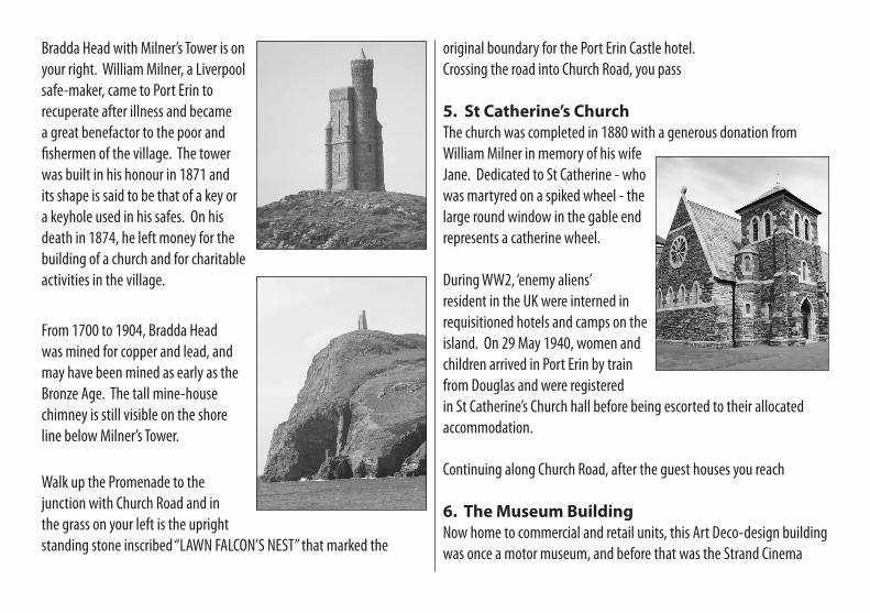
Bradda Head with Milner’s Tower is on your right. William Milner, a Liverpool safe-maker, came to Port Erin to recuperate after illness and became a great benefactor to the poor and fishermen of the village. The tower was built in his honour in 1871 and its shape is said to be that of a key or a keyhole used in his safes. On his death in 1874, he left money for the building of a church and for charitable activities in the village.
From 1700 to 1904, Bradda Head was mined for copper and lead, and may have been mined as early as the Bronze Age. The tall mine-house chimney is still visible on the shore line below Milner’s Tower.
Walk up the Promenade to the junction with Church Road and in the grass on your left is the upright standing stone inscribed “LAWN FALCON’S NEST” that marked the
original boundary for the Port Erin Castle hotel.Crossing the road into Church Road, you pass
5. St Catherine’s ChurchThe church was completed in 1880 with a generous donation from William Milner in memory of his wife Jane. Dedicated to St Catherine - who was martyred on a spiked wheel - the large round window in the gable end represents a catherine wheel. During WW2, ‘enemy aliens’ resident in the UK were interned in requisitioned hotels and camps on the island. On 29 May 1940, women and children arrived in Port Erin by train from Douglas and were registered in St Catherine’s Church hall before being escorted to their allocated accommodation.
Continuing along Church Road, after the guest houses you reach
6. The Museum BuildingNow home to commercial and retail units, this Art Deco-design building was once a motor museum, and before that was the Strand Cinema
from 1935 to 1971.Continue along Church Road, passing on your left the site of a former kipper factory. Here was also the home of Leonard McCombe, a renowned photographer who worked for Time magazine and one of whose photos was the inspiration behind the “Marlboro Man” image.
At the T-junction at the end, turn right into Bridson Street to return to Station Road and the railway station.
Trail 2 (follows Points 1 – 4 then 7 – 20)
7. Continuing up the Promenade Passing St Catherine’s Church (see Point 5), you then pass Eagle Towers and Marina Lane. Prior to the building of the apartments, this site was occupied by the Eagle Hotel which was originally named the Villa Marina Hotel, hence the continuing use of both names.
Walk further up the Promenade to
8. Victoria Square on your rightMost of the properties around the Square were built in the 1890s and early 1900s as boarding houses for the growing tourist industry. The Erin Arts Centre is a former Wesleyan Methodist chapel, sold to Dr
John Bethell MBE in 1971, which has been converted to create a Manx international venue for music, drama and visual art.
Continue up the Promenade towards the steps opposite Bay View Road. You will pass on the kerb edge a
9. Red & white striped lamppost with a red lightThe Trail now takes you down the steps onto the Lower Promenade on the beach below. While walking down the steps, pause to note the white trapezoid shape painted on the wall to the left below the position of the lamppost. Viewed from out at sea, these two markers combined with the lighthouse on the beach below, line up to give vessels a safe passage into the bay. They date from about 1884 and still serve the same purpose today.
The Cosy Nook café is to your right but the Trail goes left along
10. St Catherine’s Terrace The six fishermen’s cottages were built by William Milner and were left to the church as a source of rent. The separate front gardens are well-known locally and are a joy to see.
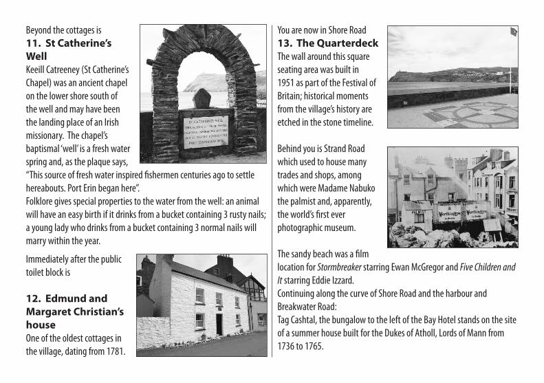
Beyond the cottages is11. St Catherine’s WellKeeill Catreeney (St Catherine’s Chapel) was an ancient chapel on the lower shore south of the well and may have been the landing place of an Irish missionary. The chapel’s baptismal ‘well’ is a fresh water spring and, as the plaque says, “This source of fresh water inspired fishermen centuries ago to settle hereabouts. Port Erin began here”. Folklore gives special properties to the water from the well: an animal will have an easy birth if it drinks from a bucket containing 3 rusty nails; a young lady who drinks from a bucket containing 3 normal nails will marry within the year.
Immediately after the public toilet block is
12. Edmund and Margaret Christian’s houseOne of the oldest cottages in the village, dating from 1781.
You are now in Shore Road13. The QuarterdeckThe wall around this square seating area was built in 1951 as part of the Festival of Britain; historical moments from the village’s history are etched in the stone timeline.
Behind you is Strand Road which used to house many trades and shops, among which were Madame Nabuko the palmist and, apparently, the world’s first ever photographic museum.
The sandy beach was a film location for Stormbreaker starring Ewan McGregor and Five Children and It starring Eddie Izzard. Continuing along the curve of Shore Road and the harbour and Breakwater Road:Tag Cashtal, the bungalow to the left of the Bay Hotel stands on the site of a summer house built for the Dukes of Atholl, Lords of Mann from 1736 to 1765.
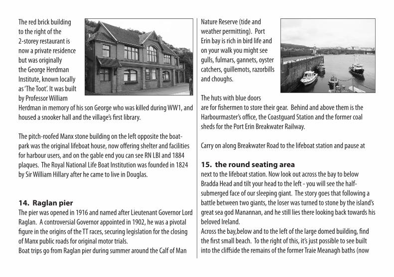
The red brick building to the right of the 2-storey restaurant is now a private residence but was originally the George Herdman Institute, known locally as ‘The Toot’. It was built by Professor William Herdman in memory of his son George who was killed during WW1, and housed a snooker hall and the village’s first library.
The pitch-roofed Manx stone building on the left opposite the boat-park was the original lifeboat house, now offering shelter and facilities for harbour users, and on the gable end you can see RN LBI and 1884 plaques. The Royal National Life Boat Institution was founded in 1824 by Sir William Hillary after he came to live in Douglas.
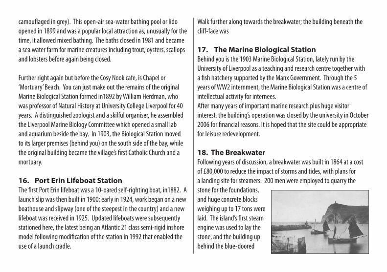
14. Raglan pierThe pier was opened in 1916 and named after Lieutenant Governor Lord Raglan. A controversial Governor appointed in 1902, he was a pivotal figure in the origins of the TT races, securing legislation for the closing of Manx public roads for original motor trials.Boat trips go from Raglan pier during summer around the Calf of Man
Nature Reserve (tide and weather permitting). Port Erin bay is rich in bird life and on your walk you might see gulls, fulmars, gannets, oyster catchers, guillemots, razorbills and choughs.
The huts with blue doors are for fishermen to store their gear. Behind and above them is the Harbourmaster’s office, the Coastguard Station and the former coal sheds for the Port Erin Breakwater Railway.
Carry on along Breakwater Road to the lifeboat station and pause at
15. the round seating areanext to the lifeboat station. Now look out across the bay to below Bradda Head and tilt your head to the left - you will see the half-submerged face of our sleeping giant. The story goes that following a battle between two giants, the loser was turned to stone by the island’s great sea god Manannan, and he still lies there looking back towards his beloved Ireland.Across the bay,below and to the left of the large domed building, find the first small beach. To the right of this, it’s just possible to see built into the cliffside the remains of the former Traie Meanagh baths (now
camouflaged in grey). This open-air sea-water bathing pool or lido opened in 1899 and was a popular local attraction as, unusually for the time, it allowed mixed bathing. The baths closed in 1981 and became a sea water farm for marine creatures including trout, oysters, scallops and lobsters before again being closed.
Further right again but before the Cosy Nook cafe, is Chapel or ‘Mortuary’ Beach. You can just make out the remains of the original Marine Biological Station formed in1892 by William Herdman, who was professor of Natural History at University College Liverpool for 40 years. A distinguished zoologist and a skilful organiser, he assembled the Liverpool Marine Biology Committee which opened a small lab and aquarium beside the bay. In 1903, the Biological Station moved to its larger premises (behind you) on the south side of the bay, while the original building became the village’s first Catholic Church and a mortuary.
16. Port Erin Lifeboat Station The first Port Erin lifeboat was a 10-oared self-righting boat, in1882. A launch slip was then built in 1900; early in 1924, work began on a new boathouse and slipway (one of the steepest in the country) and a new lifeboat was received in 1925. Updated lifeboats were subsequently stationed here, the latest being an Atlantic 21 class semi-rigid inshore model following modification of the station in 1992 that enabled the use of a launch cradle.
Walk further along towards the breakwater; the building beneath the cliff-face was
17. The Marine Biological StationBehind you is the 1903 Marine Biological Station, lately run by the University of Liverpool as a teaching and research centre together with a fish hatchery supported by the Manx Government. Through the 5 years of WW2 internment, the Marine Biological Station was a centre of intellectual activity for internees. After many years of important marine research plus huge visitor interest, the building’s operation was closed by the university in October 2006 for financial reasons. It is hoped that the site could be appropriate for leisure redevelopment.
18. The BreakwaterFollowing years of discussion, a breakwater was built in 1864 at a cost of £80,000 to reduce the impact of storms and tides, with plans for a landing site for steamers. 200 men were employed to quarry the stone for the foundations, and huge concrete blocks weighing up to 17 tons were laid. The island’s first steam engine was used to lay the stone, and the building up behind the blue-doored
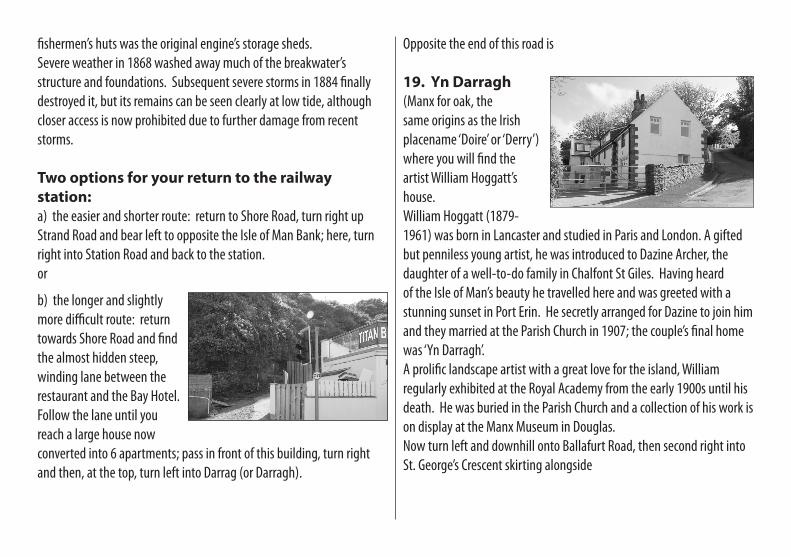
fishermen’s huts was the original engine’s storage sheds.Severe weather in 1868 washed away much of the breakwater’s structure and foundations. Subsequent severe storms in 1884 finally destroyed it, but its remains can be seen clearly at low tide, although closer access is now prohibited due to further damage from recent storms.
Two options for your return to the railway station:a) the easier and shorter route: return to Shore Road, turn right up Strand Road and bear left to opposite the Isle of Man Bank; here, turn right into Station Road and back to the station. or
b) the longer and slightly more difficult route: return towards Shore Road and find the almost hidden steep, winding lane between the restaurant and the Bay Hotel. Follow the lane until you reach a large house now converted into 6 apartments; pass in front of this building, turn right and then, at the top, turn left into Darrag (or Darragh).
Opposite the end of this road is
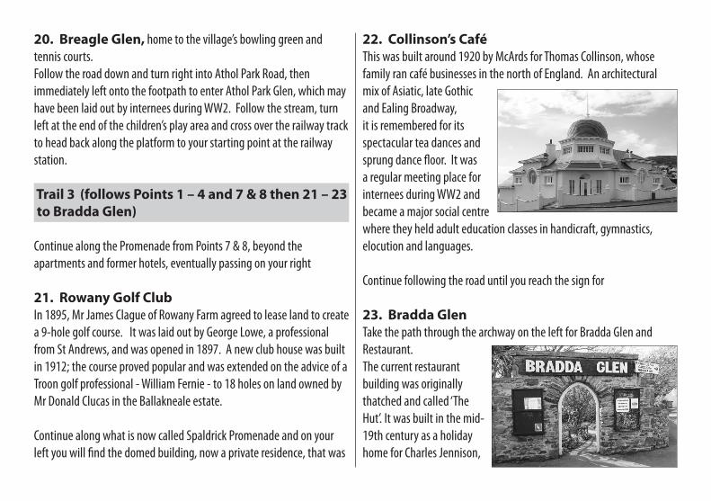
19. Yn Darragh (Manx for oak, the same origins as the Irish placename ‘Doire’ or ‘Derry’) where you will find the artist William Hoggatt’s house.William Hoggatt (1879-1961) was born in Lancaster and studied in Paris and London. A gifted but penniless young artist, he was introduced to Dazine Archer, the daughter of a well-to-do family in Chalfont St Giles. Having heard of the Isle of Man’s beauty he travelled here and was greeted with a stunning sunset in Port Erin. He secretly arranged for Dazine to join him and they married at the Parish Church in 1907; the couple’s final home was ‘Yn Darragh’. A prolific landscape artist with a great love for the island, William regularly exhibited at the Royal Academy from the early 1900s until his death. He was buried in the Parish Church and a collection of his work is on display at the Manx Museum in Douglas.Now turn left and downhill onto Ballafurt Road, then second right into St. George’s Crescent skirting alongside
20. Breagle Glen, home to the village’s bowling green and tennis courts. Follow the road down and turn right into Athol Park Road, then immediately left onto the footpath to enter Athol Park Glen, which may have been laid out by internees during WW2. Follow the stream, turn left at the end of the children’s play area and cross over the railway track to head back along the platform to your starting point at the railway station.
Trail 3 (follows Points 1 – 4 and 7 & 8 then 21 – 23 to Bradda Glen)
Continue along the Promenade from Points 7 & 8, beyond the apartments and former hotels, eventually passing on your right
21. Rowany Golf ClubIn 1895, Mr James Clague of Rowany Farm agreed to lease land to create a 9-hole golf course. It was laid out by George Lowe, a professional from St Andrews, and was opened in 1897. A new club house was built in 1912; the course proved popular and was extended on the advice of a Troon golf professional - William Fernie - to 18 holes on land owned by Mr Donald Clucas in the Ballakneale estate.
Continue along what is now called Spaldrick Promenade and on your left you will find the domed building, now a private residence, that was
22. Collinson’s CaféThis was built around 1920 by McArds for Thomas Collinson, whose family ran café businesses in the north of England. An architectural mix of Asiatic, late Gothic and Ealing Broadway, it is remembered for its spectacular tea dances and sprung dance floor. It was a regular meeting place for internees during WW2 and became a major social centre where they held adult education classes in handicraft, gymnastics, elocution and languages.
Continue following the road until you reach the sign for
23. Bradda GlenTake the path through the archway on the left for Bradda Glen and Restaurant. The current restaurant building was originally thatched and called ‘The Hut’. It was built in the mid-19th century as a holiday home for Charles Jennison,
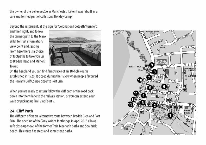
the owner of the Bellevue Zoo in Manchester. Later it was rebuilt as a café and formed part of Collinson’s Holiday Camp.
Beyond the restaurant, at the sign for “Coronation Footpath” turn left and then right, and follow the tarmac path to the Manx Wildlife Trust information/view point and seating. From here there is a choice of footpaths to take you up to Bradda Head and Milner’s Tower. On the headland you can find faint traces of an 18-hole course established in 1920. It closed during the 1950s when people favoured the Rowany Golf Course closer to Port Erin.
When you are ready to return follow the cliff path or the road back down into the village to the railway station, or you can extend your walk by picking up Trail 2 at Point 9.
24. Cliff PathThe cliff path offers an alternative route between Bradda Glen and Port Erin. The opening of the Tony Wright footbridge in April 2015 allows safe close-up views of the former Traie Meanagh baths and Spaldrick beach. This route has steps and some steep paths.
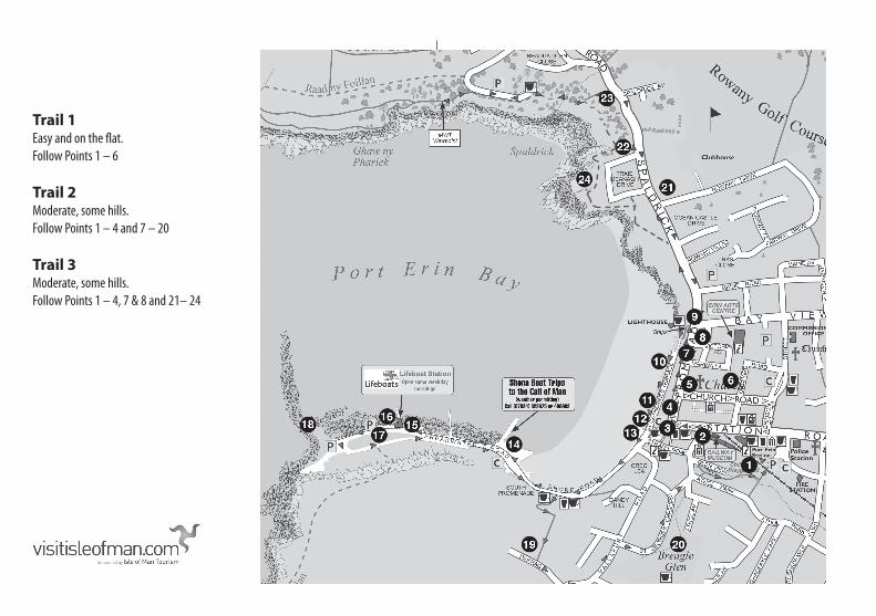
Trail 1 Easy and on the flat. Follow Points 1 – 6
Trail 2 Moderate, some hills. Follow Points 1 – 4 and 7 – 20
Trail 3 Moderate, some hills. Follow Points 1 – 4, 7 & 8 and 21– 24