ward area profile tuffley - home - gloucester city council and property/ward... · strengths access...
TRANSCRIPT

Ward Area Profile Tuffley
Spring 2013


Ward Area Profile: Tuffley
1
Contents Section A: Overview Ward Councillors Summary S.W.O.T
Appendix 1: Technical Information 1. Section B: Physical Character 1.1 Location 1.2 Historical Development 1.3 Character of the Area 1.4 Hierarchy of Routes
2. Section C: Demographics 2.1 Population 2.2 Age 2.3 Ethnicity 2.4 Gender 2.5 Housing Tenure 2.6 Profile of Housing Stock Property Size Bedrooms Council Tax Housing Need 2.6 Energy Efficiency of Stock Fuel Poverty
3. Section D: Community 3.1 Healthcare 3.2 Libraries 3.3 Places of Worship 3.4 Community Facilities 3.5 Education Facilities 3.6 Leisure Facilities 3.7 Cultural Facilities 3.8 Community Groups and Services
4. Section E: Deprivation 4.1 Deprivation Table 4.2 Headlines 4.3 Children and Young People 4.4 Health and Wellbeing 4.5 Crime

Ward Area Profile: Tuffley
2
4.6 Car Ownership
5. Section F: Economics 5.1 Employment 5.2 Average Household Income 5.3 Educational Achievement 5.4 Retail 5.5 Public Transport
6. Section G: Land Use Issues 6.1 Public Open Space 6.2 Green Infrastructure 6.3 Water 6.4 Sustainability 6.5 Conservation
7. Section H: Previous Issues
Appendix 1: Technical Information

Ward Area Profile: Tuffley
3
Section A: Overview
Ward Councillors
Councillor Gerald Dee 13 Firwood Drive Tuffley Gloucester GL4 0AB Tel: 01452 301949 [email protected] Councillor Colin Organ 337 Stroud Road Gloucester GL4 0BA Mobile: 07767350003 Email: [email protected]
Summary
Tuffley ward is a residential suburb of Gloucester and is very much seen as part of a wider area including the ward of Grange and to some extent Podsmead. Tuffley has its own primary school and faith based secondary school. There is a small parade of shops and an area of allotments. The ward does have some deprivation issues, most noticeably relating to low household income, high benefit claimants, issues relating to children and young people and also crime. These appear to be in pockets rather than across the ward as a whole. The ward itself is lacking in public open space, play equipment and sports provisions. It does however have access to Robinswood Hill Country Park. The park offers walks, wildlife and impressive long distances views. Within the park is an old quarry that is designated as a Site of Special Scientific Interest. The ward also benefits from good public transport links to the City centre and to the neighbouring district of Stroud.

Ward Area Profile: Tuffley
4
S.W.O.T.
Strengths
Access to Robinswood Hill Country Park
Access to Tuffley Community Association
Regular bus services with links to city and Stroud
Allotments
Lower than average numbers of burglary victims, theft victims and serious road traffic collisions.
High proportion of owner occupation
Public art on Robinswood Hill
Views and aspect over the Stroud Valley.
Low number of people in fuel poverty.
Weaknesses
Low number of private rented homes
Pockets of deprivation
Serious short fall of public open space
Serious short fall of play equipment
Serious short fall of playing pitches
High levels of some crimes
Low household income
Opportunities
Improving signage and access to Robinswood Hill and Randwick Park?
Development of private housing for rent taken over further developments of affordable housing
Making more of Robinswood Hill – tourism, promotion, events, café?
Threats
Developments in Stroud District and pressure that would place on infrastructure and services?
Protecting Robinswood Hill from development

Ward Area Profile: Tuffley
5
Appendix 1: Technical Information
The following data and information was collected to inform the SWOT table and build a clear picture of the issues and opportunities in the ward.
Section B: Physical Character
1.1 Location
Figure 1: Location Map of Tuffley

Ward Area Profile: Tuffley
6
Tuffley is a residential suburb located to the south of the City. It shares boundaries with the wards
of Grange, Podsmead, Moreland and Matson and Robinswood. The ward also shares a boundary
with the neighbouring district of Stroud. The eastern boundary of the ward wraps around
Robinswood Hill. The western boundary is marked predominately by the railway line. The ward
takes in a parcel of housing to the west of the railway line. This includes Tuffley Lane, Epney
Road and Cole Avenue. The northern boundary extends to Selwyn Road.
The people of Tuffley and Grange very much share services, facilities and operate beyond the
ward boundaries.
1.2 Historical Development
Today Tuffley ward is predominantly an area of suburban residential development lying between
Robsinwood Hill to the east and the west coast main line. Of all the wards in Gloucester Tuffley
has seen some of the most profound changes since the 19th century.
The first edition ordnance Survey map of 1886 shows that, just 150 years ago, the ward was
almost entirely rural in character. The largest settled area is shown at Tuffley Court – which is a
manor house with associated hamlet. Tuffley Court almost certainly has medieval origins and is
likely to have developed from an estate mentioned in the Domesday survey of 1086.
More recent settlement is visible on the map northwards along the Stroud Road with a number of
large houses such as Tuffley Lodge and Elmhurst. Two small farms are also recorded within the
ward. The landscape during this time was a mix of open farmland and a considerable number of
orchards.
The Ordnance Survey map of 1923 shows a largely unchanged ward except for a substantial
increase of residential development along the Stroud Road and to the east of Tuffley Court. By
1945 the north of the ward had been entirely given over to residential development with large
stretches of semi-detached housing either side of Finlay Road. The most extensive development
appears to have taken place between 1945 and 1955 with almost the whole of the ward given over
to sub urban development. Rather sadly the historic core around Tuffley Court appears to have
been completely destroyed as do a number of smaller outlying farms. Essentially an entire
medieval and post medieval landscape along with associated buildings has been almost entirely
lost. The only real surviving elements being the Stroud Road which is likely to date to the medieval
period.

Ward Area Profile: Tuffley
7
Figure 2: Historic Map of Tuffley circa 1902
Figure 3: Map of Tuffley
Ward Area Profile: Tuffley
8
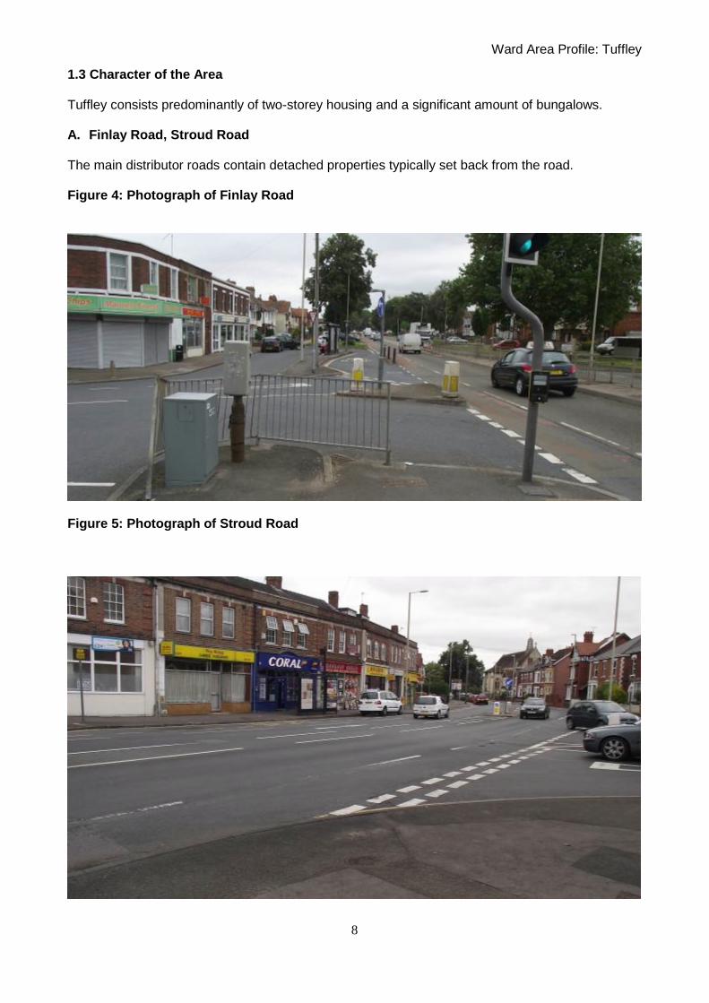
1.3 Character of the Area Tuffley consists predominantly of two-storey housing and a significant amount of bungalows.
A. Finlay Road, Stroud Road The main distributor roads contain detached properties typically set back from the road. Figure 4: Photograph of Finlay Road
Figure 5: Photograph of Stroud Road

Ward Area Profile: Tuffley
9
B. North west residential parcel – Longney Road, Falfield Road area. These roads are mostly arranged in semi-detached pairs. A number of the properties in Longney Road have the original prefabricated sheeting to the upper floors. Properties in Falfield Road and Slimbridge Road are also typically arranged in pairs but are finished in brick rather than render or cladding. Figure 6: Photograph of Falfield Road
C. Residential area around Robinswood Hill - Fox Elms Road, Woods Orchard Road area
In this area there are some Victorian properties and many late 20th century infill detached properties. The properties have been developed individually or in small pockets. Many of the properties have been designed and orientated to make the most of the view from this elevated position along the edge of the hillside.

Ward Area Profile: Tuffley
10
Figure 7: Photograph of Fox Elms Road

Ward Area Profile: Tuffley
11
D. Other housing in Tuffley There are many different housing types in Tuffley, however they are almost all two storey or bungalows. The housing appears to have been constructed predominantly between 1950 – 1990. Figure 8: Photograph of Gurney Avenue – houses and bungalows
Figure 9: Photograph of Bybrook Gardens

Ward Area Profile: Tuffley
12
Figure 10: Photographs of Grange Road – views to open countryside
1.4 Hierarchy of Routes
The main distributor roads into Tuffley are Finlay Road, Stroud Road, Southern Avenue and Cole Avenue. Internally secondary routes such as Tuffley Lane and Grange Road feed the residential streets.
Ward Area Profile: Tuffley
13
Section C: Demographics
2.1 Population
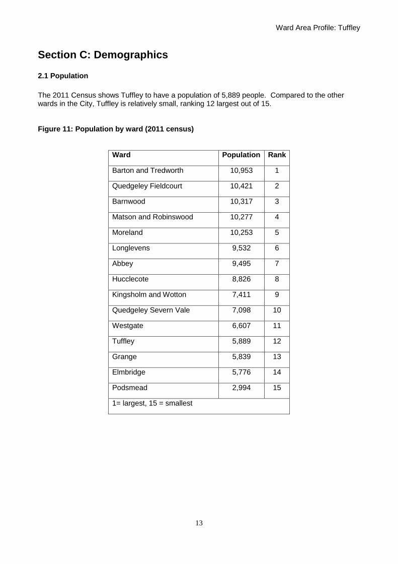
The 2011 Census shows Tuffley to have a population of 5,889 people. Compared to the other wards in the City, Tuffley is relatively small, ranking 12 largest out of 15. Figure 11: Population by ward (2011 census)
Ward Population Rank
Barton and Tredworth 10,953 1
Quedgeley Fieldcourt 10,421 2
Barnwood 10,317 3
Matson and Robinswood 10,277 4
Moreland 10,253 5
Longlevens 9,532 6
Abbey 9,495 7
Hucclecote 8,826 8
Kingsholm and Wotton 7,411 9
Quedgeley Severn Vale 7,098 10
Westgate 6,607 11
Tuffley 5,889 12
Grange 5,839 13
Elmbridge 5,776 14
Podsmead 2,994 15
1= largest, 15 = smallest
Ward Area Profile: Tuffley
14
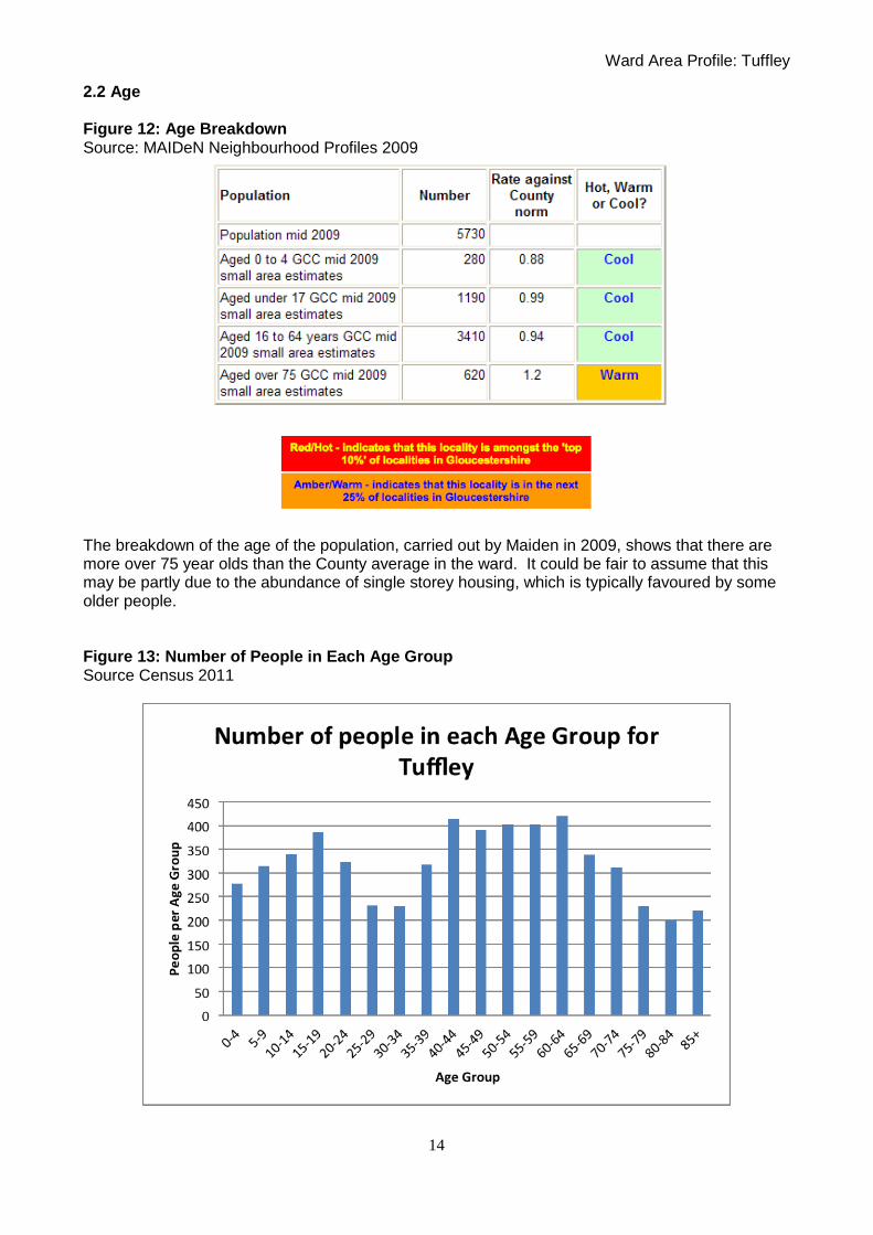
2.2 Age Figure 12: Age Breakdown Source: MAIDeN Neighbourhood Profiles 2009
The breakdown of the age of the population, carried out by Maiden in 2009, shows that there are more over 75 year olds than the County average in the ward. It could be fair to assume that this may be partly due to the abundance of single storey housing, which is typically favoured by some older people. Figure 13: Number of People in Each Age Group Source Census 2011

Ward Area Profile: Tuffley
15
2.3 Ethnicity Figure 14: Table of Ethnicity Source: Gloucestershire County Council - Ethnicity in Gloucestershire 2006 - uses four ethnic groupings: White British; White Minorities (White Irish/ White Other); BME (“Non-White” Groups: Mixed Race, Asian or Asian British, Black or Black British, Chinese, Other), and Ethnic Minorities (BME plus White Minorities: in other words all non-White British people).
The population of the ward is predominantly White British. Ethnic Minorities make up 6.2% of the total population.
2.4 Gender The breakdown of population into age bands and gender shows that there are a greater number of males aged 15-24 than females. In accordance with the Maiden data there are a significant number of people aged over 80 years. Of these people there are many more females than males. Whilst this to some extent reflects national life expectancy trends, it also reflects the fact that the ward has a number of elderly care facilities.
Ward Area Profile: Tuffley
16
Figure 15: Breakdown of Population Cohorts by Sex (Source: 2010 ONS)
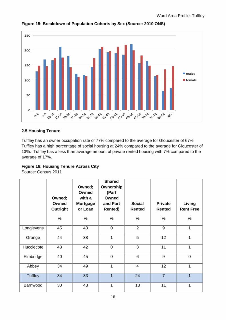
2.5 Housing Tenure Tuffley has an owner occupation rate of 77% compared to the average for Gloucester of 67%.
Tuffley has a high percentage of social housing at 24% compared to the average for Gloucester of
13%. Tuffley has a less than average amount of private rented housing with 7% compared to the
average of 17%.
Figure 16: Housing Tenure Across City
Source: Census 2011
Owned;
Owned
Outright
%
Owned;
Owned
with a
Mortgage
or Loan
%
Shared
Ownership
(Part
Owned
and Part
Rented)
%
Social
Rented
%
Private
Rented
%
Living
Rent Free
%
Longlevens 45 43 0 2 9 1
Grange 44 38 1 5 12 1
Hucclecote 43 42 0 3 11 1
Elmbridge 40 45 0 6 9 0
Abbey 34 49 1 4 12 1
Tuffley 34 33 1 24 7 1
Barnwood 30 43 1 13 11 1

Ward Area Profile: Tuffley
17
Barton and
Tredworth 24 30 1 12 32 2
Kingsholm
and Wotton 23 24 1 16 34 1
Matson and
Robinswood 23 30 0 38 8 1
Moreland 22 40 0 14 23 1
Podsmead 22 26 0 42 9 1
Quedgeley
Fieldcourt 19 46 4 11 19 1
Westgate 19 20 2 19 38 1
Quedgeley
Severn Vale 18 57 1 4 20 1
Gloucester 29 38 1 13 17 1
South West 35 32 1 13 17 1
England 31 33 1 18 17 1
Figure 17: Pie Chart showing Tenure Split within Ward

Ward Area Profile: Tuffley
18
Figure 18: Chart Showing Tenure Split by Ward in Gloucester (2011)
2.6 Profile of Housing Stock
Property Size
Tuffley has a higher than average percentage of Houses and Bungalows at 91% compared to the
average for Gloucester at 83%. In turn, Tuffley has a lower than average percentage of Flats at
9% compared to the district average of 16%.
Figure 19: Property Size
Source: Census 2011
House or
Bungalow
%
Flat
%
Caravan or
Mobile Home
%
Shared
Dwelling
%
Longlevens 96 3 0 0
Abbey 95 5 0 0
Elmbridge 93 6 0 0
Hucclecote 92 7 1 0
Barnwood 92 8 0 0
Grange 92 6 3 0
Tuffley 91 9 0 0
Quedgeley 91 9 0 0

Ward Area Profile: Tuffley
19
Severn Vale
Quedgeley
Fieldcourt 89 9 2 0
Moreland 86 13 0 1
Barton and
Tredworth 80 20 0 1
Podsmead 78 22 0 0
Matson and
Robinswood 77 23 0 0
Kingsholm and
Wotton 52 47 0 1
Westgate 40 57 1 3
Gloucester 83 16 0 0
South West 81 18 1 0
England 78 21 0 0
Bedrooms
Tuffley has a spread of properties similar to the average for Gloucester. 9% of properties have
one bedroom compared to 11% in Gloucester; 48% of properties have three bedrooms compared
to 43% for Gloucester. The remaining sized properties are in proportion to the City.
Figure 20: Bedroom Numbers
Source: Census 2011
1 Bedroom
%
2 Bedrooms
%
3 Bedrooms
%
4 Bedrooms
%
5 or More
Bedrooms
%
Abbey 5 22 42 28 3
Barnwood 6 16 46 26 6
Barton and
Tredworth 15 32 42 8 3
Elmbridge 3 18 57 18 4
Grange 4 35 54 5 1
Hucclecote 5 25 49 19 2

Ward Area Profile: Tuffley
20
Kingsholm
and Wotton 26 32 25 11 5
Longlevens 5 20 51 22 3
Matson and
Robinswood 15 30 46 8 2
Moreland 9 26 52 9 4
Podsmead 20 23 46 7 4
Quedgeley
Fieldcourt 7 33 38 19 3
Quedgeley
Severn Vale 8 30 39 21 2
Tuffley 9 27 48 13 3
Westgate 38 29 19 9 5
Gloucester 11 27 43 15 3
South West 11 27 40 16 5
England 12 28 41 14 5
Council Tax
The spread in Council Tax Bands in Tuffley is similar to the City overall despite a leaning towards
Houses and Bungalows and higher percentage of social housing.
Figure 21: Council Tax Bands
Source: Census 2011
Band A
%
Band B
%
Band C
%
Band D
%
Band E
%
Band F
%
Band G
%
Band H
%
Abbey 5 30 30 23 12 2 0 0
Barnwood 33 17 17 13 17 3 0 0
Barton and
Tredworth 67 29 3 0 0 0 0 0
Elmbridge 8 25 43 12 7 2 1 0
Grange 10 59 29 2 0 0 0 0

Ward Area Profile: Tuffley
21
Hucclecote 10 15 50 13 10 3 0 0
Kingsholm
and Wotton 41 31 13 7 5 2 1 0
Longlevens 5 12 52 18 11 2 0 0
Matson and
Robinswood 54 23 15 5 2 0 0 0
Moreland 48 37 9 3 1 1 1 0
Podsmead 46 26 16 7 2 2 0 0
Quedgeley
Fieldcourt 13 44 23 12 7 1 0 0
Quedgeley
Severn Vale 9 32 27 20 10 1 0 0
Tuffley 26 30 23 12 5 3 1 0
Westgate
Gloucester 30 28 24 10 6 2 0 0
South West 18 25 23 16 11 5 3 0
England 25 20 22 15 9 5 4 1
Housing Need
The Fordham Research Gloucestershire Household Survey of Housing Need (2009) identifies that
there are 3.8% of households in unsuitable housing in the South Central region. This region
includes Podsmead, Grange, Tuffley and Matson and Robinswood.
Figure 22: Unsuitable Housing and Housing Need

Ward Area Profile: Tuffley
22
Summary
Tuffley as a higher percentage of owner occupiers of houses and bungalows than Gloucester
overall. Tuffley also has a high percentage of social housing and a low percentage of private
rented housing. The development of private housing for rent should be taken over further
development of affordable housing in order to move towards a balance for the City overall.
2.7 Energy Efficiency of Stock
The SAP rating is based on each dwelling‟s energy cost per square metre and is calculated using
a simplified form of the Standard Assessment Procedure. The energy costs take into account the
costs of space and water heating, ventilation and lighting, less any cost savings from energy
generation technologies. The rating is expressed on a scale of 1-100 where a dwelling with a
rating of 1 has poor energy efficiency (high costs) and a dwelling with a rating of 100 represents a
completely energy efficient dwelling (zero net energy costs per year). Carbon dioxide (CO2)
emissions are derived from space heating, water heating, ventilation, lighting, less any emissions
saved by energy generation and are measured in tonnes per year. An Energy Efficiency Rating
(EER) is presented in bands from A-G for an Energy Performance Certificate, where a Band A
rating represents low energy costs (the most efficient band) and Band G rating represents high
energy costs (the least efficient band.)
Band A: 92-100 Band B: 81-91 Band C: 69-80 Band D: 55-68 Band E: 39-54 Band F: 21-38 Band G: 1-20
The City Council‟s Housing SAP (Standard Assessment Procedure) rating data collated in 2005.
shows the average SAP score for City Council stock in Tuffley to be 68 which falls into a Band D
rating.
The 2011 SAP rating for private homes across the whole City was 65 Band D, which is significantly
better than the national average of 51 Band E.
Fuel Poverty
A household is deemed to be in Fuel Poverty if they spend more than 10% of their income of
heating their home; the table below shows the percentage of households who are defined as being
in fuel poverty. 4.9% of households in Tuffley are in fuel poverty, which is lower than the local
authority average of 5.5%.
Figure 23: Fuel Poverty
Source: Fuel Poverty Indicators – Centre for Sustainable Energy
Ward On Full Income (Equivalised)
Longlevens 4.0%

Ward Area Profile: Tuffley
23
Abbey 4.1%
Hucclecote 4.1%
Quedgeley Severn Vale 4.1%
Elmbridge 4.8%
Tuffley 4.9%
Grange 5.0%
Quedgeley Fieldcourt 5.0%
Barnwood 5.2%
Podsmead 5.5%
Matson and Robinswood 5.7%
Kingsholm and Wotton 6.3%
Westgate 7.0%
Moreland 7.2%
Barton and Tredworth 8.9%
Total 5.5%

Ward Area Profile: Tuffley
24
3. Section D: Community
3.1 Healthcare
There are two doctors surgery within the ward: Dr Evans MR and Partners, 10 Tuffley Lane Gloucester GL4 0DT Tel: 01452 525660 St Lukes 10 Tuffley Lane Gloucester GL4 0DT Tel: 01453 763755
3.2 Libraries There are no libraries within the ward, the closest ones are located in Grange ward on Windsor Drive, in the City Centre and at Matson and Robinswood. 3.3 Places of Worship There are two places of worship in the ward, St. Barnabas Church of England on Stroud Road and Trinity Baptist Church on Finlay Road. Both churches offer family worship on a Sunday morning as well as groups and activities throughout the week for the wider community. 3.4 Community Facilities
The following information is taken from the Community Facilities Audit Autumn 2012.
A community facility is defined in the Audit as “Any building available for hire by any member of the community for the purposes of community activities.”
Uses may include parent and toddler groups, community meetings, community events, worship, sports teams, keep fit classes, training and adult education, social gatherings, celebrations and the meeting of any local group or club that is open to all members of the community.
The recommended level of community facilities is 0.44 facilities to 1000 population. This figure is taken from “Shaping Neighbourhood: Health, Sustainability, Vitality” Guise, Barton & Grant (2002).
Tuffley has 0.55 facilities per 1000 population, which is just above the recommended amount of 0.44.
Figure 24: Table showing the number of community facilities by ward
Ward
Population Facilities open to
all
Facilities per 000
population
Difference to recommend 0.44 per 000
Percentage of recommended 0.44 per 000
achieved
1 Abbey 9391 3 0.319 -0.121 73%
2 Barnwood 10102 8 0.792 0.352 180%

Ward Area Profile: Tuffley
25
3 Barton and Tredworth 11287 8 0.709 0.269 161%
4 Elmbridge 5650 5 0.885 0.445 201%
5 Grange 5621 5 0.890 0.450 202%
6 Hucclecote 8539 8 0.937 0.497 213%
7 Kingsholm and Wotton 7032 7 0.995 0.555 226%
8 Longlevens 9567 13 1.359 0.919 309%
9 Matson and Robinswood 10323 8 0.775 0.335 176%
10 Moreland 10286 4 0.389 -0.051 88%
11 Podsmead 2890 4 1.384 0.944 315%
12 Quedgeley Fieldcourt 9129 6 0.657 0.217 149%
13 Quedgeley Severn Vale 6908 0 0.000 -0.440 0%
14 Tuffley 5751 3 0.522 0.082 119%
15 Westgate 5964 13 2.180 1.740 495%
City Totals 118440 95 0.802 0.362 182%
Figure 25: Chart showing difference to recommended 0.44 facilities per thousand population. (0=0.44)
The three community facilities identified are: Robinswood Hill Social Club, St Peter‟s Catholic High School and St Barnabas Church Hall. The Church Hall hosts a variety of regular events including dance school, painting group, tea dances, Women‟s Institute, lunch club, Brownies, Beavers, Cubs, Scouts, toddler group and an antiques auction four times a year.

Ward Area Profile: Tuffley
26
3.5 Education Facilities The ward has two schools including one primary school and a large secondary school. Both schools are located in the south of the ward. Tuffley Primary School Evenlode Road Tuffley Gloucester GL4 0JY St Peters Roman Catholic High School Stroud Road Gloucester GL4 0DD 3.6 Leisure Facilities Entrances into Robinswood Hill Country Park are located within the ward. The park offers walks, wildlife and long distances views. Within the park is an old quarry that is designated as a Site of Special Scientific Interest. The park is managed by Gloucester City Council‟s Countryside Unit. 3.7 Cultural Facilities There are no cultural facilities located within the ward.
3.8 Community Groups and Services The Friends of Robinswood Hill is an independent society who works closely with the Countryside Unit to ensure the park is cared for. Tuffley Community Association operates from Tuffley Community Centre, Windsor Drive, Grange. Although not located in the ward, the Community Association is open to people living in the wards of Tuffley, Podsmead and Grange. The Association offers a number of social, educational and recreational activities.

Ward Area Profile: Tuffley
27
Section E: Deprivation 4.1 Deprivation Table
HOT indicates that this locality is amongst the „top 10%‟ (or „bottom 10% marked with *) of localities in Gloucestershire. WARM indicates that this locality is in the next 25% of localities in Gloucestershire.
Source MAIDeN Number Hot,
Warm or Cool
Health Social Work assessments 2011 5 COOL
Mental Health assessments 2011 40 WARM
Accident Admissions 2012 355 WARM
Children and Young People Accident Admissions of under 5‟s 2012 25 WARM
Accident Admissions of under 17‟s 2012 60 COOL
Children in need 2011 45 WARM
Crime victims under 20 years old 2010-11 45 WARM
Lone parent benefit claimants August 2008 90 HOT
Key stage 4 - Pupils not achieving 5+ A*-C grades inc English * maths 2012 30 WARM
Free School Meals - Pupils eligible 2012 195 HOT
English as an Additional Language - pupils of school age whose first language is known
760 HOT
Crime Victims of crime (all) 2010-11 330 WARM
Anti Social Behaviour Incidents recorded by the Police 2010-11 270 WARM
Theft victims 2010-11 125 COOL
Violence victims 2010-11 80 WARM
Burglary victims 2010-11 45 COOL
Hate Crime/incidents 2010-11 15 WARM
Serious and Fatal Road Traffic Collisions 2007-10 5 COOL
Criminal damage victims 2010-11 60 WARM
Arson recorded by Fire and Rescue 2008-11 35 WARM
Economy Mean household income 2007 £k* 30.595 WARM
Working-age benefit claimants Aug 2008 510 HOT
Job seeker claimants Aug 2008 70 HOT
Incapacity Benefit claimants 2008 225 HOT
Lone parent benefit claimants Aug 2008 90 HOT
Carer claimants Aug 2008 45 HOT
Disabled claimants Aug 2008 25 WARM
Households with broadband internet 2008* 2094 COOL

Ward Area Profile: Tuffley
28
4.2 Headlines The data shows that there are issues of deprivation within the ward. The data suggests that this deprivation may well be in pockets, as while some data scores HOT, there are also many WARM and COOL indicators as well. 4.3 Children and Young People The ward has over double the County average of Pupils eligible for Free School Meals. There are also high numbers of Lone parent benefit claimants. A higher number of children than the County average do not achieve 5 or more A* - C grades at GCSEs (including maths and English). There are also higher than the County average of Low birth weight babies and accident admissions of the under 5‟s, and children in need. Crime victims under 20 years old are also higher than the County average. 4.4 Health and Wellbeing The following maps are taken from “Gloucester Healthy Living – Gloucester Area Health Profile
2009-2010 NHS Gloucestershire”.
Figure 26: Gloucester Existing Health Problems

Ward Area Profile: Tuffley
29
The map above shows existing health issues, such as people with angina, those that have suffered
a heart attack, new cases of diabetes, high blood pressure and high cholesterol.
Figure 27: Gloucester Future Health Problems
The map above shows potential future health problems in the city. This is created by taking into
account the indicators for potential ill-health. These indicators include: high numbers of smokers
and obese people, diet (few people eating sufficient amounts of fruit and vegetables), and where
the consumption of both fast food and sugary drinks is above average
The maps show that there are expected to be significant improvements in health for the majority of
the ward. Two pockets remain where health issues are expected to remain at a similar rate.
4.5 Crime There are lower than average numbers of burglary victims, theft victims and serious road traffic collisions. Unfortunately there are a higher than County average number of Young offender interventions, and victims of all crime.

Ward Area Profile: Tuffley
30
4.6 Car Ownership Car ownership in the ward is high. This is as expected in a suburban area. Figure 28: Car Ownership
Ward Area Profile: Tuffley
31
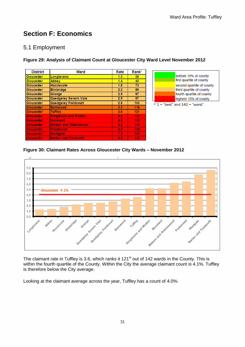
Section F: Economics 5.1 Employment Figure 29: Analysis of Claimant Count at Gloucester City Ward Level November 2012
Figure 30: Claimant Rates Across Gloucester City Wards – November 2012
The claimant rate in Tuffley is 3.6, which ranks it 121st out of 142 wards in the County. This is within the fourth quartile of the County. Within the City the average claimant count is 4.1%. Tuffley is therefore below the City average.
Looking at the claimant average across the year, Tuffley has a count of 4.0%.

Ward Area Profile: Tuffley
32
Figure 31: Claimant Rate Annual Average 2012
Rate of
claimant
count
Claimant
Rate
Average
for Year
2012
Ward Jan-12 Feb-
12
Mar-
12
Apr-
12
May-
12
Jun-
12
Jul-
12
Aug-
12
Sep-
12
Oct-
12
Nov-
12
Dec-
12 Average
Longlevens 1.4 1.2 1.2 1.3 1.3 1.3 1.2 1.3 1.3 1.1 1.3 1.1 1.3
Abbey 1.8 1.9 1.8 1.6 1.6 1.6 1.5 1.5 1.6 1.5 1.4 1.4 1.6
Hucclecote 1.8 1.9 1.9 1.7 1.7 1.7 1.7 1.7 1.8 1.7 1.8 1.7 1.8
Elmbridge 2.1 2.2 2.3 2.4 2.4 2.4 2.4 2.5 2.3 2.3 2.2 2.0 2.3
Quedgeley
Severn Vale 2.1 2.2 2.3 2.0 2.0 2.1 2.1 2.4 2.3 2.3 2.5 2.1 2.2
Grange 2.7 2.9 2.9 2.6 2.6 2.0 2.1 2.3 2.5 2.5 2.5 2.5 2.5
Barnwood 3.4 3.5 3.6 3.5 3.5 3.3 3.4 3.5 3.5 3.3 3.3 3.2 3.4
Quedgeley
Fieldcourt 3.5 3.4 3.2 3.2 3.2 3.1 2.9 3.0 3.1 3.0 2.8 2.6 3.1
Tuffley 4.3 4.5 4.5 4.2 4.2 4.0 4.1 4.1 3.8 3.6 3.6 3.3 4.0
Moreland 5.3 5.6 5.3 5.2 5.2 5.2 5.2 5.1 4.7 4.9 5.2 5.0 5.2
Kingsholm and
Wotton 5.4 5.8 5.4 5.6 5.6 5.6 5.7 5.5 5.4 5.1 5.2 5.0 5.4
Matson and
Robinswood 6.2 6.5 6.5 6.2 6.2 6.0 6.0 6.0 6.0 6.2 6.2 6.5 6.2
Podsmead 6.5 6.9 6.7 6.1 6.1 6.0 6.3 6.4 6.2 6.3 6.5 6.6 6.4
Barton and
Tredworth 7.7 8.3 8.3 8.1 8.1 8.1 8.1 8.5 8.4 8.6 8.6 8.7 8.3
Westgate 8.3 8.7 8.7 9.0 9.0 8.4 8.5 8.4 8.3 8.4 7.8 7.4 8.4
5.2 Average Household Income
The Maiden data shows a mean household income in 2007 of £30,595. More recent data from another source collated in 2012 shows the average household income to be £26,035. This would indicate a decrease in household income. The household income is now below the Gloucester City average and the UK average. Low income can affect health and wellbeing.

Ward Area Profile: Tuffley
33
Figure 32: Average Gross Household Income by ward in Gloucester 2010
5.3 Educational Achievement
In 2010/11, 55.9% of pupils living in the ward achieved of 5 or more GCSEs grades A*-C including English and maths. This is just below the UK national average of 58.2%. 77.9% of pupils achieved 5 or more GCSEs grades A*-C. This is above the UK national average is 68.4%.
Figure 33: GCSE Attainment for City by ward
Ward Area Profile: Tuffley
34
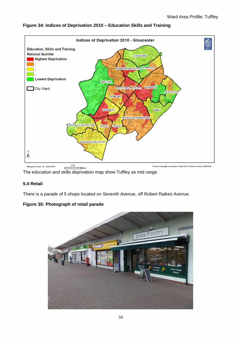
Figure 34: Indices of Deprivation 2010 – Education Skills and Training
The education and skills deprivation map show Tuffley as mid range.
5.4 Retail There is a parade of 5 shops located on Seventh Avenue, off Robert Raikes Avenue. Figure 35: Photograph of retail parade

Ward Area Profile: Tuffley
35
5.5 Public Transport The area is served by bus numbers 9, 7, 91 an 93 operated by Stagecoach. The buses provide links to the City centre and Stroud.

Ward Area Profile: Tuffley
36
Section G: Land Use Issues
6.1 Public Open Space
Tuffley ward is a residential ward of predominantly 20th century housing development, plus schools, some local shops and private farmland. Mid 2010 estimate is a population of 5,751. The open spaces in the ward were created as part of housing development, to provide space for formal and informal recreation or as a buffer to the mainline railway. Tuffley‟s open spaces are a mainly maintained as short mown grass with associated trees, shrubs and hedgerows. There is one allotments site in the ward. The east of the ward also meets the boundary of Robinswood Hill Country Park. In total, the ward has 7.02ha of open space, a provision of 1.22ha per 1000 population, which falls well short of the proposed open space standard of 2.8ha per 1000. St Peters High School allows some shared use of its pitches (and these form the sports pitch calculation below), but there are no other formal sports pitches provided on open space in the ward. Sports pitch provision therefore is 0.27ha per 1000, which falls seriously short of the proposed standard for playing pitch provision of 1.6ha per 1000. Pitches in the adjacent Grange and Podsmead wards help serve the severely deficient Tuffley ward. There is one play area in the ward, which equates to 0.01ha per 1000, which falls severely short of the proposed standard for formal play provision of 0.25ha per 1000.
Figure 36: Open Space in Tuffley

Ward Area Profile: Tuffley
37
Open Space Types
Type
A Parks and gardens
B Informal green space
C Allotments
D Countryside and natural spaces
E Green infrastructure
F Civic spaces
G Cemeteries
H Spaces for children and young people
I Amenity Green Space
J Sports provision

Ward Area Profile: Tuffley
38
Figure 37: Public Open Space in Tuffley

Ward Area Profile: Tuffley
39
Opportunities for improved provision Tuffley falls well short of the council‟s adopted standard for open space quantity, but there is currently little opportunity for the creation of new open space in the ward, so improvements in provision should concentrate on providing high quality park infrastructure and facilities on existing sites. Open spaces in adjacent wards, such as Robinswood Hill and Randwick Park also serve the residents of Tuffley, so ensuring there is good signage and safe access to these sites is also important. There is an opportunity to create a full, informal MUGA and improved children‟s and teenage play area at Tuffley Court open space. Further improving the allotment site in terms of secure fencing etc is also desirable. Other local priorities will be developed in consultation with the local community as part of the development of the Tuffley Ward Open Space Action Plan.

Ward Area Profile: Tuffley
40
6.2 Green Infrastructure
Figure 38: Natural Environment Map

Ward Area Profile: Tuffley
41
6.3 Water There are sections of two watercourses which run through Tuffley; the Whaddon brook and the Daniels brook both to the South of the Ward.
Whaddon brook
The section of the Whaddon brook which runs through Tuffley is classified as an Ordinary Watercourse and the City Council is the responsible Land Drainage Authority in addition to being a land owner along stretches of the watercourse.
Daniels brook
The Daniels brook forms the boundary with Stroud District Council to the South of the Ward and is classified as an Ordinary Watercourse and the City Council is the responsible Land Drainage Authority.
Flooding Issues
A number of properties off Grange Road were affected by flooding in 2007 due to a number of factors including:
Surface water pouring off fields adjacent to Grange Road,
Surface water run-off from Robinswood Hill and Stroud Road which converges on the Stroud Road/Grange Road junction before making its way down Grange Road
In order to reduce the risk of future issues works have been carried out including:
The installation of a bund and interceptor drain along a section of Grange Road
The clearance of the culverted section of the Whaddon brook from the Stroud Road culvert down to Bybrook Road
The clearance of the brook between Bybrook Road down to the rear of Bateman Close including the removal of a homemade trash screen
The installation of a trash on the upstream side of the Stroud Road culvert to prevent large items becoming wedges in the culvert

Ward Area Profile: Tuffley
42
Walk through inspections of the culvert between the rear of Bateman Close and Grange
Road which became blocked in 2007
6.4 Sustainability St Peters School has a 4kw wind turbine.
6.5 Conservation Whilst there are areas of period properties in the Tuffley ward which contribute to the character of the ward, there are no designated Conservation Areas. There are two listed buildings within the ward: No.333, Stroud Road Gr II Church of St Barnabas, Stroud Road Gr II* The descriptions can be found online at http://www.gloucester.gov.uk/Website/Spatial-Planning/Planning-listedbuildings-statutoryregister/ScheduleofListedBuildingsinGloucester.aspx There is one Building At Risk which is 333 Stroud Rd, information can be found on our Website.
The ward contains no scheduled monuments but does contain part of the Robinswood Hill Area of
Principal Archaeological Interest.

Ward Area Profile: Tuffley
43
7. Section H: Previous Issues
City Plan and City Vision Scope Consultation Summer 2011
Three Bridges Neighbourhood Partnership Meeting 18th May
- Concern was raised over the Kingsway urban extension; that it has not created a good or
attractive environment.
St. Peter‟s School Summer Fayre 2nd July 2011
- No comments received about Tuffley ward per se
Local Development Framework Site Allocation Preferred Options Document September
2006
Land South of Grange Road was identified in the 2005 Issues and Options Site Allocations
Document as a site for possible long term residential development on a phased basis.
The site was not carried forward into the Preferred Options Document owing to the significant level
of responses received relating to; loss of a green field site; impact on local services and
infrastructure; accessibility; traffic generation; the lack of need for new housing and impact on
views to and from Robinswood Hill.
2002 Second Deposit Gloucester City Local Plan Allocations
There were no housing or employment allocations in this plan in Tuffley ward. The proposal map
identifies public open space, local centres, landscape conservation area, Robinswood Hill County
Park and cycle routes.
Extant Major Permissions
There are no extant major permission in the ward.