washington county, utah critical lands resource guide
TRANSCRIPT

Washington County, Utah
Critical Lands
Resource Guide
June 2008

Table of Contents Table of Contents..................................................................................................1 Foreword...............................................................................................................3
Vision Dixie Growth Principles (and relative importance to Critical Lands) .......3 Planning for Growth and Land Preservation......................................................5
Washington County Overview...............................................................................7 SECTION 1. Natural History Overview .................................................................9
1.1 - Geology.....................................................................................................9 1.2 - Faulting, Landslides, and Rock Falls.......................................................10 1.3 - Water Courses ........................................................................................12 1.4 Flooding.....................................................................................................13 1.5 - Vegetation - Plant Communities..............................................................14 Plant Communities and Wildfire Risk ..............................................................18 Riparian Water Loss from Invasive Species....................................................20 Tamarisk (Saltcedar) .......................................................................................20 Russian Olive ..................................................................................................22 1.6 – Public Lands...........................................................................................23 Dixie National Forest .......................................................................................23 The Bureau of Land Management - BLM ........................................................23 National Park Service (Zion National Park) .....................................................25 SITLA ..............................................................................................................25
Section 2. Critical Lands Defined........................................................................27
Category 1. Public Heath and Safety ..............................................................28 Geological Hazards .........................................................................................28 Flooding and Erosion ......................................................................................32 Fire Hazard Risk..............................................................................................34 Threatened and Endangered Species.............................................................35
ESA Critical Habitat and Conservation Provisions: .............................................35 Habitat Conservation Plans ................................................................................36
Washington County Endangered Species.......................................................37 Desert Tortoise................................................................................................37 Mexican Spotted Owl ......................................................................................38 Southwestern Willow Flycatcher......................................................................39 Yellow-Billed Cuckoo.......................................................................................40 Woundfin, and Virgin River Chub ....................................................................40 Shivwits milkvetch (Astragalus ampullarioides), ..............................................42 Holmgren milkvetch (Astragalus holmgreniorum)............................................42 Dwarf Bear Claw Poppy (Arctomecon humilis)................................................43 Siler pincushion cactus (Pediocactus sileri) ....................................................43

Washington County Critical Lands Resource Guide (DRAFT)
2
3a. Critical Habitat for Large Ungulate Species...............................................44 Section 3: Vision Dixie – Public Involvement Supporting Critical Lands Preservation........................................................................................................45 Section 4: Implementation Tools and Techniques ..............................................49
Section 4.1 - Strategic Development Codes to Preserve Corridors and Open Space ..............................................................................................................50 Planned Unit Development Agreement: ..........................................................51 Cluster Development:......................................................................................51 Securing Open Space Maintenance and Protection........................................52 Private HOA and Public Development Agreements ........................................53 Public Enforcement Rights ..............................................................................53 Transfer of Development Rights (TDR): ..........................................................55 River Buffer or Setback (Applied to Commercial, Multi-family, or Mixed Use Development: ..................................................................................................56

Washington County Critical Lands Resource Guide (DRAFT)
3
Foreword Washington County recently completed an extensive public input process that encouraged stakeholders and residents to consider future growth options for land development, transportation, and land preservation. The process, called Vision Dixie, explored growth scenarios that were evaluated by the public, and later distilled into a preferred growth scenario, called the ‘Dixie Vision.’ The Dixie Vision includes a county-wide vision map, a set of supporting growth principles, and a series of implementation guidelines that serve as a common reference point for voluntary and cooperative implementation efforts by local governments in the county. This critical lands resource guide has been developed to help communities in Washington County better understand critical lands as they shape future development and consider new growth management strategies. The term ‘critical lands’ is used to describe three general landscape conditions; 1) land areas containing natural constraints that could jeopardize the life, safety, and welfare of citizens (such as flood plains or unstable slopes), 2) land areas that play a critical role in protecting water resources (such as river banks or ground-water recharge areas), and 3) land areas that are critical for the survival of certain animal and plant species. The term ‘sensitive lands’ is also used throughout the guide to describe land that could be critical for one of the stated conditions above, or that contributes significantly to the regional welfare or quality of life in its present undeveloped state (such as scenic vistas or agricultural lands). The content of this report and accompanying online mapping utility can be used to support the Dixie Vision growth principles as summarized in the following list. The growth principles are more completely described in the Dixie Vision final report. The descriptions following each listed principle below emphasize how the growth principles directly encourage critical lands management, or suggest how critical lands conservation relates to a seemingly unrelated growth principle:
Vision Dixie Growth Principles (and relative importance to Critical Lands) 1. Plan Regionally, Implement Locally This toolkit provides a county-wide resource that can by used as a reference by all communities for general plan updates, annexation petition reviews, and as a guide to manage developer master plan proposals and detailed site plans. 2. Maintain Air and Water Quality and Conserve Water More efficient growth patterns can promote multiple benefits, including shorter driving distances and reduced travel (and less air pollution), smaller lawns and less water use, and less development expansion that extends into sensitive areas.

Washington County Critical Lands Resource Guide (DRAFT)
4
3. “Guard Our ‘Signature’ Scenic Landscapes (by protecting unique physical features and preserving our agricultural heritage). Each community in Washington County has a unique set of growth challenges and opportunities in a region that is both geologically and biologically diverse. This toolkit provides background information on the multiple physiographic land features that define Dixie’s beauty, and that may pose real safety threats to expanding growth. Also featured in the online mapping utility are agricultural lands that are still productive and could be used for agricultural purposes in the future. 4. Provide Rich, Connected Natural Recreation and Open Space Connected open space would support recreation demands by creating continuous recreational and scenic beauty between neighborhoods, and public land areas. Connected open space can also benefit wildlife by creating travel corridors from one habitat area to another. Care should be taken to not overwhelm some habitat corridors with recreational access, such that over-use does not disrupt sensitive lands that support wildlife. 5. Build Balanced Transportation that includes a System of Public Transportation, Connected Roads, and Meaningful Opportunities to Bike and Walk. Meaningful opportunities to bike and walk could include safe walking or biking routes from neighborhoods to trails and natural open space areas. This would encourage walking, cycling, or transit trips to trail heads and recreational open space areas rather than vehicle trips. 6. Get ‘Centered’ by Focusing Growth on Walkable, Mixed-Use Centers The development of mixed use centers provides many benefits, including less land built and water used per home or business. A concentration of growth activity in one mixed use center can encourage growth away from surrounding sensitive lands – particularly if development rights are clustered or transferred from sensitive areas into the center. 7. Direct Growth Inward – focus inward first, contiguously second, and discourage leap-frog development. Encouraging an efficient growth pattern can reduce pressure on surrounding sensitive lands and increase opportunities to explore options for preserving critical lands. 8. Provide a Broad Range of Housing Types to Meet the Needs of All Income Levels, Family Types, and Stages of Life. A variety of housing types can be created through techniques such as cluster development or transfer of development rights. These ordinances would allow a developer to increase density if open space or critical lands are preserved from development (See Section 5). 9. Reserve Key Areas for Industry to Grow the Economic Pie Communities can reference this toolkit to avoid planning employment areas where new growth would negatively impact critical lands, or where new growth would be threatened by critical land hazards. 10. Focused Public land Conversion Should Sustain Community Goals and Preserve Critical Lands

Washington County Critical Lands Resource Guide (DRAFT)
5
-Washington County residents value public lands for scenic, recreational and environmental values and want any conversion to be done with care. -Public lands should only be considered for conversion to development in logical contiguous extensions of communities. -Explore preservation of critical state and private lands through voluntary exchanges for public land more suitable for development. ______________________________________________________________________ These growth principles from the Dixie Vision provide an important glimpse of how future growth and development needs can be met while consuming less land, water, and infrastructure investment – and while preserving critical lands. Although attractive and inspiring, many natural features pose the risk of hazards that destroy property, life, and livelihood. Additionally, without additional forethought and coordinated effort, the region’s desirability may be undermined without efforts to preserve strategic lands to compliment growth with enhanced views or recreational access to public lands. Also, some of the region’s rich biodiversity has been negatively impacted by a variety of human activities and development, with nine species of plants and animals now federally listed as threatened or endangered, and one animal petitioned as a candidate. These issues point to the need to better understand the unique landscape characteristics in Washington County, and consider growth management strategies that continue conservation efforts in the face of rapid growth.
Planning for Growth and Land Preservation This resource guide and supplemental digital mapping provide background information and descriptions of sensitive land characteristics and locations that could threaten the life, health, and safety of the public if developed, and that might be considered for preservation as an amenity to expanding urbanization. Efforts to guide development away from these sensitive areas could benefit humans as well as the wildlife species that rely on the local ecosystem. In addition to supporting the Vision Dixie Growth Principles, the purposes of creating and adopting this summary of critical lands include the following: 1. To educate the public, including land owners, citizens, developers, elected officials, and local government staff of potential risks and opportunities associated with critical lands (Section 1). 2. To identify and define critical lands that should be further studied, and possibly preserved or regulated to protect public life, health, safety, and to enhance public welfare as urban growth expands community footprints into surrounding landscapes.

Washington County Critical Lands Resource Guide (DRAFT)
6
3. To provide a reference that informs growth policies, development reviews, land preservation efforts, and water conservation projects. 4. To provide a common reference point for county-wide use, and to efficiently develop useful data and information relating to critical lands without duplicating services between jurisdictions. 5. To provide background information for greater insight and understanding of the critical lands mapping data. 6. To encourage implementation of the Vision Dixie process that documents public support for open space and critical lands by showing where public desires for open space correspond with critical lands areas. 7. To provide descriptions of underutilized conservation planning tools, and creative development ordinances that could support implementation of Vision Dixie principles

Washington County Critical Lands Resource Guide (DRAFT)
7
Washington County Overview Washington County provides a unique setting enjoyed by residents that call the area home, and tourists that are drawn to visit and recreate. Plateaus and cliffs are colored with layers of orange, red and tan rock formations, and high forested mountains provide water, recreation and beautiful scenery to communities throughout the region. The Virgin River and its tributaries have cut and polished canyon walls through sandstone and volcanic rock mountains, creating lush riparian corridors with abundant plants, fish, birds, and other wildlife. Washington County is where three ecosystems converge: the Mojave Desert, the Great Basin, and the Colorado Plateau. This phenomenon - coupled with a dramatic elevation difference of more than 8,000 feet, creates a unique and abundant variety of plants and animals, including plants and fish that cannot be found anywhere else in the world. This scenery, coupled with a warm year-round climate and low humidity attracts many to visit – and even stay to live in this unique setting.
Washington County has a rich cultural history that shows past reliance on limited water resources and a fragile regional landscape. The pioneer spirit and the settlement of St. George by LDS missionaries in 1861 is much celebrated today; however, archaeological sites in and around Washington County reflect thousands of years of inhabitance. Both the Virgin and Santa Clara Rivers provided an important base for the establishment of year-round Anasazi and Parawon Fremont villages. These early predecessors of the Paiute Indians had disappeared from the archaeological record by A.D. 1300. Theories of their disappearance include extended drought, catastrophic flooding, or and
inability to compete with nomadic cultures such as the Southern Paiute, who had entered the region by A.D. 1100.1
“Of all those now living in Washington County none have existed there as long as the Shivwits band of Paiutes.” 2 The Paiute people were once a hunting and gathering culture. However, they also irrigated fields along the banks of the Virgin, Santa Clara, and Muddy Rivers. Although the Paiutes encountered European parties in the late 1700’s and early 1800’s; most notably the Escalante-Dominguez party and Jedediah Smith, the arrival of permanent Mormon settlements in the 1850s and ensuing federal establishment of Indian reservations ended the Paiutes traditional lifestyle.2 The first Paiute reservation effort began in 1891 on the Santa Clara River west of St. George, and was formally established in 1903. Indians were removed from northern Arizona to
Image 1
Image 2

Washington County Critical Lands Resource Guide (DRAFT)
8
the Utah Reservation at the request of Mayor Anthony Ivins who ran cattle in the “Arizona Strip” country, and sought a solution to deal with hungry Paiutes that were stealing from his cattle herds in the Mt. Trumbull area. Although Ivins purchased land and farming equipment for the Indians with a $40,000 congressional appropriation, the reservation was too small with limited resources to sustain the Shivwitz band. This required Mormon Church charity and federal government subsidies to support the Paiutes. In 1916 President Woodrow Wilson issued an executive order which expanded the size of the reservation to its current 26,880 acres4, yet scarce water rights only allowed cultivation of 83 acres.5
Directed by Brigham Young, Mormon pioneers began settling in Washington County as early as 1852. However, it wasn’t until 1861, when several hundred families were called to colonize the region, that St. George was settled, becoming the center of the region.3 Life was not easy for early pioneers, as climate and desert conditions made it difficult to raise crops, and flash floods were a continual threat. Mormon settlements took place on traditional
Paiute foraging and camping areas, which led to starvation and disease that drastically reduced the Paiute population and led to conflicts between the two cultures.4
Settlers were eventually able to produce sizable amounts of cotton, grapes, and molasses, and other subtropical products. Some had previous experience raising cotton in the southeast before migrating to the Rocky Mountains – which led to the successful small scale production of cotton in the region, and to the nick name “Dixie” for the area. 6 Present Day Growth Challenges Since 2000, growth in Washington County has added an average of about 6,000 new residents each year7 and is estimated to have converted 4,500 acres, or just over one square mile of land to development each year. 8 As new development continues to expand the footprint of communities in the Dixie region, new homes, businesses, and infrastructure will reach into the surrounding beauty – and potentially into harms way. Although attractive and inspiring, many natural features pose hazards that may destroy property, life, and livelihood. Additionally, without continued forethought and coordinated effort, the region’s desirability may be undermined without efforts to preserve strategic lands to complement growth with enhanced views or recreational access to public lands. Also, some of the region’s rich biodiversity has been negatively impacted from a variety of human activity and development, with nine species of plants and animals being federally listed as threatened and endangered. Local government planning can build upon past conservation partnerships of federal, state, and local governments, land owners and other key stake holders. This report provides a broad overview of past critical land planning efforts, including references to relevant projects and studies. It also identifies growth related challenges that require continued multi-jurisdictional efforts.
Image 3

Washington County Critical Lands Resource Guide (DRAFT)
9
SECTION 1. Natural History Overview
Washington County contains diverse landscape features that continue to be shaped by the forces of nature and human activity. This section provides a brief summary of the region – how it was formed by nature, its past and present use by humans, the resulting land ownership patterns, and the present state of the natural environment. The integral relationship of these elements points to a need to carefully coordinate future development and preservation patterns in a rapidly growing region.
1.1 - Geology Geologic formations in Washington County record the past 1.7 billion years of Earth’s history in this region. Today the area’s topography can be categorized into two physiographic provinces, the Basin and Range Province to the west, and the Colorado Plateau to the east. Running from north to south is a transition zone between the two provinces that creates a blend of features from both regions throughout much of the central part of the county.
The Basin and Range Province is characterized by steep, narrow, north-trending mountain ranges that are separated by wide, flat, sediment-filled valleys. The mountain ranges were formed when the earth’s crust was slowly stretched by extensional forces that continue to affect the earth’s crust today.1 The stretching produced normal-slip faulting that caused the mountains to rise and basins to form between them. Sediment eroded from the mountains filled the basins creating wide, flat valleys, some of which contain a record of lake shorelines and sediment deposits. The Colorado Plateau is a vast area covering parts of
four states consisting of uplifted mostly flat-lying sedimentary rocks surrounded by eroded canyons and valleys. The sediments forming the rocks of the Colorado Plateau were originally deposited in seas, rivers, swamps, and deserts over a great expanse of geologic time. The entire Colorado Plateau began to rise about 10 million years ago, reaching elevations of over 10,000 feet. This upward pressure created drainages and erosive activity that formed the scenic flat top buttes, mesas, and canyons that now extend for hundreds of miles throughout southern Utah. as Also within the Colorado Plateau are comparatively small bodies of both intrusive and volcanic igneous rocks and a series of monoclinal flexures that locally warp the rock formations.2
Geologic activity has created an elevation difference of over 8,000 ft, ranging from 2,350 at the base of the Beaver Dam Slope along the Virgin River drainage - to the county’s lofty Signal Peak at 10,365 feet in the Pine Valley Mountain Wilderness Area. This elevation difference helps capture snow and rain in the cooler mountains, which feeds the drainages and streams that flow into the Santa Clara and Virgin Rivers, and supplies homes and communities with stored surface water and ground water.
Image 1.1
Washington County Critical Lands Resource Guide (DRAFT)
10
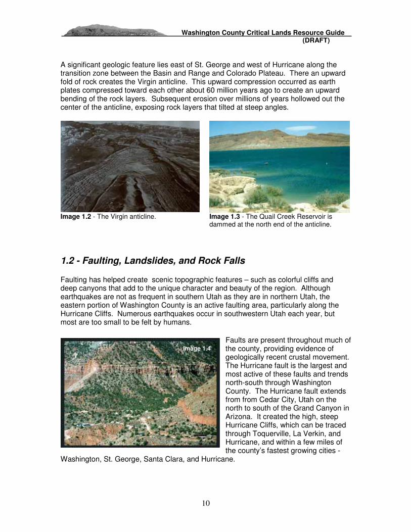
A significant geologic feature lies east of St. George and west of Hurricane along the transition zone between the Basin and Range and Colorado Plateau. There an upward fold of rock creates the Virgin anticline. This upward compression occurred as earth plates compressed toward each other about 60 million years ago to create an upward bending of the rock layers. Subsequent erosion over millions of years hollowed out the center of the anticline, exposing rock layers that tilted at steep angles.
Image 1.2 - The Virgin anticline. Image 1.3 - The Quail Creek Reservoir is
dammed at the north end of the anticline.
1.2 - Faulting, Landslides, and Rock Falls
Faulting has helped create scenic topographic features – such as colorful cliffs and deep canyons that add to the unique character and beauty of the region. Although earthquakes are not as frequent in southern Utah as they are in northern Utah, the eastern portion of Washington County is an active faulting area, particularly along the Hurricane Cliffs. Numerous earthquakes occur in southwestern Utah each year, but most are too small to be felt by humans.
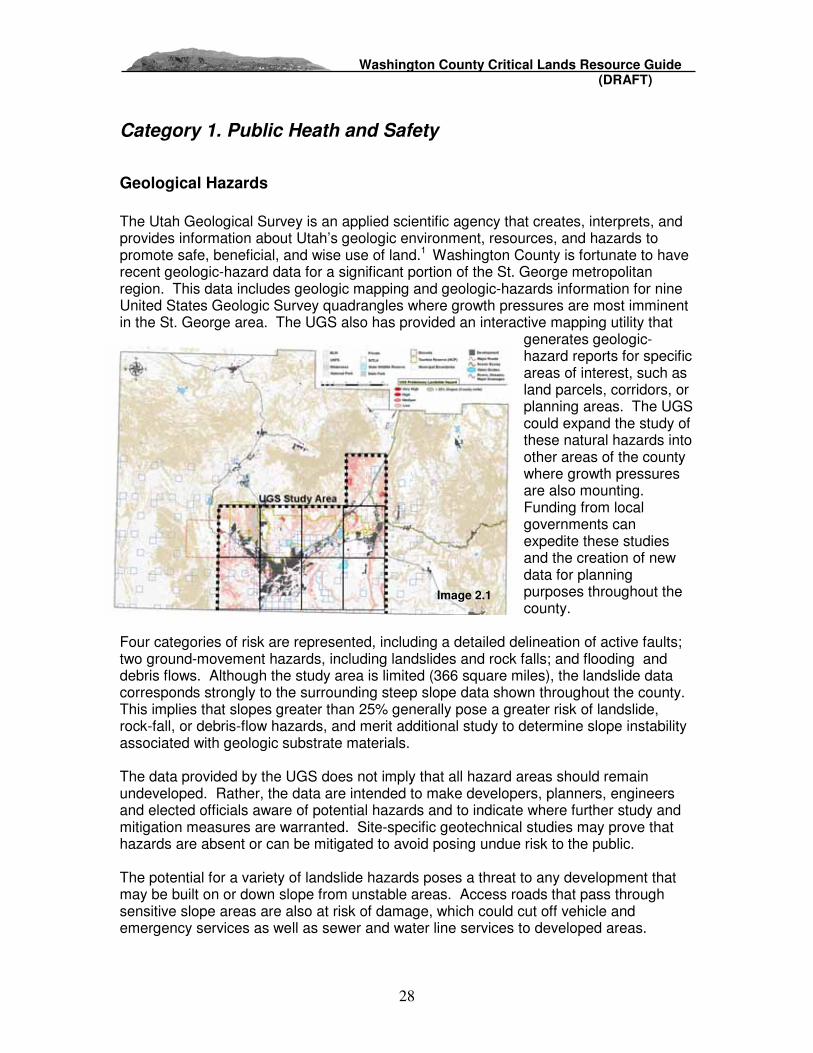
Faults are present throughout much of the county, providing evidence of geologically recent crustal movement. The Hurricane fault is the largest and most active of these faults and trends north-south through Washington County. The Hurricane fault extends from from Cedar City, Utah on the north to south of the Grand Canyon in Arizona. It created the high, steep Hurricane Cliffs, which can be traced through Toquerville, La Verkin, and Hurricane, and within a few miles of the county’s fastest growing cities -
Washington, St. George, Santa Clara, and Hurricane.
Image 1.4

Washington County Critical Lands Resource Guide (DRAFT)
11
The Utah Geologic Survey (UGS) reported that two of the three Hurricane fault segments in Utah have experienced “geologically recent large earthquakes and accompanying surface faulting.” UGS geologists consider the Hurricane fault “to be active and capable of generating earthquakes in excess of magnitude 7.0. Earthquake hazard is measured by 1) the size (magnitude) of the event and the distance from the earthquake epicenter, 2) the local geology ( rock and soil characteristics) and ground-water conditions, and 3) secondary hazards produced chiefly by ground shaking such as rock falls, landslides, liquefaction, subsidence, and floods. Earthquake risk depends on the number, location, design, and construction of manmade structures in the area affected by the earthquake.2
In 1992, the Hurricane fault produced a magnitued 5.8 earthquake that originated about 10 miles southeast of St. George. The quake was felt over an area of 55,212 square miles, with the majority of damage occurring from a triggered landslide near Springdale that blocked State Route 9; ruptured utility lines; and destroyed two water tanks, several storage buildings, and three homes. The landslide occurred over a 10 hour period following the tremors, and has not moved since. Shaking also caused rock falls along the Hurricane Cliffs and changes to the water flow at the Pah Tempe Resort hot springs.3 Prior to 1992, the last moderate sized earthquake in Washington County was in 1902. That earthquake had an estimated magnitude of 6.0. Many smaller earthquakes have been recorded in southwestern Utah by the University of Utah Seismograph Stations, showing the propensity for seismic activity in Washington County.
The University of Utah Seismograph Stations encourage communities to prepare for future earthquakes and related hazards where a moderate or large earthquake is likely to occur. “Residents should be aware of hazards related to earthquakes including ground rupture, ground shaking, rock falls and landslides, liquefaction, and dam failure and flooding,.” 3 Although surface traces of fault lines are mostly mapped along the Hurricane cliffs, the whole region is going to be subject to ground shaking, not just the communities along the fault’s surface trace.
The Five County Association of Governments prepared a regional Natural Hazard Mitigation Plan in 2003. Hazard addressed include wildfire, landslides, flooding, earthquakes, volcanoes, drought, problem soils, severe weather, insect infestations and radon gas. A 72-page section lists community-by-community mitigation strategies, objectives, and actions. This document can be accessed at: http://homelandsecurity.utah.gov/nathaz/plans.htm

Washington County Critical Lands Resource Guide (DRAFT)
12
1.3 - Water Courses
The Virgin River Almost all of Washington County lies within the Virgin River Watershed. The watershed drainage extends to Alton, Glendale and Orderville at the headwaters of the East Fork of the Virgin River. The North Fork of the Virgin River drains much of Zion National Park. Ash Creek and LaVerkin Creek are tributaries to the Virgin River on the north side of the watershed. The Santa Clara River is a large subbasin that drains the western side of the county including
Moody Wash and Magotsu Creek. The Santa Clara River flows through the cities of Santa Clara and St. George and discharges to the Virgin River near the Dixie Center. An often overlooked tributary to the river is Fort Pearce Wash. It has a drainage basin area that exceeds the Virgin River basin and collects drainage from Colorado City and a portion of the Arizona Strip. The Pah Tempe or LaVerkin Hot Springs discharge 11 cubic feet per second of high temperature and very high salinity water from the bed of the Virgin River and areas adjacent to the river.
The Santa Clara River originates in the Pine Valley Mountains and drains into the Virgin River south of St. George. The river was named by the early travelers of the Old Spanish Trail that followed the river. For a short time it was known as the Tonaquint River, named for the small tribe of Tonaquint Indians living further downriver, near the mouth. Some of the primary and secondary irrigation ditches that divert and still carry water today were created over 1,000 years ago by Pueblo Indians.6
Watershed Drainages: Connecting to these two perennial (year round) water courses are many branching drainages that carry snow melt or storm water from mountains, hills, and valleys. Intermittent (seasonal) streams such as the Beaver Dam Wash are defined by areas where surface water is present much of the time, but then ceases to flow when seepage or evapotranspiration exceed the available water supply. Other drainage washes are ephemeral, meaning that water flow occurs after a major rain storm for a few days or weeks after which the wash returns to a dry creek bed condition. Limited annual precipitation in Washington County comes infrequently as concentrated rain storms that can deliver a significant amount of rain in a short time - called monsoons. Given the sparse vegetation through much of Washington County, sudden rain storms dump water directly onto sun-baked soils, and dry wash gullies quickly fill with water.7 This natural phenomenon poses a risk of flash flooding throughout much of the undeveloped areas in the county, particularly where plant community cover is sparse.
Image 1.5
Image 1.6

Washington County Critical Lands Resource Guide (DRAFT)
13
Drainages and gullies should be avoided during rainstorms by hikers and motorists, particularly in high walled canyons. Homes, businesses, or buildings should not be built in the path of drainage gullies to avoid damage from flash flooding or debris flow deposits. River History Between 1854 and 1910, numerous dams and hundreds of miles of canals were built on the Virgin and Santa Clara rivers and their tributaries. This resulted in dramatic changes as a result of irrigation and livestock grazing. During summer months, the demand for water often exceeded the available supply. It was common for entire sections of the river to be diverted into irrigation canals. About 99 percent of all major water rights to the Virgin River system were already allocated by 1910 and probably being fully used. In addition, livestock grazing depleted riparian vegetation along the drainage, increasing erosion and siltation, which led to a decrease of available fish covers. 8 Since 1910, several small reservoirs have been constructed on Virgin River tributaries, primarily to collect water for irrigation use. These reservoirs reduce water flows, affect natural flow patterns, and affect water quality.8 This alteration of hydrologic flows and riparian vegetation has severely impacted water flows, water quality and vegetation which define the habitat for many birds, mammals and fish species. Fish water habitats have also been altered through the introduction of exotic fish species, such as the Red Shiner. As a result of these river alterations, two species of fish (Woundfin and Chub) and one bird species (the Southwest Willow Flycatcher) are listed as endangered by the U.S. Fish and Wildlife Service.
1.4 Flooding
Residents of Washington have experienced periodic incidents of torrential flooding and flash flooding since early settlement days. Two of the most notable events include January 1862, when a raging flood destroyed most of the early settlements of Grafton, Duncans Retreat, Adventure, and Northup along the Virgin River. Grafton’s settlers relocated to one mile upstream onto higher ground where the current townsite now stands.9 This extreme level of destruction was not seen again until January 12, 2005 when Governor Huntsman issued an executive order
declaring Washington County a disaster area. Ravaging floodwaters destroyed over $150 million of homes, roads, bridges and other infrastructure along the Santa Clara River. 10 Other recent flooding events occurred in 1997, and in August 2007.
Image 1.7

Washington County Critical Lands Resource Guide (DRAFT)
14
1.5 - Vegetation - Plant Communities
Several major plant communities in Washington County have adapted to the region’s varied topography, temperatures, and rainfall patterns. These topographical subsections are called ecoregions, which define the boundaries of varied plant communities in the region. A plant community is a grouping of plants that grow together and share similar water, soil, and climate tolerances created by the geology, topography and regional climate of an area. Plants communities often provide symbiotic relationships with other plants, or with animals that require habitat cover and food from plants. For example, some under story plants grow in shade that is provided by taller sun loving plants. A symbiotic plant and animal relationship would be a plant that requires rodents or birds to eat its fruit to disperse seeds for successful reproduction.
The United States Environmental Protection Agency provides classifications of an ecoregion or plant community at different levels of resolution, depending on the scale of study desired. For example, Level I and II ecoregions define general regions of plant communities at a continental or national scale. Level III ecoregions provide a broad delineation of general plant communities at the statewide or multi-county scale, as shown in Figures 1.8 and 1.9 below. Level III ecoregions of Washington County include the Central Basin and Range (13), the Mohave Basin and Range (14), Wasatch Mountains (19), and Colorado Plateaus (20).
Image 1.8, Above: Class III ecoregions of Utah and surrounding states. Image 1.9, Right: Class IV Ecoregions shown within Class III transition lines.
Level IV ecoregions define the diverse and scenic landscape visible throughout the county at a greater resolution, including the topography, plant and animal life, and rainfall patterns. The Virgin and Santa Clara Rivers create a long, linear riparian plant community that is distinct from other ecoregion types. This plant community thrives along a year-round water supply, forming a long and narrow plant community called an ecotone where fish, birds and mammals seek shelter, food and water. The following descriptions11 summarize the ecoregions in Washington County as shown in figures 1.8 and 1.9 above:

Washington County Critical Lands Resource Guide (DRAFT)
15
13. Central Basin and Range
13d Woodland- and Shrub-Covered Low Mountains – are covered by Juniper woodlands at lower elevations, and are mixed with pinyon at higher elevations. The vegetation mix in this ecoregion is distinctly different from surrounding ecoregions, and supports more grazing activity than lower elevation Mojave Basin and Range vegetation. Mountain slopes, hills, and alluvial fans tend to be rocky and rugged, and also contain mountain brush such as bitterbrush and western service berry that provide important browse for mule deer. Croplands and grazing are supported in valleys near water sources.
14. Mojave Basin and Range – is the warmest and driest portion of Washington
County, with little grazing activity due to the sparse vegetation and lack of water sources. Situated in the lower southwestern corner of Washington County, it is the northeastern extent of a much larger Mojave Desert that covers southern Nevada, northwestern Arizona, and a portion of southeastern California. This is the traditional native habitat of the Desert Tortoise, and the well known Joshua tree. Growth of this tree ends where slopes of the Beaver Dam Mountains transition to the summit of Utah Hill (Ref). The Utah Mojave in Washington County includes low Mojave desert floor elevations, the Beaver Dam Wash, and the Beaver Dam Slope.
14a Creosote Bush-Dominated Basins ecoregion contains the lowest elevation in the state of Utah and Washington County at 2,200 feet, and is composed of alluvial fans, valleys, and scattered buttes. Lower elevation creates warmer temperatures and higher evapotranspiration rates. Warmer soils support creosote bush, Joshua tree, blackbrush, big sagebrush, turpentine broom, and associated grasses. 14b Arid Footslopes ecoregion lies between 3,000 and 5,000 feet, and is composed of footslopes, alluvial fans, hills, basalt flows, mesas, and badlands. Sparsely vegetated slopes yield a high sediment erosion loads during summer thunderstorms. Soils sustain big sagebrush, blackrush, Mormon tea, yellowbrush, galleta, Indian ricegrass, cholla, and unfortunately, the noxious cheatgrass.
Image 1.10
Image 1.11

Washington County Critical Lands Resource Guide (DRAFT)
16
14c Mountain Woodland and Shrubland ecoregion is defined as the Beaver Dam Mountains, or Beaver Dam Slope that occurs between 4,000 and 7,800 feet next to the Arid footslopes and the Creosote Bush-Dominated Basins. These mountains are an eroded fault block with mountains and mesa tops that are higher in elevation than the other Mojave ecoregions, with temperatures that are slightly cooler. The landscape is characterized by sparse Juniper-pinyon woodlands and mountain brush with no perennial streams. Although the vegetation is distinctly different, Mojave Desert fauna is found here, including the desert tortoise and the speckled rattle snake.
19. Wasatch Mountains 19e The High Plateaus ecoregion is largely capped by flat-lying igneous rock and is lithologically distinct from the Wasatch Montain Zone. Elevations usually range from about 8,000 to 11,000 feeet, and are accompanied by differences in precipitation and temperature. The subalpine fir, Englemann spruce, Douglas-fir, and aspen communities of plants and animals are widespread, but the ponderosa pine community also occurs at lowest elevations. The vegetation is unlike the juniper-pinyon woodland and mountain
brush found at the Semiarid Foothills. Land uses include seasonal grazing, and recreation. 19f The Semiarid Foothills egoregion lies between an elevation range of 5,000 and 8,000 feet. The vegetation coverage includes widely spaced juniper and pinyon with sagebrush, grama grass, mountain mahogany, and gambel oak. Some wooded vegetation has been cleared and converted to grasses to support grazing.
20. Colorado Plateaus – are characterized by uplifted, eroded, and deeply dissected tableland. Benches, mesas, buttes, salt valleys, cliffs, and canyons are formed in and underlain by thick layers of sedimentary rock. The Plateau region of Utah's Dixie includes the Navajo sandstone, chinlea, and other rock formation knolls, buttes, and mesas located in the south southeastern portion of Washington County including Warner Ridge, Sand Mountain, Mollies Nipple, Vermillion Cliffs and Hurricane Cliffs transitioning into Zion National Park.
Image 1.12
Image 1.13

Washington County Critical Lands Resource Guide (DRAFT)
17
Plants typical of this diverse landscape include pinyon/juniper woodlands, grasslands with Blue Grama Grasses, bunch grasses, and big sagebrush.
20c – The Semiarid Benchlands and Canyonlands ecoregion ranges in elevation from 5,000 to 7,500 feet, and is characterized by broad grass, shrub, and woodland-covered benches and mesas. Low escarpments can be seen that separate remnant mesa tops and narrow canyons from surrounding benches. Bedrock exposures are common along rimes, escarpments, and on steep dip slopes. Soils are composed of fine sand and support warm season grasses, winterfat, Mormon tea, four-wing saltbush, and sagebrush. Pinyon and juniper occur on shallow, stony soils. Fire suppression and erosion has allowed this woodland to expand beyond its original range. 20e The Escarpments ecoregion is characterized by cliff bench complexes that can create local relief as great as 3,000 feet, often forming a dramatic transition from the benchlands and canyonlands ecoregion to the forested mountain rim. Escarpments provide a rugged, remote, and varied landscape with abundant habitat for wildlife. At higher elevations, natural vegetation includes Douglas-fir forests on steep, north-facing slopes, semidesert grassland or shrubland on lower, drier sites, and Pinyon-juniper woodlands on escarpments and benches that are covered by shallow soils. 20h The Sand Deserts ecoregion is flat and arid, with soils that are sandy, and contain a low water holding capacity. Soils formed from sandy eolian deposits, shifting dunes, and exposed sandstone bedrock. With only 5 to 8 inches of annual precipitation, grazing capacity is severely limited, with drought-vegetation growing sparsely on stable sand blankets, including Indian ricegrass, sand dropseed, yucca, and blackbrush. and stock carrying capacity is limited.
The Virgin River Basin is defined as the Santa Clara and Virgin River riparian corridors within the greater St. George drainage basin. This plant community is referred to as an ecotone, or a transitional plant community that creates an abrupt edge or change in an ecoregion. Riparian plants rely on the continual flow of surface water or ground water, and include creosote bush, big saltbush, common reed, false seep willow, sandbar willow, cottonwood, and, sadly, the noxious Tamerisk (salt cedar) and Russian olive that escaped cultivation over the past
century. Many animals rely on the cover or shade provided by these plants, including the Southwest Willow Flycatcher, the Yellow Billed Cuckoo, the Woundfin, and Humpback Chub, as well as larger ungulates that access water ways for drinking water and foraging.
Image 1.14

Washington County Critical Lands Resource Guide (DRAFT)
18
Plant Communities and Wildfire Risk
Wildfires occur as part of the natural lifecycle of a plant community, particularly where wooded vegetation is present in arid or semiarid climates. Fire hazard potential throughout the county is largely based on the types of forest fuels present in various ecoregions, or plant communities. Contiguous coverage of woody tree and shrub forests present a greater potential fire hazard due to the increased fuel load, and potential for fire to burn hotter and longer. A new wildfire risk threatens to disrupt the natural cycle of plant communities
through out the west, and in Washington County. Non native species are overtaking native vegetation, causing a dramatic increase in the frequency of fires. Increased wildfire occurrences are threatening to the public as development spreads further out into wooded vegetation areas, and to animals that rely on vegetation for food and cover. The threat of increased erosion and water quality degradation is also a serious problem following wildfires. These combined factors require additional resources to provide fire protection and mitigation to protect lives and property.
Annual Grasses Posing Increased Wild Fire Risks
Cheatgrass is an aggressive annual grass that has infiltrated much of the natural landscape of the western United States, and continues to spread rapidly in Utah and nearby states, including Nevada, Idaho, and Oregon. The grass is native to central Asia, and was introduced in America through contaminated seed in the 1890s. Cheatgrass grows between 2 inches and 24 inches tall, and becomes dormant by mid June. Dormancy simply means that the grass is in remission, and will return in full force once the spring rains return. Cheatgrass, and other noxious annual grasses are competing and overtaking native
perennial grasses and plants. Although they look like a fresh blanket of green in the spring months, exotic annual grasses quickly becomes dry and brittle in the summer – just as summer temperatures reach their peak and induce fire season. Replacement of longer season native grasses with short season grasses creates ground-level tinder that threatens native plant communities, wildlife, and human development with a heightened
Image 1.15
Image 1.16

Washington County Critical Lands Resource Guide (DRAFT)
19
risk of wildfire. Without cheatgrass and other annuals, wild fire occurrences have typically been every 30 to 70 years in Utah, giving native plant communities a chance to reestablish. However, where annual grasses have their way in native plant communities, the wildfire cycle is now every three to five years.12 Dead annual grass fires burn rapidly, consuming thousands of acres in an hour’s time.13 Where plant communities contain frequent woody shrubs and trees such as Utah Juniper, pinyon pine or sagebrush, a cheat grass fire ignites fuel that will burn hotter and longer, threatening homes that are built amidst native plant communities. Although annual grasses die when spring rains subside into early summer heat, new seeds are released and spread by wind and water erosion for renewed growth the following spring. With the threat of increased wildfire frequency, native plants, including shrubs, trees, and perennial grasses, must compete with annual grasses, and are not likely to reach maturity in time for the next fire. The aggressive annual grasses are also highly opportunistic, thriving in disturbed areas from development and ATV use –or recently burnt areas where annual grass growth appears in abundance the following spring. Problems following wildfire include more ground surface exposure to rain and wind erosion, soil erosion that flows into streams, and increased risk of mudslides on slopes, including developed areas where homes may become more vulnerable to slope failure. After being largely ignored for decades, the now ubiquitous weed is emerging as an ecological threat during summer months to public and private lands in Washington County. The ominous presence of annual grasses threaten the health and safety of humans, as well as the survival of native animals and plant life. In addition to the threat of fire, dormant cheatgrass provides less cover for wildlife such as grouse and pheasant, and less food later in the season for larger ungulate species such as deer and big horn sheep.13 Annual grass control measures include tilling or chemically treating an area, and then replanting with native species that are better for wildlife cover and less of a fire hazard. The former BLM director Kathleen Clark invited "everyone to partner with us in combating noxious and invasive weeds that threaten the economic productivity of millions of acres of public land across the West."14 The Washington County Water Conservancy District has sponsored a number of studies dealing with vegetation management in Washington County. The Virgin River Management Plan and other documents can be accessed at: http://wcwcd.state.ut.us/Plans,%20Studies%20&%20Reports.htm

Washington County Critical Lands Resource Guide (DRAFT)
20
Riparian Water Loss from Invasive Species
Tamarisk (Saltcedar) Native to southern Eurasia, Tamarisk is a streamside plant that was first brought into the U.S. in the early 19th century for ornamental, bank stabilization, and wind break uses. It escaped cultivation in the late 1870’s, and had infested stream banks in the American Southwest by the 1920’s and 1930’s. Tamarisk is a large shrub or small tree with reddish brown bark color that grows below elevations of 7,500 feet, and
can grow in size from 5 feet to 25 feet at maturity. It is characterized by feathery, needle like leaves on multiple stems and long spindly branches with flowers that range in color from reddish pink to white. Flowers from a large tree can produce up to 600,000 windblown seeds each year.
Tamarisk’s aggressive growth can be attributed in part to its ability to spread by seed, root, trunk and branch sprouts, and its ability to survive prolonged flooding and droughts. A Tamarisk tree can survive more than a century, and grows a deep tap root that siphons ground water from depths of up to 100 feet. Although the long spindly branches and thin leaves would appear to be well adapted to arid climates and require less water, a single tamarisk plant siphons and transpires to over 300 gallons of water per day (or the weight of its foliage every hour at 80o F) through its stems and leaves. The Colorado Department of Natural Resources
estimated that tamarisk has consumed 55,000 acres in the state, and draws 170,000 acre feet of water beyond what the native plants would use. This equates to 3 to four acre feet of water loss per acre of dominant tamarisk vegetation stand.15 The loss of water also translates into economic losses, such as an estimated annual hydropower generation loss of $16 to $44 million dollars in the United States due to the salt cedar invasion.16 Tamarisk also thrives in saline and nutrient poor soils, and contributes to increase soil and water salinity as it exudes salt concentrations onto its leaves, and the leaves later fall to the ground. This further degrades growing conditions for native plants, and increases the rate of soil degradation through out the western United States. The plant also can also tolerate extended flooding, where most other plants die if root crowns are inundated with water more than 500 days.17
Image 1.17
Image 1.18

Washington County Critical Lands Resource Guide (DRAFT)
21
Despite excessive water consumption, the branches, foliage and seeds of Tamarisk become highly flamable, and increase the risk for wildfire along riparian corridors, as well as higher drier sites where the plant can establish with a deep root system that reaches ground water. Its capacity to thrive in post-fire conditions also contributes to its ability to replace native plants with a monoculture of noxious vegetation. A thick stand of Tamarisk not only impedes recreation access and enjoyment of water edges, but also restricts high water flows and increases river channel speeds which result in bed scouring and sedimentation. Tamarisk also provides poor wildlife habitat compared to other riparian trees and shrubs although some migratory birds nest in thick stands (including the endangered Southwest Willow Flycatcher which has adapted to this invasive habitat cover). Tamarisk dominates and takes up space that would otherwise grow cottonwood, willow, misquite, and other native riparian plants. A brief summary of Tamarisk threats to a region include:
1. Excessive water consumption 2. Crowding out native vegetation 3. Degraded wildlife habitat 4. Increased soil salinity 5. Increased wildfire frequency 6. Degraded recreational use for humans
Tamarisk Control Tamarisk plants can be removed by digging, pulling and cutting, and by use of herbicide application to foliage or stem stubs. The most common method of control of growth is to cut stems near ground level, and then apply herbicide to the freshly cut stem surface to prevent new sprouts from emerging. To prevent stream destabilization, removal of large stands of tamarisk should be phased over several years to allow the introduction of new native species. The United States Department of Agriculture and the U.S. Fish and Wildlife service have been testing leaf eating beetles from China and Kazakhstan that target the tamarisk foliage. Testing has taken place in field cages since 1999, with the hope of providing a natural enemy to the otherwise unimpeded plant that has little natural opposition. The goal is to gradually allow willow plants to replace tamarisk without threatening Southwest Willow Flycatcher nesting areas. 18 The testing sites are also being monitored to assure that the beetle taste preferences do not adapt to also feed on native plants, or turn to feed on a new plant species if tamarisk is eradicated. 19

Washington County Critical Lands Resource Guide (DRAFT)
22
Russian Olive Russian Olive is a spiny deciduous tree that can grows up to 25 feet tall. It has dull green to grey leaves, rigid and wrinkled bark, yellow flowers in summer, red berry like fruit, and thorny branches. Like Tamarisk, it has a deep tap root that helps it survive during drought seasons by drawing from ground water reserves. Similar to Tamarisk, Russian Olive is overtaking riparian areas throughout the United States, and Washington County’s waterways have not been spared. Native to Southern Europe and Asia, Russian
Olive was introduced in the U.S. during colonial times, and promoted for plantings in the west starting in the early 1900’s. It was used extensively for windbreaks, shelterbelts and wildlife habitat because of its high drought tolerance and adaptability to grow in saline environments. Russian olive was reported as escaping from cultivation in the 1940’s to 1960’s, and it has moved aggressively along water ways, irrigation ditches, and fence lines ever since. Russian olive presents many of the same problems as Tamarisk to humans and wildlife. Its aggressive growth out competes native willow, cottonwood, and other riparian plants, replacing native vegetation with an inferior habitat for birds and fish. In addition to consuming high quantities of water compared to native plants, Russian olive creates a monoculture that chokes out native plants, and excessively thickens stream banks. This wall of vegetation restricts high water flows and intensifies flood scouring to the stream bed and intensifies stream flows channeling. In contrast, native vegetation allows a more natural flood event that re-deposits stream bank erosion, and helps plants to reproduce by spreading seeds and providing new fertile soil deposits. 20
Image 1.19

Washington County Critical Lands Resource Guide (DRAFT)
23
1.6 – Public Lands
Dixie National Forest The Dixie Nation Forest is loved for its spectacular scenery, from high mountain meadows and lakes to multicolored cliffs and steep-walled gorges. Vegetation on the Dixie changes from sparse, desert plants at the lower elevations to stands of low-growing pinion Pine and juniper dominating the mid-elevations. At higher elevations, aspen and conifers such as pine, spruce and fir predominate. A diversity of recreation demands are met by three designated wilderness areas, and camping facilities available across the Forest.
Starting in 1876, Congress began to assess the state of forests in the United States, and by 1881 had formed the Division of Forestry. The Forest Reserve Act of 1891 authorized the potential withdrawal of “forest reserves” from public domain land to manage and protect public interests. The need to prevent deforestation and protect water quality near community settlements became apparent after decades of unmanaged grazing, timber harvesting and mining. In 1901, the Bureau of Forestry was created to manage national forest reserves, later known as the USDA Forest Service, which also managed a growing national interest in outdoor recreation. The mission of balancing a diversity of private and public forest interests while protecting the health of the forest remains the primary goal of the Forest Service today. The National Forest Management Act of 1976 mandates the protection and balance of ecosystems for a healthy forest system, such that “where appropriate and to the extent practicable, the Act will preserve and enhance the diversity of plant and animal communities.” Additionally, sec. 219.12(g) requires the maintenance of viable populations of native vertebrates in national forests.
The Bureau of Land Management - BLM In 1946, the federal Grazing Service was merged with the General Land Office to form the Bureau of Land Management within the Department of the Interior. When the BLM was initially created, there were over 2,000 unrelated and often conflicting laws for managing the public lands. The BLM had no unified legislative mandate until Congress enacted the Federal Land Policy and Management Act of 1976 (FLPMA). In FLPMA, Congress recognized the value of the remaining public lands by declaring
Image 1.20
Image 1.21

Washington County Critical Lands Resource Guide (DRAFT)
24
that these lands would remain in public ownership. Congress also gave us the term "multiple use" management, defined as "management of the public lands and their various resource values so that they are utilized in the combination that will best meet the present and future needs of the American people." 21 The Federal Land Policy and Mangement Act of 1976 requires that “. . . the public lands be managed in a manner that will protect the quality of scientific, scenic, historical, ecological, environmental, air and atmosphereic, water resource, and archeological value; that . . . will preserve and protect certain public land in their natural condition; (and) that will provide food and habitat for fish and wildlife . . .” Furthermore, it is the policy of the Bureau of Land Management “to manage habitat with emphasis on ecocsystems to ensure self-sustaining populations and a natural abundance and diversity of wildlife, fish, and plant resources on public lands.” 22 Although the policy of federal lands disposal was superseded by a policy of retention and management in 1976 (FLPMA), interest in land trading, and interest in policies favoring additional land disposal will continue to enter into local, state, and national policy discussions. Anticipating future land trades, the BLM has developed a preliminary map that identifies lands that could be considered for disposal. The BLM also completed a Resource Management Plan for the Dixie Resource Area in 1998. The complete document can be accessed at: http://www.blm.gov/ut/st/en/prog/planning/existing_plans.html BLM - ACEC’s The BLM has created special management areas called “Areas of Critical Environmental Concern” or an ACEC. This BLM designation requires special focus and management to protect unique landscape features, including scenic, wildlife, prehistoric or historic cultural, or to protect human life and safety from natural hazards, and other resources. BLM – Wilderness Study Areas Study to designate BLM areas containing wilderness like qualities. Although these areas have not been designated by congress as protected wilderness, they are managed with additional protection compared to other BLM areas.
Wilderness Study Areas (WSA)
Areas of Critical Environmental Concern (ACEC) ACEC and WSA
Image 1.22

Washington County Critical Lands Resource Guide (DRAFT)
25
National Park Service (Zion National Park) Woodrow Wilson signed the Organic Act in 1916 to create a National Park Service in response to growing public interest to conserve America’s scenery, natural historic objects and wildlife for future enjoyment and recreation. The National Park Service was created to promote and regulate national parks, monuments, and other unique areas.
The Zion Canyon area was not well known until the Federal Land Survey was completed in 1908. Nearly a decade before the Organic Act, President William Howard Taft was made aware of the survey findings, and declared over 15,000 acres of the main canyon area as a national monument. The monument was called by the name of “Mukuntuweap” in 1909 - named after the Southern Paiute. Only 1,000 visitors managed to visit the monument over the next ten years due to the lack of developed roads. Even with very few visits, word of the beautiful monument spread, and influenced its expansion to more than 76,000 acres, as well as an upgrade to National Park Status in 1919.
Plans were made with local communities in 1921 to pave roads in Washington County, which led to a significant increase of visits to the park. Later, the 5,613 Mt. Carmel Tunnel was built to increase tourism travel on a new road loop that connected Zion Park to the North Rim of the Grand Canyon, Bryce Canyon Nation Park, and Cedar Breaks National Monument. The Union Pacific Railroad created a subsidiary business called the Utah Parks Company, and invested over $1.7 million into infrastructure and improvements around Zion Park. Improvements included a new rail track to Cedar City and railway station, advertising in magazines, and the addition of a bus-touring service from Cedar City to Zion National Park with other stops along the Grand Circle. Also, construction of the Zion National Park Lodge and 46 rental cabins further increased the Park’s popularity, which today draws over 1 million annual visits.23
SITLA The Utah School and Institutional Trust Lands Administration (SITLA) is an independent state agency that is responsible for managing approximately 3.5 million acres of land granted to Utah by Congress at statehood to provide financial support to Utah’s public schools and other state institutions, including the Utah School for the Blind, the University of Utah, and Utah State University. The Utah Constitution requires that these “trust” lands be managed solely for the support of their intended beneficiaries – principally the state’s public schools. Revenue from the use and development of school trust lands is deposited in the State’s Permanent School Fund, a perpetual endowment fund that distributes income annually to each K-12 public and charter school in Utah. The original congressional grants of trust lands to Utah were for over 7,000,000 acres. Approximately half of these lands have been sold or transferred since statehood; former trust lands make up some one third of the private land in Utah. In Washington County, SITLA manages approximately 85,000 acres of trust lands. These lands include scattered one square mile (640 acre) parcels distributed in a checkerboard pattern among BLM lands in rural portions of the County as well as several larger blocks of land in and adjacent to urban areas in St. George, Washington and Hurricane. SITLA maintains a Planning and Development group that has attempted

Washington County Critical Lands Resource Guide (DRAFT)
26
to use principles similar to the Vision Dixie principles to plan its lands to provide for high quality development that is beneficial to local communities and economies. SITLA typically partners with the private sector in the ultimate development of state trust lands; current developments in which SITLA has an interest include Coral Canyon, Kayenta, the Ft. Pierce Industrial Park, Sienna Hills, and Ivory Homes/Hidden Valley. A critical issue involving state trust lands in Washington County is how to enable acquisition of state trust lands that have significant environmental values. SITLA manages over 6,000 acres of school trust lands within the Red Cliffs Desert Reserve, as well as thousands of acres of open space and wildlife habitat in more rural areas of the County. The Vision Dixie principles encourage preservation of these critical school trust lands through a program of voluntary exchanges for public land more suitable for development. Such exchanges could both protect sensitive lands and allow suitable development that would benefit local communities and Utah’s public schools.

Washington County Critical Lands Resource Guide (DRAFT)
27
Section 2. Critical Lands Defined
This section provides a categorization of critical lands, as well as a background description of each land type as a reference to the digital maps available on the County’s website at www.utah. The data attributes and sources are listed in the Appendix. The background information provided in this section and the data attributes listed in the appendix are to be used as a companion guide to the automated mapping reports generated on the Critical Lands website. Critical lands can be categorized into three main groups as they relate to public welfare: The first category is a grouping of land features with characteristics or vulnerabilities that pose a risk to thelife, health, and safety of county residents: Category 1. Public Health and Safety
a. Geologic Hazards a. Landslide b. Rockfall c. Flooding record (10,000 years) d. Earthquakes
b. FEMA flooding data c. Erosion prone soils hazard d. Wildfire Risk
The second category includes land areas that enhance the local or regional quality of life, including aesthetic, cultural, and recreational interests: Category 2. Quality of Life (Public Interests) a. Agricultural Land b. Viewsheds, Ridge Lines d. (Riparian) – habitat, fishing, recreation, clean water etc. e. Scenic Byway The third category may indirectly relate to public health and safety, or to Quality of Life interests, and focuses directly on important wildlife habitat areas in Washington County. One goal of this section is to promote understanding of how negative impacts to federally listed species can be diminished, and to assure that federal regulations do not require additional control over local governance of private land. Category 3. Wildlife Habitat
3a. Threatened and Endangered Species Listed species in Washington County include: The Desert Tortoise, Mexican Spotted Owl, Southwestern Willow Flycatcher, Yellow-Billed Cuckoo, Virgin River Chub, Woundfin, Dwarf bear-claw poppy, Shivwits milkvetch, Homgren milkvetch, and Siler pincushion cactus.
3b. Critical Habitat for Large Ungulate Species Mule Deer, Elk, and Bighorn Sheep migrate over large landscape areas that also provide habitat for many additional plant and animal species.
Washington County Critical Lands Resource Guide (DRAFT)
28
Category 1. Public Heath and Safety
Geological Hazards The Utah Geological Survey is an applied scientific agency that creates, interprets, and provides information about Utah’s geologic environment, resources, and hazards to promote safe, beneficial, and wise use of land.1 Washington County is fortunate to have recent geologic-hazard data for a significant portion of the St. George metropolitan region. This data includes geologic mapping and geologic-hazards information for nine United States Geologic Survey quadrangles where growth pressures are most imminent in the St. George area. The UGS also has provided an interactive mapping utility that
generates geologic-hazard reports for specific areas of interest, such as land parcels, corridors, or planning areas. The UGS could expand the study of these natural hazards into other areas of the county where growth pressures are also mounting. Funding from local governments can expedite these studies and the creation of new data for planning purposes throughout the county.
Four categories of risk are represented, including a detailed delineation of active faults; two ground-movement hazards, including landslides and rock falls; and flooding and debris flows. Although the study area is limited (366 square miles), the landslide data corresponds strongly to the surrounding steep slope data shown throughout the county. This implies that slopes greater than 25% generally pose a greater risk of landslide, rock-fall, or debris-flow hazards, and merit additional study to determine slope instability associated with geologic substrate materials. The data provided by the UGS does not imply that all hazard areas should remain undeveloped. Rather, the data are intended to make developers, planners, engineers and elected officials aware of potential hazards and to indicate where further study and mitigation measures are warranted. Site-specific geotechnical studies may prove that hazards are absent or can be mitigated to avoid posing undue risk to the public. The potential for a variety of landslide hazards poses a threat to any development that may be built on or down slope from unstable areas. Access roads that pass through sensitive slope areas are also at risk of damage, which could cut off vehicle and emergency services as well as sewer and water line services to developed areas.
Image 2.1

Washington County Critical Lands Resource Guide (DRAFT)
29
Three major types of slope failures are common in Utah, including debris flow, sliding, and rock fall:
Image 2.2a: Debris flows are often a result of flooding where sediments and larger debris are deposited along streams, drainages or slopes.
Image 2.2b: Landslides are the downward movement of soil or rock substrate material – typically occurring on steeper slopes.
Image 2.2c: Rock fall from cliffs or steep slopes can be suddenly triggered by snow melt, erosion from rainwater, or seismic activity.
Debris flows from slopes or drainages pose a risk to development that that lies down path from unstable surface materials during high precipitation events or periods of extremely rapid snowmelt. Debris-flow hazard can be reduced by managing wild fires, or grazing that may occur up slope from development. Removing vegetation from slopes, whether from over-grazing, wildfire, or development can increase the hazard of debris flow. Even without human disturbances, debris flows can occur when triggered by abnormal
rainfall or snowmelt. The UGS geologic data shows that young debris-flow deposits are common in some areas of Washington County. The presence of these young deposits indicates that additional debris flows should be expected in the future. Mitigation measures to reduce debris-flow hazard may include revegetation, building debris flow dams at drainage outlets, or preserving open space corridors that correspond with known debris-flow paths.
Landslides may be triggered by earthquakes, but other typical causes of landslide include ground-water buildup or ground saturation from excessive spring runoff or irrigation. Existing landslides in Washington County demonstrate the need to carefully consider the geologic substrate of slopes that may be disturbed by development, or saturated by irrigation. A landslide was triggered by the 1992 St. George
earthquake between Springdale and Zion Nation Park. This event also sent rocks falling onto S.R. 9, and created an escarpment as the hillside slid downward throughout the day. The slide moved about 30 feet to the east, cutting off power to north Springdale and the park and destroying three homes, two water tanks, a number of out buildings,
Image 2.3
Image 2.4

Washington County Critical Lands Resource Guide (DRAFT)
30
and utility lines. Additional homes and businesses were evacuated for fear of after shocks causing additional sliding.
This image of the Truman Drive Slide from 2003 required the condemnation of two homes by Santa Clara City, and abandonment of the road. The landslide started creeping in the early 80’s after road excavation and construction, and began moving more rapidly in 2002. Pillars in the image are part of a failed caisson (an underground concrete pier) wall designed to protect the back lot from landslide enlargement. The landslide occurred on blue clay on moderate to steep slopes.
Rock-Fall Hazard – is a risk for areas below steep slopes where the forces of nature loosen exposed bedrock on mesa, plateau, or cliff faces. Forces of wind, rain, erosion, freeze-thaw, and earthquakes loosen rocks and gravity propels them downslope. Similar to landslides, a strong correlation exists between rock-fall hazard areas and slopes greater than 25% (see online mapping utility). Image 2.6 shows a large rock that destroyed half of a home in Rockville in 2002. Home buyers should be aware that most homeowners insurance policies may cover landslides, but do not usually cover rock-fall damage. Collecting insurance coverage payments for this specific natural disaster may require a battle with the contracted insurance company, as was the case in the 2002 Rockville rockfall. Image 2.7 is a rock-fall photographed outside of Las Vegas, Nevada. The rock shattered on ground impact, with large boulders rolling up to 100 feet on relatively flat ground from the steep slope base.
Of the three types of geologic slope hazards described above, landslides in particular can be triggered by slope disturbance from the development of roads, infrastructure, buildings, or irrigation. Some of the most common causes of landslides include:
1. Saturated soils on slopes: from heavy rainfall, rapid snowmelt, consecutive wet seasons, agriculture or landscape irrigation, roof downspouts, poor drainage, septic-tank effluent, canal leakage, or broken water or sewer lines. 2. Slope Disturbance: grading that cuts into the toe of a slope, adding material to the top of a slope, or excavation that cuts into slopes for new roads or structures.
Image 2.5
Image 2.6
Image 2.7

Washington County Critical Lands Resource Guide (DRAFT)
31
3. Earthquakes: shaking of the earth can trigger failure of unstable slope areas, such as the 1992 Springdale landslide. 4. Erosion: landslide activity that results from water scouring soil and substrate material from the base of a slope.
Landslide Prone Areas include:
1. Existing landslides. 2. Steep natural slopes, particularly in weak geologic materials. 3. Steep construction-related cut or fill slopes. 4. Areas in or at the mouths of steep drainages (such as canyons). 5. Slopes below leaking canals or ponds. 6. Developed hillsides where septic-tank soil-absorption systems are used and
landscapes are irrigated. 7. Below cliffs or hills with outcrops of fractured rock.
Earthquakes The UGS study also delineates potentially active faults capable of generating earthquakes within the nine quadrangle study area. Earlier fault data is also available for the entire county, although the locations are not as accurate. In general, faults are less active in the north and western portions of the county, and more active in the south and eastern areas. The Utah Geological Survey (UGS) recently released Special Study 119, Paleoseismic Investigation and Long-Term Slip History of the Hurricane Fault in Southwestern Utah, which provides critical earthquake information such as timing, recurrence, and size of large surface-faulting earthquakes along the Hurricane fault. This report is part of a more extensive cooperative study of the Hurricane fault in both Utah and Arizona by the UGS and the Arizona Geological Survey. The study was funded by the U.S. Geological Survey through the National Earthquake Hazards Reduction Program and by the States of Utah and Arizona. Site-specific study of active faults can suggest an appropriate buffer to separate buildings and infrastructure from potential areas of ground rupture during earthquakes. Additionally, cliff faces along fault lines, and steep slopes above or below faults present rock-fall and landslide hazards during earthquakes. The likely path of landsliding should be considered when siting homes, businesses, and infrastructure facilities. For additional information, UGS provides a “Homebuyer’s Guide to Earthquake Hazard’s in Utah,” available online at http://geology.utah.gov/online/pdf/pi-38.pdf and an “Earthquake Fault Map of a portion of Washington County,” available at http://geology.utah.gov/online/pi/pi-85.pdf.

Washington County Critical Lands Resource Guide (DRAFT)
32
Flooding and Erosion Four sets of map data are provided to show areas that are at risk for torrential flooding, bank erosion, and flash flooding. These include 1. Erosion hazard boundaries along portions of the Santa Clara and Virgin Rivers, 2. Erosion prone soils near the same major water bodies, 3. Draft FEMA flood-plain areas near major rivers, and 4. Washington County water ways and drainages, including perennial rivers and streams, intermittent streams, and ephemeral drainage washes. 1. Erosion Hazard Boundary Much of the damage from the flooding of 2005 occurred within flood plains that were not well documented. Flood plains were previously considered to only be low lying areas along rivers subject to flood inundation. Flooding in 1997 and again in 2005 revealed the potential for rapid erosion of river embankments by high velocity flood waters. Following the floods in 1997, a local government partnership commenced to delineate areas of erosion prone soils near high-risk flood zones – referred to as the erosion hazard zones. Some areas of this study have been completed, revealing homes and infrastructure that were built on susceptible soils. More funding will allow scientific study of waterways, soils, and geologic formations to progress throughout the entire county. The study will continue to provide the boundary that marks erosive soils near flood-prone rivers that could fail when subjected to high velocity flood waters. 2. Erosion Prone Soils To show the soil erosion potential beyond the current FEMA 100-year flood-plain and erosion-hazard zone maps, a unique soil type is included in the digital map that shows county-wide alluvial riverwash deposits that are considered by the Natural Resource Conservation Service (NRCS) to be subject to flooding and not suitable for development. The soil type is called (FA) – Sandy Fluvaquents and Torrifluvents. This soil type indicates flood-plain areas where the river once meandered, and where it could flow again. A new river alignment may occur gradually over decades, or develop suddenly during a catastrophic flood.
Homes and Development FA Soils Current Erosion Hazard Line Study Limit Erosion Hazard Line Further study of the erosion-hazard boundary line is required to explore full flood plain potential along major drainages, including the Virgin and Santa Clara Rivers.

Washington County Critical Lands Resource Guide (DRAFT)
33
Federal Emergency Management Agency Flood-Plain Mapping Local government officials and stakeholders have worked through the Utah State Department of Public Safety - Division of Homeland Security, to update Federal Emergency Management Agency (FEMA) flood-plain maps. Once completed, these maps will provide a reference for real estate agents, homeowners, and lenders to identify homes that may require FEMA flood insurance. This new data is currently in draft form, and is viewable on map serve. Designated FEMA flood-plain areas are not an exhaustive record of all flooding potential throughout the county. FEMA data shows flooding potential near major drainages that constitute higher risk flood and erosion areas. These flooding categories are listed by level of severity, from 100 Year Floodway (flooding and erosion potential), 100 Year Flood Plain, Sheet Flow (1’ to 3’ Deep), and 500-Year Sheet Flow (less than 1’). Flash-Flood areas typically occur in intermittent creek beds or ephemeral washes that drain from higher elevations into perennial streams and rivers. Washes, and rivers are all prone to flash flooding during major rainfall events. Potential flash-flooding areas along intermittent streams and dry bed drainages are shown as dashed blue lines in the online mapping utility. Depending on the slope, vegetation cover, and rainfall intensity, these drainages bear strong potential for spring flooding, flash flooding, and resulting debris flows during heavy rains and spring snow melt. These drainages should be compared to UGS flood-hazard areas determined by the distribution of alluvial (water deposited) sediment. Communities may wish to consider further protection of the public from flooding and erosion hazard by considering these additional risks.
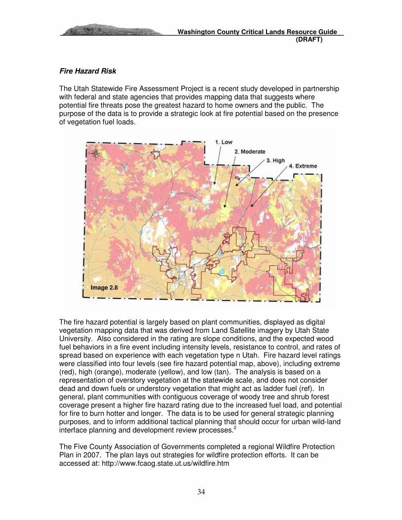
Washington County Critical Lands Resource Guide (DRAFT)
34
Fire Hazard Risk
The Utah Statewide Fire Assessment Project is a recent study developed in partnership with federal and state agencies that provides mapping data that suggests where potential fire threats pose the greatest hazard to home owners and the public. The purpose of the data is to provide a strategic look at fire potential based on the presence of vegetation fuel loads.
The fire hazard potential is largely based on plant communities, displayed as digital vegetation mapping data that was derived from Land Satellite imagery by Utah State University. Also considered in the rating are slope conditions, and the expected wood fuel behaviors in a fire event including intensity levels, resistance to control, and rates of spread based on experience with each vegetation type n Utah. Fire hazard level ratings were classified into four levels (see fire hazard potential map, above), including extreme (red), high (orange), moderate (yellow), and low (tan). The analysis is based on a representation of overstory vegetation at the statewide scale, and does not consider dead and down fuels or understory vegetation that might act as ladder fuel (ref). In general, plant communities with contiguous coverage of woody tree and shrub forest coverage present a higher fire hazard rating due to the increased fuel load, and potential for fire to burn hotter and longer. The data is to be used for general strategic planning purposes, and to inform additional tactical planning that should occur for urban wild-land interface planning and development review processes.2 The Five County Association of Governments completed a regional Wildfire Protection Plan in 2007. The plan lays out strategies for wildfire protection efforts. It can be accessed at: http://www.fcaog.state.ut.us/wildfire.htm
Image 2.8

Washington County Critical Lands Resource Guide (DRAFT)
35
Threatened and Endangered Species Washington County’s extraordinary landscape is home to a number of threatened and endangered wildlife and plant species listed under the Endangered Species Act (ESA) of 1973. The U.S. Fish and Wildlife Service carries out the mandate ESA, which is designed to protect imperiled species from extinction due primarily to growth and resulting habitat loss. The decline of a plant or animal species can signal the diminished health and value of the natural environment in which the species lives, and that supports communities where people live and enjoy clean water, air, or recreational open space. The flora and fauna throughout Washington County contributes to the aesthetic quality of the regional landscape. If sufficiently protected, strategic conservation efforts can support threatened and endangered species recovery programs and prevent additional species from being listed. Local initiatives to preserve critical habitat areas can ensure that direct federal oversight of local development growth management policies is avoided. The following summary describes key ESA policies, and outlines the recovery goals for each species at risk in Washington County. The purpose of this summary is to increase public awareness, and to encourage cooperation between land owners, local governments and federal land agencies as they focus on recovery of listed species in Washington County. Listed species in Washington County include the following (Threatened = T, Endangered = E or Considered Status = C):
Animals Plants - The Desert Tortoise (T) - Mexican Spotted Owl (T) - Southwestern Willow Flycatcher (E) - Yellow-Billed Cukoo (C) - Virgin River Chub (E) - Woundfin (E)
- Dwarf Bear-Claw Poppy (E) - Shivwits Milkvetch (E) - Holmgren Milkvetch (E) - Siler Pincushion Cactus (T)
ESA Critical Habitat and Conservation Provisions: Restoring and endangered or threatened animal or plant to the point where it is again a secure, self-sustaining member of its ecosystem is a primary goal of the Service’s endangered species program. Under the ESA, the Fish and Wildlife Service (FWS) and the National Oceanic and Atmospheric Administration (NOAA) are required to create Recovery Plans for each species outlining goals, tasks required, likely costs, and estimated timeline for recovery for each species.3 Critical habitat areas are not a preserve or refuge, but are rather designated geographic regions that are considered essential for conservation of habitat for a particular plant or animal species. With limited exceptions, the ESA requires that critical habitat be designated for all listed species, encompassing all lands and waters “essential to the conservation of the species” (sec.3[5][A]).“Conservation” is defined as all actions necessary to fully recover and delist species (sec. 3[3]). Federal agencies are prohibited from authorizing, funding, or carrying out actions that are likely to “destroy or adversely

Washington County Critical Lands Resource Guide (DRAFT)
36
modify” critical habitats (sec. 7[a][2]). This prohibition also applies to state or private actions that require federal permits, such as Clean Water Act permits for significant development, mining, logging or cattle operations and the approval of habitat conservation plans by the USFWS and NMFS.4 However, on city, county, state or private land, where no Federal involvement exists, a critical habitat designation has no regulatory impact.5 Under Section 9, it is a criminal offense for any person, including Federal agency personnel, to “take” an endangered fish or wildlife species. The Secretaries of Interior and Commerce have defined “take” to mean harass, harm, pursue, hunt, shoot, wound, kill, trap, capture, or collect, or to attempt to engage in any such conduct. It also makes it unlawful for any person to attempt to commit, solicit another to commit, or cause to be committed, any offense defined in the ESA.6
However, Section 9 does not provide this same level of protection to plants located on private lands. Specifically, the ESA states that it is unlawful to remove and reduce to possession, or maliciously damage or destroy any endangered species of plants from areas under Federal jurisdiction. 7 If there is no federal involvement, and no Habitat Conservation Plan (see below) in place, it is recommended that a private landowner in an area designated as critical habitat contact federal or state officials prior to development. This would allow for the protection of the species as well as the land owner. If a landowner knowing or unknowingly “takes” or kills a species, he/she may be subject to violations and penalties under Section 11. Section 11 describes the violations and penalties that may be enforced under the law. The most punishable offense is enforced on those who knowingly break the law, and may subject to up to $50,000 penalty and or imprisonment for up to one year. Fines are based on the degree and number of violations that one has committed. One may also lose any licensing, permits or other agreements authorized by a federal agency, and lose any hunting or fishing permits issued.
Habitat Conservation Plans In 1982, Congress amended Section 10 of the ESA to authorize “incidental takings” through the development and implementation of Habitat Conservation Plans or HCPs (See the Red Cliff’s Desert Reserve below). An incidental take permit allows a property owner to conduct otherwise lawful activities in the presence of listed species. A non-federal entity must develop an HCP in order to apply for an incidental take permit. The HCP integrates the applicants proposed project or activity with the needs of the species. It describes the anticipated effect of a proposed taking on the affected species, and how that take will be minimized and mitigated.8 In the case of the Red Cliffs Desert Reserve in Washington County, the HCP was developed by local communities, setting aside 62,000 acres of protected habitat designated by the HCP, allowing development on otherwise designated critical habitat outside of the Reserve. One continuing issue of concern is that the HCP committed to acquire all private and state school trust lands within the Reserve, which has not been possible to date due to difficulty in implementing land exchanges and purchases.
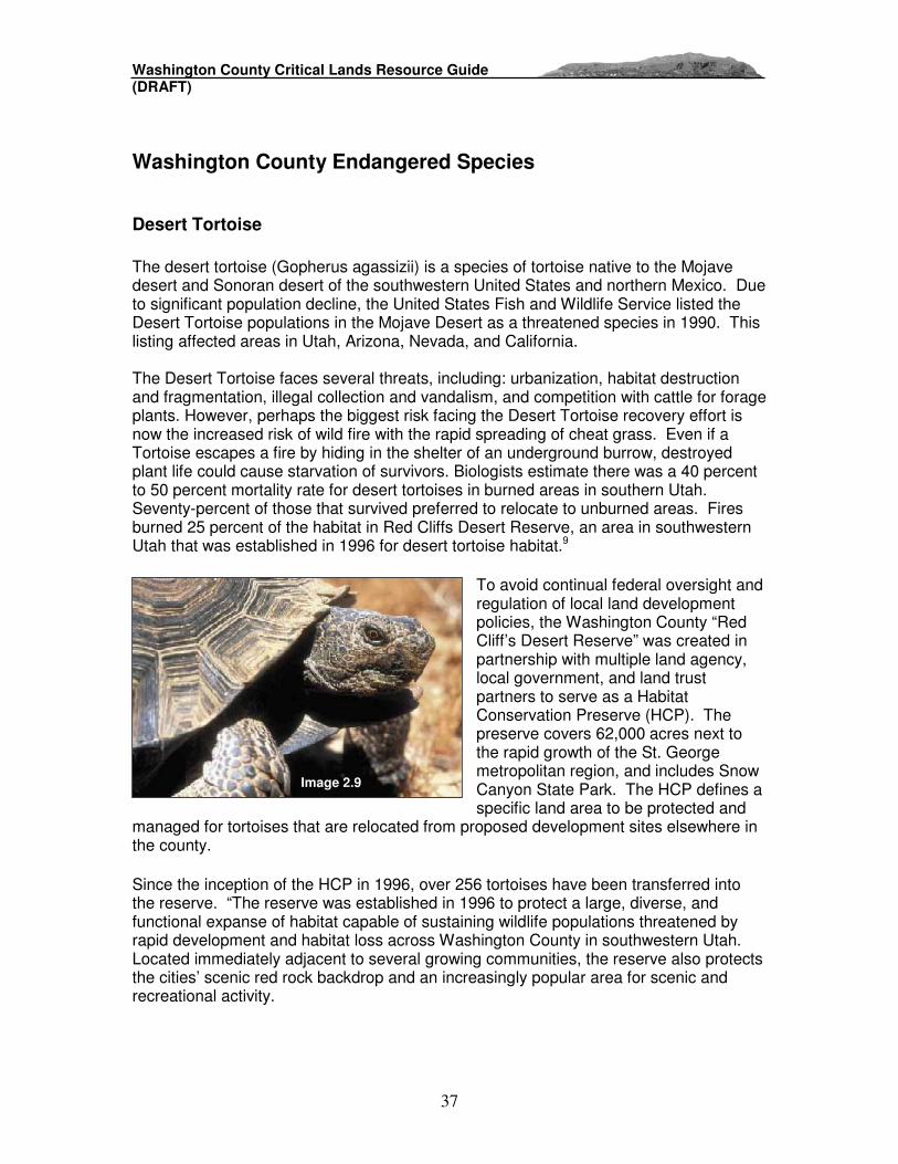
Washington County Critical Lands Resource Guide (DRAFT)
37
Washington County Endangered Species
Desert Tortoise The desert tortoise (Gopherus agassizii) is a species of tortoise native to the Mojave desert and Sonoran desert of the southwestern United States and northern Mexico. Due to significant population decline, the United States Fish and Wildlife Service listed the Desert Tortoise populations in the Mojave Desert as a threatened species in 1990. This listing affected areas in Utah, Arizona, Nevada, and California. The Desert Tortoise faces several threats, including: urbanization, habitat destruction and fragmentation, illegal collection and vandalism, and competition with cattle for forage plants. However, perhaps the biggest risk facing the Desert Tortoise recovery effort is now the increased risk of wild fire with the rapid spreading of cheat grass. Even if a Tortoise escapes a fire by hiding in the shelter of an underground burrow, destroyed plant life could cause starvation of survivors. Biologists estimate there was a 40 percent to 50 percent mortality rate for desert tortoises in burned areas in southern Utah. Seventy-percent of those that survived preferred to relocate to unburned areas. Fires burned 25 percent of the habitat in Red Cliffs Desert Reserve, an area in southwestern Utah that was established in 1996 for desert tortoise habitat.9
To avoid continual federal oversight and regulation of local land development policies, the Washington County “Red Cliff’s Desert Reserve” was created in partnership with multiple land agency, local government, and land trust partners to serve as a Habitat Conservation Preserve (HCP). The preserve covers 62,000 acres next to the rapid growth of the St. George metropolitan region, and includes Snow Canyon State Park. The HCP defines a specific land area to be protected and
managed for tortoises that are relocated from proposed development sites elsewhere in the county.
Since the inception of the HCP in 1996, over 256 tortoises have been transferred into the reserve. “The reserve was established in 1996 to protect a large, diverse, and functional expanse of habitat capable of sustaining wildlife populations threatened by rapid development and habitat loss across Washington County in southwestern Utah. Located immediately adjacent to several growing communities, the reserve also protects the cities’ scenic red rock backdrop and an increasingly popular area for scenic and recreational activity.
Image 2.9

Washington County Critical Lands Resource Guide (DRAFT)
38
Another significant region of Desert Tortoise habitat is located on 48,519 acres of federal BLM lands located in the southwest corner of the county. The area is designated as an “Area of Critical Environmental Concern (ACEC)” a designation that demands special BLM focus and management to protect unique natural values, or to protect human life and safety from natural hazards. This region serves as an additional preserve to help Desert Tortoise flourish and recover to a more stable population.
Mexican Spotted Owl
The Mexican spotted owl is found between central Mexico to the south, and as far north as southern Utah and Colorado in canyon and mountain forest areas. The owl was listed as threatened by the Fish & Wildlife Service on March 16, 1993 (58 FR 14248). The Mexican spotted owl is threatened by the loss of old growth forests (its preferred habitat) throughout its range, starvation and fire. They are also affected by Barred Owl encroachment, great horned owl predation, low reproductive success and low juvenile survival rates.
Following its designation, 4.6 million acres of Federal Lands were identified as critical habitat in Utah, Arizona, Colorado and New Mexico. The image at left shows critical habitat unit CP-11 – which covers the region surrounding Zion National Park in Washington County, and parts of Iron and Kane Counties.
The Mexican Spotted Owl Recovery Plan does not claim that all areas within the habitat unit are critical to the owl, and, private land areas within a general critical habitat region are not included in the designation. Physical and biological features required for the species’ survival require field observation on federal lands, refined mapping, or other consultation.10
The online mapping utility shows the most likely areas within the critical habitat unit that would provide habitat for the Spotted Owl. These areas are based on new predictive habitat data from Utah State University for
Image 2.10
Image 2.11

Washington County Critical Lands Resource Guide (DRAFT)
39
the spotted owl, based on vegetation type, slope aspect, or other features. This interpretation of spotted owl habitat shows the majority of predicted on Federal lands (National Park and BLM), and a much smaller portion extending onto private land holdings. The county could encourage cluster development patterns or transferable development right incentives to preserve important habitat areas within the critical habitat unit to support full species recovery (See Implementation Section 4).
Southwestern Willow Flycatcher The southwestern willow flycatcher (Empidonax traillii extimus) is a small Neotropical migratory bird, with a grayish-green back and wings, whitish throat, a light grey-olive breast, and a pale yellowish belly. The flycatcher’s nesting habitat consists of trees and shrubs along riparian corridors associated with rivers, swamps, wetlands, lakes and reservoirs. These riparian ecosystems provide nesting cover, and access to feed of insects and seeds that are abundant near water. The USFWS proposed to list the
flycatcher as an endangered species in 1993 with 643 miles of riparian habitats proposed for critical habitat designation. The species was designated as endangered on March 29th, 1995 with 599 miles of riparian habitats. The southwestern willow flycatcher’s historic range includes riparian corridors in southern California, southern Nevada, southern Utah, Arizona, New Mexico, western Texas, southwestern Colorado, and northwestern Mexico. Like the majority of southwestern rivers, the quality of riparian vegetation along the Virgin River and its tributaries has suffered greatly over the past century and a half from agriculture, urbanization, dams, and water diversions. Water flows and health of riparian vegetation support many other species of birds, fish and mammals in Washington County. The Virgin River Basin is reported to support 32 species witch are globally rare and of pressing conservation concern (According to the Natural Heritage Programs in Utah, Arizona, and Nevada). The USFWS lists six of these species as endangered; two more are threatened and an additional 24 are being monitored. Many of these species rely on the Virgin River’s riparian habitat which occurs on only 1% of the entire Basin’s land base.11 Federal management of riparian vegetation to support the fly catcher and other sensitive species is limited due to the Core of Engineer’s lack of jurisdictional control above the high water mark elevation. The vegetation line of southwestern rivers is often above the high water line, and often does not meet the definition of jurisdictional wetlands of the United States.
Image 2.12
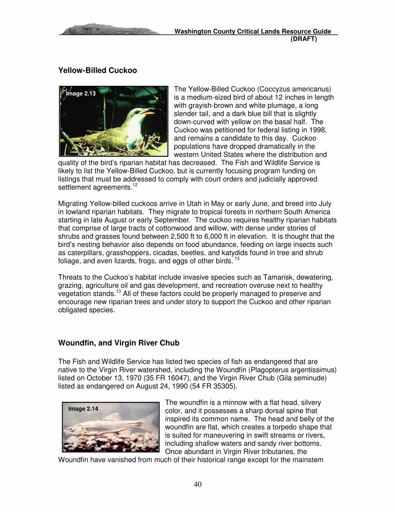
Washington County Critical Lands Resource Guide (DRAFT)
40
Yellow-Billed Cuckoo
The Yellow-Billed Cuckoo (Coccyzus americanus) is a medium-sized bird of about 12 inches in length with grayish-brown and white plumage, a long slender tail, and a dark blue bill that is slightly down-curved with yellow on the basal half. The Cuckoo was petitioned for federal listing in 1998, and remains a candidate to this day. Cuckoo populations have dropped dramatically in the western United States where the distribution and
quality of the bird’s riparian habitat has decreased. The Fish and Wildlife Service is likely to list the Yellow-Billed Cuckoo, but is currently focusing program funding on listings that must be addressed to comply with court orders and judicially approved settlement agreements.12
Migrating Yellow-billed cuckoos arrive in Utah in May or early June, and breed into July in lowland riparian habitats. They migrate to tropical forests in northern South America starting in late August or early September. The cuckoo requires healthy riparian habitats that comprise of large tracts of cottonwood and willow, with dense under stories of shrubs and grasses found between 2,500 ft to 6,000 ft in elevation. It is thought that the bird’s nesting behavior also depends on food abundance, feeding on large insects such as caterpillars, grasshoppers, cicadas, beetles, and katydids found in tree and shrub foliage, and even lizards, frogs, and eggs of other birds. 13 Threats to the Cuckoo’s habitat include invasive species such as Tamarisk, dewatering, grazing, agriculture oil and gas development, and recreation overuse next to healthy vegetation stands.13 All of these factors could be properly managed to preserve and encourage new riparian trees and under story to support the Cuckoo and other riparian obligated species.
Woundfin, and Virgin River Chub The Fish and Wildlife Service has listed two species of fish as endangered that are native to the Virgin River watershed, including the Woundfin (Plagopterus argentissimus) listed on October 13, 1970 (35 FR 16047), and the Virgin River Chub (Gila seminude) listed as endangered on August 24, 1990 (54 FR 35305).
The woundfin is a minnow with a flat head, silvery color, and it possesses a sharp dorsal spine that inspired its common name. The head and belly of the woundfin are flat, which creates a torpedo shape that is suited for maneuvering in swift streams or rivers, including shallow waters and sandy river bottoms. Once abundant in Virgin River tributaries, the
Woundfin have vanished from much of their historical range except for the mainstem
Image 2.13
Image 2.14
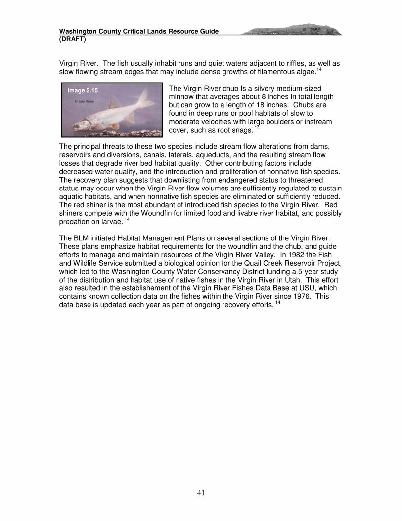
Washington County Critical Lands Resource Guide (DRAFT)
41
Virgin River. The fish usually inhabit runs and quiet waters adjacent to riffles, as well as slow flowing stream edges that may include dense growths of filamentous algae.14
The Virgin River chub Is a silvery medium-sized minnow that averages about 8 inches in total length but can grow to a length of 18 inches. Chubs are found in deep runs or pool habitats of slow to moderate velocities with large boulders or instream cover, such as root snags. 14
The principal threats to these two species include stream flow alterations from dams, reservoirs and diversions, canals, laterals, aqueducts, and the resulting stream flow losses that degrade river bed habitat quality. Other contributing factors include decreased water quality, and the introduction and proliferation of nonnative fish species. The recovery plan suggests that downlisting from endangered status to threatened status may occur when the Virgin River flow volumes are sufficiently regulated to sustain aquatic habitats, and when nonnative fish species are eliminated or sufficiently reduced. The red shiner is the most abundant of introduced fish species to the Virgin River. Red shiners compete with the Woundfin for limited food and livable river habitat, and possibly predation on larvae. 14 The BLM initiated Habitat Management Plans on several sections of the Virgin River. These plans emphasize habitat requirements for the woundfin and the chub, and guide efforts to manage and maintain resources of the Virgin River Valley. In 1982 the Fish and Wildlife Service submitted a biological opinion for the Quail Creek Reservoir Project, which led to the Washington County Water Conservancy District funding a 5-year study of the distribution and habitat use of native fishes in the Virgin River in Utah. This effort also resulted in the establishement of the Virgin River Fishes Data Base at USU, which contains known collection data on the fishes within the Virgin River since 1976. This data base is updated each year as part of ongoing recovery efforts. 14
Image 2.15

Washington County Critical Lands Resource Guide (DRAFT)
42
Shivwits milkvetch (Astragalus ampullarioides),
Holmgren milkvetch (Astragalus holmgreniorum) The Shivwits and Holmgren Milk-vetches are members of the pea family, and are found in portions of Washington County, Utah and Mohave County, Arizona. Both species grow on state and private lands, as well as land managed by the BLM. The Shivwits milk-vetch is found only in southern Washington County, and is also found at Zion National Park and on Tribal lands belonging to the Shivwits band of the Paiutes. The Holmgren milk-vetch is usually found on edges of hill and plateau formations, slightly above or on the edge of drainage areas. These native plants were listed as endangered in October 2001 due to their rarity and declining population trends. Threats to these two species include urban development, off-road vehicle use, grazing, invasive non-native plants, and mineral development.15
The U.S. Fish and Wildlife Service completed a final recovery plan for the Shivwits and Holmgren Milk-vetches in the fall of 2006. The recovery plan is voluntary document rather than binding, and promotes voluntary conservation efforts and cooperation between federal and state agencies, and land owners. The recovery plan identifies specific actions that will help recover the plants so that they may be downlisted to threatened and eventually removed from the list of threatened and endangered species.
Recommended actions include:
• Ensuring the habitat base for each recovery population is large enough to allow for natural population dynamics, population expansion where needed, and the continued presence of pollinators, with sufficient connectivity to allow for gene flow within and among populations;
• Achieving permanent land protection for at least four recovery populations; • Developing site-specific conservation agreements for all recovery populations
and their habitat to protect the milk-vetches within existing State laws; • Prohibiting the use of pesticides or herbicides detrimental to either of the
milkvetches or their pollinators with the vicinity of all recovery populations; and • Collecting and storing seeds for all extant populations16
Image 2.16
Image 2.17

Washington County Critical Lands Resource Guide (DRAFT)
43
Dwarf Bear Claw Poppy (Arctomecon humilis) Dwarf bear claw-poppy, Arctomecon humilis, is a Federally listed endangered plant that is found only in Washington County, Utah. A member of the poppy family, this species is a perennial herb that produces abundant white flowers. The flowers bloom from mid-April through May, and are quite showy next to the red soils in which the plant grows. Dwarf bear claw-poppy is found on gypsiferous clay soils derived from the Moenkopi Formation. It occurs on rolling low hills and ridge tops, often on barren, open sites in warm
desert shrub communities, at elevations ranging from 700 to 1402 meters. The species' habitat is in an area of rapid population growth, and the low barren hills on which the dwarf bear claw poppy grows are impacted by development and off-road vehicle use.17
In addition to serving on the Washington County Desert Tortoise Steering Committee in the early 90’s, The Nature Conservancy (TNC) has also worked to protect the dwarf bear claw poppy – a rare species listed as Endangered by the US Fish and Wildlife Service. This showy, white-petaled wildflower is now known to exist in only 7 small populations in the St. George area – and nowhere else on earth. Several years ago, The Nature Conservancy purchased a 17-acre parcel containing the only dwarf bear claw poppy population that occurs on private land. In 2007 TNC purchased an additional 55.52 acres of dwarf bear claw poppy habitat with plans to purchase another 600 acres over the next few years – all to be established as a nature preserve with public access. On all properties they will continue to study and monitor this rare and beautiful wildflower.
Siler pincushion cactus (Pediocactus sileri) The Siler pincushion cactus is on the Federal list of threatened plants. Its areas of distribution are limited to Kane and Washington Counties in Utah, as well the bordering counties of Coconino and Mohave in Arizona. Although size can vary, this small primarily solitary cactus stands approximately 13.5 cm (5 in) tall and 7.6-10.0 cm (3-4 in) in diameter. Identified by its yellow flowers with purple veins that bloom during March and April, the cactus is found in desert scrub habitat at elevations ranging from 2,800 to 5,400 feet on the white occasionally red gypsiferous clay or sandy soils of the Moenkopi Formation. It may also be found on the nearly identical Kaibab Formation. This species is vulnerable to threats because of its specific habitat requirements. Threats include illegal collection, herbivory by anunknown animal (possibly a species of rodent), uranium mining and exploration, off-road vehicle disturbance, and pesticide application.18
Image 2.18
Image 2.19

Washington County Critical Lands Resource Guide (DRAFT)
44
3a. Critical Habitat for Large Ungulate Species Mule Deer, Elk, and Bighorn Sheep species are well known animals that are popular for hunting, wildlife viewing and photography. Although many other wildlife species could be included in this inventory of wildlife habitat, the presence of larger ungulate (hoofed) animals can serve as an indicator of habitat health for many other species.19
Mule Deer are found in the western half of the United States, and are able to adjust to a range of habitat types – from open deserts to high mountains - with some that even adapt to urban areas. Mule deer eat shrubs, grasses, and other woody materials such as sage brush. Despite the tolerance of many different habitat types and diet choices, local mule deer populations are reduced or eliminated when critical winter habitat is replaced by land development. Deer
depend on southwest facing lower elevation slopes during winter months where snow melts quickly and food sources can be found. Also important to deer are preserved corridors to migrate from winter areas to higher mountain summer foraging areas. Mule deer mate in the late fall, and does give birth to one or two fawns in the late spring or early fall.
Similar to mule deer, the elk (also called wapiti) are drawn to mountain foraging areas in forests and meadows during summer months, and seek lower elevation foothills during the winter. Access to lower elevation grasslands allow the elk to avoid deep snow and survive the winter season. Elk feed mainly on grasses, as well as forbs, woody plants and mushrooms. When the elk mate in the late fall, males compete for harems of females and warn other males to stay away by emitting a loud bugle. Females give birth to one or two calves in the late spring.20
Desert bighorn sheep populations can be found in the Pine Valley mountains and, preferring open rocky areas where they have adapted to maneuvering over steep slopes and rock outcrops for protection from predators. These Utah natives feed opportunistically on a variety of plant material, including cacti, grasses, and other plant materials. These foods provide the bighorn sheep with
internal moisture that reduces the amount of drinking water required for comfort and survival. Females give birth to one lamb in the late spring. Big horn sheep populations are not as likely to be found where growth and development occur. The primary threat to the sheep is the intrusion of annual grasses, such as cheat grass that overtakes other native vegetation, increases wildfire occurrences, and reduces foraging opportunities for larger ungulate species.21
Image 2.20
Image 2.21
Image 2.22

Washington County Critical Lands Resource Guide (DRAFT)
45
Section 3: Vision Dixie – Public Involvement Supporting Critical Lands Preservation
Data gathered during the 2006-2007 Vision Dixie public engagement process suggest general support for critical lands preservation in Washington County. During September and October 2006, Vision Dixie sponsored 13 public workshops in various communities throughout the county. Over 1,200 citizens participated. Participants worked as teams to explore ideas for accommodating projected growth in a sub-region of the county. Each team worked with a base map plotted over aerial imagery that showed land in public and private ownership, developed areas, roads, and water ways. Some sensitive land features were also designated on the map, including FEMA flood plains and steep slopes over 25%.
Vision Dixie Workshop Base Map

Washington County Critical Lands Resource Guide (DRAFT)
46
Each group had an 11 x 17 atlas showing sensitive lands information, including the additional features of geologic hazards, farmland, critical habitat for threatened and endangered plant and animal species, and BLM ACEC and Wilderness Study Areas. Participants were encouraged to refer to the atlas as they made decisions about future growth patterns. Although farmland areas featured in the atlas were not highlighted on the base map, farming areas and access roads were visible in the aerial imagery. Participants from rural areas in particular seemed to recognize farmland in their region. Workshop participants used markers, tape and paper chips to designate on their base maps areas most appropriate for development, their preferred types of land use and transportation, and areas they believed should not be developed. They did not distinguish between critical lands and land they hoped would remain undeveloped for other reasons. The green area on the map below shows where workshop participants preferred that no development occur. Such area might include agricultural land, parks, habitat, scenic corridors, riparian areas or other undeveloped land uses. The red color represents all other types of future developed land. This simplified view of developed vs. non-developed land use reflects the input by participants from all 13 workshops.
Dominant land use types from workshop input. Green, dominant undeveloped land; Red, dominant development. The abrupt edges of green undeveloped areas are due to the map boundaries for each workshop subregion. This map reflects the preference of the majority of table groups that selected a specific area for development or for preservation. For example, if 10 table groups each worked on a base map, and six out of the ten tables colored an area green for preservation, the area would show up on this map as a public preference against development. If equal numbers of maps designated an area for development and no development, the more intense land use prevailed. For example, if five of ten tables designated an area for no

Washington County Critical Lands Resource Guide (DRAFT)
47
development, and the other five selected the same area for single-family homes, the area would be red on the map, reflecting a preference for single-family homes. The workshop results were analyzed and formed the basis for four distinct scenarios of how the county might develop in the future. Each option was evaluated using modeling techniques to determine how each option performed relative to a variety of public interest indicators. In the spring of 2007, the public reconvened to review and react to the growth scenarios and performance measures. Members of the public participated through a telephone poll, online survey, and in public forums where they could respond to questions using live keypad polling technology. Some of the questions to which participants responded dealt with critical lands. For example, when asked about the level of land conservation Washington County should work toward, nearly everyone believed “flood plains and rare habitats” should be preserved. A majority of residents also believed that “scenic backdrops like ridges and steep slopes,” “major recreation areas,” and “open space areas that separate communities from each other” should be preserved. Residents also had an opportunity to prioritize a diverse list of goals for the county. Goals such as “preserve scenic beauty, including ridgelines and steep slopes,” and “preserve wildlife habitat” received significant support, even above goals such as “reduce the need to drive long distances” and “keep housing reasonably priced.” The public input, expressing preferences for various elements of the scenarios, served as the basis for a series of Vision Dixie growth principles—statements providing guidance to local jurisdictions as they make critical decisions about land use and transportation. These principles, in turn, underlie the Vision Scenario, a plausible view of Washington County development in 2040, which contemplates growth occurring in an efficient manner and reflects public preferences for areas to be left undeveloped.

Washington County Critical Lands Resource Guide (DRAFT)
48
Vision Dixie provides a target for future growth in Washington County, and sees that growth being shaped in efficient growth patterns that infringe minimally on surrounding critical and other undeveloped lands. The above map of the Vision Scenario illustrates concentric growth patterns that can accommodate over three times the existing population and workforce without consuming as much land area as current growth trends. The following section, “Implementation Tools and Techniques,” provides an overview of planning and zoning codes that local governments may adopt to preserve critical lands and shape growth to be consistent with the Vision Scenario and growth principles.

Washington County Critical Lands Resource Guide (DRAFT)
49
Section 4: Implementation Tools and Techniques Although rapid growth may appear as a threat to surrounding natural areas, the demand for new homes and businesses can in fact serve as a catalyst for the permanent preservation of critical lands. This section outlines how development rights may be clustered, transferred, or purchased from sensitive areas into areas where growth is less destructive to the environment. Additionally, local governments can work in cooperation with state and federal agencies to identify resources and strategies, and address common threats in the county. Threats include invasive plant species that threaten the natural beauty and function of the region. Recommendations for regular action to protect of critical lands and natural resources include the following:
1. Encourage communities to identify and consider all critical land categories as part of regular development review projects.
a. This can be done simply by exploring the new online mapping utility that is available to the public, including developers, land owners, and city/county staff
b. Adopt development review criteria that requires each critical land issue to be addressed for preliminary plan approval(s)
2. Obtain additional hazard data
a. Expand erosion hazard delineation b. Identify funding sources to expand the Utah Geological Survey’s hazard
data near incorporated cities where growth is likely to occur
3. Work cooperatively with local, state, and federal government agencies to eradicate and prevent the spread of invasive plant species, including:
a. Cheat grass and other annual grasses b. Tamerisk c. Russian Olive
4. Purchase of Development Rights
Funding Sources (Real Estate Transaction Fee) (Quality Growth Commission Fund Descriptions
Federal – NRCS 5. Work cooperatively with SITLA and BLM to implement land exchanges to enable preservation of environmentally sensitive state trust lands.

Washington County Critical Lands Resource Guide (DRAFT)
50
Section 4.1 - Strategic Development Codes to Preserve Corridors and Open Space This toolkit section provides a variety of planning and zoning strategies to help communities plan, design, implement, and fund preservation of sensitive lands. This information is outlined as a resource for each jurisdiction to consider and choose the most appropriate course of action for a specific project or general policy. Communities may wish to develop some of these strategies into their general plans, development ordinances, or resolutions of support. Preservation tools, or development codes covered in this section allow communities and developers to create livable neighborhoods while preserving critical open space areas or corridors for trail easement, recreation, or land conservation. The following tools and techniques are described: -Planned Unit Development Agreements -Cluster Development -Conservation Easements -Private HOA/Public Agreements -Transfer of Development Rights (TDR) -River Setback Requirement Open space requirements or incentives in a community’s development code can be a method of preserving critical lands without spending public dollars for preservation. However, the level of preservation and future maintenance of the open space must be considered as the development code regulations are created. Key considerations when defining preservation as part of new development include 1) Whether the open space should remain in a natural condition, or if it should be converted to recreational use, or remain as agricultural, and 2) The ownership of the property, and the ongoing maintenance responsibility. A local government can require open space as part of a development, but cannot require a developer to create public access to the open space, or prevent subdivision residents access to a sensitive area, or create a public trail corridor as part of the development without offering some additional incentives in the development agreement. This is based on case law that protects a developer from being required to provide new amenities for residents other than those that will live in the proposed development. Some services such as water delivery, sewer, arterial roads, and parks may require impact fees to reimburse the public for provision of these external services to the developer. Preserved open space intended for the benefit of the whole community should not be confused with private open space created exclusively for residents of a development’s home owners association. Rather than requiring private open space in a proposed development (which tends to be recreational), a local government may negotiate with a developer to encourage a sensitive area with limited public access that is deeded to the city or county for public protection. The following zoning techniques provide developers

Washington County Critical Lands Resource Guide (DRAFT)
51
with the option to develop without open space (with fewer dwelling units per acre), or to pursue a greater number of dwelling units per acre in exchange for the provision of public trail or open space amenities.
Planned Unit Development Agreement: A PUD may encourage open space that is owned and maintained by a local government, or by a home owners association (HOA). The HOA may establish covenants to protect sensitive areas, with a plan to provide ongoing maintenance of the property. Public open space intended for community-wide use should be owned and maintained by the local government, whereas club houses and grounds intended for the development only should be owned and maintained by the HOA.
Cluster Development: Similar to a planned unit development, cluster development provides an additional option or incentive to existing zoning, and can be used to create incentives for natural areas, parkways, or other types of open space. Cluster Development allows for significant reduction in lot size to preserve a remaining open space area. Smaller lot sizes with reduced frontage widths tend to reduce the street related infrastructure costs, including roads, sidewalks, sewer, and water lines. Additional incentive can be created by offering more dwelling units through a density bonus (such as 10 percent or more) if the clustering option is pursued. Cluster development is an effective tool for preserving an open space edge of a development as a less restrictive method for preserving floodways, parkways, or the base of slopes where potential rock fall or land slide areas present a hazard.
Development of 49 1- acre lots without public access along the river corridor, and with some homes lying in a flood plain. 1
Cluster development on ½ acre lots with a 25% density bonus creates 61 homes while protecting homes from flooding, and preserving public access along the river. 1
In contrast to a PUD ordinance, cluster development usually places less emphasis on full public ownership, maintenance and access to the open space. A public trail easement can still be provided next to preserved open space that allows “visual access,” as opposed to physical access to the open space. Cluster development ordinances may vary in density, and vary in the percentage of land that is encouraged for preservation. As such, cluster development can apply to both rural or urban settings. A number of

Washington County Critical Lands Resource Guide (DRAFT)
52
cluster development ordinances are active in Utah communities, including Marriot Slaterville, Wellsville, Farmington, Hooper, Weber County, and Cache County. Clustering in Rural Areas Cluster development can be used to preserve sensitive lands or agricultural lands. In rural communities, a lower base density (or by-right density such as 1 unit per acre, or 1 unit per 5 acres) can encourage a large amount of land preservation if significantly smaller lots are encouraged while maintaining a similar base density. The reduced infrastructure quantities and associated costs associated with clustering will benefit not only the developer, but also the local government providing road maintenance and other services.
A 1.25 acre minimum lot size zoning yields 30 lots and 4,118 feet of road length.
Cluster development reduces the average lot size to 0.44 acres, and reduces the total road length to 2,650 feet. Smaller lots reduce the water required for landscaping by one third, allowing water rights to be used for farmland or pasture preservation. Reduced road mileage reduces maintenance costs to the city for the same number of homes. Smaller lots may require septic drainage into surrounding open space area or design of group septic systems.
Securing Open Space Maintenance and Protection How can a community assure that preserved open space areas remain protected into perpetuity? Several methods may be required to prevent the possibility of a future land owner or legislative body from backing out of a contract to protect an area from development. A conservation easement is a legal document that allows a second party to restrict development of property held by a primary party. A conservation easement may also include a third party that holds enforcement rights to the conservation easement. For example, a city might hold a conservation easement to a private land parcel, and a local land trust might hold the enforcement rights to assure that future city officials do not attempt to relinquish their ownership of the conservation easement. In Utah, a

Washington County Critical Lands Resource Guide (DRAFT)
53
conservation easement may only be held or enforced by a private non-profit land trust or any government entity, whether it be federal, state, local, or a special service district. A land trust organization may not be interested in holding and easement on all open space projects preserved through cluster development, or through transfer of development rights (see the following section). Land trusts seek to protect land with significant value for the purpose of their organization, such as wildlife habitat, water quality or agricultural preservation.
Private HOA and Public Development Agreements Development approval of a planned unit development or cluster subdivision may include the formation of a homeowner’s association (HOA) that owns and maintains the open space areas. The HOA is a private body comprised of residents in a specific development that collectively own open space or other amenities in a development. The body is established by the developer who seeks approval from a local government during the development permitting process. An HOA’s responsibilities are established through the development of codes, covenants and restrictions that guide the on-going care of the common amenities. Such codes typically require a monthly fee to maintain common areas, including open space. Unfortunately, it is not uncommon to hear mention of an HOA who’s ability to enforce codes and monthly fees has disintegrated over time, and the amenities have become neglected and unsightly. This could be tragic for a cluster subdivision where preserved open space, pasture or farmland is not properly maintained, and becomes an unsightly patch of weeds.
Public Enforcement Rights Through some trial and error, communities have learned to establish safeguards as part of the HOA approval process. For example, Midway City requires the following language to be included in the Codes, Covenants and Restrictions for Planned Unit Developments in Midway, Utah.
"Midway City shall have the right, but not the duty, to require, and if necessary, perform, at the Association's expense, landscaping, maintenance, and snow removal within the common areas if the Association fails adequately to perform such. In the event Midway City exercises this right, the City shall be entitled to recover any associated costs and attorney fees. This section shall not be amended or deleted without the approval of Midway City."
Another example from South Jordan City further states that the “City has the right, but not the duty to form, under State statutes, a Special Service District (SSD) for the purpose of ongoing maintenance or a Special Improvement District (SID) for the purpose of making needed improvements within the project. The City may take this action when either asked to take over improvements or maintenance tasks by the Home Owners Association, or by an owner. The City Council may also take one or both of these actions when it determines the need based on a historical pattern of a lack of care and maintenance.

Washington County Critical Lands Resource Guide (DRAFT)
54
HOA and Public Preservation Safeguards As an added measure of protection, a conservation easement could be held by a local government on private open space owned and maintained by an HOA. To prevent a future elected community council from relinquishing the easement and encouraging development of the open space, the codes, covenants and restrictions should require that a majority or unanimous vote of residents in the HOA approve of the open space conversion. This dual protection of HOA and elected official vote assures that preserved open space is both desired, and protected in the long term.

Washington County Critical Lands Resource Guide (DRAFT)
55
Transfer of Development Rights (TDR): A transfer of development rights program may be adopted by a community to allow developers the option of purchasing additional development rights from other land owners. Additional development rights would allow a developer to increase the number of dwelling units in a proposed development while preserving sensitive lands elsewhere in the community.
Image a. Vacant land with sensitive land areas shown in the background.
Image b. Typical growth pattern with suburbs in foreground and low density development occurring on sensitive lands.
Image c. TDR application including more compact development in foreground, suburbs and lower density growth in the mid ground, and preserved sensitive lands in the background. 1
A TDR program establishes areas where increased density would be appropriate (receiving zones), and areas desired for preservation (sending zones). Land owners in sending zones may choose to sell their development rights to developers if they agree to a conservation easement that would restrict future development on their property. A TDR tends to equalize land values as opposed to zoning some land as open space or

Washington County Critical Lands Resource Guide (DRAFT)
56
low density agriculture (lower value zoning), and other areas as low, medium or high density single family, multi-family, or commercial zoning (higher value zoning). The transfer (or sale) of development rights helps to preserve strategic sensitive land areas that might otherwise be disrupted through a partial preservation achieved with cluster development. Target preservation goals for TDR might include sensitive mountain bench areas, water shed protection, floodplains, mixed wetland and upland areas, riparian corridors, and agland.
Mapleton City’s TDR program has been successful in preserving much of the privately owned upper bench area next to U.S. Forest Service land. This will help to reduce service costs in the community, preserve critical winter deer habitat, and allow for development of the Bonneville Shoreline Trail.2
River Buffer or Setback (Applied to Commercial, Multi-family, or Mixed Use Development: (See Appendix) A minimum development setback along sensitive rivers, streams or wetlands can help to create an open space buffer, including a trail easement, while protecting water quality, and enhancing wildlife habitat. Increasing the distance between buildings or parking surfaces from a river edge helps to reduce storm water runoff into the river that can carry pollutants from vehicles. Storm water should be diverted away from rivers and detained. Additionally, a native vegetation requirement along river edges can protect water quality and enhance the natural aesthetic and habitat value by creating vegetative cover and by reducing lawn fertilizers that may pollute the water.

Washington County Critical Lands Resource Guide (DRAFT)
57
Overview – Image Sources 1.1 - Mountain sheep petroglyph, Ivins, UT Available www.surweb.org, September, 2007. 1.2 - http://historytogo.utah.gov/utah_chapters/american_indians/ utahspaiuteindiansduringthedepression.html 1.3 - http://www.ghosttowns.com/states/ut/grafton.html Overview - References 1. www.nps.gov/archive/zion/HumanHistory.htm 2. http://www.lofthouse.com/USA/Utah/washington/shivwit.html 4..http://historytogo.utah.gov/people/ethnic_cultures/the_history_of_utahs_american_indians/chapter4.html 5..http://historytogo.utah.gov/utah_chapters/american_indians/utahspaiuteindiansduringthedepression.html 6. http://www.media.utah.edu/UHE/c/COLONIZATION.html 7. Utah GOPB – Demographic and Economic Analysis population projections 8. Derived from the Assessor building record data of Washington County Parcel Data. Methodology was a query of all residential housing units built since the year 2000, excluding parcels over 10 acres. The total acreage of the remaining parcels was added, and divided by the total years from 2000 to 2005. Section 1 - Image Sources 1.1 - http://geology.utah.gov/surveynotes/gladasked/gladtopoform.htm 1.2 – http://www.geo.umn.edu/courses/1001/Summer_Session/VirginRiverAnticline.jpg 1.3 - http://www.gly.uga.edu/railsback/VFT/VFTVirginAnticline.html 1.4 - http://www.seis.utah.edu/edservices/EES/SWUTAHCLOCK.shtml 1.5 - http://ut.water.usgs.gov/Basins/VirginRiverBasin/09413500.html 1.6 - http://ut.water.usgs.gov/Basins/VirginRiverBasin/09409880.html 1.7 - http://www.utahfloodrelief.com/need.html 1.8, 1.9 - http://www.epa.gov/wed/pages/ecoregions/ut_eco.htm 1.10 - http://www.utahlepsociety.org/utahmojave.html 1.11 - http://www.utahlepsociety.org/utahmojave.html 1.12 - http://www.utahforests.org/phex.pl?ph=1281&whence=pv 1.13 - http://www.latimes.com/travel/la-trw-westerncanyons-pg,0,6099700.photogallery?index=21 1.14 - Photograph © 2005 Tom Schweich. Used by permission http://www.schweich.com/imagehtml/IMGP1342sm.html 1.15 - http://www.ksl.com/?nid=148&sid=327325 1.16 - Great Basin wild rye and cheatgrass. Photo by Ralph Maughan http://wolves.wordpress.com/2007/07/16/why-cheatgrass-wins/ 1.17 - http://academic.emporia.edu/aberjame/wetland/wet_veg/veg70.jpg 1.18 - http://www.ucweeds.org/weedlist/tamarix/ 1.19 - Russian olive image – unknown online source 1.20 - http://66.70.224.3/Photos1/690-590-15.jpg 1.21 - http://www.so-utah.com/zion/eaststg/warnervl/ftpierce.jpg Section 1 References 1. - http://geology.utah.gov/surveynotes/gladasked/gladtopoform.htm 2. - http://geology.utah.gov/utahgeo/hazards/eqfault/index.htm 3. - http://www.seis.utah.edu/edservices/EES/SWUTAHCLOCK.shtml 4. - http://www.sltrib.com/news/ci_7782058 - or Ken’s Ref 5. - http://www.media.utah.edu/UHE/h/HURRICANE.html 6. - Odyssey of the Pueblo Indians: An Introduction to Pueblo Indian Petroglyphs. William M. Eaton. Published 2002, Turner Publishing Company 7. - http://en.wikipedia.org/wiki/Beaver_Dam_Wash 8. - USFW, Virgin River Fishes Recovery Plan, Final Revision 2 – pgs 12 - 13

Washington County Critical Lands Resource Guide (DRAFT)
58
http://ecos.fws.gov/speciesProfile/SpeciesReport.do?spcode=E02A 9. - http://www.graftonheritage.org/settlement.htm 10. - http://www.utahfloodrelief.com/need.html 11. - http://www.epa.gov/wed/pages/ecoregions/ut_eco.htm 12. - Baird, Joe and Havnes, Mark. Invasive Plants on Rampage. July 6, 2006. SL Tribune 13. - http://www.rgj.com/news2/stories/news/973656561.php 14. - http://deseretnews.com/dn/view/0,1249,635172346,00.html 15. – http://cospl.blogspot.com/2007/07/tamarisk.html http://www.cde.state.co.us/artemis/nr1_2/NR12T152004INTERNET.pdf 16. - http://seo.state.wy.us/Forum/2007/Noxious%20Weed%20Control%20in%20Wyoming.ppt 17. - http://www.gcrg.org/bqr/6-2/scourge.htm 18. – http://www.ars.usda.gov/is/pr/1999/990708.htm 19. - http://www.sciencemag.org/cgi/content/summary/284/5418/1255 20. - http://seo.state.wy.us/Forum/2007/Noxious%20Weed%20Control%20in%20Wyoming.ppt 21. - http://www.blm.gov/nhp/facts/index.htm#history 22. - BLM manual 6500.06 23. - http://www.travelwest.net/parks/zion/history.html 24. - http://www.utahtrustlands.com/about/ Section 2 - Image Sources 2.1 – Image created using Utah Geologic Survey GIS data 2.2a, 2.2b, 2.2c – http://geology.utah.gov/online_html/pi/pi-58/pi58pg1.htm 2.3 - http://geology.utah.gov/utahgeo/hazards/landslide/index.htm 2.4 - http://seis.natsci.csulb.edu/bperry/Mass%20Wasting/Types_of_Mass_Wasting.htm 2.5 - http://geology.utah.gov/utahgeo/hazards/landslide/slide_show/slidepages/slide05.htm 2.6 - Image provided by Utah Geologic Survey, Cedar City, UT 2.7 - http://seis.natsci.csulb.edu/bperry/Mass%20Wasting/Types_of_Mass_Wasting.htm 2.8 - Mapping data provided by the Utah Statewide Fire Assessment Project 2.9 – http://www.fhwa.dot.gov/environment/wildlifeprotection/index.cfm?fuseaction= home.viewArticle&articleID=32 2.10 - http://geochange.er.usgs.gov/sw/impacts/biology/birds/ 2.11 - http://www.fws.gov/southwest/es/mso/critical_habitat/critical_habitat.htm#maps 2.12 - http://www.backfromthebrink.org/specieslearnabout.cfm?animal_id=5 2.13 - http://www.epa.gov/gmpo/education/photo/birds-animals/img033.jpg 2.14 - http://dwrcdc.nr.utah.gov/rsgis2/search/Display.asp?FlNm=plagarge 2.15 - http://www.fws.gov/southwest/es/arizona/Virgin_Chub.htm 2.16 - http://www.fws.gov/mountain-prairie/PRESSREL/00-11.htm 2.17 - http://www.fws.gov/mountain-prairie/PRESSREL/00-11.htm 2.18 - http://www.nature.org/wherewework/northamerica/states/utah/press/press3037.html 2.19 - http://www.fws.gov/southwest/es/arizona/siler.htm 2.20, 2.21, 2.22 - http://dwrcdc.nr.utah.gov/rsgis2/Search/SearchVerts.asp Section 2 - References 2.1 - Geologic Hazards information summarized in this subsection is from the Utah Geologic Survey. http://geology.utah.gov Cedar City Office Contact: William R. Lund, (435) 865-9041 2.2 - Utah Statewide Fire Assessment Project - http://www.ut.blm.gov/fireplanning/bulletin1.htm 2.3 – www.wikipedia.org 2.4 - http://www.bioone.org/perlserv/?request=get-abstract&doi=10.1641%2F0006- 3568(2005)055%5B0360%3ATEOTES%5D2.0.CO%3B2&ct=1 2.5 - http://www.fws.gov/sacramento/es/crit_hab.htm 2.6 - http://www.fws.gov/endangered/policy/sec_9.htm 2.7 - http://www.info.usda.gov/scripts/lpsiis.dll/H/H_190_610_G_103.htm

Washington County Critical Lands Resource Guide (DRAFT)
59
2.8 - Nelson 1999 2.9 - http://www.reviewjournal.com/lvrj_home/2007/Feb-24-Sat-2007/news/12791003.html 2.10 - http://www.fws.gov/southwest/es/mso/critical_habitat/critical_habitat.htm 2.11 – Final Recovery Plan - Southwestern Willow Flycatcher http://ecos.fws.gov/docs/recovery_plan/020830c_combined.pdf 2.12 - http://ecos.fws.gov/docs/candforms_pdf/r8/B06R_V01.pdf 2.13 - http://dwrcdc.nr.utah.gov/rsgis2/Search/Display.asp?FlNm=coccamer 2.14 - USFW, Virgin River Fishes Recovery Plan, Final Revision 2.15, 2.16 - www.fws.gov/mountain-prairie/species/plants/milkvetche/index.htm http://www.fws.gov/mountain-prairie/species/plants/milkvetche/09292006PressRelease.pdf 2.17 – http://dwrcdc.nr.utah.gov/rsgis2/Search/Display.asp?FlNm=arcthumi 2.18 - http://www.fws.gov/southwest/es/arizona/Documents/Redbook/Siler%20Pincushion%20Cactus.pdf 2.19 - http://dwrcdc.nr.utah.gov/rsgis2/Search/Display.asp?FlNm=odochemi 2.20 – http://dwrcdc.nr.utah.gov/rsgis2/Search/Display.asp?FlNm=cervelap 2.21 - http://dwrcdc.nr.utah.gov/rsgis2/Search/Display.asp?FlNm=oviscane