wasp chapter 6 - wsdot.wa.gov€¦ · washington aviation system plan update |july 2017 | 6-1...
TRANSCRIPT

Washington Aviation System Plan Update | July 2017 | 6-1
CHAPTER 6 – CLASSIFICATIONS ANDAIRPORT METRICSWashington’s system of airports supports an array of airport activities, infrastructure, and demand thatvary from airport to airport. Airport classifications provide a mechanism to evaluate the system of airportsby grouping like airports for purposes of analysis. There are several existing classification systems thatexist on the national level, but these systems do not reflect the unique nature of Washington’s system,including the high number of airports that are not included in the Federal Aviation Administration’s(FAA) system as represented in the National Plan of Integrated Airport Systems (NPIAS). The existingsystems were reviewed and a Washington-specific classification system was developed as part of theWASP for use in evaluating system needs and the overall performance of the system.
6.1 FAA Classifications
The FAA utilizes the NPIAS to determine the role and eligibility of funding for airports within the U.S.Of Washington’s 136 airports, the FAA has only designated 64 for inclusion in the NPIAS, less than halfof the state’s system of airports. It is important to note that the FAA updates the NPIAS every two years.The most recent NPIAS (2017-2021) was submitted to Congress on September 30, 2016, well into theprogress of the WASP. Therefore, the WASP references the prior 2015-2019 NPIAS.
As depicted in Many of Washington’s NPIAS airports are classified by the FAA as GA airports. In 2012,the FAA developed an additional classification system specific to GA airports titled General AviationAirports: A National Asset and referred to as the ASSET Report. In this report, five new categories, whichincluded nonprimary commercial service, relievers, and GA airports, were developed based on severalfactors focused primarily on the types and levels of existing activity. After the release of the 2012 report,the FAA conducted a second study to further examine its initial airports that were “unclassified.” The2014 ASSET 2: In-Depth Review of 497 Unclassified Airports report attempted to classify these airports.Of the 497 airports, 212 were classified but 281 remained unclassified. In Washington, 10 airports wereinitially deemed unclassified, with five of these classified as Basic in ASSET 2. Table 6-2 displays thedifferent categories and their descriptions, as well as the number of Washington airports within each ofthe classifications.
Table 6-1, airports are classified by the FAA based on the availability and level of commercial service atthe airport. For the commercial service airports classified as primary, which include those with more than10,000 annual passenger boardings, the FAA also uses hub type to further classify airports. Those withless than 10,000 annual passenger boardings are referred to as nonprimary. The airports withoutcommercial service, which are most airports in the U.S., are general aviation (GA) airports; these GAairports are further classified if they are designated as GA reliever airports. A reliever is designated by theFAA to relieve congestion at a nearby commercial service airport. Additionally, an airport may also beconsidered a cargo service airport if it is served by aircraft providing only cargo services with a totalannual landed weight of more than 100 million pounds. All other airports are referred to as GA.
Many of Washington’s NPIAS airports are classified by the FAA as GA airports. In 2012, the FAAdeveloped an additional classification system specific to GA airports titled General Aviation Airports: A

6-2 | July 2017 | Washington Aviation System Plan Update
National Asset and referred to as the ASSET Report. In this report, five new categories, which includednonprimary commercial service, relievers, and GA airports, were developed based on several factorsfocused primarily on the types and levels of existing activity. After the release of the 2012 report, theFAA conducted a second study to further examine its initial airports that were “unclassified.” The 2014ASSET 2: In-Depth Review of 497 Unclassified Airports report attempted to classify these airports. Of the497 airports, 212 were classified but 281 remained unclassified. In Washington, 10 airports were initiallydeemed unclassified, with five of these classified as Basic in ASSET 2. Table 6-2 displays the differentcategories and their descriptions, as well as the number of Washington airports within each of theclassifications.
Table 6-1. FAA NPIAS Airport Classifications
AIRPORT CLASSIFICATIONS
HUB TYPE: PERCENTAGE OFANNUAL PASSENGERBOARDINGS
COMMONNAME WASHINGTON
Commercial Service:Publicly owned airportsthat have at least 2,500passenger boardingseach calendar year andreceive scheduledpassenger service
Primary:Have more than10,000 passengerboardings eachyear
Large: 1% or more Large Hub 1
Medium: At least 0.25%,but less than 1%
Medium Hub 0
Small: At least 0.05%,but less than 0.25%
Small Hub 2
Nonhub: More than10,000, but less than0.05%
NonhubPrimary
7
Nonprimary Nonhub: At least 2,500and no more than 10,000
NonprimaryCommercialService
2
Nonprimary (except commercial service) Not Applicable Reliever
GeneralAviation
5
47
Source: FAA NPIAS Report 2015-2019

Washington Aviation System Plan Update | July 2017 | 6-3
Table 6-2. FAA GA ASSET Airport Classifications
ROLE DESCRIPTION WASHINGTON
National Supports the national and state system by providing communities with accessto national and international markets in multiple states and throughout theUnited States.
1
Regional Supports regional economies by connecting communities to statewide andinterstate markets.
11
Local Supplements communities by providing access to primarily intrastate andsome interstate markets.
20
Basic Links the community with the national airport system and supports generalaviation activities (e.g., emergency services, charter or critical passengerservice, cargo operations, flight training and personal flying).
16
Unclassified Provides access to the aviation system. 5
Source: FAA NPIAS Report 2015-2019
A shortcoming of the NPIAS and ASSET systems is that they do not account for non-NPIAS airports, ofwhich there are numerous airports, seaplane bases, and heliports in Washington State. To be consideredeligible for entry into the NPIAS, they must meet entry criteria such as being located at an adequate site,capable of being expanded and improved to provide a safe and efficient airport, and not be located within20 miles of another NPIAS airport. Additionally, the NPIAS is a nation-wide effort that does not factor inthe characteristics and needs of Washington. Section 6.4 discusses the NPIAS and ASSET eligibility indetail as well as evaluates which non-NPIAS airports within the state may be considered eligible forinclusion in the NPIAS.
6.2 WASP Airport Classification Process
Through the review of NPIAS and ASSET classifications, it was determined that Washington needed itsown airport classification system that allows for the examination of the entire state airport system in amore consistent and meaningful way. The WASP then examined the prior state classification systemdeveloped as part of the 2009 Washington Aviation System Plan. The six classifications from theprevious Aviation System Plan are depicted in Table 6-3. The classifications were largely driven byaccessibility of the system, while also considering population density and based aircraft within certaindriving times, as well as minimum threshold criteria for each classification based on their intendedfunction. These criteria included runway length, based aircraft, or special characteristics such asscheduled passenger service or water landing areas.
Several of these criteria were recognized as being valuable in determining the level of communitydemand, however, the criteria do not relate to the aviation activities within the state. The WASPexamined the criteria and the nomenclature and proposed a new classification process. This process wasvetted through the study’s Advisory Committee to gain a consensus on the appropriate namingconvention and criteria applicable to today’s Washington aviation system.

6-4 | July 2017 | Washington Aviation System Plan Update
Table 6-3. 2009 WASP Classifications
CLASSIFICATION# OF
AIRPORTS DESCRIPTION
Commercial Service 16 Accommodates at least 2,500 scheduled passenger boardings per yearfor at least 3 years
Regional Service 19 Serves large or multiple communities; all NPIAS relievers; 40 basedaircraft AND 4,000-foot runway (with exceptions)
Community Service 23 Serves a community; at least 20 based aircraft; paved runway
Local Service 33 Serves a community; fewer than 20 based aircraft; paved runway
Rural Essential 38 Other land-based airport, including residential airparks
Seaplane Bases 9 FAA-identified unless it is commercial service
Source: 2009 Washington Aviation System Plan
The first step in the process was to evaluate the criteria most relevant to determining airport classifica-tions. One specific factor that was determined not to be important to the classification of an airport waswhether or not the airport was included in the FAA’s NPIAS. The three factors that were determined to bemost impactful on the classifications of airports included the following:· Community demand· Primary aviation activities· Critical aircraft
The type and size of the community the airport serves is a driving factor in the success of an airport.Population density ranges dramatically throughout the state and does not allow for precise ranges forclassification. The population density within the airport drive times are based on a geographic informationsystem analysis utilizing zip code and U.S. Census tract data.1 Within the analysis, it is assumed that 20nautical miles equated to a 30-minute drive time and that the population was dispersed evenly across thezip code.
As the population density has such large ranges, the community is defined in terms of geography,population, and the aviation community for the WASP. Another factor in the community demand foraviation is the number of based aircraft and the surface of the runway, which should support the level ofcommunity demand.
The primary aviation activities are important as they indicate the size and type of aircraft that need to beaccommodated and services provided relative to the activities. Primary activities at an airport can varywidely and can be based on the infrastructure and amenities available, the local characteristics and needs,and the population density. The impact of each type of activity may not always be quantifiable, but theyall provide some level of value to the community. Activities deemed to have a higher impact include aircargo, pilot training, aircraft manufacturing, commercial service, corporate general aviation and businesstravel, and personal transportation through GA. These activities are more typical in larger communities
1 Washington State population data – 2010 US Census Data; Washington State retail data – 2007 US EconomicCensus data; Idaho State population – 2014 ACS 5-Year census tract data; Oregon State population – 2014 ACS5-Year census tract data.

Washington Aviation System Plan Update | July 2017 | 6-5
due to the diversity and needs of users for economic viability of the activity. In the case of commercialservice, airlines decide which communities to serve unless they are included in the Essential Air Serviceprogram of the U.S. Department of Transportation. Airlines consider the population of a community,business activity, and distance from other commercial airports. For air cargo, service is provided atairports based on the flow of goods arriving and departing the airport service area and also considerbusiness activity and distance from other airports where cargo activity is occurring.
Of a lesser impact are more recreational activities, such as skydiving, aerial sightseeing, and aerialphotography, as well as scientific research, national security, and agricultural activities. These activitiesmay not require the same infrastructure and population density to support due to their more specializednature.
Other activities that have an impact to the community include activities related to emergencies such asfirefighting, search and rescue, medical air transport, blood tissue and organ transportation, andemergency preparedness and disaster response. Depending on the level of operation, a certain amount ofinfrastructure may be necessary to support the activity. Medical air transport units may be based at anairport, requiring personal facilities for staff and aircraft storage and fuel. If the airport is just used as alanding site for emergency aviation services when necessary, it may only require a place to land, fuel, androadway access.
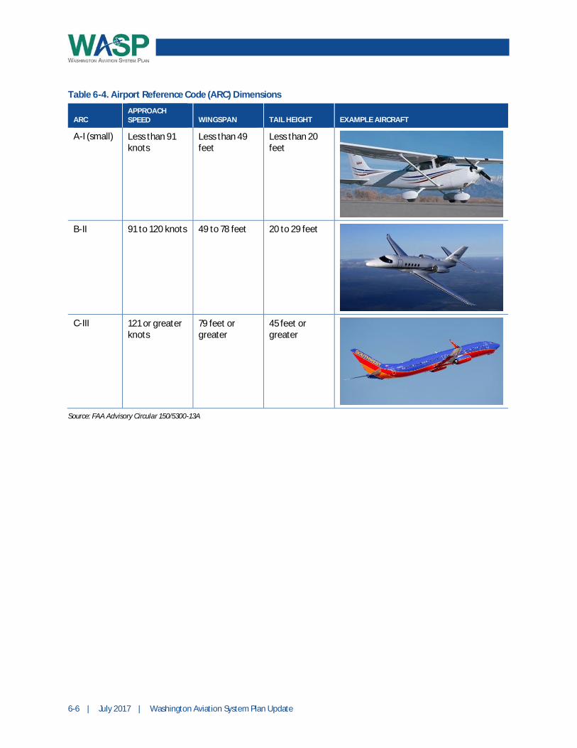
Critical Aircraft is defined by the FAA as the most demanding type of aircraft to conduct at least 500operations a year at an airport. Based on this aircraft’s approach speed to the runway, tail height, andwingspan, an Airport Reference Code (ARC) is assigned and dictates the design standards for the airport.This aircraft is a good indicator of the types of activities that take place or are possible at an airport. It isunlikely airline passengers would be at an airport that is only capable of handling small, light aircraft.Similarly, it is unlikely that these light aircraft are regularly landing at an airport with large commercialjets. Table 6-4 displays the dimensions for the main categories used in the WASP airport classificationcriteria.
6-6 | July 2017 | Washington Aviation System Plan Update
Table 6-4. Airport Reference Code (ARC) Dimensions
ARCAPPROACHSPEED WINGSPAN TAIL HEIGHT EXAMPLE AIRCRAFT
A-I (small) Less than 91knots
Less than 49feet
Less than 20feet
B-II 91 to 120 knots 49 to 78 feet 20 to 29 feet
C-III 121 or greaterknots
79 feet orgreater
45 feet orgreater
Source: FAA Advisory Circular 150/5300-13A

Washington Aviation System Plan Update | July 2017 | 6-7
In addition to evaluating the criteria that are applicable to Washington’s aviation classifications, thenomenclature and number of classifications was reviewed. Five airport classifications were identifiedthrough work with the Advisory Committee. These classifications include Major, Regional, Community,Local, and General Use. The naming of these classifications was tied to the size of the community withinthe airport’s service area, whether it is the population, geographic size, or size of aviation community.Table 6-5 presents a summary of the WASP airport classifications, including the naming convention, theassociated primary activities, and other factors used in classifying the airports.
Table 6-5. WASP Airport Classifications Summary
CLASSIFICATION PRIMARY ACTIVITIES FACTORS TO CLASSIFY AIRPORTS
Major § Commercial service
§ Aircraft or aerospacemanufacturing
§ ARC C-III or greater
§ Primary Activity: commercial service and/oraerospace manufacturing/MRO
§ Population over 40,000
Regional § Corporate GA and travelbusiness
§ ARC B-II or greater
§ Primary Activity: corporate GA and travel business
§ Population over 30,000
Community § GA-personal transportation/business and recreational
§ Pilot training
§ Not metro or regional
§ Paved primary runway surface
§ 15 or more based aircraft
Local § GA-personal transportation/recreational
§ Pilot training
§ Agriculture
§ Not metro or regional
§ Paved primary runway surface
§ Less than 15 based aircraft
General Use § GA-personal transportation/recreational, includingbackcountry
§ Unpaved primary runway surface (including allseaplane bases)
Source: Parsons Brinckerhoff and Kimley-Horn and Associates
Appendix C, Table C-1 presents a listing of airports by classification, and Table C-2 presents analphabetical listing of airports by the associated city while denoting the classification. The followingprovides a more detailed description of each classification.
Major
A Major airport services the general population’s travel needs through commercial service activities andmost likely provides aircraft or aerospace manufacturing. There may be other activities on the airfieldsuch corporate travel, emergency medical, or flight training, but the primary role is commercial travel. Assuch, the main aircraft will tend to be larger with an ARC C-III or greater and the runways will be paved.The service area population must be a minimum of 40,000 but is more likely between 55,000 and 2.2million.

6-8 | July 2017 | Washington Aviation System Plan Update
There are 10 airports classified as Major Airports (all of which are included in the NPIAS) as listed inTable C-1 in Appendix C.
Regional
A Regional airport primarily serves as a base for corporate and business travel via general aviationaircraft and commuter passenger service through the airlines. These trips are typically in smaller aircraft,with an ARC of B-II or greater, and may or may not include scheduled commercial airline service. Thepopulation must be a minimum of 30,000 but is more likely between 34,000 and 2.1 million.
There are 20 airports classified as Regional airports (all of which are included in the NPIAS) as listed inTable C-1 in Appendix C.
Community
A Community airport provides a facility for larger scale general aviation activities that are important toaviation, such as business and personal transportation, recreation, and pilot training. There may be fewercorporate flights for business activities than a Regional airport, but they will still be active at this type ofairport. The typical aircraft serving these activities are ARC A-I (small) to B-II. A Community airportserves a population range of 5,000 to 1.8 million. Community airports have paved runways and shouldhave a minimum of 15 based aircraft to be included in this classification.
There are 35 airports classified as Community airports (18 of which are included in the NPIAS) as listedin Table C-1 in Appendix C.
Local
A Local airport primarily serves GA activities such as personal transportation, recreation, pilot training,and agricultural uses. It is like a Community airport but has less activity or serves a smaller community.Community airports are differentiated by having paved runways with less than 15 based aircraft. Theaircraft will be similar in size to a Community airport, with an ARC of A-I (small) to B-II. The populationserved may range from as little as 3,500 to 1 million people.
There are 37 airports classified as Local airports (14 of which are included in the NPIAS) as listed inTable C-1 in Appendix C.
General Use
All airports without a paved surface are classified as General Use. This classification includes seaplanebases and those airports with turf or other surfaces that are not paved. The same type of aircraft, ARC A-Ito B-II, as Community and Local airport may operate at the airport, but they are primarily for personaltransportation and backcountry activities. There are no minimums for population or based aircraft for thisclassification, but the population can range dramatically from 2,400 to 2.1 million depending on theairport’s location.
There are 34 airports classified as General Use airports (2 of which are included in the NPIAS) as listedin Table C-1 in Appendix C.

Washington Aviation System Plan Update | July 2017 | 6-9
6.3 Airport Metrics
Measuring the system’s performance is an important objective of the WASP. In order to measure thesystem’s performance, evaluating each airport’s contributions to the system and how each airport impactsthe overall system’s performance must be determined. The airport classifications allow for the establish-ment of metrics that are obtainable for the individual airports based on their classification or role andcontribution to the system. It is not reasonable to assume that an airport with limited resources andactivity should be held to the same standards or performance as an airport with greater resources andsignificant annual activity. Individual airport metrics can be compiled to evaluate the overall system’sperformance and determine adequacies, deficiencies, and redundancies.
For the WASP, metrics were developed relative to each system goal category. Some of the metrics areeasily quantifiable, such as the pavement condition index (PCI), while others may be actions the airportneeds to take, such as analyzing how well the airport meets FAA design standards. Some of the metricsare also important to serve as minimum standards for the system’s development, while others arerecommended to serve as minimums to strive to achieve.
The following presents the Airport Metrics by goal category, as well as specific metrics associated witheach classification.
Aeronautical Airport Safety
Aeronautical and Airport Safety is intended to ensure airports are operating safely andefficiently. The objectives of this goal include attaining and maintaining the WSDOTPerformance Objectives and Standards and the FAA Design Standards as well as, more specifically,maintaining safe and clear approaches. Based on this, two metrics derived from FAA Design Standardswere established to measure the system’s performance of the Aeronautical Airport Safety goal.
The FAA Design Standards facilitate the public interest requirement to develop and maintain a nationalsystem of safe, delay-free, and cost-effective airports through publications of advisory circulars andorders. The standards and recommendations represent the most effective national approach for meetingthe long-term aviation demand in a manner that is consistent with national policy, with safety being thehighest priority. Every effort should be made to bring an obligated airport in line with the existingstandards not only for safety purposes but also because federal funding may be dependent on it.

6-10 | July 2017 | Washington Aviation System Plan Update
The Obstructions Metric (Table 6-6) includes, at minimum, ensuring the Runway Safety Area (RSA)2 andthe Threshold Siting Surfaces (TSS)3 are clear of obstructions for all runway ends at all classifications ofairports. The target is to ensure that the ultimate approach, whether it is with a runway extension or lowervisibility minimums, is also clear so there are no obstructions to the future development. The existing andrequired dimensions of the RSA and TSS can be found on the airport’s Airport Layout Plan (ALP).
Table 6-6. Aeronautical and Airport Safety Metric: Obstructions
CLASSIFICATION DESCRIPTION MINIMUM STANDARD TARGET
I Major Clear runway safety area andthreshold siting surface for allrunway ends
Clear runway safety area andthreshold siting surface for allrunway ends, and clear obstructionsto achieve airport’s identifiedultimate approach capability
II Regional Clear runway safety area andthreshold siting surface for primaryrunway ends
Clear runway safety area andthreshold siting surface for allrunway ends, and clear obstructionsto achieve airport’s identifiedultimate approach capability
III Community Clear runway safety area andthreshold siting surface for primaryrunway ends
Clear runway safety area andthreshold siting surface for allrunway ends, and clear obstructionsto achieve airport’s identifiedultimate approach capability
IV Local Clear runway safety area andthreshold siting surface for primaryrunway ends
Clear runway safety area andthreshold siting surface for allrunway ends, and clear obstructionsto achieve airport’s identifiedultimate approach capability
V General Use Clear runway safety area andthreshold siting surface for primaryrunway ends
Clear runway safety area andthreshold siting surface for allrunway ends, and clear obstructionsto achieve airport’s identifiedultimate approach capability
2 The Runway Safety Area is a defined surface surrounding the runway prepared or suitable for reducing the risk ofdamage to aircraft in the event of an undershoot, overshoot, or excursion from the runway.3 The Threshold Siting Surfaces ensure compatibility between nearby objects and the runway’s threshold, which isdefined as the first part of pavement available and suitable for landing.

Washington Aviation System Plan Update | July 2017 | 6-11
The Weather Services Metric (Table 6-7) displays the type of weather systems that should be utilized bythe airports based on the classification. Smaller airports, such as General Use, Local, and Community,should ideally have an on-site weather reporting system such as an Automated Weather ObservationSystem (AWOS) or Automated Surface Observation System (ASOS).4 Major and Regional airportsshould have a weather system on-site at a minimum, but ideally also provide an Automated TerminalInformation System (ATIS) to pilots. The ATIS provides hourly recorded essential aeronauticalinformation, such as weather, active runways, available approaches, Notices to Airmen, and otherpertinent information.
Table 6-7. Aeronautical and Airport Safety Metric: Weather Services
CLASSIFICATION DESCRIPTION MINIMUM STANDARD TARGET
I Major On-site weather reporting (AWOS,ASOS)
On-site weather reporting (AWOS,ASOS, ATIS)
II Regional On-site weather reporting (AWOS,ASOS)
On-site weather reporting (AWOS,ASOS, ATIS)
III Community Not required On-site weather reporting
IV Local Not required On-site weather reporting
V General Use Not required On-site weather reporting
4 AWOS are mostly operated, maintained, and controlled by FAA. ASOS are operated and controlled cooperativelyby FAA, National Weather Service, and Department of Defense.

6-12 | July 2017 | Washington Aviation System Plan Update
The Airfield Geometry Design Standards Metric (Table 6-8) sets the minimum standard for all NPIASairports to meet FAA airfield geometry design standards. The FAA promotes standards andrecommendations to support their policies as promulgated by the United States Code. The FAA-obligatedNPIAS airports are required to meet FAA standards and, as appropriate and eligible, can work with FAAto apply for a modification of standard for certain conditions. FAA defines a modification to standard as“any approved nonconformance to FAA standards, other than dimensional standards for Runway SafetyAreas (RSAs), applicable to an airport design, construction, or equipment procurement project that isnecessary to accommodate an unusual local condition for a specific project on a case-by-case basis whilemaintaining an acceptable level of safety.” The target for NPIAS airports is to meet the FAA designstandard for their Airport Reference Code.
In addition, WSDOT plans to develop state standards that best align with the airport classification and thenecessary infrastructure associated with the standards. These standards have not yet been established, butif the state standards are greater than FAA standards, all airports would need to comply with statestandards. These state standards would be the only ones applicable to the non-NPIAS airports. The targetfor non-NPIAS airports is to meet the state design standards without modification of standards.
Initially, it is anticipated that WSDOT’s state standards will focus on the RSA, widths of runway andtaxiways, separation standards, and airspace obstructions. The existing and recommended dimensions ofthe design standards can be found on the airport’s ALP.
Table 6-8. Aeronautical and Airport Safety Metric: Airfield Geometry Design Standards
CLASSIFICATION DESCRIPTION MINIMUM STANDARD* TARGET*
I Major Meet FAA/state design standards forAirport Reference Code
Meet FAA/state design standards forAirport Reference Code
II Regional Meet FAA/state design standards forAirport Reference Code
Meet FAA/state design standards forAirport Reference Code
III Community Meet FAA/state design standards forAirport Reference Code
Meet FAA/state design standards forAirport Reference Code
IV Local Meet FAA/state design standards forAirport Reference Code
Meet FAA/state design standards forAirport Reference Code
V General Use Meet FAA/state design standards forAirport Reference Code
Meet FAA/state design standards forAirport Reference Code
*Includes Runway Safety Area, runway/taxiway width, runway/taxiway separation standards

Washington Aviation System Plan Update | July 2017 | 6-13
Economic Development and Vitality
Economic Development and Vitality ensures the airport is advancing the businessopportunities of the airport and its surrounding community. The objectives includesupporting and increasing the opportunity of the transportation of goods andpassengers utilizing air service, enhancing collaboration between the airport and its community tomaintain and support economic growth and development, and increasing tenant revenues by promotingon-airport businesses and aerospace manufacturing jobs.
Table 6-9 sets the recommended minimum and target for the Collaboration with Government Agencies onEconomic Opportunities Metric for all classifications of airports in the WASP. The recommendedminimum includes collaborating with state and local agencies, such as the local chamber of commerce,economic development commission, or tourism bureau. The target is to have a documented plan andmonitor these efforts. Table 6-10 displays a similar metric for Partner with Industry to Support Activities.As with the collaboration on economic opportunities metric, the recommended minimum is to collaboratewith businesses to support activities and the target is to document and monitor the efforts for allclassifications of airports.
Table 6-9. Economic Development and Vitality Metric: Collaboration with Government Agencies onEconomic Opportunities
CLASSIFICATION DESCRIPTION RECOMMENDED MINIMUM TARGET
I Major Collaborate with state & localagencies to document economic andqualitative contributions of aviation
Documented plan for collaborationefforts; track and monitor efforts andresults
II Regional Collaborate with state & localagencies to document economic andqualitative contributions of aviation
Documented plan for collaborationefforts; track and monitor efforts andresults
III Community Collaborate with state & localagencies to document economic andqualitative contributions of aviation
Documented plan for collaborationefforts; track and monitor efforts andresults
IV Local Collaborate with state & localagencies to document economic andqualitative contributions of aviation
Documented plan for collaborationefforts; track and monitor efforts andresults
V General Use Collaborate with state & localagencies to document economic andqualitative contributions of aviation
Documented plan for collaborationefforts; track and monitor efforts andresults

6-14 | July 2017 | Washington Aviation System Plan Update
Table 6-10. Economic Development and Vitality Metric: Partner with Industry to Support Activities
CLASSIFICATION DESCRIPTION RECOMMENDED MINIMUM TARGET
I Major Collaboration with businesses tosupport airport activities
Documented plan for collaborationefforts; track and monitor efforts andresults
II Regional Collaboration with businesses tosupport airport activities
Documented plan for collaborationefforts; track and monitor efforts andresults
III Community Collaboration with businesses tosupport airport activities
Documented plan for collaborationefforts; track and monitor efforts andresults
IV Local Collaboration with businesses tosupport airport activities
Documented plan for collaborationefforts; track and monitor efforts andresults
V General Use Collaboration with businesses tosupport airport activities
Documented plan for collaborationefforts; track and monitor efforts andresults
The Air Cargo Activity Report Metric (Table 6-11) provides recommended minimums and targetsregarding tracking activity, managing air cargo support services and facilities, and collaborating withother agencies to expand air cargo opportunities based on the classification of airport. A Major airport istargeted to collaborate with WSDOT on facility and policy needs related to air cargo, outside agencies forconnections to off-airport activity such as an airport logistic park, and track and report cargo activitystatistics. Smaller Community and Local airports should be tracking the activity and discussing needs withWSDOT.

Washington Aviation System Plan Update | July 2017 | 6-15
Table 6-11. Economic Development and Vitality Metric: Cargo Activity Reporting
CLASSIFICATION DESCRIPTION RECOMMENDED MINIMUM TARGET
I Major Track and annually report aircargo/freight activity (such asnumber of operations, tonnage, typeof freight carried) to WSDOT;manage off-airport resources for aircargo support services (such as cross-dock trucking, warehouse, etc.);examine feasibility of establishingairport logistics parks
Collaborate with WSDOT on aircargo facility and policy needs, andinvestment strategies, identified as aresult of reported activity;collaborate with regional planningand economic development agencieson off-airport resource development
II Regional Track and annually report aircargo/freight activity (such asnumber of operations, tonnage, typeof freight carried) to WSDOT;identify off-airport resources for aircargo support services
Collaborate with WSDOT on aircargo facility and policy needs, andinvestment strategies, identified as aresult of reported activity;collaborate with regional planningand economic development agencieson off-airport resource development
III Community Track and report air cargo/freightactivity (such as number ofoperations, tonnage, type of freightcarried) to WSDOT
Collaborate with WSDOT on aircargo facility and policy needs, andinvestment strategies, identified as aresult of reported activity
IV Local Track and report air cargo/freightactivity (such as number ofoperations, tonnage, type of freightcarried) to WSDOT
Collaborate with WSDOT on aircargo facility and policy needs, andinvestment strategies, identified as aresult of reported activity
V General Use Track and report air cargo/freightactivity (such as number ofoperations, tonnage, type of freightcarried) to WSDOT
Collaborate with WSDOT on aircargo facility and policy needs, andinvestment strategies, identified as aresult of reported activity
Education, Outreach, and Community Engagement
Education, Outreach, and Community Engagement is intended to promote aviationand its importance, impact, and activities. The objectives include promoting aviationeducation to enhance safety and community support, increasing community knowledge of the aviationsystems to communicate airport benefit and contribution to local communities and economies, andpromoting aviation activities matched to community needs.
6-16 | July 2017 | Washington Aviation System Plan Update
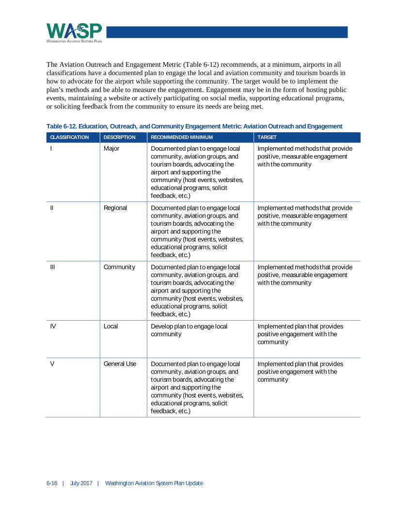
The Aviation Outreach and Engagement Metric (Table 6-12) recommends, at a minimum, airports in allclassifications have a documented plan to engage the local and aviation community and tourism boards inhow to advocate for the airport while supporting the community. The target would be to implement theplan’s methods and be able to measure the engagement. Engagement may be in the form of hosting publicevents, maintaining a website or actively participating on social media, supporting educational programs,or soliciting feedback from the community to ensure its needs are being met.
Table 6-12. Education, Outreach, and Community Engagement Metric: Aviation Outreach and Engagement
CLASSIFICATION DESCRIPTION RECOMMENDED MINIMUM TARGET
I Major Documented plan to engage localcommunity, aviation groups, andtourism boards, advocating theairport and supporting thecommunity (host events, websites,educational programs, solicitfeedback, etc.)
Implemented methods that providepositive, measurable engagementwith the community
II Regional Documented plan to engage localcommunity, aviation groups, andtourism boards, advocating theairport and supporting thecommunity (host events, websites,educational programs, solicitfeedback, etc.)
Implemented methods that providepositive, measurable engagementwith the community
III Community Documented plan to engage localcommunity, aviation groups, andtourism boards, advocating theairport and supporting thecommunity (host events, websites,educational programs, solicitfeedback, etc.)
Implemented methods that providepositive, measurable engagementwith the community
IV Local Develop plan to engage localcommunity
Implemented plan that providespositive engagement with thecommunity
V General Use Documented plan to engage localcommunity, aviation groups, andtourism boards, advocating theairport and supporting thecommunity (host events, websites,educational programs, solicitfeedback, etc.)
Implemented plan that providespositive engagement with thecommunity

Washington Aviation System Plan Update | July 2017 | 6-17
Infrastructure Improvement, Preservation, and Capacity
Infrastructure Improvement, Preservation, and Capacity is focused on ensuring theexisting system is maintained and improved to handle the current and forecastedcapacity. The objectives include providing access for aircraft during all weatherconditions, maintaining the facilities to established classification levels, and planning to meet emergingrequirements in technology and infrastructure, such as NextGen.
The Physical Condition of Infrastructure Metric (Table 6-13) is based on the industry standard PavementCondition Index (PCI). Pavement can be assessed following the ASTM Standard D5340, Standard TestMethod for Airport Pavement Condition Index Surveys. PCI values range from 0 (failed) to 100(excellent).
Table 6-13. Infrastructure Improvement, Preservation, and Capacity Metric: Physical Condition ofInfrastructure
CLASSIFICATION DESCRIPTION MINIMUM STANDARD* TARGET*
I Major Runways PCI >70 (AC) or >60 (PCC) Runways PCI >70 (AC) or >60 (PCC);taxiways PCI>65 (AC) or >55 (PCC);other pavements PCI >60 (AC) or >50(PCC)
II Regional Runways PCI >65 (AC) or >55 (PCC) Runways PCI >65 (AC) or >55 (PCC);taxiways and other pavementsPCI>60 (AC) or >50 (PCC)
III Community Runways PCI >65 (AC) or >55 (PCC) Runways PCI >65 (AC) or >55 (PCC);taxiways and other pavementsPCI>60 (AC) or >50 (PCC)
IV Local Runways PCI >65 (AC) or >55 (PCC) Runways PCI >65 (AC) or >55 (PCC);taxiways and other pavementsPCI>60 (AC) or >50 (PCC)
V General Use Not applicable Not applicable
*AC = asphalt concrete; PCC = Portland cement concrete
Figure 6-1 provides examples of pavement in poor and good condition. Pavement condition is a majorsafety component at an airport as it directly impacts the capability of the runway surface to provide asuitable environment for maintaining aircraft directional control. Pavement in poor condition can damageaircraft through prop strikes or foreign object debris being swept up from the ground into an aircraft. It isalso important to maintain pavement regularly as repairs become costlier the longer maintenance isdeferred. As General Use airports are unpaved surfaces, this Metric does not apply to them. Local,Community, and Regional airports should have a PCI of 55 or greater if using Portland cement concrete(PCC) or 65 or greater if using asphalt concrete (AC). Major airports have a higher standard of 60 orgreater for PCC and 70 or greater for AC. The Target PCIs for runways, taxiways, and other pavementareas are shown in Table 6-13.

6-18 | July 2017 | Washington Aviation System Plan Update
Figure 6-1. Example of Pavement Conditions
PAVEMENT IN POOR CONDITION PAVEMENT IN GOOD CONDITION
Airport Capacity Metric (Table 6-14) recommends that all classifications of airports have the ability tomeet their current storage requirements. Community, Regional, and Major airports should ensure they arenot exceeding 80 percent of their current airfield capacity. Airfield capacity can be defined as either ameasure of maximum sustainable throughput or as the number of aircraft operations that can beaccommodated with a specified maximum average delay. Airfield capacity is determined based on theavailable airfield system and a range of airport characteristics, including the types and numbers of aircraftoperations.
Targets for airport capacity include providing storage for future aircraft based on forecasts for allclassifications and not exceeding 60 percent of the airfield capacity for Community, Regional, and Majorairports.
Table 6-14. Infrastructure Improvement, Preservation, and Capacity Metric: Airport Capacity
CLASSIFICATION DESCRIPTION RECOMMENDED MINIMUM* TARGET*
I Major Airfield capacity <80% and sufficientaircraft storage capacity
Airfield capacity <60% and land forfuture aircraft storage capacity
II Regional Airfield capacity <80% and sufficientaircraft storage capacity
Airfield capacity <60% and land forfuture aircraft storage capacity
III Community Airfield capacity <80% and sufficientaircraft storage capacity
Airfield capacity <60% and land forfuture aircraft storage capacity
IV Local Sufficient aircraft storage capacity Land for future aircraft storagecapacity
V General Use Sufficient aircraft storage capacity Area for future aircraft storagecapacity
* Airfield Capacity can be either Annual Service Volume or Hourly Capacity

Washington Aviation System Plan Update | July 2017 | 6-19
Aviation Innovation
Aviation Innovation is aimed at supporting new technologies and processes relatedto aviation with objectives in supporting innovation in the aviation system andaeronautics. The primary purpose of this metric is to foster, embrace, and enableaviation innovation through monitoring emerging innovation opportunities, providing support, andcommunicating the opportunities to engage WSDOT’s support. The recommended minimum for theIntegration of Aviation Innovation Metric (Table 6-15) is to track and report on the activities and projectsbeing completed by the airport that support the integration of these innovative projects with an ultimatetarget of increasing the activities and projects over the years. The activities include fostering andenabling, while infrastructure projects could include ensuring the electrical system is built to a standardthat allows for additional navigational aids, constructing natural gas fueling locations for the shuttles, orparticipating in a research study. By supporting and partnering in the research and advancement of thetechnologies through industry providers, aviation-related associations, and academia, sponsors can stayinformed and potentially be involved in evolving programs.
Table 6-15. Aviation Innovation Metric: Integration of Aviation Innovation
CLASSIFICATION DESCRIPTION RECOMMENDED MINIMUM TARGET
I Major Track and report activities andprojects that support integration ofaviation innovation (NextGen,alternative fuels)
Increase activities and projects thatsupport integration of aviationinnovation
II Regional Track and report activities andprojects that support integration ofaviation innovation (NextGen,alternative fuels)
Increase activities and projects thatsupport integration of aviationinnovation
III Community Track and report activities andprojects that support integration ofaviation innovation (NextGen,alternative fuels)
Increase activities and projects thatsupport integration of aviationinnovation
IV Local Track and report activities andprojects that support integration ofaviation innovation (NextGen,alternative fuels)
Increase activities and projects thatsupport integration of aviationinnovation
V General Use Track and report activities andprojects that support integration ofaviation innovation (NextGen,alternative fuels)
Increase activities and projects thatsupport integration of aviationinnovation

6-20 | July 2017 | Washington Aviation System Plan Update
Modal Mobility, Capacity, and Accessibility
Modal Mobility, Capacity, and Accessibility is intended to ensure the airport is easilyaccessible by the general public. Regional access to airports has been identified as areoccurring problem across the nation as airports are not always considered in theregional transportation planning process. Objectives include providing adequate ground access to andfrom the airport, supporting road capacity access initiatives, and supporting and improving multimodalconnections. The Ground Access Metric (Table 6-16) recommends a certain level of accessibility to theairport. It recommends ensuring there is adequate parking for users and tenants, ensuring users are able tofind their way to the airport when departing and to their destination when arriving through signage, carrental, or multiple modes of public transportation.
Table 6-16. Modal Mobility, Capacity, and Accessibility Metric: Ground Access
CLASSIFICATION DESCRIPTION RECOMMENDED MINIMUM TARGET
I Major Collaborate with regional transpor-tation and business partners to reducedelay and provide sufficient roadaccess on key routes, address parkingdemand, provide adequate directionalsignage, and coordinate with publictransit and transportation for hire
Optimize road access capacity,provide sufficient parkingcapacity, enhanced directionalsignage, collaborate with publictransit and transportation for hire
II Regional Collaborate with regional transpor-tation and business partners to reducedelay and provide sufficient roadaccess on key routes, address parkingdemand, provide adequate directionalsignage, and coordinate with publictransit and transportation for hire
Optimize road access capacityprovide sufficient parkingcapacity, enhanced directionalsignage, collaborate with publictransit and transportation for hire
III Community Collaborate with regional transpor-tation and business partners to reducedelay and provide sufficient roadaccess on key routes, address parkingdemand, provide adequate directionalsignage, and coordinate with publictransit and transportation for hire
Optimize road access capacity,provide sufficient parkingcapacity, enhanced directionalsignage, collaborate with publictransit and transportation for hire
IV Local Sufficient road access capacity andadequate directional signage
Sufficient road access capacityand adequate directional signage
V General Use Sufficient road access capacity andadequate directional signage
Sufficient road access capacityand adequate directional signage
Washington Aviation System Plan Update | July 2017 | 6-21
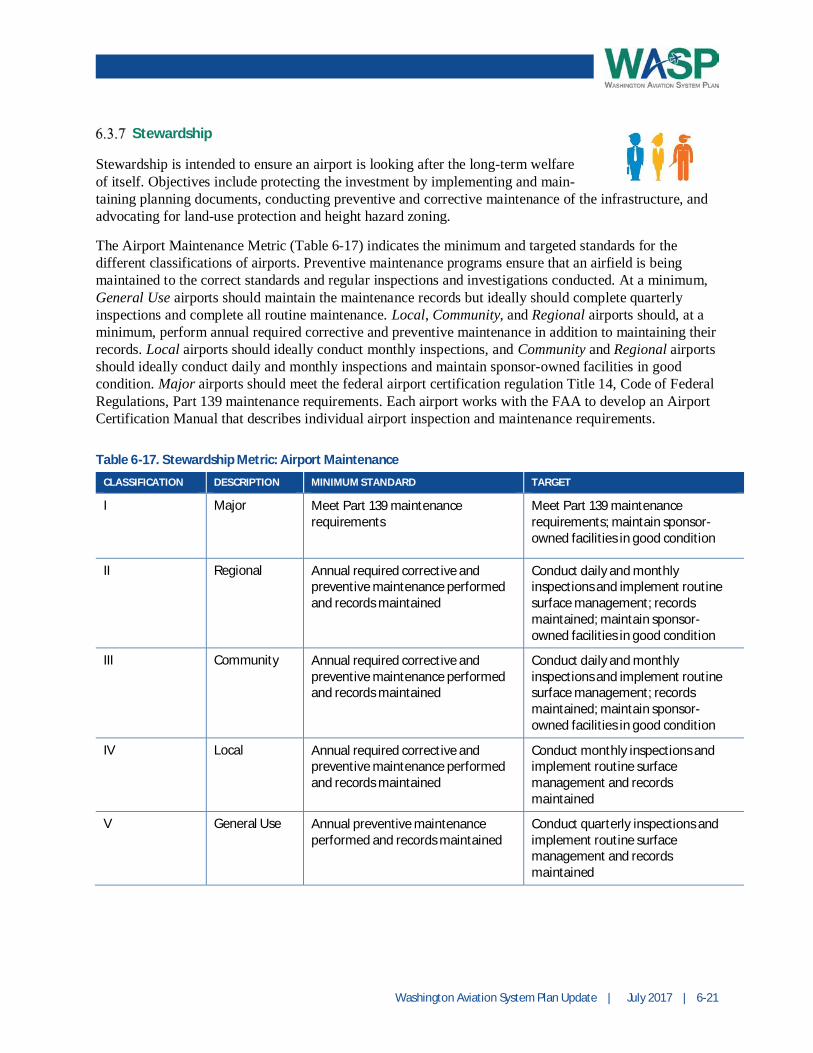
Stewardship
Stewardship is intended to ensure an airport is looking after the long-term welfareof itself. Objectives include protecting the investment by implementing and main-taining planning documents, conducting preventive and corrective maintenance of the infrastructure, andadvocating for land-use protection and height hazard zoning.
The Airport Maintenance Metric (Table 6-17) indicates the minimum and targeted standards for thedifferent classifications of airports. Preventive maintenance programs ensure that an airfield is beingmaintained to the correct standards and regular inspections and investigations conducted. At a minimum,General Use airports should maintain the maintenance records but ideally should complete quarterlyinspections and complete all routine maintenance. Local, Community, and Regional airports should, at aminimum, perform annual required corrective and preventive maintenance in addition to maintaining theirrecords. Local airports should ideally conduct monthly inspections, and Community and Regional airportsshould ideally conduct daily and monthly inspections and maintain sponsor-owned facilities in goodcondition. Major airports should meet the federal airport certification regulation Title 14, Code of FederalRegulations, Part 139 maintenance requirements. Each airport works with the FAA to develop an AirportCertification Manual that describes individual airport inspection and maintenance requirements.
Table 6-17. Stewardship Metric: Airport Maintenance
CLASSIFICATION DESCRIPTION MINIMUM STANDARD TARGET
I Major Meet Part 139 maintenancerequirements
Meet Part 139 maintenancerequirements; maintain sponsor-owned facilities in good condition
II Regional Annual required corrective andpreventive maintenance performedand records maintained
Conduct daily and monthlyinspections and implement routinesurface management; recordsmaintained; maintain sponsor-owned facilities in good condition
III Community Annual required corrective andpreventive maintenance performedand records maintained
Conduct daily and monthlyinspections and implement routinesurface management; recordsmaintained; maintain sponsor-owned facilities in good condition
IV Local Annual required corrective andpreventive maintenance performedand records maintained
Conduct monthly inspections andimplement routine surfacemanagement and recordsmaintained
V General Use Annual preventive maintenanceperformed and records maintained
Conduct quarterly inspections andimplement routine surfacemanagement and recordsmaintained

6-22 | July 2017 | Washington Aviation System Plan Update
The Planning Metric (Table 6-18) is based on the type of planning document to be used to guide futureairport development. The Airport Master Plan and Airport Layout Plan (ALP) are comprehensiveanalyses of an airport that ultimately illustrate the short- and long-term development plans to meet thefuture aviation demand requirements.
ALPs are generally needed for airports with less than 50 based aircraft, lower activity levels, and nounusual activity. As such, General Use airports should, at a minimum, to complete an ALP, and, Local,and Community both an ALP and Master Plan. Regional and Major airports should have completed amaster plan, ideally within the past 5 to 7 years. These documents should be reviewed every 10 years, at aminimum, for applicability to the current goals and conditions of the airport. Additionally, a review ofobstructions and survey effort through Airport Geographic Information System (AGIS) should becompleted to assist in the national data collection and analysis effort.
Table 6-18. Stewardship Metric: Planning
CLASSIFICATION DESCRIPTION MINIMUM STANDARD TARGET
I Major Master Plan (last 10 years) Review Master Plan (5 years), AGISSurvey/Evaluation (5 years), eALPand update plans as needed
II Regional Master Plan (last 10 years) Review Master Plan (7 years), AGISSurvey/Evaluation (7 years), eALPand update plans as needed
III Community Master Plan and ALP Review Master Plan (10 years), AGISSurvey/Evaluation (10 years), andupdate plans as needed
IV Local Master Plan and ALP Review Master Plan (10 years), AGISSurvey/Evaluation (10 years), andupdate plans as needed
V General Use ALP Review Master Plan (10 years) andObstructions and update plans asneeded
The Land Use Metric (Table 6-19) encourages municipalities to address protection of airports and theirfuture improvements in in the future land use, transportation, intergovernmental coordination, and capitalimprovement program elements of their local government comprehensive plan. This may includeadopting land use compatibility and height hazard zoning into the municipal code. Ideally, there shouldbe no new incompatible land uses near an airport and the municipalities work with the airport to promotecompatible uses.

Washington Aviation System Plan Update | July 2017 | 6-23
Table 6-19. Stewardship Metric: Land Use
CLASSIFICATION DESCRIPTION RECOMMENDED MINIMUM TARGET
I Major Airports integrated into localcomprehensive andtransportation plans, policies anddevelopment regulations thatdiscourage development ofincompatible land uses within theairport influence area, andadoption of Overlay Zones 1-6
No additional incompatible land usesintroduced in airport influence areaand promotion of compatible andcomplimentary land uses
II Regional Airports integrated into localcomprehensive andtransportation plans, policies anddevelopment regulations thatdiscourage development ofincompatible land uses within theairport influence area, andadoption of Overlay Zones 1-6
No additional incompatible land usesintroduced in airport influence areaand promotion of compatible andcomplimentary land uses
III Community Airports integrated into localcomprehensive andtransportation plans, policies anddevelopment regulations thatdiscourage development ofincompatible land uses within theairport influence area, andadoption of Overlay Zones 1-6
No additional incompatible land usesintroduced in airport influence areaand promotion of compatible andcomplimentary land uses
IV Local Airports integrated into localcomprehensive andtransportation plans, policies anddevelopment regulations thatdiscourage development ofincompatible land uses within theairport influence area, andadoption of Overlay Zones 1-6
No additional incompatible land usesintroduced in airport influence areaand promotion of compatible andcomplimentary land uses
V General Use Airports integrated into localcomprehensive andtransportation plans, policies anddevelopment regulations thatdiscourage development ofincompatible land uses within theairport influence area, andadoption of Overlay Zones 1-6
No additional incompatible land usesintroduced in airport influence areaand promotion of compatible andcomplimentary land uses
The Emergency Response Plan Metric (Table 6-20) recommends that airports have an emergencyresponse plan in case an emergency happens at the airport utilizing nonairport first responders. The target
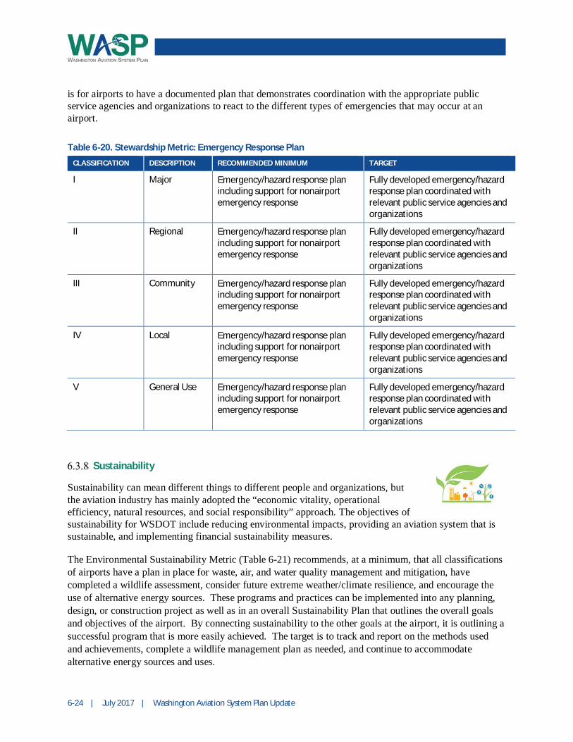
6-24 | July 2017 | Washington Aviation System Plan Update
is for airports to have a documented plan that demonstrates coordination with the appropriate publicservice agencies and organizations to react to the different types of emergencies that may occur at anairport.
Table 6-20. Stewardship Metric: Emergency Response Plan
CLASSIFICATION DESCRIPTION RECOMMENDED MINIMUM TARGET
I Major Emergency/hazard response planincluding support for nonairportemergency response
Fully developed emergency/hazardresponse plan coordinated withrelevant public service agencies andorganizations
II Regional Emergency/hazard response planincluding support for nonairportemergency response
Fully developed emergency/hazardresponse plan coordinated withrelevant public service agencies andorganizations
III Community Emergency/hazard response planincluding support for nonairportemergency response
Fully developed emergency/hazardresponse plan coordinated withrelevant public service agencies andorganizations
IV Local Emergency/hazard response planincluding support for nonairportemergency response
Fully developed emergency/hazardresponse plan coordinated withrelevant public service agencies andorganizations
V General Use Emergency/hazard response planincluding support for nonairportemergency response
Fully developed emergency/hazardresponse plan coordinated withrelevant public service agencies andorganizations
Sustainability
Sustainability can mean different things to different people and organizations, butthe aviation industry has mainly adopted the “economic vitality, operationalefficiency, natural resources, and social responsibility” approach. The objectives ofsustainability for WSDOT include reducing environmental impacts, providing an aviation system that issustainable, and implementing financial sustainability measures.
The Environmental Sustainability Metric (Table 6-21) recommends, at a minimum, that all classificationsof airports have a plan in place for waste, air, and water quality management and mitigation, havecompleted a wildlife assessment, consider future extreme weather/climate resilience, and encourage theuse of alternative energy sources. These programs and practices can be implemented into any planning,design, or construction project as well as in an overall Sustainability Plan that outlines the overall goalsand objectives of the airport. By connecting sustainability to the other goals at the airport, it is outlining asuccessful program that is more easily achieved. The target is to track and report on the methods usedand achievements, complete a wildlife management plan as needed, and continue to accommodatealternative energy sources and uses.
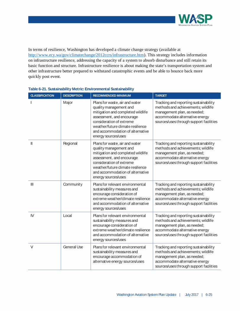
Washington Aviation System Plan Update | July 2017 | 6-25
In terms of resilience, Washington has developed a climate change strategy (available athttp://www.ecy.wa/gov/climatechange/2012ccrs/infrastructure.htm). This strategy includes informationon infrastructure resilience, addressing the capacity of a system to absorb disturbance and still retain itsbasic function and structure. Infrastructure resilience is about making the state’s transportation system andother infrastructure better prepared to withstand catastrophic events and be able to bounce back morequickly post event.
Table 6-21. Sustainability Metric: Environmental Sustainability
CLASSIFICATION DESCRIPTION RECOMMENDED MINIMUM TARGET
I Major Plans for waste, air and waterquality management andmitigation and completed wildlifeassessment, and encourageconsideration of extremeweather/future climate resilienceand accommodation of alternativeenergy sources/uses
Tracking and reporting sustainabilitymethods and achievements; wildlifemanagement plan, as needed;accommodate alternative energysources/uses through support facilities
II Regional Plans for waste, air and waterquality management andmitigation and completed wildlifeassessment, and encourageconsideration of extremeweather/future climate resilienceand accommodation of alternativeenergy sources/uses
Tracking and reporting sustainabilitymethods and achievements; wildlifemanagement plan, as needed;accommodate alternative energysources/uses through support facilities
III Community Plans for relevant environmentalsustainability measures andencourage consideration ofextreme weather/climate resilienceand accommodation of alternativeenergy sources/uses
Tracking and reporting sustainabilitymethods and achievements; wildlifemanagement plan, as needed;accommodate alternative energysources/uses through support facilities
IV Local Plans for relevant environmentalsustainability measures andencourage consideration ofextreme weather/climate resilienceand accommodation of alternativeenergy sources/uses
Tracking and reporting sustainabilitymethods and achievements; wildlifemanagement plan, as needed;accommodate alternative energysources/uses through support facilities
V General Use Plans for relevant environmentalsustainability measures andencourage accommodation ofalternative energy sources/uses
Tracking and reporting sustainabilitymethods and achievements; wildlifemanagement plan, as needed;accommodate alternative energysources/uses through support facilities

6-26 | July 2017 | Washington Aviation System Plan Update
The Land Use Control Metric (Table 6-22) recommends that the airport sponsor control the land use inthe Federal Aviation Regulation Part 77 Imaginary Surfaces. Ideally, there should be no incompatibleuses in these areas. These surfaces are based on the Safe, Efficient Use, and Preservation of the NavigableAirspace and include horizontal, conical, primary, approach, and transitional surfaces. These surfacesmay be found in the ALP drawing set.
Table 6-22. Sustainability Metric: Land Use Controls
CLASSIFICATION DESCRIPTION RECOMMENDED MINIMUM TARGET
I Major Land Use Control of Part 77 Surfaces No Incompatible Uses in Part 77
II Regional Land Use Control of Part 77 Surfaces No Incompatible Uses in Part 77
III Community Land Use Control of Part 77 Surfaces No Incompatible Uses in Part 77
IV Local Land Use Control of Part 77 Surfaces No Incompatible Uses in Part 77
V General Use Land Use Control of Part 77 Surfaces No Incompatible Uses in Part 77
The Financial Sustainability Metric (Table 6-23) is a key topic for many airports as they strive to becomeself-sufficient or continue to provide their local share of the funds for development projects. At aminimum, all classifications of airports should conduct a business plan to ensure they are choosingdevelopment projects that give them the best returns on their investments, charging the correct rates,operating and marketing the airport properly and efficiently, and reviewing additional sources of revenue.Ideally, the business plan would be reviewed every five years and updated as necessary. Additionally,airports should report on the success and failures of the recommendations from the business plan.
Table 6-23. Sustainability Metric: Financial Sustainability
CLASSIFICATION DESCRIPTION MINIMUM STANDARD TARGET
I Major Business plan Review business plan every 5 years and update asneeded; report on implementation ofrecommendations
II Regional Business plan Review business plan every 5 years and update asneeded; report on implementation ofrecommendations
III Community Business plan Review business plan every 5 years and update asneeded; report on implementation ofrecommendations
IV Local Business plan Review business plan every 5 years and update asneeded; report on implementation ofrecommendations
V General Use Business planrecommended
Review business plan and update as needed
Washington Aviation System Plan Update | July 2017 | 6-27
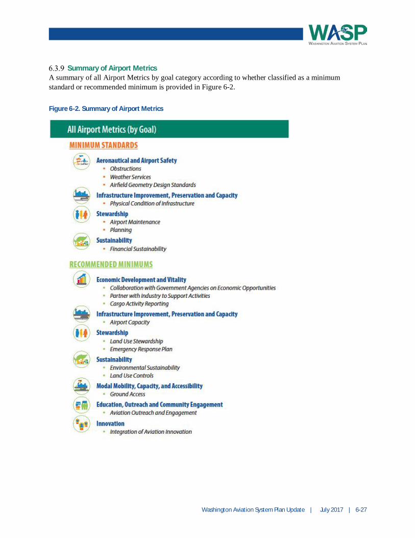
Summary of Airport MetricsA summary of all Airport Metrics by goal category according to whether classified as a minimumstandard or recommended minimum is provided in Figure 6-2.
Figure 6-2. Summary of Airport Metrics

6-28 | July 2017 | Washington Aviation System Plan Update
6.4 NPIAS Classifications and Evaluation
The FAA’s classification system of airports is important from the perspective that airports included in theNPIAS are deemed by FAA to be important to the national system of airports and are typically eligible toapply for federal funding for certain project types. For the most part, the NPIAS has consisted of publiclyowned, public-use airports, although in some states there are privately owned, public-use airports thathave been deemed important to the state and national systems. Approximately 65 percent of the publiclanding facilities in the U.S. are in the NPIAS. As part of the WASP, the eligibility criteria for airports notcurrently included in the federal aviation system were reviewed.
As previously presented, airports are first categorized as primary or nonprimary. Primary airports are thecommercial service airports, served by airlines that provide service to the general public with more than10,000 boardings or enplaned passengers per year (enplanements). These primary commercial serviceairports are categorized into nonhub, small, medium, or large hub based on the percentage of thepassengers they handle annually. Nonprimary commercial service airports serve less than 10,000enplanements per year.
Due to the different operating characteristics between larger commercial and smaller GA aircraft, GAoperations, especially single-engine propeller aircraft, typically prefer and use noncommercial airports tothe extent possible. GA airports are considered nonprimary.
Airports that are officially designated to relieve commercial airports from GA traffic are referred to asRelievers in the NPIAS. They must have at least 100 based aircraft or 25,000 annual itinerant operations,provide access to the overall community, and support a metropolitan commercial service airport that has apopulation of at least 250,000 or has at least 250,000 enplanements and that is operating at least 60percent of its operational capacity.
To further address the roles and characteristics of GA airports, the FAA developed the Asset Study.5 TheFAA classified all GA airports currently in the NPIAS into groups, including National, Regional, Local,and Basic, depending on the types and levels of activity. There is also a classification of “Unclassified”for airports for which the FAA could not determine a specific role and that did not meet the establishedcriteria. The new categories were intended to better capture the various functions and contributions GAairports make to their community and the nation overall.
National airports serve national to global markets and have very high levels of jet activity and basedaircraft of 200 or more. The Regional airports serve regional and some national markets and have highlevels of jet activity and based aircraft of 90 or more. Local airports supplement communities byproviding access to primarily intrastate and a few interstate markets and have low levels of instrumentflight rules operations with at least 15 based aircraft. Basic airports serve local to regional markets andhave moderate levels of single-engine aircraft activity with based aircraft of 33 or more. The NPIASairports that could not be classified and were identified as “Unclassified” have lost eligibility for FAA’snonprimary entitlement funding.
5 General Aviation Airports: A National Asset (ASSET 1 & 2)http://www.faa.gov/airports/planning_capacity/ga_study/

Washington Aviation System Plan Update | July 2017 | 6-29
NPIAS and ASSET Criteria
To meet the demand for air transportation, per the 2015 NPIAS Report to Congress, the following guidingprinciples are provided for the airports and the airport system:· Airports should be safe and efficient, located where people will use them and developed and
maintained to appropriate standards.· Airports should be affordable to both users and government, relying primarily on producing self-
sustaining revenue and placing minimal burden on the general revenues of the local, state, and federalgovernments.
· Airports should be flexible and expandable, able to meet increased demand and to accommodate newaircraft types.
· Airports should be permanent, with assurance that they will remain open for aeronautical use over thelong term.
· Airports should be compatible with surrounding communities, maintaining a balance between the needsof aviation, the environment, and the requirements of residents.
· Airports should be developed in concert with improvements to the air traffic control system andtechnological advancements.
· The airport system should support a variety of critical national objectives, such as defense, emergencyreadiness, law enforcement, and postal delivery.
· The airport system should be extensive, providing as many people as possible with convenient accessto air transportation, typically by having most of the population within 20 miles of a NPIAS airport.
There are more specific criteria to be considered eligible to be included in the NPIAS and subsequentlycategorized in ASSET for GA airports. The NPIAS criteria for GA airports are outlined in FAAOrder 5090.3C Field Formulation of the NPIAS, which was reviewed in 2015 by the Report toCongress—Evaluating the Formulation of the NPIAS.
NPIAS criteria include the following for an airport:· Is included in the State Aviation System Plan (SASP) (such as the WASP) or Metropolitan Airport
System Plan, and· Has at least 10 based aircraft (currently or within 5 years), and· Serves a community located 30 minutes or more average ground travel time (approximately 20 miles)
from the nearest existing or proposed NPIAS airport, and· Is an eligible sponsor willing to undertake the ownership and development of the airport.
Special cases may be made for airports that were previously included in the NPIAS that meet the currentcriteria, an analysis determines that the benefits of the airport exceed the development costs, serves theneeds of native American communities, or supports isolated communities, recreation areas, or importantnational resources. Cases may also be made for airports that are official airstops for U.S. mail service orhave a permanently assigned unit of Air National Guard or reserve component of the Armed Forces.
A public use heliport that doesn’t meet the criteria may be included if it is deemed it makes a significantcontribution to public transportation and if it has at least 4 based rotorcraft, 800 annual itinerantoperations, or 400 annual operations by air taxi rotorcraft.
6-30 | July 2017 | Washington Aviation System Plan Update
If a GA airport is eligible for the NPIAS, it would be classified within an ASSET category if it met theminimum criteria:6
· At least 10 based aircraft, or· Heliport with at least four based helicopters, or· Identified and used by either U.S. Forest Service, U.S. Marshals Service, U.S. Customs and Border
Protection, U.S. Postal Service, or has Essential Air Service, or· New or replacement airport activated after January 1, 2001, or· Considered remote access (nearest NPIAS airport is at least 30 miles away) or is identified in SASP as
remote access, and· Publicly owned (if privately owned then must be designated as a Reliever with at least 90 based
aircraft).
Evaluation
An evaluation of the non-NPIAS airports within the state of Washington was completed based on theabove criteria for the NPIAS and subsequent ASSET.7 There were seven airports identified that may beconsidered by WSDOT for further study and evaluation, and discussion with FAA, regarding their abilityand interest in potential inclusion in the NPIAS. The analysis of potential airports that could beconsidered for inclusion in the NPIAS is based purely on the criteria; however, it is recognized thatthrough the ASSET classifications, FAA appears to be winnowing the number of airports included in theNPIAS and eligible for federal funding. Coordination with FAA on consideration of NPIAS expansion iswarranted based on this analysis. It is also possible that airports may choose to leave the NPIAS as theevaluation of airports continues every two years.
6 Minimum criteria are an airport classified as “Basic” in the ASSET Report.7 A variety of sources were utilized during the evaluation. Airnav.com – Based Aircraft, Fleet Mix, Activation Data,Nautical Miles to airports; Google Maps – Driving distances; SASP – Airport Activities and Based Aircraftforecasts; Washington National Guard – National defense role