"watch the port of miami" : tequesta : number - 53/1953, pages 81-96
TRANSCRIPT
7
"Watch the Port of Miami"
by Arthur Chapman
The history of the Port of Miami is filled with fascinating twists,moves and controversy. From finger piers in the Miami River to theworld's premier passenger cruise port, the port has mirrored thedevelopment of Miami. Constantly facing the difficulties of shallowwater and the need for dredging, the modern port of today reflects onits beginnings in a plan for further expansion and development. Lo-cated in the midst of beautiful, but very shallow Biscayne Bay, nopioneer could possibly have envisioned what the future held.
In an 1842 letter concerning the joint land and sea operationsduring the Seminole Indian Wars, Lt. John T. McLaughlin wrote ofthe problems encountered while attempting to cross Biscayne Bay:
Fort Dallas, [located on the north bank of the Miami River]which has been under the occupancy of the land forces sincethe early stages of the war, cannot be approached within eightmiles by the vessels of this squadron...our operations [had tobe carried out] in canoes...'
The Navy, which had responsibility for the movement of materialsand personnel, had to row supplies to the fort on the Miami Riverfrom a base on Key Biscayne. 2
For many years, the shallow bay relegated Miami to a relativelyunimportant role in the development of Florida's maritime trade. South
Arthur Chapman (also known by his middle name, Ed), is the fourthgeneration of a pioneering Florida family. He holds a doctoratedegree in history from the University of Miami and an MBA fromFlorida International University. He currently teaches at both uni-versities and is a frequent contributor to South Florida HistoryMagazine. He resides in Coral Gables with his wife, Toni, and hisson, John, who is the fifth generation in southern Florida.
8 TEQUESTA
Florida's primary port was Key West, which as a deep water port,could provide proper, safe berthing for large, deep-drafted vessels.The only berths provided in the Miami area were timber finger pierson the river that served the few residents of the area.3
There was no serious effort made to remedy this situation until1895 when Julia Tuttle sent her legendary orange blossoms to HenryFlagler in hopes of attracting his interest to the Miami area. JuliaTuttle's ploy worked, as the blossoms dramatically showed that Miamiwas untouched by a killer frost that had destroyed most of the NorthFlorida orange groves. As additional encouragement, Tuttle, alongwith William and Mary Brickell offered Mr. Flagler extensive parcelsof land if he would extend his railroad to Miami, construct a waterworks plant, and provide for some other civic improvements.4
Flagler refused to permit the shallow bay to stop him fromdeveloping Miami. Accordingly, in 1897, he dredged a 12-foot deepchannel from Cape Florida to Miami at a cost of twenty thousanddollars. 5 Flagler expanded the same finger piers on the river and thencoined the phrase, "Watch the Port of Miami." 6
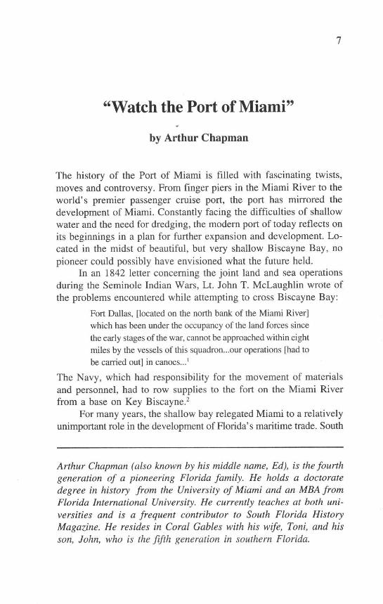
Despite Flagler's dredging efforts (this channel is still in usetoday) regular steamship service did not begin until May 21, 1897,when he obtained The City of Key West and The Miami. This serviceran only between Miami and the deep water port of Key West. Thefirst of these ships, The City of Key West, required more than 12 feetof water and was forced to anchor a mile away from Miami. Herpassengers and cargo were then tendered to shore because of theshallow depth of the bay.7
The City of Key West at the city docks, 1899. (Historical Association ofSouthern Florida, a gift of Arthur Chapman.)

Port of Miami 9
The pressing need for a deep-water port could only be solved byextensive dredging and then, as now, those operations were extremelycontroversial. For William Brickell, it was a continual source of ir-ritation. Flagler's men left a 30-foot spoil pile of broken marl andshell near Brickell's point obstructing the view of the bay from hishome on the south bank near the mouth of the river.8
Another pioneer of distinction, Commodore Ralph M. Munroe,who lived in nearby Coconut Grove, also had serious objections to thedredging operations because the spoil banks that were created re-duced the sailing area of the bay. In addition, there were many un-lighted pilings which, although necessary for the steamer pilots, be-came a constant menace to nighttime sailors. Eventually, the dredgedarea became virtually impassable, so much so, that the long estab-lished Biscayne Yacht Club was forced to abandon its race course. 9
Though modernization and big business were steadily makingtheir presence known, a certain degree of independence remained inthe hearts of some of the pioneers who worked on the bay. This spiritwas illustrated in the early 1900s by the captain of the Lady Lou, aferry that carried people between the City of Miami and Smith'sCasino on Miami Beach. He steadfastly refused to sail until he hada minimum of six passengers aboard. Once, an impatient visitor,weary of waiting, offered to pay all six fares and the captain de-murred. "No sir," he stated. "It's not the money I want. It's thepeople."'1
Henry Flagler not only played an integral role in the develop-ment of a modern Miami seaport but also an important part in the
The Miami at the city docks, 1899. (Historical Association of SouthernFlorida, a gift of Arthur Chapman.)
10 TEQUESTA
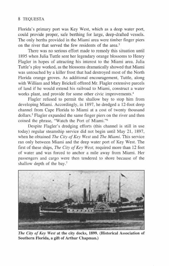
development of the maritime trade in Miami. Not only did he providefor the first dredging work, but in 1900, he merged his shippingcompany with that of Florida's west coast railroad mogul, HenryBradley Plant. This union led to the creation of the Peninsular andOccidental (P&O) Steamship Company, which built the new port onFlagler's property between 6th and 9th Streets on Biscayne Bay.Moreover, at a later date, the P&O instituted the first regular ship-ping service between Miami, Granada, and Nassau."
The P&O Steamship Company's terminal and ticket office in the late1940s at what was to become the "old port." (Historical Association ofSouthern Florida, 1989-011-13728)
As soon as the port moved to the Fifth Street area, a continuingcontroversy began which continues today. Where should the port belocated? The Flagler decision meant that some of Miami's most sce-nic and valuable bayfront property was utilized for warehouses, park-ing lots, fuel depots, and other such maritime industrial activities.Many of these uses were considered "ugly, unattractive," and "unde-sirable." Pioneers, such as Frank Walton Chapman and Stobo D'PassCurry became early activists in the effort "to get the port off ofBiscayne Boulevard." 12
The development and expansion of a port for Miami was hin-dered by a major obstacle: the Flagler Cape Florida/Miami channel
Port of Miami 11
that had been dredged in 1897 was not deep enough to allow majorvessels to call upon Miami. The distance from around Cape Floridato Miami also hindered marine development. These problems forceda search for another channel site.
In 1902, the Committee on Rivers and Harbors of the U.S.Congress appropriated money for dredging a new ship channel thatwould provide deep berths. Dredges cut a 900-foot-wide slice throughthe Miami Beach peninsula at its southern tip, thus creating Govern-ment Cut and Fisher Island. Spoil banks were also created and named,including the Dodge Islands and Lummus Island. 13 On the day thatthe dredges were to complete their project, Miami Mayor John Sewellproclaimed a holiday. About 3,500 people came to view the historicmoment. Unfortunately, the dredge broke down just as it reached thelast few feet. Reacting quickly to the crisis, "Sewell tore off his coatand necktie, picked up a shovel, and made the dirt fly." 14 In 30minutes, while the people cheered, Sewell saw the first trickle ofwater from Biscayne Bay mingle with the waters of the Atlantic. (Seecover photo.) By the next morning a free flow of water had beencreated between the ocean and the channel and the cry was, "Watchthe Port of Miami." 15
By 1926, The Voters and Taxpayers Protective League washeavily involved in the ongoing port location dispute, publishing "openletters" to all citizens and undertaking a letter writing campaign toCongress to gather support for their site plan. They had the supportof none other than Major General Harry Taylor (Chief of Engineers).Along with his support, Taylor also provided written statements onwhere he thought the port should be located. Eventually, the issuewas reduced to two possible sites: 1) "Bend of the Causeway" (today'sWatson Island) which was known as the Sewell or Waldeck Plan or:2) the "Orr Plan" which would require extensive revamping and dredg-ing of Biscayne Bay. 16
Of the two plans, the first site (Watson Island) was immediatelyavailable, required little dredging, and was somewhere from $3 to $7million cheaper than the Orr Plan. The Orr Plan called for massivedredging and the creation of a vast new island port that would extendalmost across the entire bay located on top of the Dodge Islands. Itwas this plan that resurfaced in the 1950s, leading to the creation of"The New Port of Miami" in the 1960s.' 7
The City of Miami, however, was unable to make any decisionabout either plan and in the midst of considerable controversy took no
12 TEQUESTA
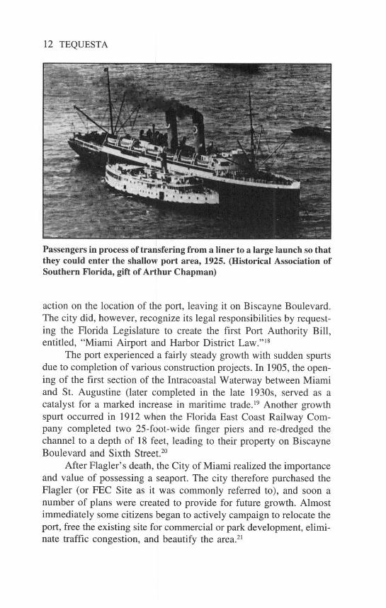
Passengers in process of transfering from a liner to a large launch so thatthey could enter the shallow port area, 1925. (Historical Association ofSouthern Florida, gift of Arthur Chapman)
action on the location of the port, leaving it on Biscayne Boulevard.The city did, however, recognize its legal responsibilities by request-ing the Florida Legislature to create the first Port Authority Bill,entitled, "Miami Airport and Harbor District Law.""18
The port experienced a fairly steady growth with sudden spurtsdue to completion of various construction projects. In 1905, the open-ing of the first section of the Intracoastal Waterway between Miamiand St. Augustine (later completed in the late 1930s, served as acatalyst for a marked increase in maritime trade. 19 Another growthspurt occurred in 1912 when the Florida East Coast Railway Com-pany completed two 25-foot-wide finger piers and re-dredged thechannel to a depth of 18 feet, leading to their property on BiscayneBoulevard and Sixth Street.20
After Flagler's death, the City of Miami realized the importanceand value of possessing a seaport. The city therefore purchased theFlagler (or FEC Site as it was commonly referred to), and soon anumber of plans were created to provide for future growth. Almostimmediately some citizens began to actively campaign to relocate theport, free the existing site for commercial or park development, elimi-nate traffic congestion, and beautify the area.21
Port of Miami 13
The 1920s witnessed an increase in the number of passengerships traveling to and from Miami. On January 1, 1921, the S.S.Georgiana Weems instituted the first regularly scheduled service be-tween Miami and Baltimore. On November 24, 1924, the S.S. Apacheentered the port, inaugurating the first direct passenger service be-tween New York and Miami. 22
During the 1920s Miami experienced "The Boom," a fantasticexplosion in the price of real estate that lured large numbers of peopleto South Florida. As land prices skyrocketed, fortunes were made ina day. A building boom accompanied the land speculation and thelumber suppliers were hard pressed to keep up with the demand. Therailroad was so swamped with incoming freight that it called for afreight embargo in August 1925 to repair overburdened tracks andprevent the train yard from being inundated with freight cars. 23 Thisaction placed the burden of delivering lumber on ocean-going freight-ers.
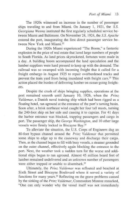
Despite the crush of ships bringing supplies, operations at theport remained smooth until January 10, 1926, when the PrinzValdemar, a Danish naval training ship which had been rigged as afloating hotel, ran aground at the entrance of the port's turning basin.Soon after, a brisk northeast wind caught her four tall masts, turningthe 240-foot ship on her side and causing it to capsize. For 41 daysthe harbor entrance was blocked, trapping passengers and cargo inport. The passenger ship, the George Washington, and 10 other largevessels were firmly locked in Biscayne Bay.24
To alleviate the situation, the U.S. Corps of Engineers dug an80-foot bypass channel around the Prinz Valdemar that permittedsome ships to edge up to the causeway and discharge their cargo.Then, as the channel began to fill with busy vessels, a steamer groundedon the outer channel, effectively again blocking the entrance to theport. Next, the weather took a sudden turn for the worse and addi-tional ships began to run aground. Almost 45 million board feet oflumber remained undelivered and an unknown number of passengerswere either trapped or unable to disembark.2 5
Ultimately, the Prinz Valdemar was refloated and beached atSixth Street and Biscayne Boulevard where it served a variety offunctions for many years.2 6 Reflecting on the grave problems causedby the sinking of the Prinz Valdemar, Commodore Munroe remarked,"One can only wonder why the vessel itself was not immediately
14 TEQUESTA
The hapless Prinz Valdemar effectively blocking the main ship channelwith dredges at work nearby. (Historical Association of Southern Florida,gift of Arthur Chapman)
blown up." It was another pioneer family, the Des Rocher Dredgingand Towing Company that finally righted the ship and set it up alongBiscayne Boulevard.2 7
The year 1926 just got worse for the port. The devastatinghurricane that struck Florida in September left the fledgling port witha collection of broken boats. The schooner Rose Mahoney was lyingon Biscayne Boulevard along with numerous other vessels, and thenew dredge that had been stationed in the bay to begin deepening thechannel was now on its bottom. But the hapless Prinz Valdemarsurvived in one piece, its only damage was having been swung out ofposition.28
The port and the maritime industry quickly recovered from thisdisaster. In 1931, the P&O Steamship Company commissioned theS.S. Florida, which became Miami's first cruise ship to make regulartrips between Cuba and Miami. 29 In 1932, the Greater Miami PortAssociation announced that the port had processed 24,168 passen-
Port of Miami 15
The 1930s dredging at the southern tip of Miami Beach with Fisher Islandto the right. (Historical Association of Southern Florida, gift of ArthurChapman)
gers, which placed Miami fourth behind New York, Boston and SanFrancisco. 30
During the 1930s, the need for a larger port and a deeper accesschannel became more more apparent to city officials. By 1932, Miami'sship channel had been dredged to a depth of 25 feet, but still not deepenough to accommodate modern ships. Thirty steamship lines thatoperated out of Boston, New York, Baltimore, Philadelphia and NewOrleans bypassed Miami. Five foreign lines expressed an interest inusing Miami as a port of call. The Port Association advocated a 35-foot channel to augment Miami's Caribbean, South American andTransatlantic shipping trade.31
Even though the dredging was not completed by the end of thefiscal year of 1937-38, the 66,458 passengers who were processedthrough the port moved Miami up in the rankings to the nation's thirdbusiest passenger port behind only New York (649,903) and Seattle(124,939). 32

16 TEQUESTA
During World War II, the U.S. Navy assumed control of theport as the area became a huge training camp for members of thearmed forces. Because U-boats were actively engaging ships just offthe coast, all cruise activity as well as coast-wide waterborne com-merce was stopped. Many of the cruise ships were converted intotroop transports (such as the President Roosevelt, today's EmeraldSeas) while many vessels were used for all types of naval tasks.33
The role of the U-boat and the danger presented to Allied ship-ping was altogether too real, especially during the early stages of thewar. On February 2, 1942, the tanker Pan Massachusetts, carrying100,000 barrels of flammable materials, was torpedoed off CapeCanaveral. 34 In May, a Mexican tanker was torpedoed, south of FoweyRock.35 One week later, another Mexican ship, the Falo de Ora, wentdown from a torpedo hit off the Florida Keys.36
Civilian craft played a significant role in the conduct of the war.Some were converted to military use while others served equallyuseful purposes. Two Miamians, Dr. F.E. Kitchens and D.R. Smithsaved 41 of the 42 men aboard the James A. Moffet, when it wastorpedoed off Tennessee Reef.3
When war hostilities ended, the Navy Department returned con-trol of the port to the City of Miami, which recognized the need fora major expansion of the facility. The planning of this expansion metwith major difficulty. The existing 26-acre site, located along Bis-cayne Boulevard, was surrounded by private developments that madeenlargement virtually impossible.38 A decade passed before any of theproposed expansion plans became a reality.
From 1946 to 1956 the port operated under authority of the Cityof Miami. It was during this period that the modern cruise industrywas born. In January 1947, the P&O Company reinstated its cruiseschedule between Miami, Havana, Nassau, and the West Indies withthe S.S. Florida.39
At the end of the 1940s, F. Leslie Fraser, a British Jamaican,envisioned the commercial possibilities of 14-day cruises in the Car-ibbean. He founded the Eastern Shipping Company and brought theNuevo Dominican to Miami to establish cruises to the DominicanRepublic. In 1951, Fraser added the Yarmouth Castle to his fleet.Three years later, he purchased the Evangeline.40 A man of vision,Fraser concentrated his marketing efforts on popularizing 10-, 12-and 14-day cruises to various Caribbean Islands. Unfortunately, theresponse to this creative idea was unenthusiastic. The Nuevo Dominica
Port of Miami 17
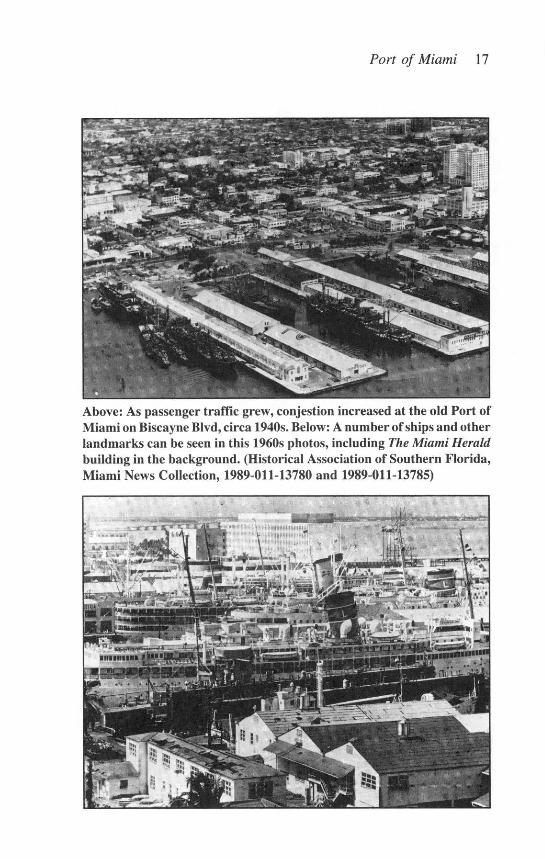
Above: As passenger traffic grew, conjestion increased at the old Port ofMiami on Biscayne Blvd, circa 1940s. Below: A number of ships and otherlandmarks can be seen in this 1960s photos, including The Miami Heraldbuilding in the background. (Historical Association of Southern Florida,Miami News Collection, 1989-011-13780 and 1989-011-13785)
4 _ '...... .T .40 i :•
ik ,
18 TEQUESTA
occasionally sailed with as few as four passengers. Fraser's otherships often sailed with fewer than 100 passengers. Known in theindustry as a man far ahead of his time, Fraser sold his interest in thefirm in the late 1950s. 41
One of the major reasons behind the decline of passenger shiptravel during the 1950s was the rising popularity of air travel. Steam-ship companies operated under the same concept of travel as theairlines did-they took people where they had to go, primarily forbusiness. The moder development of extended cruising for pleasureand relaxation was not yet a realistic venture. 42
As the 1950s came to a close, the issue of creating a larger andmore moder port came to a head. By 1956, the port plummeted inthe rankings to 35th, behind many other ports in the U.S. 43 TO haltthis decline, the City of Miami finally began preparations for a newport. Five competing proposals on where and how to construct a newport emerged: 1) expand the old port site northward by filling in thewestern shore of Biscayne Bay; 2) dredge and fill in the Dodge Is-lands; 3) build the port on Virginia Key; 4) let Port Everglades serveas Miami's seaport; or 5) build a new site on South Miami Beach.4
Since the seaport served all 27 municipalities within Dade County,the newly formed Metropolitan-Dade County Government offered toassume the responsibilities of planning and constructing the new port.Again, as in the 1920s, the location for the port became a majorissue. The Miami Herald lent its powerful voice and support byprinting entire sections on the subject. In the June 22, 1958 issue,sites were discussed. Editorially, however, The Herald supported thehistoric Orr Plan.45
Ultimately, Metro-Dade made the decision to support the OrrPlan. On July 22, 1959, Metro-Dade announced that the new portwould be constructed on a string of small islands, spoil banks, whichhad been created when the turning basin and main ship channel weredredged. This decision marked the beginning of the present DodgeIsland Seaport. (The Dodge Islands were named for Dr. R.L. Dodge,a prominent citizen and a member of the Port Authority that onceincluded both the airport and seaport.) 46
In 1960, city and county officials reached a joint agreementabout operating control of the port. Dade County purchased the ex-isting port facilities for $1.3 million and on July 1, 1960, O.W.Campbell, county manager, issued Administrative Order No. 60-5:

Port of Miami 19
Pursuant to the authority vested in me. .there is hereby cre-ated a Seaport Department that shall be responsible for theoperation of the commercial seaport and coordination of theconstruction for the new port facilities. The department shallbe organized in accordance with accompanying Chart Num-ber 41. This administrative order is effective as of the 1st dayof July 1960. This administrative order is hereby submitted tothe Board of County Commissioners. 47
Thus, the birth certificate of the New Port of Miami was drafted.For the first seven years, all the construction costs for the Dodge
Island site were paid by Dade County. This amount totaled $15.3million and was here after known as "seed money." After that, thePort of Miami was on its own, financially independent and self sup-porting. The seaport supported itself by selling revenue bonds andredeeming them from earned revenue. Each issue was given the high-est possible rating in the municipal bond market.
The "New Port of Miami" had officially opened on October 4,1964, when the JFK (a barge converted from a Navy LC-1) dis-
Cutting the ribbon for the new multi-million dollar Port of Miamiexpanision on Dodge Island, June 7,1965. From left to right, Port DirectorArthur Darlow, Commissioner Newton Green, Commissioner Joe Boyd,Dade County Vice Mayor Arthur H. Patton, Jr., and Commissioner LewWhitworth. (Historical Association of Southern Florida, 81-99-110)

20 TEQUESTA
Above: Spoil islands pre-1961, which were to become the site of the newPort of Miami and below, after construction had begun, circa 1960s.(Historical Association of Southern Florida, 81-71-1 and 81-17-2)
196 - NEW PORT
Port of Miami 21
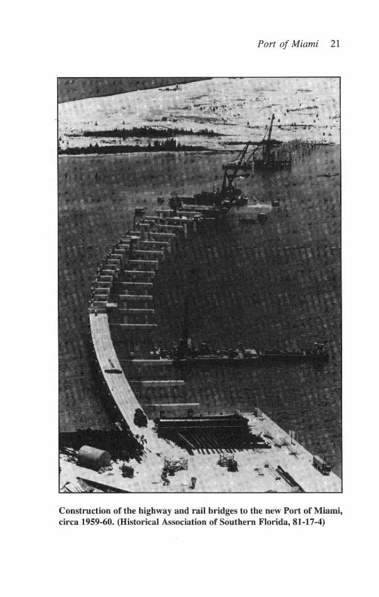
Construction of the highway and rail bridges to the new Port of Miami,circa 1959-60. (Historical Association of Southern Florida, 81-17-4)

22 TEQUESTA
charged her cargo. This barge was operated by the Miami San JuanTrailer Company, Inc. After performing in this historic event, thebarge's cargo of heavy equipment was welded to her decks as aprecaution against heavy seas. In December of the same year, how-ever, the JFK capsized and sank anyway. 48
Coordinated Caribbean Transport, Inc. (CCT) brought in theFreight Transporter on November 8, 1964. It was the first true cargovessel to berth and be worked at the new port. Another pioneeringcompany, Norwegian Caribbean Lines (NCL), had been operating theSunward, as a three-to-four-day passenger ship. On December 18,1966, the line brought her in from Marseilles, France, to Bay 26(Shed A), departing on the 19th. The Sunward was the first passengervessel to utilize the new facility. Both CCT and NCL continue to playa major role in the development of South Florida's maritime industry.By 1983, CCT was the twelfth largest cargo line and NCL was thebusiest passenger line operating at the port.49
Shed A was the first building completed at the new port. It wasa 200,000-square-foot clear span structure large enough to accommo-date three football fields end-to-end. Then two more cargo sheds,36,000 square feet each, designated as "E" and "F," were completedon the eastern end of the port for the Caribbean trade. In 1967, theCounty dedicated Shed B, a second 200,000-square-foot building. Atthe same time, the County widened the Eastern Channel to 300 feet,the South Channel to 200 feet and dredged both of them to a MeanLow Water (MLW) depth of 25 feet. During March 1973, dredgingcommenced for the deepening of the North Channel and turning basinto 36 feet MLW. This important dredging work, completed in Decem-ber 1975, provided access for larger cargo carriers.5 0
In 1965, the port placed the first of two 20,000 square footbuildings of the Maritime Office Center in use. Fifteen years later,they completed an additional five-story, 36,000-square-foot officebuilding that interconnected with the original two.
By 1967, the New Port of Miami assumed all the functions ofthe old port. (Later, the old site became Bicentennial Park.) On De-cember 29, 1968, the $5 million first five passenger terminals wereformally dedicated. Port Director Irwin Stephens, a retired admiral,proceeded with the ceremony even though the InternationalLongshoremen's Union was on strike. At the time of the dedication,the terminal was only two-fifths complete. The total plan called forfive separate "piers," each capable of handling about 2,500 passen-
Port of Miami 23
gers.51 Within a year of its opening, only the Port of New York couldclaim more cruise passengers.52
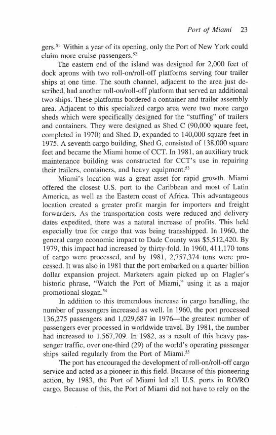
The eastern end of the island was designed for 2,000 feet ofdock aprons with two roll-on/roll-off platforms serving four trailerships at one time. The south channel, adjacent to the area just de-scribed, had another roll-on/roll-off platform that served an additionaltwo ships. These platforms bordered a container and trailer assemblyarea. Adjacent to this specialized cargo area were two more cargosheds which were specifically designed for the "stuffing" of trailersand containers. They were designed as Shed C (90,000 square feet,completed in 1970) and Shed D, expanded to 140,000 square feet in1975. A seventh cargo building, Shed G, consisted of 138,000 squarefeet and became the Miami home of CCT. In 1981, an auxiliary truckmaintenance building was constructed for CCT's use in repairingtheir trailers, containers, and heavy equipment. 53
Miami's location was a great asset for rapid growth. Miamioffered the closest U.S. port to the Caribbean and most of LatinAmerica, as well as the Eastern coast of Africa. This advantageouslocation created a greater profit margin for importers and freightforwarders. As the transportation costs were reduced and deliverydates expedited, there was a natural increase of profits. This heldespecially true for cargo that was being transshipped. In 1960, thegeneral cargo economic impact to Dade County was $5,512,420. By1979, this impact had increased by thirty-fold. In 1960, 411,170 tonsof cargo were processed, and by 1981, 2,757,374 tons were pro-cessed. It was also in 1981 that the port embarked on a quarter billiondollar expansion project. Marketers again picked up on Flagler'shistoric phrase, "Watch the Port of Miami," using it as a majorpromotional slogan.54
In addition to this tremendous increase in cargo handling, thenumber of passengers increased as well. In 1960, the port processed136,275 passengers and 1,029,687 in 1976-the greatest number ofpassengers ever processed in worldwide travel. By 1981, the numberhad increased to 1,567,709. In 1982, as a result of this heavy pas-senger traffic, over one-third (29) of the world's operating passengerships sailed regularly from the Port of Miami.55
The port has encouraged the development of roll-on/roll-off cargoservice and acted as a pioneer in this field. Because of this pioneeringaction, by 1983, the Port of Miami led all U.S. ports in RO/ROcargo. Because of this, the Port of Miami did not have to rely on the
24 TEQUESTA
Florida economy for success, as much of the processed cargo origi-nated elsewhere. This was especially true for transshipped containers.By 1983, 36 modem trailer ships (they also carry containers) calledMiami home.56
Just as the operating philosophy of the port has pioneered newpassenger and cargo methods, it has also encouraged the developmentof academic and scientific centers. In 1967, the Environmental Sci-ence Services Administration, now the National Oceanic and Atmo-spheric Administration (NOAA), selected the Port of Miami from 114competing areas as its base of operations for oceanographic researchvessels. The first NOAA vessel was the $10 million M/V Discoverer.A four-building shoreside and maintenance base and an 800-foot longslip for the research ships was constructed for NOAA near the centerof the south half of the port. The University of Miami's RosenstielInstitute of Marine Sciences shares the use of the slip and some of theother facilities. 57
The original 25-Year Master Plan (1969) for the developmentand expansion of the port called for 17,000 linear feet of peripheralberthing. However, the rapid growth rate of the port was not antici-pated. The 1979 expansion program called for the creation of anadditional 295 acres of land and two towering container cranes (40long tons each). In March 1983, both cranes were fully operationaland the tagline of the port was modified to add "The Container Portof the South" to "The Cruise Capital of the World," a designationattained 10 years earlier.58
One of the main catalysts for the port's growth was the 1966decision by Norwegian Caribbean Lines to use the port as its base ofoperations. When NCL established its operations there, the total numberof passengers was down because of adverse publicity from two cruiseship fires. The presence and marketing effort of NCL, which intro-duced cruises that had immediate public appeal, is credited with stop-ping the decline.59
In 1966, NCL introduced the highly successful M.S. Sunwardwith one class cruising on three- and four-day cruises. In 1968, theyintroduced the M.S. Starward, the first ship to offer year-round seven-day cruises to Jamaica. Then in 1970, the M.S. Skyward became thefirst ship to make regular stops at Cap Haitian, Haiti, which subse-quently became a popular cruise port. In 1972, NCL offered a 14-daycruise, the first since the 1950s. By 1975, NCL was the only com-

Port of Miami 25
pany offering three Caribbean itineraries. In May 23, 1980, N.C.L.brought in the S.S. Norway (formerly The France), the largest pas-senger ship in the world.60
The port's growth exploded beyond expectations. The 1961master plan had projected 850,000 passengers by 1985, a figuresurpassed 12 years ahead of time in 1973. 61
The year 1973 was to become the port's new benchmark ofsuccess, attaining the nation's cruise capital status, based on thenumber of cruise ships that provided regular service from the facility.Three years later, the port was regarded as the cruise capital of theworld, processing more than one million passengers annually. By1979, one-third of the world's cruise liners worked out of the port andthe annual passenger total climbed to more than 1.3 million. 62
The appointment of Carmen J. Lunetta as port director in 1979marked the beginning of a new era. Under his aggressive leadership,the level of port activities expanded as never before. 63 The Twenty-Five Year Master Plan, then just 10 years old, had to be completelyrewritten. Expansion moved so quickly that it was necessary for theconsulting firm of Post, Buckley, Schuh, and Jurnigan, Inc. to main-tain an office at the port. Mr. Blaise Lionelli, project manager forPost Buckley, soon became as well known as anyone on the Director'sstaff. Because of the port's exciting development, expansion and growthbecame everyday topics.6
Today, the main ship's channel is 40 feet deep and can accom-modate the world's largest passenger ships. Office space at the porthas tripled to more than 100,000 square feet. Moreover, six moretransit sheds have been completed, berthing increased by 40 percent,and a total of 20,800 feet of railway track was added. The sailors'recreational needs were also addressed with a tennis court, track,soccer field, gym, and an Olympic-size swimming pool.65
Though the past has been bright, the future looks even brighter.The master plan at the time of this writing looks to fully developingLummus and Sams Islands which are adjacent to the present facility,thus doubling the present cruise and cargo facilities. This plan hasfour distinct phases and the estimated cost for the entire project is$230.3 million. The completion date has been set for the year 2000,but if past performance holds true, it may occur much earlier.66
Certainly the records indicate that such rapid advancement ispossible. Consider the following chart:

26 TEQUESTA
Year Revenue Passengers Cargo67
1981 10,339,907 1,567,709 2,757,3741982 11,867,619 1,760,255 2,665,9211983 14,201,008 2,002,654 2,305,6451984 15,943,548 2,217,065 2,287,2811985 17,135,048 2,326,685 2,333,0261986 18,223,415 2,520,571 2,405,7841987 19,933,197 2,633,041 2,425,9371988 26,489,275 2,502,411 2,602,5561989 30,035,859 3,100,055 3,206,4171990 32,236,465 2,734,816 3,590,9371991 36,033,262 2,928,532 3,882,284
The economic importance of this very rapid growth is not lim-ited to maritime operations alone. It includes related enterprises suchas hotels, restaurants, trucking and handling of food, related travel,etc. This economic ripple effect was pegged in 1981 at a value of$1.76 billion. In 1986 the figure was $3.1 billion and in 1991 thefigure increased to $5.27 billion. 68
Today, the growth and development of the port remains unprec-edented. Restricted from further eastward expansion due to the FisherIsland development the port has turned its sites back to its beginnings,back to Flagler's Biscayne Boulevard site. In any case, one statementis worth remembering today: "Watch the Port of Miami."
Port of Miami 27
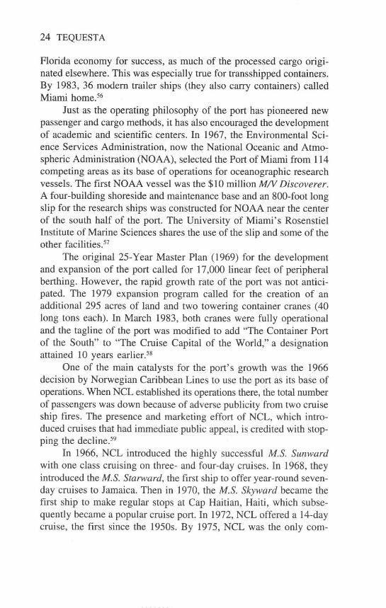
The growth of the Port of Miami from the days of rail to the number oneranking by passenger count in the world is typified by this photo of thesailing ship, Christian Radich and the ultra-modern Song of Norway.(Historical Association of Southern Florida, gift of Arthur Chapman)
Endnotes
1. Letter from J.T. McLaughlin to A.P. Upshur, January 16,1842. Naval Records, Information Relating to the Service of theNavy and Marine Corps, p. 109. See also National Archives, EarlyWars Branch, Adjutant General's Office, Orders and Special Orders,Volume 10, 1837-1838 and "Notes on Fort Dallas," Records Group94, Document File No. 44540.
2. Ibid.3. Unpublished notes found in the Port of Miami File located at
the library of the Historical Association of Southern Florida (HASF).Hereafter referred to as "PHF."
4. Ibid; See also Helen Muir, Miami, U.S.A. (New York: Holt& Co., 1953), 69.

28 TEQUESTA
5. Ibid; See also James E. Buchanan, ed., Miami: A Chrono-logical And Documantary History (New York: Oceana Publish-ing,1978), 4-5.
6. Ibid. In 1981, the Port of Miami embarked on a quarter-billion-dollar expansion program using this quote and developing itinto a marketing/promotional slogan.
7. Ibid.8. Ibid.9. Ibid; See also John Sewell, Memoirs and History of Miami,
Florida (Miami: The Franklin Press, 1933), 14.10. Interview with Estelle Chapman Fay, Lamar Louise Curry
and Lenore McLean. Notes are in the possession of the author. Hereafter referred to as "Interviews."
11. PHF.12. Interviews.13. PHF, South Florida Maritime History folder in file, 2.14. Ibid. Sewell is honored with a historical marker located in
Seaman's Park at the port.15. Ibid.16. PHF, Greater Miami Port Plan.17. Ibid.18. Ibid.19. Ibid.20. Ibid; See also Florida State Planning Board, Miami and
Dade County (New York: Bacon, Perry & Daggett, 1940), 3.21. PHF.22. Florida State Planning Board.23. Ibid.24. Ibid.25. Ibid; See also Samuel J. Boldrick, "The Ship That Stopped
The Boom," Update (June 1975), 8-9.26. Kenneth Ballinger, Miami's Millions (Miami: Franklin Press,
1936), 119.27. Interviews.28. PHF; See also Boldrick.29. Ibid.30. PHF; Greater Miami Port Association, Port of Greater Miami
(Miami: Greater Miami Port Association, 1932), 1.31. Ibid, 7-8, 20.32. Miami's Chamber of Commerce, "Relative Standings, Port

Port of Miami 29
of Miami Fiscal Year, 1937-1938." See also PHF.33. I. J. Stephens, "The Port of Miami," Update (June, 1975),
3. See also the "Petition for Amplification of Greater Miami PortProject" (Document 470, 76C, 1st S), (Miami: City of Miami). Thesedocuments detail the military importance of the port as well as itsimportance in terms of international trade.
34. James E. Buchanan, ed. Miami: A Chronological And Docu-mentary History (New York: Oceana Publishing, 1978), 35.
35. Ibid., 36.36. PHF37. Ibid.38. Stephens, 3-12.39. PHF40. Ibid.41. Ibid. Fraser was a true maritime pioneer who helped to
create the modem cruise industry.42. Hugh B. Cave, Wings Across The World: The Story of the
Air Transport Command (New York: Dodd Mead and Company,1945), 163-174.
43. PHF; "Decrepit Port is City's Now," Miami News, October18, 1956; "Neglected City Docks Have Turned Away Ships for Lackof Space and Facilities," The Miami Herald, December 16, 1956;"Miami Neglects Marine Port, Boots Its Port Plan Again," MiamiNews, February 6, 1957; "Ocean Port Neglected, It Rates 35th inU.S.," The Miami Herald, December 16, 1956, 6G.
44. Stephen Trumbull, "Port Plans Bring Hot Arguments," TheMiami Herald, September 22, 1956; "What is the Proper Role ofMiami's City Docks?" The Miami Herald, September 22, 1956; "KeySite Again Eyed For Port," The Miami Herald, February 6, 1957.
45. Juanita Greene, "New Port Waits at Crossroads," The Mi-ami Herald, April 26, 1956; "What's To Do About Miami Port, TheMiami Herald, October 14, 1956; "City Faces Challenge on Sea-port," The Miami Herald, April 19, 1959; Paul Einstein, "Port BattlesSlug In Open," The Miami Herald, May 8, 1959.
46. Ibid.47. Metropolitan Dade County, Administrative Order 60-5.48. PHF, Port Handbook.49. Ibid.50. Ibid.51. PHF, Greater Miami Port Plan and Port of Miami History, 2.

30 TEQUESTA
52. PHF, Port of Miami Fact Sheet, 1980, 3-9; JoAnn Werner,"Port of Miami Opens $5 Million Terminal," The Miami Herald,December 30, 1968.
53. PHF.54. Ibid.55. Ibid.56. Ibid, Norwegian Caribbean Lines, travel brochures and travel
agenda for the M.S. Starward and history of NCL, 1-6.57. PHF.58. Ibid.59. Ibid.60. Ibid.61. PHF, Port Fact Sheet 1980, 9.62. Ibid.63. M.R. Stierheim, "Appointment of Seaport Director Memo,"
January 16, 1979. Carmen J. Lunetta replaced Captain Robert Waldronwho retired in 1978. The other directors were Admiral Irving J. Stephens,Arthur Darlow and Charles A. Olsen.
64. PHF, Port Fact Sheet 1980, 4.65. Ibid, Port Fact Sheet 1980, 4-5; See also Annual Reports.66. Ibid.67. Ibid.68. Ibid.