water management plan - austar coal mine > · pdf file · 2017-06-07landform and...
TRANSCRIPT

WATER MANAGEMENT PLAN
LWB1-B3 Extraction Plan
FINAL July 2016

Water Management Plan 3542_R13_Water Management Plan_V4
Table of Contents 1.0 Introduction 2
1.1 Background 2 1.2 Purpose and Scope 2 1.3 Environmental Context 2
1.4 Plan Structure 5
2.0 Performance Objectives 6
2.1 Licences 6 2.2 Performance Objectives 7
3.0 Description of Environmental Values 10
3.1 Land Use and Topography 10 3.2 Geology and Soils 10 3.3 Water Resources 11
3.3.1 Surface Water 11 3.3.2 Groundwater 11
4.0 Predicted Impacts to Water Resources 13
5.0 Monitoring 19
5.1 Surface Water Monitoring 19 5.2 Groundwater Monitoring 19 5.3 Riparian and Groundwater Dependent Ecosystem Monitoring 21 5.4 Subsidence Monitoring 21
5.5 Summary 21
6.0 Trigger Action Response Plan 23
7.0 Roles and Responsibilities 27
8.0 Reporting 28
8.1 Incident Reporting 28
8.2 Annual and Regular Reporting 28
9.0 References 29

Water Management Plan 3542_R13_Water Management Plan_V4
Figures Figure 1.1 Figure 1.2 Figure 4.1 Figure 4.2 Figure 4.3 Figure 4.4 Figure 5.1
LWB1-B3 Extraction Plan Area 3 Catchment Context 4 Maximum Flood Depths for 1% AEP Storm Event Comparison of Current Landform and LWB1-B3 Modifications (As approved) with Approved Stage 3 Mining 15 Remnant Ponding with LWB1-B2 Modification (As approved) and Approved Stage 3 Mining 16 Maximum Flood Hazard Categories for 1% AEP Storm Event Comparison of Current Landform and LWB1-B3 Modifications (As approved) with Approved Stage 3 Mining 17 Estimated Extent of Alluvium and Groundwater Monitoring and Bore Locations 18 Existing and Proposed Surface Water and Groundwater Monitoring Locations 20
Tables Table 2.1 Table 3.1 Table 4.1 Table 5.1 Table 7.1
Licence Summary 7 Summary of Existing Groundwater Monitoring Data (Dundon 2015) 12 Summary of Potential Impacts to Water Resources of Mining LWB1-B3 13 Existing and Proposed Monitoring Program for the LWB1-B3 Extraction Plan Area 21 Roles and Responsibilities 27

Water Management Plan 3542_R13_Water Management Plan_V4
Introduction 2
1.0 Introduction
1.1 Background
Austar Coal Mine Pty Ltd (Austar), a subsidiary of Yancoal Australia Limited (Yancoal) owns the Austar Coal Mine, an underground coal mine located approximately 10 kilometres south of Cessnock in the Lower Hunter Valley in NSW (refer to Figure 1.1). The Austar Coal Mine incorporates the former Ellalong, Southland and Bellbird South Collieries and includes coal extraction, handling, processing and rail and road transport facilities.
Extensive longwall mining has been undertaken within the Austar Coal Mine in accordance with a number of approvals. The mining of three longwall panels, LWB1-B3, was approved by the Minister for Planning under DA 29/95 MOD 6 on 29 January 2016.
During 2016, Austar gained further information on the location and nature of geological structures in the area of Longwall B2 and Longwall B3. This resulted in a necessary refinement of the mine plan to shorten those panels at the commencing and finishing ends in response to those structures. Austar was approved by the nominee for the Secretary of the Department of Planning and Environment on 29 April 2016 to shorten Longwall B2 and Longwall B3, and the extent of those shortened panels has been used in all diagrams and subsidence predictions in the preparation of the Extraction Plan.
1.2 Purpose and Scope
The purpose of this Water Management Plan (WMP) is to detail the management strategies, controls and monitoring programs to be implemented for the management of potential impacts to surface water and groundwater arising from the extraction of Longwalls (LW) B1-B3 (refer to Figure 1.1). This WMP applies to the LWB1-B3 Extraction Plan Area (the Extraction Plan Area) shown on Figure 1.1, this being the land within the predicted 20 millimetre subsidence contour for LWB1-B3. This WMP is a requirement of the conditions of development consent for extraction from Longwalls B1-B3.
1.3 Environmental Context
The Extraction Plan Area is located within the Quorrobolong Creek catchment area (refer to Figure 1.2). Quorrobolong Creek drains in a northerly direction along the north-east boundary of Extraction Plan Area. An unnamed tributary of Quorrobolong Creek that includes a number of secondary drainage channels drains in a northerly direction through the Extraction Plan Area. The Extraction Plan Area is located largely beneath cleared private land used for agricultural and rural-residential purposes and there are several dwellings within the Extraction Plan Area. One private stock bore and two groundwater monitoring bores are located within the Extraction Plan Area. The Extraction Plan Area underlies Sandy Creek Road and a small section of Barbara Lane. The topography of the land is generally characterised by low undulating hills and creek flats, with no steep slopes or cliffs. Refer to Section 3.0 for further details regarding the catchment context.
Figure 1.2 shows the watercourses and catchment boundaries within the LWB1-B3 Extraction Plan Area.


Water Management Plan 3542_R13_Water Management Plan_V4
Introduction 5
1.4 Plan Structure
The WMP is structured as follows:
• Section 1 provides an introduction to the WMP.
• Section 2 describes the water related performance objectives relevant to the WMP.
• Section 3 describes the existing environmental values within the Extraction Plan Area as they relate to surface water and groundwater.
• Section 4 summarises the predicted impacts and environmental consequences associated with extraction from LWB1-B3 for surface water and groundwater.
• Section 5 describes the surface and groundwater monitoring measures that will be implemented within the Extraction Plan Area.
• Section 6 provides a Trigger Action Response Plan (TARP) to manage unpredicted impacts and their consequences.
• Section 7 outlines the roles and responsibilities for the WMP.
• Section 8 outlines the reporting requirements of the WMP.
In accordance with Condition 3A of Schedule 3 of DA29/95, this WMP has been prepared by Susan Shield of Umwelt (Australia) Pty Limited, and reviewed by Peter Dundon of Dundon Consulting Pty Ltd. Both are suitably qualified and experienced experts whose appointment was endorsed by the Secretary of the Department of Planning and Environment. The WMP has been prepared in consultation with the Office of Environment and Heritage (OEH) and Department of Primary Industries Water (DPI-Water).

Water Management Plan 3542_R13_Water Management Plan_V4
Performance Objectives 6
2.0 Performance Objectives This WMP has been prepared to specifically address Condition 3A (e) of Schedule 3 of DA 29/95, as modified, which states:
3A. The Applicant shall prepare and implement an Extraction Plan for all second workings in the Longwalls B1-B3 mining area to the satisfaction of the Secretary. This plan must:
(e) include a:
• Water Management Plan, which has been prepared in consultation with OEH and DPI-Water, to manage the environmental consequences of second workings on water resources (including flooding, ponding and alluvial aquifers).
Note: The Water Management Plan must be integrated with all relevant aspects of the Site Water Management Plan required under condition 6 of Schedule 3.
In addition, the WMP has been prepared to address Condition 28 item 2 of Schedule 3 of DA 29/95:
28. The Applicant shall achieve the rehabilitation objectives in Table 6 to the satisfaction of DRE.
Table 6: Rehabilitation Objectives (partially reproduced): Domain Rehabilitation objective Land affected by the development (including watercourses and steep slopes)
Rehabilitate the site so that landuse and ecosystem function is the same as pre-mining and consistent with the surrounding landform. Reduce safety hazards to no more than those existing pre-mining. Minimise erosion risk.
2.1 Licences
The Extraction Plan Area is located within the Congewai Creek Management Zone of the Upper Wollombi Brook Water Source within the Hunter Unregulated and Alluvial Water Sources Water Sharing Plan (WSP) area. The WSP regulates maximum water extractions and allocations from surface flows and alluvial aquifers. By complying with the requirements of the WSP, water take will be within the sustainable yield for the water system as determined by the NSW Government. This in turn provides for sustainable environmental flows within the water systems.
Porous rock groundwater sources are regulated under the WSP for the North Coast Fractured and Porous Rock Groundwater Sources (which commenced on 1 July 2016).
The alluvial aquifer associated with Quorrobolong Creek and its tributaries within the LWB1-B3 Extraction Plan Area is not characterised as a ‘highly productive’ groundwater source or a highly connected surface water source, as defined by the NSW Aquifer Interference Policy as they do not meet the relevant water quality and yield requirements for ‘highly productive’ groundwater sources. The lack of registered bores within the area also indicates that the alluvial aquifer in the vicinity of the LWB1-B3 Extraction Plan Area

Water Management Plan 3542_R13_Water Management Plan_V4
Performance Objectives 7
has limited use as a water supply for stock, domestic or other consumptive purpose. An assessment against the NSW Aquifer Interference Policy minimal impact considerations for less productive groundwater sources was undertaken as part of the LWB1-B3 Modification Environmental Assessment (Umwelt 2015) and found that:
• The Project will not impact any high priority groundwater dependent ecosystem or high priority culturally significant site listed in a WSP.
• The potential impact of the Project on any water supply work is considered negligible.
• There are no highly connected surface water sources or water sources that represent a ‘reliable water supply’ within proximity to the Project.
• The Project is not expected to further limit potential beneficial uses of the alluvial or porous rock groundwater supply.
On this basis, it is considered that the LWB1-B3 Modification adequately satisfies the minimal impact considerations for less productive groundwater sources defined by the NSW Aquifer Interference Policy
Austar Coal Mine holds Water Access Licence 19181 with 10 shares in the Upper Wollombi Brook Water Source - Congewai Creek Management Zone. Should impacts from subsidence cause passive take of surface or alluvial water this must be accounted for via an appropriate access licence, such as WAL 19181. The low potential for impacts to surface water or alluvial water is described in Table 4.1. Notwithstanding there is sufficient unit shares available within this water source should additional licences be required. Austar Coal Mine’s current water take from the porous rock groundwater source is authorised under access licences 20BL171481, 20BL173349 and 20BL173350, which have a combined licence entitlement of 770ML/year. Table 2.1 shows Austar Coal Mine’s estimated take, with the LWB1-B3 Modification, as defined by the LWB1-B3 Modification Environmental Assessment (Umwelt 2015). Notwithstanding there is sufficient unit shares available within this water source should additional licences be required.
Table 2.1 Licence Summary
WSP Water Source Predicted Take Licences Held
Hunter Unregulated and Alluvial Water Sources
Upper Wollombi Water Source - Congewai Creek Management Zone
0 10 shares
Water Act 1912 – to be replaced by:
(Draft) North Coast Fractured and Porous Rock Groundwater Sources
Sydney Basin – North Coast Groundwater Source
550 ML 770 ML
2.2 Performance Objectives
Performance objectives in relation to impacts on water resources within the LWB1-B3 Extraction Plan Area are defined by the conditions of consent of DA29/95 and relevant commitments of the LWB1-B3 Modification Environmental Assessment. These performance objectives are presented in Table 2.2.

Water Management Plan 3542_R13_Water Management Plan_V4
Performance Objectives 8
Table 2.2 Performance Objectives
Requirement Performance Measure Performance Indicator
DA29/95 Sch3 condition 3
Implementation of a WMP and integration of plan with all relevant aspects of the Site Water Management Plan
WMP includes actions to manage potential environmental consequences of second workings on water resources
WMP is prepared in consultation with OEH and DPI-Water
WMP is integrated with all relevant aspects of the Austar Site Water Management Plan
Plan is approved by Secretary of the Department of Planning and Environment
DA29/95 Sch3 condition 28
If required, rehabilitation works will result in landuse and ecosystem function that is the same as pre-mining and consistent with the surrounding landform
Rehabilitation management strategies consider pre-mining landuse and surrounding landform (addressed in Extraction Plan Land Management Plan and Biodiversity Management Plan)
Safety hazards are no more than those existing pre-mining
Monitoring indicates no significant difference between predicted and observed subsidence (addressed in Extraction Plan Public Safety Management Plan)
Erosion risk is minimised Monitoring indicates that the erosive risk to creeklines within the Extraction Plan Area is consistent with the pre-mining erosive risks following mining and any required rehabilitation activities
Monitoring indicates no significant impact to channel stability as a result of mining and any required rehabilitation activities
EA – Management Measures 7.2.2
Subsidence impacts on drainage lines are effectively remediated such that there is no significant adverse impact on downstream water users and environmental flows
Monitoring indicates no significant adverse impact to bore supply or yield at privately owned bore
Monitoring indicates no significant adverse impact to the volume of privately owned farm dams

Water Management Plan 3542_R13_Water Management Plan_V4
Performance Objectives 9
Requirement Performance Measure Performance Indicator
Monitoring of groundwater levels within the unnamed tributary of Quorrobolong Creek indicates no significant adverse impact on groundwater levels or quality as a result of mining

Water Management Plan 3542_R13_Water Management Plan_V4
Description of Environmental Values 10
3.0 Description of Environmental Values
3.1 Land Use and Topography
The LWB1-B3 Extraction Plan Area is located in Quorrobolong; approximately three kilometres east of the township of Ellalong in the lower Hunter Valley of NSW. The Extraction Plan Area is located largely within cleared private land used for agricultural and rural-residential purposes.
Land use surrounding the Extraction Plan Area is primarily rural to the north, east and south, with vegetated parcels of Crown and Austar owned land to the west. The dominant land use within and surrounding the area is grazing, however also includes rural residential, vegetated land and underground mining and coal processing associated with the Austar Coal Mine. The villages of Kitchener, Abernethy, Ellalong, and Paxton are located within 4 kilometres north and west of the Extraction Plan Area (refer to Figure 1.1). The Watagans National Park is located approximately 4 kilometres south of the Extraction Plan Area and the Werakata State Conservation Area is located approximately two kilometres to the north.
The Extraction Plan Area is located predominantly to the south of Sandy Creek Road, with the northern end of the proposed longwalls extending beneath Sandy Creek Road and Barraba Lane, both of which are local Council roads.
The topography of the Extraction Plan Area is generally characterised by low undulating hills and creek flats associated with an unnamed tributary of Quorrobolong Creek. Elevations within the Extraction Plan Area range from approximately 130 mAHD to 150 mAHD.
3.2 Geology and Soils
One soil landscape type is found within the Extraction Plan Area, being the Quorrobolong soil landscape (Kovac and Lawrie 1991). The main soils within this landscape are prairie soils which form in alluvium and occur in drainage depressions and on lower slopes. They are generally poorly drained, have moderate permeability and the upper horizon has moderate erodability (Kovac and Lawrie 1991). The soils are moderately fertile and the main land use is generally grazing on unimproved pasture.
The Austar Coal Mine is located in the Newcastle Coalfield and targets coal extraction from the Greta Coal Seam within the Permian Age Greta Coal Measures. The depth of cover directly above the proposed longwalls ranges from approximately 480 metres at the western edge of LWB3 to approximately 555 metres in the north-eastern corner of LWB1. The Greta Seam is the main economic coal seam in the Greta Coal Measures. The Greta Coal Measures are overlain by the Branxton Formation, which is comprised of a substantial thickness of sedimentary rocks and is up to 1300 metres thick in some locations (Geoscience Australia, 1988).

Water Management Plan 3542_R13_Water Management Plan_V4
Description of Environmental Values 11
3.3 Water Resources
3.3.1 Surface Water
The Extraction Plan Area is situated within the Quorrobolong Creek Catchment, a sub-catchment to the larger Wollombi Brook catchment and ultimately the Hunter River catchment. Quorrobolong Creek forms part of the Congewai Creek Management Zone of the Upper Wollombi Water Source within the Hunter Unregulated and Alluvial Water Sources Water Sharing Plan area. Quorrobolong Creek is located to the east and north of the Extraction Plan Area (refer to Figure 1.1) and flows north from the Myall Range then west into Ellalong Lagoon. An un-named tributary of Quorrobolong Creek runs from south to north across the Extraction Plan Area, joining Quorrobolong Creek approximately 600 metres to the north-west (refer to Figure 1.1). Both Quorrobolong Creek and its unnamed tributary are ephemeral creeks with flows only occurring as a result of prolonged or high rainfall periods. Quorrobolong Creek has an average gradient of less than 1 mm/m while the unnamed tributary has an average gradient of 5 mm/m.
Monitoring has not detected any scouring or erosion issues observed within or surrounding watercourses associated with previous Stage 2 and Stage 3 mining.
3.3.2 Groundwater
The main sources of water that make up the groundwater regime within the Austar Coal Mine and surrounding area are:
• the localised alluvial aquifer system associated with the Quorrobolong Creek and its tributaries
• non-alluvial hard rock aquifers comprising principally of the coal seams and to a lesser extent, fractured zones within the upper parts of the Branxton Formation
• water stored within previous underground mine voids.
Groundwater within the alluvial aquifer in the Extraction Plan Area is part of the Congewai Creek Management Zone of the Upper Wollombi Brook Water Source and is regulated by the Water Management Act 2000 under the Water Sharing Plan for the Hunter Unregulated and Alluvial Water Sources 2009. The non-alluvial groundwater is regulated under the Water Act 1912.
Previous monitoring within the Stage 2 and Stage 3 areas beneath private land holdings, Quorrobolong Creek and the tributaries of Quorrobolong Creek has not identified any adverse impacts on groundwater as a result of underground longwall mining.
The existing groundwater monitoring network is shown on Figure 3.1. A summary of baseline groundwater monitoring data collected from the existing groundwater monitoring network within the vicinity of the Extraction Plan Area is provided in Table 3.1.

Water Management Plan 3542_R13_Water Management Plan_V4
Description of Environmental Values 12
Table 3.1 Summary of Existing Groundwater Monitoring Data (Dundon 2015)
Bore ID Data Collection Period
Summary of Levels
Summary of Quality
Comments
GW080974 2010 - 2014 0.5-2.3 mbgl Conductivity 33-2,632 µS/cm
Variable level and quality
AQD1073 Jul 2010 – Mar 2015 (quality)
Aug 2011 – Sep 2007 (levels)
0-4.7 mbgl Conductivity 75-2,632 µS/cm
pH 6-10.5
Variable level and quality
WBH1 Jul 2010 – Mar 2015 (quality)
Aug 2011 – Mar 2015 (levels)
5.7-11.7 mbgl Conductivity 63-1,188 µS/cm
pH 6.2-9.0
Variable level and quality
WBH2 Jul 2010 – Mar 2015 (quality)
Aug 2011 – Mar 2015 (levels)
0.8-6.8 mbgl Conductivity 282-1,128 µS/cm
pH 6.5-8.8
Variable level and quality
WBH3 Jul 2010 – Mar 2015 (quality)
Aug 2011 – Mar 2015 (levels)
0.4-6.7 mbgl Conductivity 33-935 µS/cm
pH 6.6-8.8
Variable level and quality
Note – Both water level and water quality in all bores varies in response to episodic rainfall recharge.

Water Management Plan 3542_R13_Water Management Plan_V4
Predicted Impacts to Water Resources 13
4.0 Predicted Impacts to Water Resources Potential changes in the ground surface resulting from subsidence associated with the approved extraction have been assessed by Mine Subsidence Engineering Consultants (MSEC 2015). The subsidence assessment findings conclude that due to the depth of mining (greater than 480 metres), the small magnitude of predicted ground curvatures and strains and the absence of any steep slopes or cliffs within the Extraction Plan Area, the potential for surface cracking is low.
The height of discontinuous fracturing above the longwall panels is predicted to be in the order of 235 metres to 355 metres above the seam. Given the minimum depth of cover within the Extraction Plan Area of 480 metres, extension of the fracture zone to the surface was not predicted in the LWB1-B3 Modification Environmental Assessment (Umwelt 2015).
A summary of the potential subsidence impacts and their likely environmental consequences on hydrological features within the Extraction Plan Area as stated in the LWB1-B3 Modification Environmental Assessment (Umwelt 2015) is provided in Table 4.1 below.
Table 4.1 Summary of Potential Impacts to Water Resources of Mining LWB1-B3
Potential Subsidence Impact
Environmental Consequence Likelihood of Environmental Consequence
Surface cracking Erosion causes impacts to surface water quality from cracks
Unlikely
Subsidence crack remediation causes surface water quality impact
Unlikely
Loss of surface flows to the subsurface Unlikely
Loss of water from dams due to cracking Unlikely
Impacts to near surface groundwater within alluvium and shallow water-bearing zones
Unlikely
Surface cracking increases connectivity between alluvium and underlying bedrock, causing groundwater to drain into bedrock
Unlikely
Landform changes by tilts and/or localised buckling of strata
Changes to hydraulic regime of Quorrobolong Creek and its unnamed tributary
Unlikely
Erosion causes impacts to surface water quality
Unlikely
Changes to flood response within Extraction Plan Area
Minor temporary changes to velocity and out of channel flooding likely (refer to Figure 4.1)

Water Management Plan 3542_R13_Water Management Plan_V4
Predicted Impacts to Water Resources 14
Potential Subsidence Impact
Environmental Consequence Likelihood of Environmental Consequence
Increase of surface water ponding, Some minor increases likely (refer to Figure 4.2)
Increased scour/erosion in channel Unlikely
Flood hazard increased at dwellings and access roads
Not predicted to occur (refer to Figure 4.3)
Change in freeboard and storage capacity of farm dams
Very minor changes likely
Impacts to groundwater levels within the alluvial aquifer or shallow water bearing zones of porous rock aquifer
Minor changes likely where subsidence troughs coincide with shallow alluvium
Adverse impact on groundwater quality within alluvium or shallow water-bearing zones
Unlikely
Adverse impact on groundwater quality or yield affecting other users
Unlikely
Adverse impact on groundwater extraction infrastructure, including the one private stock bore within the Extraction Plan Area (refer to Figure 4.4)
Possible
Increase in mine water inflows Minor and temporary increase likely
Adverse impact on groundwater levels in near-surface aquifer system adversely impacting groundwater dependent ecosystems
Unlikely
Loss of near surface groundwater due to fracturing extending to the surface
Unlikely
Secondary impacts to hydrological values
Loss of vegetation due to dieback Unlikely
Impacts to groundwater dependent ecosystems
Unlikely


Water Management Plan 3542_R13_Water Management Plan_V4
Monitoring 19
5.0 Monitoring Austar currently implements a range of surface water and groundwater management and monitoring measures across the Austar Coal Mine, as outlined in the Austar Site Water Management Plan (SWMP) (Austar 2013). Results of monitoring are reviewed annually and reported in the Annual Review.
5.1 Surface Water Monitoring Water quality samples are taken monthly within Quorrobolong Creek in accordance with the Austar SWMP. Locations are shown on Figure 5.1. The first sample location (SWQ1) is upstream of Austar’s Stage 2 mining area, the second location (SWQ2) is on the eastern boundary of Austar’s land holding where Quorrobolong Creek enters Austar owned land. The third location is a downstream sample site (SWQ3) on Austar’s southern boundary where the creek exits the site. While these existing locations are not within the LWB1-B3 Extraction Plan Area, they are considered sufficient to monitor impacts from the secondary extraction of LWB1-B3, as all the land area above and potentially impacted by the LWB1-B3 extraction are within or drain into Quorrobolong Creek between SWQ1 and SWQ2.
Water quality analysis includes the same parameters as those required for other surface water sampling sites as specified in EPL 416 i.e. iron, pH, total suspended solids and electrical conductivity. Flows in Quorrobolong Creek and bank stability are also visually assessed during monthly monitoring.
Austar will continue this program in order to monitor the impacts of extraction within longwall panels LWB1-B3 on Quorrobolong Creek and its unnamed tributary; an expanded monitoring program is not required for the LWB1-B3 Extraction Plan Area.
Impacts on privately-owned farm dams within the Extraction Plan Area will be monitored during and following undermining, where access is granted, to ensure they remain in a safe and serviceable condition, and identify any significant loss of volume associated with mining. Specific monitoring requirements will be established in consultation with the landowner as part of the Built Features Management Plan.
5.2 Groundwater Monitoring Groundwater is monitored within the Stage 2 and Stage 3 mining areas in accordance with the existing SWMP (Austar, 2013a), EL6598 Groundwater Monitoring and Modelling Plan (RPS, 2014) and Environmental Monitoring Program (Austar, 2013b).
The following additional groundwater monitoring will be undertaken in relation to the LWB1-B3 Extraction Plan Area:
• One shallow groundwater monitoring bore will be established in the alluvial area of the unnamed tributary of Quorrobolong Creek, and monitoring of groundwater levels and water quality (electrical conductivity) will be undertaken to give an indication of the impact of longwall mining on the groundwater in the alluvium. As appropriate, the results will be compared with other similar monitoring bores in the area to be used as a pseudo-baseline.
• Monitoring of DPI-Water monitoring bores GW080974 and GW080973 (where access is granted by private landowner and DPI-Water).
• Groundwater monitoring data will be reconciled against rainfall records to assess whether groundwater level changes are the result of longwall mining impacts; and
• The results of the above monitoring will be reviewed at three monthly intervals and results will be reported at the completion of each longwall panel.


Water Management Plan 3542_R13_Water Management Plan_V4
Monitoring 21
The SWMP will be updated to reflect the additional monitoring described above.
Impacts on privately-owned stock bore GW054676 will be assessed by assessing the bore yield and hydraulic performance by means of a pumping test prior to and after mining, where access is granted so that pre-mining and post-mining hydraulic performance can be compared. This is to establish if the bore yield is significantly affected by subsidence. Specific monitoring requirements will be established in consultation with the landowner as part of the Built Features Management Plan.
5.3 Riparian and Groundwater Dependent Ecosystem Monitoring
Ecological monitoring for the LWB1-B3 Extraction Plan Area is detailed in the Extraction Plan Biodiversity Management Plan. Ecological monitoring is proposed to monitor potential effects of subsidence on Endangered Ecological Communities and Groundwater Dependent Ecosystems within the Extraction Plan Area, including the Riparian Cabbage Gum Open Forest community associated with the alluvium of the unnamed tributary of Quorrobolong Creek.
5.4 Subsidence Monitoring
Subsidence monitoring measures for the LWB1-B3 Extraction Plan Area are detailed in Extraction Plan Subsidence Monitoring Program, and include measures such as subsidence monitoring lines and visual assessment of natural features before, during and following mining to detect any subsidence impacts such as surface cracking, irregularities in the subsidence profile, erosion, damage to structures, changes in drainage patterns resulting in scour, or loss of water from drainage structures, where access is granted
5.5 Summary
Table 5.1 summarises the monitoring program for the LWB1-B3 Extraction Plan Area.
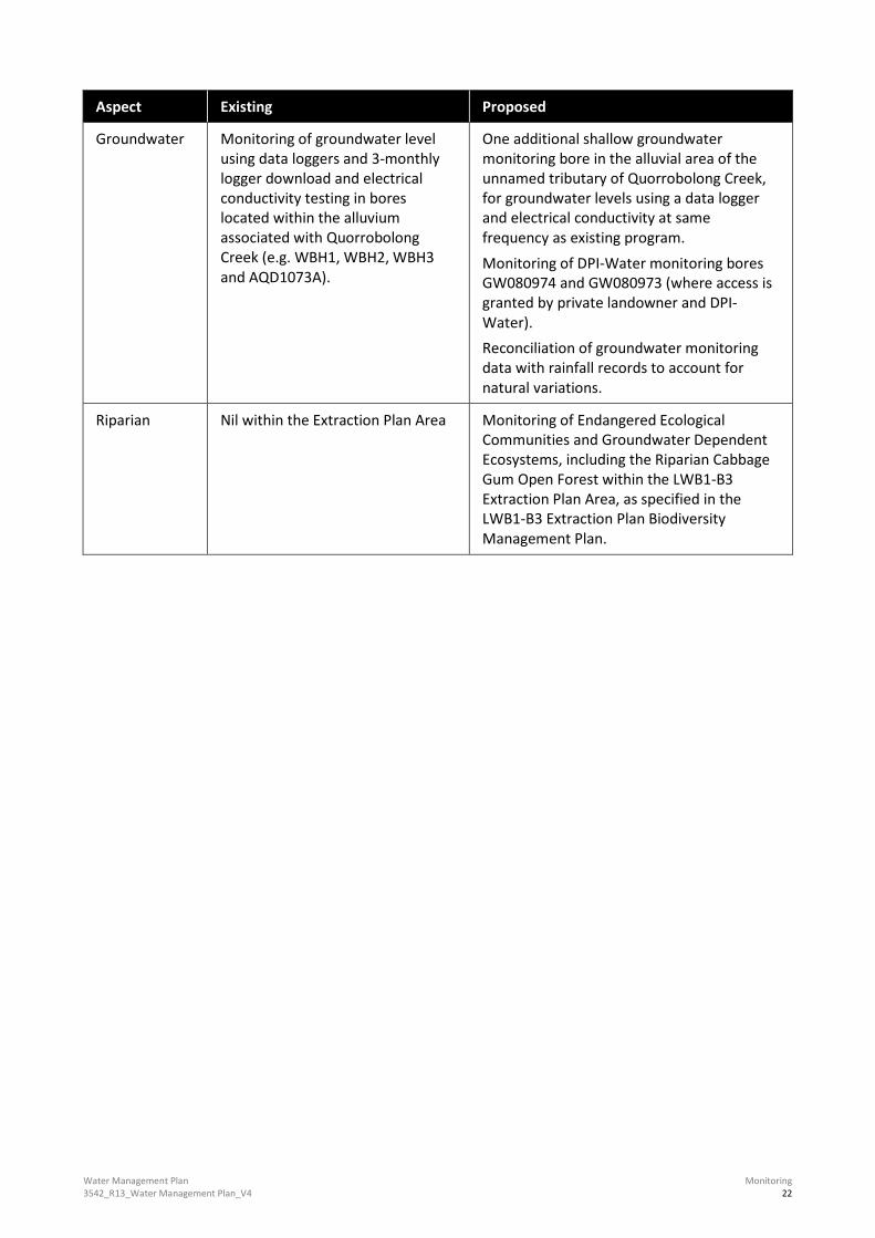
Table 5.1 Existing and Proposed Monitoring Program for the LWB1-B3 Extraction Plan Area
Aspect Existing Proposed
Surface water Monthly water quality sampling at 3 locations along Quorrobolong Creek (SWQ1, SWQ2 and SWQ3). Monthly visual inspections of bank stability and flows within Quorrobolong Creek
Addition of visual inspections of bank stability and flows within the unnamed tributary of Quorrobolong Creek within the Extraction Plan area.
Water Management Plan 3542_R13_Water Management Plan_V4
Monitoring 22
Aspect Existing Proposed
Groundwater Monitoring of groundwater level using data loggers and 3-monthly logger download and electrical conductivity testing in bores located within the alluvium associated with Quorrobolong Creek (e.g. WBH1, WBH2, WBH3 and AQD1073A).
One additional shallow groundwater monitoring bore in the alluvial area of the unnamed tributary of Quorrobolong Creek, for groundwater levels using a data logger and electrical conductivity at same frequency as existing program. Monitoring of DPI-Water monitoring bores GW080974 and GW080973 (where access is granted by private landowner and DPI-Water). Reconciliation of groundwater monitoring data with rainfall records to account for natural variations.
Riparian Nil within the Extraction Plan Area Monitoring of Endangered Ecological Communities and Groundwater Dependent Ecosystems, including the Riparian Cabbage Gum Open Forest within the LWB1-B3 Extraction Plan Area, as specified in the LWB1-B3 Extraction Plan Biodiversity Management Plan.

Water Management Plan 3542_R13_Water Management Plan_V4
Trigger Action Response Plan 23
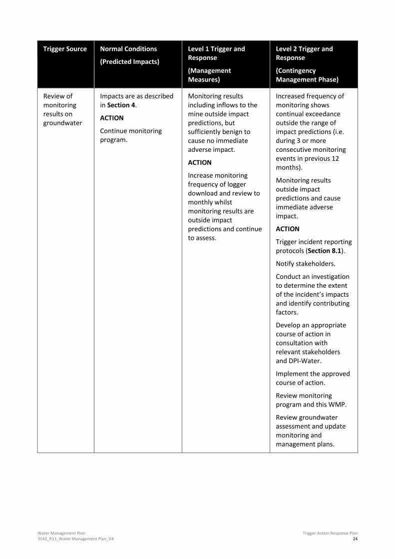
6.0 Trigger Action Response Plan The Trigger Action Response Plan (TARP) identifies response measures for environmental consequences of subsidence impacts on surface water and groundwater. The TARP for the WMP for the Extraction Plan Area is shown in Table 6.1 below.
Table 6.1 WMP Trigger Action Response Plan
Trigger Source Normal Conditions
(Predicted Impacts)
Level 1 Trigger and Response
(Management Measures)
Level 2 Trigger and Response
(Contingency Management Phase)
Review of monitoring results on surface water
Impacts are as described in Section 4.0.
ACTION
Continue monitoring in accordance with WMP and SWMP.
Impacts for Quorrobolong Creek and the unnamed tributary are outside those described in Section 4.0. Deterioration trend on stream health and/or stability.
ACTION
Assess if exceedances are due to mining related activities within the Extraction Plan Area.
If not due to mining related impacts – continue monitoring.
If attributable to mining Proceed to Level 2 Response.
The cause of exceedances of predicted impacts are related to mining activities within the LWB1-B3 Extraction Plan Area.
ACTION
Trigger incident reporting protocols, and remediate as required (Section 8.1):
Notify stakeholders
Develop an appropriate course of action in consultation with relevant stakeholders.
Implement the approved course of action.
Review monitoring program.
Water Management Plan 3542_R13_Water Management Plan_V4
Trigger Action Response Plan 24
Trigger Source Normal Conditions
(Predicted Impacts)
Level 1 Trigger and Response
(Management Measures)
Level 2 Trigger and Response
(Contingency Management Phase)
Review of monitoring results on groundwater
Impacts are as described in Section 4.
ACTION
Continue monitoring program.
Monitoring results including inflows to the mine outside impact predictions, but sufficiently benign to cause no immediate adverse impact.
ACTION
Increase monitoring frequency of logger download and review to monthly whilst monitoring results are outside impact predictions and continue to assess.
Increased frequency of monitoring shows continual exceedance outside the range of impact predictions (i.e. during 3 or more consecutive monitoring events in previous 12 months).
Monitoring results outside impact predictions and cause immediate adverse impact.
ACTION
Trigger incident reporting protocols (Section 8.1).
Notify stakeholders.
Conduct an investigation to determine the extent of the incident’s impacts and identify contributing factors.
Develop an appropriate course of action in consultation with relevant stakeholders and DPI-Water.
Implement the approved course of action.
Review monitoring program and this WMP.
Review groundwater assessment and update monitoring and management plans.

Water Management Plan 3542_R13_Water Management Plan_V4
Trigger Action Response Plan 25
Trigger Source Normal Conditions
(Predicted Impacts)
Level 1 Trigger and Response
(Management Measures)
Level 2 Trigger and Response
(Contingency Management Phase)
Impacts to landowner extraction bore
No significant adverse impact to private bore condition, yield or quality.
ACTION
Nil
Yield post mining (or during as advised by landowner advice/complaint) has decreased.
ACTION
Repeat pumping test and compare with pre-mining hydraulic performance, and determine if impact is due to mining.
If deemed due to mining, Austar to supply alternate water supply until bore can be repaired/replaced in accordance with the respective Built Features Management Plan.
Bore is damaged due to mining impacts and cannot be used.
ACTION
Austar to supply alternate water supply until bore can be repaired/replaced in accordance with the respective Built Features Management Plan.
Feedback from landholders regarding impacts to farm dams
No significant adverse impact to farm dam condition or volume.
ACTION
Nil.
Minor impact to farm dam volumes detected – no interruption to water supply.
ACTION
Farm dam to be repaired in accordance with the respective Built Features Management Plan.
Significant loss of water from farm dam detected.
ACTION
Austar to supply alternate water supply until farm dam can be repaired in accordance with the respective Built Features Management Plan.

Water Management Plan 3542_R13_Water Management Plan_V4
Trigger Action Response Plan 26
Trigger Source Normal Conditions
(Predicted Impacts)
Level 1 Trigger and Response
(Management Measures)
Level 2 Trigger and Response
(Contingency Management Phase)
Subsidence remediation works
Subsidence monitoring program indicates no significant adverse impact which requires remediation.
ACTION
Nil
Subsidence monitoring program review triggers Land Management Plan or Public Safety Management Plan subsidence impact remediation works. Works are not in area considered to be “Waterfront Land”.
ACTION
Restrict access to area in accordance with Public Safety Management Plan processes (where required).
Remediation process is followed in the Land Management Plan and Biodiversity Management Plan.
Nil further requirements from the WMP.
Subsidence monitoring program review triggers Land Management Plan or Public Safety Management Plan subsidence impact remediation works. Works are in area considered to be “Waterfront Land”.
ACTION
Restrict access to area in accordance with Public Safety Management Plan processes (where required).
Consult with DPI-Water regarding works on “Waterfront Land”.
Remediation process is followed in the Land Management Plan and Biodiversity Management Plan, and including any requirements of DPI-Water.

Water Management Plan 3542_R13_Water Management Plan_V4
Roles and Responsibilities 27
7.0 Roles and Responsibilities The key responsibilities of personnel in relation to the LWB1-B3 Extraction Plan WMP are summarised in Table 7.1. Responsibilities may be delegated as required and in line with regulatory limitations.
Table 7.1 Roles and Responsibilities
Responsibility Accountabilities
Operations Manager Ensure appropriate resources are available for the implementation of this WMP.
Technical Services Manager Ensure the Subsidence Monitoring Program is implemented.
Facilitate timeliness and quality of monitoring processes.
Environment and Community Manager Review and seek approval for this WMP in accordance with the requirements of this WMP and other legal requirements and operational standards.
Ensure any incident is reported in accordance with the WMP and other legal requirements.
Instigate response in the event the performance indicators, TARP and/or Contingency Plan are triggered. Allocate resources for monitoring and review of subsidence survey results.
Environment and Community Coordinator Implement monitoring programs as required by this WMP and conduct review of results against performance indicators as described in this WMP.
Assist in the preparation of reports as identified in reporting framework.
Assess any triggers as described in performance indicators and provide advice to implementation of TARPS and the Contingency Plan to Austar Management.
External Groundwater Specialist Review WMP monitoring and management measures and advise on consistency with impact assessment predictions.

Water Management Plan 3542_R13_Water Management Plan_V4
Reporting 28
8.0 Reporting
8.1 Incident Reporting
Exceedances of surface water and groundwater criteria stated in this WMP that have occurred as a result of Austar operations will be classified as environmental incidents and will be managed in accordance with the incident management process as detailed within the Austar Environmental Management Strategy. Austar’s Environmental Management Strategy includes an environmental incident management process to:
• manage environmental hazards and incidents to minimise damage to people, environment, community and other assets
• facilitate reporting of environmental incidents
• identify factors that contributed to incidents through an investigation process and to learn from those events and prevent reoccurrence.
Significant adverse impacts to water resources as a result of Austar operations that exceed the performance criteria of the consent will be treated as an environmental incident, and a written report will be provided to any relevant government agencies in accordance with the Austar Environmental Management Strategy.
In accordance with Condition 4, Schedule 5 of DA 29/95, within 7 days of the incident, Austar will provide the Secretary and any relevant agencies with a report on the incident, and such further reports as may be requested. Incidents will also be reported in accordance with EPL conditions and in accordance with the Austar Pollution and Incident Response Management Plan (PIRMP) where relevant.
8.2 Annual and Regular Reporting
Condition 5 of Schedule 5 of DA 29/95 requires Austar to prepare an Annual Review of environmental performance to the satisfaction of the Secretary of DPE. Annual Review reports are placed on the Austar website and include:
• A description of works carried out during the previous year, planned works for the upcoming year.
• A review of monitoring results and against baseline data, statutory requirements and performance criteria, including a discussion of any trends.
• Identification of any non-compliances and remedial actions.
• Identification of any discrepancies between predicted and actual project impacts.
• A description of any environmental improvement measures or initiatives proposed for the coming year.

Water Management Plan 3542_R13_Water Management Plan_V4
References 29
9.0 References Austar Coal Mine, 2013a. Environmental Management Strategy.
Austar Coal Mine, 2013b. Site Water Management Plan.
Austar Coal Mine, 2013c. Consolidated Environmental Monitoring Program.
Dundon Consulting, 2015. Austar Coal Mine – LWB1-LWB3 Modification – Groundwater Assessment.
Geoscience Australia. 1988. Australian Stratigraphic Units Database. [ONLINE] Available at: http://dbforms.ga.gov.au/pls/www/geodx.strat_units.sch_full?wher=stratno=2498. [Accessed 25 August 2015].
Kovac, M. and Lawrie, J., 1991. Soil Landscapes of Singleton 1:250,000 Sheet. Soil Conservation Service of NSW, Sydney.
Mine Subsidence Engineering Consultants (MSEC), 2011. Austar Coal Mine: Stage 3 – Longwalls A7-A19 Subsidence Predictions and Impact Assessments for Natural Features and Surface Infrastructure in Support of a Modification to the Development Consent.
Mine Subsidence Engineering Consultants (MSEC), 2015. Austar Coal Mine: Longwalls B1 to B3 Subsidence Predictions and Impact Assessments for the Natural Features and Built Features in Support of the Environmental Assessment for a Section 75W Modification Application for the Inclusion of the Proposed Longwalls B1 to B3 at the Austar Coal Mine.
NSW Department of Planning and Environment, 2016. Assessment Report Austar Coal Mine Additional Longwalls Modification (DA 29/95 MOD 6).
RPS, 2014. Austar Coal Mine – EL6598, Groundwater Monitoring and Modelling Plan. Dated March 2014.
Umwelt, 2015. LWB1-B3 Modification Environmental Assessment Austar Coal Mine.