water resources and water utilization in bangladeshtasae/2006/bangladesh.pdf · 2006-11-28 ·...
TRANSCRIPT

Utilization and Conservation of Water Resources in Bangladesh
Abu Musa Md. Motaher AHMED1∗, Ph.D and Kingshuk ROY, Ph.D2
1Senior Scientific Officer, River Research Institute, Faridpur 7800, Bangladesh
(Tel.: +880 631 63580 Ext. 246, Fax: +880 631 63065, E-mail: [email protected])
2Associate Professor, College of Bioresource Sciences, Nihon University, 1866 Kameino, Fujisawa, Kanagawa 252-8510, Japan
(Tel & Fax: +81 466 84 3467, E-mail: [email protected]) Utilization of water resources in Bangladesh depends on its availability and conservation depends on the storability subject to upstream conditions of the lower riparian countries. Bangladesh is located at the lower riparian country of the three major internationally famous rivers, namely the Ganges, the Brahmaputra and the Meghna. Management and development of the water resources of the country is completely dependent on the availability of water from the Transboundary Rivers and rainfall distribution round-the-year. It has been recognized that Bangladesh experiences water shortage in the dry season and water abundance in the wet season which disrupt significantly the agro-environmental practices and socio-economic activities of the country. To address the problems encountered due to such water shortage or abundance, cooperation among the co-basin countries is needed, as well as proper utilization and conservation of water resources has to be practiced. Agro-environmental education now-a-days should focus these issues in the perspective of Bangladesh as well as in the global respect. This paper describes the problems of water resources management and development, utilization and conservation options based on available data and information in the context of Bangladesh; and possible remedial measures to address and overcome the problems have been discussed. Keywords: water demand, water supply, water conservation, water utilization, agro-environmental 1. Introduction In agro-environmental practice water resources play key role over the other variables. Agricultural activities and most of the environmental issues are related to water. So water availability and its proper utilization is a major concern for sustainable development of agriculture. Agriculture and environment are always interrelated and these two broad areas should be priori considered in planning and evaluation of any agricultural projects. Water resources management and its proper utilization improve the agro-environmental conditions of a country. Compliance with the policy is intended to ensure that the development and management of the nation’s water resources include the protection, restoration and preservation of natural habitats and their dependent bio-diversity with specific provisions for wetlands, mangrove and other forests, endangered species and water quality. Utilization of water resources in Bangladesh depends on its availability and conservation depends on the storability due to upstream conditions of the lower riparian countries. Water conservation consists of actions that reduces the demand of water, improve efficiency in use and reduces losses and waste, and improves land management practices to conserve water. The natural subsystem of water resources system are: 1) the interlinked system of rivers, estuaries, canals, khals (smaller than rivers in size) etc. 2) the floodplain 3) wetlands 4) haor, baor, beel (local names of different kinds of ponds filled with stagnant rain water), lakes etc. 5) ponds 6) inter
∗ Corresponding author
tidal lands and water 7) groundwater aquifers. However, other than rivers, the natural reservoirs are scarce and thereby water conservation in rainy season for dry season use is limited. Water resources management is now a global concern, the main purpose of which is to provide adequate water for humans and the natural environment. The water management includes water utilization, water source conservation, monitoring and preservation of water quality. In this paper the overall status of water resources of Bangladesh and its utilization in different areas with emphasis to conservation is described based on available information. 2. Water resources and Agricultural information 2.1 Geographical and water resources information Bangladesh lies in the northeastern part of South Asia between 20034′ and 26038′ north latitude and 88001′ and 92041′ east longitude. The country is bounded by India on the west, the north and the northeast; Myanmar on the southeast and the Bay of Bengal on the south. The area of the country is 147,570 sq.km. The country is the lowest riparian of the Ganges basin, the Brahmaputra basin and the Meghna basin. Most of its area is low lying floodplain formed by the alluvial soil deposited by three great rivers, namely the Brahmaputra/Jamuna, the Ganges and the Meghna. These rivers drain a catchment area of about 1.72 million km2 in India, Nepal, China, Bhutan and Bangladesh; only 8 percent of the catchment area lies within Bangladesh. These major rivers and their tributaries have their headwaters outside Bangladesh as shown in Fig.1, with about 90% of their annual flow originating outside the country. This flow has a huge annual variation, with the combined flow of the Ganges and the Brahmaputra typically increasing from less than 10,000 cumecs early in the year to a peak of 80,000 to 140,000 cumecs by late August to early September. Shortage of water in the dry season in Bangladesh is exacerbated by the diversion of water at the Farakka Barrage, just upstream of where the Ganges enters Bangladesh. The country contains about 22155 km of river length for about 700 rivers. The river system of Bangladesh is shown in Fig.2.Rivers and water bodies occupy about 5% of the land surface. The land topography is almost flat with little hilly areas in the southeastern part. The country enjoys tropical monsoon climate with two prominent seasons; dry season (November-May) and wet season (June-October). Bangladesh is predominantly an agricultural country; about 54% of the lands are used for crop production. Up to 85% of the annual rainfall occurs between June and September. Mean annual rainfall ranges from about 1200 mm in the west to almost 6000mm in the northeast. The average annual rainfall in the Himalayas and in the Meghalaya hills to the north of Bangladesh reaches about 10,000mm. About 25% of the country is flooded to varying degrees each year during May through September when over 60% of the cereals is produced. Recurrent flooding severely restricts the farmers’ choice of cropping to traditional low yielding broadcast variety of rice that can thrive in deep water and, in fact, the coverage is dominated by it. The real production potential is not harnessed due to flood depth. On the other hand, scarcity of irrigation water during March-April limits the cultivation of High Yielding Variety rice which accounts for about 36% of total rice production. 2.2 Bangladesh’s problems as a Lower Riparian in the Basins As the lower riparian of the major rivers, Bangladesh is located at the point of concentration for monsoon floods generated by runoff from the Himalayas. Continued development of
upstream basins will increase the disadvantages of being the lower riparian and floods are likely to increase because of deforestation of the Himalayas, land degradation and erosion. On the other hand, during the October-May lean period Bangladesh receives only the residual flow after diversion and upstream use. Reduction of dry season flows in Bangladesh due to increasing upstream withdrawal is causing severe water shortage across the country and in the South West region in particular, reduced stream flow is also aggravating salinity intrusion and environmental degradation. 2.3 Agricultural information The landscape of Bangladesh is broadly grouped into three land forms. These are hill areas accounting for 12%, terrace areas covering 8%, and floodplain areas covering 80%. Total land areas of Bangladesh are 14.8 million hectares of which 9.5 million hectares are available for cultivation and 7.5 million ha of land are subject to potential irrigation. Six million ha are subject to flooding ranging from 30 cm to in access of two meters. The time of arrival, depth, duration of flooding and the rate of rise largely determine the choice and timing of crops. Diversified cropping pattern is in practice in Bangladesh from time immemorial. Cropping patterns is essentially rice based and most non-rice crops are grown in sequence with rice in one or even two seasons. Apart from different varieties of seasonal rice, non-rice crops grown in the country include nearly a hundred types of fruits, vegetables, pulses, oilseeds, spices, jute, sugarcane, potato, tobacco, millets, wheat etc. Agro-climatic condition in the kharif season (April-July/August) acts in favor of rice, non-rice crops with the exception of jute can not be grown in these seasons. Most non-rice crops are grown in the rabi season (December-May) when hydrological regime is one of the major factor in the selection of crop type. 3. Sources of water in Bangladesh In Bangladesh, the sources of water are surface water and ground water. Both the sources may be fresh or saline. 3.1 Surface water Surface water sources are categorized as rainfall, transboundary flow, water on standing water bodies (water storage in reservoir, water bodies such as river, lake and pond), water on seasonal wetlands, and in-stream storage. These are describes below: i) Rainfall Average annual rainfall of the country is about 2360 mm (1960-1997). Yearly variation of annual rainfall is shown in Fig.3. Regional distribution of annual rainfall is shown in Table 1. This table shows that northwest and southwest region of the country receives less rainfall compared to other parts. About 20% of the average annual rainfall occurs in dry season (November-May) in northwest region but the monthly distribution of this amount is highly uneven. ii) Transboundary flow Bangladesh shares 57 transboundary rivers, 54 incoming from India, 3 from Myanmar. Among the rivers, the Ganges, the Brahmaputra and the Meghna drain about 1.08 million sq.km., 0.58 million sq.km. and 0.09 million sq.km. respectively. Total annual volume of water that enters into the country from the transboundary rivers is about 1000 billion cubic
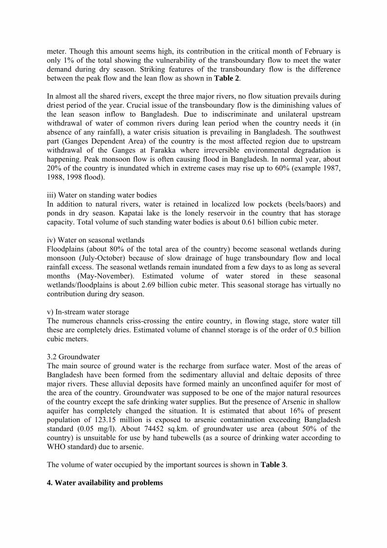
meter. Though this amount seems high, its contribution in the critical month of February is only 1% of the total showing the vulnerability of the transboundary flow to meet the water demand during dry season. Striking features of the transboundary flow is the difference between the peak flow and the lean flow as shown in Table 2. In almost all the shared rivers, except the three major rivers, no flow situation prevails during driest period of the year. Crucial issue of the transboundary flow is the diminishing values of the lean season inflow to Bangladesh. Due to indiscriminate and unilateral upstream withdrawal of water of common rivers during lean period when the country needs it (in absence of any rainfall), a water crisis situation is prevailing in Bangladesh. The southwest part (Ganges Dependent Area) of the country is the most affected region due to upstream withdrawal of the Ganges at Farakka where irreversible environmental degradation is happening. Peak monsoon flow is often causing flood in Bangladesh. In normal year, about 20% of the country is inundated which in extreme cases may rise up to 60% (example 1987, 1988, 1998 flood). iii) Water on standing water bodies In addition to natural rivers, water is retained in localized low pockets (beels/baors) and ponds in dry season. Kapatai lake is the lonely reservoir in the country that has storage capacity. Total volume of such standing water bodies is about 0.61 billion cubic meter. iv) Water on seasonal wetlands Floodplains (about 80% of the total area of the country) become seasonal wetlands during monsoon (July-October) because of slow drainage of huge transboundary flow and local rainfall excess. The seasonal wetlands remain inundated from a few days to as long as several months (May-November). Estimated volume of water stored in these seasonal wetlands/floodplains is about 2.69 billion cubic meter. This seasonal storage has virtually no contribution during dry season. v) In-stream water storage The numerous channels criss-crossing the entire country, in flowing stage, store water till these are completely dries. Estimated volume of channel storage is of the order of 0.5 billion cubic meters. 3.2 Groundwater The main source of ground water is the recharge from surface water. Most of the areas of Bangladesh have been formed from the sedimentary alluvial and deltaic deposits of three major rivers. These alluvial deposits have formed mainly an unconfined aquifer for most of the area of the country. Groundwater was supposed to be one of the major natural resources of the country except the safe drinking water supplies. But the presence of Arsenic in shallow aquifer has completely changed the situation. It is estimated that about 16% of present population of 123.15 million is exposed to arsenic contamination exceeding Bangladesh standard (0.05 mg/l). About 74452 sq.km. of groundwater use area (about 50% of the country) is unsuitable for use by hand tubewells (as a source of drinking water according to WHO standard) due to arsenic. The volume of water occupied by the important sources is shown in Table 3. 4. Water availability and problems

4.1 Surface water availability and problems The natural surface water resources in Bangladesh are mainly derived through the major river systems and their tributaries. The flow distribution characteristic in the river system is a combination of upstream inflows and run-off generated from rainfall within Bangladesh. In the southern regions, the distribution is also affected by tidal conditions. Surface water is abundant in the wet season in Bangladesh. An estimated 795,000 million cubic meter (Mm3) of surface water is discharged per year through the Ganges-Brahmaputra system, in the downstream of the confluence of the Ganges and the Brahmaputra. This is equivalent to 5.52m deep water over a land area of 144,000 km2. There are other rivers discharging surface water into the Bay of Bengal. In dry season country suffers from acute shortage of both surface and groundwater (BUET, 2004). Bangladesh experiences four main types of floods: monsoon floods from the major rivers; local flooding due to drainage congestion, flash floods in the eastern and northern rivers; floods caused by high tides and storm surges in the coastal areas. During the June-September monsoon, Bangladesh receives about 80% of annual precipitation, averaging 2300mm, but varying from as little as 1200mm in the west to over 5000mm in the east. Runoff from adjacent riparian is generated by rainfall which averages 5000mm over the Himalayas, and exceeds 10,000mm over the Meghalaya plateau north to Sylhet. Together inflows and rainfall causes peak floods in the Ganges, Brahmaputra and Meghna rivers in the period July-August, and on average 22% of the country is flooded annually. Drought is also a problem in Bangladesh, particularly in the North West regions during the spring where there are few surface water resources, and agricultural production is heavily reliant on groundwater resources. However, drought is not only confined to the dry season, and scanty rainfall during the monsoon, as happened in 1994, but also severely affects floodplain fisheries and late monsoon aman rice. Groundwater recharge for the following dry season is also adversely affected. 4.2 Groundwater availability and problems Groundwater is the main source of water supply in urban and rural areas of Bangladesh. Except for few hilly regions Bangladesh is entirely underlain by water bearing aquifers at depths varying from zero to 20m below ground surface. Groundwater in Bangladesh is available in adequate quantity, but the availability of groundwater for drinking purposes has become a problem for the following reasons (BUET, 2004):
• Arsenic in groundwater; • Excessive dissolved iron; • Salinity in the shallow aquifers in the coastal areas; • Lowering of groundwater level; • Rock/stony layers in hilly areas;
So, it may be said that in spite of heavy rainfall, readily accessible groundwater and large river systems in this country, at present water scarcity for drinking purpose is the major problem in Bangladesh due to arsenic contamination in groundwater and surface water pollution by point sources and non-point sources. 4.3 Water resources development

On an annual basis, the water theoretically available to Bangladesh is huge in relation to demands. The annual rate of reference crop evapotranspiration (ET0) is around 1500 mm/year and the annual average rainfall is some 2200mm. In addition, a volume of some 1010 Billion m3 enters the country in the 57 rivers which cross its border with India and Myanmar, which corresponds to a further 6800mm over its surface of 147,570 km2, for a total of 9000mm, four times ET0. Regional balance of rainfall and evapotranspiration as presented in Table 4 shows water abundance in wet season and shortage in dry season. The surface water available for development in the regional rivers in the dry season (November to May) was estimated by the Master Plan Organization (MPO) for the period 1989-1990 as shown in Table 5. These figures are small when divided by the net cultivable area (NCA in Mha) in each region, and compared with ET0 as shown in Table 6. In the South West, the surface water available in March of 7 mm and the dependable rainfall of 27 mm, together amount to only 22% of ET0. However, there is a large groundwater reservoir, which is replenished by monsoon rainfall and flooding, and is tapped by shallow tubewells (STW) in the dry season. 5. Water demand and supply Demands arise from several factors such as, natural (evapotranspiration), water supply, irrigation, fisheries and livestock, industrial, navigation and the environment (demands for salinity control). Proportion of total water demands, as projected for 2025, is estimated to be: instream-56%, agriculture-32%, environment-9% and water supply-3%. So, consumptive use comes to be 44%. Environmental flow requirements according to IUCN as stated by Saleh (2003) should at least be 30% of the world’s river flows so as to maintain a fair condition of freshwater ecosystems. If we compare the rainfall and reference crop evapotranspiration we can see the situation of water demand and supply. The reference crop evapotranspiration and rainfall during the critical months (when it exceeds the rainfall) is given region-wise in Table 7, which shows that supply of water in the driest periods in the whole country is much less than demands. Water demand for agriculture amounts to about 70% of the global withdrawal; for Bangladesh, the figure is about 80% (November to March withdrawal). Water use in Bangladesh agriculture has increased by 2.73 times in 2001 relative to 1991 according to IRRI as reported by Saleh (2003). Water balance, on yearly basis, shows a clear deficit for the entire country. This picture would be alarming if the same is done for driest period of the year. In the absence of significant storage for water in Bangladesh, water balance calculations are normally made on a monthly basis. Table 8 shows the projected demand and supply in the month of March in 2018 according to MPO (1991). Still the projected water supply is found to be less than demand. 6. Water conservation and regional development options Water conservation is necessary for agriculture, hydro-power and recreation, environment and preservation of wetlands. Bangladesh’s overall agricultural policy objective is to expand

and diversify agricultural production and to maintain food security, especially with regard to sustaining near self-sufficiency in rice. Irrigation has been the major water sector contributor to agricultural growth. Groundwater irrigation is limited to about 56% of the country and the main concerns are whether this will need to be curtailed due to possible arsenic contamination. Surface water is the cheapest form of irrigation providing water is available nearby in sufficient quantities. It is applicable to 44% of the country where groundwater is not available and to those parts of the groundwater areas where deficits may be expected due to low recharge or arsenic limitations. Most of the NE, SE and SW regions are dependent upon surface water. Parts of the NW and NC regions would also require surface water. First priority can therefore be assigned to development of surface water resources in the SW by utilizing Ganges waters and second to the NE and SE regions by utilization of Meghna waters. Through the development of barrages on the Jamuna, Ganges and Padma can conserve water resources to use in the dry season. Such development in the Eastern Hills is also needed as this region has little groundwater. Higher dry season water levels in the reservoir will ensure lower irrigation water pumping costs, rises in dry season groundwater levels in land adjacent to the reservoir and increased water level will increase water retention of ponds adjacent to river. Region-wise water-related issues has been sorted out in National Water Management Plan as presented in Table 9 so as to address them in the future. National Water Policy has been undertaken to address the above issues by:
• Harnessing and development of all forms of surface and ground water and management of these resources in an efficient and equitable manner
• Ensuring the availability of water to all • Accelerating the development of sustainable public and private water delivery
systems • Developing a state of the art knowledge and capability that will enable the country to
design future water resources management plans Water Resources Planning Organization (WARPO) is an organization, which was created in 1992 to perform planning of water resources by:
• Preparing environmentally compatible master plan for water resources development • Formulating strategy and policy for scientific utilization and conservation of water
resources • Assisting the organizations/agencies involved in utilization, conservation and
development of water resources, in conducting studies and, if necessary, to conduct special studies on any related issue
• Collecting and analyzing data and information on water resources and arrange for dissemination
7. Conclusions Due to its geographical location, Bangladesh experiences water abundance in the wet season and lack in dry season. These are two major conflicts in water resources management of the country. These two major conflicts can be overcome by conserving required amount of water in the wet season by building more barrages across the rivers as well as by dredging or by

developing the rivers and spilling additional amount. The water conservation practice in Bangladesh still needs attention as the country is geographically dislocated. Moreover, cooperation among the co-basin countries is necessary for sharing of Transboundary river flows. For instance, if appropriate measures are not taken urgently to restore Bangladesh’s rightful share of the Ganges, it may face further morphological and environmental hazards especially in the southwestern part of the country. Diversion of water in Meghna at the Barak dam could have effects on the eastern region. Efficient water and flood management and assured shares of the dry season flows of the Transboundary Rivers have, therefore, become imperative for the survival of Bangladesh. Interception of flood waters by upstream storage is crucial need for augmentation of dry season flow, power generation, comprehensive development and harnessing of water resources of Bangladesh. 8. Recommendations As the lower riparian state of three major river systems, Bangladesh should work with its neighbors towards overall basin management, with an early focus on the different hydrological regions and promoting information exchange. Although Signature of Ganges Water Treaty in 1996 is an important milestone, continued efforts are needed to secure Bangladesh’s share of the flows of the other 53 transboundary rivers. The National Water Management Plan has to address and balance the conflicting needs of too much water in monsoon and too little in the dry season which would need tapping the resources of both surface and ground water. Acknowledgements The authors are grateful to Water Resources Planning Organization (WARPO) for supplying the necessary data and information for preparing this paper. References Ahmed, M. F., 1999. Rainwater harvesting potential in Bangladesh, Proceedings of the WEDC Conference on Integrated Development of Water Supply and Sanitation, Addis Ababa, Ethiopia, 363-365. BUET, 2004. Water Supply Situation Analysis, Online Publication (URL: http://www.buet.ac.bd/itn/publications/as_mitigation/as_mitigation_part4_2.pdf), Bangladesh University of Engineering and Technology, Dhaka, Bangladesh. MPO, 1991. National Water Plan, vol-2, Master Plan Organization, Ministry of Irrigation, Water Development and Flood Control, Government of the People’s Republic of Bangladesh. Saleh, A.F.M., 2003. Lecture notes on Water Management and Agriculture, Short course on Integrated Water Resources Management, BUET, Dhaka, 18pp.
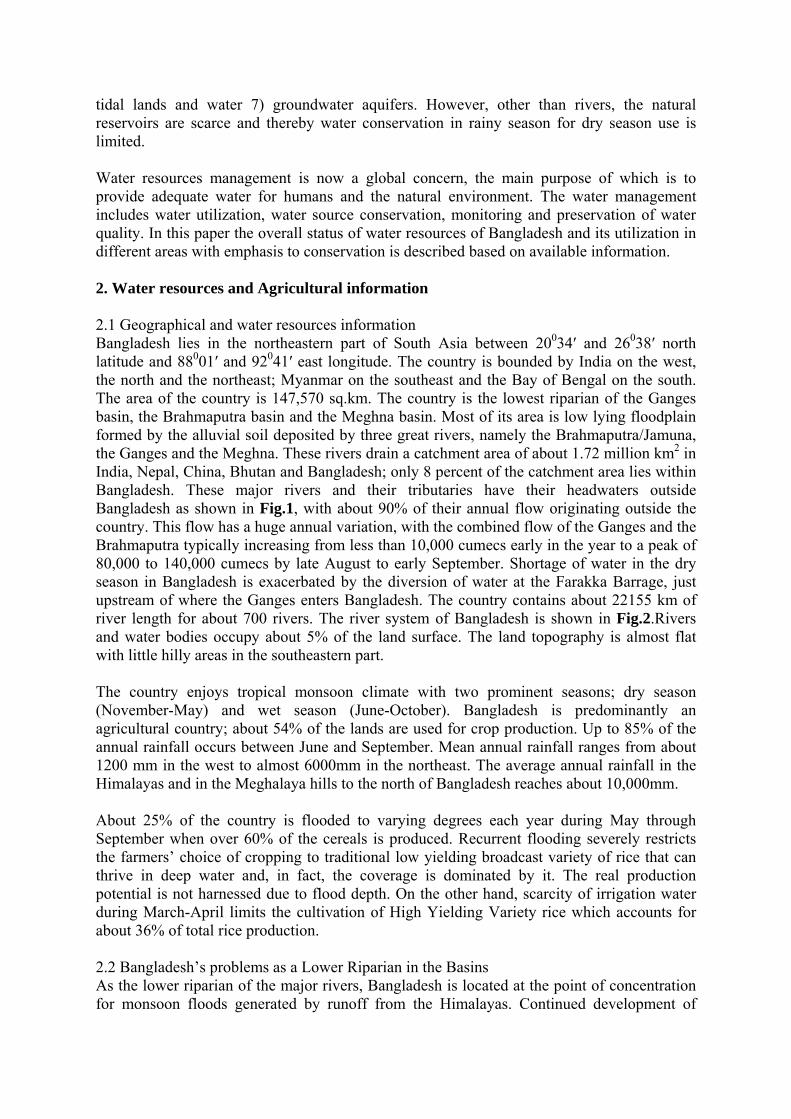
Table 1: Rainfall of the country, mm
Region of the country Season NW NC NE SW SC SE EH
Average
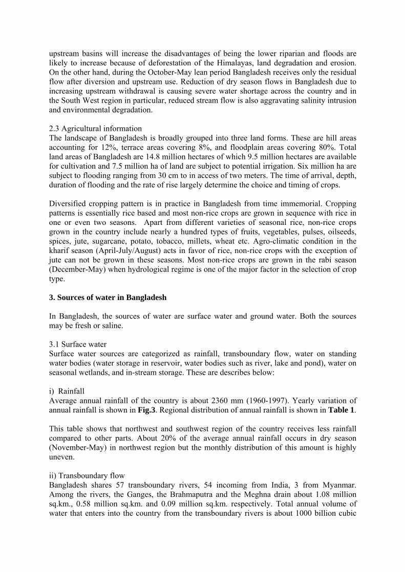
Wet 1393 1445 2297 1299 1821 1683 1934 1856 Dry 346 511 897 366 486 588 511 504 Annual 1739 1956 3194 1665 2307 2271 2445 2360 NW-North West, NC-North Central, NE-North East, SW-South West, SE-South East, SC-South Central, EH-Eastern Hills Table 2: Peak and lean flow in the major rivers River Station Peak flow
(m3/s) Lean flow (m3/s)
Lean flow (% of peak)
Ganges Hardinge 76000 526 0.7 Brahmaputra Bahadurabad 102534 2860 2.79 Meghna Bhairab Bazar 19800 - - Table 3: Volume of water occupied by the important sources
Source Transboundary Rainfall Groundwater Volume in million cubic meter
1,050,000 343,000 23,000
Volume in percent 74% 24% 2% Table 4: Regional balance of rainfall and evapotranspiration Region Rainfall, mm Evapotranspiration, mm Deficit, mm Wet Dry Wet Dry Wet Dry NW 1881 156 795 679 -1116 523 NE 2594 368 776 700 -1818 432 SW 1792 183 816 719 -974 536 SE 2661 260 866 785 -1795 525 Table 5: Surface water available for development in volume (1989-1990) Surface water available for development (Mm3) Region Nov Dec Jan Feb Mar Apr May NW 2,970 1,840 1,160 780 780 920 2,210 NE 5,090 1,710 710 130 230 2,480 9,680 SE 820 950 750 640 650 630 1,090 SC 8,250 4,440 3,050 2,020 2,320 3,760 7,680 SW 1,180 580 270 140 120 100 230 Total 18,310 9,520 5,940 3,710 4,100 7,980 20,890 Table 6: Surface water available for development in depth (1989-1990) Surface water available for development (mm on cultivable area) Region NCA
(Mha) Nov Dec Jan Feb Mar Apr May
NW 2.451 121 75 47 32 32 38 90

NE 2.573 198 66 28 5 9 96 376 SE 1.313 62 72 57 49 50 48 83 SC 1.026 804 433 297 197 226 366 749 SW 1.666 71 35 16 8 7 6 14 ET0 - 102 87 88 107 155 175 180 Table 7: Regional monthly ET0 and Rainfall (mm) ET0/Rainfall Region
Nov Dec Jan Feb Mar Apr
SE 80/39 65/11 70/6 86/24 132/60 - NW 79/12 65/7 67/8 85/11 136/22 164/72 NC 80/23 66/11 70/6 87/21 136/40 159/127 RT 83/38 70/11 74/6 90/20 136/48 157/130 SW 84/31 72/11 76/9 92/23 145/36 173/80 NE 78/32 65/13 68/9 85/31 128/82 - SC 81/53 71/11 75/7 90/23 135/46 152/115 EH 88/59 79/11 85/5 98/17 140/44 153/124
Table 8: Projected water supply and demand in the month of March Projected water supply and demand, March 2018 (MPO 1991) Water requirements Mm3 % Water supplies Mm3 % Agriculture 14,290 58.6 Main rivers 11,740 50 Navigation, Environment and Fisheries
9,910 40.7 Regional rivers 6,390 27
Domestic uses and industry
170 0.7 Groundwater 5,360 23
Total 24,270 100 Total 23,490 100 Table 9: Region-wise water-related issues
Region Issues SW Preservation of the Sundarbans, restoration of dry season fresh water inflows,
maintenance of the coastal embankment system, alleviation of coastal drainage congestion, improved cyclone protection, flood proofing in the low lying areas
NE Environmental management of the Haor basin, flood proofing, erosion of old Brahmaputra left bank, drainage congestion in the rivers, hill irrigation
NC Bulk water supplies and pollution control in Dhaka city, flooding and drainage problems, flood proofing in low lying areas
NW Erosion along the right bank of the Brahmaputra, flooding and drainage problems, drought in the western fringes, flood proofing in the low lying areas
SC Siltation and drainage congestion, improved cyclone protection, flood proofing in low areas
SE Gaseous aquifers, cyclone protection, drainage congestion, protection of newly accreted lands against tidal flooding
Eastern Hills
Small scale irrigation development, mini-hydro power development, improved cyclone protection,
Rivers and Estuary
Erosion protection, regional augmentation, flood proofing, cyclone protection in Meghna estuary, erosion of Meghna river, protection of newly accreted lands

Fig.1 The Ganges-Brahmaputra-Meghna river basins

Fig.2 River systems in Bangladesh

RAINFALL PATTERN Average Rainfall
Fig.3 Variations of annual rainfall in Bangladesh (Source: Ahmed, 1999)