water safety plan water supply description assessment -water supply system... · water safety plan...
TRANSCRIPT
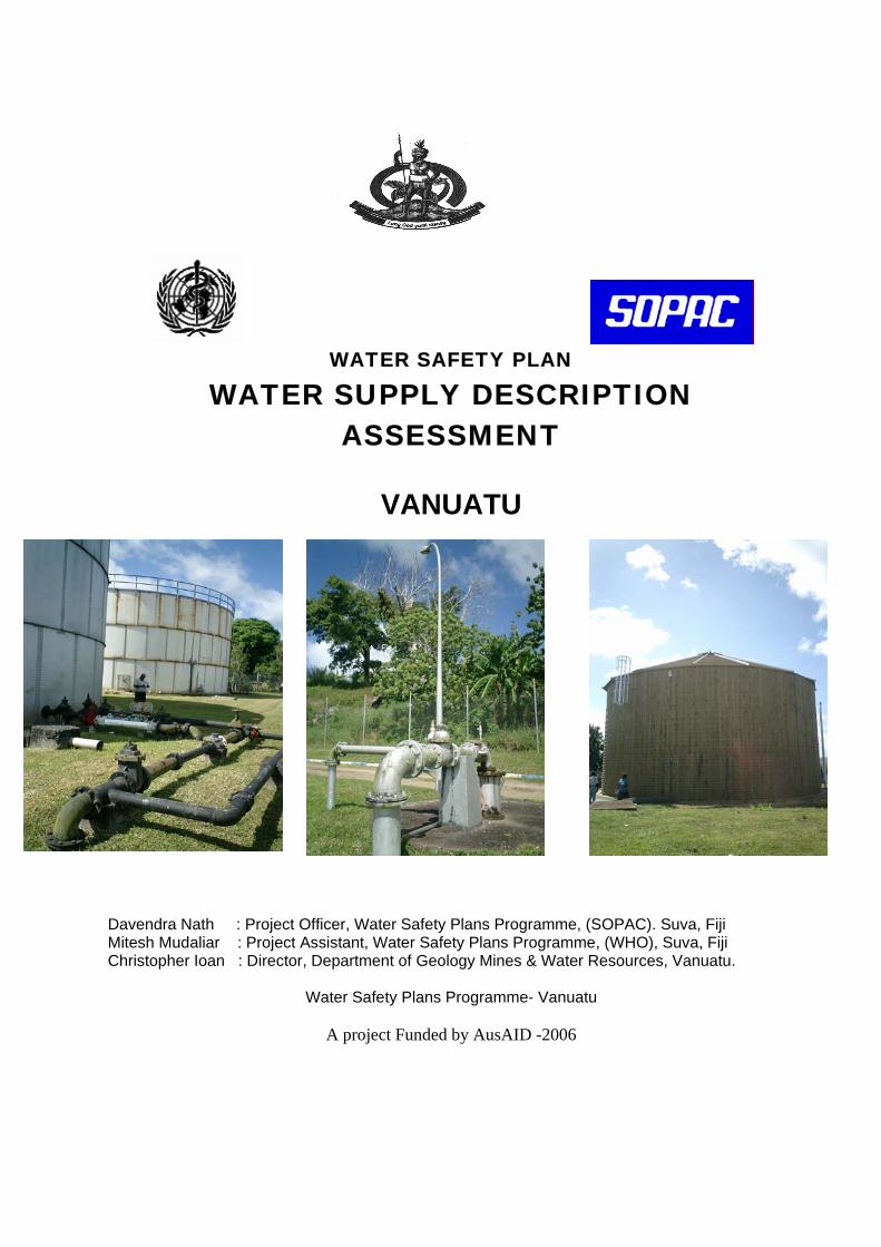
WATER SAFETY PLAN
WATER SUPPLY DESCRIPTION ASSESSMENT
VANUATU
Davendra Nath : Project Officer, Water Safety Plans Programme, (SOPAC). Suva, Fiji Mitesh Mudaliar : Project Assistant, Water Safety Plans Programme, (WHO), Suva, Fiji Christopher Ioan : Director, Department of Geology Mines & Water Resources, Vanuatu.
Water Safety Plans Programme- Vanuatu
A project Funded by AusAID -2006
2
Table of Contents
1 Introduction 1.1 Background 1.2 Climate and Geology 1.3 Groundwater Resources 2 Water Supply System Assessment 2.1 Port Vila Urban Supply 2.1.1 Catchment and Intake 2.1.2 Storage and Treatment 2.1.3 Distribution 2.2 Mele Rural Supply 2.2.1 Background 2.2.2 Catchment and Intake 2.2.3 Storage and Treatment 2.2.4 Distribution
2.3 Luganville Water Supply 2.3.1 Catchment and Intake
2.3.2 Storage and Treatment 2.3.3 Distribution
2.4 Main Objective of Luganville System Improvement 2.5 Water Resource Monitoring 2.6 Water quality Monitoring
3. Water Safety Planning 4. Improvements Needed 5. Conclusion 6. References
3
1. INTRODUCTION Vanuatu is chosen as on of the four pilot countries for the Pacific Water safety Plans programme which is for two years and focuses on the provision of safe drinking water. A one week scoping mission and workshop was successfully carried out with the commitment of national government and all other stakeholders for the water supply. One pilot site was chosen for the rural and one for the urban area and it was envisaged that replication will follow within the country for all the remaining water supplies.
The importance of safe drinking water for health and development in the Pacific Island Countries has been reflected in many regional action plans and policies. Through the Regional Action Plan on Sustainable Water Management (Sigatoka, Fiji, 2002) Pacific Island Countries outlined actions that were needed to achieve sustainable water management through collaborative efforts by water sector authorities and inter-sectoral partners.
The WHO workshop on Drinking Water Quality Standards and Monitoring in Pacific Island Countries (Nadi, Fiji, 2005) developed a Framework for Action on Drinking Water Quality and Health in Pacific Island Countries, designed to support the implementation of drinking water quality actions envisioned in the RAP.
The Pacific Island Countries embraced the Water Safety Plan concept during the workshop and this was reflected in the Regional Framework. It was recommended that PICs should use Water Safety Plans to better manage their water supplies to ensure safe quality drinking water for Pacific communities.
The Pacific Water Safety Plans Programme is a joint initiative of the Pacific Applied Geo-science Commission (SOPAC) and the World Health Organization (WHO), Suva Fiji.
Funded by AusAID, the programme is a response to the regionally endorsed Framework for Action on Drinking Water Quality and Health and will be implemented over the period 2006-2007.
Water Safety Plans (WSP) as promoted by WHO in the Guidelines for Drinking Water Quality (Third Edition) ,are tools that allow for proactive measures to ensuring safety of a drinking water supply using risk assessment and risk management approaches to identify risk of contamination of water supply and allow for sufficient mechanisms to manage these risks. The primary objective of a Water Safety Plan is to minimise contamination of water sources, and prevent or remove contamination during treatment, storage and distribution. These objectives are equally applicable to large reticulated water supplies; smaller community managed systems and as well as for individual household systems.
4
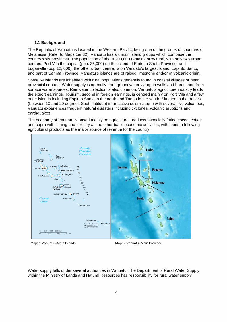
1.1 Background The Republic of Vanuatu is located in the Western Pacific, being one of the groups of countries of Melanesia (Refer to Maps 1and2). Vanuatu has six main island groups which comprise the country’s six provinces. The population of about 200,000 remains 80% rural, with only two urban centres. Port Vila the capital (pop. 36,000) on the island of Efate in Shefa Province, and Luganville (pop.12, 000), the other urban centre, is on Vanuatu’s largest island, Espirito Santo, and part of Sanma Province. Vanuatu’s islands are of raised limestone and/or of volcanic origin.
Some 69 islands are inhabited with rural populations generally found in coastal villages or near provincial centres. Water supply is normally from groundwater via open wells and bores, and from surface water sources. Rainwater collection is also common. Vanuatu’s agriculture industry leads the export earnings. Tourism, second in foreign earnings, is centred mainly on Port Vila and a few outer islands including Espirito Santo in the north and Tanna in the south. Situated in the tropics (between 10 and 20 degrees South latitude) in an active seismic zone with several live volcanoes, Vanuatu experiences frequent natural disasters including cyclones, volcanic eruptions and earthquakes.
The economy of Vanuatu is based mainly on agricultural products especially fruits ,cocoa, coffee and copra with fishing and forestry as the other basic economic activities, with tourism following agricultural products as the major source of revenue for the country.
Map: 1 Vanuatu –Main Islands Map: 2 Vanuatu- Main Province
Water supply falls under several authorities in Vanuatu. The Department of Rural Water Supply within the Ministry of Lands and Natural Resources has responsibility for rural water supply
5
systems countrywide. The Public Works Department under the Ministry of Public Utilities and Infrastructure is responsible for the Luganville town piped water supply and for a number of provincial centres countrywide. UNELCO is a French-owned private utility contracted by government to provide electricity to the two urban centres. For 12 years UNELCO has also managed and operated the Port Vila water supply system. The Ministry of Health (MoH) is responsible for water quality surveillance of all water supply systems, reinforced by the 1994 Public Health Act.
Climate and Geology The average rainfall varies from 4000mm per annum in North to only 1500 mm in the southern islands. An extended dry season occurs during April to December with little rain occurring that time.
Rivers and creeks are quite common, especially on the larger islands. The flow is seasonal, and is often very close to villages. These sources carry water from inland spring sources to coastal area, where the majority of the population is located. The quality of surface water is often contaminated from upstream. This may be from humans or animals using the creeks or its vicinity for drinking or defecation.
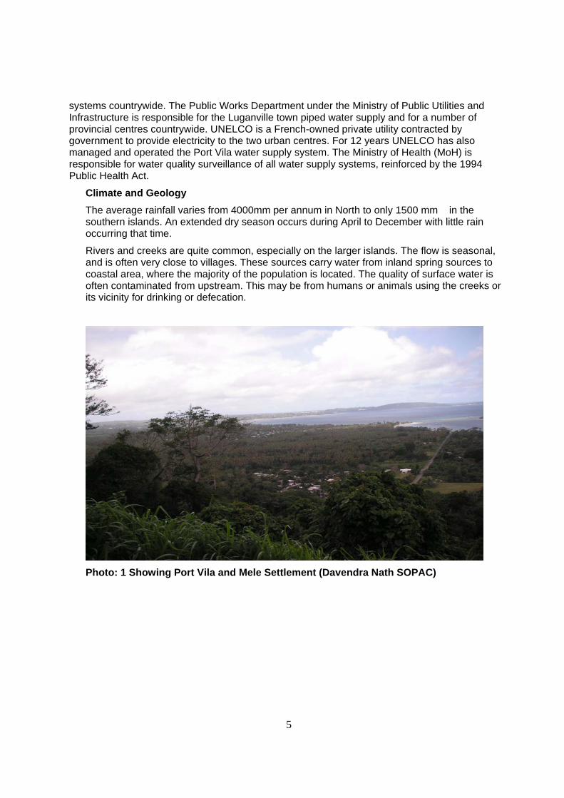
Photo: 1 Showing Port Vila and Mele Settlement (Davendra Nath SOPAC)
6
1.3 Groundwater Resources In Vanuatu both ground and surface water resources are utilised for domestic purpose. In urban areas the main water resource is groundwater whereas in rural areas various sources such as wells, springs, rivers and rain water are used. However at most places other than the main urban centre, water supply systems are either quite poor or do not exist. The quality of water is inadequate in many cases, and water sources are subject to contamination.
Ground water is that water that occurs beneath the earth’s surface. It may be abstracted from boreholes or wells, or collected from springs. Groundwater is naturally filtered by the soil or rock matrix through which it passes. Provided that the well or bore hole is located away from source of contamination, abstracted water is of very good quality. In contrast, surface water sources are more prone to bacteriological and other contamination.
In many parts of Vanuatu there are substantial amounts of water in the ground. This large amount of water provides a plentiful storage buffer to cope with seasonal variations in rainfall. If boreholes are drilled to an adequate depth, they can be expected to provide large amounts of water even during severe drought. By contrast, spring or stream sources may dry up during periods of lower rainfall.
Groundwater has traditionally been exploited by constructing hand dug wells in low lying or coastal areas. These open structures are prone to contamination and often contain water that is unsuitable for drinking. A drilled borehole capped with a pump is a better technical solution, as the groundwater source remains protected. However the drilling of a borehole requires specialised machinery that requires road excess. Generally, drilling is also restricted to where the groundwater is at a depth less than 100m below the surface.
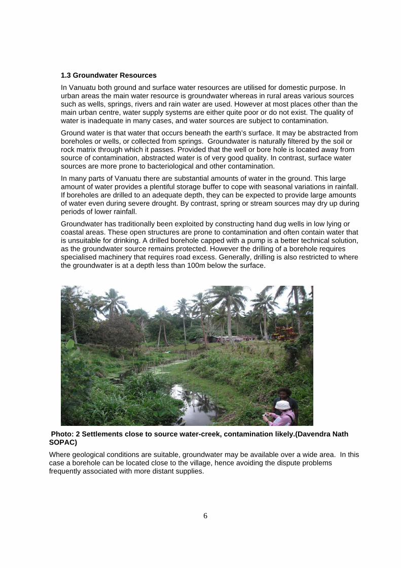
Photo: 2 Settlements close to source water-creek, contamination likely.(Davendra Nath SOPAC) Where geological conditions are suitable, groundwater may be available over a wide area. In this case a borehole can be located close to the village, hence avoiding the dispute problems frequently associated with more distant supplies.
7
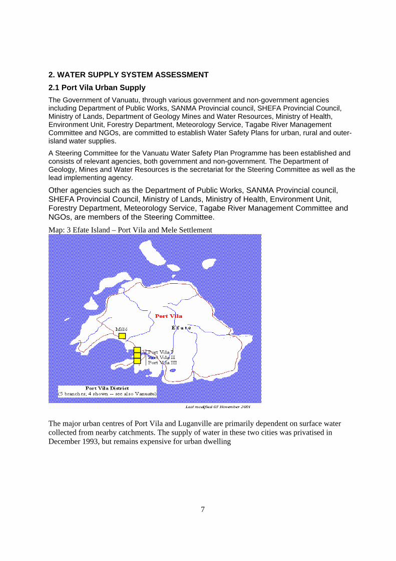
2. WATER SUPPLY SYSTEM ASSESSMENT 2.1 Port Vila Urban Supply The Government of Vanuatu, through various government and non-government agencies including Department of Public Works, SANMA Provincial council, SHEFA Provincial Council, Ministry of Lands, Department of Geology Mines and Water Resources, Ministry of Health, Environment Unit, Forestry Department, Meteorology Service, Tagabe River Management Committee and NGOs, are committed to establish Water Safety Plans for urban, rural and outer-island water supplies.
A Steering Committee for the Vanuatu Water Safety Plan Programme has been established and consists of relevant agencies, both government and non-government. The Department of Geology, Mines and Water Resources is the secretariat for the Steering Committee as well as the lead implementing agency.
Other agencies such as the Department of Public Works, SANMA Provincial council, SHEFA Provincial Council, Ministry of Lands, Ministry of Health, Environment Unit, Forestry Department, Meteorology Service, Tagabe River Management Committee and NGOs, are members of the Steering Committee. Map: 3 Efate Island – Port Vila and Mele Settlement
The major urban centres of Port Vila and Luganville are primarily dependent on surface water collected from nearby catchments. The supply of water in these two cities was privatised in December 1993, but remains expensive for urban dwelling
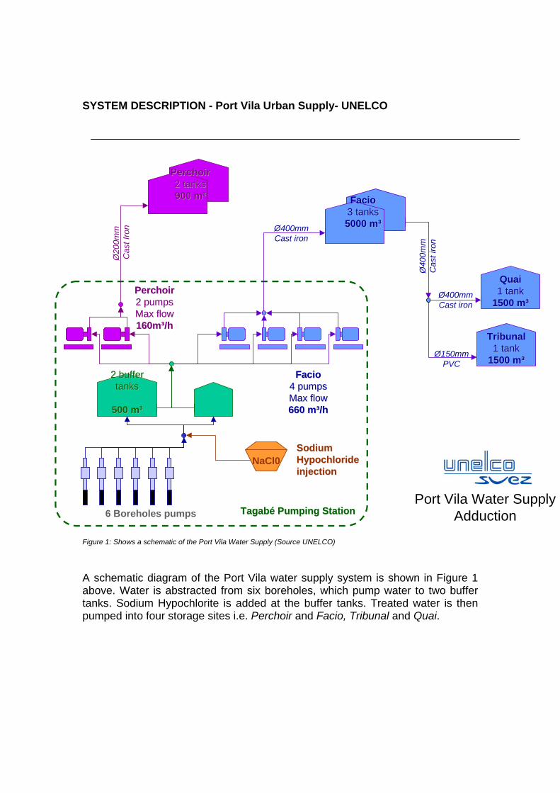
SYSTEM DESCRIPTION - Port Vila Urban Supply- UNELCO
Figure 1: Shows a schematic of the Port Vila Water Supply (Source UNELCO)
A schematic diagram of the Port Vila water supply system is shown in Figure 1 above. Water is abstracted from six boreholes, which pump water to two buffer tanks. Sodium Hypochlorite is added at the buffer tanks. Treated water is then pumped into four storage sites i.e. Perchoir and Facio, Tribunal and Quai.
Tagabé Tagabé Pumping Pumping StationStationPort Vila Water Supply
Adduction
NaCl0
6 Boreholes pumps
Sodium Sodium Hypochloride Hypochloride injectioninjection
QuaiQuai1 tank1 tank
1500 m³1500 m³
TribunalTribunal1 tank1 tank
1500 m³1500 m³
PerchoirPerchoir2 tanks2 tanks900 m³900 m³ FacioFacio
3 tanks3 tanks5000 m³5000 m³
PerchoirPerchoir2 2 pumpspumpsMax Max flowflow160m³/h160m³/h
FacioFacio4 4 pumpspumpsMax Max flowflow660 m³/h660 m³/h
2 2 buffer buffer tankstanks
500 m³500 m³
Ø20
0mm
Cas
t Iro
n Ø400mmCast iron
Ø40
0mm
Cas
t iro
n
Ø150mmPVC
Ø400mmCast iron
9
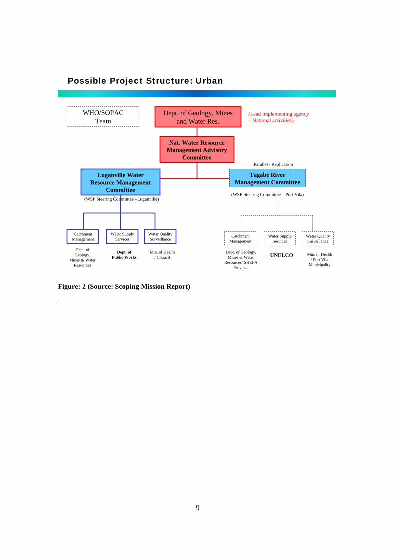
Possible Project Structure: Urban
Luganville Water Resource Management
Committee(WSP Steering Committee –Luganville)
Catchment Management
Water Supply Services
Water Quality Surveillance
Dept. of Geology,
Mines & Water Resources
Dept. of Public Works
Min. of Health / Council
Dept. of Geology, Mines and Water Res.
(Lead implementing agency – National activities)
Nat. Water Resource Management Advisory
Committee
Tagabe River Management Committee
Catchment Management
Water Supply Services
Water Quality Surveillance
Dept. of Geology, Mines & Water
Resources/ SHEFA Province
UNELCO Min. of Health / Port Vila
Municipality
(WSP Steering Committee – Port Vila)
Parallel / Replication
WHO/SOPAC Team
Figure: 2 (Source: Scoping Mission Report)
.
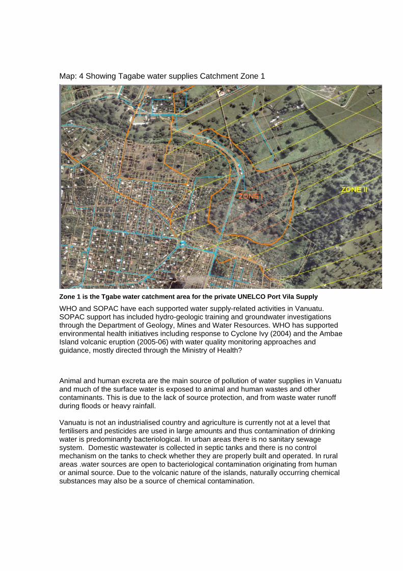
Map: 4 Showing Tagabe water supplies Catchment Zone 1
Zone 1 is the Tgabe water catchment area for the private UNELCO Port Vila Supply
WHO and SOPAC have each supported water supply-related activities in Vanuatu. SOPAC support has included hydro-geologic training and groundwater investigations through the Department of Geology, Mines and Water Resources. WHO has supported environmental health initiatives including response to Cyclone Ivy (2004) and the Ambae Island volcanic eruption (2005-06) with water quality monitoring approaches and guidance, mostly directed through the Ministry of Health?
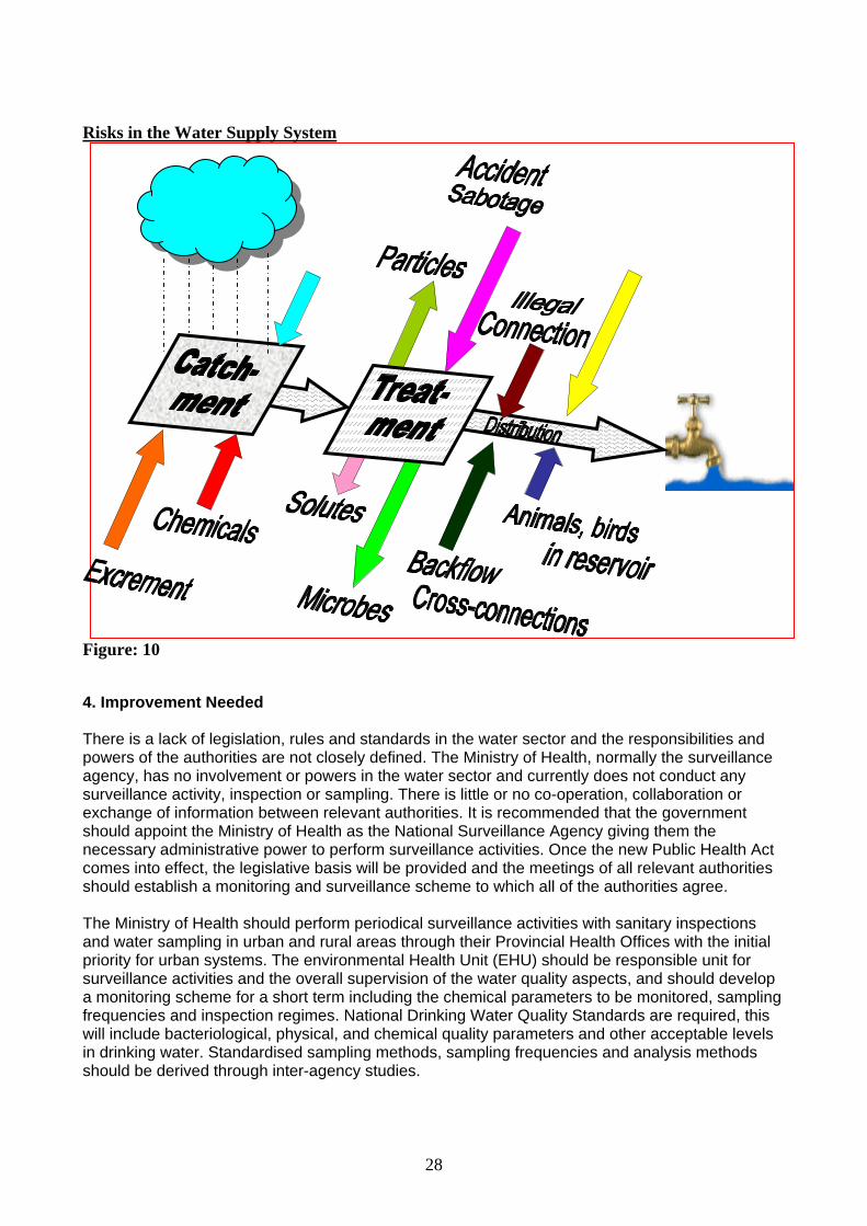
Animal and human excreta are the main source of pollution of water supplies in Vanuatu and much of the surface water is exposed to animal and human wastes and other contaminants. This is due to the lack of source protection, and from waste water runoff during floods or heavy rainfall. Vanuatu is not an industrialised country and agriculture is currently not at a level that fertilisers and pesticides are used in large amounts and thus contamination of drinking water is predominantly bacteriological. In urban areas there is no sanitary sewage system. Domestic wastewater is collected in septic tanks and there is no control mechanism on the tanks to check whether they are properly built and operated. In rural areas .water sources are open to bacteriological contamination originating from human or animal source. Due to the volcanic nature of the islands, naturally occurring chemical substances may also be a source of chemical contamination.
11
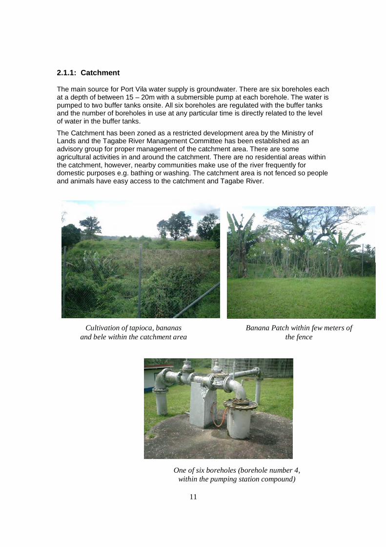
2.1.1: Catchment
The main source for Port Vila water supply is groundwater. There are six boreholes each at a depth of between 15 – 20m with a submersible pump at each borehole. The water is pumped to two buffer tanks onsite. All six boreholes are regulated with the buffer tanks and the number of boreholes in use at any particular time is directly related to the level of water in the buffer tanks.
The Catchment has been zoned as a restricted development area by the Ministry of Lands and the Tagabe River Management Committee has been established as an advisory group for proper management of the catchment area. There are some agricultural activities in and around the catchment. There are no residential areas within the catchment, however, nearby communities make use of the river frequently for domestic purposes e.g. bathing or washing. The catchment area is not fenced so people and animals have easy access to the catchment and Tagabe River.
Cultivation of tapioca, bananas and bele within the catchment area
Banana Patch within few meters of the fence
One of six boreholes (borehole number 4, within the pumping station compound)
12
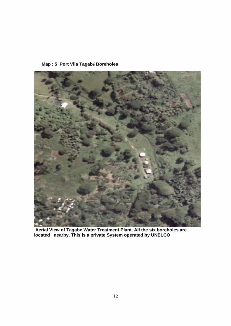
Map : 5 Port Vila Tagabé Boreholes
Aerial View of Tagabe Water Treatment Plant. All the six boreholes are located nearby. This is a private System operated by UNELCO
13
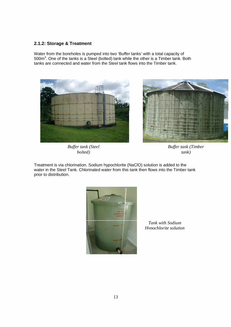
2.1.2: Storage & Treatment
Water from the boreholes is pumped into two ‘Buffer tanks’ with a total capacity of 500m3. One of the tanks is a Steel (bolted) tank while the other is a Timber tank. Both tanks are connected and water from the Steel tank flows into the Timber tank.
Treatment is via chlorination. Sodium hypochlorite (NaClO) solution is added to the water in the Steel Tank. Chlorinated water from this tank then flows into the Timber tank prior to distribution.
Buffer tank (Steel bolted)
Buffer tank (Timber tank)
Tank with Sodium Hypochlorite solution
14
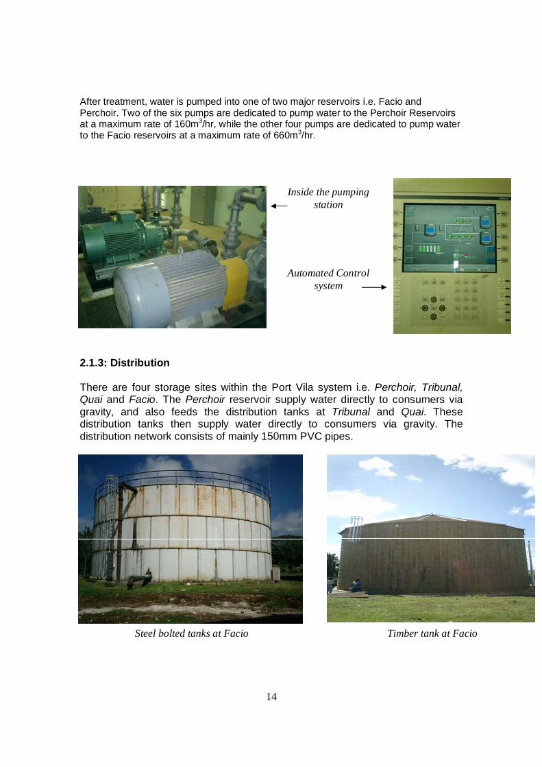
After treatment, water is pumped into one of two major reservoirs i.e. Facio and Perchoir. Two of the six pumps are dedicated to pump water to the Perchoir Reservoirs at a maximum rate of 160m3/hr, while the other four pumps are dedicated to pump water to the Facio reservoirs at a maximum rate of 660m3/hr.
2.1.3: Distribution There are four storage sites within the Port Vila system i.e. Perchoir, Tribunal, Quai and Facio. The Perchoir reservoir supply water directly to consumers via gravity, and also feeds the distribution tanks at Tribunal and Quai. These distribution tanks then supply water directly to consumers via gravity. The distribution network consists of mainly 150mm PVC pipes.
Inside the pumping station
Automated Control system
Steel bolted tanks at Facio Timber tank at Facio
15
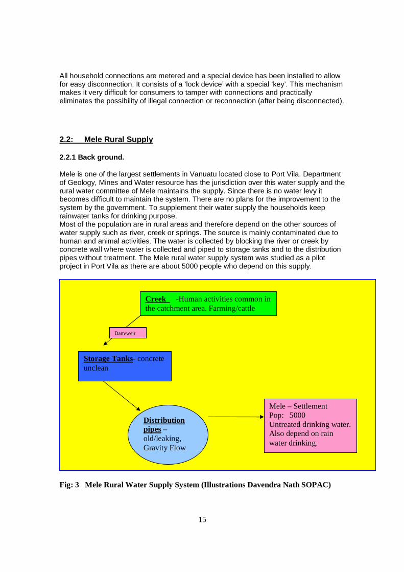
All household connections are metered and a special device has been installed to allow for easy disconnection. It consists of a ‘lock device’ with a special ‘key’. This mechanism makes it very difficult for consumers to tamper with connections and practically eliminates the possibility of illegal connection or reconnection (after being disconnected). 2.2: Mele Rural Supply 2.2.1 Back ground. Mele is one of the largest settlements in Vanuatu located close to Port Vila. Department of Geology, Mines and Water resource has the jurisdiction over this water supply and the rural water committee of Mele maintains the supply. Since there is no water levy it becomes difficult to maintain the system. There are no plans for the improvement to the system by the government. To supplement their water supply the households keep rainwater tanks for drinking purpose. Most of the population are in rural areas and therefore depend on the other sources of water supply such as river, creek or springs. The source is mainly contaminated due to human and animal activities. The water is collected by blocking the river or creek by concrete wall where water is collected and piped to storage tanks and to the distribution pipes without treatment. The Mele rural water supply system was studied as a pilot project in Port Vila as there are about 5000 people who depend on this supply.
Fig: 3 Mele Rural Water Supply System (Illustrations Davendra Nath SOPAC)
Creek -Human activities common in the catchment area. Farming/cattle
Storage Tanks- concrete unclean
Distribution pipes –old/leaking, Gravity Flow
Mele – Settlement Pop: 5000 Untreated drinking water. Also depend on rain water drinking.
Dam/weir
16
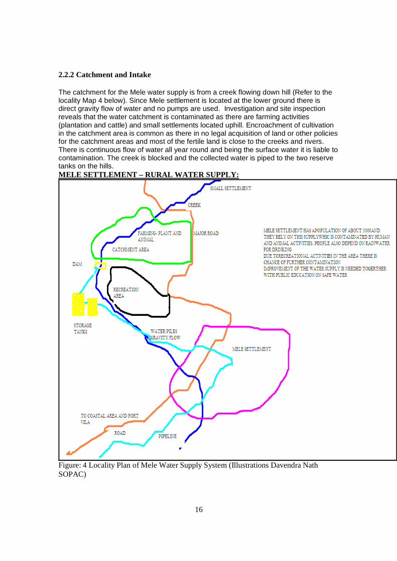
2.2.2 Catchment and Intake The catchment for the Mele water supply is from a creek flowing down hill (Refer to the locality Map 4 below). Since Mele settlement is located at the lower ground there is direct gravity flow of water and no pumps are used. Investigation and site inspection reveals that the water catchment is contaminated as there are farming activities (plantation and cattle) and small settlements located uphill. Encroachment of cultivation in the catchment area is common as there in no legal acquisition of land or other policies for the catchment areas and most of the fertile land is close to the creeks and rivers. There is continuous flow of water all year round and being the surface water it is liable to contamination. The creek is blocked and the collected water is piped to the two reserve tanks on the hills. MELE SETTLEMENT – RURAL WATER SUPPLY:
Figure: 4 Locality Plan of Mele Water Supply System (Illustrations Davendra Nath SOPAC)
17
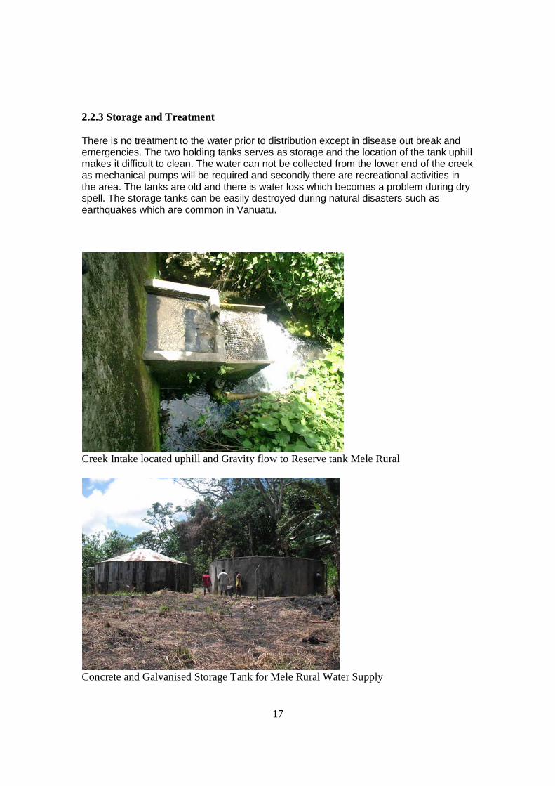
2.2.3 Storage and Treatment There is no treatment to the water prior to distribution except in disease out break and emergencies. The two holding tanks serves as storage and the location of the tank uphill makes it difficult to clean. The water can not be collected from the lower end of the creek as mechanical pumps will be required and secondly there are recreational activities in the area. The tanks are old and there is water loss which becomes a problem during dry spell. The storage tanks can be easily destroyed during natural disasters such as earthquakes which are common in Vanuatu.
Creek Intake located uphill and Gravity flow to Reserve tank Mele Rural
Concrete and Galvanised Storage Tank for Mele Rural Water Supply
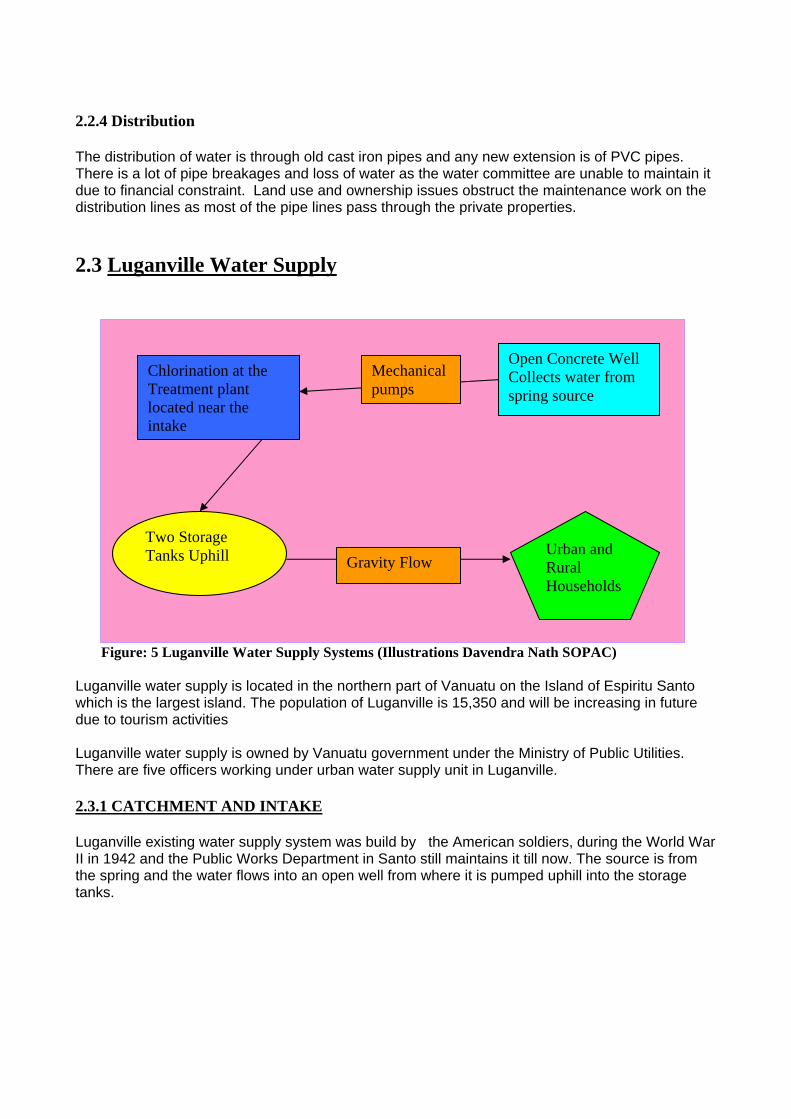
2.2.4 Distribution The distribution of water is through old cast iron pipes and any new extension is of PVC pipes. There is a lot of pipe breakages and loss of water as the water committee are unable to maintain it due to financial constraint. Land use and ownership issues obstruct the maintenance work on the distribution lines as most of the pipe lines pass through the private properties. 2.3 Luganville Water Supply Figure: 5 Luganville Water Supply Systems (Illustrations Davendra Nath SOPAC) Luganville water supply is located in the northern part of Vanuatu on the Island of Espiritu Santo which is the largest island. The population of Luganville is 15,350 and will be increasing in future due to tourism activities Luganville water supply is owned by Vanuatu government under the Ministry of Public Utilities. There are five officers working under urban water supply unit in Luganville. 2.3.1 CATCHMENT AND INTAKE Luganville existing water supply system was build by the American soldiers, during the World War II in 1942 and the Public Works Department in Santo still maintains it till now. The source is from the spring and the water flows into an open well from where it is pumped uphill into the storage tanks.
Open Concrete Well Collects water from spring source
Two Storage Tanks Uphill
Chlorination at the Treatment plant located near the intake
Urban and Rural Households
Mechanical pumps
Gravity Flow
19
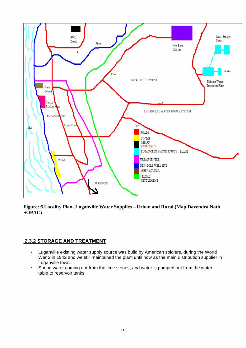
Figure: 6 Locality Plan- Luganville Water Supplies – Urban and Rural (Map Davendra Nath SOPAC) 2.3.2 STORAGE AND TREATMENT
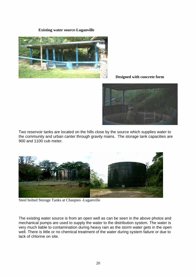
• Luganville existing water supply source was build by American soldiers, during the World War 2 in 1942 and we still maintained the plant until now as the main distribution supplier in Luganville town.
• Spring water coming out from the lime stones, and water is pumped out from the water table to reservoir tanks.
20
Existing water source-Luganville
Designed with concrete form
Two reservoir tanks are located on the hills close by the source which supplies water to the community and urban canter through gravity mains. The storage tank capacities are 900 and 1100 cub meter.
Steel bolted Storage Tanks at Chaupies -Luganville The existing water source is from an open well as can be seen in the above photos and mechanical pumps are used to supply the water to the distribution system. The water is very much liable to contamination during heavy rain as the storm water gets in the open well. There is little or no chemical treatment of the water during system failure or due to lack of chlorine on site.
21
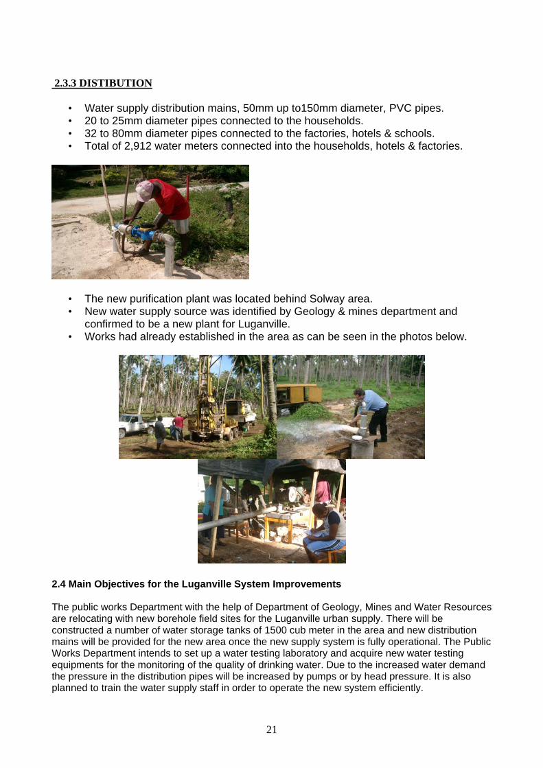
2.3.3 DISTIBUTION
• Water supply distribution mains, 50mm up to150mm diameter, PVC pipes. • 20 to 25mm diameter pipes connected to the households. • 32 to 80mm diameter pipes connected to the factories, hotels & schools. • Total of 2,912 water meters connected into the households, hotels & factories.
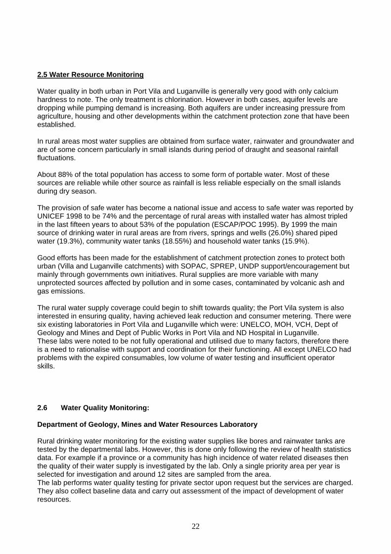
• The new purification plant was located behind Solway area. • New water supply source was identified by Geology & mines department and
confirmed to be a new plant for Luganville. • Works had already established in the area as can be seen in the photos below.
2.4 Main Objectives for the Luganville System Improvements The public works Department with the help of Department of Geology, Mines and Water Resources are relocating with new borehole field sites for the Luganville urban supply. There will be constructed a number of water storage tanks of 1500 cub meter in the area and new distribution mains will be provided for the new area once the new supply system is fully operational. The Public Works Department intends to set up a water testing laboratory and acquire new water testing equipments for the monitoring of the quality of drinking water. Due to the increased water demand the pressure in the distribution pipes will be increased by pumps or by head pressure. It is also planned to train the water supply staff in order to operate the new system efficiently.
22
2.5 Water Resource Monitoring Water quality in both urban in Port Vila and Luganville is generally very good with only calcium hardness to note. The only treatment is chlorination. However in both cases, aquifer levels are dropping while pumping demand is increasing. Both aquifers are under increasing pressure from agriculture, housing and other developments within the catchment protection zone that have been established. In rural areas most water supplies are obtained from surface water, rainwater and groundwater and are of some concern particularly in small islands during period of draught and seasonal rainfall fluctuations. About 88% of the total population has access to some form of portable water. Most of these sources are reliable while other source as rainfall is less reliable especially on the small islands during dry season. The provision of safe water has become a national issue and access to safe water was reported by UNICEF 1998 to be 74% and the percentage of rural areas with installed water has almost tripled in the last fifteen years to about 53% of the population (ESCAP/POC 1995). By 1999 the main source of drinking water in rural areas are from rivers, springs and wells (26.0%) shared piped water (19.3%), community water tanks (18.55%) and household water tanks (15.9%). Good efforts has been made for the establishment of catchment protection zones to protect both urban (Villa and Luganville catchments) with SOPAC, SPREP, UNDP support/encouragement but mainly through governments own initiatives. Rural supplies are more variable with many unprotected sources affected by pollution and in some cases, contaminated by volcanic ash and gas emissions. The rural water supply coverage could begin to shift towards quality; the Port Vila system is also interested in ensuring quality, having achieved leak reduction and consumer metering. There were six existing laboratories in Port Vila and Luganville which were: UNELCO, MOH, VCH, Dept of Geology and Mines and Dept of Public Works in Port Vila and ND Hospital in Luganville. These labs were noted to be not fully operational and utilised due to many factors, therefore there is a need to rationalise with support and coordination for their functioning. All except UNELCO had problems with the expired consumables, low volume of water testing and insufficient operator skills. 2.6 Water Quality Monitoring: Department of Geology, Mines and Water Resources Laboratory Rural drinking water monitoring for the existing water supplies like bores and rainwater tanks are tested by the departmental labs. However, this is done only following the review of health statistics data. For example if a province or a community has high incidence of water related diseases then the quality of their water supply is investigated by the lab. Only a single priority area per year is selected for investigation and around 12 sites are sampled from the area. The lab performs water quality testing for private sector upon request but the services are charged. They also collect baseline data and carry out assessment of the impact of development of water resources.

23
Currently the Dept of GMWR lab is analysing samples for total coliform and E-coli. The microbiologist testing is done in the lab at Port Vila and onsite for the outer islands. The lab has a portable incubator which it uses for the outer island analysis. Physical parameters are also tested for and these include temperature, EC, DO, depth, salinity ORP and TDS. The physical tests are all performed by using the Quanta hydro lab multi probe meter. UNELCO Laboratory: UNELCO is a private company contracted by the Vanuatu Government for supplying water to the urban area of Port Vila. Basically, the supply system consists of six bores from which water is extracted. Depending on the water demand 3- 6 bore pumps could be functioning at one time. The water level inside the distribution tanks are monitored automatically and a decline in the level would trigger the pumps to activate, also automatically. From the bores the water is pumped into a contact tank where chorine is added. The dosing injection is electronic. However, as liquid chlorine is added the chlorine tanks need to be monitored and filled manually. The chlorine contact time in the tank is seven hours after which it is pumped to the distribution tanks. Just after the contact tank, the level of chlorine is tested to maintain a residual chlorine level of 0.2-0.3mg/l. the average pH value of the source bore water ranges between 7.0- 7.5 with a total hardness value of 4000mg/l. Public Works Department Lab: The Public Works Department (PWD) supplies water to the five provincial headquarters except Port Vila around Vanuatu of which the major one is Luganville. The water supply sources include rivers and ground water but at the moment the only area they treat water via the use of chlorine is in Luganville. They have also installed two new pumps in the Malampa province but they are not operational currently. At the moment there is no water testing been performed in the laboratory? The Northern District Hospital Lab at the moment does not analyse any kind of environmental samples including water, they only do bacterial identification for blood sampling. Steven Iddings from WHO informed that in 2004 he supplied three Trawas Bacteriological kits to Vanuatu for water testing and one was supplied to Luganville Environmental Health Officer. It was revealed that the kit was not used due to expired consumables. At the Ministry of Health Lab in Port Vila there is no water quality testing being performed at the moment. The MoH has recently moved offices hence they do not have a lab space to do the testing. Even when the lab was operating there was no proper monitoring programme being followed. It was informed that analysis of samples was only done upon consumer complaints and the test only included bacteriological analysis using the Trawas kit. The Vila Central Hospital Lab does not perform any water quality testing at the moment. They only do bacterial identification of blood and stools. Previously they used to have a Public Health water lab where they performed microbiological testing on water samples for total coliform, faecal coliform and E.Coli. The analysis was done when Health Officers brought in samples upon public complaints on water quality or pollution. The lab eventually closed at the end of 2003 because the Dept of Geology Mines built their capacity of water testing.
24
3. WATER SAFETY PLANNING Water Safety Plans (WSP) is the nameplate for WHO’s new risk-assessment / risk-management approach to ensuring safe drinking water. This approach was introduced to Pacific island countries (PICs) in a February 2005 workshop in Nadi, Fiji. That gathering of 18 countries and territories also completed a ‘Framework for Action on Drinking Water Quality and Health in Pacific Island Countries’ to guide future activities and gather donor support. The meeting of Pacific Islands Health Ministers in Apia, Samoa, endorsed this ‘Framework’ two months later with a statement in the ‘Samoa Commitment’. Three Pacific-wide water quality programmes have since been proposed and funded.
The ‘Pacific Water Safety Plans Programme’ began in late 2005 under AusAID funding to SOPAC and WHO. This two-year joint programme will pilot Water Safety Plans in at least four PICs. Vanuatu was among the four PICs selected according to the programme’s selection criteria and is the only Melanesian country of the four.
This WHO/SOPAC scoping mission was proposed to determine the scope and interest and secure the commitment of key government counterparts including the Ministry of Lands and Natural Resources (MLNR), the Ministry of Health (MoH), the Ministry of Infrastructure and Public Utilities and other potential partners including NGO’s. The MLNR applied to WHO/SOPAC for support under the Pacific WSP Programme and requested the scoping mission.
There is strong interest from key authorities such as Dept of Geology Mines and Water Works, Ministry of Health ,Dept of Public Health to work together to establish WSP pilots in Port Vila and Luganville.
The existing National Water Resource Management Advisory Committee could take on the responsibilities of the WSP National steering committee as it is essentially the right composition of the stakeholders and has the authority. The work done by the Tagabe River Management Committee on catchment management and zoning plans could be built on by a Port Vila WSP. There is a good scope for WSP approach in Port Vila and Luganville for both rural and urban systems.
25
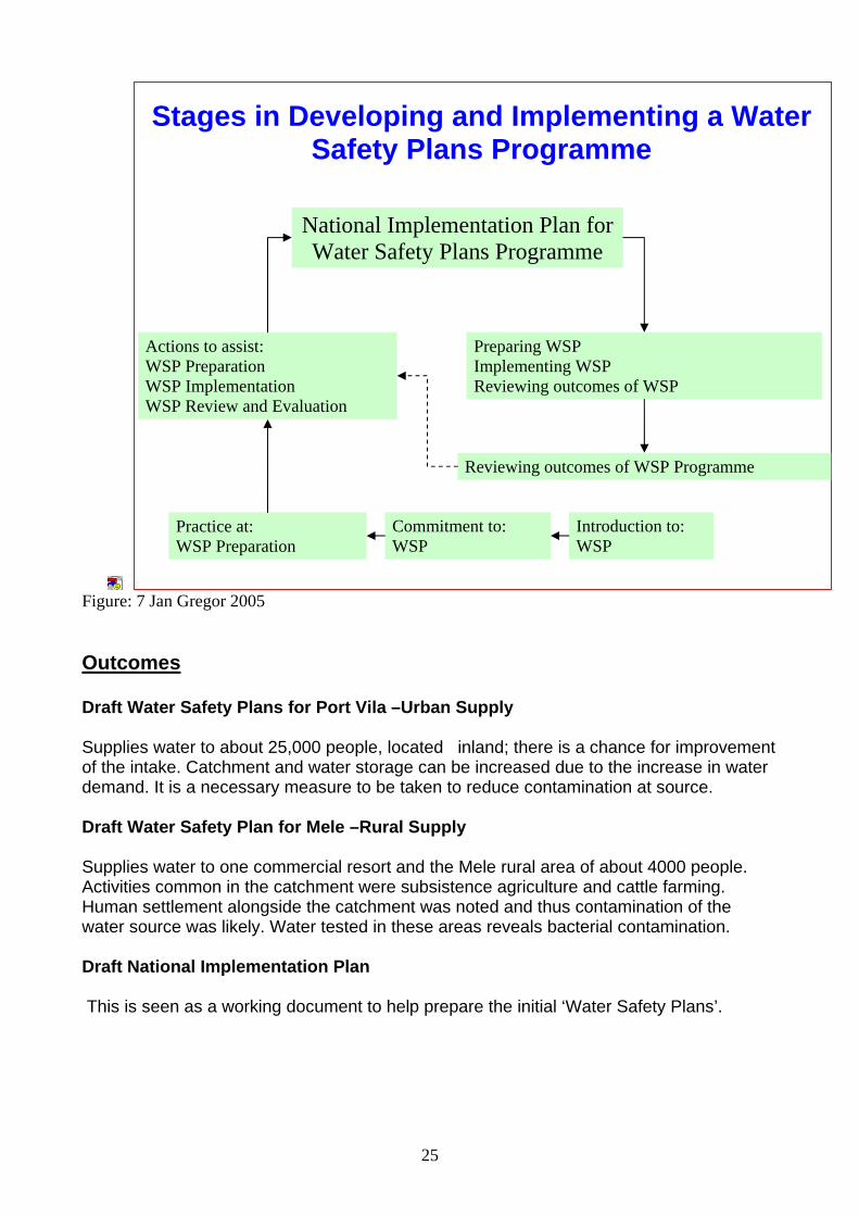
Figure: 7 Jan Gregor 2005 Outcomes Draft Water Safety Plans for Port Vila –Urban Supply Supplies water to about 25,000 people, located inland; there is a chance for improvement of the intake. Catchment and water storage can be increased due to the increase in water demand. It is a necessary measure to be taken to reduce contamination at source. Draft Water Safety Plan for Mele –Rural Supply Supplies water to one commercial resort and the Mele rural area of about 4000 people. Activities common in the catchment were subsistence agriculture and cattle farming. Human settlement alongside the catchment was noted and thus contamination of the water source was likely. Water tested in these areas reveals bacterial contamination. Draft National Implementation Plan This is seen as a working document to help prepare the initial ‘Water Safety Plans’.
National Implementation Plan for Water Safety Plans Programme
Actions to assist: WSP Preparation WSP Implementation WSP Review and Evaluation
Preparing WSP Implementing WSP Reviewing outcomes of WSP
Practice at: WSP Preparation
Commitment to: WSP
Stages in Developing and Implementing a Water Safety Plans Programme
Introduction to: WSP
Reviewing outcomes of WSP Programme
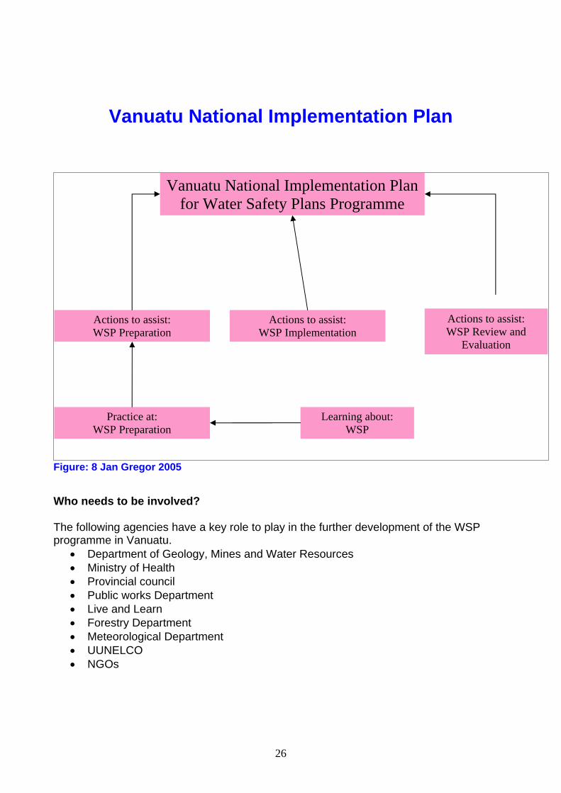
26
Vanuatu National Implementation Plan
Figure: 8 Jan Gregor 2005
Who needs to be involved? The following agencies have a key role to play in the further development of the WSP programme in Vanuatu.
• Department of Geology, Mines and Water Resources • Ministry of Health • Provincial council • Public works Department • Live and Learn • Forestry Department • Meteorological Department • UUNELCO • NGOs
Vanuatu National Implementation Plan for Water Safety Plans Programme
Actions to assist: WSP Preparation
Actions to assist: WSP Implementation
Practice at: WSP Preparation
Learning about: WSP
Actions to assist: WSP Review and
Evaluation
27
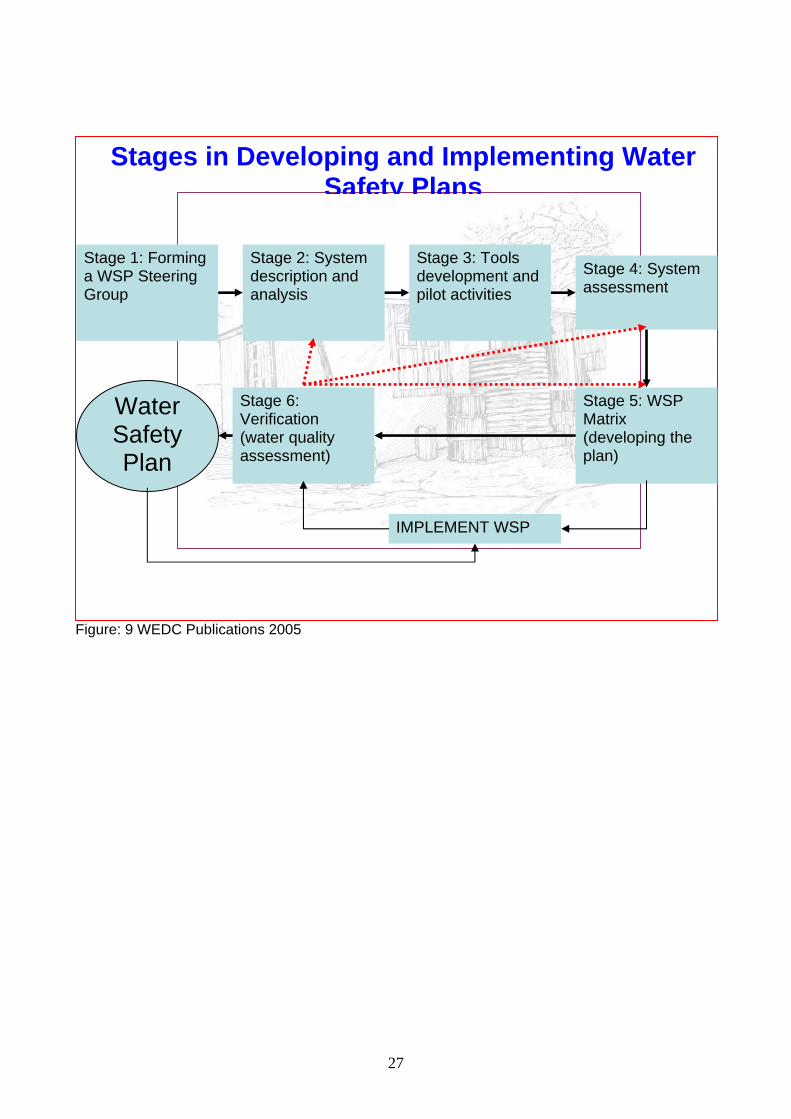
Figure: 9 WEDC Publications 2005
Stages in Developing and Implementing Water Safety Plans
Stage 1: Forming a WSP Steering Group
Stage 2: System description and analysis
Stage 3: Tools development and pilot activities
Stage 4: System assessment
Stage 5: WSP Matrix (developing the plan)
Stage 6: Verification (water quality assessment)
Water Safety Plan
IMPLEMENT WSP
28
Risks in the Water Supply System
Figure: 10
4. Improvement Needed There is a lack of legislation, rules and standards in the water sector and the responsibilities and powers of the authorities are not closely defined. The Ministry of Health, normally the surveillance agency, has no involvement or powers in the water sector and currently does not conduct any surveillance activity, inspection or sampling. There is little or no co-operation, collaboration or exchange of information between relevant authorities. It is recommended that the government should appoint the Ministry of Health as the National Surveillance Agency giving them the necessary administrative power to perform surveillance activities. Once the new Public Health Act comes into effect, the legislative basis will be provided and the meetings of all relevant authorities should establish a monitoring and surveillance scheme to which all of the authorities agree. The Ministry of Health should perform periodical surveillance activities with sanitary inspections and water sampling in urban and rural areas through their Provincial Health Offices with the initial priority for urban systems. The environmental Health Unit (EHU) should be responsible unit for surveillance activities and the overall supervision of the water quality aspects, and should develop a monitoring scheme for a short term including the chemical parameters to be monitored, sampling frequencies and inspection regimes. National Drinking Water Quality Standards are required, this will include bacteriological, physical, and chemical quality parameters and other acceptable levels in drinking water. Standardised sampling methods, sampling frequencies and analysis methods should be derived through inter-agency studies.
29
5. Conclusion The Port Vila supply is satisfactory as it is owned by a private company UNELCO, whereas treatment and distributions are maintained well the catchment system at Tagabe needs improvement. Similarly much improvement is needed for Luganville and Mele water supply systems. Water quality in both urban centres of Port Vila and Luganville is generally very good with only calcium hardness to note. Neither currently requires treatment other than chlorination to eliminate bacterial contamination. However in both cases aquifer levels are thought to be decreasing while pumping demands are slightly increasing. It is very necessary to relocate the treatment plant at Luganville to the new bore well site to meet the water demand. Both aquifers are under increasing pressure from agriculture, housing and other developments within the catchment protection zones that have been established. The protection zones are the result of very good efforts to protect these catchments. It is anticipated that Department of Geology Mines and Water Resources, the Ministry of Health and the Department of Public Works to work together to establish Water Safety Plans Pilots. Cooperation of all these agencies is necessary as they also expressed interest towards this programme.
6. References
1. United Nations Common Country Assessment, Vanuatu-Office of the United Nations Resident Coordinator Suva, Fiji ,May 2002
2. Country Report Vanuatu, by Mr. Viram Tovu, Senior Environmental, Health Officer, Ministry of Health, Port Vila, Ms Rosette Kalmet, Hydro-geologist, Department of Geology, Mines and Water Resources. Port Vila, Workshop on Drinking Water Quality Surveillance and Safety- 29/10 to 1/11/2001, Nadi Fiji.
3. Development of Drinking Water Quality Monitoring and Surveillance in the Philippines, Papua New Guinea, Tonga and Vanuatu –Report 2 Vanuatu May- October 2002 by Hulya Aras ,Environmental Engineer
4. Country report –Vanuatu –Workshop on Drinking Water Quality Standards and Monitoring in Pacific Island Countries, Nadi, Fiji 7-10 February 2005.
5. SOPAC/WHO Country Scoping Mission report 2006, Water Safety Plans Programme
6. SOPAC/WHO Country Workshop Report, 2006, Water Safety Plans Programme. 7. Water Safety Plans- Planning Water Safety Management for urban water supplies
in developing countries; Godfrey.S; Howard, G; 2005. 8. Water Safety Planning in Practice-whose plan it; paper presented during the Water
Safety Plans Workshop, Suva Fiji .Gregor J, et.al 2005 Suva Fiji. 9. WHO Guidelines for Drinking Quality, 2004 Volume 1 ,Third Edition 10. Small Drinking- Water Supplies, Preparing a public health risk management plan,
Ministry of Health 2005, Wellington.