water security in the middle east - transboundary freshwater
TRANSCRIPT

WATER SECURITY IN THE MIDDLE EAST
GROWING CONFLICT OVER DEVELOPMENT IN THE EUPHRATES-
TIGRIS BASIN
By: Patrick MacQuarrie
Revised: 26 February 2004
Originally submitted 15 September 2003
Thesis, M.Phil International Peace Studies
Trinity College, Dublin, Ireland

ii
���������
WATER SECURITY IN THE MIDDLE EAST: Growing Conflict over Development in the Euphrates-Tigris Basin.
By: Patrick MacQuarrie
Date: 26 February 2004
Water security of riparian states in the Euphrates-Tigris Basin is increasingly under threat. Continuing conflict over the allocation of water is failing to produce a tripartite agreement between Turkey, Syria and Iraq. Massive hydrodevelopment in southern Turkey threatens to reduce Syrian water on the Euphrates by over 40 percent, and Iraqi water by over 80 percent. After reviewing hydrology in the Euphrates-Tigris Basin, Chapter II gives an analysis of the factors affecting Turkey’s water security, outlining the GAP project, Kurdish issue and Turkey’s political aspirations. Chapter III addresses water security for Syria and Iraq and accounts for recent conflicts over water usage. Particular attention is given to Syria and Iraq’s historic rights, irrigation projects, dependence on agriculture and relationship with Kurdistan. Finally, Chapter IV looks at the relationship between water scarcity, expanding resource security and ethical river use, followed by an account of failed attempts at cooperation between riparians and the application of international watercourse law. The research suggests resource security is increasingly political and faces increased threats in the next forty years. Perspectives towards an ethical basin-wide management plan end the thesis in the overall conclusions.

iii
����������������
Abstract _________________________________________________________________ii Table of Contents: ____________________________________________________________iii
List of Maps:_________________________________________________________________iv
List of Tables:________________________________________________________________iv
List of Figures: _______________________________________________________________ v
Introduction ___________________________________________________________ - 1 -
CHAPTER I: Geography and Climate of the Euphrates-Tigris Basin_____________ - 3 -
CHAPTER II: Turkey, Water and Security. _________________________________ - 9 - Turkey’s pro-development policy and national image _____________________________ - 9 -
Priorities for Water Use in Turkey_____________________________________________________ - 9 - Energy Concerns _________________________________________________________________ - 10 - The Southeast Anatolia Development Project (GAP) _____________________________________ - 11 -
History and Influences___________________________________________________________ - 11 - Objectives and Technical Details __________________________________________________ - 13 - Regional Development of Southern Anatolia_________________________________________ - 17 -
Security in the South – The Kurdish Issue _____________________________________________ - 17 - Turkey’s image – National Integrity and Financial Constraints _____________________________ - 22 - Military Security and Links to Water _________________________________________________ - 26 -
Chapter II Conclusions _____________________________________________________ - 26 -
CHAPTER III: Water Security for Downstream Riparians on the Euphrates and Tigris - 28 -
Water Security for Syria ____________________________________________________ - 28 - Pressure to Maintain an Agrarian Based Economy_______________________________________ - 28 - Syria’s Water Imperative: The Euphrates Valley Project __________________________________ - 31 - Political Tensions and Historical Rivalries _____________________________________________ - 34 -
Syria and the PKK ______________________________________________________________ - 34 - The ‘Stolen’ Province of Hatay____________________________________________________ - 36 -
Iraq and Water Security ____________________________________________________ - 38 - Ancient Mesopotamia and the Hydraulic Culture ________________________________________ - 38 - Priorities Over Land and Water Quality _______________________________________________ - 40 -
Water Quality _________________________________________________________________ - 41 - Iraq’s Water Resources ____________________________________________________________ - 41 -
Recent Water Works in Iraq ______________________________________________________ - 43 - Iraqi Water Withdrawals ___________________________________________________________ - 44 - Agriculture and Food Security in Iraq _________________________________________________ - 46 - Iraq’s Economy and Relations with the International Community___________________________ - 47 -
Food Production and Nutrition ____________________________________________________ - 47 - Ba’ath Party Rivalry with Syria______________________________________________________ - 48 -
Threats to Downstream Riparians Due to Upstream Development _________________ - 49 - Impounding at Turkey’s Keban Reservoir and Syria’s Lake Assad__________________________ - 49 - The Filling Atatürk Reservoir – Agreements verses Downstream Effects_____________________ - 50 -
Chapter III Conclusions ____________________________________________________ - 54 -

iv
CHAPTER IV: Scarcity and Security: Implications for Management of the Euphrates-Tigris Basin __________________________________________________________ - 55 -
Regional Scarcity in the Middle East __________________________________________ - 55 -
Water-Related Conflict and the Expansion of Traditional Security_________________ - 58 - Environmental Security and a River Ethic to Support Sustainable Development _______________ - 60 -
Attempted Agreements between Co-Riparians__________________________________ - 61 - Inert Treaties_____________________________________________________________________ - 61 - The Joint Technical Committee (JTC)_________________________________________________ - 62 - Bilateral Attempts at Water Sharing __________________________________________________ - 63 -
Water Management Policy via International Law _______________________________ - 64 - Historic Water Law in the Middle East ________________________________________________ - 64 - Contemporary International Water Law _______________________________________________ - 64 -
Harmon Doctrine (absolute territorial sovereignty) ____________________________________ - 66 - Absolute territorial integrity (existing lower riparian rights first) _________________________ - 66 - Equitable and reasonable utilization (UN/ILC Law) ___________________________________ - 67 -
UN Law of Non-Navigational Uses of International Watercourses Convention — Application to the Euphrates-Tigris Basin_____________________________________________________________ - 67 -
Outlook for Cooperation – Conclusions____________________________________ - 70 -
Bibliography _________________________________________________________ - 72 -
� ������������
FIGURE 1: Water Resources in Turkey______________________________________________________ - 10 - FIGURE 2: Devaluation of Turkish Lira (TL to US $) __________________________________________ - 25 - FIGURE 3: Share of Public Spending on GAP ________________________________________________ - 25 - FIGURE 4: Population Trends for Syria _____________________________________________________ - 29 - FIGURE 5: Agricultural Import/Export History for Syria _______________________________________ - 30 - FIGURE 6: Land Use in Syria. ____________________________________________________________ - 32 - FIGURE 7: Iraqi Water Supply (various yrs to date) ___________________________________________ - 43 - FIGURE 8: Iraqi Water Balance 1990, 2040 (bcm) ____________________________________________ - 46 - FIGURE 9: Calorie Intake per Capita for Turkey, Syria and Iraq_________________________________ - 48 - FIGURE 10: Water use per capita for Turkey, Syria and Iraq____________________________________ - 56 -
� ��������������
TABLE 1: Riparian Contributions to the Euphrates-Tigris Basin __________________________________ - 6 - TABLE 2: Riparian Contribution to the Euphrates River Basin ___________________________________ - 7 - TABLE 3: Riparian Contribution to the Tigris River Basin _______________________________________ - 7 - TABLE 4: Equitable Use Relative Ranking for Euphrates-Tigris Basin ____________________________ - 68 - TABLE 5: Water Security - Relative Ranking _________________________________________________ - 68 -

v
� ������� �������
FIGURE 1: Water Resources in Turkey______________________________________________________ - 10 - FIGURE 2: Devaluation of Turkish Lira (TL to US $) __________________________________________ - 25 - FIGURE 3: Share of Public Spending on GAP ________________________________________________ - 25 - FIGURE 4: Population Trends for Syria _____________________________________________________ - 29 - FIGURE 5: Agricultural Import/Export History for Syria _______________________________________ - 30 - FIGURE 6: Land Use in Syria. ____________________________________________________________ - 32 - FIGURE 7: Iraqi Water Supply (various yrs to date) ___________________________________________ - 43 - FIGURE 8: Iraqi Water Balance 1990, 2040 (bcm) ____________________________________________ - 46 - FIGURE 9: Calorie Intake per Capita for Turkey, Syria and Iraq_________________________________ - 48 - FIGURE 10: Water use per capita for Turkey, Syria and Iraq____________________________________ - 56 -

- 1 -
���������
The region of the Middle East where humans settled some 10 millennia ago is known as the Fertile Crescent. In the upper Fertile Crescent, two mighty rivers, the Euphrates and Tigris, make their beginnings, in the present state of Turkey, winding their way down through Syria and eventually Iraq, where they have irrigated the Mesopotamian Plain for over six-thousand years. In this region, the Cradle of Civilisation, site of the Garden of Eden, water has been the source of life, probably pre-existing it, and the cause of conflict.
Modern states taking shape in the twentieth century have reformed political and territorial boundaries, partitioning Euphrates and Tigris river water between Turkey, Syria and Iraq. Recent development plans by Turkey threaten to deny water historically utilized by downstream riparians, Syria and Iraq. Water scarcity in the Middle East, the recent emergence of developing states and historic political rivalries threaten riparians with conflict. As a result, the three states have sought to securitize their rights over Euphrates and Tigris water.
The following thesis defends the argument that riparian states on the Euphrates and Tigris have widened their respective conventional security concerns to include water, creating a hydropolitical security complex in the region. It argues that political, national and international security, particularly in the case of Turkey, has been the basic determinant for water policy and development. I also assert that water security for downstream riparians, Syria and Iraq, is primarily centred on irrigation, food security and established rights, all inherently inefficient methods of water use. Due to the politicising of water resources, states have pursued unilateral and unsustainable development objectives, rejected international water law, and failed to reach a tripartite agreement to share water in the basin.
Chapter I gives a brief geological and hydrographic background of the Euphrates and Tigris Rivers, illuminating their diverse character and apportioning figures for discharge, drainage area and river length between Turkey, Syria and Iraq.
Chapter II analyses water security in Turkey with focus given to Turkey’s hydro-imperative, in particular major water development planned on the Euphrates and Tigris Rivers. Analysis shows that Turkey linked security in Anatolia and the Kurdish issue to water, and used international security concerns to deal with Syrian support for Kurdish separatism.
Syrian and Iraqi water security are discussed in Chapter III. Agricultural policies from both countries are explored and linked to their respective and wasteful withdrawal of water from both the Euphrates and Tigris rivers. Conflict over water depletions after the construction of dams in Syria and in Turkey are analysed in detail at the end of the chapter.
Finally, Chapter IV argues that water resource scarcity, increasing interdependence of river resources, expanding security policies and unethical river usage provides a recipe for

- 2 -
protracted conflict. It goes on to examine why efforts to cooperate in the Euphrates-Tigris Basin failed and looks into the validity of current international law as a water management tool. The thesis concludes by suggesting an ethical framework for environmental management of water in the Euphrates-Tigris Basin.

- 3 -
� ��������������� ���������������� ����� �������������
�����
The ‘Twin Rivers’ as they are sometimes called, make their beginnings in the 3,000 meter-high mountains of Turkey, amazingly scarcely 30 kilometres (km) from each other.1 The Euphrates and Tigris rivers begin their journey in a much different climate than they end it. Turkey’s Anatolian Plateau gives a cool and humid Mediterranean sub-tropical climate within rugged mountains and valleys, visited by autumn and spring rains and winter snows, with annual precipitation levels close to 1,000 millimetres (mm) per year.2 From there, the Twin Rivers run a circuitous path into a wide, flat, hot, and poorly drained plain, the Mesopotamian Plain where the climate takes on a more semi-arid or arid nature, where precipitation levels can average less than 250 mm per year, midday temperatures rise above 50°C and relative humidity stay below 15 percent.3
Considering climatic variations across co-riparians, annual rainfall is less than 250 mm in 59 percent of Syria while 70 percent of Iraq receives less than 400 millimetres.4 Given the semi-arid and arid regions of Syria and Iraq,5 evapotranspiration is a massive contributor to water loss in the Mesopotamian region of Iraq and Syria. Heavy evapotranspiration, as well as evaporation consequently reinforces water salination processes in the Mesopotamian plains, adding to problematic land use policies in Iraq and Syria.
The Euphrates River, named Furat in Arabic and Firat in Turkish is the longest river in Southwest Asia west of the Indus and transverses a distance of 2,700 km of which some 40 percent lies within Turkey’s borders. Correspondingly, 25 percent keeps in Syria and 35 percent in Iraq. The Euphrates originates between Lake Van and the Black Sea, and its main sources are the Furat-Su (or Frat-Sue or Kara-Sue) and the Murat-Su, the southern branch of the Euphrates.6 The two branches fed by snow meet northwest of the city of Elazia, where
1 See MAP 1: The Euphrates-Tigris River Basin.
2 Data for this section was collected from the following sources: Hillel, 1994, Rivers of Eden, p.92-3; Kibaro�lu, 2002,
Building a Regime for the Waters of the Euphrates-Tigris River Basin, pp.160-1; Dolatyar, 2000, Water Politics in the Middle East, pp.119-20; Kolars & Mitchell, 1991, The Euphrates River and the Southeast Anatolia Development Project, pp.3-8; Kliot, 1994, Water Resources and Conflict in the Middle East, pp.100-8. 3 Kibaro�lu, Ibid.
4 Turkey on the other hand receives annual precipitation of 501 billion cubic-meters (bcm), but only retains 186.1 bcm as
runoff. Estimates put effective use of available runoff at 95 bcm/yr plus an additional 11.6 bcm of groundwater (Dolatyar, p.119). 5 Iran is a minor co-riparian to the Tigris-Euphrates basin and has mostly a semi-arid climate with precipitation ranging
from 100 to 200mm per year (Kliot, op. cit., p.108). 6 Kolars & Mitchell, op. cit., p.4.
- 4 -
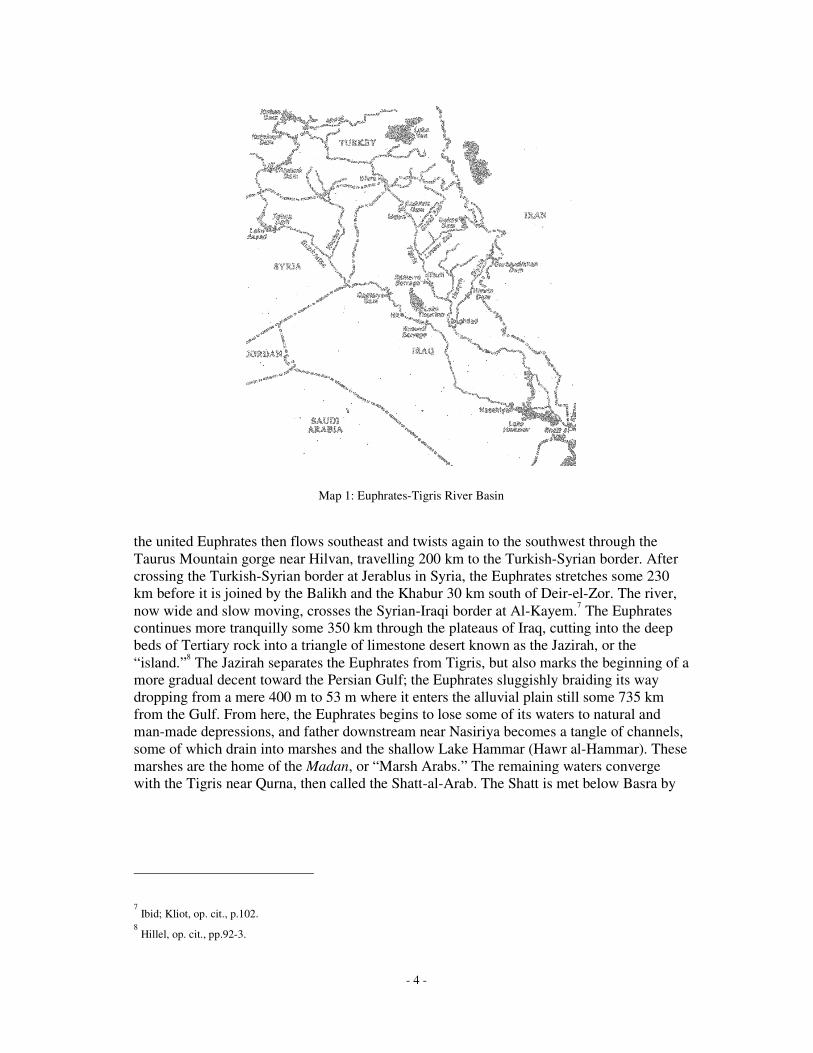
Map 1: Euphrates-Tigris River Basin
the united Euphrates then flows southeast and twists again to the southwest through the Taurus Mountain gorge near Hilvan, travelling 200 km to the Turkish-Syrian border. After crossing the Turkish-Syrian border at Jerablus in Syria, the Euphrates stretches some 230 km before it is joined by the Balikh and the Khabur 30 km south of Deir-el-Zor. The river, now wide and slow moving, crosses the Syrian-Iraqi border at Al-Kayem.7 The Euphrates continues more tranquilly some 350 km through the plateaus of Iraq, cutting into the deep beds of Tertiary rock into a triangle of limestone desert known as the Jazirah, or the “island.”8 The Jazirah separates the Euphrates from Tigris, but also marks the beginning of a more gradual decent toward the Persian Gulf; the Euphrates sluggishly braiding its way dropping from a mere 400 m to 53 m where it enters the alluvial plain still some 735 km from the Gulf. From here, the Euphrates begins to lose some of its waters to natural and man-made depressions, and father downstream near Nasiriya becomes a tangle of channels, some of which drain into marshes and the shallow Lake Hammar (Hawr al-Hammar). These marshes are the home of the Madan, or “Marsh Arabs.” The remaining waters converge with the Tigris near Qurna, then called the Shatt-al-Arab. The Shatt is met below Basra by
7 Ibid; Kliot, op. cit., p.102.
8 Hillel, op. cit., pp.92-3.

- 5 -
the Karun River, which flows from the Zagros Mountains of Iran, the combined river then continuing 77 km before entering the Persian Gulf.9
The Euphrates produces a mean annual flow of approximately 30 billion cubic metres per year (bcm/yr)10 at it entrance to Syria, and after gaining the flows from the Balikh and Khabur, flows around 32 bcm per yr at the border Syrian-Iraqi border, after which it gains no further tributaries from Iraq.11
The Tigris also originates in southern Anatolia in Turkey and is the second largest river in southwest Asia, travelling some 1,900 km. It’s name comes from the Sumerian Idigna, Tigra in Old Persian, Dijla in Arabic and Dicle in Turkish. Twenty percent of the Tigris waters lie in Turkey, 78 percent in Iraq and only two percent lie along the northeastern corner of Syria, forming the 32km border between Turkey and Syria, thus laying Syria’s claim to having “international” water rights to the Tigris.12 The upper Tigris originates in a small mountain lake called Hazar Golu, south of Elazig (only 30 km from the Euphrates headwaters) at an elevation of some 1,500 m. The second source of the Tigris is the Batman-Su, which drains from approximately 4,000 m. After crossing the Turkish-Iraqi border near Cizre, the Tigris takes a less tortuous path to the Gulf and largely flows straight toward Mesopotamia, driven largely by snowmelt, thus giving a wilder and swifter stream. No less than five tributaries, the eastern Khabur, joining at the Syrian-Iraqi border , Great Zab and Little Zab (fed by snowmelt from Iranian Kurdistan), and the Uzaym and Diyala from the Zagros Mountains of Iran, join the Tigris on its way through the homeland of the ancient Assyrians, passing through Sumarra and Baghdad.13 About 100 km south of Tikrit in Iraq, the Tigris enters its delta, at which a barrage diverts surplus waters into the Tharthar Depression. The Tharthar Depression is a manmade lake situated between the Tigris and Euphrates rivers north of Baghdad, designed to take excess runoff from the Tigris and divert it to the Euphrates River. Downstream of Baghdad, meandering 343 km and losing water to an ancient riverbed to irrigate the Mesopotamian Plain, the remainder of the Tigris waters joins the Euphrates to form the Shatt-al-Arab. Many date palms are also located along the Shatt and irrigated from its waters.
9 Ibid; Kolars & Mitchell, op. cit., p.4-5.
10 The term ‘bcm’ refers to billion cubic meters (bm3). It is noteworthy that 1.0 bcm is equal to 1.0 cubic kilometre, or
km3, i.e., 1.0 km3 = 1,000,000,000 cubic meters (m3). In the following text, bcm and km3 are used interchangeably. Typically, when referring to stream flowrates, bcm/yr is used, and likewise when dealing with reservoir volumes, km3 is used. 11
Kibaro�lu gives 32 bcm/yr as a valid value, while cited that Kolars & Mitchell gives 32.7 bcm/yr (Kibaro�lu, op. cit., p.165. 12
Kolars & Mitchell, Ibid, p.6; Hillel, op. cit., p.96. 13
Hillel, op. cit., pp.95-8.

- 6 -
The Tigris mean annual flow before it enters Iraq averages between 20 and 23 bcm per yr, and while in Iraq collects an additional 25 to 29 bcm per yr from its left-bank tributaries, totalling a yearly average flow of 50 bcm per yr.14
The combined annual flow of the Euphrates and Tigris rivers totals in the region of 80.0 to 84.2 bcm, 65.7 bcm coming from Turkey (78.1%), 11.2 bcm from Iran (13.3%), 6.8 bcm from Iraq (8.1%) and 0.5 bcm from Syria (0.5%).15 Looking at just the Euphrates, up to a massive 98.6 percent (26.5-32.2 bcm/yr) comes from Turkey alone, thus lending weight to Turkey’s claims over its extended use.16 However, the Tigris is a different story, with slightly under 65 percent coming from Turkey (28.0-33.5 bcm/yr) and the other half coming from Iraq and Iran through its tributaries (18.0-20.7 bcm/yr).17
To sum up each countries position:
�����������
��������� ����� ���� ����� ���� ����
���������� ����� ���� ���� �����
������������� ���� ��� ��� ���� ����
������������ ���� ���� �� � ��
�!�� ���"��� �� "��� ��"��� ��"��� �� "���
#�$�%��&��� ���� ���� ���� '''�!� ���� ���� ��� ''' ����
TABLE 1: Riparian Contributions to the Euphrates-Tigris Basin18
14 Kibaro�lu gives 52 bcm/yr and is the most recent publication, which agrees with Kolars & Mitchell, Hillel, Kliot,
Biswas and Dolatyar. Kolars & Mitchell records that both rivers produce hugely variable flow rates from month to month, year to year and position to position on the river. For example, at Baghdad, minimum flow recorded was 158 m3/s, the mean was 1,236 m3/s, and the maximum was 13,000 m3/s. On the Euphrates minimums and maximums were recorded as 181 m3/s and 5,200 m3/s, respectively (Kolars & Mitchell, op. cit., p.7). 15
Percentage distributions from Kliot, op. cit, Table 2.4 and 2.5, pp.112-4; Total discharges used from Kibaro�lu, op. cit., Tables 1-5, pp.166-8. Both authors have collated figures from a number of sources. It is noteworthy that Iran’s contribution comes from the Lesser Zab (5.7-6.2 bcm/yr) and the Diyalah (4-5 bcm/yr), both of which are tributaries to the Tigris. 16
Actual figure is 98.6% (Kolars & Mitchell, op. cit., p.191). 17
Kibaro�lu and Kliot, Ibid. 18
Sources: Kibaro�lu, Kolars & Mitchell and Kliot, Ibid. Including author own calculations.

- 7 -
������������� ����� ���� ����� ���� ����
����������� ��� ��� ��� '''
������������� ���� ��� ��� ''' ����
��������������� ���� ���� ���� '''
�!�� ���"��� ���"��� ��"��� ''' ���"���
�������������� ���� ���� ���� '''
�!� ���� ���� ��� ''' ����
TABLE 2: Riparian Contribution to the Euphrates River Basin
��������� ����� ���� ����� ���� ����
����������� ���� ���� ��� ����
������������� ���� ��� ��� ���� ����
��������������� ���� ���� ��� ����
�!�� ��"��� � �"��� �"��� ��"��� ���"���
�������������� ���� ���� ��� '''
�!� ��� ���� �� ''' ����
TABLE 3: Riparian Contribution to the Tigris River Basin
The flow regimes of Euphrates and Tigris separate into three seasons: high discharge, from March to June, low discharge, from July to October and average discharges from November to July.19
The two rivers constitute the ancient and mighty Euphrates-Tigris river basin. Their riverbeds are laden with silt, as much as three million tons of eroded soils advect from the highlands in a single day. Much of the alluvium deposited forms the fertile soils of the Mesopotamian Plain. However, large deposits on the riverbeds cause river instability, aiding the Euphrates and especially the Tigris to burst its banks or change courses frequently while in spate.
Finally, the Euphrates-Tigris river basin supports a diverse number of cultures and peoples, and has done so for nearly 6000 years. Although a cultural and geographical study of the basin is outside the scope of this thesis, it is worth underlying the difficulty in meeting the needs of such a diverse assemblage of peoples. In the lowlands live peasant cultivators, fellahin who irrigate lands along the banks of the rivers. Nomadic desert
19 Kliot, op. cit., p.109.

- 8 -
Bedouin graze their flocks on the arid plains, and semi-nomadic Madan, or “Marsh Arabs,” reside in the swamps and marshes. In addition, an increasing number of urbanites who inhabit the cities are using water for domestic uses. In the highlands of Kurdistan, the Kurdish mountaineers rely on water sources as do a few remaining Armenians, who though now largely displaced were expelled by the Turks early in the twentieth century.
Such basin diversity demands regional cooperation for its survival. In the following chapters, an analysis of contemporary water security for Turkey, Syria and Iraq is examined in detail.

- 9 -
� �������������������������������������
The analysis of water security in the following chapters uses the framework inspired by Buzan’s regional security complex, codified by Michael Schulz as a hydropolitical security complex, or,
“a group of states whose primary hydropolitical concerns link together sufficiently closely that their national hydropolitics cannot be realistically considered separate from one another.”20
Political, economic, social, ethnic, and legal sectors are included in the analysis.
��������������������������� ������� ���� �����
Turkey is obsessed with water works, in particular water development in Southern Anatolia and the Euphrates-Tigris basin. Turkey’s most significant project since its founding has become a bitter source of resentment to its southern neighbours, Syria and Iraq. The following sections explore Turkey’s abundant water resources and proclaimed energy deficit justifying the development in southeast Anatolia, including its hydrological significance, the societal motivations behind it, and its domestic political ramifications. A closer look at Turkey’s security complex with Syria over the PKK is examined in detail, particularly its links with water or ‘hydro-significance.’ Finally, a wider look at Turkey’s image and difficult financial situation at home and abroad is discussed.
Priorities for Water Use in Turkey
Turkey is rich in water resources in absolute terms and relative to its neighbours. Average precipitation is just under 600 mm per year (460 bcm), and internal renewable resources are estimated to be 225 billion cubic metres, 186 bcm of which are surface fed. FAO estimates indicate that of this 225 bcm, 110 bcm are actually available for use.
20 Author’s adaptation of Schutz’s and Buzan’s security complex. (Schulz, Michael, 1995, “Turkey, Syria and Iraq: A
Hydropolitical Security Complex,” in Ohlsson, Leif (ed) et al., 1995, Hydropolitics: Conflicts Over Water as a Development Constraint, Atlantic Highlands, N.J.: Zed Books). Hydropolitics is a new term that deals with the politics of international water resources. It is a revolutionary new multidisciplinary branch of science defined as “a branch of science that deals with the politics over international water resources together with their engineering and legal aspects.” See Belül, M. L., Hydropolitics of the Euphrates-Tigris Basin, M.Sc., Thesis submitted to the Graduate School of Natural and Applied Sciences, Middle East Technical University, June 1996.

- 10 -
Likewise, Turkey’s dependency ratio is less than 1 percent, as compared to 83 and 53 percent for Syria and Iraq, respectively.21 As of 2000, Turkey uses nearly 38 bcm or 35 percent of its exploitable potential, 74 percent of which goes to agriculture, 15 for domestic use (drinking water, etc.) and 11 percent to industry.22 The Euphrates and Tigris rivers account for nearly half of Turkey’s usable surface water, and a potentially sizable portion of hydroelectric capability.
FIGURE 1: Water Resources in Turkey
Energy Concerns
Before describing the GAP program, justification for such a colossal project should be put into perspective with regards to energy. As Turkey approached the mid 1970s, it became painfully aware that its energy needs and consumption were outstripping energy production. As a result, imports of petroleum increased dramatically, costing over US $5.7 billion over a ten-year period, and growing fast with a bill amounting to US $2.6 billion in 1988 alone.23 Efforts to pull oil from the Mosul oil fields, which extend from Iraq into southern Anatolia failed, and other efforts to increase coal mining were too dangerous and expensive to pursue. Turkey was reaching a crisis; energy production was growing at 33 percent but
21 Dependency ratios (DR) are the ratio of internal renewable water resources (IRWR) to actual renewable water resources
(ARWR). The higher the dependency ratio, the more a state depends of water from another state, or across a boundary. 22
See FIGURE 1: Water resources in Turkey. Water use per capita for Turkey, Syria and Iraq. Source: FAO, raw data taken from UNEP, GEO Data Portal, Sept 09, 2003, (http://geodata.grid.unep.ch). 23
Biswas, op cit., p.54.

- 11 -
energy consumption skyrocketed 172 percent.24 The exploitation of Turkey’s natural resources was approaching an asymptote, save the nation’s rivers.
Özal’s reports of the 1960s resurfaced and the government launched a massive investigation into the hydro-potential of Turkey’s rivers. Estimates reportedly put annual runoff figures for Turkey’s twenty-six river basins at 185 bcm, 62 bcm of which will be consumed after the year 2000. That left 123 bcm to be used for hydroelectric power and agriculture, a tenuous trade-off. Biswas et al. estimates Turkey’s hydropower energy potential at 35,618 MW, or 126,650 GWh.25 With the over 400 hydropower plants currently under construction, programmed or planned, targeted production is set to fulfil 63.5 percent of estimated potential, and 26 percent of estimated electricity needs for Turkey by 2010. Results from the 2001 GAP report indicate the project contributes nearly half of all hydroelectric energy produced in Turkey, and 9.3 percent of Turkey’s total electricity production, with a planned 20 percent coming from the GAP region by 2010.26 Considering energy demands increasing 250-300 percent for the near future, it is doubtful that Turkey will let up on its plans to harness the Euphrates and Tigris rivers.
The Southeast Anatolia Development Project (GAP)
A major source of tension between co-riparians on the Euphrates and Tigris rivers has been the construction of the Southeast Anatolia Development Project (or in Turkish, Guneydogu Anadolu Projesi, otherwise known as GAP). The project directly encompasses six provinces in the southern region of Turkey (Anatolia) covering an area of 73,863 km2, or 9.5 percent of Turkey: Adiyaman, Diyarbakir, Gaziantep, Mardin, Sanliurfa (referred to as Urfa) and Siirt.27
History and Influences
GAP is a major hydroelectric and irrigation development scheme to develop the Euphrates and Tigris rivers first initiated by Mustafa Kemal Atatürk in the 1930’s. He created the Electricity Studies Administration in 1936 to investigate the possibility of using waterways to create energy. The “Keban Project” later established observation posts on the Euphrates River. In 1954, the General Directorate of State Hydraulic Works, or DS� (Devlet Su ��leri), now under the Ministry of Energy and Natural Resources, was created to manage
24 Ibid, pp.55-7.
25 Ibid.
26 Southeastern Anatolia Project, GAP Latest State 2001, Prime Ministry of Turkey, Southeastern Anatolia Project
Regional Development Administration. 27
See MAP 2: GAP Region of Southern Anatolia. Source taken from GAP Home Page (English), Overall Information on GAP, What is GAP?, Aug 5 2002, Republic of Turkey, Prime Ministry, Southeastern Anatolia Project Regional Development Administration, (http://www.gap.gov.tr/images/Haritalar/tr-gap1.jpg) . Nine provinces are affected by GAP, albeit six directly.

- 12 -
Turkey’s hydrodevelopment program, in particular the utilization of ground and surface water and with the prevention of soil erosion and flood damages.
MAP 2: GAP Region of Southern Anatolia
Two very influential people had a huge effect on hydrodevelopment and ultimately the GAP program, Turgut Özal and Süleyman Demirel. Süleyman Demirel, former Premier and chairperson of the disbanded Justice Party, started as a water technician and studied hydrological engineering in Istanbul, continuing his education through the Eisenhower Exchange Fellowship in the United States. At 31 years of age, he returned to Turkey in 1955 and became the director of DS�, where he earned the nickname “King of Dams.”28 Demirel’s first stint at Prime Minister was in 1965 with the Justice Party. He became Prime Minister again in 1991 and later challenged and most formidable and long-term rival and later President, Turgut Özal in 1992.29 He lost, but succeeded Özal as President in 1993 after his death. Demirel was instrumental in obtaining $300 million for construction of Keban Dam, laid the foundation for Karakaya Dam in 1976.30 His plans for the GAP project spawned during this period.
Özal also was obsessed with GAP, extending his involvement from the 1960s until his death in 1993. He studied economics and electrical engineering in the US and became deputy director of the Electrical Studies and Research Administration in the late 1950s. He directed studies of the Euphrates and Tigris rivers, initiated by a series of publicised reports by his younger brother, Korkut Özal, highlighting the hydrological potential of the rivers
28 Kolars & Mitchell, op. cit., pp. 25-7.
29 Özal became Prime Minister first in 1983 and President in 1989, which he held until he died in 1993. Demirel succeeded
Özal as President after death (Bulloch and Darwish, Water Wars, Chapter 3 pp.58-77; Also see Greg Shapland, 1997, Rivers of Discord,” pp.111-2). 30
Kolars & Mitchell, Ibid.

- 13 -
during the 1960s.31 During this period the Ministry of Power and Natural Resources was established, and work began on the Keban Dam (1966). Although not originally planned to provide water for irrigation, it claimed to produce 600 million kilowatt-hours (kWh) of electricity and irrigate 1.65 mha.32 The ambitious drive to develop Southern Anatolia as the hydroelectric capital of the Middle East and renew Turkey’s national image came into view. In July 1992, President Turgut Özal and Prime Minister Süleyman Demirel sat next to each other in 45°C heat to christen the opening ceremony of GAP’s “Jewel of the Crown,” the Atatürk Dam; 5th largest of its type in the world, capable of producing over 2,400 Megawatts (MW) of electricity and irrigating up to 730,000 ha.33.
Objectives and Technical Details
The GAP project’s overall development objectives are to:
� raise the level of income in the GAP region by improving the economic structure of the region and thus reduce regional development disparities
� enhance productivity and employment opportunities in rural areas
� enhance the population absorption capacities of big centres in the region, and
� contribute to economic growth, social stability and export promotion as national objectives by the efficient utilization of resources in the region34
The official government statement is that the project is expected to harness 30 percent of the total water potential of Turkey, irrigate 1.7 mha of land and producing 27.5 billion kWh of electric energy annually on an installed capacity of 7485 MW.
The GAP project includes some 22 dams, 25 irrigation projects and 19 hydroelectric power plants (HEPPs). It is divided into 13 major sub-projects, 7 which locate on the Euphrates River and 6 on the Tigris. On the Euphrates, the Lower-Euphrates is the largest sub-project, encompassing the Atatürk Dam and �anlıurfa Tunnels together with five smaller sub-projects.35
31 This report is found by Özal, K., R. Kutan and F. Adak, 1967, “Development of the Euphrates basin in Turkey—A case
study.” Water for Peace: Planning and Developing, 6: 100-9, Washington DC: U.S. Government Printing Office (cited in Kolars & Mitchell, op. cit., p.26). 32
Turkish Economic News Summary, No. 310, 17 June 1966 (cited in Kolars & Mitchell, Ibid). 33
Bulloch and Darwish, op. cit., p.58. 34
GAP Home Page (English), Objectives of GAP, Aug 9 2002, Republic of Turkey, Prime Ministry, Southeastern Anatolia Project Regional Development Administration, (http://www.gap.gov.tr/English/Ggbilgi/ ghedef.html) 35
Other projects on the Euphrates are the Karakaya, Euphrates Border, Suruç-Baziki, Kahta-Adıyaman, Gaziantep and Gaziantep-Araban. Projects on the Tigris include the Dicle, Kralkızı, Batman, Batman-Silvan, Garzan, Ilısu and Cizre (Kibaro�lu, op. cit., p.174).

- 14 -
MAP 3: The GAP in southeastern Anatolia36
The furthest upstream project is Keban Dam, the first in the series of hydroelectric power plants (HEPP) on the Euphrates, though officially not part of GAP from the beginning. Constructed during 1965-74, it has a height of 211 m, a storage capacity of 30.0 bcm and produces 1,240 MW of power.37 Karakaya Dam, 165 km south of Keban was built between 1967 and 1988 and produces 1,800 MW. Atatürk Dam, named after Kemal Atatürk, founder of the Turkish state, also the linchpin of the GAP project, is located 180 km south of Karakaya Dam near Bozova and produces a considerable 2,400 MW of power, or one-third of GAP’s electrical power. It also has potential to irrigate over a half-million hectares of land via the �anlıurfa Tunnels.38
The Atatürk Dam is a significant source of conflict between Turkey and Syria. Filling the reservoir in 1990, Turkey stopped the Euphrates flow for a month. This incident is discussed in Chapter III. The �anlıurfa Tunnels are another major addition to the project, each 7.62 m in diameter and 26 m long. They are designed to take water away from the Atatürk reservoir at a rate of 328 m3/s, or 5 million gallons per minute, to irrigate 150,000 ha on the �anlıurfa-Harran plains, as well as producing 50 MW of power. Total electrical capacity on the Euphrates is estimated at 6,538 MW, and irrigation totals for 8 projects centre around a million hectares.39 More importantly to Turkey’s downstream riparians, projects planned for the Euphrates could reduce the mean flow on the border by 30 percent,
36 Kliot, op. cit., p.124.
37 Kliot, op. cit., p.126.
38.Ibid, Table 2.8 p.127.
39 Other dams include the Birecik, the Karkamis and the Kahta-Adıyaman producing 672 MW, 180 MW and 196 MW,
respectively (Kliot, op. cit., p.129.

- 15 -
or 10.9 bcm.40 This is obviously the apex of concern for Syria and Iraq, and estimates of Turkey’s withdrawals are a subject of intense controversy amongst politicians and academics.
Tigris development is less dramatic realising a third the energy produced by the Euphrates and irrigating half as much, but is also significant part of GAP. The Dicle Kralkızı project includes two dams, the Kralkızı Dam that will generate 90 MW and the Dicle Dam producing 110 MW. Both dams will irrigate 126,080 ha. The Batman project also includes two dams and HEPPs, producing 185 MW and irrigating 37,744 ha on both banks of the Batman River. The Batman-Silvan and Garzan projects involved the construction of two dams, producing 300 MW and 90 MW, respectively and irrigating 273,000 ha combined. The Ilısu Dam, a large dam, envisaged for producing electricity only, will generate 1,200 MW. Moreover, the Cizre project and HEP, located just upstream from the Turkish-Iraqi border, produces 240 MW and will irrigate 121,000 ha of land in the Silopi-Nusaybin-Cizre region. The total area planned irrigated by the Tigris portion of GAP is estimated at 557,741 ha, consuming some 35 percent of Tigris river flow, or 7 bcm.
Controversy over amounts and timing of GAP plans to divert water from the Euphrates and Tigris river basins are the primary concern between co-riparians. Most commentators agree that when all GAP projects are up and running on the Euphrates, natural flow to Syria will reduce by over 30-55 percent (10-16.9 bcm/yr), and as much as 80 percent (25.6 bcm/yr) to Iraq.41 Tigris withdrawal estimates are less contentious, because the river only briefly adjoins Syria’s border and Iraq and her tributaries contribute over half of its flow. Nevertheless, estimates range from 10-14 percent of its total flow (5-7 bcm/yr), total flowing being near 52 bcm per year where the Tigris meets the Euphrates and flows into the Shatt al-Arab. The issue is particularly acute for northern Iraq in irrigated areas north of Mosul and Kurdistan, where 5-7 bcm per year accounts for a 25-35 percent reduction in flow at the Iraqi-Turkish border. The long-standing issue of Kurdish separatism and Turkish interest in the oil fields surrounding Mosul add to the difficulty in resolving flow reductions on the Tigris.42 Conflicts over water are discussed in Chapter III.
GAP starting out as purely hydroelectric and irrigation scheme, but has transformed into an enormous multi-sectoral, socioeconomic regional development program.
40 Ibid.
41 Timing estimates range from maximum depletions in 2005 to 2040. Hillel, op. cit., pp.107-11; Dolalyar, op. cit., p.144;
Kibaro�lu, op. cit., p.182; Kliot, op. cit., pp.132-5; Biswas, op. cit., pp.74-5. Kolars & Mitchell work seems the most thorough, but the most damning, with withdrawals peaking by 2040. 42
In fact, Turkey had plans to annex Mosul and Kirkuk in 1990. See Berdal Aral, Jan 2001, “Dispensing with Tradition? Turkish Politics and International Society during the Özal Decade, 1983-93,” Middle Eastern Studies, 37 (1), p.79.

- 16 -
“Expected high potential in both industry and agriculture will increase the income level of the region fivefold and create employment for 3.5 million people in the region whose population is projected to reach more than 9 million in 2005.”43
GAP’s goals and strategies changed with the times, and more recently they have been influenced by global thinking on social, cultural, economic and environmental projects, reflected by debates held at the 1992 Conference on the Environment and the 1995 World Summit for Social Development. Turkey, concerned about its image and funding for the project (more on this later), has tried to incorporate some of these ideas into the GAP Regional Development Administration (GAP-RDA). GAP-RDA’s strategy is expressed in the GAP Master Plan:
� To develop and manage water and land resources both for irrigation and also for urban and industrial use,
� To improve land use by introducing better farm management, agricultural practices and crop patterns,
� To encourage manufacturing industries by giving special weight to agriculture related and local resource based production lines,
� To improve social services and urban infrastructure facilities to better respond to the needs of local people and to attract and keep qualified personnel in the region44
From a project aimed only at producing vitally needed energy, emerged a massive domestic and political tool, a symbol of national pride gaining support across all parties and ideological orientations (and budgets), except in Syria and Iraq, of course. Çarko�lu and Eder express this idea in terms of Turkey’s perceived security,
“The high saliency of the project both from a regional development perspective and from the perspective of national integrity and security, makes it a policy area that keeps the attention of the ruling parties focused.”45
Original planning for the GAP project focused primarily on hydroelectric facilities and later included irrigation schemes. More recent modifications and expansion to GAP redefines the project as a socioeconomic regional development program, emphasising Turkey’s needs to transform southern Anatolian from a “backward society” to one of economic growth and social prosperity. This also addressed international security concerns,
43 GAP Home Page (English), History of GAP, Aug 14 2002a, Republic of Turkey, Prime Ministry, Southeastern Anatolia
Project Regional Development Administration, (http://www.gap.gov.tr/English/Ggbilgi/gtarihce.html). 44
GAP Home Page (English), GAP Master Plan, Aug 5 2002b, Republic of Turkey, Prime Ministry, Southeastern Anatolia Project Regional Development Administration, (http://www.gap.gov.tr/English/Ggbilgi/ gmaster.html). 45
Çarko�lu, Ali and Mine Eder, Jan 2000, “Domestic Concerns and the Water Conflict over the Euphrates-Tigris River Basin,” Middle Eastern Studies, 37 (1): p.42. Also on the ‘domestic’ point, see Biswas, Asit K., 1994, International Waters of the Middle East, p.50.

- 17 -
i.e., Turkey’s relations with the European Union (EU) and the Kurdish issue, both of which are addressed next.
Regional Development of Southern Anatolia
The nine provinces of the GAP region (southern Anatolia) contain over 6.6 million inhabitants in 1998, growing at 2.5 percent per annum, not quite twice as fast as Turkey’s average population growth. Equally, urbanisation is also increasing twice that of Turkey as a whole. However, probably the most important in terms of socioeconomics is the fact that nearly 30 percent of the economy in the GAP region comes from agriculture, with close to 75 percent of rural areas working in agriculture. Only 17.4 percent come from industry, compared with the rest of Turkey, which averages at 14.5 percent for agriculture and 25.3 percent industry.46 Similarly, the region produces only 5.2 percent of Turkey’s GDP. The social indicators express the same concern, with life expectancy 2.5 years below Turkey’s average, overall human development index at 0.61 compared to 0.72, adult literacy 20 percent below Turkey’s 83 percent value, and probably the most remarkable, real GDP per capita ($PPP) at half of what it is for Turkey, $3,384 compared to $6,339.47 The figures give justification to major investment to the area and are somewhat represented by the Turkish government’s claim to “increase the income level of the region fivefold and create employment for 3.5 million people.” However, there is also another significant domestic political factor behind the government’s interest in southern Anatolia. Votes.
Given the low GDP, population and human development figures, money and development into the GAP regions corresponds to votes. High electoral volatility suggests that votes in the region are easily mobilised, where some 95 percent of some villages vote for one party or candidate. In addition, given the long struggle to handle the violent and highly visible Kurdish insurgency in the south, this fact completes another piece of the puzzle and explains the widespread commitment within the Turkish government to develop the region.
Security in the South – The Kurdish Issue
Turkey’s struggle with the “Kurdish issue” or the “Kurdish question” is long been documented and recognized internationally in an intractable conflict between Kurdish rebels and the Turkish government. The Kurds occupy 50 percent of the GAP region, however their settlements in southern Turkey are not only confined to the six major provinces of
46 Figures come from Çarko�lu and Eder, op. cit., Tables 1-3, 44-7. Interestingly, Turkey’s own figures reported in 2003
show 40% of agriculture in GDP for GAP region, and only 11% in manufacturing. (Turkey: Country Report, 2003 World Water Council, Ministry of Foreign Affairs, Department of Regional and Transboundary Waters, General Directorate of State Hydraulic Works, Southeastern Anatolia Project-Regional Development Administration, Republic of Turkey, See box, p. 113). 47
Ibid.

- 18 -
southern Anatolia, but include major portions of eastern Turkey and central Turkey, the northwest region of Iran, northern Iraq and north-eastern Syria, as well as regions of Georgia, Armenia and Russia.48 The Kurds, occupying 19 percent of Turkey, 23
MAP 4: Kurdish Areas in the Middle East.
percent of Iraq and nearly 10 percent in Syria, totalling some 35 million people, are culturally and ethnically distinct from inhabitants in their resident states. They are represented politically by the PKK (Partia Karkaren Kürdistan, or Kurdistan Workers’ Party), generally regarded as a terrorist organization by Turkey, the KDP (Kurdistan Democratic Party) and PUK (Patriotic Union of Kurdistan) both of which reside in Iraq. The Kurdish issues directly relate to Turkey’s water security policy in the GAP region, more so than economic or social concerns.
The “Kurdish question” runs much deeper into the Turkish psyche than a mere armed struggle for minority rights. There is a genuine lack of cultural identity allowed to the Kurdish people, and a feeling that Turkish culture supersedes the Kurdish one. This attitude is expressed by the amazingly offensive Turkish expression for Kurds by some as “mountain Turks.” There are even some who believe that the Kurdish population have been treated fairly and that they should simply stop whining and assimilate with the Turkish state. These same voices also refute the cultural uniqueness of the Kurds, and have deliberately set out to link them with Turkish ancestry.49 The attitude towards the Kurds runs back to Turkey’s contemporary beginnings.
Mustafa Kemal Atatürk went on to remove the clause retaining Islam and the state religion from the constitution in 1928, creating a secular state.50 Atatürk’s intense
48 See MAP 4: Kurdish Areas in the Middle East. Figure taken from CIA maps division, 2003, (http://www.cia.gov).
49 Bayazıt, op. cit., p.78-83. He states, quite nonsensically, “They were of Turkish origin sense the world Kurd was
mentioned in the Göktürk Inscriptions, the oldest written text in Turkish.” 50
Mustafa Kemal Atatürk, known as Atatürk meaning “father of the Turks,” established the independent Turkish republic in 1924 after defeating the British at Gallipoli.

- 19 -
nationalism, known today as Kemalist secularism, became the foundation by which the Turkish state was built. All public vestiges of Kurdish identity were crushed, speaking and teachings in Kurdish were outlawed, broadcasting stations in Kurdish were denied licenses and the expropriation of Kurdish land to Turkish settlers began in earnest.51
The Turkish modernist project to build a “national state” was unclearly represented by changing policy towards the Kurds. After significant suppression by 1950, it was thought that ethnic groups in Turkey would have simply “melted into a Turkish identity.” Even though leftists challenged government policies, there was a clear and persistent denial of the existence of a separate Kurdish identity. As the leftist voices grew louder, two approaches emerged within the government. The first view supported that there was no Kurdish problem, just “mountain Turks” reining terror against the secular state, rooted by poor economic and social conditions, and supported by the international community. The second and less popular stance supported by Turgut Özal in the 1980s admitted the denial of cultural and ethnic identity afforded to the Kurds, and spoke of the “Kurdish Reality.”52 However, this outlook quickly drowned due to political scandal and allegations of support to the PKK and Kurdish separatism by Parliament members of the HEP/DEP (People’s Labor Party and its successor, Democratic Labor Party). Despite some support in Parliament and the fact that many Kurds who at one time or another supported greater pluralism in Turkey, they began to turn to separatism; racism mixing with nationalism on both sides began to fuel a conflict already marred by murder and terrorism.
The Kurdish minority are due to become Turkey’s largest ethnic group by 2020, posing a threat to the Turkish security perception inflamed by Kurdish separatism and desire to be a distinct and separate nation.53 Despite the cultural friction between the modern Turks and Kurds, clearly the more recent imposition of borders dividing ancient Kurdistan and leaving it stateless has done much to aggravate cooperation between the two groups.54
Nevertheless, in 1989 Turkey made the connection between regional security in southern Anatolia, “socioeconomic backwardness”55 and the Kurdish problem by reorganizing the GAP master plan, including reshuffling the GAP administration and a redefining the state’s role in region. It determined poor economic performance and unequal
51 Mango, Andrew, 1999, Atatürk, London: John Murray, p.134-214.
52 Kiri�ci, Kemal, 1998, “The Kurkish Question & Turkish Foreign Policy.” International Quarterly Journal of TÜS�AD,
p.75. 53
13.8 million Kurds in Turkey by 1990, or 25% of the population, 19 million in 2000 (29%) and an expected 32.8 million by 2020, or 38% of Turkey’s population. (Population Reference Bureau, 2002, World Population Data Sheet, Washington, DC). The Kurdish history traces back to a distinct cultural heritage, going back some 8000 years, illuminating a colourful yet tragic history. Ethnically, the Kurds intermixed with the Halaf, Ubaid, Hurrian and Aryan peoples before coming in contact with the Turks. Their territory remained around the Zagros Mountians, spanning the now modern states Syria, Iraq, Turkey and Iran. For a good but brief history on the origins of the Kurdish people, see Dr. M. Izady, Colombia University, New York, USA, (www.kurdish.com). Otherwise see D. McDowall, 1992, The Kurds, a Nation Denied, London: Minority Rights Group. 54
See article by Dr Hussein Tahiri, “The Kurdistan Republic of 1946,” January 2003, KurdishMedia, (www.kurdishmedia.com). 55
Çarko�lu and Eder, op. cit., p.49.

- 20 -
distribution of land were the primary factors feeding the Kurdish issue.56 Pumping money and development into the region was seen as an effort to integrate the Kurdish population and subsequently reduce PKK activity. Increased economic prosperity supposedly meant to undermine the rebel movement. In reality, it had the opposite effect, and PKK activity increased. The announcement of GAP plans in 1984 coincided with the formation of the PKK.
The first Kurdish fear of GAP was that it would forcefully assimilate them into Turkish society by moving them off their land and into cities, with some justification for by 1990, 210,000 residents from over 300 villages were already displaced due to the filling of the Keban, Karkaya and Atatürk reservoirs.57 There was a sense of abandonment from the Kurdish rural community, as Turkish ‘integration’ meant breaking up the sacred clanism for statism.58
Secondly, concerns are fierce surrounding the fact that major land development due to GAP were mainly to benefit the Turkish government and multinationals, and land development and public ownership were just ‘catch phrases’ to convince locals of their motives. There is a genuine lack of trust between the Kurds and Turkish government and GAP officials, neither believing that true land redistribution was ever on the cards. Promised land reforms never materialised in the GAP region.59
Additionally, rapid building of dams and filling of reservoirs is drowning Kurdish historical sites, many of them thousands of years old. Between 150,000 and 200,000 people were displaced due to the Atatürk Dam, flooding over 300 villages and the entire town of Samsat. No relocation plans were in executed by the DS� for the Atatürk project and over 80% of dislocated people received little or no compensation. Effects of the planned Ilisu Dam look to be just as damaging, threatening 183 villages and 78,000 people and unquestionably flooding the ancient Kurdish town of Hasankeyf. Many local villagers have thrown up their hands in disgust, simply insisting that no one it listening to them. It is easy to see how local frustrations can turn into violence, threatening security in the region. From a Kurdish perspective, the Turks were using their water as a weapon against them.
In 1987, Turkey pursued and signed a protocol with Syria linking security issues at the border and subsequent suppression of PKK forces and water flow on the Euphrates.60 Syria,
56 Some 61 percent of farmers own less than 5 ha, and 10 % of the population own 75 percent of the land (Ibid).
57 A. Soffer, 1992, Rivers of Fire: The Conflict Over Water in the Middle East, p.91.
58 Adams, Mark, 2002, Water Security Policy: The Case of Turkey, Near East South Asia Center for Strategic Studies
(NESA), p.37. 59
For more on land reforms, see Turkey: Country Report, 2003 World Water Council, op. cit., pp. 117-23; Southeastern Anatolia Project, GAP Latest State 2001, op. cit., p.18; Olson, R., 1996, “The Impact of the Southeast Anatolian Project (GAP) on Kurdish Nationalism in Turkey,” The International Journal of Kurdish Studies, 9 (1-2): 95-102. 60
Syrian support for the PKK and Iraq’s role are addressed in Chapter III and IV.

- 21 -
led by President Assad, knew how to play the “PKK card” with Turkey, securing water in return. An illustration of this was a conversation in April 1992 between a Turkish diplomat and President Assad, where the meeting was to clarify terms of the security protocol signed in 1987. Turkish Interior Minister Ismet Sezgin speaking to Assad said, “Can I say when I go back to my country that the PKK problem will be solved?” President Assad replied, enigmatically, “There will be cooperation to solve the problem.”61 Nevertheless, tensions increased systematically until the 1998 where the two countries nearly went to war with each over Syria suspected and probably generous, assistance to the PKK. This is incident and other water related conflicts are discussed in detail in Chapter III.
By the early 1990s, Kurdish insurgency across the Iraq-Turkish border was occurring almost daily. The Gulf War and following Iraqi military aggression against the Kurdish communities in northern Iraq do doubt refuelled the issue, as did continuing Iranian and Syrian covert support for the PKK and associated forces. Since 1984, when PKK starting operating, nearly 30,000 people have been killed and 400,000 displaced due to confrontations between Turkish security forces and the PKK.62 Moreover, amalgamations of conservative and staunchly nationalist parliamentarians showed no sympathy on the Kurdish issue, supporting crack downs during the 1990’s, raiding over 3,000 villages using some 50,000 troops, spending a massive US $8 billion a year, although severely reducing numbers of the PKK’s guerrilla peshmerga, or warriors. It is easy to see how this trend had serious implications for Turkey’s budget, let alone its security concerns. Incidentally, the budget had long been in the red with accompanying inflation running gallantly over 70%.
In 1999, Turkish Secret Police and CIA operatives in Kenya captured Abdullah Öcalan, the leader of the PKK, in Nairobi. A wave of violent protests followed his arrest and subsequent imprisonment in Turkey. After his trial he was found guilty and sentenced to death. Öcalan ordered the PKK to end its armed struggle, surrender its weapons and withdraw its peshmerga from Turkey. The PKK subsequently changed its name to the Kurdistan Freedom and Democracy Congress, or KADEK, and has been working toward assimilation and national reform to hopes to win minority status for the Kurdish population in Turkey. However changing the attitude of a hugely protective and nationalistic Turkey has been frustrating, and calls for reform are mired in political cyclones of debate. Vehement nationalist republicans, the likes of Bülent Ecevit have delayed progress toward Kurdish inclusion and democratic rights. Ecevit was quoted as saying, “There is no Kurdish problem in Turkey, but the problem of feudalism in the southeast.”63
However, Ecevit’s hardnosed politics were causing schisms in his coalition, and by July 2002, eight ministers including Foreign Minister Cem stepped down, forcing out Ecevit at the start of 2003.64 This resulted in ascension of Justice and Development Party leader
61 Bolloch and Darwish, op. cit., p.67.
62 Economist, 18 February 1999, “An ancient tragedy,” print ed., pp.1-5 (www.economist.com).
63 Quoted by former PM Bülent Ecevit (1998-2001). Alpay, �ahin, Spring 2000, “After Öcalan,” PrivateView
(International Quarterly Journal of TÜS�AD), p.39. 64
Elected Prime Minister (PM) from 1998, he was thought of as a ‘liberal’ by Turkish decrees, but his actions indicated otherwise. Having served as PM to less than seven times since 1972, Bülent Ecevit has played tough with Greece, sending

- 22 -
Recep Tayyip Erdogan to Prime Minister in March and the eventual relaxation of legal restrictions on freedom of speech and on Kurdish language rights, also reducing the political role of the military. In August 2002, Parliament championed legislation lifting the ban on Kurdish education and broadcasting. Both Erdogan and President Ahmet Necdet Sezer are regarded as secularists, which will critical if they are to remain in their seats without interference or simply ousting by the powerful Atatürk military.
In addition, Erdogan and Ahmet are steering Turkey toward acceptance to the European Union in 2012, and it could be argued that significant moves to reform the government and legal system, such as the abolition of capital punishment in 2001, are simply are the backdoor into Europe. After all, it was the European Court of Human Rights’ ruling that ultimately saved Öcalan from execution, ultimately prompting Turkey’s parliament to eliminate the death penalty.65 Thus, the Kurdish issue in Turkey intimately interrelates to its security and national image. The connection between security and image is addressed next, which is a critical moving force behind Turkey’s policy of security its water rights on the Tigris and Euphrates.
Turkey’s image – National Integrity and Financial Constraints
Turkey’s image is quite understandably, hard to figure and at the outset a complex subject of study probably best left to those who share in Turkey’s cultural heritage. However, it is worth noting a couple of significant factors relating to Turkey’s image and its water security.
First, Turkey’s policy toward the Kurdish issue permeates directly into Turkey’s image at home, and particularly affects Western views on Turkey’s human rights record. Turkey has been keen to join the ECC and more recently, the EU, since its submission was rejected in 1989. Turgut Özal personally committed himself to assure Turkey ascension to the EU and hence, as he saw it, more “Western looking.” He enjoyed huge support from America and endeavoured to drive Turkey’s political forces away from a blend of conservatism, which rejected political state-centred Islam, Western-orientated foreign policy and supported xenophobic nationalism. Özal’s Motherland Party, which contained Liberals, Conservatives, Social Democrats and Extreme Nationalists, sought to make use of Turkey’s Ottoman heritage and promote tolerance and pluralism, putting an end to exclusion (by the state) of cultural expressions of Islam, the Kurdish identity and other repressed identities, such as the Armenians. Özal sought to legalize Kurdish rights and claims by Islamists, rather than outlaw them. Legalising the use of the Kurdish language in public and recognizing the Kurdish New Year are among his more successful reforms. In retrospect, Turgut Özal was a true visionary in Turkish terms, looking to accept and use the “best of the
30,000 troops into Cyprus in 1974 and launching a number of violent raids in southern Anatolia in 1999, the day after capturing Öcalan. See the Economist, April 24 1999, “Bulent Ecevit, Turkey’s survivor,” p.56. 65
BBC News World Edition Europe, 3 August 2002, “Europe welcomes Turkish reforms,” (news.bbc.co.uk/2/hi/europe/2170331.stm).

- 23 -
West” while threading the political fabric with Turkey’s rich cultural history, always mindful of pacifying stanch conservatives. Thus, Turkey’s more inclusive policy toward the Kurds, largely constructed by Özal, directly reflected Turkey’s projected image toward to West and its own self interest in becoming ‘Western enough’ to be part of the EU club.66
Secondly, Turkey’s image at home trumpeted claims of the “cradle of civilisation” and endeavoured to convince its financially troubled economy that water works in southern Anatolia were going to reform the Turkish economy. Turkey’s fervour to retain its image at home squares directly on the success of GAP. Its expertise lent to harnessing the waters of the Euphrates and Tigris rivers is a source of national pride. GAP projects on the two rivers are meant to revive a sick economy in the south (it was damaging the Turkish economy overall), solve the Kurdish PKK issue and provide the nation with a source of expertise and mastery over waters in Anatolia.
Nonetheless, Turkey’s continued conflict with downstream riparians, Kurdish nationals and international scepticism coloured her image at home. Increased international media coverage of the drowning of Hasankeyf and gross negligence over planning for resettlements on the Ilisu Dam project weakened the government’s moral high ground. Reports indicate that up to 183 villages and over 78,000 people are will be displaced, most of them Kurdish.67 As a result, environmental organisations took the opportunity to throw in their lot, often using ammunition supplied by Kurdish human rights groups, such as the Kurdish Human Rights Project, who incidentally, has done brilliant work advocating for comprehensive resettlement plans and minority rights. Nevertheless, reports of village curfews, food embargoes and forced evacuations and increasingly, human rights violations by Turkish forces, are tried and won by the European Court of Human Rights.68 Controversy surrounding the Ilisu Dam underlines the importance of Turkey’s image regarding continuing GAP projects and their social and environmental impacts.69
The negative attention is costing the Turkish government millions in lost export credits, international funding and effecting large pullouts by Balfour Beatty and Impregilo of Italy, among others previously scheduled to build dams under the GAP plan.70 The legacy of
66 Aral, Berdal, January 2001, “Dispensing with Tradition? Turkish Politics and International Society during the Özal
Decade, 1983-93.” Middle Eastern Studies, pp.80-2. 67
Kurdish Human Rights Project Report (KHRP), 2000, “The Ilisu Dam, the World Commission on Dams and Export Credit Reform: The Final Report of a Fact-Finding Mission to the Ilisu Dam Region.” London: Kurdish Human Rights Project, Executive Summary. 68
See KHRP Case Report, 1996, “Akduvar vs. Turkey: The Story of Kurdish Villagers Seeking Justice in Europe,” London: Kurdish Human Rights Project. 69
Major concerns over the project stated were: First, that the long and continuing history of repression of the Kurdish majority in the region by the Turkish State makes a just outcome to the project unrealizable; Second, that the project, which will flood the homes of up to an estimated 78,000 people, fails to meet the most basic international standards with regard to resettlement and environment; Third, that the destruction of the ancient Kurdish town of Hasankeyf, a site of international archaeological importance, which would be partially submerged under the dam's reservoir, is an unacceptable price to pay for the project; and Fourth, that the dam has the potential to exacerbate regional conflict over water between Turkey and its downstream neighbors, Syria and Iraq. (KHRP Report, 2000, “The Ilisu Dam, the World Commission on Dams and Export Credit Reform…, op. cit., p.20). 70
BBC, “Turkish Dam Controversy,” January 2000, (http://news.bbc.co.uk/2/hi/europe/614235.stm#top).

- 24 -
waning international support is not new to GAP. The World Bank and IMF decided not to fund any part of GAP (since Karakaya) due to concerns over published social and environmental impacts. The KHRP’s report reflects their position by stating,
“[t]he project violated numerous internationally-recognised benchmarks for the funding and implementation of infrastructure and development projects, abrogating five World Bank policy guidelines on 18 counts, in addition to the OECD's Development Assistance Committee's guidelines on projects involving involuntary resettlement. The Berne Declaration also warned that the project contravenes core provisions of a UN convention aimed at preventing wars between states that share water resources.”71
Amazingly, Turkey still refused to debate the issue at the interstate level, further damaging its image abroad but saving attempting to save face at home, seeing the issue as a matter of sovereignty. Looking at a shortfall of US $3.5 billion for required funds for energy projects, Turkey stood its ground expressing its regret over Western ‘unreasonableness’, and sought contracts from other Western consortiums that were less ‘ethically critical’.
This point underlines the financial pressures Turkey is experiencing over GAP and its perception, at home and abroad. Out of the US $32 billion planned for GAP, nearly US $14 billion has been spent as of 2002, or nearly 50 percent, but most of that had to come from Turkey itself due to lack of foreign funds. High inflation, due mostly to spending on GAP, flowing over 70 percent in the early 1990s and averaging around 60 percent since has taken a toll on its books, owing some US $115 billion in 2002 and spending over 80 percent of its GDP on public debt.72 This and other factors has led to a drastic devaluation of the Turkish Lira, down 100 percent since 1993.73 Lack of foreign investment, domestic economic decline, difficulty in land redistribution and international pullouts on major hydroelectric works have severely reduced spending on GAP and consequently delayed its completion.74 Financial issues have played an important role in GAP’s perception at home in Turkey, and continue to be a source of identity and pride, albeit precarious, within the government.
71 KHRP Report, 2000, “The Ilisu Dam, the World Commission on Dams and Export Credit Reform…, op. cit., Summary.
72 Economist Intelligence Unit, Country Briefings, June 2003, (www.economist.com/countries/Turkey/
EconomicData.cfm); Beschorner, 1993, Water and Instability in the Middle East, p.32. 73
See FIGURE 2: Devaluation of Turkish Lira (TL to US $). Exchanges rates taken from FX History: historical currency exchange rates, (www.oanda.com). 74
See FIGURE 3: Share of Public Spending on GAP. Public spending data taken from Southeastern Anatolia Project, GAP Latest State 2001, Prime Ministry of Turkey, Southeastern Anatolia Project Regional Development Administration, p.6.

- 25 -
������
�����
����� �!"�
#� ��#��! �
��
���
���
���
���
����
��� ���� ��� ���� ���� ���� ���� ���� ���� ���� ���
FIGURE 2: Devaluation of Turkish Lira (TL to US $)
����
����!�#�
��
��
��
��
��
���
���� ���� ���� ���� ���� ���� ����
FIGURE 3: Share of Public Spending on GAP
Finally, and no less spectacularly, Turkey, hoping to win support abroad and in particular the Middle East over assertive hydropolitics, sought to build a “peace pipe” to supply water to from Turkey to the Arabian Peninsula. The plan, instigated by Özal in 1987, proposed two separate pipelines, a western branch to supply Syria, Jordan, possibly Israel and Saudia Arabia, and an eastern branch, serving Kuwait, Saudi Arabia, Bahrain, Qatar, UAE and Oman. The pipelines would be 2,650 km and 3,900 km long, supplying 1,277 and 0.912 bcm per year, respectively. At first glance, it sounded feasible, but suspicions in the Middle East run high, especially if Israel is included. In addition, increased interdependence remains an elusive concept, often being perceived as weakness toward the states on receiving end. The project, although meticulously planned, was more of an image building

- 26 -
mechanism for Turkey, at a time where its water policies were under severe scrutiny (5 yrs after formal launch of GAP) and Özal was sowing his seeds toward EU membership.
Military Security and Links to Water
While military is not the focus of this study, it deserves a brief mention insofar as its aforementioned link to water issues. Syria joined a pact with Greece after 1995, both working against the interests of Turkey. Turkey, anxious that a Syrian-Israeli peace deal could redistribute troops to the Syrian-Turkish border, quickly initiated an Israeli-Turkey military alliance, including shared intelligence that ultimately aided in Öcalan’s capture. Before challenging Damascus over the PKK in 1998, Ankara determined they had a military advantage over Syria, although Syria’s deal to get arms from Russia was worrisome. Likewise, Turkey after 1990 had significant military advantage over Iraq. Their siding with the allies after the Gulf War and membership to NATO is a threat to both Syrian and Iraqi security.75
$������ ����� ���
Turkey is rich in natural resources, particularly water, but is not self-sufficient in energy production. Rising population growth during the 1950s sparked plans to exploit its natural resources in southern Anatolia. However, Syria, Iraq, and an increasingly violent Kurdish minority disrupted plans to achieve funding for the GAP project, putting the life-long dreams of Turkey’s ‘hydraulic heads of state’ as risk of failure. Turkey’s capacity to develop the Euphrates and Tigris rivers hinges on solving the Kurdish question and maintaining an image of strength in the West & Middle East, attracting desperately needed funding and resulting in high-level political involvement linking traditional security to Euphrates and Tigris water use. Supported by claims of economic prosperity in the south, the results remain to materialize, as only 12 percent or 215,080 ha of irrigation projects are currently under operation, another 152,084 ha under construction.76 Turkey’s economic priorities are clearly hydropower, demonstrated by nearly 80 percent cash realisation of GAP hydro-projects by the end of 2001 in contrast to only 16 percent for agricultural projects.77 Turkey’s own investment in GAP has damaged its economy contributing to severe inflation and massive public debt.
75 Mark Adams, 2002, Water and Security Policy: The Case of Turkey, pp.12-15.
76 Southeastern Anatolia Project, GAP Latest State 2001, op. cit., p.9.
77 Ibid, p.5.

- 27 -
What does this mean for downstream riparians? Turkey’s water security is clearly driven by not only economics, but political motivations, regardless of proud claims to irrigate 1.7 million hectares. The technical stance taken by Turkey regarding water allocations is helpful, but any successful cooperative arrangement to share Euphrates or Tigris waters from Turkey will have to go further to address mutual regional security agreements first, followed by strengthening economic interdependencies. Interestingly, social and environmental concerns seem to take low priority in Turkey’s development agenda. Concerns from downstream riparians focus on Turkey’s projected use (withholding) of water and water pollution, threatening Syria and Iraq’s water security.

- 28 -
� ������������������������������������������������
� ����� ����������������
Water security for Syria and Iraq are more similar to each other than they are with Turkey. The following chapter first looks at the water security situation in Syria, paying close attention to indicators of Syria’s struggling economy. Development on the Euphrates is then analysed relative to Syria’s needs for irrigation and domestic water, and links between rebel groups and Syrian foreign water policy with Turkey are discovered. Political links are also related to Syria’s claim over the Hatay Province in Turkey.
Iraqi water security begins with a historic look at Mesopotamian hydraulic culture. Likewise, Iraq history of development on the Euphrates and Tigris are investigated, paying special attention to deteriorating water quality, followed by an analysis of Iraqi water resources and needs. Like Syria, Iraqi food security is tenuous and places great demands on water and land use. Finally, Iraq’s international conflicts are discussed with reference to its economy, followed by political arguments.
The chapter concludes with an analysis of two specific conflicts over water: the first between Syria and Iraq in 1975, and the second between Turkey and both Syria and Iraq in 1990.
%��������� ���������� ��
Pressure to Maintain an Agrarian Based Economy
Agriculture has always been a significant factor in the Syrian economy, relying largely on irrigation supplied from the Euphrates River. Nearly 95 percent of water withdrawn in Syria goes to agriculture, 3.3 percent for domestic use and 1.8 percent for industry.78 In the mid 1950s, agriculture accounted for 50 percent of national income (GDP) involving 70 percent of the population. Now it only accounts for 22.5 percent of the labour force and 28 percent of GDP.79 With the agricultural labour force decreasing, increases in urban
78 FAO, AQUASTAT database, 2003, (www.fao.org/ag/agl/ aglw/aquastat/countries/index.stm).
79 See FIGURE 4: Population Trends for Syria. The graph is using data from FAO AQUASTAT database, 2003, Ibid. Note
that figures show percent in agriculture at 27%, where as actually workforce is somewhat less at 22.5% due to temporary and foreign labour.

- 29 -
population 3.5 percent per annum and agriculture still a player in the national economy, Syria had put itself into a position where it had to quickly boost food production or start importing large amounts of food to feed its people.
���
��
���
��
���
���
���
���� ���� ���� ���� ���� ����
� �� ����������������������
�
�����
�����
�����
�����
������
������
������
������
������
������������������������
������� !���������� "��# !������� �����$������
�%��%��
FIGURE 4: Population Trends for Syria
Syria has long pursued a self-sufficient strategy when it comes to food security, albeit marginally successful. Up until the early 1970s Syria was managing to equal its imports and exports, both increasing at relatively modest rates of US $3-5 million per year. In 1974, imports surpassed exports significantly for the first time, and from that point Syria became a net importer of goods while also continuing to strive for self-sustainability.80 Massive drought, struggling oil prices and a weak economy during the late 1970s and 1980s made matters worse and forced thousands of rural workers to seek employment in urban areas. Oil exports became vital during the eighties drought years as the government needed cash for importing food to a rapidly growing urban population. It is noteworthy to mention the fact that Syria’s rapid population growth seems to be slowing by 2001 (2.6%), probably partly due to family planning programs started in the mid 1990s.81
80 See FIGURE 5: Agricultural Import/Export History for Syria. (data from FAOSTAT database). Notice the dip in labour
concentration in agriculture during the 1980s, partly due to workers fleeing the land during the draught years. 81
In FIGURE 4, note that the Total population trend equals that of the Urban trend, thus indicating that growth is occurring in the cities and urbanized zones, i.e., Urbanization. This explains the decline in Rural inhabitants.

- 30 -
50%1
19%1
28%1
28%226%3
29%
0
500,000
1,000,000
1,500,000
2,000,000
2,500,000
1960 1965 1970 1975 1980 1985 1990 1995 2000 2005
US
$ (x
100
0)
0%
5%
10%
15%
20%
25%
30%
35%
40%
45%
50%
Ag
% o
f GD
P
Imports (US$1000) Exports (US$1000) Agriculture (% of GDP)
Drought
FIGURE 5: Agricultural Import/Export History for Syria
Syria’s oil reserves are small compared to other Middle Eastern countries, accounting for only 0.2 percent of proven world reserves or 2.4 billion barrels in 2002.82 At the current rate of consumption, some 255,000 barrels per day, Syria’s oil reserves will run dry in 25 years. In actuality, Syria produces twice what it consumes on a daily basis and exports the remainder, further depleting its reserves. As a result, Syria also imports oil from Iraq and Saudi Arabia, partly because its own oil is of poorer quality. Regardless of limited reserves, oil and petroleum make still make up over 75 percent of Syria’s exports totalling over $4 billion dollars each year.83 Natural gas has recently been found in large quantities in Syria, and is likely to be one of its major exports in future years.
Since the late 1970s, Syria has increased its incoming goods over US $32 million each year. Imports of food and livestock in 2000 were over US $880 million, 22 percent of which were cereals, accounting for 4 percent of total imports. Even though Syria produced over 3.3 million metric tons of cereals (US $ 450 m) on over 3 million hectares in 1999, it fell short of feeding Syria’s 15.8 million inhabitants requiring Syria to import another 1.36 metric tons of grain, spending US $185.5 million to get it while at the same time requiring significant amounts of Food aid.84 Attempts to increase production have largely failed due mostly to inefficient equipment and implementation techniques, but also to ineffective land reforms that reduced the size of holdings, disempowering landowners and failing to boost production output. At the end of the day, Syria has to import between a third and one-half of its cereal needs from outside its own borders, and it is costing over a billion dollars a year to do it. Given the fact that it has a mighty river running right through its upper fertile crescent it is no surprise that Syrian politicians, planners and engineers are spending
82 Kliot, op. cit., p.152; CIA Factbook, 2003, (www.odci.gov/cia/publications/factbook).
83 CIA (2000), Ibid.
84 Syria accepted $4 million in Food aid in 1990 (Kliot, op. cit., p.154) and $199 million in 1997 (CIA Factbook, 2000).
Raw data taken from FAO Country Profiles and Mapping Information System, 2003, (www.fao.org/countryProfiles/).

- 31 -
millions and playing hardball with Turkey for rights to harness Euphrates water for their own use.85
Syria’s Water Imperative: The Euphrates Valley Project
Syria has 18.4 million hectares (mha) of land area of which only 4.6 mha is arable (25.2 percent). Of this, only 810,000 ha are in permanent crops, or 17.8 percent of total arable land, or 4.4 percent of total land area.86 The amount of irrigated land in Syria is on the increase, although over 1.5 million hectares have been lost due to desertification, waterlogging and salinity since 1960. Still a small percent of total land area at 6.9 percent, Syria’s irrigated land represents 23 percent of cultivable land (2001), up from 12 percent in 1990, and accounts for over 50 percent of the value in agricultural production.87 Nevertheless, given recent improvements in irrigation projects, rain-fed crop production still dominates nearly 80 percent of Syria’s agriculture, on less than 250 mm of average precipitation a year. By far, Syria’s greatest asset to agriculture is the mighty Euphrates River, supplying water for irrigation and domestic use in Aleppo.
The French first envisaged the Euphrates Valley Project in 1927, again in the 1950s after Syrian independence, and again by the Soviets in 1960. By 1963, the Syrian government decided to go ahead with the project with plans to build a large dam on the Euphrates River called the Euphrates-Tabqa, renamed Al-Thawra meaning “revolution” in Arabic, operational in 1973. Plans called for irrigating 640,000 ha of land and generating an installed capacity of 840 MW, 60% of the country’s electricity. The dam was completed in 1975, but its lofty targets were largely misplaced, partly due to the overestimation of irrigation potential of the gypsiferous, crusty and erosion prone soils in the area, salinization caused by overpumping and by the collapse of canals due to seepage. The government subsequently readjusted its targets to 370,000 ha, and again to 240,000 but actual irrigated area in the Euphrates Valley remains a mystery. Reports from a number of sources range anywhere from a mere 60,000 ha to 397,000 ha, demonstrating the need for accurate figures and the incredible and purposeful ambiguity of Syrian data collection and publication.88 Electrical production from the dam also failed to reach expectations, producing as low as 150 MW.89
85 Upper Fertile Crescent in Syria refers to three of its own northern governorates, the upper Halab, Ar-Raqqah and lower
Dayr-Az-Zawr. 86
All figures “recent” figures refer to 2001 and are taken and calculated from raw data in the FAOSTAT database, 2003, (http://apps.fao.org/page/collections?subset=agriculture). 87
See FIGURE 6: Land Use in Syria. Raw data from FAO, Ibid. Production value figure from Beschorner, op. cit., p.34. Trends from 1961 show a net loss of 1.57 mha of arable land. 88
Kibaro�lu, op. cit., 197-206; Kliot, op. cit., p.139; Hillel, op. cit., p.109; Biswas, op. cit., p.82; Elhance, op. cit, p.147; Kolars & Mitchell, op. cit, Chapter 8 pp.143-166, 211-4, Table 11.7 p.281; Shapland, op. cit., p.126-9; Naff & Matson, 1984, Water in the Middle East, Conflict or Cooperation, op. cit., p.97; Beschorner, op. cit., p.33. 89
Shapland, op. cit., p.110.

- 32 -
0%
5%
10%
15%
20%
25%
30%
35%
40%
1955 1965 1975 1985 1995 2005
% Arable (Cultivated)land (% of Land Area)% Permanent Crops (%of Land Area)% Permanent Crops (%of Cultivable)% Irrigated Land (% ofCultivable)
23%
Loss of 1,570,000 ha
FIGURE 6: Land Use in Syria.
Some commentators have suggested that Syria’s drive to develop the Euphrates Valley had nothing to do with energy or agricultural production, that it was a clear method of the Ba’athist regime to extend their authority over and recast the social class. Land reforms instituted during the 1960s lend some credibility to these claims, failing to increase agricultural productivity and efficiency for the land and instead creating a structure where small farmers gathered around state cooperatives that were completely controlled by the state.90 By 1975 over 90% of farms were less than 25 hectares, compared with only 30% in 1958. However, the fragmentation of farm land, partly also due to inheritance customs, is thought by some to have hindered progress in mechanisation, irrigation and soil conservation. Although ineffective land reforms did not improve land performance, they nevertheless failed to pose significant threats to Syria’s development objectives towards water security.
Other dams in Euphrates Valley Project include the Al-Baath regulatory dam and the Tishreen HEP dam completed in 1995 with 630 MW of installed capacity. In addition, Syria’s five-year plans expand irrigation projects on other rivers such as the Khabur, Sajur and Balikh rivers, and on the Tigris and Asi (Orontes) Rivers. Battle over the flow of the Orontes, which originates in Lebanon, flows through Syria and then into the Hatay province in Turkey, continues to cause irritation to Syrian-Turkish relations. Two dams, the Ziezoun and Kastoun are planned to regulated flow on the Asi, leaving only 25 mcm a year to Turkey. Other dams built, the Rustam and Hilfaya-Mehardeh, provide electricity and water supplies to the cities of Homs and Hama.91
90 This was very similar to what happened to land reforms in Iraq. For more on land reforms in Syria, see J. Waterbury and
A. Richards, 1990, A Political Economy of the Middle East, Boulder CO: Westview Press (Ibid, n.122). 91
Beschorner, op. cit., p.33.

- 33 -
The importance of the Tabqa Dam cannot be understated. The reservoir created from it, named Lake Assad, has a 14.2 bcm (km3) storage capacity and a projected area of 625 square kilometres (km2). Regardless of irrigation expectations having been drastically reduced and underutilized since its construction, demonstrated by Shapland’s figures of a meagre net gain of 20,000 ha irrigated after taking into account flooded farmland, interference to reclaimed land and gypsiferous and soils with poor drainage, water is taken directly from the reservoir for domestic and industrial use in Aleppo. Demands are close to 1.5 bcm as of 2000, up from 0.400 bcm (400 million cubic meters, or mcm) from the mid-1970s while the Syrian urban sector has already experience water rationing. Aleppo takes some 80 mcm for both agriculture and municipal needs, with over 62 mcm consumed by the domestic sector alone in 1990.92 Additionally, 1.0 bcm is needed for industrial use water from Lake Assad and although Syria has plenty of surface supply currently, Aleppo have experienced daily blackouts and water shortages during low flow years on the Euphrates.
It should be noted that over and above Euphrates water sources, of which a maximum of 1.6 percent is contributed by Syria,93 tributaries such as the Khabour, Balikh, Asi (Orontes), Afrine, Barada, Awaja, Yarmouk and others add 6.121 bcm the water resource bucket. Although only one bank (80km) of the Tigris lies on the Syrian border, plans to irrigate 150,000–372,000 ha adds 5 bcm to the total.94 Groundwater is abundant in Syria, albeit over pumped and increasingly polluted and salinised, with estimate capacities of 2.67 bcm over 30,000 wells, predominately in the Damascus, Orontes and Aleppo Basins. Moreover storage in Syria’s reservoirs, counting Lake Assad at 14 bcm, the Ba’ath Dam and Tishreen Dams with 0.09 bcm and 1.3 bcm, respectively, and other small reservoirs having a combined capacity of 1.08 bcm.95
Finally, as has been said, steady irrigation projections and accurate current estimates are as elusive as ever. Demand for irrigation, storage evaporation and urban and industrial uses add up to some 3.7–5.9 bcm around the year 1990, with projected increases to 13.4 bcm by 2040.96 Supply figures vary; however, some rough estimates are useful. Taking 1.4 percent of the Euphrates flow (32.7 bcm) and adding it to the sum of the previously recollection of water sources gives a total water supply of 30.63 bcm, which is in line with estimates by Kliot in 1990,97 although his projections towards the year 2040 reveal water supply dwindling to 13.6 to 16.1 bcm. As of 1990, these scenarios left Syria with a water surplus of around 25 bcm, a relatively safe number. However, looking into the 21st century, Syria’s supply and demand for water nearly equal each other. These realities highlight the mounting need for estimates that are more reliable, sound water-use management and efficiency and integrated development objectives between upper and downstream riparians.
92 Kliot, op. cit., pp.142-3.
93 Kolars & Mitchell, op. cit., p.191. They report that 98.6% of Euphrates flow comes from Turkey, a fact that is refuted by
Syrian officials. 94
Shapland, op. cit., p.128-9. 95
Kolars & Mitchell, op. cit., p.153. 96
1990 estimates are 3.0-5.0 bcm for irrigation, 0.630-0.830 bcm for storage evaporation and 0.110 for domestic use and industry. 2040 estimates comes to 10.2, 1.7 and 1.5 for the same, respectively (Kliot, op. cit., Table 2.11, p.141). 97
Kliot estimates 30.1 to 31.1 bcm (Kliot, op. cit., Table 2.11, p.141).

- 34 -
Syria’s water security is not only threatened by scarcity upstream, its political ramifications are demanding as well.
Political Tensions and Historical Rivalries
Syria and the PKK
Hafez al-Assad, President of Syria since 1970 before his death in 2000, whom Kissinger once described as “the type of man who would go into a poker game with a pair of twos and threes and come out scooping the pot,” knew that Turkey’s development plans for GAP could cost him up to 40 percent of Euphrates flow, putting a huge dent into his plans to develop irrigation in the Euphrates valley, threatening his policy toward relative food security, exacerbating the social pressures evident with a rapid growing population and stagnant economy, and compromising the already lower than predicted hydroelectric yield from the Tabqa Dam on the Euphrates. With water needs in the 1990s being at least 3.5 bcm and as much as 6.0 bcm, Assad needed a security card to play with Turkey; however, he had more than pair of twos and threes, he had aces. He invited various members of guerrilla factions, liberations movements and dissidents to setup shop in Damascus, among them was the Kurdish Workers’ Party, or PKK, the Turkish People’s Liberation Army, the Armenian Secret Army for the Liberation of Armenia, or ASALA and Dev Genc and Dev Sol guerrillas, also including pro-Greek opposition groups for the independence of Cyprus. Getting their training in Syria, and later the Becca Valley in Lebanon, they took their campaigns to Turkey, gradually turning southern Anatolia into a bloody battleground. One such important figure at the centre of Assad’s game plan was Abdullah Öcalan, who was to become the leader of the PKK.98
Assad took advantage of Turkey’s internal struggles with not only the Kurds, but also surrounding the political civil war going on in Turkey in the late 1970s. During this period, Öcalan operated from Damascus, later executing insurgency missions into Turkey in the early 1980s, strangely at the same time Turkish officials formally announced the GAP program. Backed by Soviet experts and arms, Syria began actively supporting the PKK, providing arms, trainers, training camps and safe haven. By the early 1980s, the PKK was ready to start its campaign in Turkey. Training camps were moved to the Becca Valley and Öcalan and his officers were given safe houses, downtown offices, bank accounts and protection in the high rent districts of Damascus. Assad insisted that attacks be launched from Iraq, not Syria, as to keep a safe distance from implication of support for guerrilla tactics.
The Turkish response was swift and forceful. Thousands of troops invaded the southeast to flush out the PKK. People found themselves caught between the Turkish security forces and the PKK; if they refused to help the guerrillas, they were killed; if they gave them
98 Beschorner, op.cit., pp.36-7.

- 35 -
support, they were arrested, imprisoned and tortured. Between 1986 and 1993, some 5,000 people were killed in southern Turkey. While the violence continued, so did the engineering works, its momentum supported by Turgut Özal and Süleyman Demirel.99
In 1987, Özal visited Syria with the intent of linking the security issue of the PKK insurgency into southern Anatolia and water rights on the Euphrates River. Syria and Iraq had already successfully lobbied the international community to prevent World Bank funding for the GAP project, much to Turkey’s annoyance and detriment. However, after guaranteeing 500 cubic meters per second (m3/s) of Euphrates water to Syria at the their common border, Turgut Özal came away from the visit with only a verbal agreement with President Assad, the first time officially linking mutual security concerns with water.
Assad was playing a very skilful game with his upstream riparian. He played the “Kurdish card,” and recognized he was outmatched militarily and economically. The PKK represented no threat to Syria, and served as a ‘buffer’ to link water concerns to security issues. Turkey was desperately searching for a solution to the Kurdish issue, and saw Syria’s support for them as a security threat. Turkey’s informal commitment to allocate 500 m3/s of Euphrates flow to Syria was of strategic importance in Ankara, but was shrugged off in Damascus. Syria continued to stress the injustice of the stolen province of Hatay, but did not express their wish for a formal agreement, in the form of a bilateral protocol or treaty.
Nevertheless, the filling of Atatürk reservoir in the winter of 1990 aggravated relations between the two again, reducing the flow of the Euphrates at the Turkish-Syrian border to below 200 m3/s. Syria’s power generators at Tabqa Dam suffered huge losses, cutting hydroelectric production from 880 MW to 150 MW and effecting water shortages in Aleppo. Turkey began to lose its patience and starting putting pressure on Damascus to solve the PKK issue. Syria responded by moving training bases from the Becca Valley to Iran in an effort to reduce potential military conflict with Turkey on its northern border.100
Assad’s perseverance and political ingenuity paid off until late 1998, when Turkey finally called ‘bluff.’ After an incident in 1995 where the PKK for the first time launched operations within the Hatay province, many bellicose statements flew between Damascus and Ankara, Turkey publicly fingering Syria for supporting terrorism and harbouring Öcalan, and Syria continuing to demand increased flows on the Euphrates. The issue came
99 Bulloch & Darwish, op. cit., pp.58-77. In 1986 reports by the MIT, the persuasive Turkish intelligence service,
uncovered a plot to blow up the Atatürk Dam. Speculation suggests that it might have been a hoax, a cat-and-mouse game between Turkish intelligence and Assad. Engineers working on the GAP project are thought to have insisted that it would take an atom bomb to blow up the massive structure (Ibid, p.64-5). 100
Turkey was not aware in early 1991 that Syria had 40,000 troops in the Becca Valley, effectively controlling the area. Syria continued to pass off the responsibility to Lebanon, and unbeknownst to Turkey, Syria begam to facilitate the movement of PKK bases to the Sheikh Abdullah barracks in Baalbeck, Iran. Backed by Ali Akbar Mohtashemi, the former interior minister and Iranian ambassador in Damascus, Assad took advantage of Turkey’s vulnerabilities on two fronts: first, the Islamic Revolution, supported by fundamentalist Mohtashemi and the Pasdaran (Revolutionary Guards), and second the Kurdish question. By moving PKK bases from the Becca valley and northern Damascus to Iran, President Assad would take the heat off his support for terrorism and present Turkey with an additional security threat from their southeastern border. In fact, it reports indicate that daily PKK battles had moved further north during this period, toward Lake Van, the headwaters of the Tigris and Euphrates Rivers (Ibid, p.70-2).

- 36 -
to a head in 1998 when Turkey demanded that Syria ‘cease and desist’ supporting the PKK, close training camps in the Becca Valley and stop giving safe haven to Abdullah Öcalan. While this particular conflict is mentioned again in the next chapter, it serves as testimony to the policy of linking water security to physical security and politics. It also underlines the importance of geography to water security, as is illustrated by Syria’s fixation with the province of Hatay.
The ‘Stolen’ Province of Hatay
In the extreme northeast corner of the Mediterranean, the Taurus Mountains join the sea, separating Anatolia from the Levant. There, on the Gulf of Iskenderun, lies the port city of Iskenderun (known historically as Alexandretta), and in the mountains inland, Antakya, the ancient city of Antioch. During the Ottoman Empire the region was administered as the Sanjak of Alexandretta. Historically, Antioch was usually considered a part of Syria while Alexandretta was a more cosmopolitan port. In the carving up of the Ottoman Empire at the end of World War I, France won the inclusion of the Sanjak of Alexandretta in the League of Nations Mandate over Syria-Lebanon. In the Treaty of Lausanne of 1923, Turkey renounced any claim to its former territories. But in 1936, when Syria was slated for independence under the mandate, Kemal Atatürk approached France over the question of Alexandretta, insisting that a majority of its population were Turks, and that it should revert to the Turkish Republic. In an effort to keep Turkey from drifting towards Germany again, France sought to accommodate the Turks, and the League recommended an autonomous Sanjak which would control its own internal affairs, but whose external affairs would fall under Syrian control. An election in 1938 resulted in an elected a Turkish President and renamed itself the State of Hatay.101
Syria has never recognized the incorporation of the Hatay into Turkey. There is still an Arabic-speaking population in the region, though Turks are now the solid majority. Syria does not actively press the claim, and in fact during the recent crisis over the PKK, Turkish President Süleyman Demirel explicitly warned Damascus not to raise the Hatay issue. Syrian maps frequently show the entire region as part of Syria, and during Syrian talks with Turkey regarding the reduction of Euphrates flows, Syria used the Hatay card insisting that France had no right to cede the territory to Turkey under its mandate. Turkey’s position usually focuses on flow details of the Orontes River (Asi, as it is called in Lebanon), which originates in Lebanon, flows through Turkey and into Hatay province of modern Turkey.
101 See Map 5. Also, refer to "Syria and Turkey: Many Roots to the Recent Quarrel,” The Estimate, X (22), October 1998.
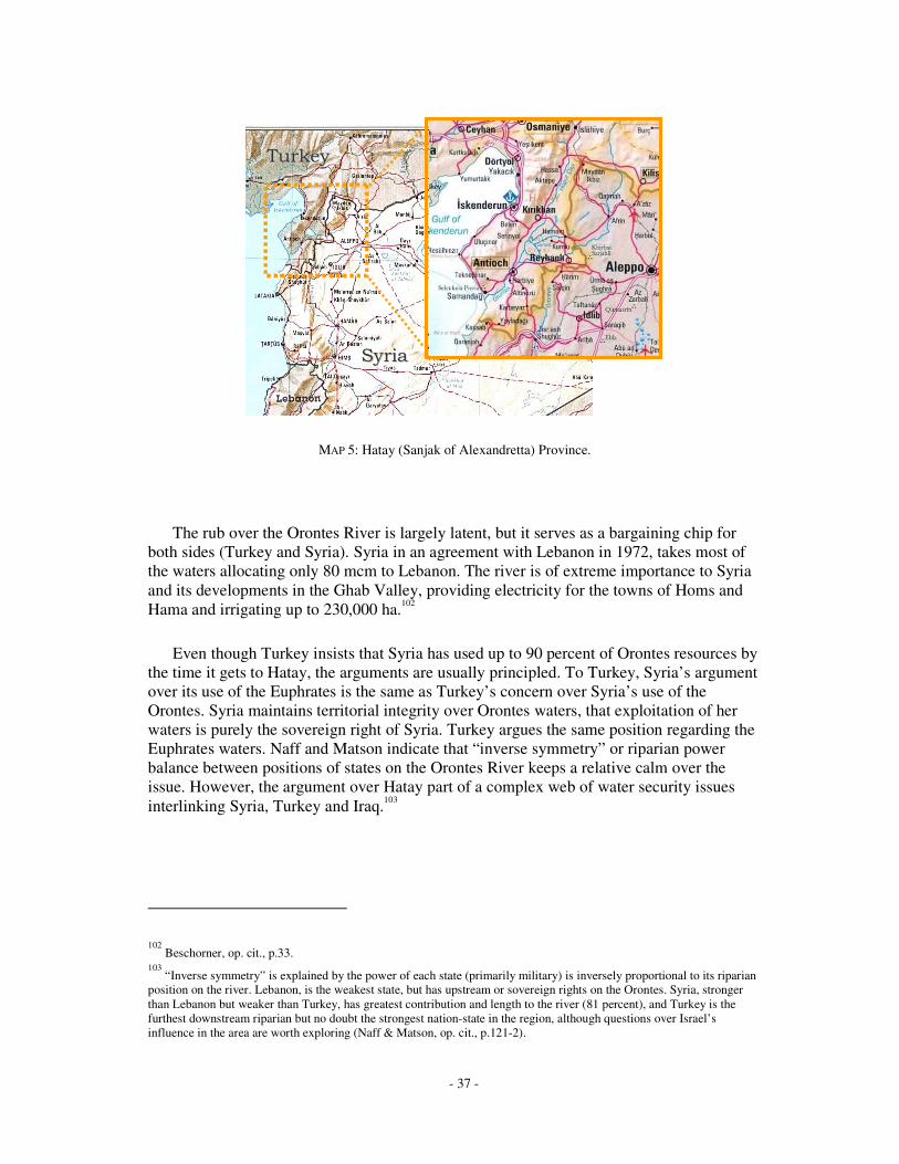
- 37 -
&'���&'���
���( '���( '
&'���&'���
���( '���( '
MAP 5: Hatay (Sanjak of Alexandretta) Province.
The rub over the Orontes River is largely latent, but it serves as a bargaining chip for both sides (Turkey and Syria). Syria in an agreement with Lebanon in 1972, takes most of the waters allocating only 80 mcm to Lebanon. The river is of extreme importance to Syria and its developments in the Ghab Valley, providing electricity for the towns of Homs and Hama and irrigating up to 230,000 ha.102
Even though Turkey insists that Syria has used up to 90 percent of Orontes resources by the time it gets to Hatay, the arguments are usually principled. To Turkey, Syria’s argument over its use of the Euphrates is the same as Turkey’s concern over Syria’s use of the Orontes. Syria maintains territorial integrity over Orontes waters, that exploitation of her waters is purely the sovereign right of Syria. Turkey argues the same position regarding the Euphrates waters. Naff and Matson indicate that “inverse symmetry” or riparian power balance between positions of states on the Orontes River keeps a relative calm over the issue. However, the argument over Hatay part of a complex web of water security issues interlinking Syria, Turkey and Iraq.103
102 Beschorner, op. cit., p.33.
103 “Inverse symmetry” is explained by the power of each state (primarily military) is inversely proportional to its riparian
position on the river. Lebanon, is the weakest state, but has upstream or sovereign rights on the Orontes. Syria, stronger than Lebanon but weaker than Turkey, has greatest contribution and length to the river (81 percent), and Turkey is the furthest downstream riparian but no doubt the strongest nation-state in the region, although questions over Israel’s influence in the area are worth exploring (Naff & Matson, op. cit., p.121-2).

- 38 -
��&����%��������� ���
Ancient Mesopotamia and the Hydraulic Culture
Evidence of the most ancient and extensive waterworks in the world are found in lower Mesopotamia going back to 6000 B.C.104 Forming a patchwork of tangled canals, seemingly without reason, they are the result of the labours of many diligent and ingenious societies over a period of millennia. The most ancient canal, the great Nahrawan, built in the sixth century, was 30 meters wide and over 300 long. Mesopotamia's plentiful water resources and lush river valleys served as the basis for the civilizing trend begun at Sumer and preserved by rulers such as Hammurabi (1792-1750 B.C.), Cyrus (550-530 B.C.), Darius (520-485 B.C.), Alexander (336-323 B.C.), and the Abbasids (750-1258). The ancient cities of Sumer, Babylon, and Assyria all were located in what is now Iraq. Sumer is the ancient name for southern Mesopotamia, and it is widely agreed that the Sumerians, who were highly ingenious, invented the first form of irrigation to improve agricultural production on the lower Mesopotamian Plain. They also devised the first written communication, or handwriting. The birthplace of the prophet Abraham comes from the Sumerian city of Ur.105
By 754 B.C., the Assyrians had settled in the upper valley where they founded a city known today as Baghdad. The Assyrians used the rivers, especially the Euphrates, for transporting grain while also deepening and straightening many of the existing canals. Ancient Mesopotamia was definitely a hydraulic culture, and some have term it an “Oriental despotism,” however it seems most bureaucratic and overt authoritarian control over water works was noticeable by its absence.106 Nevertheless, regardless of its productive wealth and prosperity for many millennia, Mesopotamia saw wave after wave of conflict, most notably the invasion of the Mongols in the thirteenth century, destroying a majority of elaborate canals systems built centuries before. Since the Mongol invasions until the nineteenth century, Mesopotamia has moved toward a more rural society, creating a huge dependence on irrigated agriculture for its survival.
Water security in Iraq has many dimensions, the first of which looks at land use policies and the ever-increasing problem of salinity. This is followed by Iraqi water resources and withdrawals and how they are impacted by upstream depletions. Iraq’s economy is discussed next, paying special attention to food security, and Iraq’s relationship with the International community. Iraq’s political rivalry with Syria ends the section. Note that the relationship between Kurds in northern Iraq is not discussed. This is intentional, as a high level of cooperation between Iraq and Turkey to suppress Kurdish movements resulted in little apparent links to water issues, although no doubt local rivalries over water did exist.
104 See MAP 6: Ancient watercourses on the lower Diyala plain. Adams, Robert McC., 1981, Heartland of Cities, pp.48-9.
105 US Library of Congress – Country Studies, 1Up Travel.com portal, 2003a, Country Study & A Country Guide, Country
Study & Country Guide for Iraq, Iraq, Ancient Mesopotamia, (www.1uptravel.com/country-guide-study/iraq). 106
Adams, Robert McC., 1981, Heartland of Cities, pp.242-8.

- 39 -
MAP 6: Ancient watercourses on the lower Diyala plain
Tigris River
Euphrates River
Baghdad 100 km

- 40 -
Priorities Over Land and Water Quality
The Iraqi government has spent billions of Iraqi dinars on hydrological infrastructure. An estimated US $4 billion was spent between 1975 and 1985, mostly on capital investments such as dams and barrages. Significant factors underpinning the government’s policy on development include: fear of losing water from upstream riparians, excessive military spending, disjointed water works projects and lack of water conservation.
Saddam’s contemptuous relationship between Iraq and its neighbours, particularly Turkey and Iran, contributed to the focus on installing extensive hydrological infrastructures. Iraq’s water security is not unconnected to Iraq’s military insecurity, as evidenced by huge levels of spending during the 1970s and 1980s, accounting for 19, 39 and over 70 percent of GDP 1970, 1975 and the 1980s, respectively.107 The increase in military spending on coincided with beginning of Saddam Hussein’s regime. Corresponding lack of investment in water delivery systems and extension work with farmers relates directly to ineffective water management, resulting in persistent leaking canals adding to salinity problems that already exist. Efficiency estimates range from 30-40 percent to 60 percent, at best.108 Funding for conservation programs such as effective water use, prevention of flood irrigation and subsidized credits for tile drainage are nonexistent until recently, previously limited funded from the UNDP, and recently stalled due to the current lack of security in Iraq.
Salinity is the number one problem facing Iraqi farmers, once access to water is achieved. Inadequate drainage causes farmland to waterlog, and more seriously, forces groundwater to intrude the surface, threatening fertile soils and crop roots with lethal amounts of chlorides. Despite construction of the Main Outfall Drain (Saddam River, or Third River) in the early 1990s to drain and reclaim land for agricultural use, less than three mha are still in use. The project has also been a ecological, demographic and ethnic nightmare, draining the marshes in southern Iraq indigenous to local Shiite Muslims called the Madan, displacing thousands from their historic water culture.109 Unfortunately, recent attempts to improve salinity and reclaim land are dubious, with over half of 750,000 ha of land reclaimed in 1989 returned to unusable status.110 Salinity issues are not only contaminating land, they are affecting groundwater and water quality in the Euphrates and Tigris Rivers. Yet water quality is
107 Abbas Alnasrawi, 2001, “Iraq: economic sanctions and consequences, 1990-2000”, Third World Quarterly, 22 (2):
pp.206-7. 108
Abdullah A. Jaradat, October 2002, Agriculture in Iraq: Resources, Potentials, Constraints, and Research Needs and Priorities, Research paper submitted to the Department of State-Middle East Working Group on Agriculture, Morris, MN: NCSC Research Lab, ARS-USDA (Agricultural Research Service-US Department of Agriculture, pp.30-2; Kliot, op. cit., 146; Kibaro�lu, op. cit., p.210-15. 109
For a superb report on reclamation of the marshlands, see UNEP, 2001, Partow, H., The Mesopotamian Marshlands: Demise of an Ecosystem, Early Warning and Assessment Technical Report, UNEP, DEWA, TR.01-3 Rev.1. Figures as of 1993. In 1992, the Iraqi government built a huge watercourse, a system to drain waterlogged fields, improve water quality and soil salinity, called the “Third River.” It collects water from more than 1.5 million ha (Jaradat, op. cit., pp.28-9). 110
Jaradat, op. cit., p.31.

- 41 -
becoming less and less controllable from upstream sources, as demands from Turkey and Iran multiply.111
Water Quality
Growing demands for irrigation by both Syria and Turkey ultimately affect the amount and quality of water Iraq receives from the Tigris and Euphrates rivers. Higher sedimentation rates and river salinity have reduced flowrates and necessitate major changes in water use policies. A lack of effective coordination between countries prevents joint planning in water development strategies, or an establishment of three-way water quality targets or even cooperative hydrological flow schemes. Water quality is still somewhat good down to Ramadi, where salinity levels reach 250 to 500 mg of chlorides per litre, which will render water unsuitable for irrigating some crops. Estimates are that levels reach over 600 mg near Basrah, and may be high as 5,000 mg per litre in the Shatt al-Arab River. This subject is touched on again in the last chapter, as it could be an explosive factor in the future due to upstream use of the Euphrates by Turkey and Syria, and to a lesser degree, the Tigris.
Iraq’s Water Resources
Most of Iraq receives less than 150 mm of rainfall a year or 65.7 km3, most of which runs off in the Tigris River. The bulk of Iraq’s water resources come the Euphrates and Tigris, both of which originate in Turkey. Ninety-two percent of Iraq’s water withdrawal is for agriculture and three percent for domestic use;112 consequently, management of these two rivers has clearly been the highest priority of agricultural development strategies, seeing a number of dams and barrages built during the 1970s, 1980s and into the 1990s, creating large storage lakes for irrigation use.113 These projects are ambitious and widely seen as successful from a hydrological perspective, but getting water to the fields efficiently is not straightforward. Most of Iraq’s agricultural land, except northern fields, lies dead flat, creating yet another major obstacle to successful farming, drainage.114 In addition, mean temperatures in Iraq can run in the excess of 50° Celsius, forcing huge evapotranspiration and evaporation rates. Not only does this accelerate water salination in the Mesopotamian
111 Geographical Magazine, see article by Mohmood Clor, 1988, “A Land of Milk and Honey…and Salt,” 60 (November
1988): pp.34-37. 112
Jaradat, op. cit., Sec.3.12, p.30. 113
Beaumont & McLochlan, op. cit., Tables 10.4 and 10.6, p.194,196; Jaradat, op. cit., p.28; US Library of Congress – Country Studies, 1Up Travel.com portal, 2003b, Country Study & A Country Guide, Country Study & Country Guide for Iraq, Iraq, Water Resources, (www.1uptravel.com/country-guide-study/iraq). 114
Baghdad itself is only 32m above sea level (Jaradat, op. cit., p.32).

- 42 -
Plains, but it also account for up to 10 percent of water storage losses throughout Iraq’s vast and complex series of reservoirs and man-made lakes.115
As mentioned in Chapter I, the Euphrates and Tigris constitute 40 and 54 percent of total basin drainage area, respectively. Average surface flows into Iraq provide around 28.5 bcm from the Euphrates and 50.0 bcm from the Tigris, subject to seasonal variations, which can vary up to 30 percent.116 However, Iraq only contributes around 13 percent of Tigris discharge, and nothing to the Euphrates, and therefore has capitalised on the near 2,500 km of river from both the Euphrates and Tigris running through the country, building dams, barrages and reservoirs in order to store water irrigation, domestic uses and flood control.117 Tributaries of the Tigris are an important contributor to Iraqi surface resources.118 Groundwater resources are estimated at 1.2 bcm.119
Iraq’s total actual renewable water resources (ARWR) then works out to be 75.5 bcm, 46.6 percent internal renewable resources (35.2 bcm) and the remaining 40.3 bcm from external sources such as the Euphrates and Tigris. However, Iraq dam storage capability is 50.2 bcm, but due to evaporation, Iraq loses 10 percent to that, or 5 bcm per year.120 The discrepancy between internal and external renewable water supply, or dependency ratio of 53 percent, is at the heart of Iraqi fears that Turkey’s GAP projects will reduce flows to a point where Iraqi irrigation schemes will become redundant. Due to GAP, by 2040 Iraq’s ARWR could reduce to 51 bcm.
115 Kliot, op. cit., p.122.
116 Jaradat, op. cit., pp.26-8; Kliot, op. cit., 144.
117 See Chapter 1. On the Tigris, 13% of 52 bcm equals 6.57 km3, only 10% of the average precipitation in the country.
The mountainous region of northeastern Iraq or Kurdistan can see up to 1,500 mm or rainfall annually. 118
Turkey contributes 65% of flow, Iran 22%. Tributaries and their contributions include the Greater Zab, originating in Turkey and controlled by Bakhma dam and adds 13.18 bcm, the Lesser Zab, originating in Iran with the Dokan dam (6.8 km3)in Iraq contributes 7.17 bcm, the al-Adhaim (Great River) adds 0.79 bcm, the Diyala, originating in Iran and contains the Darbandikhan dam contributes 5.74 bcm, the Nahr al-Tib, Dewarege and Shehabi rivers all which originate in Iran and contribute a combined 1.0 bcm, and finally the Al-Karkha, mainly runs through Iran but brings 6.3 bcm to the Tigris during the dry season, and to the Hawr Al Hawiza during the flood season, flushing the marshlands with saline water. The Karun river, also originating in Iran adds 24.7 bcm to the Shatt Al-Arab. Total tributaries, excluding the Karun, add 34 bcm to the Tigris, and roughly 14 km3 of storage. The Karun is excluded because it empties into the Shatt directly from Iran, a border that is still in dispute. The Shatt Al-Arab is too saline for most irrigation projects. (Jaradat, op. cit., pp.26-8). 119
See FIGURE 7: Iraqi Water Supply (various yrs to date). Kliot, op. cit., p.143; raw data taken from UNEP, GEO Data Portal, Sept 09, 2003, (http://geodata.grid.unep.ch). 120
Hillel, op. cit., p.103.

- 43 -
FIGURE 7: Iraqi Water Supply (various yrs to date)
Recent Water Works in Iraq
Barrages, reservoirs, lakes and canals are extensive in Iraq. The most significant off-river reservoirs are the Habbaniya, Abu-Dibbis (Ar-Raz�zah) and Lake Tharthar. Both Habbaniya and Abu-Dibbis Lakes were built in ancient times and were designed to control flooding on the Euphrates, with a combined storage potential of 46.0 km3. Lake Tharthar was built in 1950 to prevent flooding from the Tigris. It effectively diverts water from the Tigris River to the Tharthar depression, linking via a canal to the Euphrates River. This project and resulting functionality is a source of contention for Turkey and Iraq. Turkey maintains that this links the Tigris and Euphrates river basin, thus determining downstream water budgets holistically. Iraq does not maintain this position for fear that the waters on the Euphrates would suffer, losing irrigated land on the banks north of Al-Ramadi. Taking into account Turkish and Syrian withdrawals on the Euphrates, Iraq has more water that is available from the Tigris River.
Major dams in Iraq provide most of major irrigation works in the country. The Haditha dam (renamed Q�disiyah) on the Euphrates has a 6.4 km3 storage capacity and irrigates some one million hectares of land. Likewise, the Tigris irrigates an estimated 2.2 million ha, most coming from Mosul (Saddam) dam (10.7 km3). A number of other dams, mostly on the Tigris add another 13.7 km3 of water storage. Total on-river storage for the Euphrates and Tigris rivers is approximately 8.2 and 42.0 km3, respectively.121
121 Dams on the Tigris rivers during the 1970s had a storage capacity of 13.7 km3, and projects during the 1980s including
an additional dam on the Tigris (11.1 km3), the Qadisiah dam on the Euphrates (8.2 km3), the Bakham on the upper Zab (17.1 km3), the Badush on the Tigris (0.5 km3) and several other desert dam totalling 0.5 km3. Al-Adom on the Tigris is

- 44 -
However, Bakham dam was completely destroyed during the Gulf War, and bombing by coalition forces caused extensive damage to Iraqi infrastructure. Other dams that were destroyed include the Darbandikhan (50%), Dokan and Haditha (75%), where the Ramadi barrage and Samarra dams were completely knocked out. Other water targets that were hit were pumping installations, water purification plants and power stations, severely affecting food production and access to safe drinking water.122 Crops for the following year were down 50 percent and follow years suffered to due to shortages of inputs. A notable tragedy was the failure of the national date crop, a source of national pride, due to raw sewage dumped into the Tigris.123
Iraqi Water Withdrawals
Map 7 gives an idea of the irrigation projects and withdrawals from the Mesopotamian Plain in the early 1990s.124 Agriculture is the biggest user of water, soaking up nearly 39.4 bcm per year in Iraq. Official total irrigated area in Iraq is estimated to be near 3.5 mha, but Jaradat suggests that only 1.94 mha were actually being irrigated in 1993, 220,000 ha of that by groundwater. Figures indicate that the actual number is probably closer to 3 mha, 2 mha on the Euphrates and 1 mha on the Tigris.125 Iraq is currently using more than 15 bcm from the Euphrates for irrigation, and 32 bcm on the Tigris. By 2040, they predict withdrawals will increase to 16 and 40 bcm for the two rivers, respectively.
currently under construction with storage capacity of 3.8 km3. In 1988, barrages and dams were located at Samarra, Dukan, Darband, and Khan on the Tigris and Habbaniyah on the Euphrates. Two new dams on the Tigris at Mosul and Al Hadithah, named respectively the Saddam and Al Qadisiyah, were on the verge of completion in 1988. Furthermore, a Chinese-Brazilian joint venture was constructing a US $2 billion dam on the Great Zab River, a Tigris tributary in northeastern Iraq. Additional dams were planned for Badush and Fathah, both on the Tigris. In Hindiyah on the Euphrates and in Ash Shinafiyah on the Euphrates, Chinese contractors were building a series of barrages. (US Library of Congress – Country Studies, Iraq, Water Resources, op. cit.). 122
Before the Gulf War, barrages or dam reservoirs existed at Samarra, Dukan, Darband, and Khan on the Tigris and Habbaniyah on the Euphrates. Two new dams on the Tigris at Mosul and Al Hadithah, named respectively the Saddam and Al Qadisiyah, were on the verge of completion in 1988. Furthermore, a Chinese-Brazilian joint venture was constructing a US$2 billion dam on the Great Zab River, a Tigris tributary in northeastern Iraq. Additional dams were planned for Badush and Fathah, both on the Tigris. In Hindiyah on the Euphrates and in Ash Shinafiyah on the Euphrates, Chinese contractors were building a series of barrages” (US Library of Congress – Country Studies, Water Resources, op. cit.). 123
Beschorner, op. cit., p.36. 124
See MAP 7: sourced from Kliot, op. cit., p.145. 125
My figures based on Kolar and Kliot’s water usage of 13,300 to 15,900 m3/ha estimates, including losses (Kliot, Ibid). This is based on a 70% water-to-field efficiency. Iraq’s efficiency is probably nowhere near that figure, but probably closer to 50%.

- 45 -
MAP 7: Irrigation Projects and Withdrawals in Iraq.
Domestic and industrial withdrawals are estimated to use approximately 1.5 and 3.0 bcm, respectively, and predicted to increase to rise to 2.5 and 3.6 bcm by 2040. Total withdrawal currently then figures to some 50 bcm, however by 2040 it jumps to near 62 bcm.
These numbers are staggering, particularly when considering use verses supplies.126 Currently there is a surplus of 28.9 bcm, however by 2040 there is a deficit of over 20 billion cubic meters of water annually. This is nearly equal to the 18.6 bcm reduction expected due to Turkish and Syrian depletions on the Euphrates.
126 See FIGURE 8: Iraqi Water Balance (1990, 2040). Raw data source Kliot, op. cit., p.144, Kibaro�lu, op. cit., p.209.

- 46 -
10.6
40.5
-16.0
-40.0
-9.6
-2.5
-3.6
29.0
52.6
-15.0
-32.0
-1.2
-1.5
-3.0
28.9
-20.6
Euphrates
Tigris
Irrig on Euphrates
Irrig on Tigris
Evaporation
Domestic
Industry
1990
2040
Water Balance
1990
2040Dem
and
Supp
ly
FIGURE 8: Iraqi Water Balance 1990, 2040 (bcm)
Agriculture and Food Security in Iraq
The state of agriculture in Iraq closely reflects the region in which it is located, with the possible exception of Turkey and Sudan. Agriculture contributed to over 70 percent of Iraq’s GDP in the 1920s, steadily decreased to 42 percent in 1981, 18 percent in 1990 and a mere 6 percent in 2001.127 The percentage of arable land in Iraq is approximately 20-30 percent of total land area or 11.5 million ha, of which only 8 million is usable for agriculture (17%), half of that cultivated (8.5%).128 Of cultivated lands, half is dry land, or rain-fed, the remainder irrigated.
At one time Iraq was self-sufficient in cereals, but over the last forty to fifty years, it has become a net importer of agricultural goods, importing up to 80 percent in the late 1980s.129 The shift was due to number of reasons: rapid shift to oil economy (and subsequent rising standard of living, including massive inflation), persistent drought, increased industrialization, migrations of farm workers to urban centres, population increase, reduction of government spending on agriculture, and loss of soil productivity in poorly
127 Jaradat, op. cit., Sec.1, p.8.
128 Production Estimates and Crop Assessment Division, USDA, Foreign Agricultural Service, January 16 2003, PECAD's
Weather and Vegetation Index Monitoring Analysis (http://www.fas.usda.gov/pecad/); “Drought Effects Briefing Notes”, FAO Representation in Iraq, FAO (1999), September 1999; “Special Report: FAO/WFP Food Supply and Nutrition Assessment Mission to Iraq”, FAO/WFP (1997), 3 October 1997. 129
See previous footnote. Beschorner, op. cit., p.35.

- 47 -
drained areas of the south. Not only history gives Iraq its hydraulic culture, over half rain-fed fields subject to hugely unpredictable precipitation schedules coupled with an arid climate made getting water to crops a vital endeavour. Of course, the largest contributor to Iraq’s failing self-sufficiency and increased water security complex is the brutal regime of Saddam Hussein. Nearly twenty years of war have ravaged Iraqi infrastructure, society and vital health indicators.
Iraq’s Economy and Relations with the International Community
The Gulf war and subsequent economic sanctions greatly injured Iraq’s GDP, reducing it by 75 percent. Iraq’s oil makes up over 61 percent of the country’s GDP, and 99.6 percent of foreign earnings, with proven reserves over 125 years. It is no wonder that cutting off oil supplies by 85 percent in 1991 had such a large impact on the Iraqi economy, not least the effects of war on society, and on water resources.130 The combination of all these and other factors left over a 53 percent food deficit in Iraq. Response by the Iraqi government was to increase food production, thus putting more stress on water resources in the country.
Food Production and Nutrition
Iraq did try to boost agricultural production during and after the sanction regime with some success; overall productive output rose over 500,000 tons from the late 1980s to mid 1990s. Farmers were told to crop every year and many left open gate valves flooding their fields for days, greatly increasing withdrawals for river water. However the meagre bounties where ultimately insufficient to meet the minimal nutritional needs of Iraq people, as drought and unstable agricultural production forced lower production figures for cereals such as wheat and barley.131 The reduction in cereal output severely affected calorie intake, going from an average of 3,372 Kcal/cap/day between 1984-1989 to as low as 2,268 Kcal/cap/day in 1993-1995.132 The oil-for-food program greatly improved food security in Iraq, albeit slightly. The program boosted the energy levels from 1,295 Kcal/caput/day to 2,030 Kcal/caput/day, still below the required levels for proper nutrition (2,100 Kcal/caput/day).133
130 FAO, “Special Report: FAO/WFP Food Supply and Nutrition Assessment Mission to Iraq”, 3 October 1997, Global
Information and Early Warning System on Food and Agriculture, World Food Programme, FAO, Rome, (http://www.fao.org/WAICENT/faoinfo/economic/giews/english/alertes/srirq997.htm); Beschorner, op. cit., p.35. 131
Production decreases in percent. Cereals (-18), eggs (-70), meat (-50), poultry (-75) and sugar beet (-90). The production of other vital products, such as eggs, sugar beet, and meats such as beef and poultry drastically reduced -50% and -75%, respectively (Ibid). 132
“Special Report: FAO/WFP”, op. cit., Sec.5. Units are kilocalorie per person/day. 133
See FIGURE 9: Calorie Intake for Turkey, Syria and Iraq. “Special Report: FAO/WFP”, op. cit., Sec.5.1.

- 48 -
FIGURE 9: Calorie Intake per Capita for Turkey, Syria and Iraq
Ba’ath Party Rivalry with Syria
The Ba’ath party first came to power in Iraq in 1963 after overthrowing the Qassem regime. Three years later, the Syrian Ba’ath party came to power. Since 1968 and Saddam Hussein came to power, both parties claimed to be the leading ideological force in pan-Arabism – competing for Arab legitimacy. The Syrian regime, a much younger form of Ba’ath leadership, perceived Iraqi Ba’athism as a threat to their survival. These tensions made for an uncooperative climate between the two countries, and combined with the filling of Tabqa Dam in 1974-5, relations soured nearly to the point of full-scale military conflict. Interestingly, Turkey’s continued development on the Euphrates has brought Syria and Iraq together in protest. Filling Atatürk Dam in 1990 sparked Iraq and Syria to sign a treaty giving 58 percent of Euphrates flow to Iraq and 42 percent to Syria.134
Differences over security perceptions and political rivalries cause conflict of interest, and major water security clashes between Turkey, Syria and Iraq occurred in 1975 and 1990.
134 Lowi, Miriam, 1993, Water and Power: The Politics of a Scarce Resource in the Jordan River Basin, pp.58-9; Shultz,
A Hydropolitical Security Complex, op. cit., pp.110-1.

- 49 -
�$�����������%�������� ��� ������������������������������
Impounding at Turkey’s Keban Reservoir and Syria’s Lake Assad
Turkey’s building the Keban Dam in the late sixties finishing in the early seventies caused Syria considerable stress, particularly due to Syria’s Euphrates Valley Project. In 1964, Turkey pledged to release 350 m3/s from the Euphrates downstream to Syria, however the gesture did not appease Iraq, the furthest downstream riparian and most dependent (at that time) on Euphrates water. The first real crisis occurred in 1974 because of a number of negative factors affecting flow of the Euphrates. Rainfall was scarce that year, and both Turkey and Syria began impounding water on the Euphrates in order to fill reservoirs created by the completion of the Keban and Tabqa Dams, respectively. The amount of water needed to fill both the Keban reservoir (30 km3) and Lake Assad (11 km3) equated to roughly 16 months of Euphrates natural flow. Iraq anticipated that developments would affect their three million inhabitants on the upper part of the river, and protested when Turkey applied for funding of Keban Dam. The World Bank ended up funding the project, but only with a provision that a minimum flow of 450 m3/s was maintained downstream.
However, Iraq directed its wrath primarily at Syria during the 1974-5 incident. The Syrian project, unlike the Turkish one (only hydropower), would withdraw water for irrigation projects. In addition, Ba’ath party rivalries had climaxed between Baghdad and Damascus, the two regimes competing for pan-Arab influence in the Middle East and frequently accusing each other of hostile acts. When in the spring of 1975 Syria began filling Lake Assad, reducing Euphrates flow from 920 m3/s to 197 m3/s, and yearly from 15.3 bcm in 1973 to 9.4 bcm, Iraq went ballistic. Iraq claimed rights to 16.1 bcm from a 1965 World Bank figure based on Iraq agricultural potential, and accused Syria publicly in front of the Arab League of purposefully withholding Euphrates water for political reasons, leading to the destruction of 70 percent of her winter crop and threatening over three million Iraqi farmers who are dependent on the river for irrigation.135
The situation deteriorated quickly and Saudi Arabia, the Soviet Union and the Arab League stepped in to mediate. However, Syria and Iraq closed each others’ airspace, cancelled diplomatic and economic relations, revoked flights and moved troops to their common borders. Iraq even threatened to bomb the Tabqa Dam.136 Disaster was only averted when Syria finally gave in to a joint Soviet-Saudi proposal for sharing water on a “proportional basis,” releasing an extra 0.2 bcm of water from Tabqa Dam contingent on
135 Beshorner, op. cit., p.39-40; Shapland, op. cit., p.117; Elhance, op. cit., 142-3.
136 Gleick, Water and Conflict, op. cit., p.88, in Wolf, 2002, op. cit., p.157.

- 50 -
water reaching Syria from Turkey.137 Iraq continued to blame Syria for water shortages during the drought stricken 1980s, with no formal agreement having been reached, leaving the issue yet unresolved.138
The Filling Atatürk Reservoir – Agreements verses Downstream Effects
The other significant confrontation threatening water security of the region was the filling of Atatürk Dam in 1990. Scepticism between the three countries had already elevated and failures of the Joint Technical Committee (discussed in the final chapter) and efforts to link other security concerns to unprecedented levels between Turkey and Syria. Regardless of assurances by Turkey that it was doing the ‘right’ thing and send Syria at least 500 m3/s, reactions to any flow reductions on the Euphrates downstream were, to say the least, irate.
Turkey began assertively impounding water to fill the reservoir created by Atatürk Dam on January 13 1990. A concrete plug was used to shut off flow of the Euphrates for four weeks and begin filling the Atatürk reservoir.139 Syria and Iraq insisted in a Joint Technical Committee that two weeks was sufficient to begin impounding water, and again called for trilateral agreement of water quotas. Turkey stressed that the impounding was at a time (winter) when Syrian and Iraqi demands were at their lowest (flows are also low at this time, 500 m3/s in January or 20 percent of maximum flow, peaking at an average 2,550 m3/s in April).140 In retrospect, Turkey could be criticised for not choosing the most opportune time to impound water. However, these grievances are inconsequential with respect to the primary concerns between the upper and lower riparians.
Firstly, the Joint Technical Committee (JTC), set up in 1980 but not working until 1983, failed to provide a common and reliable source of data to all parties. The mandate of the committee was to share technical details between the parties thus creating a sense of openness and trust between Turkish, Syrian and Iraqi engineers, hydrologists and ministers. This immediately broke down during the crisis, creating a sense of ‘whom is to believe whom’ between affected riparians. The failings of the JTC are explored further in the following Chapter. This led to contradictory interpretations of the status of the1987 protocol. Syria and Iraq maintained that Turkey had breached the 500 m3/s agreement,
137 Much of the eventual mediation resulted from the Iran-Iraq Accord of 1975, which end ‘official’ Iranian for the
Kurdish rebellion in Iraq and raised Syrian fears that rival Ba’athists in would stir up things in Syria. (Morris, Mary E., 1997, “Water and Conflict in the Middle East: Threats and Opportunities,” Studies in Conflict and Terrorism, p.8-9). 138
Lowi, Miriam, 1993, Water and Power: The Politics of a Scarce Resource in the Jordan River Basin, pp.57-9; Hillel, op. cit., p.109. 139
Atatürk has a stored capacity of 48.7 km3, or over three years flow of the Euphrates below Atatürk Dam based on the Turkish-Syrian 1987 agreement (an average 500 m3/s = 15.8 bcm/yr). 140
Data calculated from Kolars & Mitchell, op. cit., Table 5.10, pp.105. Flowrates from the Euphrates River at Birecik estimate at 856 m3/s (26.990 bcm), and at the Turkish-Syrian border of approximately 869 m3/s (27.4 bcm). Thus, monthly variations, roughly equivalent to variations at Birecik (Ibid, Table 5.2, pp.90-1) give flows in January and February of 525 m3/s and 635 m3/s, respectively. This is less than 25% of the maximum flow in April and roughly 65% of the average flow over a 30-yr period (1937-1963).

- 51 -
while Turkey contends they maintained 500 m3/s annual flows. Turkey had agreed to increase flows from Keban and Karakaya upstream to maintain at least 750 m3/s during the period before impoundment. The Turkish government’s position is stated as:
“Before the impounding period, Turkey released more water than the commitment of 500 m3/s, which is undertaken by Turkey in accordance with the provisions of a Protocol, signed in 1987 with Syria. Turkey has thus created an opportunity for the downstream countries to accumulate this additional water in their own reservoirs. In this context 768 m3/s of flow has been released at the Turkey-Syria border within the period starting on 23 November 1989 and ending at the beginning of the impounding process on 13 January 1990. Water coming from the tributaries which join the Euphrates between the Atatürk Dam and the Turkish-Syrian border has also continued to flow into Syria in the slice of time between 13 January and 12 February 1990, covering the impounding period. Thus, the total water amount crossing the border between 23 November 1989 and 12 February 1990 has amounted to 3.6 bm3, corresponding to an average value of 509 m3/s. Therefore, even in this period of 82 days, which also covers the one month impounding period- Syria has received more water than the committed quantity of 500 m3/s.”141
The data does suggest that Turkey had in at least literally kept its end of the bargain by delivering 500 m3/s annually, but monthly figures show they breached the agreement.
In question is Turkey’s unilateral method of notification of its plans on Atatürk, notification only made barely a year in advance of the impounding and without much due concern of Syria and Iraq. Turkey also underestimated the tributary flow that would sustain the Euphrates flow into Syria during the one-month impoundment. Initially they had said that over 120 m3/s would be flowing into the Euphrates from the Nizip tributary and two other smaller ones, but in reality, the natural flows from these streams were less than 60 m3/s or at most 0.154 bcm.142 This flowrate is under the minimum required to keep the river bottom biologically active and caused severe damage to irrigation on both riverbanks in Syria and Iraq, as well as power loss at Tabqa Dam. Nevertheless, Turkey still maintains that they could have performed the impounding differently causing more damage downstream, but did not out of concern for their neighbours.143
141 Republic of Turkey, Ministry of Foreign Affairs, Foreign Policy, Water Issues Between Turkey, Syria and Iraq, “The
Water Problem in the Middle East: Water Disputes in the Euphrates-Tigris Basin,” Para. i) Objections Directed Towards the Impounding of the Atatürk Dam, (http://www.mfa.gov.tr/grupa/ad/adg/adgb/Chap1c.htm). 142
As claimed by the Ministry of Foreign Affairs, Ibid. No independent source was found with flow measurements below Atatürk Dam during that period. The figure of 60 m3/s is the authors calculation based on DS�’s data of stream flow below Atatürk during that period (Ibid) and a reversal of the figures based on the claim that Turkey maintained flow over the entire period of 509 m3/s. Given no (0.0 m3/s) flow in tributaries below Atatürk during that month, which is not entirely unbelievable, as the Nizip is a small tributary at best, DS�’s figure would be 487 m3/s, which strangely enough is Syria’s official figure (Ministry of Irrigation in Syria, “Average monthly discharge of the Euphrates river at Jarablus – Syria,” Damascus, 1999, cited in The Ilisu Campaign, KHRP and the Corner House, October 2002, Downstream impacts of Turkish Dam Construction in Syria and Iraq: Joint Report of Fact-Finding Mission to Syria and Iraq, 02/G, (www.khrp.org/publish/list02.htm), pp.21). 143
The Turkish government goes on to say, “Water in the Atatürk Dam has reached the level of 15 bm3 during the January 1990-September 1991 period. In the same period 27 bm3 of water has been released to the downstream riparian countries

- 52 -
Secondly, differences in technical details did nothing to relieve the damage done from reduced flows and lost power production from Syria’s Tabqa Dam. Both Syria and Iraq called upon the Arab League states to unite against Turkey on the GAP issue, issuing statements threatening to take legal action for harm done and to pay compensation, in addition to boycotting British, French, German and Belgian companies for participating on dam works. Design of the dam prohibits low reservoir levels for hydroelectric production. Syria’s domestic water supply to Aleppo also pulls from Lake Assad in a similar fashion, which was interrupted during the incident.144
The Atatürk incident put a finger in a sore spot that had been blistering for some time, and ultimately was responsible for cessation of trilateral talks and disbanding of the Joint Technical Committee between the three states. Other factors aggravated the situation, such as persistent drought,145 which left Lake Assad below full capacity, inefficient water delivery systems operating in Syria, and flagrant statements by the Turkey’s President, Turgut Özal in 1989, pre-empting the restriction of Euphrates flow as a ‘water weapon.’ On 2 October 1989, Özal warned Turkish Parliament that Euphrates water to might be “cut off” if Kurdish activities are not curbed by Syria.146 Coincidentally, the comments were made just after Syrian MiGs shot down a survey plane in the Hatay Province killing five people. Syria claimed the plane was spying on Syrian water works. Moreover, PKK insurgents began operations in the Hatay Province in the early 1990s.
Turkish officials were quick to justify Özal’s outburst as “for internal consumption” and that Turkey would never use water as a political weapon. However, in 1990, Euphrates waters were consequently “cut off” albeit necessary; the warring words were echoed by actions. After the Atatürk impoundment, Prime Minister Süleyman Demirel echoed sediments expressed by Özal in apparent Turkish confidence in 1992 at a news conference in Istanbul,
on the basis of 500 m3/s. As these figures indicate, Turkey could have long before concluded the filling of the dam, if it had completely cut water flow to its southern neighbours. Not opting for such a course of action is a proof of Turkey's good intentions and of its sensitivity not to cause damage to its neighbours.” (Ibid).�144
By design Tabqa Dam, built by Soviet designers, works best when Lake Assad is filled to full capacity, then holding 11 km3, due to the high positioning of penstocks that feed its eight massive 110 MW turbines. The placement of the penstocks was a trade-off between power and reservoir storage. The higher the penstocks, the more hydropower (water above the generators is termed ‘head’). However, the design becomes susceptible to reductions in water levels, laying belief to the claim that hydroelectric production diminished significantly, if not completely halted, during the filling of Atatürk, in which the water level in Lake Assad dropped more than three meters. 145
Reports by a Turkish source on 14 December 1989 indicated, “reservoirs in northeastern Iraq are full but Syria’s main Tabqa Dam has 8 bcm of empty space because of a summer drought.” Source by Transboundary Freshwater Dispute Database, September 2003, International Water Events Database: 1948-1999, Oregon State University, Department of Geosciences, Aaron T. Wolf, (http://ocid.nacse.org/cgi-bin/qml/tfdd/eventsearch.qml). 146
Ibid. Turkish President Turgut Özal speaking to Pariament, 2 October 1989.

- 53 -
“This is a matter of sovereignty. This is our land. We have the right to do anything we like. The water resources are Turkey’s. The oil resources are theirs. We do not say we share their oil resources. They cannot say they share our water resources.”147
Turkey’s stance went on to stress that they were indeed abiding by the 1987 temporary agreement to supply Syria with 500 m3/s as evidenced by the data, and that waters were being allocated (not shared) to downstream riparians in a rational and timely manner. Turkish Foreign Minister Hikmet Çetin stressed that both countries had an interest in shared security at their common borders and reasonable water policy, but criticised Damascus for its continued support of the PKK in the Becca Valley in Lebanon, and reiterated that Syria’s claim that the Euphrates was a international river is in complete contradiction with its policy on the Orontes River, of which Syria withdraws 90 percent of Orontes natural flow.
Despite Syria’s official complaints to the Arab League and attempts to link the issue with the Middle East peace process, relations with Turkey remain strained. Other reported reductions in Euphrates flow below the agreed 500 m3/s occurred in 1993 prior to the construction of Birecik Dam just north of the Turkish-Syrian border. Turkey turned off the tap during the Muslim Feast of the Sacrifice in June, reducing the Euphrates flow to a mere 170 m3/s. During a visit in 1998 to Hatay by General Ates, Chief of the Turkish Army, he exclaimed “our patience is exhausted” just before sending 10,000 troops to the border of Syria to bomb PKK bases in Syria and Lebanon, as issue directly linked to Euphrates water.148 Tensions rose again in 2000 when Turkey informed Syria that it could not provide a minimum 500 m3/s due to drought conditions, spurring an all too familiar flurry of diplomatic notes between Damascus and Ankara.149
Although the events surrounding the filling of Atatürk were contentious, a positive result did emerge from the crisis. Syria signed a bilateral treaty with Iraq to ensure an equitable division of Euphrates flow between the two states. In 1990, Syria pledged in form of a formal Protocol to keep 42 percent of Euphrates flow and pass on the remaining 58 percent to Iraq. The two states, normally at loggerheads with each other secured their end of water security on the Euphrates, possibly hoping to put the preverbal ‘pie in the face’ to Turkey. The protocol ended a long period of abrasive relations between Syria and Iraq.
147 Ibid. Prime Minister Süleyman Demirel, news conference in Istanbul, 24 July 1992.
148 Adams, Water and Security Policy, op. cit., p.49.
149 The Ilisu Campaign, KHRP and the Corner House, October 2002, Downstream impacts of Turkish Dam Construction
in Syria and Iraq: Joint Report of Fact-Finding Mission to Syria and Iraq, 02/G, (www.khrp.org/publish/list02.htm), pp.22-3.

- 54 -
$������ ����� ���
Syria and Iraq’s water security concerns are similar. They both have acquired existing or historic rights, and join in protest against Turkey’s massive development plans for utilizing the Euphrates and Tigris Rivers. Syria’s water security (north of Damascus) depends primarily on the Euphrates River, where a majority of its water policy for domestic, food security and irrigation projects are utilised. Syria’s hydrodevelopment has suffered due to ineffective planning, fractional outputs, huge losses and poor efficiencies. Of critical importance to the city of Aleppo is hydroelectric power and domestic water supply taken from Lake Assad on the Euphrates River. More alarming, Syria stands to lose up to 40 percent of flow on the Euphrates if Turkey implements all its GAP plans, and has directly (though not admittedly) linked support of the PKK and other rebel groups to its demands for Euphrates water. Syria’s policy is hypocritical; claiming rights in the Hatay Province and dominating withdrawals from the Orontes River but demanding that Turkey not do the same on the Euphrates. However, Turkey’s water dependency pales in contrast to Syria, arriving at less than 1 percent compared to Syria’s 83 percent. Iraqi water security places an even greater emphasis on surface water and stands to lose up to 80 percent of natural flow from the Euphrates and 50 percent on the Tigris due to GAP, leaving a 20 bcm deficit by 2020 (equivalent to 67 percent of the Euphrates natural flow). Iraq is in the worst position, having been devastated by 20 years of interstate war and international sanctions; it has little political advantage to link to its water security. While Iraq has additional water from the Tigris, it usage rate per capita is the highest in the region, leaving it highly susceptible to quantity and quality reductions upstream and attracting widespread criticism for wasteful and inefficient practises. Culturally and environmentally, Iraq is in a sensitive position. Both the Mesopotamian and Diyalian Plains have been under irrigation for thousands of years, and the hydraulic cultures extend all the way to the Gulf via the Hawr al Hammer Marshlands and the Madan Arabs. However, Turkey’s military dominates Syria and Iraq, and although recent US influence in Iraq is altering the power balance, both Syria and Iraq are forced to lean heavily on toothless international watercourse law to assert their water rights.
Past conflicts between riparian states point to a genuine lack of trust between governments, resulting in exaggerated water demands and the solidifying of a regional resource dilemma over water, although all three riparians are relatively water rich compared with other Middle Eastern states. Disputes over the filling of Lake Assad and Atatürk Reservoir, as well as others, have led to disintegration of technical and political cooperative structures and have increased tensions between all sides. These failures to cooperate have also demonstrated a general disregard for ecological integrity of the both rivers, leaving little hope of realising a sustainable tripartite development scheme on the basin without outside involvement.

- 55 -
� ����������������������������������������������
������������ ����� ������������������
This chapter investigates the connection between water scarcity and conflict in the Middle East and its affects on a possible cooperative framework between Turkey, Syria and Iraq. Middle Eastern water scarcity effect on conflict is discussed first, followed by a wider view on traditional state security. This point leads to the question of widening traditional security to include environmental concerns, in particular water security and a river ethic. Attempted efforts at cooperation between riparian are investigated, leading to a look at the efficacy of international treaty laws in the context of water security. Finally, the principle of equitable and reasonable use is applied to the Euphrates-Tigris basin, including water security as a variable.
��� ������� ��� ��$��� ����������
The combination of increasing populations and fixed water supply results in decreasing water available per capita. Gleick predicts that by 2025 over 30 countries will be unable to provide as least 1,000 m3 per person per year, a figure regarded as a minimum necessary for an adequate quality of life in a moderately developed country, and 19 will be unable to provide even 500 m3 per person per year.150 What is precipitating these alarming trends?
A number of factors are contributing, but primarily the Middle East is suffering from a combination of wasteful and ineffective water use, unabated population pressure and geopolitical water availability disparities. Worldwide in 2000, agriculture accounted for some two-thirds of total freshwater withdrawal, and 86 percent of its consumption.151 Currently Turkey uses 74 percent of water for agriculture, with plans to increase it to 85 percent, half coming from the Euphrates and Tigris rivers doubling Turkey’s irrigated land. In Syria and Iraq, 95 percent of water withdrawals go for agriculture, combined with population growths over 3.5 percent and with accompanying needs growing at alarming rates, the oncoming clash between needs verses wants in approaching quickly. Nation-states, some new and others ancient have to adapt to an increasingly challenging set of preconditions and development constraints. Often their economies are failing to adapt to these rapid changes. Water conflicts are occurring in many places: India and Bangladesh, Slovakia and Hungary, Israel and its neighbours (including Syria again), Egypt and Ethiopia, the US and Mexico, and others. Water shortages are replacing oil as the source of conflicts. What is different about the Middle East? Why is water such a contentious issue?
150 Ibid.
151 UNEP, Vital Water Graphics, op. cit.

- 56 -
First, water is not a plentiful resource in the Middle East, the Arid Middle East that is. Actual renewable water resources (ARWR) for the Arid Middle East (AME) are only 600 m3 ppy (per person per year), the highest being Syria with 1,791 m3 ppy and dropping as low as 13 m3 ppy in Kuwait.152 Figures for Turkey and Iraq both show massive amounts of water per capita in comparison, giving 2,967 and 3,688 m3 ppy, respectively.153 The figures show a huge disparity between the water scarce AME and water rich Turkey, Iraq, and Iran, although with exception of Iraq, the three have the largest populations in the Middle East. Why is there conflict between such water ‘rich’ countries in a water scarce region?154
FIGURE 10: Water use per capita for Turkey, Syria and Iraq
Second, over 50 percent of populations of the Middle East (and North Africa) depend on rivers that transverse an international boundary before reaching them.155 Two-thirds of all Arabic speaking people in the Middle East rely on water from rivers flowing to them from non-Arabic speaking countries, 24 percent have no rivers and depend on diminishing wells or expensive desalinised water from the sea.156 Given nearly three-quarters of the large area of arid land between Morocco and Iraq is desert, settlements have concentrated near riverbanks and coastal areas. To underline this point, including Libya in the equation, the Arab world embraces a total area of 1,839,839 square miles without having one permanent river or stream in it.
152 The Arid Middle East includes Bahrain, Cyprus, Israel, Jordan, Kuwait, Lebanon, Oman, Qatar, Saudi Arabia, Syria,
UAE and Yemen (Alan, 2002, The Middle East Water Question, Tables 2.3-2.4, pp.45-8). Source data from FAO, 1997. 153
Ibid. It is worth noting that both Iraq and Syria have relatively high dependency ratios (DR), that is, the ratio of internal renewable water resources (IRWR) to actual renewable water resources (ARWR). The higher the dependency ratio, the more a state depends of water from another state, or across a boundary. Syria’s dependency ratio is near 80% and Iraq’s is 53%. In contrast, Turkey’s is only 1%! 154
See FIGURE 10: Water use per capita for Turkey, Syria and Iraq. 155
See note above on dependency ratio. It is the best measure of a nation-state’s water interdependence with other states adjacent to it. 156
Nachmani, Amikam, 1997, “Water Jitters in the Middle East,” Studies in Conflict & Terrorism, p.71-7.

- 57 -
Third, unchecked population growth in the Middle East is over three percent annually. Syria’s birth rate was at a world high at 3.7 percent at one time, the population of Damascus alone increasing 8-fold over the last 40 years. Increases in the West Bank, Gaza and Jordan have been at least 3.5 percent per annum.157 The population of the region at this writing is around 225 million.
Fourth, water use in the Middle East is characterized by over-use, wasteful practises and polluted groundwater and aquifers. Over irrigation and flooding of fields have raised water tables polluting soils with salinised water, even impinging into the root zone causing crop failures. Massive dependence on agriculture and a heavy a dependence on irrigation, fertilizers and chemicals, combined with largely sandy and gypsiferous soils, have caused massive leaching of chemicals into the groundwater. Subsequent overpumping of wells has exacerbated the problem, especially in coastal areas, where seawater has begun to penetrate underground aquifers. Major development and hasty irrigation projects have sent polluted and highly saline return flows into river water, as is the case in the Euphrates River upstream from Syria and Iraq. As if these issues are not enough, inefficient use of clean water is widespread throughout the Middle East, with most countries accepting water delivery efficiencies and quality well below 50 percent.158
Finally, history in the Middle East has told a story long threaded with mistrust, suspicion, zero-sum diplomacy and conflict. Middle East economics directly relate to Middle East politics, ethnic conflicts and social inequalities. Relatively ‘new’ states have vehemently defended their borders, played hardball politics and stood on the premise that ‘water for one means less for the other.’ Zero-sum foreign policies have translated into overzealous self-sufficient policies, many resulting in failure at the expense of neighbouring countries. The result of which can be seen with Turkey’s position of ‘sovereign right’ to its waters and Israel’s drive for occupation of ‘historical lands’ in the West Bank. Moreover, the obvious historical religious and ethnic conflict between cultural groups in the Middle East has often been the context from which problems have been defined, rather than conquered.
These conditions, among others, have turned the Middle East into a hotbed of endlessly intertwining conflicts. States have obsessively pursued fanatical water development projects aimed directly at preserving their rightful access to water. Given the highly charged political atmosphere and increased interdependence of natural resources in the Euphrates-Tigris basin, conflicts are increasingly likely to occur unless riparian states move toward a cooperative basin-wide regime incorporating their own interests over water security.
157 In 1992, rates for the Gaza and West Bank were 6 and 4.5%, respectively! (Ibid).
158 Ibid, p.73-4.

- 58 -
%���������������� ������$���'��� ��������� � ����
���� ��159�
The twentieth century has seen a remarkable move to self-determination and decolonialization of oppressive regimes and dominate empires. As a result, many rivers, lakes and groundwater aquifers are shared by two or more nations. In the last twenty years, the number of international rivers basins has increased from 214 to 261, with 39 countries having 90-100 percent of their area within an international basin.160 The Euphrates-Tigris Basin is shared by six countries, of which share an additional eight basins between them. A remarkable 176 countries share two rivers between them. Likewise, Turkey has 34 percent of its area falling within international basins, Syria and Iraq, 73 percent each.161 Many of these disputes, and in particular the Euphrates-Tigris, are becoming involved in ‘high’ politics, or rather being handled by senior heads of state, as evidenced by direct involvements by Assad of Syria, Hussein of Iraq and Demirel and Özal of Turkey. Are their effective methods to handle potential and current water conflicts? Has water become a security threat to any nation (176 of them) whose borders fall within an international river (or lake) basin?
Indications of future water conflicts are damning, but not hopeless. Water resources exploited for military and political goals, particularly in the Middle East, exhibit recognisable characteristics, such as:162 a) degree of scarcity, b) extent of shared water resources with other states, c) relative power of basin states (political), d) access to alternative fresh water resources.163
159 Gleick, Peter H., 1993, “Water and Conflict: Freshwater Resources and International Security,” International Security,”
International Security, 18 (1) Summer 1993: pp.79-112 in Wolf, Aaron T. (ed), 2002, Conflict Prevention and Resolution in Water Systems. The Management of Water Resources Series, p.148-81; Morris, Mary E., 1997, “Water and Conflict in the Middle East: Threats and Opportunities,” Studies in Conflict & Terrorism, pp.1-13; Lowi, Miriam R., 1993, Water and Power: The Politics of a Scarce Resource in the Jordan River Basin, pp.1-76; Lowi, Miriam R., Summer 1995, “Rivers of Conflict, Rivers of Peace,” Journal of International Affairs, pp.123-44; Haddadin, Munther J., December 2002, “Water in the Middle East Peace Process,” The Geographical Journal, pp.324-40; Amery, Hussein A., December 2002, “Water Wars in the Middle East: A Looming Threat,” The Geographical Journal, pp.313-23; Uitto, Juha I. and Aaron T. Wolf, December 2002, “Water Wars: Geographical Perspectives: Introduction,” The Geographical Journal, pp.289-92; Uitto, Juha I. and Alfred M. Duda, December 2002, “Management of Transboundary Water Resources: Lessons from International Cooperation for Conflict Prevention,” The Geographical Journal, pp.365-78; Toset, Hans Petter Wollebæk, Nils Petter Gleditsch and Håvard Hegre, 2000, “Shared Rivers and Interstate Conflict,” Political Geography, pp.971-96; Haftendorn, Helga, 2000, “Water and International Conflict,” Third World Quarterly, pp.51-68; Homer-Dixon, Thomas F., 1999, Environment, Scarcity, and Violence, pp.136-48; Bulloch & Darwish, 1993, Water Wars: Coming Conflicts in the Middle East, pp.15-32, 181-99. 160
Wolf, Aaron T., 1999, “International Rivers Basins of the World,” Water Resources Development, Table 3, pp.391-2, in Wolf, Conflict Prevention and Resolution in Water Systems, op. cit. 161
Ibid, p.420-3. As of 1999. Current geopolitical disputes are currently raging in many of these shared waters, including the Nile, Jordan and Euphrates-Tigris in the Middle East; the Indus, Ganges and Brahmaputra in southern Asia; Colorado, Rio Grande and Paraná in the Americas. 162
See Naff & Matson, 1984, Water in the Middle East, Conflict or Cooperation, op. cit.; also Lowi, Miriam R., 1993, Water and Power: The Politics of a Scarce Resource in the Jordan River Basin, op. cit. 163
Gleick, Water and Conflict, op. cit., pp.84-5. (additions by author).

- 59 -
The hydropolitics of the Middle East dictates a water stringent policy on the part of lower riparians, something that brings attention to Turkey’s dominance of Euphrates and Tigris river water. Syria and Iraq’s somewhat ‘paranoid’ perception of Turkey’s motives behind water development is understandable. Whether or not Turkey intends to dominate Euphrates and Tigris waters is irrelevant, as perception is just as dangerous to downstream riparians as reality. Millennia of conflict and mistrust in the Middle East dictate its modus operandi. Perception becomes deception, as Syria and Iraq perceive Turkey as using Euphrates and Tigris waters as a weapon.
Evidence of using water as a weapon exists in abundance. Frequently throughout the twentieth century, countries have bombed water works and dams during wartime. Indeed the Book of Genesis describes the struggles of the patriarchs Abraham and Isaac with the Philistines over wells of water in the arid Negev. Herodotus described the way Greek towns were subdued by filling their wells and plugging their water supply.164 In Mesopotamia, after the destruction of Babylon in 689 BC, Sennacherib of Assyria purposefully destroyed water canals that Nebuchadnezzar had used as defence against attack.
“To strengthen the defenses of Babylon, I had a mighty dike of earth thrown up, above the other, from the banks of the Tigris to that of the Euphrates 5 bern long and I surrounded the city with a great expanse of water, with waves on it like the sea.”165
Likewise, Iran bombed hydroelectric facilities in Iraq in Kurdistan during their war in the early 1980s, and again with the addition of desalination plants and water conveyance systems by coalition forces during the Persian Gulf War. Iraq’s “Third River” drained wetlands in southern Iraq displacing Shiite Muslims considered threat to his regime. Indeed, the impounding incidents in Syria in 1975, Atatürk in 1990, and construction of Birecik and Ilisu dams are weapons used against downstream riparians, particularly when accompanied by threats by political leaders. There is little doubt that future extraction from the Euphrates-Tigris pose serious economic, social, and environmental security concerns for both upper and lower riparians, potentially causing greater conflicts now and in future.
Some commentators argue that water wars are just a preoccupation of overzealous scholars and anxious media. Historically, water has not caused armed conflict save a few minor skirmishes and disagreements between tribes or states. Over 3,600 treaties were signed relating to aspects of international waters, 145 in this century. Furthermore war over water is not strategically and economically a viable option, perceived as ‘water rationality.’ A point made by an Israeli defence forces analyst responsible for the planned invasion of Lebanon stated,
164 Hillel, Rivers of Eden, op. cit., pp.265-7. In 1938, Chiang Kaishek ordered the destruction of the Japanese invaders of
China, using the river as a weapon of mass destruction. 165
Gleick, Water and Conflict, op. cit., p.87.

- 60 -
“Why go to war over water? For the price of one week’s fighting, you could build five desalination plants. No loss of life, no international pressure and a reliable supply you don’t have to defend in hostile territory.”166
These arguments certainly are offer a degree of rationality to the debate; however, many authors offer an important caveat admitting the linking of water resource depletion to structural violence, poverty and political instability. A large caveat by any stretch.
Environmental Security and a River Ethic to Support Sustainable Development
Traditional security comprising of military interests is rapidly broadening into ecological, environmental and human spheres. These conceptualisations are not new, however their prominence in traditional state security and subsequent policy is on the increase. The issue of water security, debated progressively in environmental terms, relates to reductions in the quality of life and sub-national, national and ethnic tensions, while also indirectly (increasingly more directly) contributing to structural violence through degradation of human security concerns such as access to clean water, waterborne diseases, poverty and sanitation.167
The Euphrates and Tigris Rivers need to be thought of as an entity. They serve as a route-way to the region or basin they serve, carrying and giving life as do their tributaries and distributaries and carrying away poisons and waste through their return flows and groundwater. How can a moving resource be under control from a point source, i.e., absolute sovereignty? The attempted treaty agreements all centre on fixed-share thinking, dividing the river into sections overlooking the dynamic of the river system as a whole. Failures to achieve a basin-wide agreement lead cooperative efforts toward only one possible conclusion: the need for a basin-wide river ethic.168
166 Wolf, Aaron T., June 1998, “Conflict and Cooperation along International Waterways,” Water Policy, pp.261. Also
found in Wolf, Aaron T. (ed), Conflict Prevention and Resolution in Water Systems, op. cit., pp.195. 167
See Peter H. Gleick, “Water and Conflict,” pp.79-112, in Wolf, 2002, Water Conflict and Prevention, op. cit., p. 148-81. 168
Kolars, John, 2000, “The Spatial Attributes of Water Negotiation: The Need for a River Ethic and River Advocacy in the Middle East,” in Amery, Hussein A. and Aaron T. Wolf (eds), 2000, Water in the Middle East: A Geography of Peace, pp.245-50; Postel, Sandra, 1992, “A Water Ethic,” in Wolf, A. (ed), 2002, Conflict Prevention and Resolution in Water Systems, op. cit.; Lowi, Miriam R. and Brian R. Shaw (eds) et al, 2000, Environment and Security: Discourses and Practises, pp.33-101.

- 61 -
�����������������������%������ ��� ���
Inert Treaties
Relations between Turkey, Syria and Iraq during the first half of the twentieth century were relatively smooth. Early negotiations began in 1920 with the Convention of 23 December between Britain and France, stated that any plans for irrigation works undertaken by Syria that might affect Iraq were examined by a commission setup by the two countries. Following this treaty was the Franco-Turkish agreement signed on 20 October 1921 managing issues around the overdeveloped Koveik River, ensuring water supply to Aleppo.169 In 1923, the Treaty of Lausanne stated, “Turkey should confer with Iraq before beginning any activities that may alter the flow of the Euphrates.”170 A following treaty signed in 1926 in Ankara and again in 1930 with the Commission of the Demarcation of the Turco-Syrian Frontier on the Tigris, along with commitments of join-usage of the Euphrates.
The Treaty of Friendship and Good Neighbourliness signed by Iraq and Turkey in 1946 offered the first real legal instrument of cooperation. It had components of cooperative agreements present in many treaties today, and was the child of what later became the Joint Technical Committee, particularly Articles 3 and 5, which state:
(iv) Turkey shall install and operate permanent flow measurement facilities, and transmit periodically the readings and the recorded data to Iraq (Article 3),
(vi) Turkey shall inform Iraq of projects for waterworks on any of the Protocol watercourses, and shall consult with Iraq with a view to accommodation the interests of both countries.171
The treaty had a major flaw as it ignored Syria completely. One scholar described it as “a chaotic regime of claim and counterclaim governed more by political then legal concerns.”172 Nothing much happened between the three countries until 1964, where the first tripartite talks over the building of Keban Dam occurred.
169 Dolatyar & Gray, Water Politics in the Middle East, op. cit., p.133, 166 n.7.
170 Ibid.
171 United Nations, Legislative Texts and Treaty Provisions Concerning the Utilisation of International Rivers for Other
Purposes Than Navigation, 1963, UN doc ST/LEG/SER.B12, p.376. (emphasis added). 172
Quoted by Robert A. Hager, Summer 1990, “The Euphrates Basin: In Search of a Legal Regime,” Georgetown International Law Review, 3 (1): 215, cited in Elhance, Arun, Hydropolitics in the Third World…The Euphrates-Tigris Basin, p.141. The 1946 treaty set a high ideal for future cooperation on river projects, but failed to impress upon its keepers to uphold them. The treaty is still theoretically operative, but fails to be used by either Turkey or Iraq.

- 62 -
Iraq indicated that it would support the project if during the impounding period the flow did not fall below 350 m3/s and that the construction would not alter water usage in Iraq.173 The United States Agency for International Development (USAID), who funded the project, stipulated three conditions: no harm to downstream riparians, Turkey guarantee flows downstream, and that both sides agree to the plans. The World Bank, leading finance agency for building of the Karakaya Dam, requested similar downstream guarantees, much to the chagrin of Turkish planners. It was this ‘outside interference’ and Turkey’s claims that international donors favoured downstream riparians that lead to Turkey pursuing their own financing for subsequent projects. It also led to the establishment of the Joint Technical Committee between the three countries.
The Joint Technical Committee (JTC)
The Joint Technical Committee or JTC met trilaterally for the first time in 1965, although an earlier meeting between Syria and Turkey occurred at year earlier. The main concern at the time was the filling of Keban dam in Turkey, Syrian planning for Tabqa Dam and the Haditha Dam in Iraq. Straight away disagreements came up over irrigation targets and water use estimates. Iraq pushed for a permanent JTC to supervise a water sharing agreement, an ambitious task for sure seeing there was no such agreement yet. Nonetheless, the JTC continued to share hydrological data albeit ad hoc on river flows, climatic information and land use numbers. The thorny issue of diverting Tigris river water to the Euphrates created a big stir amongst water academics, with Iraq strongly opposed to the idea, following by Syria.174 The early 1970s where characterised by field trips and occasional meetings, but no one dare make reference to a water rights agreement lest a wrath of haste descend upon ye from all three sides.
One of the main objectives of the JTC during the early 1970s was to prepare a joint procedure for filling both the Keban and Tabqa dams on the Euphrates, avoiding appreciable harm downstream. The JTC failed utterly to meet this objective. Part of the cause of their failure was the mismanagement of the JTC and lack of institutional support for producing a shared water agreement. The active issue regarding impounding of Euphrates water centred around water use downstream, and no amount of data is going to make the compromising decision for either party. There was also a preoccupation by Turkey at the time with Iraq’s outlandish water needs calculations, calling for some 18 bcm.175 As the impounding date came near, riparians even agreed to bring economic and potential agricultural loss data to the table, but efforts to harmonise the results failed again. The
173 Kibaro�lu, Building a Regime for the Waters of the Euphrates-Tigris River Basin, op. cit., pp.222-3. Iraq insisted that
the dam only produce hydropower and flood control and that Turkey make no water withdrawals. 174
This would later become a reality through the Buhayrut al-Tharthar depression, a made-made lake situated northwest of Baghdad between the Tigris and Euphrates rivers. The Samarra barrage and a natural elevation differential (the Tigris at a higher elevation) allows for Tigris river water to flow into the depression and then be canalled back into the Euphrates or pumped out for irrigation. 175
This was 1973-4 (Kibaro�lu, op. cit., p.225).

- 63 -
resulting conflicts arising over impounding have been discussed previously, both Keban and Tabqa filled within a year of each other.
The JTC formed again in 1980 between Turkey and Iraq, with Syria taking part in 1983. Topics of discussion were primarily the GAP works being planned (and built) in southern Anatolia. Particular concern was the building of Atatürk Dam and the consequences downstream. However, lemons struck the team again and after sixteen meetings the JTC concluded, its last meeting in 1993. The issue, fondly enough, that terminally divided the group this time was a quandary over the formulation of a proposal to share the ‘international rivers,’ or a regime to determine the ‘utilisation of a transboundary watercourse.’176 Turkey maintains that both watercourses are Transboundary Rivers that cross international boundaries, but do not constitute them. However, Syria and Iraq claim they are international rivers and that they are co-riparians, justifying an equal share of their waters. These distinctions are explained further in the following section and are analysed in the context of international law formulations relating to international watercourses, in particular the Euphrates and Tigris Basin.
Bilateral Attempts at Water Sharing
Attempts at water allocation or sharing through bilateral treaties have failed. The 1987 Protocol between Syria and Turkey directly linked water with security. Turkey promised to allocate 500 m3/s of Euphrates waters to Syria and Syria, in principle, agreed to close PKK terrorist camps. As already discussed, Turkey continually challenged the agreement during the 1990s, and relations deteriorated to a point where only secret talks mediated by Egypt (Adana Accords) in 1998, in addition to Turkish threats to invade Syria, kept the two from declared war against each other. Furthermore, the 1990 incident over Atatürk Dam illustrates the ineffectiveness of the Protocol. The figures were continually in dispute during and after the crisis.
Conflict over filling Atatürk reservoir did produce a water sharing agreement between Syria and Iraq, normally adversarial toward one another. This was a positive outcome but is also limited to the provision that Turkey sends Syria sufficient flowrates on the Euphrates. The treaty does bind Syria and Iraq together against Turkey, but does little to advance a solution to the basin-wide water sharing security dilemma.
A recent positive development called GAP-GOLD includes the signing of a Memorandum of Understanding on 19 June 2002 between Turkey and Syria. The document promotes joint irrigated agricultural research projects, exchange programs, field trips, operation of irrigation projects, teaching and other joint programs. This is a positive step
176 Kibaro�lu, op. cit., p.227-8.
- 64 -
aimed at real cooperative works between states. The agreement was signed but has yet to be implemented.177
%����������������� ��� �� ����� ������%��
Historic Water Law in the Middle East
Middle Eastern values surrounding water rights in most cases support communal responsibility serving the collective interests of the citizens, ordinarily administered by the state permitting the granting of rights to water use but not ownership. These values have striking similarities to principles underlying recent international laws formulated on international watercourses. It was not until the influence of Western law, with emphasis on sovereignty, or ownership of water, that legal conflicts began to occur in the Middle East. It must added also that most forms of sharia and Middle Eastern law fail to encompass contemporary international water rights due to difficulties with the concept of modern borders that cross vital historic watercourses.
Contemporary International Water Law
Before recent legal developments formulated by the International Law Commission (ILC), a UN affiliated body involved in the formulation of the Law of Non-Navigational Uses of International Watercourses,178 drainage basins shared by two or more states (successive rivers) or constitute the boundary between them (contiguous rivers) define an International river. The ILC adopted the term “international watercourse,” which refers to hydrographic components such as rivers, lakes, canals, glaciers and groundwater constituting, by their physical relationship, a unified whole. The Convention states in Article 2(a,b):179
"Watercourse" means a system of surface waters and groundwaters constituting by virtue of their physical relationship a unitary whole and normally flowing into a common terminus;
177 Turkey: Country Report, 2003 World Water Council, Ministry of Foreign Affairs, Department of Regional and
Transboundary Waters, General Directorate of State Hydraulic Works, Southeastern Anatolia Project-Regional Development Administration, Republic of Turkey, See box, p. 110 178
For brevity, the law is referred to as the UN/ILC law, a suitable acronym for the Convention for the Law on Non-Navigational Uses of International Watercourses. 179
See full text of the Convention (UN/ILC) of 1997 (www.un.org/law/ilc/texts/nonnav.htm). Incidentally, the draft convention of 1994 did not include the provision of groundwater (www.un.org/law/ilc/texts/94nonnav.pdf). See McCaffrey, The International Law Commission Adopts Draft Articles on International Watercourses,” American Journal of International Law, pp.395-404.

- 65 -
"International watercourse" means a watercourse, parts of which are situated in different States;
The primary indicator of an international watercourse system is the extent that territory of one system state affects the use of waters of the course system in the territory of another watercourse state. More simply, in that case, the waters are a shared resource. This is a contentious point as Turkey claims that the Euphrates and Tigris are “transboundary” watercourses, not international.
The Helsinki law containing principles of equitable and reasonable use, prevention of harm downstream, provision for established rights, including pollution, sharing of data and other principles predated the UN/ILC law.180 The UN Water Conference in Mar del Plata, Argentina in 1977, declared that in relation to use, management and development of international resources “[n]ational policies should take into consideration of right of each state sharing the resources to equitably utilize such resources.”181
Regardless of widespread agreement, Turkey strongly protests to calling the Euphrates-Tigris Basin an international watercourse. The claims challenge states claims to national sovereignty over their own resources. This was precisely Turkey’s position, and was one of three who voted against the Convention in 1997. Turkey opposed the Convention from the beginning by rejecting the draft copy on the basis that it contradicted international law. The delegate’s criticisms went further to indicate that the law created inequality between states, and that it was not convention was going too far to state rules regarding the settlement of disputes.182 Turkey also complained that the draft did not refer to state sovereignty of the watercourse within state territory. The most obvious unmasking of Turkey’s position came with the comment that the draft convention should have established the primacy of the principle of equitable reasonable utilization over the obligation not to cause significant harm, and consequently his country would not sign the draft convention, which would leave
180 Before the inception of the UN/ILC, first initiated in 1959 and ratified in 1997 (Beschorner, op. cit., p.63), the
International Law Association, a non-governmental organisation, drew up an accepted legal foundation for the utilisation of international rivers in 1966, based largely on the principle of equitable utilisation. The law, which is the most widely used around the world, incorporates an equitable distribution of uses, giving no one particular use priority over the other (Helsinki, Chapter 2, Articles IV-VI). The Helsinki law also gave rights to ‘existing’ uses, widely interpreted by downstream states including Syria and Iraq as established rights (Helsinki, Chapter 2, Articles VII & VIII), subsequently taken out of the UN/ILC laws. Helsinki addresses the obligation of prevention of harm in the form of preventive pollution declarations (Helsinki, Chapter 3. UN/ILC, Part IV; Part V, Article 27). Finally, among other navigational aspects, it prescribes a framework for cooperation regarding disputes over utilisation, importantly vowing states to share relevant data with one another and giving prior notice of proposed construction for installation works on the shared basin (Helsinki, Chapter 6. UN/ILC, Part II, Article 7 & 9; Part III; Part VI, Article 33). Regarding the prior notice principle, the recipient is given a reasonable period to respond, and field objections, if any (Helsinki, Chapter 6, Article XXIX (3)). A reasonable time period was determined to be six months in the UN/ILC law, after an addendum was added to the Helsinki Rules at an ILA conference in Seoul, 1986 (UN/ILC, Part III, Article 13. The International Law Association (ILA) also added groundwater at this conference in 1986). 181
United Nations, 1977, Report of the United Nations Water Conference Mar del Plata, New York: United Nations, p.53. 182
Incidentally, “peaceful settlement of disputes” is the mainstay of the United Nations charter.UN Charter, Article 1(1) and 2(3).

- 66 -
it with no legal effect in Turkey.183 However, Turkey is not the only country to take the position of absolute territorial sovereignty. The United States introduced the principle through the mechanism of the Harmon Doctrine.
Harmon Doctrine (absolute territorial sovereignty)
This concept gives the right to use fluvial water within its own territory without limitation or concern to the effects of utilisation or injury to other states, upstream or downstream. Turkey claims right to the Harmon Doctrine, or principle of absolute territorial sovereignty, over use of the Euphrates and Tigris river Basin.184
Syria maintains a blend of the Harmon Doctrine called limited territorial sovereignty, and absolute territorial integrity, due mainly to the 24 percent of Euphrates river length in the country and 17% of drainage area. They also lay claim to the Tigris, even though only 44 km run along their common border with Turkey. However, going by Helsinki laws their claim holds water, so to speak. Syria’s position is less stringent than Turkey’s, but does maintain the right to develop the Euphrates upstream, while also taking note of Iraqi needs.185 Syria’s position is also influenced by the fact that other important rivers run through their territory, namely the Orontes River and upper headwaters of the Jordan including the Yamouk River. Syria, like Iraq, also claim to have acquired rights through ancestral irrigation back to antique periods186.
Absolute territorial integrity (existing lower riparian rights first)
Lower riparians usually prefer the principles of absolute territorial integrity, which dictates that no state may utilize the waters of an international river that would damage a co-riparian. This usually serves to maintain the natural regime of the river basin, be it flowrate, path, or water quality. Iraq uses this principle to state it claims to Euphrates and Tigris river water, particular in reference to its historical water rights. In this way Iraq maintains that it deserves an appropriation of water based on it historic and established regime. The
183 See United Nations General Assembly Press Release GA/9248, 21 May 1997, General Assembly Adopts Convention of
Law on Non-Navigational Uses of International Watercourses, 2001 Water Policy International Ltd, (www.waterpage.com). Turkey’s comments during drafting of convention as International Watercourse Convention in Japan. 184
The theory was named after J. Harmon, US Attorney General who used it in 1895 to settle a dispute with Mexico over utilisation of the Rio Grande and other disputes with Canada. The United States later rescinded the use of the Harmon Doctrine, but many states still use it, as evidenced by Turkey and China. The doctrine usually favours the upstream position, creating a direct conflict with downstream riparians (Kliot, op. cit., pp.4-5). 185
Demonstrated by the bilateral treaty of 1990 giving Iraq 58% of Euphrates flow, keeping 42% for themselves. 186
Kliot has expounded on water sharing principles into seven categories: 1) the doctrine of riparian rights, 2) the prior appropriation doctrine, 3) the theory of absolute territorial sovereignty, 4) the theory of absolute territorial integrity, 5) the theory of equitable apportionment, 6) the theory of limited territorial sovereignty, and 7) the theory of equitable utilization. (Kliot, op. cit., pp.6-7.

- 67 -
established regime recognises existing dams, barrages, reservoirs and irrigation projects on the river.
Equitable and reasonable utilization (UN/ILC Law)
This principle is the cornerstone and sticking point of riparian relations on the Euphrates and Tigris rivers. The most recent codification of this principle is the Convention for the Non-Navigation Uses of International Watercourses introduced by the ILC of the UN. These principles, founded from the ILA/Helsinki Rules, take international watercourse law a step further toward mutual shared resource law, or common jurisdiction. Syria and Iraq both agree that this tact is in their best interest, particularly Iraq, but Turkey is objecting strongly and contends the UN convention is violating international law.
Secondly, applying the Helsinki and ILC laws to the Euphrates-Tigris Basin is quite dubious, and in doing so, it is painfully obvious that interpreting between equitable uses without giving priority to one use over the other is not very fair, let alone reasonable. In any case, regardless of the previous pitfalls, the following is an attempt to perform the aforementioned exercise.
UN Law of Non-Navigational Uses of International Watercourses Convention —
Application to the Euphrates-Tigris Basin
The analysis done to determine equitable and reasonable use for each state includes each aspect of water use as outlined in Article 6 (1) from the UN/ILC law. Table 4 shows the relative ranking between uses.187 As the UN/ILC law states, every use has the same relative priority and consequently has equal weight. In this case, Iraq comes out the favourite, but only by a small and probably insignificant margin, with Syria and Turkey in second and third in term of water needs, respectively. Only one point separates each riparian, thus good judgement would safely determine that each riparian have an equal share of Euphrates waters.
This method is limited due to the unrealistic notion of equal ranking between uses. Reality dictates that this is seldom the case, and one use has extreme importance for one country while another may be meaningless. For instance, food security for Syria would far outweigh social needs, as Turkey’s energy needs would overcome its need for irrigation, as
187 See TABLE 4: Equitable Use Relative Ranking for Euphrates-Tigris Basin. Lowest score (1) deserves is most favourable
position, i.e., has most need for water and gets larger share. Data taken from all sources previously cited plus authors input. In particular UNEP, GEO Data Portal, Sept 09, 2003, (http://geodata.grid.unep.ch).

- 68 -
Country Turkey Syria Iraq
Share in drainage basin 2 3 1
Country's water contribution 1 3 2
Climate 3 2 1
Conservation of water 2 1 3
Environmental policy 2 1 3
Patterns of utilization
- Past 3 2 1
- Present 3 2 1
Social Indicators
- Life expectancy 1 2 3
- Infant mortality 1 3 2
Total population (2001) 1 3 2
Population growth (1990-2000) 3 1 2
Energy needs 1 2 3
Economic indicators
- Per capita income 3 2 1
- Total debt 3 1 2
Cereal imports 3 2 1
Food production per capita 1 3 2
Alternative sources (vitual water) 2 1 3
Total (summation) 35 34 33Average score 2.06 2.00 1.94
TABLE 4: Equitable Use Relative Ranking for Euphrates-Tigris Basin
evidenced in Chapter II. A key finding it that water security, or that matter any political component is missing from the above ranking. Table 5 shows differences between use patterns and the corresponding effect if security measures are added.
Use Turkey Syria Iraq
Hydrological 10 10 10
Patterns of utilization 6 4 2
Social Indicators 6 9 9
Energy 1 2 3
Economic indicators 12 9 9
Sub-Total 35 34 33
Water Security 1 2 3
Total (incl. security) 36 36 36Average 2.00 2.00 2.00
TABLE 5: Water Security - Relative Ranking
In this case, interestingly, the addition of water security factors based on analysis from the previous work equates the ranking between all three riparians. It is also interesting to note that adding environmental factors to the hydrological category, Turkey loses its superior position due to the potential to pollute Euphrates and Tigris water with return flows from agricultural use. This satisfies Article 7 and the ‘no harm’ principle.

- 69 -
There is inherent volatility using the UN/ILC equitable and reasonable use principle as a method to allocated and manage an international (or transboundary) watercourse system. The system suffers from the practical uncertainty of ambiguous data. Little or no cooperation over data sharing has succeeded witnessed by the failure of the JTC. Water resource information, as well as economic data are often treated as state secrets. Dispute over data has been a consistent trend over Euphrates-Tigris usage.
Secondly, national priorities dictate preferential use, but political, including security concerns often dominate over economic and social factors. Turkey’s use of the absolute territorial sovereignty moves the analysis from a needs based to a rights-based framework. This categorically removes the interests lesser power groups, such as indigenous Kurds or Marsh Arabs. The framework fails to include aspects of environmental, human and ecological security, leaving out water security.
Finally, the framework is an admirable ideal for a cooperative framework between states, but offers no incentive to Turkey, Syria or Iraq to use it, especially if the upstream riparian, in this case Turkey, will lose out after its application. Even if Turkey accepted the validity of the UN/ILC law, there is no penalty for not meeting it.
Where does this leave the situation in the Euphrates-Tigris Basin? The conclusions for this chapter are set out in the final section.

- 70 -
��������������������������
The Euphrates and Tigris rivers form an extremely diverse river basin, geographically, climatically, demographically, ecologically, and environmentally, and support a wide range of people, cultures, ethnicities and political ideologies. Unfortunately, demarcated boundaries have cut this once beautifully balanced system into political and environmental quagmire. The situation is now critical. Unless a basin-wide management scheme addressing water security for all three riparians is implemented within the next five years, conflict and irreversible water and land degradation are eminent.
Chapter I highlighted the geographical and hydrological differences between the three riparians and the Euphrates-Tigris Basin. The situation illustrates the complexity of pursuing a water sharing agreement when one country (Turkey) controls the headwaters and contributes to a majority (78 percent) of its flow. Demarcating territorial superiority on an international watercourse contributes little to a durable national water security for riparian states.
Chapter II made the case that political and security motivations define Turkey’s policy of security over water, and that they often trump economic and social needs. Although Turkey is rich in water resources, the national and international security dilemma on its southern border has expanded to include water rights on the Euphrates and Tigris rivers, although having modest historic claims to them. The analysis also suggests a strong link between Turkey’s image and security policy in Anatolia. Limitations to the ‘technical approach’ to water sharing are apparent, as the 500 m3/s treaty has failed to address riparian needs beyond a volumetric dimension. GAP is the hydrologist’s dream for Turkey’s heads of state and government, but falls far short from advancing the economic, social and cultural benefits that it claims. I contend somewhat boldly that in some ways Turkey is using water (GAP) as a weapon against the Kurds, against Syria (PKK, withdrawals), and to some extent Iraq (pollution). Water security in Turkey includes use of water as a commodity (Peace Pipe), including means for coercion.
Results from Chapter III are mixed. The greatest finding in the analysis of Syrian water security is its masterful ambiguity. Syrian hydrodevelopment programs were poorly planned, ill timed and badly designed, causing huge amounts of precious Euphrates water to be wasted. Likewise, their irrigation plans were seemingly completely farfetched compared to actual needs. Fears of water shortages caused by upstream use created a “resource race” for water, solidifying a hydropolitical security complex in the region. This fact was the significant cause of failure of the Joint Technical Committee.
Iraq’s incredible storage capacity and vast complex of canals is a nightmare in terms of water efficiency. Iraq irrigates three-times more land than Syria and loses over half to inefficiency. More importantly, Iraq’s continued drive for self-sufficiency and food security has led to misuse and unrealistic demands for Euphrates and Tigris water, as explained by

- 71 -
Iraq’s enormous per capita water use.188 International sanctions have aggravated these conditions, but the Iraqi government must change its policy and abandon potentially harmful state-centred development of the Euphrates-Tigris Basin. Iraq’s case makes it clear that an environmental sound water policy not only preserves the splendour of the lower Fertile Crescent, but also meets Iraqi long-term needs for water security.
Finally, Chapter IV links Chapters I, II and III in the context of conflict, security and cooperation (or lack thereof). There is a flagship need to expand traditional security systems to encompass water and other natural resources, recognising water as critical national resource vital to preservation of Middle Eastern state and regional security. As the research has shown, cooperation in the Euphrates-Tigris Basin has failed to due failed politics, failed states and failed environmental preservation. Water scarcity in the Middle East has securitised water allocations between water-rich states, prompting water use policies to manifest at the highest diplomatic level. The UN/ILC watercourse law is a modest beginning, attempting to establish equitable usage norms between co-riparians, but fails as a practical tool for water allocation.
Overall, more emphasis on environmental sustainable solutions to water sharing is needed. An international technical committee would be effective to determine technical needs of the basin, lending a legitimising authority to the needs of riparians. If basin-wide cooperation and management is to succeed, failing an inclusive tripartite treaty between Turkey, Syria and Iraq, the organisation must first safeguard needs for the basin, which by definition would ultimately address riparians needs. As described in the Dublin Statement on Sustainable Water Development,
“The essential function of existing international basin organizations is one of reconciling and harmonizing the interests of riparian countries, monitoring water quantity and quality, development of concerted action programmes, exchange of information, and enforcing agreements.”189
Examples of such organisations include the Tennessee Valley Authority and the Mekong River Commission. Failure to recognise the importance of water to personal, national and regional security could ultimately lead conflicts to extinguish the last known fundamental component and source of life on the planet, our vital, but precious resource, water.
188 See Figure 10.
189 The Dublin Statement on Water and Sustainable Development, January 1992, International Conference on Water and
the Environment, Dublin, Ireland, (www.gdrc.org/uem/water/w-understanding.html).

- 72 -
��������� ��
Adams, Mark. 2002. Water Security Policy: The Case of Turkey. Near East South Asia Center for Strategic Studies (NESA). Washington DC: National Defence University.
Adams, Robert McC. 1981. Heartland of Cities: Surveys of Ancient Settlement and Land Use on the Central Floodplain of the Euphrates. Chicago: University of Chicago Press.
Alam, Undala Z. December 2002. “Questioning the Water Wars Rationale: A Case Study of the Indus Waters Treaty.” The Geographical Journal, 168 (4): 341-53.
Allan, Tony. 2002. The Middle East Water Question: Hydropolitics and the Global Economy. London: I.B. Tauris Publishers.
Alnasrawi, Abbas. 2001. “Iraq: economic sanctions and consequences, 1990-2000.” Third World Quarterly. 22 (2): 205-18.
Alpay, �ahin. Spring 2000. “After Öcalan.” PrivateView (International Quarterly Journal of TÜS�AD), 2 (8): 34-42.
Amery, Hussein A. December 2002. “Water Wars in the Middle East: A Looming Threat.” The Geographical Journal, 168 (4): 313-23.
Amery, Hussein A. and Aaron T. Wolf (eds). 2000. Water in the Middle East: A Geography of Peace. Austin: University of Texas Press.
Aral, Berdal. January 2001. “Dispensing with Tradition? Turkish Politics and International Society during the Özal Decade, 1983-93.” Middle Eastern Studies, 37 (1): 72-88.
Bayazıt, Do�an. Autumn 1998. “Kurkish Question in Turkey and the PKK Terror Organization.” PrivateView (International Quarterly Journal of TÜS�AD), 2 (6): 78-83.
BBC News World Edition Europe. 3 August 2002. “Europe welcomes Turkish reforms.” (news.bbc.co.uk/2/hi/europe/2170331.stm).
BBC. January 2000. “Turkish Dam Controversy.” (http://news.bbc.co.uk/2/hi/europe/ 614235.stm).
Beaumont, Peter and Keith McLachlan (eds). 1985. Agricultural Development in the Middle East. New York: John Wiley & Sons.
Belül, M. L. June 1996. Hydropolitics of the Euphrates-Tigris Basin. M.Sc. Thesis submitted to the Graduate School of Natural and Applied Sciences, Middle East Technical University.

- 73 -
Bershorner, Natasha. 1992 (Winter). Water and Instability in the Middle East. Adelphi Paper 273. London: The International Institute for Strategic Studies.
Biswas, Asit K. and John F. Kolars (eds) et al. 1997. Core and Periphery: A Comprehensive Approach to Middle Eastern Water. Water Resources Management Series: 5, Middle East Water Commission, (SPF) Sasakawa Peace Foundation. Delhi: Oxford University Press.
Biswas, Asit K. (ed) 1994. International Waters of the Middle East: From the Euphrates-Tigris to Nile. Water Resources Management Series: 2. Sponsored by United Nations University, International Water Resources Association, SPF and the UNEP. Oxford: Oxford University Press.
Bulloch, John and Adel Darwish. 1993. Water Wars: Coming Conflicts in the Middle East. London: Victor Gollancz.
Callahan, North. 1980. TVA: Bridge Over Troubled Waters. Cranbury, N.J.: A. S. Barnes and Co., Inc.
Çarko�lu, Ali and Mine Eder. January 2001. “Domestic Concerns and the Water Conflict over the Euphrates-Tigris River Basin.” Middle Eastern Studies, 37 (1): 41-71.
CIA Factbook. July 2003. (www.odci.gov/cia/publications/factbook).
Dolatyar, Mostafa and Tim S. Gray. 2000. Water Politics in the Middle East: A Context for Conflict or Co-operation? New York: St. Martin’s Press, Inc.
The Dublin Statement on Water and Sustainable Development. January 1992. International Conference on Water and the Environment, Dublin, Ireland. (www.gdrc.org/uem/water/ w-understanding.html).
Economist Intelligence Unit. June 2003. Country Briefings. (www.economist.com/ countries/Turkey/EconomicData.cfm).
Economist Online Edition. 18 February 1999. “An Ancient Tragedy.” (www.economist.com).
Economist. April 29 2000. “Turkey’s lastest controversial dam.” Hasankeyf. p.29.
————–. April 24 1999. “Bulent Ecevit, Turkey’s survivor.” p.56.
————–. April 24 1999. “Gathering clouds.” p.72.
––———––. April 24 1999. “Nation and tribe the winners.” p.55.
––———––. November 13 1999. “Sharing Mesopotamia’s water” pp.45-6.

- 74 -
––———––. July 25 1992. “Mesopotamian mists.” p.29.
Elhance, Arun P. 1999. Hyrdropolitics in the Third World: Conflict and Cooperation in International River Basins.” Washington DC: United States Institute of Peace Press.
The Estimate, October 1998. "Syria and Turkey: Many Roots to the Recent Quarrel.” X (22).
FAO. AQUASTAT database. August 2003. (www.fao.org/ag/agl/aglw/aquastat/countries/ index.stm).
FAO. Country Profiles and Mapping Information System. June 2003. (www.fao.org/ countryProfiles/).
––––. FAOSTAT database. June 2003. (http://apps.fao.org/page/collections).
––––. 1999. “Drought Effects Briefing Notes.” FAO Representation in Iraq. September 1999.
––––. 3 October 1997. “Special Report: FAO/WFP Food Supply and Nutrition Assessment Mission to Iraq.” Global Information and Early Warning System on Food and Agriculture, World Food Programme. FAO, Rome. (www.fao.org/WAICENT/faoinfo/ economic/giews/english/alertes/srirq997.htm).
FX History. August 2003. Historical currency exchange rates. (www.oanda.com).
GAP Home Page. History of GAP, Aug 14 2002a. Republic of Turkey, Prime Ministry, Southeastern Anatolia Project Regional Development Administration. (http://www.gap.gov.tr/English/Ggbilgi/gtarihce.html).
——————–. GAP Master Plan. Aug 5 2002b. Republic of Turkey, Prime Ministry, Southeastern Anatolia Project Regional Development Administration. (www.gap.gov.tr/English/Ggbilgi/gmaster.html).
——————–. Objectives of GAP, Aug 9 2002c. Republic of Turkey, Prime Ministry, Southeastern Anatolia Project Regional Development Administration. (http://www.gap.gov.tr/English/Ggbilgi/ghedef.html)
Geographical Magazine. March 1991. “The Source of Power.” 13-4.
Geographical Magazine. November 1988. “A Land of Milk and Honey…and Salt.” By Mohmood Clor. 60: 34-37.
Geography. 1991. “Geopolitics and the Euphrates’ Water Resources.” Neil Roberts. 157-8.

- 75 -
Gleick, Peter H. (ed). 1998. The World’s Water: The Biennial Report on Freshwater Resources. Washington, D.C.: Island Press.
——–, Peter H. (ed). 1993. Water in Crisis: A Guide to the World’s Fresh Water Systems. New York: Oxford University Press.
——–, Peter H. 1993. “Water and Conflict.” International Security, 18 (1) Summer 1993: 79-112 in Wolf, Aaron T. (ed). 2002. Conflict Prevention and Resolution in Water Systems. The Management of Water Resources Series. Northampton, MA: Edward Elgar Publishing, Inc.
Green Cross International. March 2000. National Sovereignty and International Watercourses. Report delivered at 2nd World Water Forum. The Hague, The Netherlands: Green Cross International.
Güner, Serdar. 1997. “The Turkish-Syrian War of Attrition: The Water Dispute.” Studies in Conflict & Terrorism, 20: 105-16.
Haddadin, Munther J. December 2002. “Water in the Middle East Peace Process.” The Geographical Journal, 168 (4): 324-40.
Haftendorn, Helga. 2000. “Water and International Conflict.” Third World Quarterly, 21 (1): 51-68.
Hassan, Dr. Omar Al. January 1996. “Water Resources in the Middle East in 1996.” Contemporary Strategic Issues in the Arab Gulf. London: Gulf Centre for Strategic Studies. 1-24.
Hatami, Haleh and Peter H. Gleick. 1993 (June). Chronology of Conflict Over Water in the Legends, Myths, and History of the Ancient Middle East. Oakland, CA: Pacific Institute for Studies in Development, Environment, and Security. Updated on 18 Aug 2003, (www.worldwater.org) or (www.pacinst.org).
Hillel, Daniel. 1994. Rivers of Eden: The Stuggle for Water and the Quest for Peace in the Middle East. New York: Oxford University Press.
Homer-Dixon, Thomas F. 1999. Environment, Scarcity, and Violence. Princeton, N.J.: Princeton University Press.
The Ilisu Campaign. KHRP and the Corner House. October 2002. Downstream impacts of Turkish Dam Construction in Syria and Iraq: Joint Report of Fact-Finding Mission to Syria and Iraq. 02/G. (www.khrp.org/publish/list02.htm).
Izady, M. August 2003. Colombia University, New York, USA. (www.kurdish.com).

- 76 -
Jacobs, Jeffery W. December 2002. “The Mekong River Commission: transboundary water resources planning and regional security.” The Geographical Journal, 168 (4): 354-64.
Jaradat, Abdullah A. October 2002. Agriculture in Iraq: Resources, Potentials, Constraints, and Research Needs and Priorities. Research paper submitted to the Department of State-Middle East Working Group on Agriculture. Morris, MN: NCSC Research Lab, ARS-USDA (Agricultural Research Service-US Department of Agriculture).
Kibaro�lu, Ay�egül. 2002. Building a Regime for the Waters of the Euphrates-Tigris River Basin. International and National Water Law and Policy Series. The Hague, The Netherlands: Kluwer Law International.
Kiri�ci, Kemal. Autumn 1998. “The Kurkish Question & Turkish Foreign Policy.” PrivateView (International Quarterly Journal of TÜS�AD), 2 (6): 72-7.
Kliot, Nurit. 1994. Water Resources and Conflict in the Middle East. London: Routledge.
Knighton, David. July 2003. “Middle East Water.” The World Today: 26-7.
Kolars, John. 2000. “The Spatial Attributes of Water Negotiation: The Need for a River Ethic and River Advocacy in the Middle East,” in Amery, Hussein A. and Aaron T. Wolf (eds). 2000. Water in the Middle East: A Geography of Peace. Austin: University of Texas Press.
Kolars, John F. and William A. Mitchell. 1991. The Euphrates River and the Southeast Anatolia Development Project. Carbondale and Edwardsville: Southern Illinois University Press.
Kurdish Human Rights Project. 2000. “The Ilisu Dam, the World Commission on Dams and Export Credit Reform: The Final Report of a Fact-Finding Mission to the Ilisu Dam Region.” London: Kurdish Human Rights Project.
————————————–. 1999. “The Ilisu Dam: A Human Rights Disaster in the Making.” London: Kurdish Human Rights Project.
Kurdish Human Rights Project Case Report. 1996. “Akduvar vs. Turkey: The Story of Kurdish Villagers Seeking Justice in Europe.” London: Kurdish Human Rights Project.
Lowi, Miriam R. and Brian R. Shaw (eds) et al. 2000. Environment and Security: Discourses and Practises. Basingstoke: Macmillan Press Ltd.
Lowi, Miriam R. Summer 1995. “Rivers of Conflict, Rivers of Peace.” Journal of International Affairs, 49 (1): 123-44.
Lowi, Miriam R. 1993. Water and Power: The Politics of a Scarce Resource in the Jordan River Basin. Cambridge: Cambridge University Press.

- 77 -
Mango, Andrew. 1999. Atatürk. London: John Murray.
McCaffrey, Stephan C. April 1995. “The International Law Commission adopts draft articles on international watercourses.” American Journal of International Law, 89: 395-404.
McDowall, M. 1992. The Kurds, a Nation Denied. London: Minority Rights Group.
Morris, Mary E. 1997. “Water and Conflict in the Middle East: Threats and Opportunities.” Studies in Conflict & Terrorism, 20: 1-13.
Nachmani, Amikam. 1997. “Water Jitters in the Middle East.” Studies in Conflict & Terrorism, 20: 67-93.
Naff, Thomas and Ruth C. Matson (eds). 1984. Water in Middle East: Conflict or Cooperation? Westview Replica Ed. Boulder, CO: Middle East Research Institute, University of Pennsylvania.
Ohlsson, Leif (ed) et al. 1995. Hydropolitics: Conflicts Over Water as a Development Constraint. Atlantic Highlands, N.J.: Zed Books.
Olson, R. 1996. “The Impact of the Southeast Anatolian Project (GAP) on Kurdish Nationalism in Turkey.” The International Journal of Kurdish Studies, 9 (1-2): 95-102.
Postel, Sandra. 1992. “A Water Ethic,” in Wolf, A. (ed). 2002. Conflict Prevention and Resolution in Water Systems. The Management of Water Resources Series. Northampton, MA: Edward Elgar Publishing, Inc.
Prime Ministry of Turkey. 2001. Southeastern Anatolia Project: GAP Latest State 2001. Southeastern Anatolia Project Regional Development Administration.
Republic of Turkey. The Water Problem in the Middle East: Water Disputes in the Euphrates-Tigris Basin. Ministry of Foreign Affairs, Foreign Policy, Water Issues between Turkey, Syria and Iraq. (www.mfa.gov.tr/grupa/ad/adg/adgb/Chap1c.htm).
Saggs, H.W.F. 1962. The Greatness that was BABYLON: A Survey of the Ancient Civilization of the Tigris-Euphrates Valley. London: Sidgwick and Jackson.
Schulz, Michael. 1995. “Turkey, Syria and Iraq: A Hydropolitical Security Complex.” In Ohlsson, Leif (ed) et al. 1995. Hydropolitics: Conflicts Over Water as a Development Constraint. Atlantic Highlands, N.J.: Zed Books.
Shapland, Greg. 1997. Rivers of Discord: International Water Disputes in the Middle East. London: Hurst & Company, Ltd.

- 78 -
Soffer, A. 1992. Rivers of Fire - The Conflict of Water in the Middle East. Tel-Aviv: Am-Oved.
Tahiri, Hussein. January 2003. “The Kurdistan Republic of 1946.” KurdishMedia. (www.kurdishmedia.com).
Toset, Hans Petter Wollebæk, Nils Petter Gleditsch and Håvard Hegre. 2000. “Shared Rivers and Interstate Conflict.” Political Geography, 19: 971-96.
Transboundary Freshwater Dispute Database. September 2003. International Water Events Database: 1948-1999. Oregon State University, Department of Geosciences. Aaron T. Wolf (ed). (http://ocid.nacse.org/cgi-bin/qml/tfdd/eventsearch.qml).
Uitto, Juha I. and Aaron T. Wolf. December 2002. “Water Wars? Geographical Perspectives: Introduction.” The Geographical Journal, 168 (4): 289-92.
Uitto, Juha I. and Alfred M. Duda. December 2002. “Management of Transboundary Water Resources: Lessons from International Cooperation for Conflict Prevention.” The Geographical Journal, 168 (4): 365-78.
United Nations Environmental Programme (UNEP). GEO Data Portal. 09 September, 2003. (http://geodata.grid.unep.ch).
—————————————————————. 2003. Vital Water Graphics: An Overview of the State of the World’s Fresh and Marine Waters. Nairobi, Kenya: United Nations. (http://www.unep.org/vitalwater/index.htm).
—————————————————————. 2001. Partow, H. The Mesopotamian Marshlands: Demise of an Ecosystem. Early Warning and Accessment Technical Report, UNEP, DEWA, TR.01-3 Rev.1. Division of Early Warning and Assessment. Nairobi, Kenya: United Nations Environment Programme.
United Nations General Assembly Press Release GA/9248. 21 May 1997. General Assembly Adopts Convention of Law on Non-Navigational Uses of International Watercourses. 2001 Water Policy International Ltd. (www.waterpage.com).
United Nations/International Law Commission. 1997. Convention on the Law of the Non-navigational Uses of International Watercourses. (www.un.org/law/ilc/texts/ nonnav.htm).
United Nations. 1977. Report of the United Nations Water Conference Mar del Plata. New York: United Nations.
——————. 1963. Legislative Texts and Treaty Provisions Concerning the Utilisation of International Rivers for Other Purposes Than Navigation. UN doc ST/LEG/SER.B12.

- 79 -
US Library of Congress – Country Studies. 1Up Travel.com portal. 2003a. Country Study & A Country Guide, Iraq, Ancient Mesopotamia. (www.1uptravel.com/country-guide-study/iraq).
———————————————————. 1Up Travel.com portal. 2003b. Country Study & A Country Guide, Iraq, Water Resources. (www.1uptravel.com/country-guide-study/iraq).
USDA. 16 January 2003. Production Estimates and Crop Assessment Division, Foreign Agricultural Service. PECAD's Weather and Vegetation Index Monitoring Analysis. (www.fas.usda.gov/pecad/).
Waterbury, J. and A. Richards. 1990. A Political Economy of the Middle East. Boulder CO: Westview Press.
Watts, Sir Arthur, KCMG QC. 1999. The International Law Commission 1949-1998: Volume Two: The Treaties Part II. Bencher of Gray’s Inn, Member Institut de droit international. Oxford: Oxford University Press.
Wolf, Aaron T. (ed). 2002. Conflict Prevention and Resolution in Water Systems. The Management of Water Resources Series. Northampton, MA: Edward Elgar Publishing, Inc.
––––, Aaron T. February 1999. “Criteria for Equitable Allocations: The Heart of International Water Conflict.” Natural Resources Forum, 23 (1): 3-30.
––––, Aaron T. 1999. “International Rivers Basins of the World.” Water Resources Development, 15 (4): 387-427.
––––, Aaron T. June 1998. “Conflict and Cooperation along International Waterways.” Water Policy, 1: 251-65.
World Water Council. 2003. Turkey: Country Report. Ministry of Foreign Affairs, Department of Regional and Transboundary Waters, General Directorate of State Hydraulic Works, Southeastern Anatolia Project-Regional Development Administration, Republic of Turkey.