water source protection plan west pilbara … dam water source protection plan west pilbara water...
TRANSCRIPT

HARDING DAM
WATER SOURCE PROTECTION PLAN
West Pilbara Water Supply Scheme
WATER RESOURCE PROTECTION SERIES
WATER AND RIVERS COMMISSION REPORT WRP 15
1999

_____________________________________________ _____________________________________________
WATER AND RIVERS COMMISSIONHYATT CENTRE
3 PLAIN STREET
EAST PERTH
WESTERN AUSTRALIA 6004TELEPHONE (08) 9278 0300FACSIMILE (08) 9278 0301
WEBSITE: http://www.wrc.wa.gov.au
Cover Photograph: The Harding Dam

_____________________________________________ _____________________________________________
i
HARDING DAM
WATER SOURCE PROTECTION PLAN
West Pilbara Water Supply Scheme
Water and Rivers CommissionPolicy and Planning Division
WATER AND RIVERS COMMISSION
WATER RESOURCE PROTECTION SERIES
REPORT NO WRP 15
1999
_____________________________________________ _____________________________________________
ii
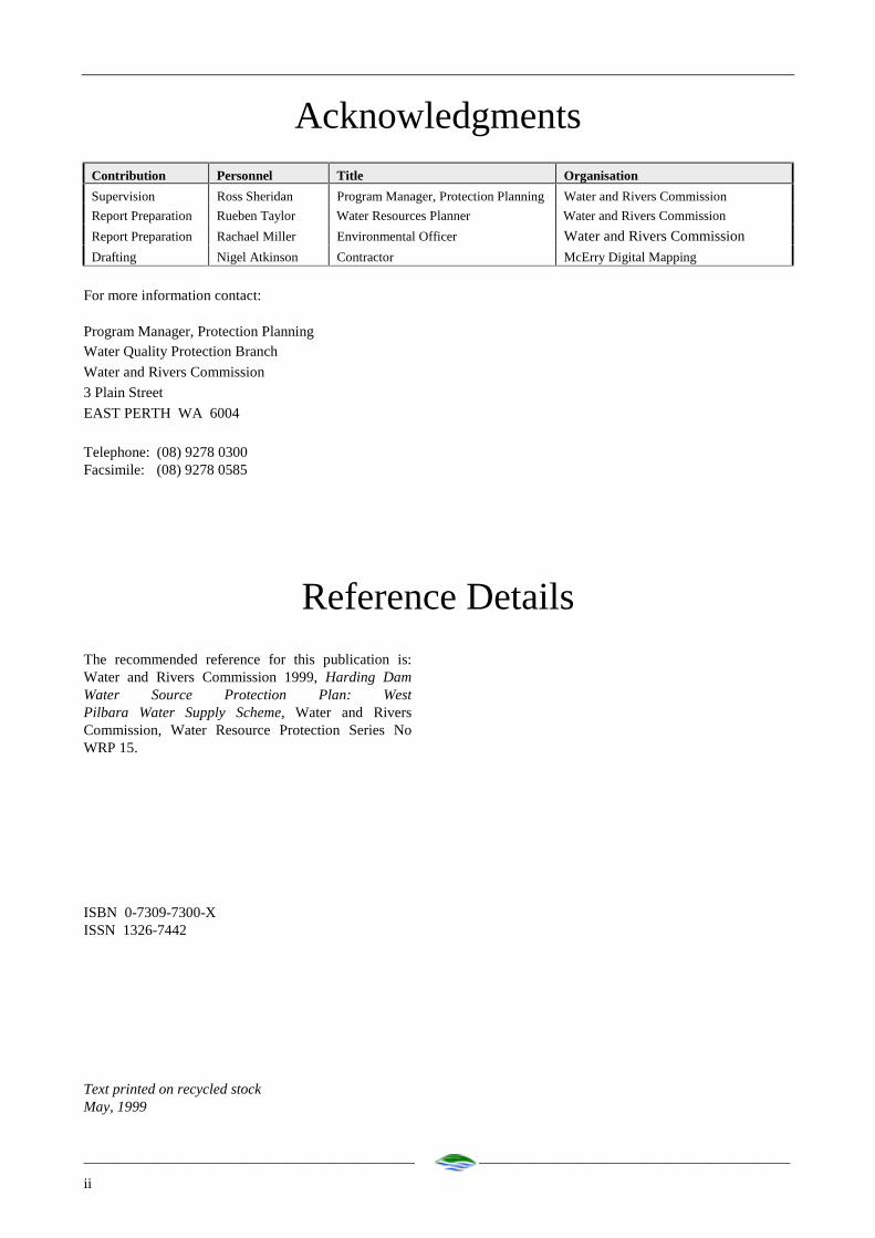
AcknowledgmentsContribution Personnel Title Organisation
Supervision Ross Sheridan Program Manager, Protection Planning Water and Rivers Commission
Report Preparation Rueben Taylor Water Resources Planner Water and Rivers Commission
Report Preparation Rachael Miller Environmental Officer Water and Rivers Commission
Drafting Nigel Atkinson Contractor McErry Digital Mapping
For more information contact:
Program Manager, Protection PlanningWater Quality Protection Branch
Water and Rivers Commission
3 Plain Street
EAST PERTH WA 6004
Telephone: (08) 9278 0300Facsimile: (08) 9278 0585
Reference Details
The recommended reference for this publication is:Water and Rivers Commission 1999, Harding DamWater Source Protection Plan: WestPilbara Water Supply Scheme, Water and RiversCommission, Water Resource Protection Series NoWRP 15.
ISBN 0-7309-7300-XISSN 1326-7442
Text printed on recycled stockMay, 1999

_____________________________________________ _____________________________________________
iii
ForewordWater Source Protection Plans
Water Source Protection Plans establish the level of
protection required within Water Reserves. The plans
identify sources of contamination that should be
investigated and set out programs for management of
the resource. Water Source Protection Plans are
developed in consultation with affected landowners
and industry groups and relevant government agencies.
Proclaiming Water Reserves under the Country Areas
Water Supply Act (1947) protects the quality of water
sources in country Western Australia. The Act’s by-
laws enable the Water and Rivers Commission to
control potentially polluting activities, to regulate land
use, inspect premises and to take steps to prevent or
clean up pollution.
The Water and Rivers Commission aims to work pro-
actively with planning agencies to incorporate water
protection in the land planning process. Decisions on
land use zoning and subdivision applications have a
significant impact on the protection of water sources.
The Commission supports the amendment of Town
Planning Schemes and Development Strategies that
reflect land use compatible with Water Source
Protection Plans.
This Water Source Protection Plan provides a basis for
establishing compatible land uses within the Harding
Dam Catchment Area and is a mechanism for practical
implementation of the Commission’s protection
strategies. Local government decision-makers, State
planning authorities and operational staff are
encouraged to recognise this document as a basis for
ensuring the long term protection of this groundwater
resource for generations to come.
Water quality protection framework
The Water and Rivers Commission is responsible for
managing and protecting Western Australia’s water
resources. The Commission has developed policies for
the protection of public drinking water source areas
(PDWSAs) that include three levels of priority
classification.
Priority 1 (P1) source protection areas are defined to
ensure that there is no degradation of the water
source. P1 areas are declared over land where the
provision of the highest quality public drinking water is
the prime beneficial land use. P1 areas would typically
include land under Crown ownership. P1 areas are
managed in accordance with the principle of riskavoidance and so land development is generally not
permitted.
Priority 2 (P2) source protection areas are defined to
ensure that there is no increased risk of pollution to
the water source. P2 areas are declared over land
where low intensity development (such as rural)
already exists. Protection of public water supply
sources is a high priority in these areas. P2 areas are
managed in accordance with the principle of riskminimisation and so some development is allowed
under specific guidelines.
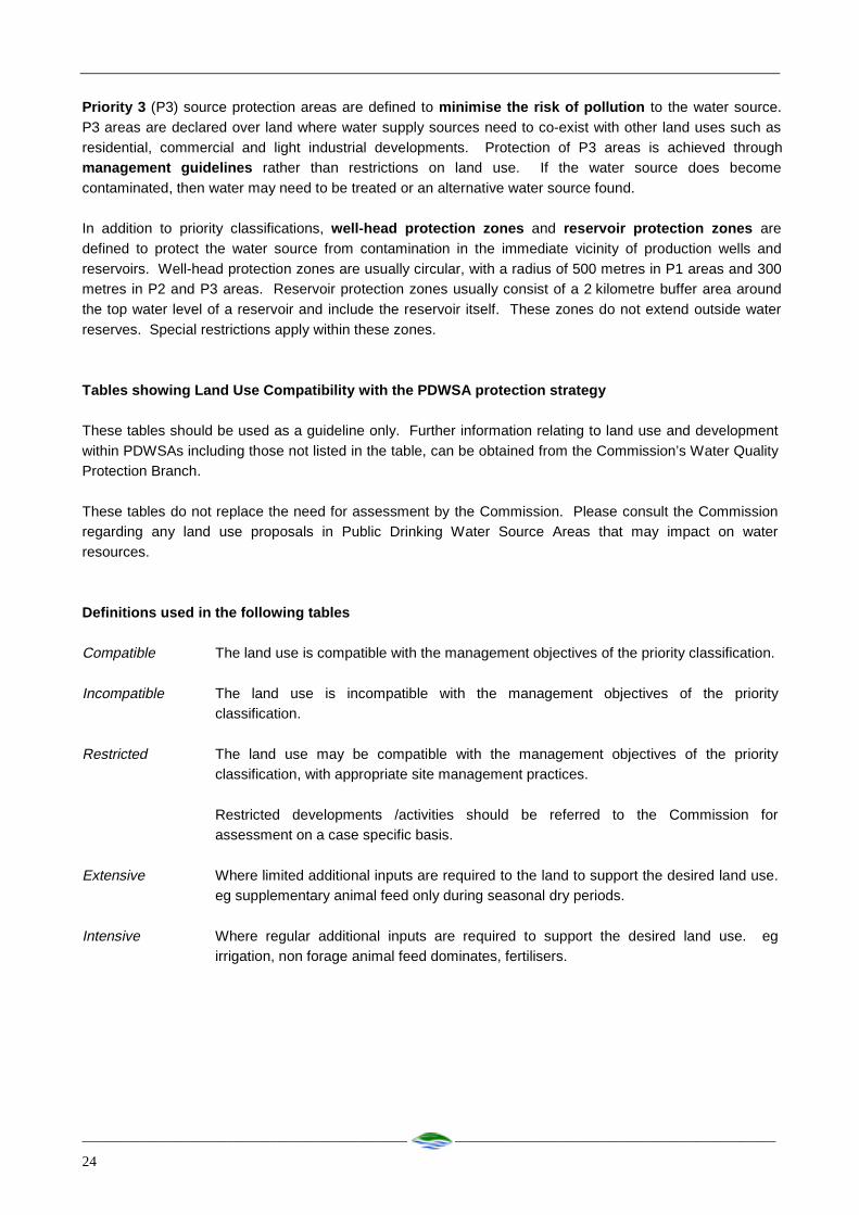
Priority 3 (P3) source protection areas are defined to
minimise the risk of pollution to the water source. P3
areas are declared over land where water supply
sources need to co-exist with other land uses such as
residential, commercial and light industrial
developments. Protection of P3 areas is achieved
through management guidelines rather than
restrictions on land use. If the water source does
become contaminated, then water may need to be
treated or an alternative water source found.
In addition to priority classifications, well-headprotection zones and reservoir protection zones are
defined to protect the water source from contamination
in the immediate vicinity of production wells and
reservoirs. Well-head protection zones are usually
circular, with a radius of 500 metres in P1 areas and
300 metres in P2 and P3 areas. Reservoir protection
zones usually consist of a 2 kilometre buffer area
around the top water level of a reservoir and include
the reservoir itself. These zones do not extend outside
water reserves. Special restrictions apply within these
zones.

_____________________________________________ _____________________________________________
iv
Contents
Summary 1
1. Introduction 2
2. Hydrology 2
3. Existing and proposed land use 2
4. Potential for contamination 6
5. Proposed proclaimed area 12
Recommendations 14
Implementation Strategy 15
References 18
Glossary 19
Appendices
Appendix 1: Incidence of recreational activities in the
Harding Dam Catchment 21
Appendix 2: Land use compatibility in Public Drinking Water Source Areas 22
Appendix 3: Above ground chemical storage tanks in
Public Drinking Water Source Areas 31
Appendix 4: Plates of potential contaminating threats
Figures
Figure 1. Harding Dam locality map ...........................4
Figure 2. Harding Dam catchment area .......................5
Figure 3. Potential contamination threats ..................11
Figure 4. (Proposed) Harding Dam Catchment Area.13
Tables
Table 1. Potential sources of contamination within the
Harding Dam Water Reserve.....................7

_____________________________________________ _____________________________________________
1
Summary
The Harding Dam Water Reserve is located south of
Roebourne, in the Pilbara region of Western Australia.
The reserve contains the Harding Dam of which feeds
from tributaries of the Harding River, one of the major
drainage systems in the region. The Harding Dam is
approximately 20 km south of Roebourne. The dam
was constructed in 1983-1984 and is used in
conjunction with the Millstream wellfield as part of
the West Pilbara Water Supply Scheme (Water
Corporation, 1997).
The Harding Dam experiences water quality problems
that are usually associated with ‘reservoir overturn’
events and associated inflows. These events cause
elevated turbidity and when the guideline level for
supply is exceeded, the supply is switched to the
Millstream wellfield.
Possible contamination risks to the Harding Dam
catchment are recreational use of the reservoir and
catchment, stray cattle and spillage of diesel carried
on two railways that traverse the catchment. The plan
recommends measures that will manage these risks.
The existing Harding Dam Water Reserve boundary
should be modified from a cadastral boundary to
coincide with the hydrological catchment boundary to
capture only land which is contributing to the Harding
Dam. In addition, the proposed catchment area should
be classified for Priority 1 source protection.
This plan has undergone extensive consultation during
the development process. Discussions were held with
key stakeholders prior to the preparation of the draft
plan. The draft plan was released for comment to key
stakeholders including affected landowners, Water
Corporation, Ministry for Planning, Department of
Environmental Protection, Department of Land
Administration, Department of Conservation and Land
Management, Shire of Ashburton, Shire of Roebourne,
Pastoralists and Graziers Association and the
Conservation Council. Comments received were
considered in the preparation of this plan.

_____________________________________________ _____________________________________________
2
1. Introduction
The Harding Dam is approximately 40 km southeast ofKarratha in the Pilbara Region of Western Australia(Figure 1). The dam was constructed in 1983-1984 toaugment the water supply from the Millstreamwellfield (WAWA, 1995).
The Harding Dam Water Reserve lies within the Shiresof Roebourne and Ashburton.
The Water Corporation operates the West PilbaraWater Supply Scheme which utilises water supplyfrom the Harding Dam in conjunction with theMillstream wellfield to supply industrial and domesticwater supply to the towns of Dampier, Karratha,Wickham, Roebourne, Point Samson and CapeLambert.
The current conjunctive licensed allocation forabstraction from the Harding Dam with the Millstreamaquifer is 15 GL/annum.
Water from the Harding Dam is used in the WestPilbara Water Supply Scheme except when waterquality problems persist or the water level in the dam isbelow a certain level. At these times, water is takenfrom the Millstream aquifer. The use of Harding Damas a water source is generally restricted toapproximately eight months of the year. It is proposedto construct a water treatment plant to improve thewater quality of the dam which will ultimately increaseits use.
The Harding Dam catchment experiences extremelyvariable rainfall due to the incidence of tropicalcyclones and depressions. The average annual rainfallfor the region is 330 mm with a low of 3.4 mm and ahigh of 1060 mm recorded at Roebourne, where inexcess of 100 years data has been collected. Typicallythe rainfall occurs between January and June.
2. Hydrology
The Harding Dam catchment covers part of thenorthwest area of the Hamersley Basin. In this region,the Lower Proterozoic Fortescue Group (consistingmainly of volcanic rocks) have been intruded by CooyaPooya Dolerite. The walls of the gorges and nearbyhills are covered by scree consisting of large doleriteboulders, with very little soil material occurring withinthe scree. Runoff is high due to the intense rainfallevents and relatively impervious nature of thecatchment.
Soil types consist of solonised and alluvial soils thathave been disturbed and are susceptible to erosion.These soils represent a large source of sediment to thedam.
The Harding Dam Catchment (Figure 2) has an area ofapproximately 1100 km2 and the mean annual flow inthe Harding River is 38 GL/year (Dames and Moore,1982). Flow is irregular and varying in quantity withno certainty that the river will flow in any particularmonth or year. Runoff is generally greater for themonths January to June due to tropical cyclone andthunderstorm activity.
The full supply level of the dam is 60 m AHD resultingin a storage capacity of 63 800 m3 and surface area of14 km2.
The Harding Dam occasionally has problems withwater quality deterioration, particularly with turbidity,iron, manganese, phytoplankton, taste and odour(WAWA, 1992). Water quality problems areassociated with large inflows and as a consequence ofseasonal destratification and reservoir turnover.
An aerator was installed in the dam in 1986 in anattempt to overcome water quality problems. Thisappears to have been successful in overcoming tasteand odour problems but turbidity continues to be aproblem (WAWA, 1992).
For approximately 8 months of the year, turbiditylevels are below 5 NTU (Nephelometric TurbidityUnits). For the remaining period, turbidity increases tobetween 7 and 20 NTU which above NH&MRC(1996) aesthetic drinking water guidelines. The WaterCorporation is currently investigating the use ofmicrofiltration and deep bed filtration techniques fortreating turbidity at Harding Dam.
Salinity levels in the dam range from 100 to 500 mg/Lwith an average of 200 mg/L. This is well withinNH&MRC guidelines.
3. Existing and proposed land use
Most of the existing Harding Dam Water Reserve iscovered by Land Act Reserve 35798 which is jointlyvested with the Water and Rivers Commission andWater Corporation for water supply purposes.
Part of the upper catchment of the Harding Dam is inthe Millstream-Chichester National Park that ismanaged by CALM. A review of the Millstream-Chichester National Park Management Plan is beingundertaken.
Parts of the catchment are also under pastoral leaseincluding Mount Welcome (3114/265) and Pyramid(3114/268) leases. Cattle and sheep are grazed onthese leases.
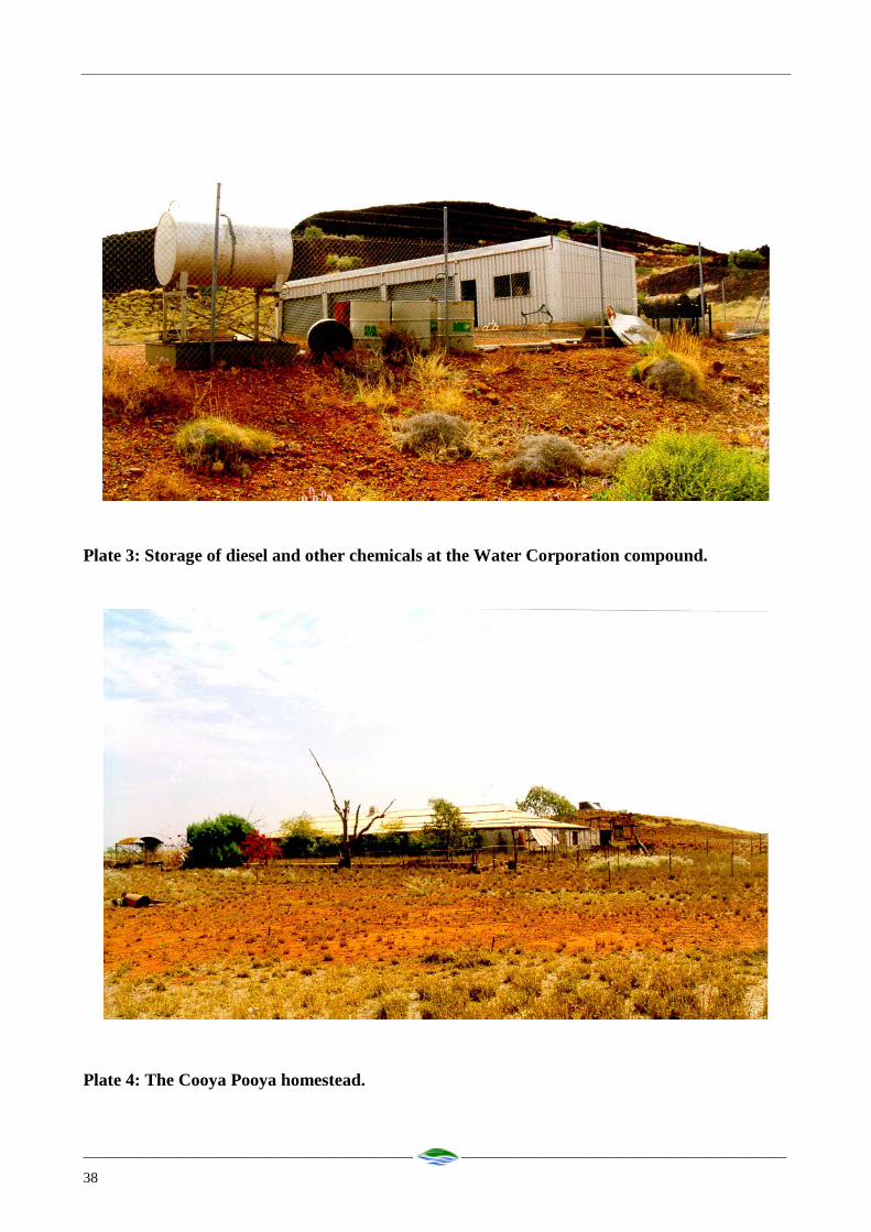
The Cooya Pooya homestead (Plate 4) is located closeto the full supply level of the dam and has beenregistered by the Heritage Council. There is potential

_____________________________________________ _____________________________________________
3
for this site to be developed for heritage andconservation purposes.
There is access to the Water Reserve for recreationwith visitors entering via non-gazetted tracks.Aboriginal cultural sites such as the Cooya Pooyahomestead, Table Top Hill and other cultural sites arealso visited by Aboriginal people.
Two railways traverse the catchment. ThePannawonica to Cape Lambert railway (operated byRobe River Mining Co. Pty Ltd) runs parallel to theHarding River (Plate 1). The Dampier to Paraburdoorailway (operated by Hamersley Iron Pty Ltd) crossesthe upper reaches of the catchment.
There are serval tracks though the catchment whichserve for recreational purposes. The Cooya PooyaRoad services the Pannawonica to Cape Lambertrailway and is used for access into the catchment.

_____________________________________________ _____________________________________________
4
Figure 1. Harding Dam locality map
INDIAN OCEAN
Robe
River
Fortescue
River
Rive
r
Rive
r
Sherlock
River
Cane River
HARDING DAMHa
rdin
g
Georg
e
Maitland
River

_____________________________________________ _____________________________________________
5
Figure 2. Harding Dam catchment area
Fortescue
River
Maitland
Rive
r
Geo
rge
MILLSTREAM
Hard
ing
River
Rive
r

_____________________________________________ _____________________________________________
6
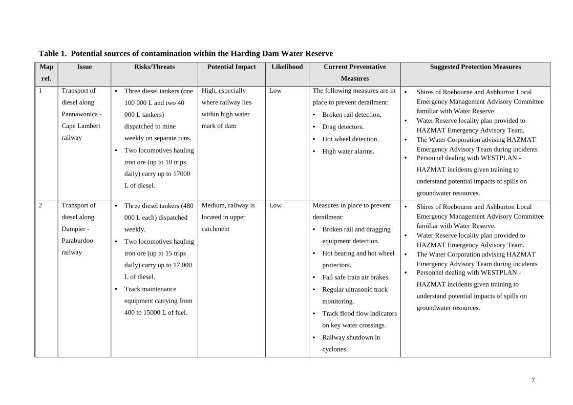
4. Potential for contamination
Table 1. Identified potential contaminant threats in the
proposed Water Reserve. Potential Impact indicates
the level of risk the issue is to the water source and
Likelihood indicates the chance of the issue
contaminating the water source. Figure 3 shows a map
of potential contaminant threats.
7
Table 1. Potential sources of contamination within the Harding Dam Water Reserve
Map
ref.
Issue Risks/Threats Potential Impact Likelihood Current Preventative
Measures
Suggested Protection Measures
1 Transport of
diesel along
Pannawonica -
Cape Lambert
railway
• Three diesel tankers (one
100 000 L and two 40
000 L tankers)
dispatched to mine
weekly on separate runs.
• Two locomotives hauling
iron ore (up to 10 trips
daily) carry up to 17000
L of diesel.
High, especially
where railway lies
within high water
mark of dam
Low The following measures are in
place to prevent derailment:
• Broken rail detection.
• Drag detectors.
• Hot wheel detection.
• High water alarms.
• Shires of Roebourne and Ashburton Local
Emergency Management Advisory Committee
familiar with Water Reserve.
• Water Reserve locality plan provided to
HAZMAT Emergency Advisory Team.
• The Water Corporation advising HAZMAT
Emergency Advisory Team during incidents• Personnel dealing with WESTPLAN -
HAZMAT incidents given training to
understand potential impacts of spills on
groundwater resources.
2 Transport of
diesel along
Dampier -
Paraburdoo
railway
• Three diesel tankers (480
000 L each) dispatched
weekly.
• Two locomotives hauling
iron ore (up to 15 trips
daily) carry up to 17 000
L of diesel.
• Track maintenance
equipment carrying from
400 to 15000 L of fuel.
Medium, railway is
located in upper
catchment
Low Measures in place to prevent
derailment:
• Broken rail and dragging
equipment detection.
• Hot bearing and hot wheel
protectors.
• Fail safe train air brakes.
• Regular ultrasonic track
monitoring.
• Track flood flow indicators
on key water crossings.
• Railway shutdown in
cyclones.
• Shires of Roebourne and Ashburton Local
Emergency Management Advisory Committee
familiar with Water Reserve.
• Water Reserve locality plan provided to
HAZMAT Emergency Advisory Team.
• The Water Corporation advising HAZMAT
Emergency Advisory Team during incidents• Personnel dealing with WESTPLAN -
HAZMAT incidents given training to
understand potential impacts of spills on
groundwater resources.

8
(Continued)Map
ref.
Issue Risks/Threats Potential
Impact
Likelihood Current Preventative Measures Suggested Protection
Measures
3 Development of
abandoned Cooya Pooya
homestead
• Development may be incompatible with
water resource protection
• May increase access to catchment.
Unknown, until
proposal put
forward.
Moderate,
Cooya Pooya
lies within high
water mark of
dam
Not applicable Commission and the
Water Corporation
continue to jointly
manage Cooya Pooya
homestead
4 Rubbish tip at abandoned
Cooya Pooya homestead
Agricultural waste, cans, bottles in tip. Low, tip is not
in use.
Moderate,
Cooya Pooya
lies within high
water mark of
dam
• Water Corporation and the
Commission have conducted a
limited clean-up of the site.
• Water Corporation tests water
in dam close to tip site and no
contaminate leaching has been
detected.
Water Corporation to
continue to sample
water quality near tip
site during routine
sampling.
5 Chemical storage at
Water Corporation
compound
Storage of fuels, solvents and oils (Plate 3). Low Low, quantities
stored are minor.
• Secure compound.
• Concrete base.
• Water Corporation currently
assessing need for compound.
Chemical storage area
be bunded to
Commission’s
requirements
(Appendix 3).
n/a Proposed Karratha - Tom
Price road
• Acute contamination from traffic
accidents causing spills.
• Cumulative impacts from stormwater
runoff.
• Increased access to the catchment area
and reservoir.
Moderate – if
located within
catchment area.
.
Low Road route is planned to be outside
catchment area.
Liaison with the
Commission during
planning stages.
9
(Continued)Map
ref.
Issue Risks/Threats Potential
Impact
Likelihood Current Preventative Measures Suggested Protection
Measures
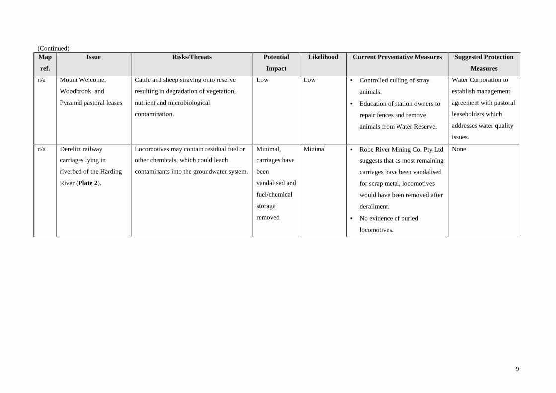
n/a Mount Welcome,
Woodbrook and
Pyramid pastoral leases
Cattle and sheep straying onto reserve
resulting in degradation of vegetation,
nutrient and microbiological
contamination.
Low Low • Controlled culling of stray
animals.
• Education of station owners to
repair fences and remove
animals from Water Reserve.
Water Corporation to
establish management
agreement with pastoral
leaseholders which
addresses water quality
issues.
n/a Derelict railway
carriages lying in
riverbed of the Harding
River (Plate 2).
Locomotives may contain residual fuel or
other chemicals, which could leach
contaminants into the groundwater system.
Minimal,
carriages have
been
vandalised and
fuel/chemical
storage
removed
Minimal • Robe River Mining Co. Pty Ltd
suggests that as most remaining
carriages have been vandalised
for scrap metal, locomotives
would have been removed after
derailment.
• No evidence of buried
locomotives.
None

10
(Continued)Map
ref.
Issue Risks/Threats Potential
Impact
Likelihood Current Preventative Measures Suggested Protection
Measures
n/a Recreation on the
reservoir and within
Water Reserve
See Appendix 1 for list of current
incidence of recreational activities.
• Access to Water Reserve via non-
gazetted tracks to Aboriginal cultural
sites, Cooya Pooya homestead and
Table Top Hill.
See
Appendix 1
See
Appendix 1
Country Areas Water Supply Act by-laws
enable prosecution for illegal recreation within
Water Reserves.
By-laws 31, 34, 35 and 36 of this Act have been
amended to state:
• Bathing is allowed more than 300 m
upstream of the high water mark of the dam.
• Cutting of timber for campfires is allowed.
• Hunting, shooting and fishing not permitted
within the high water mark of the dam.
Signage by Water Corporation explains
catchment constraints.
• A recreation
management plan
should be
developed in
consultation with
CALM if there is
increased
pressure/illegal
access to the
catchment that may
impact on water
resources.
• Access to the
catchment should
be controlled
through the
management of
access tracks.

_____________________________________________ _____________________________________________
11
Figure 3. Potential contamination threats
3114
2693114
265
3114265
265
3114
265
Fortescue
River
3114
265
3114
269
3114
3114
3114
265
265
Maitland
Rive
r
Geo
rge
MILLSTREAM
265
268
3114
Hard
ing
River
Rive
r

_____________________________________________ _____________________________________________
12
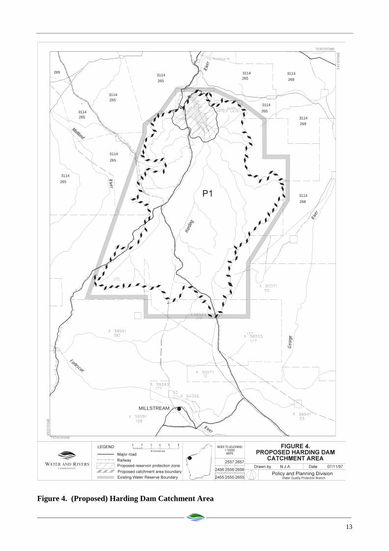
5. Proposed proclaimed area
The existing Harding Dam Water Reserve is shown in
Figure 4 along with the catchment area boundary. The
catchment area boundary follows the topographic
divide of the Harding River catchment and is the
proposed boundary of the Harding Dam Catchment
Area. The modification can be justified as it includes
only the watershed of the Harding River.
The proposed Harding Dam Catchment Area should be
classified for Priority 1 source protection. This
classification is justified for the following reasons:
• The Harding Dam is of strategic importance to
towns that are part of the West Pilbara Water
Supply Scheme.
• All water within this boundary has the potential to
contribute to flow in the Harding River, and end up
in the reservoir.
• Most of the catchment lies within Land Act
Reserve 35798, which is vested for water supply
purposes.
• The remaining land is in the Millstream Chichester
National Park or is under pastoral lease. Both of
these land uses are compatible with the water
resource protection objectives for Priority 1 areas.
• Any intensification of land use or increased access
to the catchment has the potential to contribute to
water quality problems.
In addition, a reservoir protection zone consisting of a
2 kilometre area around the top water level of the
reservoir (and including the reservoir) should be
established. Specific restrictions will apply in this
area.
_____________________________________________ _____________________________________________
13
Figure 4. (Proposed) Harding Dam Catchment Area
3114
2693114
265
3114265
265
3114
265
Fortescue
River
3114
265
3114
269
3114
3114
3114
265
265
Maitland
Rive
r
Geo
rge
MILLSTREAM
265
268
3114
Hard
ing
River
Rive
r

_____________________________________________ _____________________________________________
14
Recommendations
1. The Harding Dam Catchment Area should be proclaimed under the Country Areas Water Supply Act 1947. 2. Planning strategies should incorporate the management principles outlined in the Water and Rivers Commission’s
Water Quality Protection Notes- Land Use Compatibility in Public Drinking Water Source Areas (Appendix 2)and reflect the Priority 1 classification given to the catchment area.
3. All development proposals within the catchment area which are likely to impact on water quality should be
referred to the Water and Rivers Commission. 4. The location of the recently installed signage around the catchment should be reviewed because of the new
boundary changes and the new road route proposed for the area. 5. Incidents covered by WESTPLAN – HAZMAT in the Harding Dam Catchment Area should be addressed through
the following measures:
• The Shires of Roebourne and Ashburton Local Emergency Management Advisory Committee (through the
Karratha Emergency Management District) being familiar with the location and purpose of the Harding Dam
Catchment Area.
• The locality plan for the Harding Dam Catchment Area being provided to the Fire and Rescue Services
headquarters for the HAZMAT Emergency Advisory Team.
• The Water Corporation advising the HAZMAT Emergency Advisory Team during incidents in the Harding Dam
Catchment Area.• Personnel dealing with WESTPLAN - HAZMAT incidents in the area given ready access to a locality map of the
Catchment Area and training to understand the potential impacts of spills on the groundwater resource. 5. A surveillance program should be established to identify incompatible land uses or potential contaminant threats
within the catchment area. 6. Catchment surveillance and by-law enforcement activities for the Harding Dam catchment should be delegated to
the Water Corporation and consideration be given to delegation and joint catchment management with CALM forland within the reserve south of AMG 7668N.
7. Chemical storage at the Water Corporation compound should be bunded to the Commission’s requirements(Appendix 3).
8. A management agreement addressing water quality protection issues, including cattle straying over the Water
Reserve should be established with the leaseholders on the Mount Welcome, Woodbrook and Pyramid pastoralleases.
9. Continuation of water quality monitoring close to the Cooya Pooya homestead. 10. Review the modifications made to the Country Areas Water Supply Act by-laws 31, 34, 35 and 36. A recreation
management plan should be developed for the Water Reserve which will control potentially contaminatingactivities.
11. Implementation of these recommendations should be reviewed one year after this plan is endorsed. A full reviewof this protection plan should be undertaken approximately every five years.
15
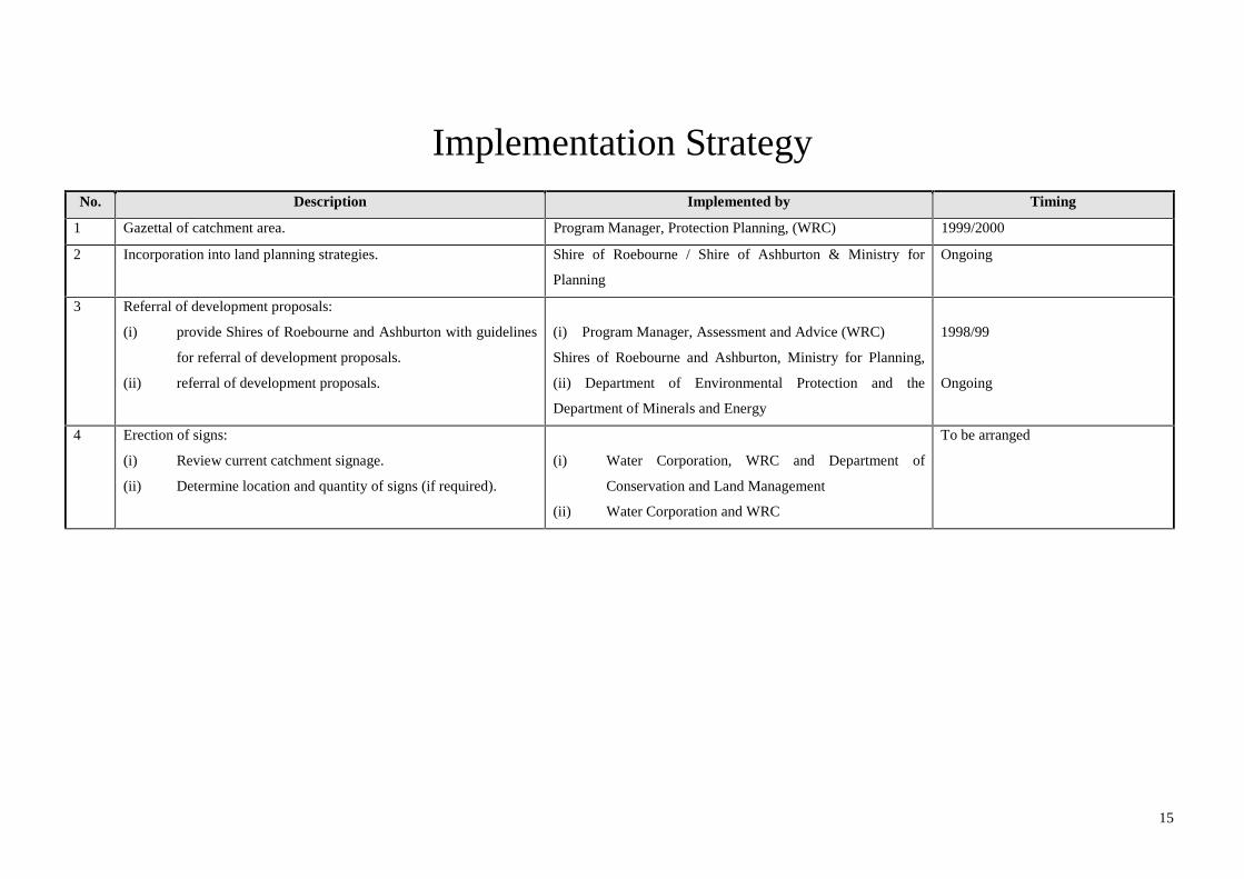
Implementation StrategyNo. Description Implemented by Timing
1 Gazettal of catchment area. Program Manager, Protection Planning, (WRC) 1999/2000
2 Incorporation into land planning strategies. Shire of Roebourne / Shire of Ashburton & Ministry for
Planning
Ongoing
3 Referral of development proposals:
(i) provide Shires of Roebourne and Ashburton with guidelines
for referral of development proposals.
(ii) referral of development proposals.
(i) Program Manager, Assessment and Advice (WRC)
Shires of Roebourne and Ashburton, Ministry for Planning,
(ii) Department of Environmental Protection and the
Department of Minerals and Energy
1998/99
Ongoing
4 Erection of signs:
(i) Review current catchment signage.
(ii) Determine location and quantity of signs (if required).
(i) Water Corporation, WRC and Department of
Conservation and Land Management
(ii) Water Corporation and WRC
To be arranged
16
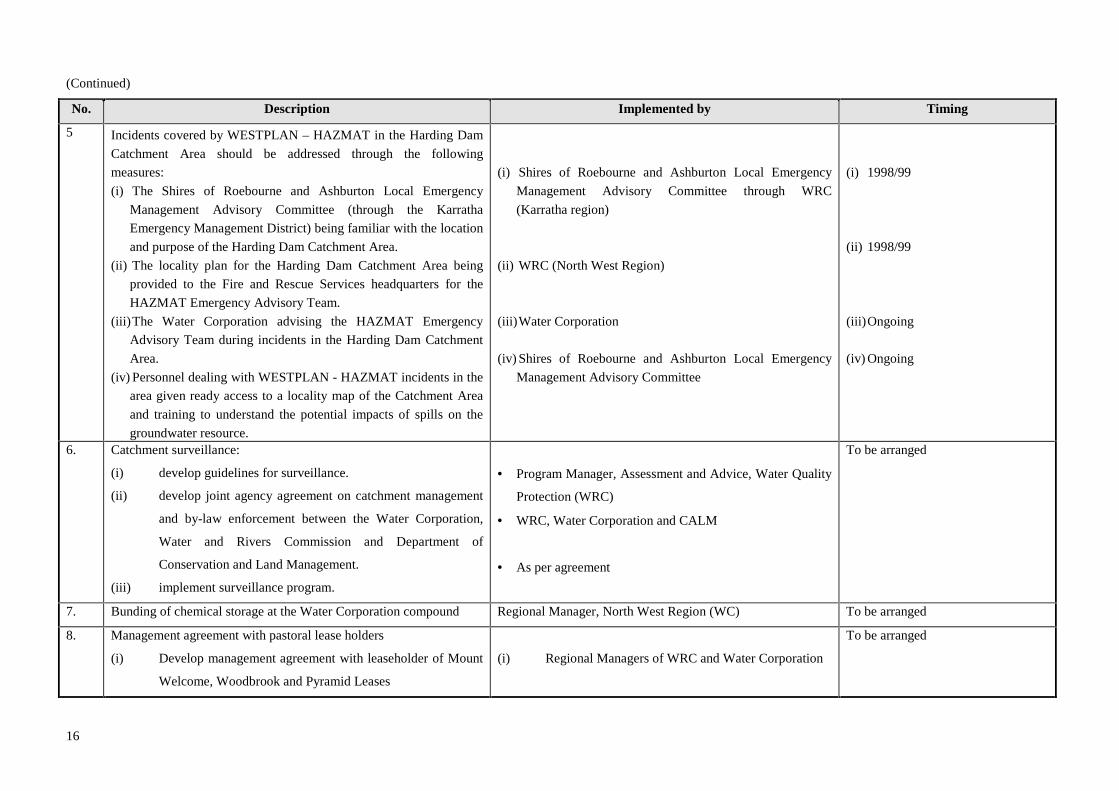
(Continued)
No. Description Implemented by Timing
5 Incidents covered by WESTPLAN – HAZMAT in the Harding Dam
Catchment Area should be addressed through the following
measures:
(i) The Shires of Roebourne and Ashburton Local Emergency
Management Advisory Committee (through the Karratha
Emergency Management District) being familiar with the location
and purpose of the Harding Dam Catchment Area.
(ii) The locality plan for the Harding Dam Catchment Area being
provided to the Fire and Rescue Services headquarters for the
HAZMAT Emergency Advisory Team.
(iii) The Water Corporation advising the HAZMAT Emergency
Advisory Team during incidents in the Harding Dam Catchment
Area.
(iv) Personnel dealing with WESTPLAN - HAZMAT incidents in the
area given ready access to a locality map of the Catchment Area
and training to understand the potential impacts of spills on the
groundwater resource.
(i) Shires of Roebourne and Ashburton Local Emergency
Management Advisory Committee through WRC
(Karratha region)
(ii) WRC (North West Region)
(iii) Water Corporation
(iv) Shires of Roebourne and Ashburton Local Emergency
Management Advisory Committee
(i) 1998/99
(ii) 1998/99
(iii) Ongoing
(iv) Ongoing
6. Catchment surveillance:
(i) develop guidelines for surveillance.
(ii) develop joint agency agreement on catchment management
and by-law enforcement between the Water Corporation,
Water and Rivers Commission and Department of
Conservation and Land Management.
(iii) implement surveillance program.
• Program Manager, Assessment and Advice, Water Quality
Protection (WRC)
• WRC, Water Corporation and CALM
• As per agreement
To be arranged
7. Bunding of chemical storage at the Water Corporation compound Regional Manager, North West Region (WC) To be arranged
8. Management agreement with pastoral lease holders
(i) Develop management agreement with leaseholder of Mount
Welcome, Woodbrook and Pyramid Leases
(i) Regional Managers of WRC and Water Corporation
To be arranged

17
(Continued)No. Description Implemented by Timing
9. Continue water quality sampling close to Cooya Pooya tip site. Regional Manager, North West Region (WC) 1998 - 1999
10. (i) Review CAWS Act (1947) by-law modifications for recreation.
(ii) Develop a recreation management plan for Harding Dam Water
Reserve
(i) Program Manager, Protection Planning (WRC)
(ii) Regional Manager, North West Region (WRC) with
CALM and Water Corporation
To be arranged
11. Review of this plan and recommendations. Program Manager, Protection Planning, Water Quality
Protection (WRC)
Initial review after 1 year.
Full review after 5 years

_____________________________________________ _____________________________________________
18
References
Dames and Moore 1979, Preliminary Environmental
Review - Alternative Water Sources - West Pilbara
Region Western Australia, Prepared for Public Works
Department, February 1979.
Dames and Moore 1982, Harding Dam Project - Draft
Environmental Review and Management Program,
Prepared for Public Works Department, January 1982.
National Health & Medical Research Council 1996,
Australian Drinking Water Guidelines: National Health
and Medical Research Council and Agriculture and
Resource Management Council of Australia and New
Zealand.
Water Authority of Western Australia 1992, Harding
Dam Environmental Management - Triennial Report to
the EPA, July 1988-June 1991 Groundwater and
Environment Branch, Report No. WG 156, September
1992.
Water Authority of Western Australia 1995, Harding
Dam Environmental Management - Triennial Report to
the EPA Water Resources Section, Karratha.
Water Corporation 1997, West Pilbara Water Supply
Scheme Source Review Infrastructure Planning Branch,
February 1997.
_____________________________________________ _____________________________________________
19
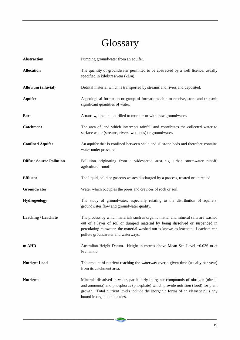
GlossaryAbstraction Pumping groundwater from an aquifer.
Allocation The quantity of groundwater permitted to be abstracted by a well licence, usually
specified in kilolitres/year (kL/a).
Alluvium (alluvial) Detrital material which is transported by streams and rivers and deposited.
Aquifer A geological formation or group of formations able to receive, store and transmit
significant quantities of water.
Bore A narrow, lined hole drilled to monitor or withdraw groundwater.
Catchment The area of land which intercepts rainfall and contributes the collected water to
surface water (streams, rivers, wetlands) or groundwater.
Confined Aquifer An aquifer that is confined between shale and siltstone beds and therefore contains
water under pressure.
Diffuse Source Pollution Pollution originating from a widespread area e.g. urban stormwater runoff,
agricultural runoff.
Effluent The liquid, solid or gaseous wastes discharged by a process, treated or untreated.
Groundwater Water which occupies the pores and crevices of rock or soil.
Hydrogeology The study of groundwater, especially relating to the distribution of aquifers,
groundwater flow and groundwater quality.
Leaching / Leachate The process by which materials such as organic matter and mineral salts are washed
out of a layer of soil or dumped material by being dissolved or suspended in
percolating rainwater, the material washed out is known as leachate. Leachate can
pollute groundwater and waterways.
m AHD Australian Height Datum. Height in metres above Mean Sea Level +0.026 m at
Fremantle.
Nutrient Load The amount of nutrient reaching the waterway over a given time (usually per year)
from its catchment area.
Nutrients Minerals dissolved in water, particularly inorganic compounds of nitrogen (nitrate
and ammonia) and phosphorus (phosphate) which provide nutrition (food) for plant
growth. Total nutrient levels include the inorganic forms of an element plus any
bound in organic molecules.

_____________________________________________ _____________________________________________
20
Pesticides Collective name for a variety of insecticides, fungicides, herbicides, algicides,
fumigants and rodenticides used to kill organisms.
Point Source Pollution Specific localised source of pollution e.g. sewage or effluent discharge, industrialwaste discharge.
Pollution Water pollution occurs when waste products or other substances e.g. effluent, litter,
refuse, sewage or contaminated runoff, change the physical, chemical, biological or
thermal properties of the water, adversely affecting water quality, living species and
beneficial uses.
Public Water Source Area (PWSA) As for UWPCA, but allowing the taking of groundwater for public
supplies.
Recharge Water infiltrating to replenish an aquifer.
Recharge Area An area through which water from a groundwater catchment percolates to replenish(recharge) an aquifer. An unconfined aquifer is recharged by rainfall throughout itsdistribution. Confined aquifers are recharged in specific areas where water leaksfrom overlying aquifers, or where the aquifer rises to meet the surface.
Runoff Water that flows over the surface from a catchment area, including streams.
Saltwater Intrusion The inland intrusion of saltwater into a layer of fresh groundwater.
Scheme Supply Water diverted from a source (or sources) by a water authority or private companyand supplied via a distribution network to customers for urban, industrial orirrigation use.
Storage Reservoir A major reservoir of water created in a river valley by building a dam.
Stormwater Rainwater which has run off the ground surface, roads, paved areas etc and isusually carried away by drains.
Treatment Application of techniques such as settlement, filtration and chlorination to renderwater suitable for specific purposes including drinking and discharge to theenvironment.
Unconfined Aquifer An aquifer containing water, the upper surface of which is lower than the top of theaquifer. The upper surface of the groundwater within the aquifer is called thewatertable.
Underground Water PollutionControl Area UWPCA) An area defined under the Metropolitan Water Supply Sewerage and
Drainage Act, in which restrictions are put on activities that may pollute thegroundwater.
Wastewater Water that has been used for some purpose and would normally be treated anddiscarded. Wastewater usually contains significant quantities of pollutant.
Water Quality The physical, chemical and biological measures of water.
Watertable The upper saturated level of the unconfined groundwater.
Wellfield A group of bores to monitor or withdraw groundwater.

_____________________________________________ _____________________________________________
21
Appendix 1
Incidence of recreational activities in the Harding Dam Catchment
Current Incidence Current Impact
Activity High Medium Low High Medium Low
Horse Riding X X
Trail Bike Riding X X
Firewood Gathering X X
Camping X X
Bush Walking X X
Hunting X X
Car Rallies X X
Angling/Fishing X X
Illegal Crops X X
4WD/Off Road Vehicles X X
Picnicking/BBQ/Fires X X
Rock/Gravel Removal X X
Rubbish Dumping X X
Swimming X X
Boating/Canoeing X X
Photography/Artists X X
Bird Watching X X
Mountain Bikes X X
Educational Research X X
Prospecting X X
Nature Based Tourism,
Tours etc.
X X

_____________________________________________ _____________________________________________
22
Appendix 2
Land use compatibility in Public Drinking Water Source Areas

_____________________________________________ _____________________________________________
23
Water Quality Protection Note
LAND USE COMPATIBILITYIN PUBLIC DRINKING WATER SOURCE AREAS
Purpose
To provide information on land use and activities that may impact on the quality of the State’s waterresources.
These notes provide a basis for developing formal guidelines in consultation with key stakeholders.
Scope
These notes apply to existing and proposed land use within Public Drinking Water Source Areas (PDWSAs).
PDWSAs include Underground Water Pollution Control Areas, Water Reserves and public water supplycatchment areas declared under the Metropolitan Water Supply, Sewerage and Drainage Act 1909, and theCountry Areas Water Supply Act 1947.
Preamble
The following notes reflect the Commission’s current position. They are recommendations only, and may bevaried at the discretion of the Commission.
Overview of Protection Framework
The Water and Rivers Commission is responsible for managing and protecting Western Australia’s waterresources. The Commission has developed policies for the protection of public drinking water source areasthat include three levels of priority classification of lands within PDWSAs.
Priority 1 (P1) source protection areas are defined to ensure that there is no degradation of the watersource. P1 areas are declared over land where the provision of the highest quality public drinking water isthe prime beneficial land use. P1 areas would typically include land under Crown ownership. P1 areas aremanaged in accordance with the principle of risk avoidance and so land development is generally notpermitted.
Priority 2 (P2) source protection areas are defined to ensure that there is no increased risk of pollution tothe water source. P2 areas are declared over land where low intensity development (such as rural) alreadyexists. Protection of public water supply sources is a high priority in these areas. P2 areas are managed inaccordance with the principle of risk minimisation and so some development is allowed under specificguidelines.
_____________________________________________ _____________________________________________
24
Priority 3 (P3) source protection areas are defined to minimise the risk of pollution to the water source.P3 areas are declared over land where water supply sources need to co-exist with other land uses such asresidential, commercial and light industrial developments. Protection of P3 areas is achieved throughmanagement guidelines rather than restrictions on land use. If the water source does becomecontaminated, then water may need to be treated or an alternative water source found.
In addition to priority classifications, well-head protection zones and reservoir protection zones aredefined to protect the water source from contamination in the immediate vicinity of production wells andreservoirs. Well-head protection zones are usually circular, with a radius of 500 metres in P1 areas and 300metres in P2 and P3 areas. Reservoir protection zones usually consist of a 2 kilometre buffer area aroundthe top water level of a reservoir and include the reservoir itself. These zones do not extend outside waterreserves. Special restrictions apply within these zones.
Tables showing Land Use Compatibility with the PDWSA protection strategy
These tables should be used as a guideline only. Further information relating to land use and developmentwithin PDWSAs including those not listed in the table, can be obtained from the Commission’s Water QualityProtection Branch.
These tables do not replace the need for assessment by the Commission. Please consult the Commissionregarding any land use proposals in Public Drinking Water Source Areas that may impact on waterresources.
Definitions used in the following tables
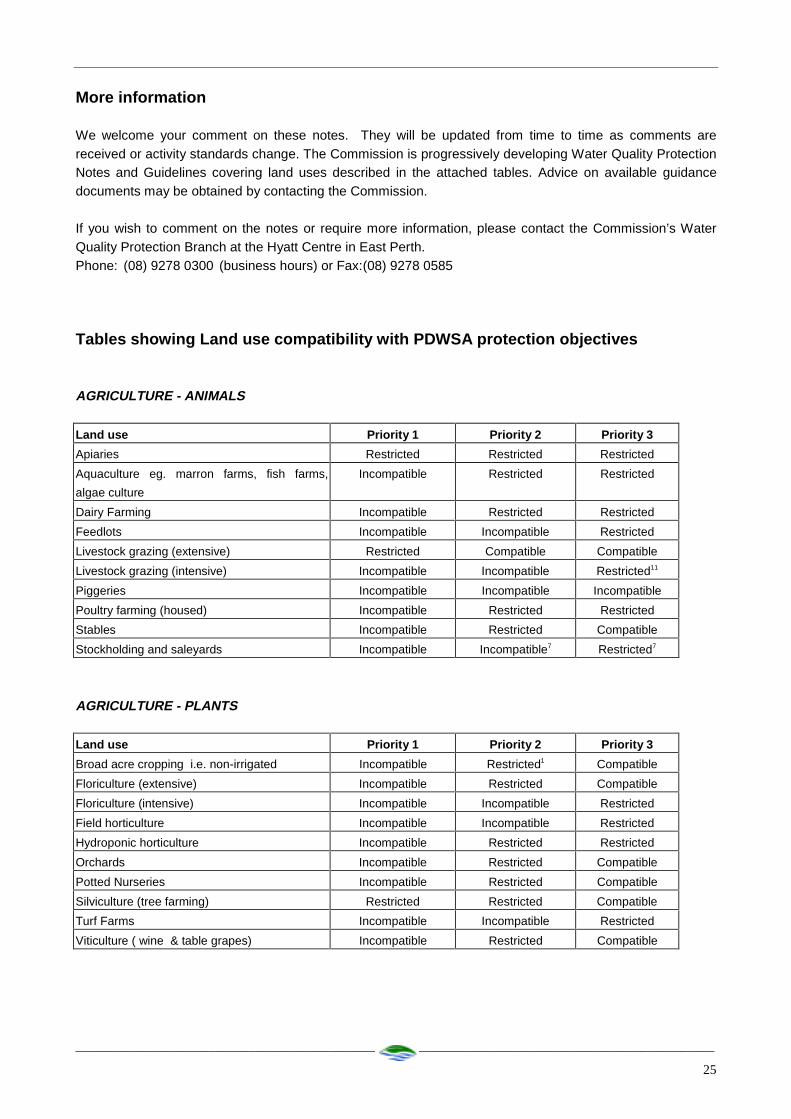
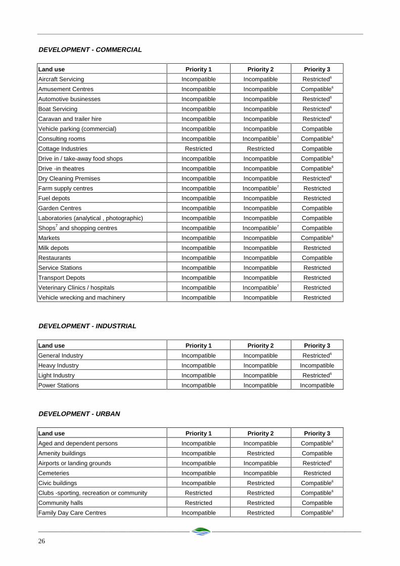
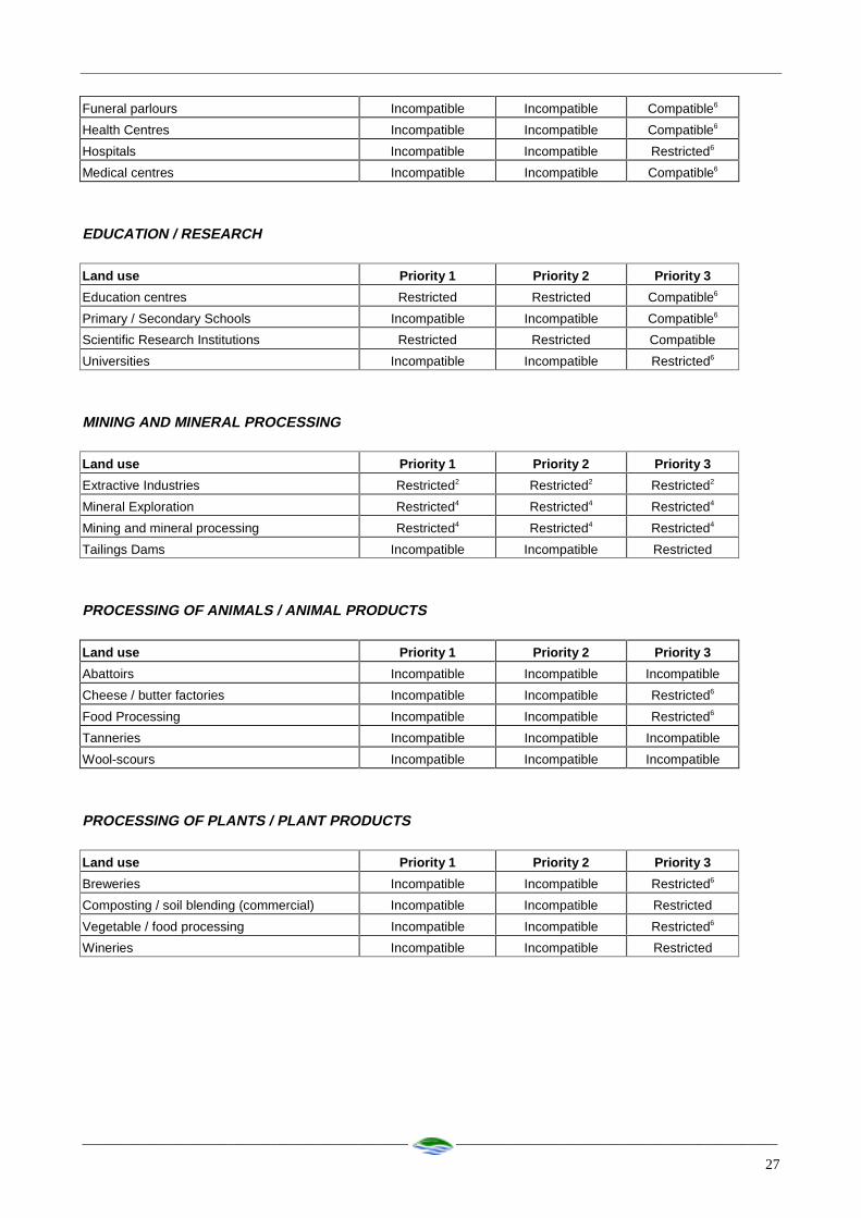
Compatible The land use is compatible with the management objectives of the priority classification.
Incompatible The land use is incompatible with the management objectives of the priorityclassification.
Restricted The land use may be compatible with the management objectives of the priorityclassification, with appropriate site management practices.
Restricted developments /activities should be referred to the Commission forassessment on a case specific basis.
Extensive Where limited additional inputs are required to the land to support the desired land use.eg supplementary animal feed only during seasonal dry periods.
Intensive Where regular additional inputs are required to support the desired land use. egirrigation, non forage animal feed dominates, fertilisers.
_____________________________________________ _____________________________________________
25
More information
We welcome your comment on these notes. They will be updated from time to time as comments arereceived or activity standards change. The Commission is progressively developing Water Quality ProtectionNotes and Guidelines covering land uses described in the attached tables. Advice on available guidancedocuments may be obtained by contacting the Commission.
If you wish to comment on the notes or require more information, please contact the Commission’s WaterQuality Protection Branch at the Hyatt Centre in East Perth.Phone: (08) 9278 0300 (business hours) or Fax:(08) 9278 0585
Tables showing Land use compatibility with PDWSA protection objectives
AGRICULTURE - ANIMALS
Land use Priority 1 Priority 2 Priority 3
Apiaries Restricted Restricted Restricted
Aquaculture eg. marron farms, fish farms,
algae culture
Incompatible Restricted Restricted
Dairy Farming Incompatible Restricted Restricted
Feedlots Incompatible Incompatible Restricted
Livestock grazing (extensive) Restricted Compatible Compatible
Livestock grazing (intensive) Incompatible Incompatible Restricted11
Piggeries Incompatible Incompatible Incompatible
Poultry farming (housed) Incompatible Restricted Restricted
Stables Incompatible Restricted Compatible
Stockholding and saleyards Incompatible Incompatible7 Restricted7
AGRICULTURE - PLANTS
Land use Priority 1 Priority 2 Priority 3
Broad acre cropping i.e. non-irrigated Incompatible Restricted1 Compatible
Floriculture (extensive) Incompatible Restricted Compatible
Floriculture (intensive) Incompatible Incompatible Restricted
Field horticulture Incompatible Incompatible Restricted
Hydroponic horticulture Incompatible Restricted Restricted
Orchards Incompatible Restricted Compatible
Potted Nurseries Incompatible Restricted Compatible
Silviculture (tree farming) Restricted Restricted Compatible
Turf Farms Incompatible Incompatible Restricted
Viticulture ( wine & table grapes) Incompatible Restricted Compatible
_____________________________________________ _____________________________________________
26
DEVELOPMENT - COMMERCIAL
Land use Priority 1 Priority 2 Priority 3
Aircraft Servicing Incompatible Incompatible Restricted6
Amusement Centres Incompatible Incompatible Compatible6
Automotive businesses Incompatible Incompatible Restricted6
Boat Servicing Incompatible Incompatible Restricted6
Caravan and trailer hire Incompatible Incompatible Restricted6
Vehicle parking (commercial) Incompatible Incompatible Compatible
Consulting rooms Incompatible Incompatible7 Compatible6
Cottage Industries Restricted Restricted Compatible
Drive in / take-away food shops Incompatible Incompatible Compatible6
Drive -in theatres Incompatible Incompatible Compatible6
Dry Cleaning Premises Incompatible Incompatible Restricted6
Farm supply centres Incompatible Incompatible7 Restricted
Fuel depots Incompatible Incompatible Restricted
Garden Centres Incompatible Incompatible Compatible
Laboratories (analytical , photographic) Incompatible Incompatible Compatible
Shops7 and shopping centres Incompatible Incompatible7 Compatible
Markets Incompatible Incompatible Compatible6
Milk depots Incompatible Incompatible Restricted
Restaurants Incompatible Incompatible Compatible
Service Stations Incompatible Incompatible Restricted
Transport Depots Incompatible Incompatible Restricted
Veterinary Clinics / hospitals Incompatible Incompatible7 Restricted
Vehicle wrecking and machinery Incompatible Incompatible Restricted
DEVELOPMENT - INDUSTRIAL
Land use Priority 1 Priority 2 Priority 3
General Industry Incompatible Incompatible Restricted6
Heavy Industry Incompatible Incompatible Incompatible
Light Industry Incompatible Incompatible Restricted6
Power Stations Incompatible Incompatible Incompatible
DEVELOPMENT - URBAN
Land use Priority 1 Priority 2 Priority 3
Aged and dependent persons Incompatible Incompatible Compatible6
Amenity buildings Incompatible Restricted Compatible
Airports or landing grounds Incompatible Incompatible Restricted6
Cemeteries Incompatible Incompatible Restricted
Civic buildings Incompatible Restricted Compatible6
Clubs -sporting, recreation or community Restricted Restricted Compatible6
Community halls Restricted Restricted Compatible
Family Day Care Centres Incompatible Restricted Compatible6
_____________________________________________ _____________________________________________
27
Funeral parlours Incompatible Incompatible Compatible6
Health Centres Incompatible Incompatible Compatible6
Hospitals Incompatible Incompatible Restricted6
Medical centres Incompatible Incompatible Compatible6
EDUCATION / RESEARCH
Land use Priority 1 Priority 2 Priority 3
Education centres Restricted Restricted Compatible6
Primary / Secondary Schools Incompatible Incompatible Compatible6
Scientific Research Institutions Restricted Restricted Compatible
Universities Incompatible Incompatible Restricted6
MINING AND MINERAL PROCESSING
Land use Priority 1 Priority 2 Priority 3
Extractive Industries Restricted2 Restricted2 Restricted2
Mineral Exploration Restricted4 Restricted4 Restricted4
Mining and mineral processing Restricted4 Restricted4 Restricted4
Tailings Dams Incompatible Incompatible Restricted
PROCESSING OF ANIMALS / ANIMAL PRODUCTS
Land use Priority 1 Priority 2 Priority 3
Abattoirs Incompatible Incompatible Incompatible
Cheese / butter factories Incompatible Incompatible Restricted6
Food Processing Incompatible Incompatible Restricted6
Tanneries Incompatible Incompatible Incompatible
Wool-scours Incompatible Incompatible Incompatible
PROCESSING OF PLANTS / PLANT PRODUCTS
Land use Priority 1 Priority 2 Priority 3
Breweries Incompatible Incompatible Restricted6
Composting / soil blending (commercial) Incompatible Incompatible Restricted
Vegetable / food processing Incompatible Incompatible Restricted6
Wineries Incompatible Incompatible Restricted

_____________________________________________ _____________________________________________
28
SUBDIVISION
Land use Priority 1 Priority 2 Priority 3
Dog Kennel Subdivisions Incompatible Restricted Restricted
Rural - minimum lot size = 4 hectares
(un-sewered)
Incompatible Compatible Compatible
Rural - minimum lot size = 1 hectare
(un-sewered)
Incompatible Incompatible Compatible
Special rural - minimum lot size = 2 hectares
(un-sewered)5
Incompatible Restricted8 Restricted8
Special rural - minimum lot size = 1 hectare
(un-sewered)5
Incompatible Incompatible Restricted8,
Urban residential Incompatible Incompatible Compatible6
Note: Subdivision of land to lots of any size is incompatible within Priority 1 areas.
SPORT AND RECREATION
Land use Priority 1 Priority 2 Priority 3
Equestrian centres Incompatible Incompatible Compatible
Golf courses Incompatible Incompatible Restricted
Irrigated recreational parks Incompatible Restricted Restricted
Motor sports i.e permanent racing facilities Incompatible Incompatible Restricted
Public Swimming Pools Incompatible Restricted Restricted
Rifle Ranges Restricted Restricted Compatible
Temporary recreational activities (active) eg
four wheel driving, car rallies
Incompatible Restricted3 Restricted3
Temporary recreational activities (passive) eg.
horse riding, bush walking
Restricted Restricted Restricted
STORAGE OF TOXIC AND HAZARDOUS SUBSTANCES (THS)
Land use Priority 1 Priority 2 Priority 3
Above ground storage of THS Restricted13 Restricted13 Restricted13
Bulk Storage Facilities for THS Incompatible Incompatible Restricted12
Underground storage tanks for THS Incompatible Incompatible Restricted
TOURISM ACCOMMODATION
Land use Priority 1 Priority 2 Priority 3
Bed and Breakfast accommodation Incompatible Restricted Compatible
Caravan Parks Incompatible Incompatible Restricted6
Holiday accommodation eg farm chalets Incompatible Restricted9 Compatible6
Motels, lodging houses, hostels Incompatible Incompatible Compatible6

_____________________________________________ _____________________________________________
29
WASTE TREATMENT AND MANAGEMENT
Land use Priority 1 Priority 2 Priority 3
Deep well injection of liquid wastes Incompatible Incompatible Incompatible
Class I, II and III Landfills Incompatible Incompatible Restricted
Class IV and V Landfills Incompatible Incompatible Incompatible
Recycling depots Incompatible Incompatible Restricted
Refuse transfer stations Incompatible Incompatible Restricted
Sewers (Gravity) Incompatible Incompatible Compatible
Sewers (Pressure Mains) Incompatible Restricted Compatible
Sewage pump station Incompatible Restricted13 Restricted
Used tyre storage / disposal facilities Incompatible Incompatible Incompatible
Wastewater treatment plants Incompatible Incompatible Restricted
Water treatment plants Restricted Restricted Restricted
OTHER DEVELOPMENTS
Land use Priority 1 Priority 2 Priority 3
Caretaker’s housing Restricted Restricted Compatible
Construction projects ( not tabled) Restricted Restricted Restricted
Forestry Restricted1 Compatible Compatible
National Parks Compatible Compatible Compatible
Nature Reserves Compatible Compatible Compatible
Communications receivers / transmitters Restricted Restricted Restricted
Major Transport Routes Incompatible Restricted10 Compatible
Table reference notes:
1. Restrictions apply to fertiliser application rates, with strict controls on the application of pesticides andfield operations.
2. Restrictions apply to the storage of fuels and chemicals, with strict guidelines for rehabilitation. 3. Restrictions on the use of fuel and chemicals apply. 4. Subject to conditions placed on lease. 5. Special rural development requires appropriate planning justification, including provisions in the town
planning scheme text. 6. Must be connected to deep sewerage, where practical, or otherwise to an approved waste disposal
system that meets water quality protection objectives.
7. May be permitted if this use is incidental to the overall land use in the area and consistent with planningstrategies.
8. Restrictions apply to siting of effluent disposal systems in areas with poor land capability and a shallow
depth to groundwater.

_____________________________________________ _____________________________________________
30
9. Restrictions apply on density of accommodation. 10. Restrictions apply on road design and construction and the types of goods that may be carried. 11. Restrictions apply to stocking levels. 12. May be permitted if the type, volume and storage mechanisms for chemicals are compatible with water
quality protection objectives.
13. Activity is incompatible in wellhead protection zones.

_____________________________________________ _____________________________________________
31
Appendix 3
Above ground chemical storage tanks in Public Drinking Water Source Areas

_____________________________________________ _____________________________________________
32
Water Quality Protection Note
ABOVE GROUND CHEMICAL STORAGE TANKS
IN PUBLIC DRINKING WATER SOURCE AREAS
Purpose
To provide information for facilities that may impact on the quality of the State’s water resources.
These notes provide a basis for developing formal best management practice guidelines in consultation withkey stakeholders.
Scope
These notes apply in Public Drinking Water Source Areas where chemicals that are potentially polluting,toxic or hazardous (including fuel) are stored in above ground tanks.Chemicals covered by these notes include:• Substances listed in Section 4 of the Australian Water Quality Guidelines for Fresh and Marine Waters
published by the Australian and New Zealand Environment and Conservation Council (ANZECC),1992.• Substances described in the current Schedules of the Poisons Act 1964.• Concentrates and substances listed in Schedule Classes 3 to 9 of the Explosive and Dangerous Goods
Act, Classification Order of 1988.
Chemicals used for hygiene or similar non-commercial purposes in quantities less than 25 litres areexcluded.
These notes apply to permanent facilities that will be used for 12 months or more. For temporaryinstallations (used for less than 12 months) refer to Water Quality Protection Note – Temporary AboveGround Fuel Storage in Public Drinking Water Source Areas.
Public Drinking Water Source Areas (PDWSAs) describe areas declared under the Metropolitan WaterSupply, Sewerage and Drainage Act 1909 and the Country Areas Water Supply Act 1947 for themanagement and protection of sources of water used for public drinking water supply. They includeUnderground Water Pollution Control Areas (UWPCAs), Water Reserves and Catchment Areas.
Three priority classification areas have been defined in PDWSAs. They are P1, P2 and P3. Priority isdetermined by land tenure, land use and water flow paths. Different management strategies apply in eachpriority area. For further details refer to Water Quality Protection Note – Land Use Compatibility in PublicDrinking Water Source Areas.
Above ground chemical storage tanks also require approval from the Department of Minerals and Energy(DME).
General recommendations
The following notes reflect the Commission’s current position. They are recommendations only and may bevaried at the discretion of the Commission.

_____________________________________________ _____________________________________________
33
Proposals for above ground chemical storage systems in PDWSAs will need to be assessed by the Waterand Rivers Commission prior to DME approval. The proposal should include:• A site plan showing the location of the facility.• Construction details of tank containment compounds.• An inspection and maintenance schedule for the facility to ensure effective containment of chemicals.
If the proposal is located in a UWPCA, permit approval from the Commission is also required.
Chemicals including petroleum products should not be stored within 2 kilometres of the top water level ofpublic water supply reservoirs.
In P1 and P2 public drinking water source areas, elevated tanks are not permitted in wellhead protectionzones.
In P1 and P2 public drinking water source areas, the total storage volume shall not exceed 5000 litres.
Containment Compound Design
Storage tanks and associated containment compounds should comply with the current Australian Standard1940, the Explosive and Dangerous Goods Act 1961 and its regulations.
Storage tanks should be located within containment compounds that effectively capture and containchemical spills. These compounds should capture any leak or jet of liquid from any perforation of the tank orassociated equipment. The Commission’s minimum design criteria are appended to these notes as Plan No.1.
Compounds should be constructed of waterproof reinforced concrete or approved equivalent, which is notadversely affected by contact with chemicals captured within them.
The minimum compound volume should be 110% of the capacity of the largest container system, plus 25%of the total capacity of all other separate containers within the compound.
Underground pipe-work carrying product from the tank external to the bund is unacceptable in P1 and P2areas Underground pipe-work should be secondary contained in P3 areas. In P1 and P2 areas,aboveground pipe-work must be secondary contained. Pipe-work within the bund does not requiresecondary containment.
Compounds should have sufficient capacity to contain spilt chemicals and not be overtopped during extremerainfall events. Additional capacity for rainfall captured within the compound should be calculated using a 1in 100 year return frequency storm event over 24 hours. Design methods should be used as described in thecurrent edition of Australian Rainfall and Runoff produced by the Institution of Engineers, Australia.
Tank equipment such as dispensing hoses, valves, meters, pumps, and gauges should be located within thecompound.
Security should be provided to guard against vandalism when the site is unattended. This should include:• Fencing of the tank compound or adequate security controls at the site.• Locks on unattended dispensing hoses.
The base of the compound should grade towards a liquid retention sump to facilitate recovery of spilt liquids.The sump should be emptied by pumping, not through a valved gravity outlet, which could inadvertently beleft open.
Incompatible or reactive chemicals should be stored in separate bunded compounds.
All chemicals stored within the bunded compounds should be clearly labelled detailing the nature andquantity of chemicals stored within containers. Sight gauges indicating the current volume are recommendedfor tanks larger than 250 litres.
_____________________________________________ _____________________________________________
34
Chemical transfer areas
All chemical transfer activities (in and out of tanks) should occur on an impervious sealed area; kerbed,graded or bunded to prevent liquid runoff to the environment.
Chemical transfer areas should drain away from the perimeter bund to a containment pit. The pit should becapable of holding stormwater from at least a 48 hour, 2 year return frequency storm event, in addition tocontaining potential chemical spills. Designs should provide for the safe and efficient movement of vehicles.
Operation of containment compounds
Chemical spills should be cleaned up immediately. The spilt liquid and clean-up material should beremoved, treated and disposed of outside any PDWSA in accordance with requirements of the Departmentof Environmental Protection’s (DEP) Waste Management Division.
The compound should be maintained to prevent accumulation of stormwater and litter. Only stormwaterassessed as uncontaminated by a suitably qualified and experienced person may be released to soaks oroff-site drainage systems.
In P1 and P2 areas, one of the following measures should be used to prevent accumulation of stormwater:
• A roofed structure that extends at least 1 metre past the edge of the compound. Side walls or verticalroof turn- downs should be used where necessary to prevent intrusion of wind -driven rainfall.
• A reliable assessment and management procedure for disposal of stormwater. The procedure should bedocumented and submitted to the Commission for approval.
In P3 areas, adoption of one of the following measures is recommended:
• Collect and dispose of stormwater outside any PDWSA in accordance with the requirements of the DEP-Waste Management Division.
• Treat stormwater on-site in a separation unit capable of removing contaminating substances. Themethod of treatment will depend on whether effluent is discharged to sewer or disposed of on-site insoaks. Any liquid released to the environment should conform to the criteria for Raw Water for DrinkingWater Supply given in Australian Water Quality Guidelines for Fresh and Marine Waters – ANZECC(1992).
More information
We welcome your comment on these notes. They will be updated from time to time as comments arereceived or industry standards change.
If you wish to comment on the notes or require more information, please contact the Commission’s WaterQuality Protection Branch at the Hyatt Centre in East Perth.Phone: (08) 9278 0300 (business hours) or Fax: (08) 9278 0585

__________________________________________________________________________________________35
A4
PUBLIC DRINKING WATER SOURCE PROTECTION AREAS -
ELEVATED CHEMICAL AND FUEL STORAGE TANKSSPECIFICATION FOR
A

_____________________________________________ _____________________________________________
36
Appendix 4
Plates of potential contaminating threats

_____________________________________________ _____________________________________________
37
Plate 1: The Pannawonica - Cape Lambert railway.
Plate 2: Derelict railway carriages in the Harding riverbed.
_____________________________________________ _____________________________________________
38
Plate 3: Storage of diesel and other chemicals at the Water Corporation compound.
Plate 4: The Cooya Pooya homestead.