water use license application...
TRANSCRIPT
WATER USE LICENSE APPLICATION REPORT
BY
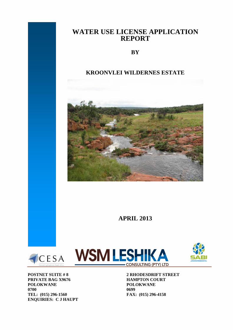
KROONVLEI WILDERNES ESTATE
APRIL 2013
POSTNET SUITE # 8 2 RHODESDRIFT STREET PRIVATE BAG X9676 HAMPTON COURT POLOKWANE POLOKWANE 0700 0699 TEL: (015) 296-1560 FAX: (015) 296-4158 ENQUIRIES: C J HAUPT
WATER USE LICENSE APPLICATION REPORT
WH06092 – Licencing Kroonvlei
COMPILED BY
WSM LESHIKA CONSULTING (PTY) LTD
2 Rhodesdrift Street Postnet Suite #8 Hampton Court Private Bag X9676 POLOKWANE POLOKWANE 0699 0700 TEL : (015) 296-1560 FAX : (015) 296-4158 CONTACT PERSON : C J HAUPT
Page i
WATER USE LICENSE APPLICATION REPORT
TABLE CONTENTS
Page
1. PROJECT DESCRIPTION ............................................................................... 1 2. MERIT OF APPLICATION .............................................................................. 2 2.1 Criteria of Assessment .......................................................................................... 2 2.2 Engineering/Infrastructural Services ..................................................................... 2 2.2.1 Electrical service ................................................................................................... 2 2.2.2 Civil engineering services ..................................................................................... 4 2.3 Geotechnical Considerations ................................................................................. 8 2.4 Floodplains and Wetland Areas ............................................................................ 9 2.4.1 Floodplain demarcation ......................................................................................... 9 2.4.2 Wetland/Sponge areas ........................................................................................... 10 2.5 Agricultural potential ............................................................................................ 11 2.6 Environmental considerations ............................................................................... 12 2.6.1 Relative importance ............................................................................................... 12 2.6.2 Environmental issues investigated ........................................................................ 13 2.6.3 Conclusions : Environmental scoping study ......................................................... 14 2.7 Official plans, policies & strategies ..................................................................... 16 2.7.1 Modimolle integrated development plan ............................................................... 16 2.7.2 Modimolle spatial development framework (SDF) .............................................. 18 2.7.3 National Water Resources strategy ....................................................................... 18 3. WATER USES ..................................................................................................... 19 4. IMPACTS OF THE PROPOSED WATER USES........................................... 22 5. PUBLIC CONSULTATION .............................................................................. 23 6. LIST OF DOCUMENTS .................................................................................... 23
Page ii
REFERENCES FIGURES
FIGURE 1: Site Locality Map FIGURE 2: Settlement Plan of Land development Area 1 FIGURE 3: Settlement Plan of Land development Area 2 FIGURE 4: Stream crossings
TABLES TABLE 1: Section 21 water uses and associated details TABLE 2: Water uses to be authorized APPENDICES APPENDIX A: CORRESPONDENCE WITH DWA APPENDIX B: SURFACE WATER QUALITY APPENDIX C: HYDROGEOLOGICAL REPORT APPENDIX D: ENVIRONMENTAL AUTHORISATION AND ENVIRONMENTAL MANAGEMENT PLAN APPENDIX E: APPROVAL OF THE DEVELOPMENT BY THE DFA TRIBUNAL APPENDIX F: AUTHORITIES APPROVALS APPENDIX G: SECTION 27 MOTIVATION APPENDIX H: PROPOSED RIVER CROSSING DESIGNS APPENDIX I: DWA FORM 758 APPENDIX J: SECTION 21(A) FORMS DW760, DW784, DW789 APPENDIX K: SECTION 21(C) FORMS DW763 APPENDIX L: SECTION 21(I) FORMS DW768 APPENDIX M: SECTION 21(F) FORMS DW766 APPENDIX N: SECTION 21(G) FORMS DW767 APPENDIX O: SUPPLEMENTARY FORMS DW901, DW902, DW905 APPENDIX P: RESOLUTIONS AND ID DOCUMENTS APPENDIX Q: KOONVLEI WILDERNESS ESTATE LAND OWNERS ASSOCIATION NPC REGISTRATION DOCUMENTS APPENDIX R: TITLE DEEDS
WH06092 – Licensing Kroonvlei
Page 1
WATER USE LICENCE APPLICATION REPORT 1. PROJECT DESCRIPTION
The proposed Kroonvlei Private resort is located some 20 kms west of the
town of Modimolle in the Waterberg District of the Limpopo Provice (see figure
1). The development will be located on the following properties, viz:
- Remainder portion of portion 1 of the farm Zuurvlei 403KR, 724.2606ha,
owned by Mrs B Schreuders.
- Portion 7 (a portion of portion 6) of the farm Zuurvlei 403KR, 256.9596ha,
owned by Mrs B Schreuders.
- Portion 2 of the farm Zuurvlei 403KR, 655.4683ha, owned by Mr Bruno
Cigana.
- Remainder portion of portion 6 (portion of portion 1) of the farm Zuurvlei
403KR, 428.2660ha, owned by Mr Rudo Goss.
The total area is 2 064.9545ha.
The project has been divided into 2 land development areas, viz:
- Land Development area 1, consisting of 14 private dwellings, 1 corporate
dwelling unit, a stand for a cultural village, 3 managers houses, staff
accommodation and out buildings for maintenance and equipment required
for the resort, with the remainder of the property to be used for agriculture,
open space, conservation and recreation. See figure 2.
- Land Development area 2, consisting of 47 private dwellings, 3 corporate
dwelling unit, 2 sites for existing graves, with the remainder of the property
to be used for agriculture, open space, conservation and recreation. See
figure 3.
WH06092 – Licensing Kroonvlei
Page 2
2. MERIT OF APPLICATION
2.1. CRITERIA OF ASSESSMENT The application is motivated by means of the assessment of the
development proposal against, and / or in terms of certain fundamental
criteria. The criteria employed include the following:
* Engineering / infrastructural services
* Geotechnical considerations
* Floodplains and wetland areas
* Environmental considerations
* Official plans, policies and strategies
* Chapter 1 DFA-principles
* Agricultural potential
* Tourism infrastructure
Each of these criteria are now used to measure the particular
development proposal against, and a conclusion drawn with regards to
its desirability and /or sustainability.
2.2. ENGINEERING / INFRASTRUCTURAL SERVICES
Two services reports have been compiled by the project electrical and
civil engineers respectively.
2.2.1. Electrical service The document underpinning the discussion on the provision of
electricity to the proposed development project was prepared by
messrs Burotech Consulting Engineers in May 2006, and is titled
:-
‘Services Report. Electrical Reticulation. Proposed
Private Resort & Residential Development Bateleur
Wilderness Estate on Portions 1, 2, 3, 6 and 7 of

WH06092 – Licensing Kroonvlei
Page 3
Farm Zuurvlei – 403 KR and on a portion of the
Remainder of Farm Rhenosterpoort 402 KR.
It is confirmed in the report that ESCOM will be the
service provider to the proposed development.
The existing overhead 22kV transmission lines on the eastern
side of the Property will possibly not be suitable for the
development, due to questionable capacity (has yet to be
verified) and voltage depression problems being experienced
currently. A similar overhead line on the western side of the
development site can possibly be used to serve part of the
development. The report states that :-
‘A new Chikadee type overhead line must be
constructed for approximately 15km from the
Kareefontein substation to cater for new
development in the area. The costs can be
shared by the various developments, such as
on the Tshepe farm’ (p.2)
The project electrical engineers estimate the electrical load for
the project to be around 1 500kVA, using a 5kVA After Diversity
Maximum Demand (ADMD) per household and making
allowance for electricity to the gatehouse, stables, clubhouse,
etc. Due to the nature of the proposed development, the report
states that … ‘The maximum occupancy rate can be as low as
50% which results in a maximum demand of approximately
800kVA for the total development’.
The report states that connection points will be obtained from
both existing overhead lines to the east and west of the
WH06092 – Licensing Kroonvlei
Page 4
development site, by means of 22kV switch-gear, with a
medium-voltage metering panel, from where the developer will
reticulate the cables underground.
The engineers confirm that the on-site electrical reticulation
system will comprise of an underground 11kV or 3,3kV low
voltage system with 11kV / 415V or 3,3kV / 415V mini-
substations from which 415V low-voltage will be fed inside the
development area. Pre-paid metering will be available to each
end-user.
In conclusion, it is evident that the electricity will be available in bulk to the proposed development, to be supplied by, and planned in conjunction with ESKOM. Furthermore a feasible reticulation system been proved.
2.2.2. Civil engineering services
The information here quoted was obtained from the civil services
report for the project prepared by messrs PVA Consulting
Engineers CC during May 2006, titled :
‘Civil Engineering Services Report on Portions
1, 2, 3, 6 & 7 of Farm Zuurvlei 403 KR and a
certain portion of Remainder of Farm
Rhenosterpoort 402 KR, in the Modimolle
Municipal Area, Limpopo Province. “Bateleur
Wilderness Estate”.
* Water : Bulk water will be sourced from boreholes, of
which there are presently two on the development site
which have been tested for the purpose. The project
WH06092 – Licensing Kroonvlei
Page 5
engineers base their information on a specialist
geohydrological report prepared by messrs WSM Leshika
titled :-
‘Hydrogeological Report for the
Proposed Kroonvlei Private Resort.
Modimolle Area’. (March 2012)
The boreholes tested proved a yield of 246 kilolitres per
day (kl/d). The project engineers estimate the peak and
off-peak water demand for the project to be around 110
kl/d and 45 kl/d respectively. (The latter is based on a
25% occupancy rate).
The yield from the two boreholes tested are considered to
be adequate for purposes of the proposed development.
Water storage tanks will furthermore be employed to
ensure 48-hours reserve capacity at any point in time.
The above figures quoted prove the feasibility of water
provision to the new development.
The geohydrological report estimates the sustainable yield
from groundwater sources to be around 232m3/ day,
which exceeds the peak demand (at full occupancy) of the
proposed resort / estate. It furthermore confirms the
quality of the water to be excellent for human
consumption purposes. See Appendix C
With regards to the on-site reticulation of water, the
project engineers propose two ring / circular route
pipelines. The first will serve LDA 1 as well as all
WH06092 – Licensing Kroonvlei
Page 6
communal facilities (e.g. entrance gates, cultural village,
etc.), while the second will serve LDA 2.
In conclusion, it is evident that sufficient water has been proven for the project. Water storage tanks and on-site water reticulation will be strategically positioned / installed, as per engineering design. Water quality has been found to be excellent, i.e. suitable for human consumption.
* Sewerage : The project engineers recommend that a
closed package plant system like the Lillyput system be
employed at each house.
Provision will be made in the design of the system for 900
litres of sewerage effluent to be disposed of per
household daily. Purified water from each treatment plant
will be discharged to the closest stream, with special care
to the prevention of erosion at the points of discharge.
Sewage sludge will be disposed of at the licensed
Modimolle Waste site
The proposed system provides a proven environmentally sensitized sewerage disposal method which will also in this instance ensure the long term sustainability of the project from this point of view. * Roads : As discussed earlier, all internal roads will remain
gravel, and will only be surfaced where steep gradients
are encountered, and then only in an environmentally
acceptable way. All river / stream crossings are marked in
figure 4 and proposed designs are given in Appendix H.
WH06092 – Licensing Kroonvlei
Page 7
In conclusion the upgrading of, and limited extension of existing roads prove feasible for purposes of the proposed development. All stream crossings will be licensed. It is also confirmed that the use and improvement of existing accesses to the development site has been supported by the Roads Authority Limpopo (RAL) see Appendix F.
* Stormwater : Sheet-wash stormwater run-off will be
discharged on the surface, with special care to potential
erosion problems which could arise.
Stormwater is hence not regarded as potentially problematic, and by handling same in accordance with sound environmental practices, this aspect of the resort / estate can also be proven feasible.
* Domestic refuse : All refuse generated in the private
resort / estate will be sorted, collected transported and
disposed of at a registered / licenced municipal landfill
site, by a private contractor. The Modimolle Municipality
has been approached with an official request to permit
their landfill / dumping site to be used for this purpose.
The Municipality has previously granted permission for
similar resorts / estates to dispose of its domestic refuse
at its dumping site. Should this be the case here too, the proposed development will also prove feasible from the viewpoint of refuse removal.
WH06092 – Licensing Kroonvlei
Page 8
2.3. GEOTECHNICAL CONSIDERATIONS
A combined geotechnical and geohydrological desk-top study was
conducted for the development site by messrs PVS Environmental
Services in December 2005, titled :-
‘A Geohydrological & Geotechnical Site Investigation
for the proposed Bateleur Private Resort Development
on Portions 1, 2, 3, 6 & 7 of the Farm Zuurvlei 403 KR
and the Remainder of the Farm Rhenosterpoort 402
KR in the Modimolle Municipal Area, Limpopo
Province’.
The sub-surface geology of the terrain comprises of :-
* sandstone (medium to course grained)
* pebblestone
* tuffaceous greywacke
* siltstone
* shale
* conglomerate
The above being of the Swaershoek Formation of the Nylstroom
Subgroup of the Waterberg Group and Nebo Granite of the Lebowa
Granite Suite of the Bushveld Complex, consisting of :-
* course grained granite (grey to pink)
* volcanic rock
* sandstone
* quartsite
The conclusion drawn in the report is as follows :-

WH06092 – Licensing Kroonvlei
Page 9
‘The area does not reflect any risk for the formation of sinkholes caused by the presence of soluble rocks (dolomite or limestone). There is no evidence of previous mining activity beneath the site’.
Messrs Louis Kruger Geotechnics CC in July 2006 expanded the
information base by their desk-top study titled :
‘Report on the reconnaissance engineering geological
investigation for the proposed private resort situated
on the Remainder of the Farm Rhenosterpoort 402 KR
and Portions 1, 2, 3, 6 & 7 of the Farm Zuurvlei 403
KR’.
The report makes mention of expandable soils near water drainage
channels, collapsible sand over the entire property and the possibility of
perched water tables which may inhibit construction activities during the
rainy season. Suitable construction methods to counter differential
movements caused by expansion / contraction and collapsing soils are
recommended.
2.4. FLOODPLAINS AND WETLAND AREAS 2.4.1. Floodplain demarcation
Messrs African Innovative Solutions and Projects CC concluded
a floodline study for the development site in May 2006, titled :-
‘Zuurvlei 403-KR (Bateleur) 50 & 100-year
Floodline Study’.
WH06092 – Licensing Kroonvlei
Page 10
Based on a hydrological assessment of the development site
seven (7) tributaries to the Sand River as well as the latter itself
were identified and subjected to the so-called Hecras Model
Output, as explained fully in the accompanying report. It was
concluded that :-
* the floodplains, defined by the 1:50 and 1:100-year
floodlines cover a small percentage of the site; and
* no stands in the development would fall within the 1:100
year floodlines.
Both the 1:50 and 1:100-year floodlines as prepared by these
specialists are now reflected on the site layout plan. See figures
2 and 3
2.4.2. Wetland / sponge areas
Dr Buks Henning of Envirodel Ecological and Wildlife
Management Services conducted a wetland demarcation
exercise as part of a wider study titled :-
‘An Environmental Report on the Agricultural
Potential of Soils and Wetland Delineation on
the Farm Zuurvlei 403-KR as part of the
proposed Bateleur Wilderness Estate
Development’ (April 2006)
The demarcation process of wetlands on the site was informed
by the requirements of the Department of Water Affairs and
Forestry (DWAF), more specifically the document known as …’A
WH06092 – Licensing Kroonvlei
Page 11
practical field procedure for identification and delineation of
wetlands and riparian areas’.
According to the report there are two main wetland areas
prevalent on the site. The first is situated on the eastern parts of
the site, closely associated with the Sand River, and the second
on the south-western parts of the site, associated with the
southern-most east / west tributary of the Sand River. Each of
these wetlands were divided in permanent, seasonal and
temporary zones, which were demarcated geographically based
on a set of criteria discussed extensively in the report.
It should be noted that due cognizance was given to the
presence of these wetland areas on the site, in the site layout
planning process. No private lodge stands or communal
buildings / structures will consequently be situated within any of
these wetland areas. Where road-building or improvement of
roads / tracks in the resort / estate have to traverse wetland
areas, the recommendations in this regard in the report will be
strictly adhered to.
In conclusion it can be stated that the wetland areas prevalent in the land development area will be preserved / conserved and treated with great sensitivity a pro pos road-building. No other developments will be situated in the demarcated wetland areas.
2.5. AGRICULTURAL POTENTIAL
The same report by dr Buks Henning quoted in par 4.4 supra, dealt with
the agricultural potential of the area under consideration for a private
resort / estate.

WH06092 – Licensing Kroonvlei
Page 12
Based on guidelines provided for determining of the agricultural
potential of a property by the National Department of Agriculture a
combined desk-top and field survey investigation concluded that, taking
cognizance of all the required criteria in combination, the proposed land
development area has low agricultural potential.
‘The results indicate that the agricultural potential of
soils on the development sites can be considered as
low in general, due to either being shallow and rocky
(central and western portions), or deep and sandy
(eastern areas, excluding wetland zones) in the
development zones’.
‘The only agricultural activity to be considered as being
a viable option under the current climatic conditions is
grazing by game species, especially considering the
veld conditions to be quite diverse’.
2.6. ENVIRONMENTAL CONSIDERATIONS
2.6.1. Relative importance
The importance of the Draft Scoping Report submitted as part of
the DFA-application in term of the requirements of Regulation 31
cannot be over-emphasized. As explained earlier, the
environmental evaluation / assessment of the development site,
as well as other related matters lie at the core of the
environmental sustainability of the proposed new residential
estate. The overall development concept as well as the detailed
lay-out planning of the terrain are the result of an inter-active
process between the project environmentalists and the town-
planning consultants.

WH06092 – Licensing Kroonvlei
Page 13
The fact is that the expert studies by all the other consultants, as
well as several sub-consultants to the environmental process per
se have all contributed to, and informed the resultant
environmental conclusions and ‘recommendations,’ the
importance of which is paramount to the project.
2.6.2. Environmental issues investigated
The issues which were regarded as potentially most significant
from the perspective of the proposed development area are as
follows :
* Fauna and flora
* Geotechnical and geohydrological
* Archeological and cultural / historical
Potentially negative impacts investigated include the following:
* Water usage could come under additional pressure
* The resort / estate could change the character of the area
(sense of place)
* Increased threat of surface and ground water pollution
* Deterioration of gravel roads due to increased traffic loads
* Potential loss of agricultural land
* Potential disturbance / deterioration of the on-site flora
component

WH06092 – Licensing Kroonvlei
Page 14
* Potential disturbance / deterioration of the fauna
component and destruction of it’s natural habitat.
Potentially positive impacts identified include the following :
* the proposed eco-resort is commensurate with the
character of the wider area in which it is situated, and will
add to the prosperity of the region in general
* Implementing the resort / estate will generate funds for
conservation of inter alia the wetlands areas and
maintenance of the game farm (e.g. fire control)
* Employment opportunities will be created during the
construction phase
* Partially destroyed wetland areas will be rehabilitated with
consequent enhancement of bird and faunal life
associated with same
* Economic advantages will result, due to capital
investment, requiring e.g. purchasing of building materials
locally
* The rates and taxes base of Modimolle Municipality will be
expanded
2.6.3. Conclusions : Environmental Scoping Study
The following verbatim excerpt from the Executive Summary of
the environmental report serves to allude to the conclusions
recorded, following the requisite investigation / study :
WH06092 – Licensing Kroonvlei
Page 15
‘Scoping Report. Proposed Development of a
Private Resort Development on Portions 1, 2, 3,
6 and 7 of the Farm Zuurvlei 403 KR and the
Remainder of the farm Rhenosterpoort 402 KR
in the Modimolle Municipal Area, Limpopo
Province’.
• ‘No sensitive environmental components
occur within the study area that could
influence the viability of the proposed
resort development.
• It is expected that no significant
negative impact that could not be
mitigated to acceptable levels should
occur as a result of the project.
• It is trusted that all measurable
measures were undertaken to obtain the
input from interested and affected
Parties during the Public Participating
Programme and that all reasonable
concerns are correctly documented and
satisfactorily addressed in the
Environmental Scoping Report.
• The loss of specific areas for the houses
is insignificant when compared to the
opportunity to develop and maintain the
larger area as a conservation unit.
WH06092 – Licensing Kroonvlei
Page 16
• The Consultant is confident that
additional environmental information not
included in this document will not change
the viability of the project and therefore
trust that no further studies would be
required’.
• An ROD from the Department of
Economic Development, Environment
and Tourism has been obtained and an
Environmental Management plan has
been has been set up. See Appendix D.
2.7. OFFICIAL PLANS, POLICIES & STRATEGIES 2.7.1. Modimolle Ingegrated Development Plan, 2005/6
One of the strategic forward planning documents guiding
development in the Modimolle Municipal Area, is the Modimolle
Integrated Development Plan (IDP). In terms of appropriate
guidelines the IDP accentuates the following aspects :
* subscription to the general principles of development as
per Chapter 1 of the DFA;
* the need for job and income creation, especially for
poverty–stricken communities;
* the need to exploit rural opportunities for tourism and
recreation–related businesses and activities, without
adversely affecting inter alia high-potential agricultural
land;
WH06092 – Licensing Kroonvlei
Page 17
* encouragement to farmers / developers to facilitate land
ownership / tenure to labourers and other previously
disadvantaged individuals / families;
* the tendency of substituting flailing cattle farming
practices for more lucrative game farming, with or without
associated tourism development, is acknowledged;
* the economic advantages to Modimolle town (notably the
business sector) ensuing from resort and recreational
developments in near-by rural areas, are acknowledged
and encouraged;
* the ‘attractive natural surroundings of the Modimolle town
are, and will in future be one of the Municipality’s
strongest attributes. It provides a strong….marketing tool
that could provide impetus to various development
actions’. (IDP, p 185);
* the fact that nature conservation is expensive and public
sector finances restricted will require / necessitate
development in rural areas to generate funding for same.
Due to its close proximity to Modimolle town (± 20 km
westwards), the latter will undoubtedly derive economic ‘spin-
offs’ from the proposed development. Job and income creation,
especially during the construction phase, will furthermore lead to
another aim of the IDP being met. The proposed development
will not be established on high-potential agricultural land, and will
funds generated from the development be partially ploughed
back into :
WH06092 – Licensing Kroonvlei
Page 18
* conservation (e.g. rehabilitation of wetlands, eradication of
alien species); and
* establishing a ‘cultural village’ for staff members, which
will be transferred to a trust (± 62ha), owned by previously
disenfranchised members of the community.
Previous cattle and crop farming operations have caused
excessive damage to the natural environment (e.g. over grazing,
crop fields in wetland and floodplain areas), which will now be
restored and enhanced.
It is therefore evident that the proposed development will conform to the appropriate guidelines extracted from the Modimolle IDP, as discussed above. As such it will make a valuable contribution to the local and regional economy, with associated job and income creating being additional advantages.
2.7.2. Modimolle Spatial Development Framework (SDF)
It is our contention that the proposed development will be
commensurate with the provisions / proposals contained in the
Modimolle SDF.
2.7.3. National Water Resources Strategy
The proposed water uses fall within the National Water
Resources Strategy which promotes the use of local water
resources. Further the Internal Strategic Perspective for the
Mogol catchment acknowledges that groundwater in the area is
still underutilized. See Appendix G, Section 27 motivation.
WH06092 – Licensing Kroonvlei
Page 19
It is therefore evident that the proposed development will conform with the National Water Resources Strategy.
3. WATER USES
The applicant requires authorisation for the following water uses:
(a) Section 21(a) – Taking of water (abstraction of groundwater from 2
boreholes on site);
(b) Section 21(c) – Impeding or diverting the flow in a water course (7 river
crossings have been identified);
(c) Section 21(i) – Altering the beds, banks course or characteristics of a
water course (7 river crossings have been identified where low level
structures will be built);
(d) Section 21(f) – Discharging waste or water containing waste into a water
resource through a pipe, canal, sewer, sea outfall or other conduit. (Each
of the 68 houses will have their own sewage package plant which will
treat the effluent to DWA standards and then release the water in the
closest stream);
(e) Section 21(g) – Disposing of waste which may detrimentally impact on a
water resourse. (Each of the 68 houses will have their own sewage
package plant which will treat the effluent to DWA standards and then
release the water in the closest stream. The sludge will be disposed of at
the licensed Modimolle Waste Site);
WH06092 – Licensing Kroonvlei
Page 20
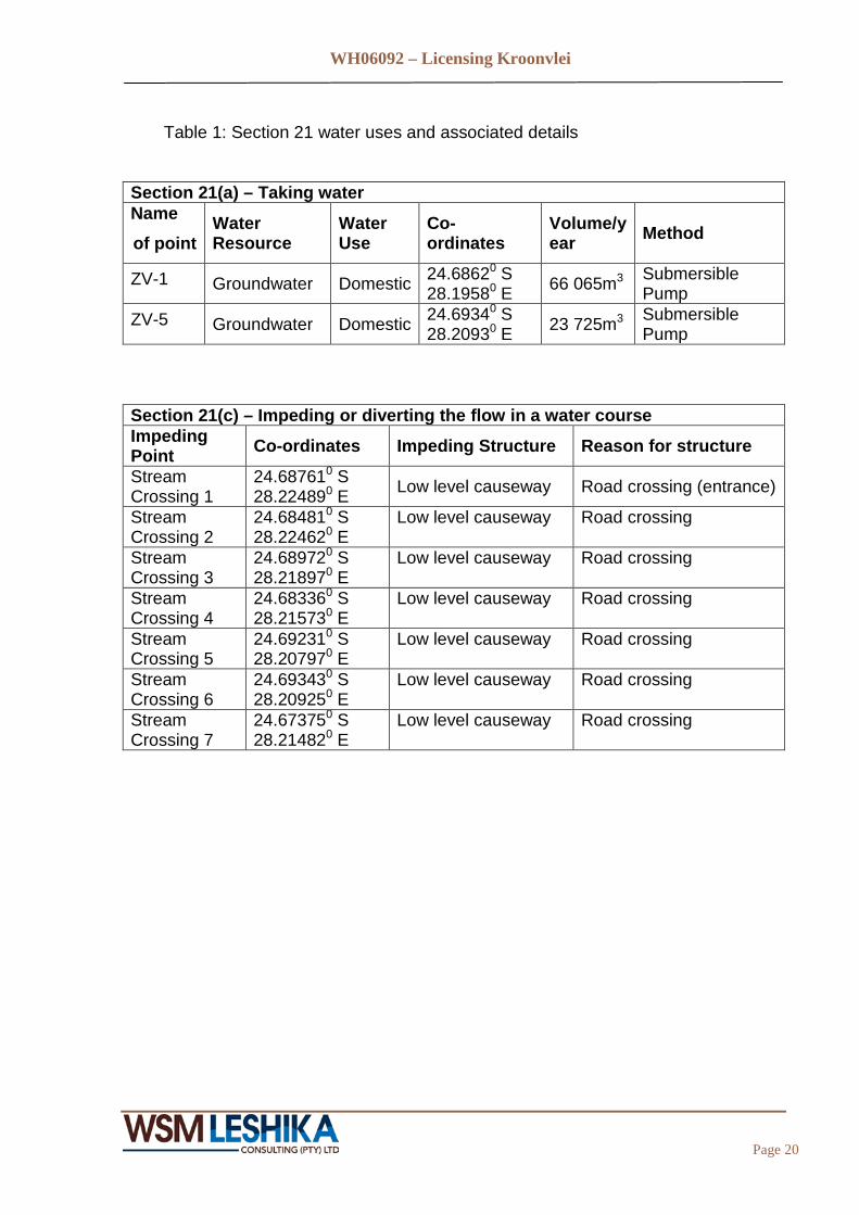
Table 1: Section 21 water uses and associated details
Section 21(a) – Taking water Name of point
Water Resource
Water Use
Co-ordinates
Volume/year Method
ZV-1 Groundwater Domestic 24.68620 S 28.19580 E 66 065m3 Submersible
Pump ZV-5 Groundwater Domestic 24.69340 S
28.20930 E 23 725m3 Submersible Pump
Section 21(c) – Impeding or diverting the flow in a water course Impeding Point Co-ordinates Impeding Structure Reason for structure
Stream Crossing 1
24.687610 S 28.224890 E Low level causeway Road crossing (entrance)
Stream Crossing 2
24.684810 S 28.224620 E
Low level causeway Road crossing
Stream Crossing 3
24.689720 S 28.218970 E
Low level causeway Road crossing
Stream Crossing 4
24.683360 S 28.215730 E
Low level causeway Road crossing
Stream Crossing 5
24.692310 S 28.207970 E
Low level causeway Road crossing
Stream Crossing 6
24.693430 S 28.209250 E
Low level causeway Road crossing
Stream Crossing 7
24.673750 S 28.214820 E
Low level causeway Road crossing

WH06092 – Licensing Kroonvlei
Page 21
Section 21(i) – Altering the beds, banks course or characteristics of a water course Impeding Point Co-ordinates Alteration Reason for alteration
Stream Crossing 1
24.687610 S 28.224890 E
Low level causeway through Bank and riverbed.
Road crossing (entrance)
Stream Crossing 2
24.684810 S 28.224620 E
Low level causeway through Bank and riverbed.
Road crossing
Stream Crossing 3
24.689720 S 28.218970 E
Low level causeway through Bank and riverbed.
Road crossing
Stream Crossing 4
24.683360 S 28.215730 E
Low level causeway through Bank and riverbed.
Road crossing
Stream Crossing 5
24.692310 S 28.207970 E
Low level causeway through Bank and riverbed.
Road crossing
Stream Crossing 6
24.693430 S 28.209250 E
Low level causeway through Bank and riverbed.
Road crossing
Stream Crossing 7
24.673750 S 28.214820 E
Low level causeway through Bank and riverbed.
Road crossing
Section 21(f) – Discharging waste or water containing waste into a water resource through a pipe, canal, sewer, sea outfall or other conduit. Discharge Point Location Type of waste Average volume
discharged per year Downstream of all houses
See figures 2 and 3
Treated sewage effluent. 10 698m3
Section 21(g) – Disposing of waste which may detrimentally impact on a water resourse. Waste generation Point
Location Type of waste Location of disposal
All houses See figures 2 and 3 Sewage Sludge. Modimolle Waste site
WH06092 – Licensing Kroonvlei
Page 22
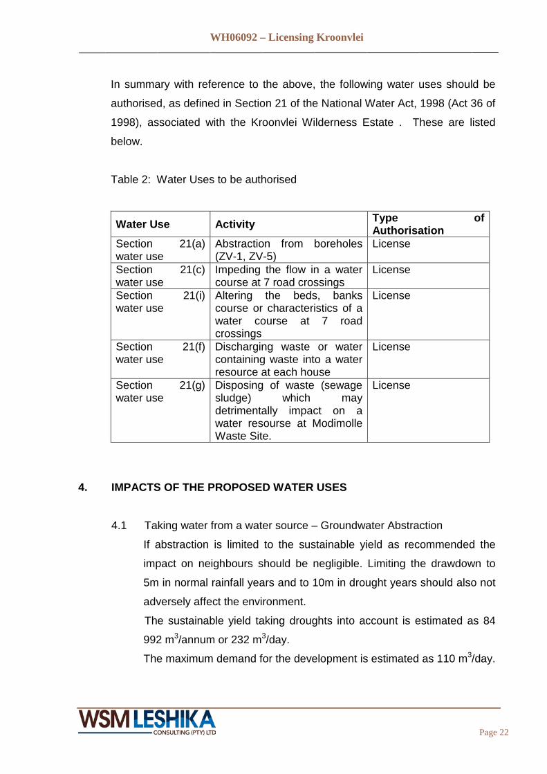
In summary with reference to the above, the following water uses should be
authorised, as defined in Section 21 of the National Water Act, 1998 (Act 36 of
1998), associated with the Kroonvlei Wilderness Estate . These are listed
below.
Table 2: Water Uses to be authorised
Water Use Activity Type of Authorisation
Section 21(a) water use
Abstraction from boreholes (ZV-1, ZV-5)
License
Section 21(c) water use
Impeding the flow in a water course at 7 road crossings
License
Section 21(i) water use
Altering the beds, banks course or characteristics of a water course at 7 road crossings
License
Section 21(f) water use
Discharging waste or water containing waste into a water resource at each house
License
Section 21(g) water use
Disposing of waste (sewage sludge) which may detrimentally impact on a water resourse at Modimolle Waste Site.
License
4. IMPACTS OF THE PROPOSED WATER USES 4.1 Taking water from a water source – Groundwater Abstraction
If abstraction is limited to the sustainable yield as recommended the
impact on neighbours should be negligible. Limiting the drawdown to
5m in normal rainfall years and to 10m in drought years should also not
adversely affect the environment.
The sustainable yield taking droughts into account is estimated as 84
992 m3/annum or 232 m3/day.
The maximum demand for the development is estimated as 110 m3/day.
WH06092 – Licensing Kroonvlei
Page 23
Based on the guidelines for groundwater abstraction this application
can be classified as a category A, i.e. small scale abstraction (<60%
recharge used on property). Based on the preliminary calculations
above, it may be concluded that there is sufficient rainfall recharge in
the sub-catchment to sustain the envisaged water supply of 110 m3/day
and that the impact will be minimal.
4.2 Disposing of waste water which may detrimentally impact on the water
resource
The sewage and wastewater will be treated in a closed system to DWA
standards. This treated effluent will then be released into the adjacent
streams.
As the soils in the area are sandy they would provide a good natural
filter and the treated effluent is therefore not expected to have a
significant impact on the water resources.
5. PUBLIC CONSULTATION
In summary, the following public consultation was undertaken as part of the
environmental scoping process:
• All adjacent landowners were contacted and provided with an information
letter of the proposed Kroonvlei Wilderness Estate Development
• Avertisement was placed in the local newspaper
No objections were received with regards to the proposed development.
6. LIST OF DOCUMENTS The following documents are attached:
- Appendix A: Correspondence with DWA
WH06092 – Licensing Kroonvlei
Page 24
- Appendix B: Surface Water Quality
- Appendix C: Hydrogeological Report
- Appendix D: Environmental Authorisation and Environmental
Management Plan
- Appendix E: Approval of the Development by the DFA Tribunal
- Appendix F: Authorities approvals
- Appendix G: Section 27 Motivation
- Appendix H: Proposed river crossing Designs
- Appendix I: DWA form 758
- Appendix J: Section 21(a) forms DW760, DW784, DW789
- Appendix K: Section 21(c) forms DW763
- Appendix L: Section 21(i) forms DW768
- Appendix M: Section 21(f) forms DW766
- Appendix N: Section 21(g) forms DW767
- Appendix O: Supplementary forms DW901, DW902, DW905
- Appendix P: Resolutions and ID documents
- Appendix Q: Koonvlei Wilderness Estate Land Owners Association
NPC registration documents
- Appendix R: Title Deeds

WH06092 – Licensing Kroonvlei
APPENDICES
WH06092 – Licensing Kroonvlei
APPENDIX A CORRESPONDENCE WITH DWA

WH06092 – Licensing Kroonvlei
APPENDIX B SURFACE WATER QUALITY

WH06092 – Licensing Kroonvlei
APPENDIX C HYDROGEOLOGICAL REPORT
WH06092 – Licensing Kroonvlei
APPENDIX D ENVIRONMENTAL AUTHORISATION AND ENVIRONMENTAL
MANAGEMENT PLAN
WH06092 – Licensing Kroonvlei
APPENDIX E APPROVAL OF THE DEVELOPMENT BY THE DFA TRIBUNAL

WH06092 – Licensing Kroonvlei
APPENDIX F AUTHORITIES APPROVALS

WH06092 – Licensing Kroonvlei
APPENDIX G SECTION 27 MOTIVATION
WH06092 – Licensing Kroonvlei
APPENDIX H PROPOSED RIVER CROSSING DESIGNS
WH06092 – Licensing Kroonvlei
APPENDIX I DWA FORM 758

WH06092 – Licensing Kroonvlei
APPENDIX J SECTION 21(A) FORMS DW760, DW784, DW789
WH06092 – Licensing Kroonvlei
APPENDIX K SECTION 21(C) FORMS DW763

WH06092 – Licensing Kroonvlei
APPENDIX L SECTION 21(I) FORMS DW768

WH06092 – Licensing Kroonvlei
APPENDIX M SECTION 21(F) FORMS DW766

WH06092 – Licensing Kroonvlei
APPENDIX N SECTION 21(G) FORMS DW767
WH06092 – Licensing Kroonvlei
APPENDIX O SUPPLEMENTARY FORMS DW901, DW902, DW905
WH06092 – Licensing Kroonvlei
APPENDIX P RESOLUTIONS AND ID DOCUMENTS
WH06092 – Licensing Kroonvlei
APPENDIX Q KOONVLEI WILDERNESS ESTATE LAND OWNERS ASSOCIATION
NPC REGISTRATION DOCUMENTS
WH06092 – Licensing Kroonvlei
APPENDIX R TITLE DEEDS