waterfront analysis - manorhaven.org manorhaven waterfront analysis 3... · contentious issue along...
TRANSCRIPT
Waterfront Analysis
for the
INCORPORATED VILLAGE
OF
MANORHAVEN
March 2018
Village of Manorhaven DRAFT Waterfront Analysis March 2018
Cameron Engineering & Associates, LLP ii
TABLE OF CONTENTS
1 INTRODUCTION .......................................................................................................................................... 1-3
1.1 MANORHAVEN WATERFRONT ADVISORY COMMITTEE ................................................................................ 1-4 1.1.1 Community Meetings ......................................................................................................................... 1-4 1.1.2 Waterfront Advisory Committee Input ............................................................................................... 1-5 1.1.3 Implementation of GIS Mapping ........................................................................................................ 1-6
2 ZONING RECOMMENDATIONS ............................................................................................................... 2-8
2.1 WATERFRONT .............................................................................................................................................. 2-8 2.1.1 Enhance Public Access ...................................................................................................................... 2-8 2.1.2 Regulate Bulk/Form along the Waterfront ...................................................................................... 2-11 2.1.3 Incorporate Low Impact Development Principles for Waterfront Districts .................................... 2-13 2.1.4 Provide Incentives for Desirable Land Uses and Public Amenities on the Waterfront ................... 2-13 2.1.5 Develop Architectural Design Standards ........................................................................................ 2-14 2.1.6 Utilize the Village Architectural Review Board for all Waterfront Projects ................................... 2-14 2.1.7 Amend Regulations for Existing Districts ........................................................................................ 2-15
3 CONCLUSIONS AND NEXT STEPS ........................................................................................................ 3-16
TABLES OF FIGURES
FIGURE 1-1: UPDATED VILLAGE ZONING MAP/GIS DATABASE .................................................................................... 1-7 FIGURE 1-2: ONGOING CCTV SEWER SYSTEM EVALUATION/GIS DATABASE ............................................................... 1-8 FIGURE 1-3: ONGOING ROAD EVALUATION SURVEY/CAD-GIS DATABASE .................................................................. 1-8
APPENDICES
APPENDIX A
Village of Manorhaven DRAFT Waterfront Analysis March 2018
Cameron Engineering & Associates, LLP 1-3
1 Introduction
In June 2016, the Village of Manorhaven enacted a temporary building moratorium
(hereinafter the ‘Moratorium’) that affects properties located along its waterfront, including
the following districts: C-1 Commercial, E-1 Enterprise, R-1 Residential, R-3 Residential, R-4
Residential, MP Marine Preservation and MR Marine Recreation. Ultimately, this study will
help to guide the Village as it transitions away from the Moratorium by providing a more
sustainable concept of public access and waterfront uses within the community. This
analysis may result in amendments to the Village Code (specifically to Chapter 155 –
Zoning). In addition, through the development of an updated, Geographic Information
Systems (GIS)-based database and zoning map, the Waterfront Analysis provides
supportive framework, should the Village decide, to implement and manage an updated
Code.
Cameron Engineering and
Associates, LLP was retained by the
Village to assess existing conditions
including proposed private
developments, attend Waterfront
Advisory Committee meetings to
understand issues, goals, needs and
opportunities, provide examples of
code modifications that focus on
public access/preservation of open
space, and obtain additional input
from a public, open-house event. The
public would also have an
opportunity to provide input as any
zoning-related action proposed by
the Village would be referred to the Nassau County Planning Commission for review. Finally,
additional public hearings and opportunities for public input would be provided as the Village
moves through the State Environmental Quality Review Act (SEQRA) process, which is a required
environmental analysis that would be required for any amendments to the Village Code,
comprehensive master plan or future local waterfront revitalization program.
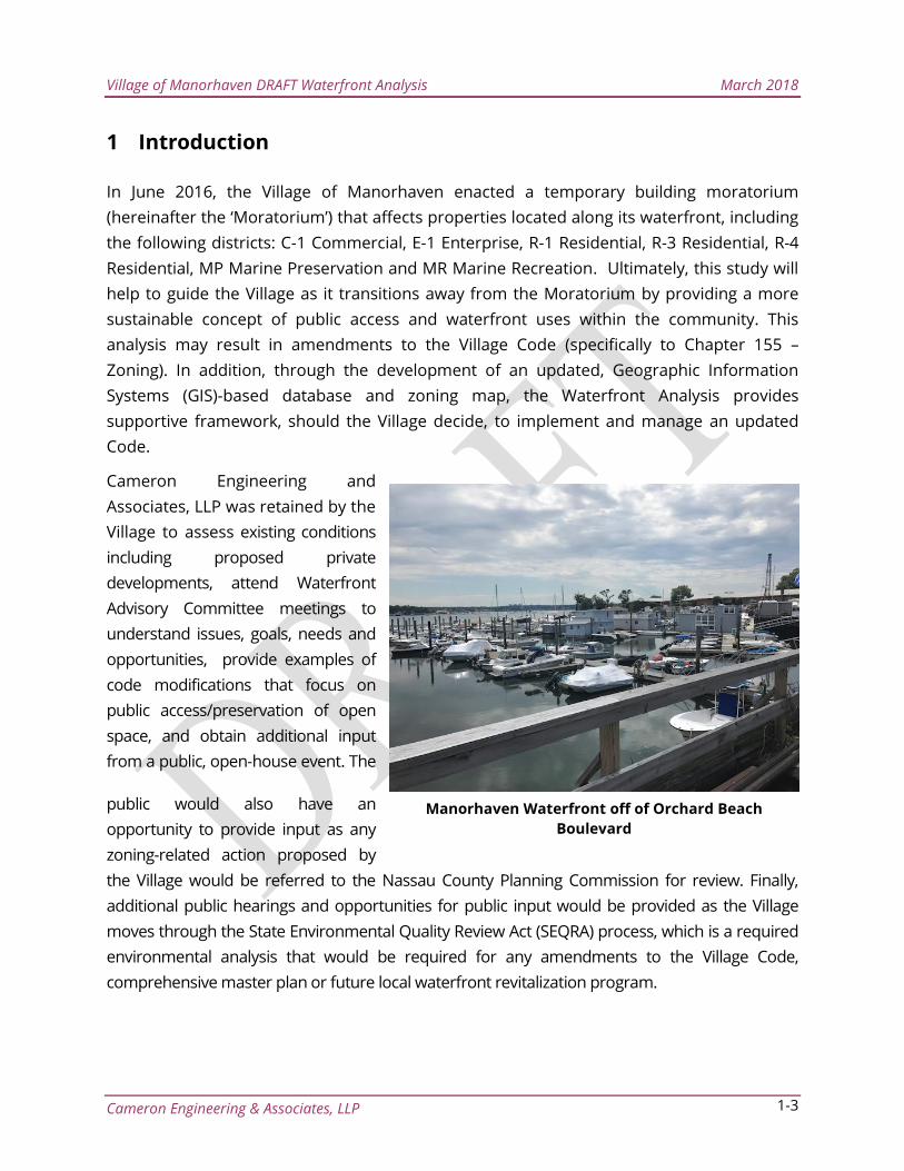
Manorhaven Waterfront off of Orchard Beach
Boulevard
Village of Manorhaven DRAFT Waterfront Analysis March 2018
Cameron Engineering & Associates, LLP 1-4
1.1 Manorhaven Waterfront Advisory Committee
In June 2016, the Mayor and Village of Manorhaven Board of Trustees re-instated a
Manorhaven Waterfront Advisory Committee. In September 2016, the Village set
forth an official policy regarding waterfront development and the transition away
from the Moratorium:
"The Village of Manorhaven welcomes input from all Village residents as it
considers how best to regulate development of waterfront properties. Our
goal is to balance the interests of the community with the rights of
property owners. To help accomplish this goal, I have appointed an
advisory committee to review the Village's comprehensive master plan,
local waterfront revitalization plan, and zoning code, and to make
recommendations for consideration by the Board of Trustees. Only the
Board of Trustees has the authority to adopt Village laws regulating
waterfront development. Before the Board of Trustees takes any action, it
will publish a notice in the Port Washington News and will conduct a
public hearing. At the hearing, all interested Village residents will have an
opportunity to express their views directly to the Board of Trustees."
The Committee includes residents, local business owners, and municipal
representatives with direct ties to and knowledge of the Manorhaven waterfront.
Ultimately, the Committee was tasked with studying the issues and potential
impacts associated with the Moratorium and presenting both their expertise and
research findings at a series of community meetings.
1.1.1 Community Meetings
The Waterfront Advisory Committee has met regularly throughout 2016 and 2017 –
including both internal working sessions and special community meetings. These
community meetings were held to allow members to share the findings and
concerns of the Waterfront Advisory Committee with the Village Board of Trustees
and to gather additional public feedback.
Given the diverse representation of stakeholders on the Committee, these
community meetings provided valuable perspective into the nuances of waterfront
development and potential impacts on the community. At the center of debate, the
most fundamental issue is finding the correct balance between preservation of
Manorhaven’s natural beauty/character and the rights of local property owners.
Village of Manorhaven DRAFT Waterfront Analysis March 2018
Cameron Engineering & Associates, LLP 1-5
At the July 13, 2017 community meeting, Mayor Avena reaffirmed that the goal of
the Committee’s work – and the outcome of this process – is not to discuss specific
development proposals – but rather to create a vision for the future of the
waterfront. The Committee must articulate this vision to the Board of Trustees and
ensure that any changes to the Village Code, comprehensive master plan and/or
future local waterfront revitalization program work to advance this vision forward.
1.1.2 Waterfront Advisory Committee Input
With this goal of creating a future vision for the waterfront, both the public and
Committee members emphasized the importance of recognizing the Village’s
maritime roots. The concepts of Village character and cohesion along the waterfront
were discussed along with the need for improved architectural guidelines for new
projects. While several community members presented different perspectives about
the Village, nearly all meeting participants referenced the importance of the Village’s
maritime history and the natural beauty of the waterfront and Manhasset Bay.
As meetings progressed and more specific ideas came forward, community meeting
participants expressed a strong desire to preserve water views, create more open
space for public use, provide better pedestrian access and amenities, discourage
visual barriers (i.e., “walls” of apartments/condominiums), and more landscaping.
Establishing a continuous walkway or promenade along the waterfront was well
supported. Nearby Bay Walk Park provides a local example of the type of publicly-
accessible waterfront that could be created in Manorhaven. Better connections
between upland areas and the waterfront were also mentioned consistently.
Concerns were expressed particularly over residential development on the
waterfront. Most participants felt that the existing condominium/apartment/cluster
housing developments on the waterfront detracted from both the Village’s character
and the community’s use/enjoyment of the waterfront. As such, the issue of
converting former marine-dependent uses (i.e., marinas) to housing has become a
contentious issue along the waterfront. While many expressed a strong desire to
retain marinas and other maritime uses, some participants also stated that current
market and environmental conditions are threatening the viability of many of these
businesses.
One of the contributing factors to residential development pressures on the
waterfront is the presence of commercial/industrial uses and irregularly-assembled
parcels located just upland (primarily within the E-1 district on Manhasset Isle). Even
with code changes, the development of housing in these portions of Manhasset Isle
Village of Manorhaven DRAFT Waterfront Analysis March 2018
Cameron Engineering & Associates, LLP 1-6
would be nearly impossible (due to the aforementioned site constraints and
presence of incompatible industrial uses). This creates a very high demand for
residential property – and an even larger premium on larger lots which could be
developed into housing in the future. In Manorhaven’s case, most of these larger
lots are located along or adjacent to the waterfront.
Others expressed concerns about too many uses being permitted within waterfront
districts. The E-1 District, in particular, currently allows for large-scale uses such as
hotels and self-storage facilities – both of which were identified by Committee
members as undesirable uses for the waterfront area.
1.1.3 Implementation of GIS Mapping
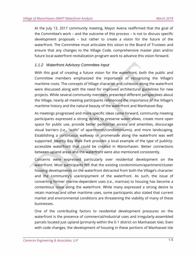
As part of this analysis, an updated, digital Zoning Map and Village-wide parcel
database were created using Geographic Information Systems (GIS) to assist the
Village with zoning and land use issues. Digital conversion of the Village’s record
keeping systems into digital format allows easier and more reliable access and
archiving. The Village’s GIS can be used in support of Village planning activities as a
reference tool to evaluate projects by providing information on local context such as
zoning, adjacent land uses, affected parcels, topography and proximity to sensitive
land uses (i.e., cultural/historic, environmental and institutional). As an example of
potential GIS applicability, the Village’s recently-adopted Local Law 23-2017 (adopted
September 28, 2017) concerning illegal occupancies, could be tracked and updated
through this GIS zoning and land use database.
Village of Manorhaven DRAFT Waterfront Analysis March 2018
Cameron Engineering & Associates, LLP 1-7
Figure 1-1: Updated Village Zoning Map/GIS Database
Village of Manorhaven DRAFT Waterfront Analysis March 2018
Cameron Engineering & Associates, LLP 2-8
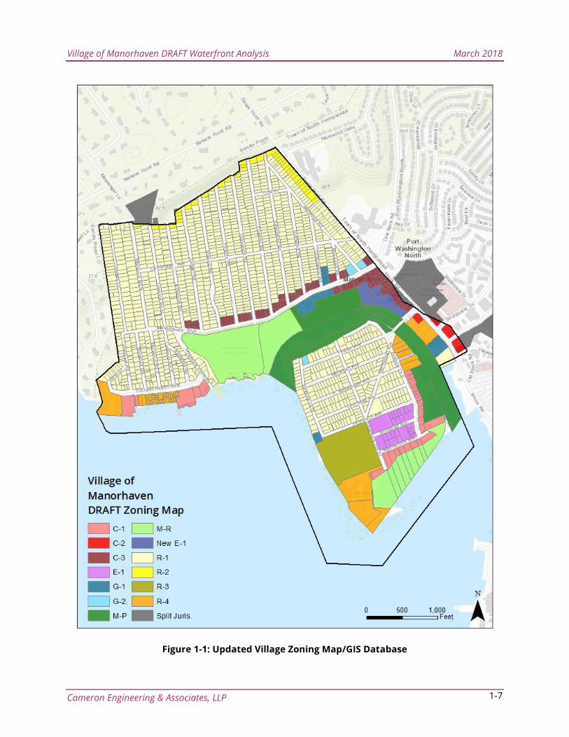
This GIS inventory could also be
expanded to include other municipal
systems – such as water and sewer
systems, street lights, natural resources
and transportation infrastructure (i.e.,
road condition database). Such a
database could function as an
important tool in managing future
capital and maintenance needs. It
would also interface well with several of
the Village’s ongoing capital projects
(i.e., sewer system analysis and road
conditions analysis) – allowing for real-
time field updates and integration with
Computer-Aided Design (CAD) files. This
type of database is extremely valuable
as it provides the framework for more
advanced design analyses, such as the
use stormwater or sewer system
modeling software. A functional GIS
database would also allow the Village to
quickly assess the impact of Town,
County, State and Federal
regulations/activities on the local community.
2 Zoning Recommendations
2.1 Waterfront
2.1.1 Enhance Public Access
As discussed in the community engagement section, public access and use of
Manorhaven’s waterfront is of principal concern to the community. Access to the
waterfront is a major reason why many choose to live in and visit the Village of
Manorhaven. The Village is fortunate to have many public facilities in close proximity
to the waterfront/Manhasset Bay – most notably the Manorhaven Beach Park and
Pool, which is centrally-located on the Village’s waterfront. Although the Town of
North Hempstead maintains this nearly 35-acre facility, it is easily accessible to
Figure 1-2: Ongoing CCTV Sewer System
Evaluation/GIS Database
Figure 1-3: Ongoing Road Evaluation
Survey/CAD-GIS Database
Village of Manorhaven DRAFT Waterfront Analysis March 2018
Cameron Engineering & Associates, LLP 2-9
Village residents and area visitors. However, outside of this park, Morgan’s Dock and
a select few access points, access to the Manorhaven waterfront is significantly
hampered by private developments and discontinuous public pathways. Bay Walk
Park, which is located just outside of the Village boundaries, provides a good
example of the type of public access and circulation that the community envisions
for the Manorhaven waterfront.
The existing zoning framework, particularly for the zoning districts included in the
Moratorium, results in land uses that provide neither adequate public access/views
nor the ability for private owners to redevelop their properties in a way that is
consistent with the public’s vision for the Manorhaven Waterfront. The following
recommendations aim to address this issue:
POTENTIAL ACTION ITEMS
Consider requiring that public easement or public access amenities are
included in all new waterfront developments. Ultimately, these public access
requirements could be enacted through a Waterfront Overlay District. The
Waterfront Overlay District would only apply to developments that have
agreed to provide and dedicate an easement for publicly accessible open
space. Waterfront Overlay District could be applied, at the discretion of the
Village Board of Trustees, in the C-1, R-3, R-4 and MR zoning districts1.
o For development parcels (or assemblages of parcels) greater than one
acre in size, continuous linear waterfront public open space located
parallel and adjacent to the shore should be provided. A small, no-
build area adjacent to these open spaces would ensure privacy and a
transition between private and public uses.
o In addition to waterfront open space areas, upland connections could
be required to allow access from the roadways and/or other public
areas to the waterfront.
o For smaller parcels where a continuous waterfront area is not
feasible, property owners could contribute to a waterfront fund for
maintenance of public spaces based on a percentage of construction
cost.
1 Note that the E-1 district, can be developed under the existing Business Overlay District (BOLD) provisions –
which allows for mixed-use and multi-family residential development. The E-1 district is somewhat restricted in
terms of existing parcel layouts (many small/irregular lots) and lacks a true waterfront area. As such, the provisions
of the Waterfront Overlay District would not be applied for this district. However, potential amendments to the E-1
are provided in Section 2.1.7 to provide for additional open space.
Village of Manorhaven DRAFT Waterfront Analysis March 2018
Cameron Engineering & Associates, LLP 2-10
o Publicly accessible open spaces and upland connections could be
dedicated to the Village (or another public entity). However, any area
dedicated for purposes of public access would still be included in any
calculation to determine overall development potential.
o The majority of the MR district includes areas that could not be
developed – including open water/underwater lands and municipal
parkland. The upland portions of the MR district could be included
within the Waterfront Overlay District, which would help to increase
public access and enjoyment of the waterfront. As it exists today,
much of the MR district is located on the waterside of private
businesses – effectively limiting public access to the waterfront.
o Although the R-1 district was included in the Moratorium, the
Waterfront Overlay District provisions would not apply to this zoning
district. The R-1 district (including the waterfront area on Manhasset
Isle) includes established single-family neighborhoods that should be
preserved.
o The MP district was also included in the Moratorium but again, the
provisions of the Waterfront Overlay District would not be applicable
in this district – as housing is not permitted within this district and the
Village intends to preserve these open space/natural areas for public
enjoyment.
An additional mechanism, which is utilized in the Zoning Resolution of New
York City (Article VI: Special Regulations Applicable to Certain Areas, Chapter 2 -
Special Regulations Applying in the Waterfront Area), is the provision in the code
for the creation of a Waterfront Access Plan (WAP). The Village may update its
Code to improve regulation of waterfront development, adding a provision
for Waterfront Access Plans allowing additional control over waterfront
development as market or environmental conditions change (i.e., wetland
migration, sea-level rise, presence of hazardous materials). For the Village of
Manorhaven, such a provision could act as an additional or supplemental
regulatory tool and ensure that waterfront development continues to adapt
as local conditions change and evolve. In this way, a WAP could act as a more
detailed, site-specific approach to managing future waterfront development
– particularly for sites with unique challenges. Given the concerns about
some of the larger development sites within the Village, this level of oversight
could ensure that public access is a major feature of any large development.
Village of Manorhaven DRAFT Waterfront Analysis March 2018
Cameron Engineering & Associates, LLP 2-11
2.1.2 Regulate Bulk/Form along the Waterfront
In addition to enhancing public access and use of the waterfront, zoning must
effectively regulate the bulk, form, and design elements of any proposed
development. Community members have indicated that several of the existing
residential developments along the waterfront have created significant visual
impacts for the Village. The Village and many of its residents have a strong
connection to the waterfront and the preservation of this connection – whether
physically or aesthetically - is critical moving forward. As a relatively compact and
densely populated Village (approximately three times greater than overall
population density of Nassau County), any obstruction of waterfront viewsheds
results in significant impacts to the rest of the community. While the consideration
of changes to allowable height may be controversial, if permitted in combination
with additional siting regulations, such a change could help to preserve views more
effectively than some of the existing multi-family developments in the Village
(several of which were cited by residents as undesirable examples of development).
In general, this type of design would result in smaller overall building footprints,
which would also have positive environmental benefits (i.e., reduced land
disturbance, improved stormwater management, preservation of natural areas).
The allowance of increased height is also a key step in designing residences to be
more flood-resistant and resilient in the face of coastal storms/sea-level rise.
Although this specific concern was not discussed in great detail at community
meetings, as a relatively low-lying coastal community, Manorhaven should strongly
consider any regulatory tool that reduces impacts from coastal hazards and
improves community resilience.
The following potential action items represent key considerations/initial steps
towards effective bulk/form regulation – designed with the goal of preserving
Manorhaven’s maritime connection.
POTENTIAL ACTION ITEMS
To preserve views and incorporate public access, overall residential density
within the Waterfront Overlay District could be restricted to one unit per
3,000 SF (approximately 15 units per acre) of lot area.
This level of residential density is less dense than the current density
established by the R-4 district (one unit per 1,500 SF of lot
area/approximately 29 units per acre, but limited to a maximum of 20 units).
At the discretion of the Village Board of Trustees, this overlay could be
Village of Manorhaven DRAFT Waterfront Analysis March 2018
Cameron Engineering & Associates, LLP 2-12
applied in the C-1, R-3, R-4 and MR districts (where residential development is
either restricted by dimensional requirements or not currently permitted).
o Density greater than 15 units per acre can be problematic for smaller
development sites without adequate open space – resulting in
developments with high percentages of lot coverage, compromised
views and limited public access.
o The current method of regulating residential density also fails to tie
the level of density/development to the lot size – creating a one-size-
fits-all approach to a unique and somewhat irregular waterfront.
As described in Section 2.1.1 above, any development utilizing the Waterfront
Overlay District should dedicate a portion of the lot area to provide usable
public open space as part of any new waterfront development. While these
areas would be dedicated to the Village (or another public entity), they would
still be included in any calculation to determine overall development
potential of a site.
o This open space could be created by transferring existing setback
requirements (e.g., C-1 district requires five-foot front yard setbacks
and 10-foot rear yard setbacks) to the public open space area, thus
creating a 10-foot public open space area along the waterfront (with a
five foot buffer between public/private areas).
o Upland connections could be required at a minimum width of five
feet.
Consider increasing allowable height for properties utilizing the Waterfront
Overlay District to 34 feet/three stories. In general, development is limited to
two stories/26 feet in height (28 feet within the R-4 zoning district) within the
zoning districts included in the Moratorium. This slight increase in height
could help to reduce building footprints, preserve viewsheds, increase open
space and improve stormwater management. At the same time, it could
allow property owners slightly more flexibility in terms of the overall design
and layout of their development.
Consider establishing minimum standards for all public access areas
regulating dimension, paving, seating, landscaping, lighting, signage and
other amenities to ensure the quality of public open space.
Consider establishing minimum standards for visual corridors to provide
unobstructed waterfront views. Visual corridors do not need to be publicly
accessible areas, yet they are vital to the public’s use and enjoyment of the
waterfront. The Waterfront Overlay District could require open vistas at a
minimum width of 25 feet – particularly from any roadway or public area.
Building frontages could be limited to a maximum of 50 feet.
Village of Manorhaven DRAFT Waterfront Analysis March 2018
Cameron Engineering & Associates, LLP 2-13
2.1.3 Incorporate Low Impact Development Principles for Waterfront Districts
Any redevelopment of the Waterfront should incorporate the least environmentally
disruptive methodologies possible. The Village could ensure that any new
development incorporates additional landscaped areas made up of both green
zones and plazas with pervious materials. Stormwater runoff would be directed into
natural swales, rain gardens, and planted drainage recharge areas wherever
possible. These low impact development (LID) principles can be very effective in
transforming areas that are traditionally hardscape/impervious surfaces (i.e.,
parking areas). Such an approach could improve the visual quality of the area while
significantly improving stormwater management and water quality.
Updated landscaping requirements, focusing on the use of native plants should also
be considered. Native plants require less water, fertilizer, and pesticide use than
exotic and ornamental plants. The Village should consider requiring the use of
native grasses, shrubs, and trees that are adapted to seaside areas for any new
Waterfront project.
POTENTIAL ACTION ITEMS
Consider requiring waterfront development to reduce pavement, increase
infiltration, and utilize techniques that direct stormwater into natural
vegetated areas.
Consider requiring the use of native plants to reduce water use and eliminate
fertilizer and pesticide use on the waterfront.
2.1.4 Provide Incentives for Desirable Land Uses and Public Amenities on the
Waterfront
To be successful, the future Manorhaven waterfront should include improvements
to the streetscape, new public pathways/access points, recreational and cultural
facilities, and community parking facilities. To implement these improvements, the
Village could consider developing a waterfront-specific, incentive-based mechanism
for creating, preserving, and enhancing public spaces. Regardless of the
community’s different opinions regarding future development on the waterfront,
the community clearly demonstrated consensus for increased public access and
space. The creation of new, public open space would require private property
owners to dedicate a portion of their property towards this open space. Thus, an
incentive mechanism, focused on public access and amenities, could be established
and codified.
Village of Manorhaven DRAFT Waterfront Analysis March 2018
Cameron Engineering & Associates, LLP 2-14
The Village should investigate the availability of grants, alternative financing sources,
development bonuses, and other mechanisms to make some of the improvements
necessary for the redevelopment of the waterfront.
POTENTIAL ACTION ITEM
Consider establishing an additional density incentive bonus for property
owners/developers who provide greater than 20% of total lot area in the
form of publicly accessible open space. Utilizing this bonus could allow a
property owner to increase overall density from 15 to 20 units per acre. This
density incentive is equal to the level of development currently permitted
within the R-4 zone of 20 units total per lot on a small lot.
2.1.5 Develop Architectural Design Standards
Redevelopment in the Village can introduce different architectural design elements
for each new development proposed. Although different styles can work well
together, it is important to retain an overall look that reflects the community’s vision
for the waterfront.
The Architectural Review Board should develop a set of design standards that
recognizes Manorhaven’s maritime history and culture. Architectural standards
could include requirements for the streetscape in front of new developments,
building facades, mass, fenestrations, articulations, and roofs. Special consideration
should be given to preserve waterfront views and ensure that natural resources are
not adversely impacted by future development.
POTENTIAL ACTION ITEMS
Consider preparing an updated Architectural Design Standards Manual.
Consider requiring new development and substantial redevelopment to
conform to the Architectural Design Standards Manual minimum
requirements.
2.1.6 Utilize the Village Architectural Review Board for all Waterfront Projects
For potential waterfront projects, the Village’s Architectural Review Board (ARB)
could offer better protection of waterfront properties – especially in terms of
preserving the Village’s maritime character and ensuring architectural consistency.
Given the community’s emphasis on aesthetics and views along the waterfront, the
ARB could play a major role in implementing the community’s vision for the
waterfront.
Village of Manorhaven DRAFT Waterfront Analysis March 2018
Cameron Engineering & Associates, LLP 2-15
An active and effective ARB supplements the proposed amendments to waterfront
zoning districts. While zoning is principally concerned with land use regulations and
designed to protect public health, safety and general welfare – the ARB can act as an
additional tool to specifically address many of the aesthetic/visual quality issues
raised by community members.
POTENTIAL ACTION ITEMS
In addition to waterfront properties, the Village Board of Trustees could
determine which zoning districts would require review by the Village
Architectural Review Board. Based on the districts affected by the
Moratorium, these districts could include the C-1 Commercial, E-1 Enterprise,
R-1 Residential, R-3 Residential, R-4 Residential, MP Marine Preservation and
MR Marine Recreation districts. Although the MP does not permit any type of
housing, architectural standards should be maintained – even for public-
oriented recreation/conservation facilities.
Consider requiring review by the ARB for construction, substantial
remodeling, and demolition work for any property located along the
waterfront (or within the affected districts, as specified above).
2.1.7 Amend Regulations for Existing Districts
In addition to the Code changes that could be enacted through the establishment of
the Waterfront Overlay District, the following recommendations are provided to
further advance the public’s vision for the Manorhaven waterfront. Several of these
recommendations came directly from the public during meetings of the Waterfront
Committee, while others were developed after careful analysis of existing
zoning/development conditions in the Village:
POTENTIAL ACTION ITEMS
E-1: Consider removing hotels and self-storage facilities from the list of
permitted uses (§155-23 A (7) (20)). Additional recommendations are
provided below for the Business Overlay District (BOLD), which principally
affects the E-1 district.
BOLD: The BOLD is currently applicable within the C-1, C-2, C-3 and E-1
districts (C-2 and C-3 districts are located outside of the waterfront
Moratorium area). The existing BOLD district permits mixed-use
development within the E-1 district, however, the existing BOLD open space
requirements do little to help preserve views in the vicinity of the waterfront.
If/when redevelopment occurs within the E-1 district, viewsheds could be
preserved by modifying §155-20.1 F (1) to state that the open space
Village of Manorhaven DRAFT Waterfront Analysis March 2018
Cameron Engineering & Associates, LLP 3-16
requirement in the E-1 district is 25% and may not be reduced. For
residential uses, setbacks could be provided in the form of landscaped front
yards.
R-3: Although there is only one large development site zoned R-3 in the
Village, preservation of waterfront views and the provision of public access
could be added to the regulations of the R-3 district. A minimum of 25-foot
open vistas could be provided throughout the site, including views from
existing (and future) roadways. Publicly-accessible open space should be
provided throughout the site, including a minimum waterfront area with a
depth of 10 feet and upland connections with a minimum width of 5 feet. If
feasible, these upland connections could be shared between neighboring
properties. These publically accessible areas would require public easement
dedication to the Village (or another public entity). However, these areas
could still be used to calculate overall development potential of the site.
R-4: Consider amending the base density requirements set forth in §155-16 B
(1), which establishes the “minimum lot area for an apartment house shall be
1,500 square feet per family and shall not contain more than 20 apartments.”
This could be amended to remove the 20 apartment maximum restriction
(which could result in the overdevelopment of small sites while significantly
limiting the development potential of larger sites). 1,500 SF per family
equates to an approximate population density of 29 units per acre. Within
the R-4 district, the base density could be reduced to 3,000 square feet per
family (approximately 15 units per acre), with density increases permitted for
developments that provide more than 20% of lot area in the form of publicly
accessible open space. Overall density increases could be capped at 20 units
per acre.
3 Conclusions and Next Steps
This Waterfront Analysis provides the framework necessary for the Village Board of
Trustees to consider zoning amendments to the Village Code. Any changes to the Code
must work to balance public and private interests – however, the recommendations
provided within this Analysis are crafted around the principle goals of increasing public
access and preserving views along the Manorhaven waterfront. The existing zoning
regulations have resulted in a pattern of development that is unsuitable for a compact
waterfront community. The proposed Waterfront Overlay District could allow for
development that enhances the public’s access and use of the waterfront while also
allowing property owners additional options for their properties. The underlying zoning,
including the legislative purposes of each district, would be maintained within the Code.
Village of Manorhaven DRAFT Waterfront Analysis March 2018
Cameron Engineering & Associates, LLP 3-17
The C-1 district, in particular, includes a legislative purpose (§155-18 A. (1-4)) that focuses
on the importance of the Village’s maritime heritage and public access and enjoyment of
the waterfront. It states:
A. Legislative purpose. The purpose of this section is to:
(1) Ensure that the character and integrity of Manorhaven's maritime
heritage, particularly the concentration of water-dependent uses in the
area which is unique to the Village of Manorhaven and the entire Long
Island Sound region, will be maintained and enhanced.
(2) Maintain, encourage and promote the development of uses that have
traditionally been associated with the Village of Manorhaven waterfront
and to accommodate water-enhanced commercial uses that are
compatible with and supportive of water-dependent uses.
(3) Expand, enhance and preserve the public's ability to access a limited
deep-water resource for commercial and recreational uses and
enjoyment, and maximize employment opportunities from water-
dependent commerce.
(4) Provide for waterfront amenities for public enjoyment of the shore.
This legislative purpose helped to guide the recommendations of this Analysis – with the
Waterfront Overlay District designed to further advance these goals.
The process for amending the Village Code will include drafting new code
sections/amendments, hosting a public meeting (in addition to regular meetings of the
Village Board of Trustees), initiating the State Environmental Quality Review Act (SEQRA)
process, referring the proposed action to the Nassau County Planning Commission (NCPC)
and finally adopting the proposed Code changes (by decision of the Village Board of
Trustees). Throughout this process, public participation and feedback will help to further
refine the proposed Code changes. In addition to a special public meeting dedicated to the
waterfront Moratorium and regular Village Board of Trustees meetings, the public will be
able to comment and participate throughout the SEQRA and NCPC processes.
Overall, the potential action items included in this Waterfront Analysis would not introduce
drastic changes to overall height, density or land uses along the waterfront. However, small
changes to the Code, along with amendments focusing on public access and viewsheds,
could allow the future Manorhaven waterfront to fulfill the community’s vision for their
most valuable asset.
Village of Manorhaven DRAFT Waterfront Analysis March 2018
Cameron Engineering & Associates, LLP 3-18
Appendix A
Resolution # 45-2016 to Adopt Local Law #7 - 2016
June 22, 2016
A Local Law To Establish A Temporary Building Moratorium In
Certain Zoning Districts Within The Village