waterfront heritage handout
TRANSCRIPT

Alexandria Waterfront Heritage
The figure above is a 1748 map of the planned site for the town of Alexandria
The grainy portion of this 1749 map represents the area which was to be filled. Along the side is a list of the owners of the numbered lots.
The 1864 bird’s eye view and the 1877 Hopkins map show the importance of the waterfront as it grew and expanded.
Office of Historic Alexandria Alexandria Archaeology, 2006
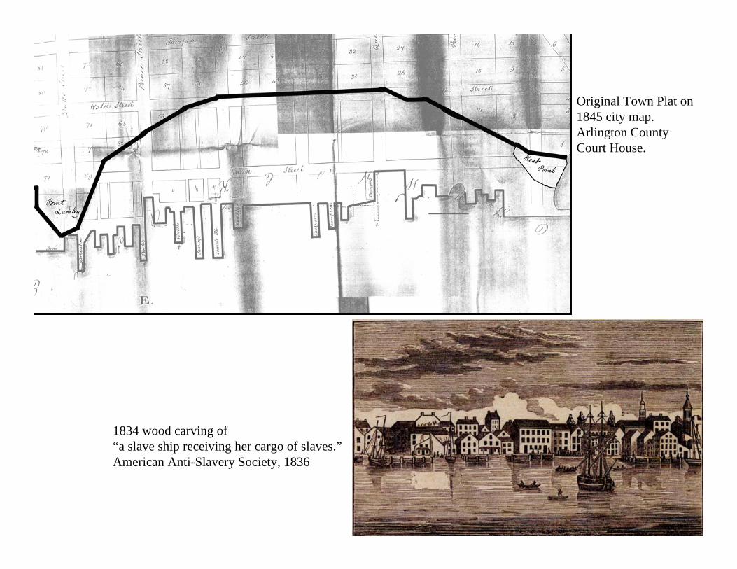
1834 wood carving of “a slave ship receiving her cargo of slaves.”American Anti-Slavery Society, 1836
Original Town Plat on 1845 city map. Arlington County Court House.
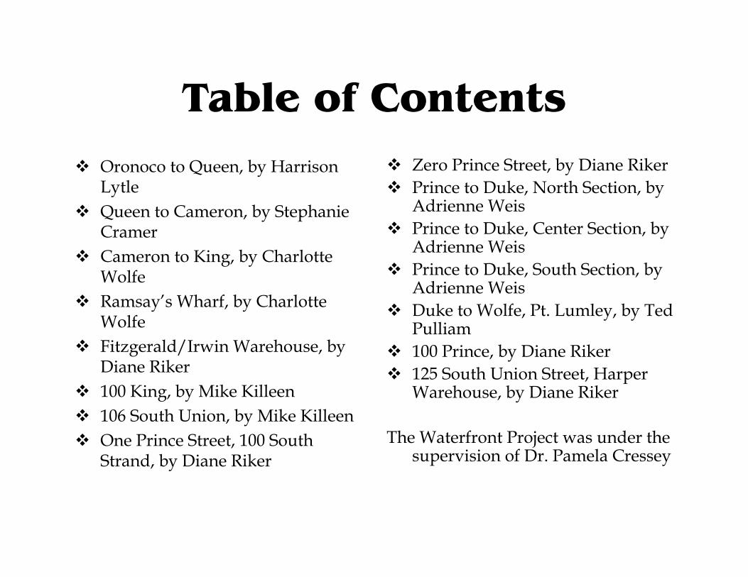
Table of ContentsOronoco to Queen, by Harrison LytleQueen to Cameron, by Stephanie CramerCameron to King, by Charlotte WolfeRamsay’s Wharf, by Charlotte WolfeFitzgerald/Irwin Warehouse, by Diane Riker100 King, by Mike Killeen106 South Union, by Mike KilleenOne Prince Street, 100 South Strand, by Diane Riker
Zero Prince Street, by Diane RikerPrince to Duke, North Section, by Adrienne WeisPrince to Duke, Center Section, by Adrienne WeisPrince to Duke, South Section, by Adrienne WeisDuke to Wolfe, Pt. Lumley, by Ted Pulliam100 Prince, by Diane Riker125 South Union Street, Harper Warehouse, by Diane Riker
The Waterfront Project was under the supervision of Dr. Pamela Cressey

Oronoco to Queen1748 “Plat of the Land where on Stands the Town of Alexandria,” Library of Congress.
Above: 1746 Survey block. Alexandria Library, Special Collections.
Left: Workers salting fish. Alexandria Library Special Collections, William Smith Collections.
1877 G.M. Hopkins Map

Oronoco to Queen• Colonial
West Point was founded as an inspection station on a 220 acre plot of land and was willed to John and Hugh West, who built a tobacco house in 1732. Lot 7 was not sold as a individual property and incorporated into Lot 8 and sold on May 8, 1768 to Isaac Hughes. Kirkpatrick's import of a ‘Parcel of very healthy Gambia slaves at the foot of Queen Street. Post RevolutionaryThe lot was sold and deeded to family members of John Allison who bought it from Hughes and constructed a pier and wharf in 1796. Albert West (son of Hugh West) is frequently absent from his land during the revolutionary war, which accounted for West End’s eventual sale due to Albert West monetary woes.
• Early 19th CenturyThe early 1800’s fish wharfs and storehouses were common place along the waterfront and largely contributed to the bustling port economy of Alexandria. It was also the sight of the notorious ‘fish town’, a seasonal community of African American wharf laborers who would inhabit a make shift shantytown village
• Civil WarThe Union Army occupied the waterfront and used the wharfs for shipping and receiving goods from the Potomac. ‘
• Late 19th Century1891 William A. Smoot was heavily invested in the water front between Queen and Oronoco. He owned wharfs and a coal and lumber yard that stretched from Oronoco, to Wheat's Wharf, just before Queen St.
• Early 20th CenturySmoot was still a major player on the waterfront and transformed the fertilizer and fish warehouses existing along N. Union St. into large coal and lumber yards.
• TodayFounders Park exists where the Smoot coal and lumber yards used to be and is directly across from homes and residential space. The industrial presence that once was prominent is all, but gone, only Robinsons Terminal Warehouse serves in such a capacity currently and stands almost directly where the West tobacco house stood in 1732.
West Point was the first important European settlement along the waterfront and predates the city of Alexandria, the warehouse that was constructed in 1732 was the first permanent substantial structure established on the waterfront and led to the founding of the town.William A. Smoot was a major player in the waterfront of Alexandria and politics in the city. He was elected Chairman and Mayor of Alexandria in 1922. His coal and lumber yard he owned stayed in the family until the 1960’s, when it was sold by his grandson Albert A. Smoot.
(Alexandria Library, Special Collectors) William A. Smoot Co. between Oronoco and Princess

Queen to Cameron, Civil War
Quartermaster Map of Civil War, National Archives
The figure above depicts the arrival of the Pawnee in Alexandria in 1861(image from the Library of Congress). Col. Elmer E. Ellsworth led the invasion and was the first officer killed in battle after arriving at Cameron St. Warf and removing the Confederate flag on 400 block of King St, (portrait from the National Portrait Gallery, Smithsonian Institution).
Cameron Street
Queen Street
1877 G.M. Hopkins Map

Queen to Cameron
Mutual Ice Co. wharf at the foot of Cameron, April 1904; Photo by Corinne Reardon
Photo of the 1912 Smoot Fire at the end of Cameron Street; from the Alexandria Library Special Collections, W.M.F. Smith Collection.
1877 G.M. Hopkins Map

Queen to Cameron• Colonial
Cameron to Queen had yet to be filled.• Post Revolutionary
Several Key gentlemen own most of the land: William Williamson, John Potts, William Herbert, and Jonah Thompson. However, many of the residents worked jobs that revolved around maritime culture such as merchants or laborers.
• Early 19th CenturyThe Jamieson Bakery became a major business and boasted to being the supplier of Queen Victoria’s crackers. The bakery, although changed owners in 1869 continued through the entire century.
• Civil WarThe Union Army used the land as the location of their mess hall, guardhouse, quartermaster hospital, commissary storehouse, and grain sheds.
• Late 19th CenturyThe block was an industrial location with Smoot and Perry’s lumber and coal yard which changed management several times.
• Early 20th CenturyThe waterfront between Queen and Cameron continued to be a location of industry, particularly Smoot and Company’s Lumber Yard and Planning Mill, Mutual Ice Company, and Charles King and Son Wholesale Grocers. The fire of 1912 engulfed the W.A. Smoot Lumber site. After WWII, the U.S. government once again occupied lots near Queen and Lee.
• TodayResidential zoning focused on this particular block in the 1960’s. Cameron Mews became a strand of town homes. In 1983, construction began on The Residences at the Torpedo Factory. The Harbor Center was established in 1986, which housed several offices.
Following the career path of his father, Robert Jamieson set up his bakery at the corner of Lee Street and Thompson’s Alley. The success of this bakery relied on his innovative methods of using steam engines. The Jamieson family used their business prosperity to gain leverage in Alexandria politics as well.
George R. Hill took over the bakery on Cameron Street and continued to incorporate the power of steam into the production of baking.

Cameron to King
Foot of King, 1931: Alexandria Library, Special Collections, Gallasher Collection
H. Kirk and Son 1 King & N. Strand Alexandria Library, Special Collections, Wm F. Smith Collection
1918 Building of the Torpedo Factory 100 Block N. Lee & N. Union: Alexandria Library, Special Collection, Wm F. Smith Collection
1877 G.M. Hopkins Map

100 N. Union• Colonial
John Carlyle built a wharf that ran part way down the 100 block of Cameron Street. The area east of Water (Lee Street) was still water.
• Post Revolutionary2 blocks are banked out to create the 100 and 0 blocks of King.
• Early 19th CenturyThe block was the site of several lumberyards including the Schofield and Smoot lumberyards.
• Civil War• Curiously, there is no known use or activity.
• Late 19th CenturyThe Smoot lumber business and the Fields lumberyard occupy much of the block.
• Early 20th CenturyThe Torpedo Factory is built in 1918.
• TodayThe Torpedo Factory Arts Center in the Torpedo Factory dominates the block.
View of Torpedo Factory, Alexandria Library Griffin W.W. Collection, 1943
George Smoot was the president of the Alexandria Orange Railroad.

Ramsay’s Wharf0 King and 100 N. Union
• ColonialWilliam Ramsay owned the south side of the block on Fairfax and King. Ramsay subdivided and sold parcels, but the 100 block of Union was still just water.
• Post RevolutionaryWilliam Ramsay began banking out, and the block was filled in the 1780s. Ramsay's wharf at the foot of King was very busy, resulting in commercial activity on King. The numerous warehouses on the block housed commission merchants and wholesale grocery businesses.
• Early 19th CenturyThe foot of King Street became a transportation hub with steamboat and ferry service. The first recorded steamboat service was in 1815. Businesses and warehouses were the principal features of the Ramsay side of the block.
• Civil WarFerry service ends.
• Late 19th CenturyThe transportation aspect of the block is temporarily revived with the return of ferry service under the Potomac Ferry Company, and the creation of the Alexandria Passenger Railway, a horse-drawn trolley line.
• Early 20th CenturyIn 1918, the Torpedo Factory is built. In 1923, the Old Dominion Boat Club moves to the site of the old ferry slip. In 1925, the last warehouse on the property burned down, signalling the end of the Ramsay influence on the current structure of the block.
• TodayThe Torpedo Factory Arts Center and retail use dominate the block.
Dennis Ramsay 1756-1810
•As mayor delivered a farewell address to Washington, as Washington left Alexandria to assume the presidency.
•Served as a pall bearer for George Washington.
•Col. Ramsay was one of the justices of the peace in question in the Supreme Court case, Marbury V. Madison.
H Kirk and Sons Warehouse, one of the last warehouses on the block. In the foreground, testing floats for WW II torpedoes. Alexandria Library WM Smith Collection, 1940s.
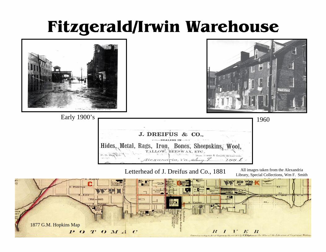
Fitzgerald/Irwin Warehouse
Early 1900’s 1960
Letterhead of J. Dreifus and Co., 1881 All images taken from the Alexandria Library, Special Collections, Wm F. Smith
Collection
1877 G.M. Hopkins Map
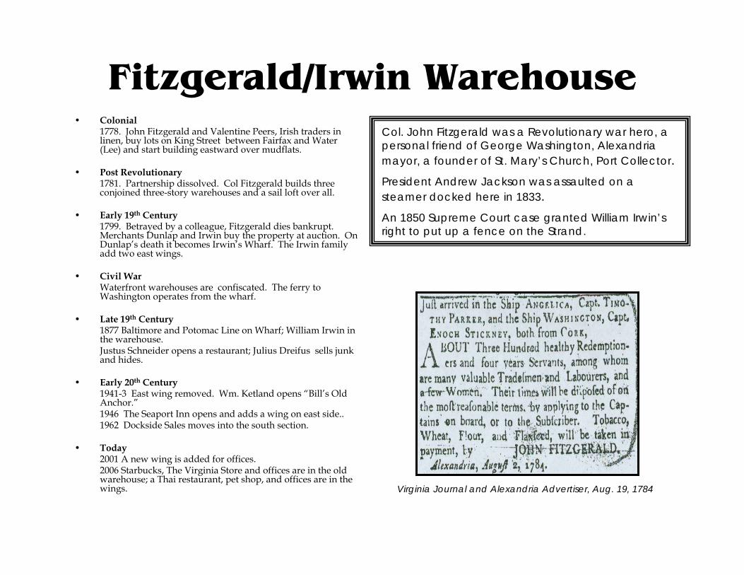
Fitzgerald/Irwin Warehouse• Colonial
1778. John Fitzgerald and Valentine Peers, Irish traders in linen, buy lots on King Street between Fairfax and Water (Lee) and start building eastward over mudflats.
• Post Revolutionary1781. Partnership dissolved. Col Fitzgerald builds three conjoined three-story warehouses and a sail loft over all.
• Early 19th Century1799. Betrayed by a colleague, Fitzgerald dies bankrupt. Merchants Dunlap and Irwin buy the property at auction. On Dunlap’s death it becomes Irwin’s Wharf. The Irwin family add two east wings.
• Civil WarWaterfront warehouses are confiscated. The ferry to Washington operates from the wharf.
• Late 19th Century1877 Baltimore and Potomac Line on Wharf; William Irwin in the warehouse.Justus Schneider opens a restaurant; Julius Dreifus sells junk and hides.
• Early 20th Century1941-3 East wing removed. Wm. Ketland opens “Bill’s Old Anchor.”1946 The Seaport Inn opens and adds a wing on east side..1962 Dockside Sales moves into the south section.
• Today2001 A new wing is added for offices. 2006 Starbucks, The Virginia Store and offices are in the old warehouse; a Thai restaurant, pet shop, and offices are in the wings.
Col. John Fitzgerald was a Revolutionary war hero, a personal friend of George Washington, Alexandria mayor, a founder of St. Mary’s Church, Port Collector. President Andrew Jackson was assaulted on a steamer docked here in 1833.An 1850 Supreme Court case granted William Irwin’s right to put up a fence on the Strand.
Virginia Journal and Alexandria Advertiser, Aug. 19, 1784
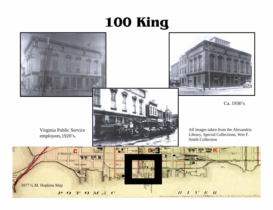
100 King
Virginia Public Service employees,1920’s.
Ca. 1930’s
All images taken from the Alexandria Library, Special Collections, Wm F. Smith Collection
1877 G.M. Hopkins Map
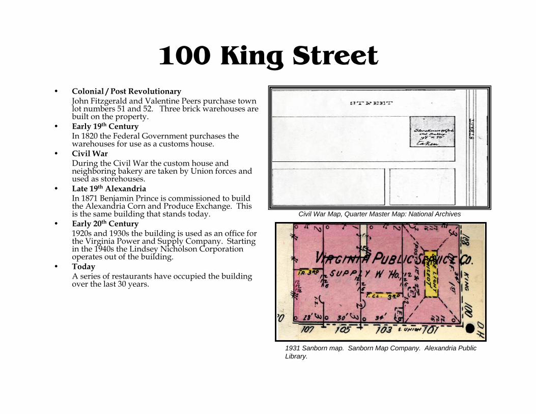
100 King Street• Colonial / Post Revolutionary
John Fitzgerald and Valentine Peers purchase town lot numbers 51 and 52. Three brick warehouses are built on the property.
• Early 19th CenturyIn 1820 the Federal Government purchases the warehouses for use as a customs house.
• Civil WarDuring the Civil War the custom house and neighboring bakery are taken by Union forces and used as storehouses.
• Late 19th AlexandriaIn 1871 Benjamin Prince is commissioned to build the Alexandria Corn and Produce Exchange. This is the same building that stands today.
• Early 20th Century1920s and 1930s the building is used as an office for the Virginia Power and Supply Company. Starting in the 1940s the Lindsey Nicholson Corporation operates out of the building.
• TodayA series of restaurants have occupied the building over the last 30 years.
Civil War Map, Quarter Master Map: National Archives
1931 Sanborn map. Sanborn Map Company. Alexandria Public Library.
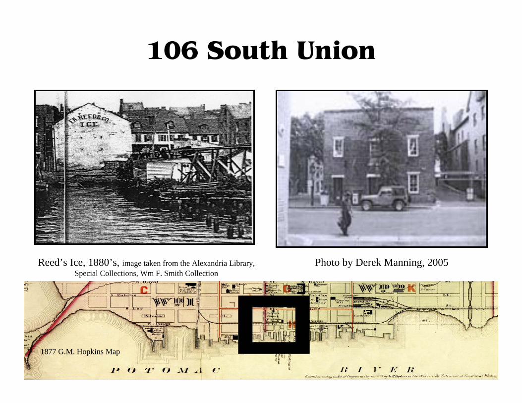
106 South Union
Photo by Derek Manning, 2005Reed’s Ice, 1880’s, image taken from the Alexandria Library, Special Collections, Wm F. Smith Collection
1877 G.M. Hopkins Map

106 S. Union
1877 G. M. Hopkins Insurance Map. Alexandria Public Library.
• Colonial / Post RevolutionPurchased by Fitzgerald and Peers who created the land by banking out the bluffs. Little building development occurs here during this time.
• Early 19th CenturyJonathan Swift purchases the land from Peers and develops buildings. He is first of merchants who will own the land.
• Civil WarLand and buildings continued to be used by many merchants through the Civil War.
• Late 19th CenturyHunt and Roberts rent a building in 1875 and use it as a warehouse to help ease shipping by rail and ship.
• Early 20th Century1915 Roberts closed Cameron Mills to focus on supplying feed to local farmers and stores. The old warehouse is torn down and a new building is constructed in 1916. This is the same building that stands today.
• Late 20th CenturyRoberts continued to provide feed from this location till 1952 when L G Hoge took over for Roberts. In 1962 Dockside Sales buys the building ending over 80 years of grain and feed sales from this location.
• TodayToday this is the location of Olson’s Books and Music which has been there since 1987.
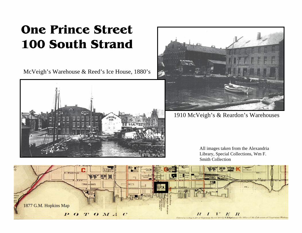
One Prince Street 100 South Strand
1910 McVeigh’s & Reardon’s Warehouses
McVeigh’s Warehouse & Reed’s Ice House, 1880’s
All images taken from the Alexandria Library, Special Collections, Wm F. Smith Collection
1877 G.M. Hopkins Map

One Prince Street• Colonial
1773. Capt. John Harper buys (with properties west to Fairfax) a ¼ acre lot at Water and Prince Sts., with rights to fill in the wetlands.
Post RevolutionaryBy 1785, there is a brick house on the northeast corner of Prince and Union. Jonathan Swift, merchant, uses it as a store and Harper’s son Edward lives there. By century’s end, a large number of merchants are leasing space on Harper’s Wharf.
• Early 19th Century1843. Harper’s daughter Nancy Andrews sells Harper property to William Newton McVeigh, a successful merchant. From now until late in the century, it will be McVeigh’s Wharf. By 1852. McVeigh , Harper and Chamberlain have built a large brick warehouse on Union St. fronting on the river. McVeigh now adds two more. The buildings narrowly escape destruction in the 1854 fire.
• Civil War1864-65. McVeigh loses all properties. In 1868 the south wall of his neglected four-story warehouse at Union and Prince cracks and falls. 1870s, McVeigh regains this property, rebuilds and offers to sell.
• Late 19th CenturyA manufacturer of champagne cider and vinegar occupies the warehouse on Prince and Union. Norfolk and Washington Steamboat Co. acquires the wharf for freight.
• 20th CenturyIn 1938 the warehouse floods. In 1950 the building is demolished. George Robinson & Co. uses the property for a concrete plant and by 1960s, various small stores occupy the Strand.
• TodayIn the mid-1970s, Waterfront Park is built. In 1985, the American Academy of Otolaryngology builds its headquarters.
In 1803 William Harper is one of the “Midnight Judges” involved in the landmark US Supreme Court case, Marbury v. Madison. Was the Marbury on the wharf in 1852 a relative of the principal plaintiff?
In 1863, William Newton McVeigh, a Confederate, and one of Alexandria’s wealthiest, is tried in absentia as a Rebel and all his properties are confiscated the following year.
The last large warehouse on the northeast side of Prince at Union is demolished ca. 1950, after being ravaged by fire and flood.
Virginia Journal and Alexandria Advertiser, October, 1788

0 Prince Street
Above: 1948 advertisement from The Washington Post February 1, 1948.
Left: The Beachcombers Restaurant shortly after they opened. Alexandria Library, Special Collections, John C. Richards Collection
1877 G.M. Hopkins Map

Zero Prince Street• 20th Century
1945. Clarence J. Robinson leases a “parcel…lying east of the Strand” to Edward Wayne, John Bethea and Thomas Hulfish Jr.
1946. The trio build a restaurant, The Beachcombers, over the water on concrete pilings, reachable only by pier. Since they are in District, not Virginia waters, drinks may be sold “by the glass.”
1954. A fire damages the building and the lessees release it toRobinson.
1958. By now the building is surrounded by concrete and Interarmco is using it to store munitions.
1963. Robinson deeds the southeast corner of Prince and Strand to the Potomac Arms Corp, retail outlet for Interarms. John C. Richards owns Potomac Arms. “Full Metal Jacket” will occupy the first floor.
1972. The City Council approves a permit for restaurant boats at the pier behind the store.
1973. A seafood trailer, “The Strand,” opens in the front yard.At the pier, Le Bateau Alexandria is followed by the Dandy.
1999. Potomac Arms is deeded to Stephen and Mark Richards, John Richards’ sons. On the Millennium Eve Nina’s Dandy joins the fleet.
Today2006. The City of Alexandria buys the land and building at 0 Prince.
Beachcomber diners on the roof and porches savor their view of the Prince Street dock and the 7 p.m. loading of the night steamer to Norfolk.
Potomac Arms is entangled in a case of antitank guns used to blast open a Brinks’ vault in Syracuse, N.Y.
The seafood trailer wins the “Onion “ award for bad architecture from the American Institute of Architects.
Post Card. Alexandria Library, Special Collections
Prince to Duke, North Section
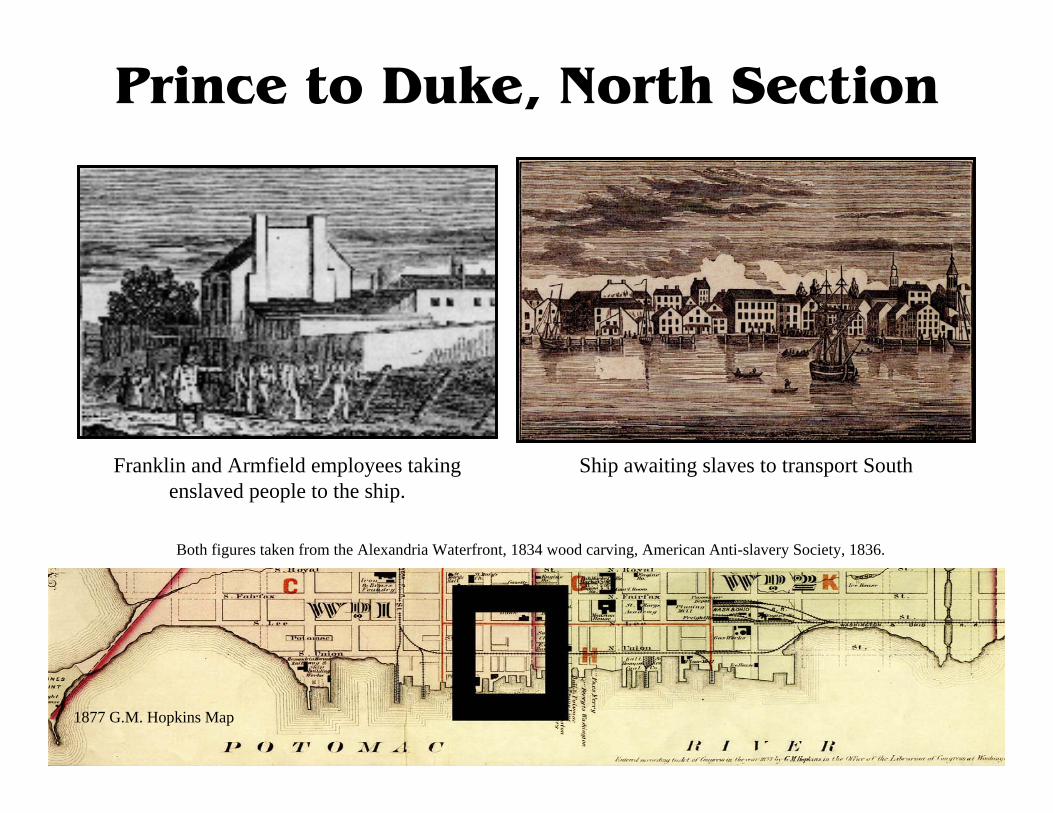
Ship awaiting slaves to transport SouthFranklin and Armfield employees taking enslaved people to the ship.
Both figures taken from the Alexandria Waterfront, 1834 wood carving, American Anti-slavery Society, 1836.
1877 G.M. Hopkins Map

Prince to Duke- North Section• Colonial
1749: Lot 62 bought by Willoughby Newton, later Colonel George Gilpin. Most of block still water.
• Post RevolutionaryMcPherson brothers and Hooe, wholesalers, sold imported goods. West India Rum, fine hats, cordage and candles are among items for sale
• Early 19th CenturyIn the 1820’s Commission merchant John Cripps Vowell : Raisins, wine, almonds and lemons.
• Civil WarUnion Army occupation of Waterfront; Vowellswharf became U.S. Transportation Wharf, and area became warehouses for the Commissary.
• Late 19th CenturySteamship Co. offices, agricultural tools and
supplies warehouses: Virginia Beef Extract Co in 1890’s. The 1897 fire left only 206 Union, Richard Wattles Grain Warehouse.
• Early 20th Century206 is still inhabited by Wattles Corn and Feed Mill; warehouses and Wood Sawing. 203 and 205 stand constructed.
• TodayCommercial and residential uses. Building footprints are consistent with historic maps.
The area has been mainly wholesale groceries and agriculturally related processing and stayed that way into the 20th Century. The entire block shared this theme, but over time these businesses were pushed primarily towards the North section. The mill at 206 S. Union St. is the best surviving example of this agricultural heritage. 203 and 205 S. Strand include parts of 19th century warehouses.
Hooe is one of the Commission Merchants that inhabited the North Section in the Post Revolutionary and Early 19th Century years. Alexandria Gazette, 31 July 1877 p. 3

Prince to Duke, Center Section
West Side of South Union Looking North towards Prince: Street by Street, by:Ethelyn
Cox p. 169.
View of wharves between Duke and Prince St.: Alexandria Library, Special Collections, Wm F. Smith Collection.
1877 G.M. Hopkins Map

Prince to Duke-Center Section• Colonial
Part of lot 69 purchased by Col. George Fairfax in 1749. Resold to Nathaniel Harrison in 1752. Area East of Union still under water.
• Post Revolutionary1775: Lot developed by Richard Arell. 1787: Arell’sdaughter Christiana and her husband William Hunter receive land. The Hunters and Abram Hewes build out the land and wharf.
• Early 19th CenturyAbram Hewes leased the center section of the block in 1792, operates auction business and wholesales plaster, brandy, Antigua rum. Sells from wharf.
• Civil WarDuring the Union occupation, this area was used as a storage area for the Commissary.
• Late 19th Century1877: Barrel Manufacturer, Washington Blythe.1885: Hewes and Aitcheson’s Coal Yard dynasty began.
• Early 20th CenturyD.W. Aitchesons Coal and Wood Yard. Aitchesonrebuilds in 1902 after the 1897 fire.
• Late 20th Century D.W. Aitcheson Coal and fuel stayed through the late 1970’s. As of the 1980’s it has been the parking and strip mall we see today.
Barrel makers and commission wholesale merchants were the earliest businesses. D.W. Aitcheson started around the 1880’s, with his coal yard. Coal and Aitcheson became a fixture on the block. Eventually he added lumber to his inventory. Coal and fuel stayed as the focus of the Center section until the 1970’s.
Aitcheson was a force from the late 19th Century to the 1970’s providing Alexandria with coal and fuel. Richmonds Directory of Alexandria, 1900, p. 70

Prince to Duke, South Section
Civil War view from Pioneer Mill Looking North: Alexandria Library, Special Collections, Wm F. Smith Collection
1877 G.M. Hopkins Map

Prince to Duke-South Section• Colonial
Part of lot 69 purchased by Col. George Fairfax in 1749. Resold to Nathaniel Harrison in 1752. Half of block East of South Union St. still water.
• Post Revolutionary1775: Lot developed by Richard Arell. 1787: Arell’sdaughter Christiana and her husband William Hunter receive land. The Hunters and Abram Hewes build out land/ wharf.
• Early 19th CenturyCapt. George Slacum, Merchant. Warehouse burned in 1810 fire: traded with the West Indies.
• Civil WarUnion Army Occupation: Union Hay and Grain storage. Barracks and Storehouse East of Strand.
• Late 19th Century1885:Sumac Mill closed. Sumac Warehouses and Iron Foundry. Aitcheson Planning Mill. W. S. Moore’s Foundry. O.D. Boat Club Built.
• Early 20th CenturyBryant Fertilizer rebuilt after 1897 fire. 1902 Acid house to Sumac Mill. O. D. Boat Club rebuilt
• Late 20th CenturyRobinson arsenal, packing and crating. Marine Equipment in footprint of acid house, possible surviving walls.
This section of the block tends to share a pattern with the south side of Duke St. The area tends to be owned by one major person at a time. In the early years, Rosenthal’s sumac gave an industrial feel. Late 19th
Century Bryant’s Fertilizer business continued until the1930’s and 40’s. Business was back in the 50’s and 60’s with Robinson arsenal and packing and crating warehouse for guns and paper products. Today the Art League is in the property.
Sumac harvested in Virginia was ground and used by tanners to help cure and dye hides. http://www.botanical.com/botanical//mgmh/s/sumach97.html
Duke to Wolfe, Pt. Lumley
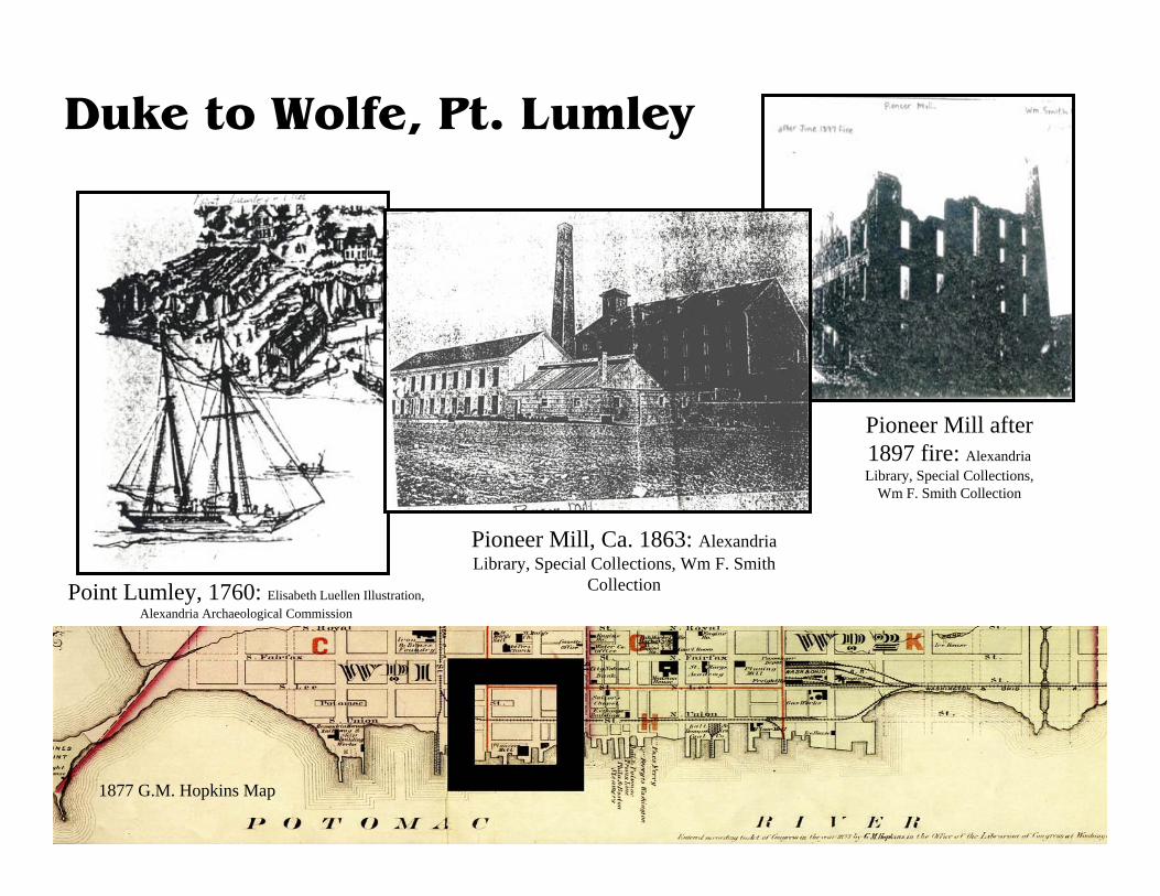
Pioneer Mill after 1897 fire: Alexandria Library, Special Collections,
Wm F. Smith Collection
Pioneer Mill, Ca. 1863: Alexandria Library, Special Collections, Wm F. Smith
CollectionPoint Lumley, 1760: Elisabeth Luellen Illustration, Alexandria Archaeological Commission
1877 G.M. Hopkins Map
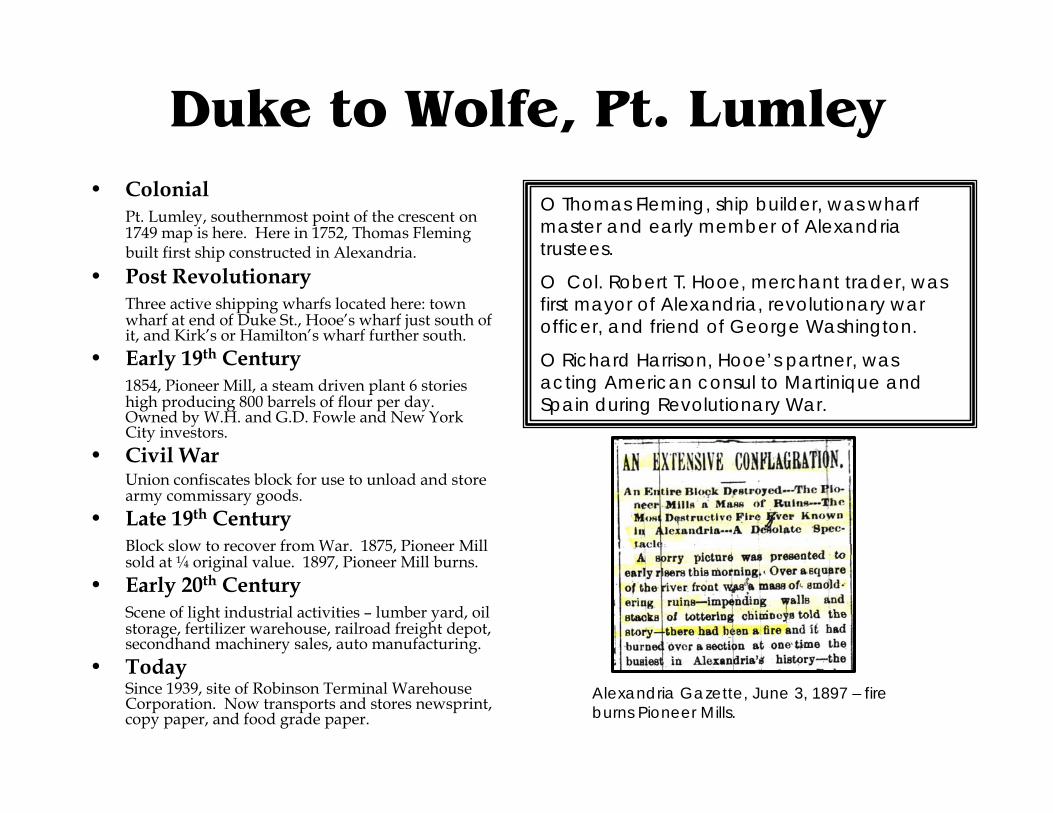
Duke to Wolfe, Pt. Lumley• Colonial
Pt. Lumley, southernmost point of the crescent on 1749 map is here. Here in 1752, Thomas Fleming built first ship constructed in Alexandria.
• Post RevolutionaryThree active shipping wharfs located here: town wharf at end of Duke St., Hooe’s wharf just south of it, and Kirk’s or Hamilton’s wharf further south.
• Early 19th Century1854, Pioneer Mill, a steam driven plant 6 stories high producing 800 barrels of flour per day. Owned by W.H. and G.D. Fowle and New York City investors.
• Civil WarUnion confiscates block for use to unload and store army commissary goods.
• Late 19th CenturyBlock slow to recover from War. 1875, Pioneer Mill sold at ¼ original value. 1897, Pioneer Mill burns.
• Early 20th CenturyScene of light industrial activities – lumber yard, oil storage, fertilizer warehouse, railroad freight depot, secondhand machinery sales, auto manufacturing.
• TodaySince 1939, site of Robinson Terminal Warehouse Corporation. Now transports and stores newsprint, copy paper, and food grade paper.
O Thomas Fleming, ship builder, was wharf master and early member of Alexandria trustees.
O Col. Robert T. Hooe, merchant trader, was first mayor of Alexandria, revolutionary war officer, and friend of George Washington.
O Richard Harrison, Hooe’s partner, was acting American consul to Martinique and Spain during Revolutionary War.
Alexandria Gazette, June 3, 1897 – fire burns Pioneer Mills.

100 Prince
1960s: Street by Street, Ethelyn Cox p. 118 2006: Alexandria Archaeology Collection
1877 G.M. Hopkins Map

100 Prince• Colonial
1749: Lot 62 bought by Willoughby Newton, later Colonel George Gilpin. Eastern part of Prince St. still in water.
• Post Revolutionary1794:Col Gilpin sold parcel to James Lawreson and Benjamin Shreve. They built a 3 story brick warehouse. Goods imported sold include: Aniseed cordial, Souchong tea, Jamaica rum and sacks of licorice root and sago.
• Early 19th CenturyOwned by merchant William Fowle, partner of James Lawreson, the warehouse was damaged in the 1827 fire. Imports in the warehouse: currants, Russian duck, Boston molasses, corks.
• Civil War Union Army occupied much of this area with Commissary storage, but this buildings use unknown.
• Late 19th CenturyContinued as a warehouse like 101 Prince St.; wholesale grocery.
• Early 20th CenturyAlternated between vacancy and warehouse for wholesale groceries, hides and junk.
• Today100 Prince remained a warehouse until 1966 when it was renovated and converted into a residence. It has enjoyed a series of residents and a more upscale use.
Shreve and Lawreson built the warehouse, and sold exotic goods: ravens duck, black satin, English cheese and Holland gin. Fowleand Lawreson continued to sell cognac, almonds, Nankin crapes and Maderia wines. The warehouse after the Civil War stayed in groceries but soon moved to housing hides and junk until it was changed into housing.
Shreve and Lawreson Ad, Alexandria Advertiser, Vol. 3, p. 38 1786/05/04
125 South Union Street Harper Warehouse
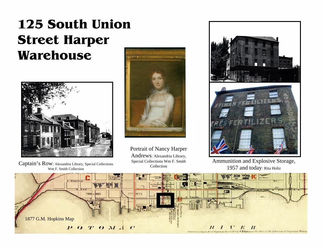
Captain’s Row: Alexandria Library, Special Collections Wm F. Smith Collection
Ammunition and Explosive Storage, 1957 and today: Rita Holtz
1877 G.M. Hopkins Map
Portrait of Nancy Harper Andrews: Alexandria Library, Special Collections Wm F. Smith
Collection

125 South Union Street• Colonial
1773. Capt. John Harper, merchant and mariner, moves here fromPhiladelphia and purchases lots running from Fairfax Street down Prince to Water (Lee) and into the Potomac. 1775 Harper’s is already ranked fourth among Alexandria’s 20 major mercantile firms.During the next decade, he “banks out” his land, and constructs his wharf and warehouse. He is elected a member of the town’s first council in 1779..
• Post Revolutionary1784. Harper has a store on the northwest corner of Prince andUnion and is building houses along today’s “Captain’s Row.”By mid-1790s , the corner warehouse has passed to Mary Harper Vowell and on her death in 1805, to her husband, Thomas Vowell.1804 Capt. Harper dies.
• 19th CenturyBy mid-century, the warehouse is owned by Isaac Buckingham, a tobacconist, and, after the Civil War, by his daughter, Mary Field. Her husband, John A. Field, is also a tobacconist with a store at 71 King St. In 1865, a John A. Field is selling military uniforms and gentlemen’s clothing from King Street. From 1885-89 a fertilizer company occupies the warehouse.
• Late 19th & Early 20th Century1890 Rosa Dreifus, wife of Julius Dreifus, buys Field’s property. It will stay in the family through today. He and his brothers, and later his sons. use the warehouse for storage and sale of junk, rags and hides, continuing after Julius’ death in 1910.
• Late 20th Century1950 Crowder’s moving company moves in.After standing vacant from 1953 to 1956, the building is leased to George E. Viereck and Co. for farm equipment.Interarmco follows the farm business, adding to that company’s substantial presence on Union St. The maps show “Explosive Storage” here.1965 Vickie Lee Warren, great niece of Stella Dreifus inherits the warehouse. 1971 The Picture Place moves in.
• TodayIn 1978, The Christmas Attic follows the Picture Place.
1799 A “strike” on the waterfront. Harper’s “journeymen” threaten to stop work unless paid every Saturday evening.
1810 A devastating fire starts on Royal Street and sweeps down Prince, severely damaging houses Harper built, but sparing his warehouse.
“Writing on the Walls” The fertilizer signs may date back to 1885 when insurance papers show a Fertilizer Warehouse here.
Dreifus’ signs - Julius Dreifus junk yard from 1890 to 1940.
“Agricultural Implements” - George Viereck & Co 1956.
This may be the first mention of Harper’s warehouse. It appeared in the Virginia Journal and Alexandria Advertiser in June 1784.