waters avenue revitalization
DESCRIPTION
This project explored potential revitalization strategies for the Waters Avenue Corridor in Savannah, Georgia. Conducting historical research and analyzing current conditions played an important role in developing future plans for the neighborhood. Prepared for HIPR 425 - Downtown Revitalization with Professor Jong Hyun Lim.TRANSCRIPT
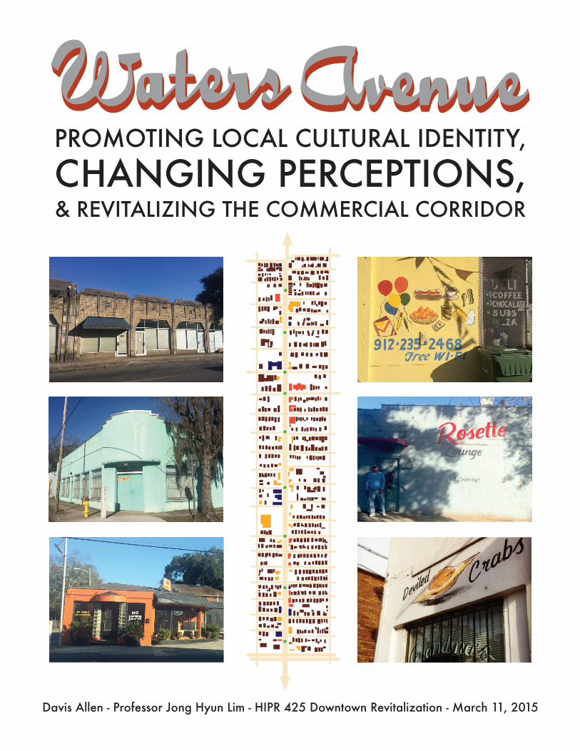
PROMOTING LOCAL CULTURAL IDENTITY,CHANGING PERCEPTIONS,& REVITALIZING THE COMMERCIAL CORRIDOR
Davis Allen - Professor Jong Hyun Lim - HIPR 425 Downtown Revitalization - March 11, 2015

TABLE OF CONTENTS !
PROJECT INTRODUCTION
HISTORICAL CONTEXT
OVERVIEW
EARLY DEVELOPMENT
TRANSPORTATION BRINGS COMMERCIALIZATION
WATERS’ ECONOMIC HEYDAY
A NEIGHBORHOOD IN ECONOMIC DECLINE
CURRENT NEIGHBORHOOD SITUATION
OVERVIEW
ANALYZING SOCIAL AND ECONOMIC FACTORS
SITE OBSERVATIONS
CRIME AND PERCEPTIONS
PAST REVITALIZATION ATTEMPTS
FUTURE REVITALIZATION STRATEGIES
OVERVIEW
SOLUTION 1 - ENHANCEMENT OF PUBLIC COMMUNICATION
SOLUTION 2 - SPECIAL EVENTS
SOLUTION 3 - COMMUNITY MARKET
SOLUTION 4 - URBAN DESIGN IMPROVEMENTS
SOLUTION 5 - INCREASING FUNDING
EXPECTED RESULTS
BIBLIOGRAPHY
1-2
CHAPTER 1
3
4-6
7-9
10-13
13-16
CHAPTER 2
17
17-18
19-22
22-23
24-25
CHAPTER 3
26
26-27
27-29
30-31
31-33
33-34
34-35
36-37

PROJECT INTRODUCTION
Visitors to Savannah are drawn to the city’s idyllic buildings, squares, and landscaping in
the downtown historic district. Because of the tourism industry, the city has invested heavily into
improvements to the downtown area where visitors and tourist attractions are located. While
further improvements to downtown could still be made, the areas for the greatest possible
improvement in terms of economics and quality of life lie outside of the National Register
Historic District. The Waters Avenue Corridor, located to the east of downtown Savannah, has
developed as a secondary Main Street within the context of Savannah, and has been on an
economic decline for 60 years. The neighborhood is in need of revitalization.
A simple drive down Waters Avenue can give a lot of insight into the district. There is
evidence of a previously existing commercial district that is in distress - once thriving businesses
have windows that are boarded up, and empty lots that previously contained businesses are now
vacant or used as parking lots. The area is not completely abandoned, however, and still contains
has a handful of locally owned businesses, community centers, and churches that contribute to
the life of the street. Several changes, which will be discussed in this report, could be made to the
area that would allow the area to grow to the commercial center that it once was.
A comprehensive plan for revitalization would be very beneficial to Waters Avenue.
Although it lies outside what is typically considered the downtown center of Savannah, it has
many qualities that classify it as a traditional downtown. Re-investing in the area and re-branding
it as a hub for harboring the growth of local businesses could be a way to alleviate the problems
that are arising in Savannah’s downtown historic district. The rise of tourism and the increase of
upscale national chain stores in downtown Savannah has begun to increase rents and force local
1

businesses to close their doors or move to more affordable locations. Ben Carter’s recent
developments along Broughton Street demonstrate that these changes are taking place at a
surprisingly rapid rate. There is going to be a need for lower rents on commercial spaces in
Savannah so that local businesses can continue to thrive. If Waters Avenue is improved and
revitalized, the district will have the potential to attract local businesses that cannot afford the
rents of downtown Savannah. Revitalizing the district would have the potential for economic
improvement to Savannah and to business owners, as well has potentially improving the quality
of life of residents in the neighborhood.
2

CHAPTER 1 - HISTORICAL CONTEXT
OVERVIEW
Although Waters Avenue does not share the same timeframe of history as
Savannah’s downtown Historic District, the street is still historically significant. The
Waters Avenue corridor is a cultural landscape that has been shaped by the historical
development of the city of Savannah. Early settlement patterns, transportation, the rise
and fall of commercialism have all left their mark in shaping the way the street appears
today.
Waters Avenue runs North to South on the east side of downtown Savannah. The
street is bound on the north by Wheaton and continues south for several miles, all the
way to the suburban south-side of Savannah. The street lies approximately halfway in
between downtown Savannah and the Truman Parkway, which is a controlled access
highway that runs parallel to Waters Avenue. For the purposes of downtown
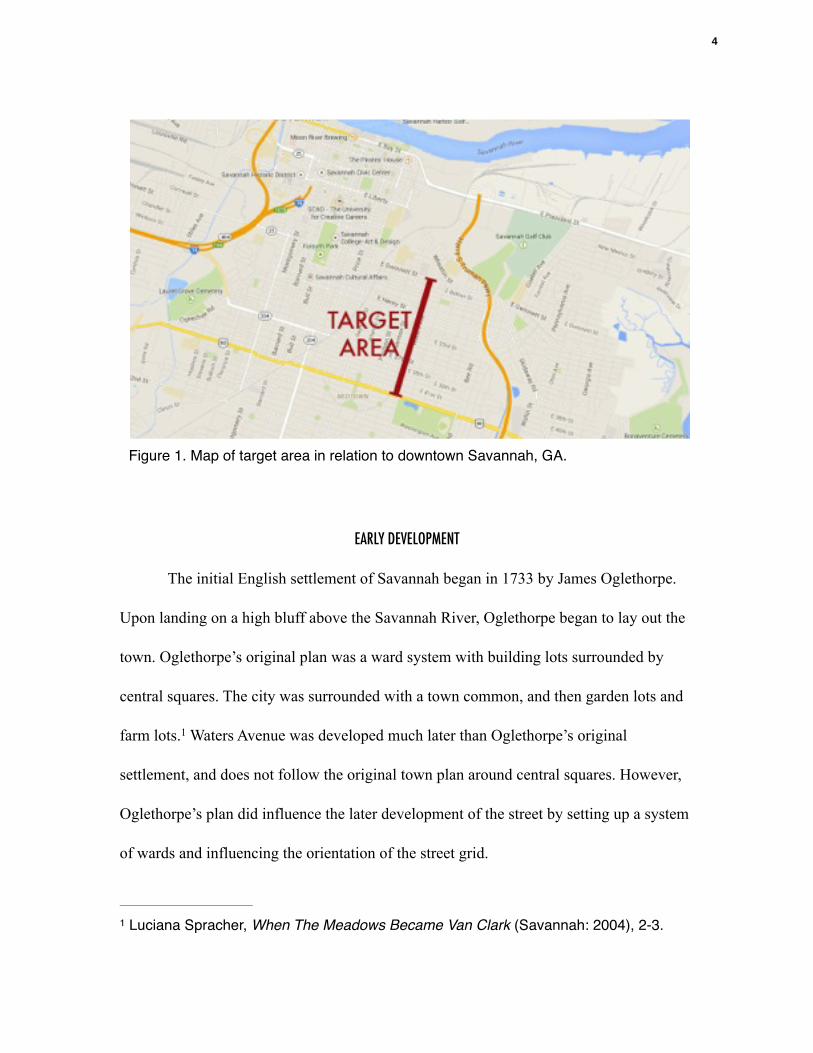
revitalization, the focus area of this street will be a 1.1 mile segment between Gwinnett
Street and Victory Drive. (see figure 1) This segment of Waters Avenue is, and has, for
the most part of history, been a mixed-use community. There is both residential and
commercial space that occupies the street. The streets running east to west which
intersect Waters are residential streets. Since people live close to the commercial spaces
and the area is walkable, it does follow the traditional pattern of “Main Street.” However,
the high amount of vacant commercial spaces makes the neighborhood currently lack the
sense of a Main Street.
3
!EARLY DEVELOPMENT
The initial English settlement of Savannah began in 1733 by James Oglethorpe.
Upon landing on a high bluff above the Savannah River, Oglethorpe began to lay out the
town. Oglethorpe’s original plan was a ward system with building lots surrounded by
central squares. The city was surrounded with a town common, and then garden lots and
farm lots. Waters Avenue was developed much later than Oglethorpe’s original 1
settlement, and does not follow the original town plan around central squares. However,
Oglethorpe’s plan did influence the later development of the street by setting up a system
of wards and influencing the orientation of the street grid.
Luciana Spracher, When The Meadows Became Van Clark (Savannah: 2004), 2-3.1
Figure 1. Map of target area in relation to downtown Savannah, GA.
4

In Savannah’s early days, the Waters Avenue corridor was swampy, sparsely-
populated farm land. A map from 1812 labels one of the landholders in this area as
“Waters”, which is likely where the name of the street originated. By 1854, the city of 2
Savannah pushed its boundary eastwards to extend to Waters Avenue, and by 1868, a road
labeled “Waters Road” had appeared. At this time, the area was still very sparsely 3
populated because of the swampy landscape. A canal system draining the swampy eastern
portion of Savannah was implemented in 1876, which allowed much of the land east of
East Broad Street to be developed. 4
As the city of Savannah grew, development along Waters Avenue initially began
at the north and gradually moved towards the south.. Imagery from Sanborn Insurance
Company Maps show that in 1898, the street was mostly comprised of wood frame
dwellings. (see figure 2) The highest concentration of these houses was at the north end 5
of the street near its intersection with Wheaton Street. The 1898 map shows development
on Waters reaching southwards to Anderson Street. The number of buildings that are on
Waters Avenue dissipate towards the south, with a majority of residential development
occurring on the east-west streets. 1916 Sanborn maps show a much higher concentration
of buildings on Waters Avenue. A mixture of residential, commercial, and light industrial
Thomas Gable, Jr., A History of the Government of Savannah, Georgia, from 1790 to 2
1901, (Savannah: Savannah City Council, 1900), 29; “City of Savannah” (1812), M5 1018 Waring Map Collection, Vol. 2, Plate 12, GHS.
Luciana Spracher, When The Meadows Became Van Clark (Savannah: 2004), 6-7.3
Ibid.4
“Savannah 1898.” Sanborn Map.5
5

uses are represented, and development by this time had reached southwards to Victory.
Overlays glued to the maps show additional commercial development which increased
during the following three decades. (see figure 3)
Figure 2: 1898 Sanborn maps, showing a higher concentration of buildings on the North end
Figure 3: 1916 Sanborn maps, showing imagery of Waters avenue between 37th and Victory, with a higher concentration of buildings as well as overlays of commercial spaces added after 1916.
6

TRANSPORTATION BRINGS COMMERCIALIZATION
The development of the Waters Avenue corridor at the turn of the 20th century
was due to the rise of the electric streetcar as transportation. The streetcar gave life to
some of the first suburbs in Savannah, as people living in town were able to move further
away from the city center. Many of these people were seeking the space that the outskirts
of the city provided, but still had the convenience of streetcar travel to quickly reach in-
town services. According to the Savannah Morning News in 1892:
The extended limits of the city south, east, and west are building up at a
remarkable pace and the places known only a short time once as the suburban
commons are becoming young towns. The extension of the street railways is what
has brought about these gratifying results. 6
Real estate companies during the turn of the century used the streetcars as a way to
develop the land and turn a profit. The company typically put in the tracks and divided
the land on the outskirts of town, which drew residences and businesses out along the
streetcar lines. The same appears to be true for Waters Avenue. A schedule of the Electric 7
Railway Company, published in the 1895 city directory, states a specific streetcar route
that left the city market in downtown Savannah and went south on Waters Avenue
between Anderson Street and present day Victory Drive before connecting with the Isle of
Savannah Morning News, September 3, 1892.6
Mary Beth Alonzo. Streetcars of Chatham County: Photographs from the Collection of 7
the Georgia Historical Society. (Charleston, S.C.: Arcadia, 1999).
7

Hope Railroad. A later photograph from 1931 shows the intersection of Waters Avenue 8
and Bolton Street, with streetcar tracks running down Bolton, but not on this portion of
Waters. (see figure 4) Several small businesses are located at the intersection, although
automobiles were also a major factor of urban transportation by this time.
The personal automobile transformed the way American cities grew and
developed. Automobiles provided freedom from laid tracks and timed schedules, to those
who could afford it. Savannah embraced this new form of transportation relatively early
in its history. A postcard from 1911 shows that a portion of Waters Avenue, slightly south
“Savannah City Directory, 1891,” (Savannah: The Morning News Print, 1895) 57.8
Figure 4: Intersection of Waters Avenue and Bolton Street, with streetcar tracks on Bolton. Augusta K. Corday, photographer. “Waters Avenue at Bolton Street” Photograph. Savannah. 1931. From Georgia Historical Society: Foltz Photographic Studio, 1899-1960
8

of the target area, was used as part of the racecourse for the Vanderbilt Cup. (see figure 9
5) This race was considered to be “of international interest and importance” at the time,
and demonstrates that Savannah embraced the new technology. The rise of Savannah’s
Automobile suburbs of Ardsley Park and Chatham Crescent to the target area’s
immediate south reinforce this idea, and are the results of another wave of
suburbanization. Waters Avenue, once a suburb on the outskirts of town, now acted as an
automobile thoroughfare between downtown and the new suburbs. During this time
period in Waters Avenue’s history, rapid expansion of businesses occurred.
“Waters Road - Automobile Race Course.” Photograph. Savannah. 1910. http://9
www.vanderbiltcupraces.com/blog/article/then_now_1911_vanderbilt_cup_race_course-_waters_street_savannah
Figure 5: Waters Avenue as part of the racecourse for the Vanderbilt Cup
9

WATERS’ ECONOMIC HEYDAY
The commercialization of the early 20th century gave Waters Avenue a unique
character as a walkable traditional “main street” located slightly outside of the downtown
area. Figure 6 shows four historic photographs businesses located within the target area.
These photos were taken between 1935 and 1950, during Waters Avenue’s commercial
heyday. Two particularly compelling photographs show an automobile service station and
an early example (1946) of a suburban-style shopping center. These businesses
demonstrate that Waters Avenue embraced early automobile travel and benefitted
economically from it.
Figure 6: Historical photographs taken between 1935 and 1950 of businesses in the target area. Images were collected from the Georgia Historical Society’s Digital Image Catalog
10

It is also interesting to point out that the makeup of the neighborhood before its
economic downturn during the second half of the 20th century. The target area was part
of a neighborhood that was economically and socially mixed. There was a mixture of
African American and white residents, a mix of home owners and renters, and a mix of
working class and professionals. An archaeological study showed that people living 10
near Waters avenue in the early 20th century were “fully integrated into the commercial
economy of the City of Savannah, and relied almost entirely on goods purchased from
stores.” Many of the items that these residents owned, which were found on the 11
archaeological dig, were likely purchased at retail stores on Waters Avenue.
Archaeological evidence from commercial locations shows signs that the businesses on
Waters avenue were often cultural gathering spots for the neighborhood. Discarded
animal bones and Coca-Cola bottles discovered in front of retail locations show that
people were likely gathering and socializing in addition to solely buying goods.
Businesses acting as a community gathering place were part of Waters Avenue’s
intangible cultural heritage. This aspect has carried over into the present day, with the few
shops that remain open. Just like during the early 20th century, people still gather in front
of businesses to socialize, eat and drink.
!
Working Class Savannah: Studying the Waters Avenue Neighborhood through 10
Historical Archaeology. Atlanta, Georgia: TRC, 2006.
Ibid.11
11

With an increase in transportation, an increase of commercialization along Waters
Avenue occurred during the first half of the 20th century. A collection of data from City
Directories shows how the number of active businesses in the target area have risen and
fallen during the last century. (see figure 7)
The data collected tells a great deal about the history of commercial activity along Waters
Avenue. The number of businesses prior to the 1920s, the timeframe associated with the
streetcars was relatively low. However, once the automobile became popular, the
commercialization along the Waters Avenue corridor boomed. Although growth was
slightly slowed, the area even continued to gain businesses during the depression years
Figure 7: Rise and fall of commercial activity within the target area
12

between 1930 and 1940. The postwar era also showed a period of booming business, and
the number of businesses peaks in 1950 with a total of 91 businesses. After 1950 and
continuing to the present day, there has been a steady decline in the number of active
businesses within the target area.
!A NEIGHBORHOOD IN ECONOMIC DECLINE
Suburbanization was not new to cities during the 1950s, but at that time, the scale
was increased to sprawl. This change in cities which had a detrimental effect on
commercial areas closer to the city, and figure 6 shows that effect in a clear, graphical
form. The Civil Rights movement also created racial tension across the country. In
Savannah, this led to a “mass movement of upper class white residents from the
downtown suburbs towards the south side and island suburbs, creating a segregated
community that for the most part had been a very integrated area.” As wealthier citizens 12
moved out, the businesses followed. Small grocery stores which once lined Waters
Avenue were phased out by large-scale supermarkets and shopping centers. By the 1980s,
most of the people left behind on Waters avenue were “the elderly who did not want to
leave and those who couldn’t afford to leave.” 13
The persistent economic decline on Waters Avenue during the latter half of the
20th century had a huge impact on the community today. The abandonment and
Luciana Spracher, When The Meadows Became Van Clark (Savannah: 2004), 176.12
Ibid. 17713
13

dilapidation of buildings following the
economic downturn was cause for some residents to move away from the area. One
resident was interviewed, and stated that “a lot of the people moved away, because of the
buildings, they were run down.” Historic photographs show the progression of a 14
property within the target area which echoes the simultaneous downturn of the Waters
Avenue corridor. (Figures 8, 9, and 10) Figure 8, an undated photograph which was likely
from the 1940s, shows the property during Waters Avenue’s commercial prosperity. 15
There are cars and bicycles on the street as well as signs of economic activity within the
store. Figure 9, an image from Google Maps street view, shows that by 2007 the property
was a vacant storefront which resulted from the population and economic shift over the
Gladys Turner, Benjamin Van Clark Neighborhood Oral History Collection Project. #19.14
Figure 8: undated photograph, likely from the 1940s, which shows a building at the intersection of Waters Avenue and 31st street.!!Dixie Studio, photographer. Konter’s Market. Photograph. Savannah, c1940. Savannah. From Georgia Archives: Vanishing Georgia. web.
Figure 9: By 2007 the property was a vacant storefront which resulted from the population and economic shift over the previous 50 years.!!Savannah, GA. Google Maps Street View. 2007. Google. Web.
14

previous 50 years. Figure 10 shows a more recent photograph of the property which has
been demolished to create a vacant lot on Waters Avenue.
During the last 30 years, some attempts have been made to alleviate the symptoms
of the economic downtown and revitalize the district. During the 1980s, the city zoned
much of the target area to prohibit alcohol sales. The area had seen a rise in crime and the
city attributed the crime to people loitering and drinking on the street. That zoning was 16
overturned during the following decade, however as recently as 2008, the city has
attempted to change the zoning of the area to prohibit alcohol sales for the same reason. 17
Figure 10: The property has been demolished and is currently a vacant lot.!Savannah, GA. Google Maps Street View. 2014. Google. Web.
Pureterrar Witcher. “Waters Avenue Redevelopment Means Curbing Alcohol 16
Proliferation,” The Business Report & Journal, August 25, 2008.
Ibid.17
15

Other efforts by the city to revitalize the area have included business loan programs, tax
credits, infrastructure improvements provided by a Special Purpose Local Option Sales
Tax, and investment in business development through the Savannah Entrepreneurial
Center. Although some attempts have been made to revitalize the area, most have not had
a substantial impact on the area.
Although money is being put in to the district for improvements, the target area is
still in a severe economic slump. It seems that projects closer to the city center have taken
precedence over Waters Avenue in terms of funding and attention. Waters Avenue has
been formed and shaped by its unique history. The steps that the city and the community
take during the present and the near future could determine if that unique history is
preserved through restoring economic activity back to the district.
!!!,
!!!
16

CHAPTER 2 - CURRENT NEIGHBORHOOD SITUATION
OVERVIEW
Although Waters Avenue was once a bustling business corridor, a view of the
street today shows signs of a historic commercial district in distress. There are some
indications of the street’s heyday, but the signs of the neighborhood’s gradual economic
downtown of the past 50 years have grown to dominate the contemporary landscape
along Waters Avenue. Hopefully, future revitalization efforts will be able to alleviate
many of these problems.
!ANALYZING SOCIAL AND ECONOMIC FACTORS
Maps and statistical data provide insight on many social and economic factors in
the area. The target area of Waters Avenue has the reputation of being an impoverished,
but this is not necessarily the case. A map of the median household income shows that the
target area certainly does not have as much wealth as Ardsley Park or downtown. (See
figure 11) However, there are two large portions of the target area that have household
incomes well above the city average of $33,167. The west side of Waters between Victory
and 38th has a median income of $48,148, and the east side of Waters between 34th and
38th has a median income of $46,050. The northern parts of the target area have
significantly lower household incomes, with the lowest being $15,679 on the east side of
Waters between Bolton Street and Henry Street. Most of the home values in the
surrounding neighborhood are below the city average of $140,600. The only exception
17

being the western portion of Waters Avenue between Victory and 38th, which has a
slightly larger home value of $148,596. 1
Maps with racial demographics show that the neighborhood surrounding Waters
Avenue is currently a majority African American neighborhood. (See figure 12) Over
90% of the residents on the blocks immediately bound by waters are African American.
The same map shows a clear racial divide within the neighborhood. Victory drive, the
southern boundary of the target area, separates the primarily African American
neighborhood on the north from the primarily white neighborhood on the south.
!
"Savannah, Georgia." City Data. Accessed February 14, 2015. http://www.city-1
data.com/city/Savannah-Georgia.html.
Figure 11. City-data map showing median household income, with purple demonstrating higher income. Target area is outlined in Green.
Figure 12. City-data map showing African American populations, with purple demonstrating higher percentages of African American residents. Target area is outlined in Green.
18
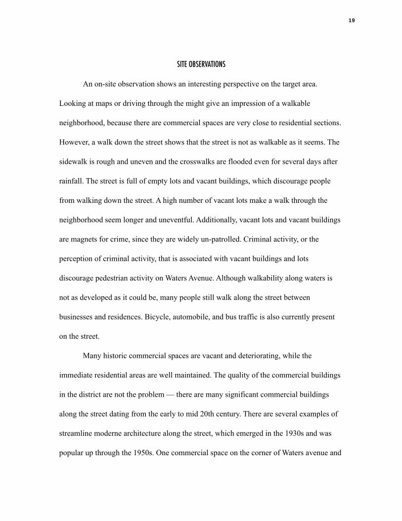
SITE OBSERVATIONS
An on-site observation shows an interesting perspective on the target area.
Looking at maps or driving through the might give an impression of a walkable
neighborhood, because there are commercial spaces are very close to residential sections.
However, a walk down the street shows that the street is not as walkable as it seems. The
sidewalk is rough and uneven and the crosswalks are flooded even for several days after
rainfall. The street is full of empty lots and vacant buildings, which discourage people
from walking down the street. A high number of vacant lots make a walk through the
neighborhood seem longer and uneventful. Additionally, vacant lots and vacant buildings
are magnets for crime, since they are widely un-patrolled. Criminal activity, or the
perception of criminal activity, that is associated with vacant buildings and lots
discourage pedestrian activity on Waters Avenue. Although walkability along waters is
not as developed as it could be, many people still walk along the street between
businesses and residences. Bicycle, automobile, and bus traffic is also currently present
on the street.
Many historic commercial spaces are vacant and deteriorating, while the
immediate residential areas are well maintained. The quality of the commercial buildings
in the district are not the problem — there are many significant commercial buildings
along the street dating from the early to mid 20th century. There are several examples of
streamline moderne architecture along the street, which emerged in the 1930s and was
popular up through the 1950s. One commercial space on the corner of Waters avenue and
19

40th street is a streamline moderne building which is vacant, but still standing. (See
figure 13) The corner of the building is a large curve that contains the entrance, and the
exterior is a smooth stucco finish with light blue tile accents. Another streamline moderne
building, currently being used as a restaurant, was part of an early 1940s shopping center.
(See figure 14 & 15) Half of the original shopping center has been demolished. A
building at the corner of Waters and 42nd has an elegant art deco facade. (See figure 16)
Contemporary curtain walls show that the building was likely recently renovated, and
signs indicate that a law office is located within the building. However, there are not
signs of activity in or around the building, and the facade is beginning to show signs of
Figure 13. Streamline moderne building located at the corner of Waters Avenue and 40th Street.
Figure 14. Streamline moderne shopping center. The left portion of the building is a restaurant, and the right is vacant.
Figure 15. Foltz Photography Studio, photographer. “1908 Waters Avenue” 1946, photograph. from: Georgia Historical Society, Digital Image Catalog
Figure 16. Streamline moderne shopping center. The left portion of the building is a restaurant, and the right is vacant.
20

minor deterioration. In fact, there are many commercial spaces along Waters Avenue that
have business signage but are difficult to determine whether or not a business is actively
located within. This conflicting information can leave a pedestrians and potential
customers with a sense of confusion.
Although many of the commercial buildings are not actively being used, there are
still businesses and neighborhood gathering spaces along Waters Avenue. There are a
large number of religious institutions, including several churches and a community center
for the Baha’i faith. Several local restaurants, small bars, and lounges are operating in the
area as well. A barber school and multiple barber shops are active businesses along the
street as well. During a site visit, a yard sale was taking place on a vacant lot that once
contained a commercial building. Presently, the most active businesses seem to be those
associated with car culture. Businesses with the most amount of human activity during
the site visit included gas stations, car washes, and convenience stores. Unfortunately,
convenience stores might be where the most impoverished nearby residents have access
to foods. A meat and seafood market is present along Waters Avenue, but there are no
grocery or produce stores for residents to buy affordable, nutrient-rich foods.
Waters Avenue still has a unique identity to those who presently live or work in
the area. Restaurants, Lounges, and religious cultural centers all serve as places of
gathering and socialization. Several buildings in the area have vibrant paint colors, which
provide a very appealing contrast to the abandoned commercial spaces or vacant lots.
Many businesses have a tradition of hand painted signs. Bright colors are also present in
21

the paint colors of these signs, as well as stylized versions of the commercial products
sold within stores. Hand-painted script fonts which are seen on these signs is seen all
along Waters avenue and other parts of the city of Savannah. It could be argued that these
images and text, hand painted by business owners and community members, are a
culturally significant vernacular art form. (See figures 17 & 18)
!CRIME AND PERCEPTIONS
To many Savannahians, Waters Avenue has a reputation for being a high crime
area. In the recent past, this perception of criminal activity has certainly been a barrier to
redeveloping the area. Just like in most urban neighborhoods, crime is certainly present
along Waters Avenue. However, crime statistics how that the impression of Waters
Avenue having an unusually high concentration of criminal activity is simply a
Figure 17. An example of a hand painted sign, depicting images of commercial items that can be purchased at this specific store.
Figure 18. Another example of a hand painted sign, which is very common among Waters Avenue businesses.
22

perception, and not a reality. (See figure 19) This map from the Savannah Chatham
Metropolitan Police shows a density map of crime statistics over the last year. Crimes
like robbery, burglary, theft, aggravated assault, and motor vehicle theft have been
present along Waters Avenue in the past year. However, the crime density map shows that
the crime along Waters is not unusually high in relation to other parts of downtown
Savannah. The south end of the target area has relatively low crime density for the city of
Savannah. Other parts of town, including the metropolitan district and downtown, have
much higher crime density than Waters Avenue. Although downtown has a much higher
crime density than Waters, it has still attracted recent development, especially along
Broughton Street.
Figure 19. Crime density map from the Savannah Chatham Metropolitan Police, with areas of higher density of crime in red and lower density of crime in blue. The target area is outlined with a dashed line.
23

PAST REVITALIZATION ATTEMPTS
The city has recognizes that Waters is in need of revitalization and has been
making piecemeal attempts to do so. One specific concern with the area, as addressed by
business owners and residents, has been with the area’s flooding following rainfall. Bret
Bell, a city spokesperson, responded and said that a $14 million dollar project to improve
drainage for the “Bilbo Box” has been planned and will help with drainage issues along
Waters Avenue and other eastside neighborhoods. This drainage project is being funded 2
by the SPLOST, or Special Purpose Local Option Sales Tax, which is a 1% sales tax
within the city of Savannah. The city website states that the project is still in the design
phase. It seems that currently, the city is interested in cosmetic changes bringing about
neighborhood revitalization. The city’s website also states that $1.5 million dollars are
being used to install ornamental lighting, brick sidewalks, and pedestrian crosswalks. 3
Although it is listed as a “project in progress”, no signs of installation of streetscape
improvements were witnessed during a site visit.These improvements are being funded
by the SPLOST. According to the website, over $3 million of SPLOST dollars have gone
towards streetscape improvements along MLK. Perhaps the city is more focused on
revitalization along MLK because it is much more visible to tourists in the city who stay
in the downtown Historic District.
Eric Curl. "City Moving Forward with Waters Avenue Improvements." Savannah 2
Morning News, August 22, 2013.
“SPLOST.” Savannah, GA. Accessed Fabruary 5, 2015. http://www.savannahga.gov/3
index.aspx?NID=1300
24
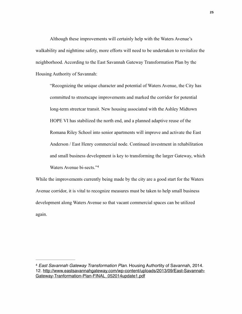
Although these improvements will certainly help with the Waters Avenue’s
walkability and nighttime safety, more efforts will need to be undertaken to revitalize the
neighborhood. According to the East Savannah Gateway Transformation Plan by the
Housing Authority of Savannah:
“Recognizing the unique character and potential of Waters Avenue, the City has
committed to streetscape improvements and marked the corridor for potential
long-term streetcar transit. New housing associated with the Ashley Midtown
HOPE VI has stabilized the north end, and a planned adaptive reuse of the
Romana Riley School into senior apartments will improve and activate the East
Anderson / East Henry commercial node. Continued investment in rehabilitation
and small business development is key to transforming the larger Gateway, which
Waters Avenue bi-sects.” 4
While the improvements currently being made by the city are a good start for the Waters
Avenue corridor, it is vital to recognize measures must be taken to help small business
development along Waters Avenue so that vacant commercial spaces can be utilized
again.
!
East Savannah Gateway Transformation Plan. Housing Authortity of Savannah, 2014. 4
12. http://www.eastsavannahgateway.com/wp-content/uploads/2013/09/East-Savannah-Gateway-Tranformation-Plan-FINAL_052014update1.pdf
25

CHAPTER 3 - FUTURE REVITALIZATION STRATEGIES
OVERVIEW
There are currently several businesses and residents located along the Waters
Avenue corridor, but the area has declined from the commercial hub that it used to be and
descended into a state of higher vacancy and disrepair. As formerly stated in chapter 2,
there are many issues with the target area that could be improved. These issues include
uneven sidewalks, drainage problems, inadequate lighting, underutilized commercial
buildings, a high amount of vacant lots, the lack of a grocery store, and negative
perceptions of the neighborhood by people who do not live there. The city of Savannah is
addressing some of these issues, but there is a substantial gap which must be bridged.
Although a challenging feat, a true revitalization of Waters Avenue must address all of the
issues and work with the stakeholders in order to make the corridor a better place to work
and live.
!SOLUTION 1- ENHANCEMENT OF PUBLIC COMMUNICATION
Community involvement is vital for a successful neighborhood revitalization. If
top-down plans are made to revitalize the street and the wants and needs of the residents
and stakeholders are not taken into consideration, it will only result in conflicts. There are
many stakeholders for the revitalization of Waters Avenue including property owners,
business owners, and the city. While there are currently organizations in place for
individual stakeholder groups, there is not a significant amount of conversation occurring
26
among the parties. If the city plans a revitalization attempt in the future, improving
communication lines between parties will be vital.
Since Waters Avenue is a boundary line for many neighborhoods, there are several
neighborhood associations to consider, including the Midtown Neighborhood
Association, the Baldwin Park Neighborhood Association, and the combined
neighborhood association belonging to the Eastside, Benjamin Van Clark, and Live Oak
neighborhoods. The Waters Avenue Business Association is a nonprofit organization that
represents the business owners in the area. The city should reach out to these stakeholder
groups to create smoother communication between all three parties in the form of a
public forums or meetings. If all parties come together, it will be a way to unite
grassroots interests in revitalization and make sure all voices are heard. Establishing an
online forum can also be a way to including the voices of younger generations or people
who cannot find the time to come to meetings. The resources necessary for this solution
involve a small amount of planning and funding, on the city’s behalf.
!SOLUTION 2 - SPECIAL EVENTS
Utilizing special events could be a way to attract Savannahians to experience
Waters Avenue. Establishing a similar event similar could showcase the positive aspects
of Waters Avenue and help to change people’s perceptions about the area. An infrequent
event, perhaps bi-monthly, could potentially showcase local culture including food,
music, and arts. These cultural assets are already available on Waters Avenue. Restaurants
27
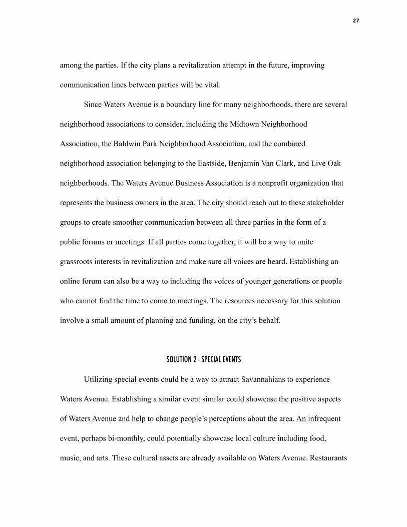
featuring local cuisine, artists studios, and a Jazz and Blues Lounge all lie within the
project boundary. Bringing these different aspects of Waters Avenue together for a special
event one night every few months could be a wonderful way to showcase what Waters
Avenue has to offer. This type of event could also be a way to temporarily activate the
empty lots that used to contain commercial buildings. The city currently owns several
consecutive plots of vacant land on the southwest corner of Waters Avenue and Anderson
Street, which could be an ideal place to set up event booths for information, food, artists,
or other local vendors. (see figure 20)
There are several resources necessary for this event, including funding and time
for planning and executing the event, as well as space to host it. One similar special event
Figure 20. Series of city-owned vacant lots, outlined in red, which could be utilized for an event space.
28

that already takes place in Savannah is the First Friday Art March, which showcases the
arts and creative businesses in the Starland district south of Forsyth Park. (see figure 21)
The event has become very successful and draws a lot of attention to the growing
neighborhood. On the First friday website, sponsors for the event include the city of
Savannah, the Georgia Council for the Arts, the National Endowment for the arts, as well
as several local businesses and newspapers. The event is organized by Art Rise 1
Savannah, a nonprofit organization committed to providing creative and financial
opportunities to local artists. To make an event like this be successful on Waters Avenue,
making similar partnerships will be crucial to funding the project and ensuring its
continued success.
"First Friday Art March." Accessed March 2, 2015. http://artmarchsavannah.com/.1
Figure 21: The First Friday Art March has been a way to enliven the streets, showcase the neighborhoods positive aspects, and given local vendors an economic opportunity.
29

SOLUTION 3 - COMMUNITY MARKET
Establishing an occasional, temporary community market could have several
positive impacts on the area. First, it would be a way to make nutritional produce
available to residents. Currently, there is no grocery store within the project site. While
the city of Savannah is currently trying to find a grocery store to become a tenant in the
shopping center located at the corner of Waters Avenue and 37th, the community market
could be a less expensive and temporary to bridge the gap until a more permanent
grocery store moves into the neighborhood. Additionally, the market could provide
spaces that could be incubators for local entrepreneurs who cannot initially afford rent of
a commercial space. There is a need for this along Waters Avenue - during site visits,
informal open-air commercial activities were taking place. If these spaces were offered
during an open-air farmers market, which could also attract more customers, an increase
in profit could potentially allow entrepreneurs to make enough money to transition into a
more permanent location.
Establishing a temporary farmers market could also take place on the city-owned
vacant lots shown in figure 1, which could be offered to vendors at little to no cost, with
city cooperation. However, there would be a cost to the city associated with cleaning up
and maintaining the empty lots. Currently, there is a mobile version of the Forsyth
Farmers Market, called Farm Truck 912, which is sponsored financially by Gulfstream
Aerospace Corporation’s Live Well Be Well initiative. The truck delivers fresh local
produce to different low-income locations around town, and accepts and double SNAP
30
and EBT benefits. One of these stops is at the WW Law Community Center, located on
Bolton street immediately west of the project site. It would be beneficial to reach out to
Farm Truck 912 and ask them to consider setting up a stop along Waters Avenue, and
potentially build partnerships grow a larger farmers market.
!SOLUTION 4 - URBAN DESIGN IMPROVEMENTS
There are many issues along Waters Avenue that could be addressed through
design improvements. The city has currently funded SPLOST dollars to build ornamental
lighting, brick sidewalks, and pedestrian crosswalks within the target area. Although
these projects are not yet underway, they will make vast improvements within the
commercial corridor. All of the streetscape improvements will have a positive impact on
the pedestrian experience. An improvement of street lighting will have a positive impact
on the safety of the street at night. Another problem with the area involves post-rain
flooding. The city has also allotted SPLOST funds to finance a project to improve
drainage for Eastside neighborhoods, including Waters Avenue, which will supposedly
alleviate the issue. Neither of these projects have taken place yet, but it will be crucial for
the city to follow through with these plans in order to revitalize the neighborhood.
Accommodating transportation is crucial to the area. Parking is noted as an issue
along the street, but the problem is more of a perception than a reality. Although Waters
Avenue is narrow and does not provide substantial on-street parking, there is ample street
parking on the residential streets intersecting Waters, and a multitude of large parking
31

lots. There has been talk about reintroducing a streetcar to Savannah which will
potentially run along Waters Avenue and Martin Luther King Jr. Boulevard. However,
these would be massively expensive for the city and would not pay for itself through
ticket sales. More feasible options for improving transit connectivity would be to
improve the bus and bike experience. There are 9 CAT bus stops along the target area, but
very few benches or shade shelters by the bus stops. Adding these amenities could help
improve the bus-riding experience and entice more people to take public transit.
Accommodating cyclists could also be valuable asset to Waters Avenue. Site visits
have shown many cyclists passing through the street. The target area is a cycling
thoroughfare between surrounding residential areas on the East, West, and South, and is
also connected to nearby Daffin Park. Adding unique decorative bike racks along Waters
Avenue could convince cyclists to stop along the corridor and visit local businesses.
Another improvement could be the addition of a bike lane. The road currently seems too
narrow to support a bike lane. However, it has this perception because there are
occasionally cars that are street-parked along Waters Avenue. There does not seem to be
enough room for street parking — cars in travel lanes have to maneuver partially into
lanes of oncoming traffic to avoid hitting street-parked cars. Perhaps a better option
would be to forbid street parking on Waters Avenue by painting the curbs yellow and
directing cars to park either on side streets or in larger parking lots. If this was
undertaken, there would be room for a bike lane so cyclists could safely share the road
with automobiles. If a safe bike lane and bike racks were introduced to the target area, a
32

greater number of cyclists would ride through the area, which could potentially attract
more commercial activity. However, these improvements would require monetary
resources through the city.
!SOLUTION 5 - INCREASING FUNDING
All of these improvements could help to revitalize the neighborhood, but are not
possible without capital. Although the city of Savannah can help to fund some
improvements along Waters Avenue, they cannot fund the entire revitalization of the
district, since they have to balance a budget for the needs of the entire city. There are
several strategies that could be made to help secure funding for revitalization attempts
within the target area.
Most of the target area currently lies outside of any National Register Historic
District. Only the north and south extremities lie within districts. Unfortunately, the bulk
of in-tact commercial architecture lies in the middle. Because of this, they are not eligible
for the 20% Historic Rehabilitation Tax Credit. Many of the historic commercial spaces
also do not qualify for the 10% historic tax credit, since it does not apply to buildings
built after 1936. Most of the commercial spaces along Waters Avenue were built shortly
after this time period. If the remaining parts of the district were listed as a National
Register Historic District, tax credits could help to incentivize outside development and
rehabilitate existing commercial buildings. One possibility could be establishing a
partnership between the city and Savannah College of Art and Design. Students of
33

Historic Preservation and Architectural History could gain experience in researching and
nominating a district to the National Register, and the city would benefit from their work.
Reaching out to the Historic Savannah Foundation (HSF) in regards to their
revolving fund could also be beneficial to help secure funding. HSF’s revolving fund has
saved over 350 historic buildings in Savannah. This process involves HSF’s acquisition
of properties through donations, options, or purchase. Then, the building is stabilized and
sold to a preservation-minded buyer with protective covenants attached to the deed.
Currently, HSF only uses its revolving fund for buildings located within one of
Savannah’s National Register districts. If the neighborhood is nominated to the National
Register, the Historic Savannah Foundation could likely use its revolving fund to help
find investors to rehabilitate the commercial spaces along Waters Avenue.
!EXPECTED RESULTS
With the changes suggested, a livelier Waters Avenue will result. Increasing
available funding to rehabilitate historic commercial buildings could create more spaces
for local businesses to operate. Increasing communication between stakeholders will
allow revitalization efforts to encompass multiple viewpoints and involve more people.
Occasional special events and a farmers market could showcase the positive aspects of
Waters Avenue and change people’s perceptions of the neighborhood while drawing
attention from locals in nearby neighborhoods. Urban design improvements could
improve the circulation spaces along the corridor and make walking and transportation
34

more pleasant. With all of these combined solutions, a more active business corridor
should be a result.
Economic activity will take place in the district again, and local residents will be
able to utilize commercial spaces close to home. The neighborhood could cultivate
entrepreneurship as small business owners would have a more affordable place to set up
restaurants, shops, or businesses away from the expensive and tourist-oriented downtown
Landmark District. There will be more people walking along the street, and an increase in
human eyes will allow for natural surveillance to further reduce crime in the area. The
neighborhood could provide an affordable place to live, work, and buy commercial
goods. Currently, neither downtown Savannah nor the suburbs can offer that. Waters
Avenue, lying between downtown and the suburbs, could be the ideal setting for a
renaissance of this closely tied commercial and residential community.
35

BIBLIOGRAPHY !City of Savannah Research Library and Municipal Archives. Savannah, Georgia
Spracher, Luciana. "Historic Benjamin Van Clark Neighborhood Trolleys to Today." In When The Meadows Became Van Clark. Savannah, 2004.
Working Class Savannah: Studying the Waters Avenue Neighborhood through Historical Archaeology. Atlanta, Georgia: TRC, 2006. !
Curl, Eric. "City Moving Forward with Waters Avenue Improvements." Savannah Morning News, August 22, 2013. !East Savannah Gateway Transformation Plan. Housing Authortity of Savannah, 2014. 12. http://www.eastsavannahgateway.com/wp-content/uploads/2013/09/East-Savannah-Gateway-Tranformation-Plan-FINAL_052014update1.pdf !Georgia Archives, University System of Georgia
Dixie Studio, photographer. “Konter’s Market.” Photograph. Savannah, c1940. Savannah. http://cdm.georgiaarchives.org:2011/cdm/singleitem/collection/vg2/id/3697/rec/3 !
Georgia Historical Society Foltz Photographic Studio Photographs, 1899-1860;
Cordray, Augusta K., photographer. “Waters Avenue at Bolton Street” Photograph. Savannah. 1931.
Foltz Photography Studio, photographer. “1111 Waters Avenue” Photograph. Savannah. 1947.
Foltz Photography Studio, photographer. “1516 Waters Avenue” Photograph. Savannah. 1950.
Foltz Photography Studio, photographer. “1908 Waters Avenue” Photograph. Savannah. 1946.
Foltz Photography Studio, photographer. “2201 Waters Avenue” Photograph. Savannah. 1935.
“Savannah 1898.” Sanborn Map. “Savannah 1916.” Sanborn Map.
Thomas Gable, Jr., A History of the Government of Savannah, Georgia, from 1790 to 1901, (Savannah: Savannah City Council, 1900), 29; “City of Savannah” (1812), M5 1018 Waring Map Collection, Vol. 2, Plate 12
“Savannah Southward Expansion.” Ward Notebook !"Interactive Crime Mapping." Savannah Chatham Metropolitan Police. Accessed February 14, 2015. http://www.savannahga.gov/index.aspx?NID=632. !!
36

Live Oak Public Library, Savannah, Georgia. Alonzo, Mary Beth. Streetcars of Chatham County: Photographs from the Collection of
the Georgia Historical Society. Charleston, S.C.: Arcadia, 1999. City Directory, City of Savannah, Georgia, 1891 City Directory, City of Savannah, Georgia, 1917 City Directory, City of Savannah, Georgia, 1920 City Directory, City of Savannah, Georgia, 1930 City Directory, City of Savannah, Georgia, 1940 City Directory, City of Savannah, Georgia, 1950 City Directory, City of Savannah, Georgia, 1960 City Directory, City of Savannah, Georgia, 1970 City Directory, City of Savannah, Georgia, 1980 City Directory, City of Savannah, Georgia, 1990 City Directory, City of Savannah, Georgia, 2000 City Directory, City of Savannah, Georgia, 2010 !"Savannah, Georgia." City Data. Accessed February 14, 2015. http://www.city-data.com/city/Savannah-Georgia.html. !"SPLOST." Savannah, GA. Accessed February 5, 2015. http://www.savannahga.gov/index.aspx?NID=1300. !“Waters Road - Automobile Race Course.” Photograph. Savannah. 1910. http://www.vanderbiltcupraces.com/blog/article/then_now_1911_vanderbilt_cup_race_course-_waters_street_savannah
37