watershed assessment of the - british...
TRANSCRIPT
General Disclaimer The use of trade, firm, or corporation names in this publication is for the information and convenience of the reader. Such use does not constitute an official endorsement or approval by the Government of British Columbia of any product or service to the exclusion of any others that may also be suitable. Contents of this report are presented as information only. Funding assistance does not imply endorsement of any statements or information contained herein by the Government of British Columbia. Uniform Resource Locators (URLs), addresses, and contact information contained in this document are current at the time of printing unless otherwise noted.
Disclaimer of Liability With respect to documents available from this server, neither the Government of British Columbia nor any of their employees, makes any warranty, express or implied, including the warranties of merchantability and fitness for a particular purpose, or assumes any legal liability or responsibility for the accuracy, completeness, or usefulness of any information, apparatus, product, or process disclosed, or represents that its use would not infringe privately owned rights.
Watershed Assessment of the
BX Creek Community Watershed
Prepared for:
Small Business Forest Enterprise Program Ministry of Forests
Vernon Forest District Vernon, BC
Prepared by:
Chapman Geoscience Ltd. 2723 Neyland Road
Nanaimo, BC V9T 4E1
Phone: (250) 758-0090 Fax: (250) 758-0042
Email: [email protected]
January 1999
TABLE OF CONTENTS 1. INTRODUCTION ...................................................................................................................................................1
2. METHODOLOGY ..................................................................................................................................................5
SUB-BASIN DELINEATION ..........................................................................................................................................5 EQUIVALENT CLEARCUT AREA (ECA) CALCULATION ..............................................................................................6 DIGITAL ROAD FILE...................................................................................................................................................8 GIS............................................................................................................................................................................8 FIELD WORK..............................................................................................................................................................8
3. WATERSHED DESCRIPTION ............................................................................................................................8
4. OBSERVATIONS AND RESULTS.....................................................................................................................11
A. EQUIVALENT CLEARCUT AREA MEASUREMENTS ...............................................................................................11 B. TERRAIN AND SLOPE STABILITY .........................................................................................................................14 C. ROADS ................................................................................................................................................................14 F. STREAM CHANNEL CONDITIONS..........................................................................................................................15
BX Mainstem, at City of Vernon water intake....................................................................................................16 BX Mainstem, 2 km above City of Vernon water intake.....................................................................................16 BX Mainstem, 2 km above Abbott Creek (at Forsberg Road)............................................................................16 BX Mainstem, at Silver Star Provincial Park boundary ....................................................................................16 Brookside Creek, at Crown land boundary .......................................................................................................16 Brookside Creek, lower (at road crossing) ........................................................................................................17 Dixon Creek, 2 km below Dixon Dam................................................................................................................17 Dixon Creek, above Dixon Dam ........................................................................................................................17 Summary of Channel Conditions .......................................................................................................................17
5. DISCUSSION OF CURRENT WATERSHED CONDITIONS........................................................................18
5. PROPOSED FOREST DEVELOPMENT ..........................................................................................................18
6. CONCLUSIONS AND RECOMMENDATIONS ..............................................................................................21
Appendices 1. Equivalent Clearcut Area Calculations 2. Equivalent Clearcut Area Calculations for the Forest Development Plan 3. Selected Site Photos 4. Water Survey of Canada data 5. Water License data for Brookside Creek
BX Creek Watershed Assessment page 1
Chapman Geoscience Ltd. Final Report Forest Hydrology and Geomorphology 25-Jan-99
Watershed Assessment of the BX Creek Community Watershed, Vernon Forest District
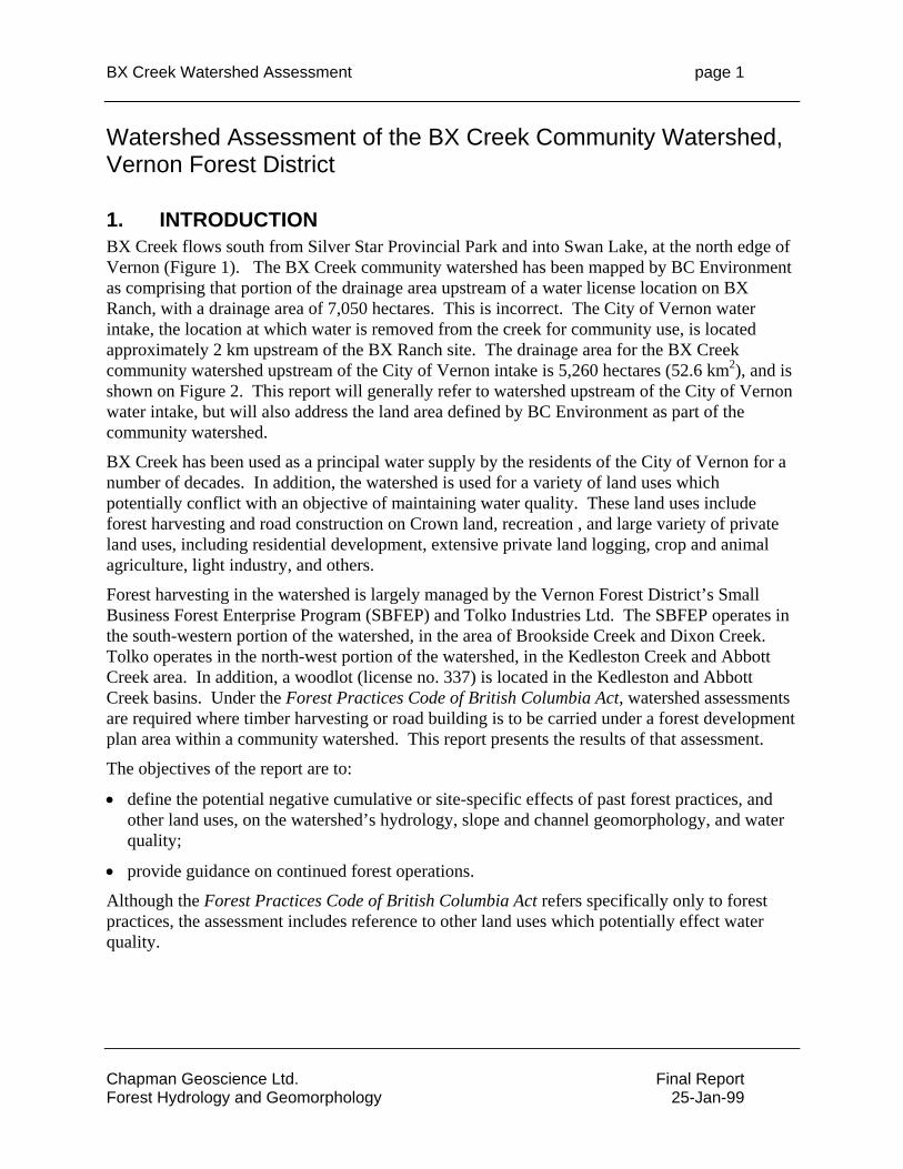
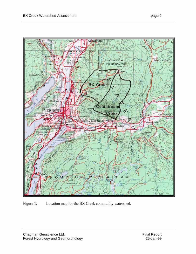
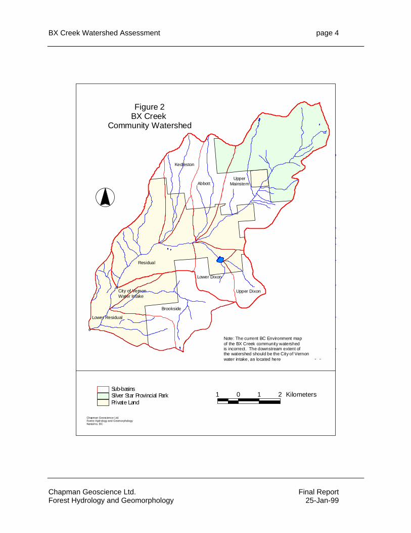
1. INTRODUCTION BX Creek flows south from Silver Star Provincial Park and into Swan Lake, at the north edge of Vernon (Figure 1). The BX Creek community watershed has been mapped by BC Environment as comprising that portion of the drainage area upstream of a water license location on BX Ranch, with a drainage area of 7,050 hectares. This is incorrect. The City of Vernon water intake, the location at which water is removed from the creek for community use, is located approximately 2 km upstream of the BX Ranch site. The drainage area for the BX Creek community watershed upstream of the City of Vernon intake is 5,260 hectares (52.6 km2), and is shown on Figure 2. This report will generally refer to watershed upstream of the City of Vernon water intake, but will also address the land area defined by BC Environment as part of the community watershed.
BX Creek has been used as a principal water supply by the residents of the City of Vernon for a number of decades. In addition, the watershed is used for a variety of land uses which potentially conflict with an objective of maintaining water quality. These land uses include forest harvesting and road construction on Crown land, recreation , and large variety of private land uses, including residential development, extensive private land logging, crop and animal agriculture, light industry, and others.
Forest harvesting in the watershed is largely managed by the Vernon Forest District’s Small Business Forest Enterprise Program (SBFEP) and Tolko Industries Ltd. The SBFEP operates in the south-western portion of the watershed, in the area of Brookside Creek and Dixon Creek. Tolko operates in the north-west portion of the watershed, in the Kedleston Creek and Abbott Creek area. In addition, a woodlot (license no. 337) is located in the Kedleston and Abbott Creek basins. Under the Forest Practices Code of British Columbia Act, watershed assessments are required where timber harvesting or road building is to be carried under a forest development plan area within a community watershed. This report presents the results of that assessment.
The objectives of the report are to:
• define the potential negative cumulative or site-specific effects of past forest practices, and other land uses, on the watershed’s hydrology, slope and channel geomorphology, and water quality;
• provide guidance on continued forest operations.
Although the Forest Practices Code of British Columbia Act refers specifically only to forest practices, the assessment includes reference to other land uses which potentially effect water quality.
BX Creek Watershed Assessment page 2
Figure 1. Location map for the BX Creek community watershed.
Chapman Geoscience Ltd. Final Report Forest Hydrology and Geomorphology 25-Jan-99
BX Creek Watershed Assessment page 3
Chapman Geoscience Ltd. Final Report Forest Hydrology and Geomorphology 25-Jan-99
BX Creek Watershed Assessment page 4
#0
#0City of VernonWater Intake
Residual
UpperMainstemAbbott
Brookside
Kedleston
Lower Residual
Lower Dixon
Upper Dixon
Chapman Geoscience Ltd.Forest Hydrology and GeomorphologyNanaimo, BC
1 0 1 2 KilometersPrivate LandSilver Star Provincial ParkSub-basins
Figure 2BX Creek
Community Watershed
Note: The current BC Environment map of the BX Creek community watershed is incorrect. The downstream extent of the watershed should be the City of Vernon water intake, as located here
Chapman Geoscience Ltd. Final Report Forest Hydrology and Geomorphology 25-Jan-99
BX Creek Watershed Assessment page 5
Chapman Geoscience Ltd. Final Report Forest Hydrology and Geomorphology 25-Jan-99
2. Methodology The Interior Watershed Assessment Guidebook (Anon., 1995) is used as the general reference for this watershed assessment. The 1995 guidebook underwent review and revision during 1998, with the production of a draft 2nd revision of the IWAP. As of December, 1998, the revised IWAP has not yet been released as an official Forest Practices Code Guidebook. However, a document summarizing the expected scope and content of watershed assessments was produced by the Kamloops Forest Region (Anon., 1998) to assist professionals until such time as the revised IWAP is released. The BX Creek watershed assessment reported here corresponds to the scope and content of the Kamloops Forest Region guidelines as well as the draft 2nd revision of the IWAP1.
In general, the major changes from the 1995 IWAP to that used for this report, include:
1. Reduced reliance on map-generated information to produce indicators of potential watershed conditions;
2. Increased use of aerial photographs to observe and interpret hillslope and stream channel conditions;
3. Increased reliance on field assessments, including road condition assessments, reconnaissance stream channel assessments, and sediment source evaluation; and
4. Increased reliance on experienced, professional interpretation of watershed conditions.
To complete the office component of the BX Creek watershed assessment, the following information was used:
• 1994 colour aerial photographs at a scale of 1:20,000;
• 1997 black and white aerial photographs at a scale of 1:50,000;
• TRIM topographic maps (82L.024, 82L.025, 82L.034, 82L.035) at a scale of 1:20,000;
• Terrain and terrain stability maps at a scale of 1:20,000, produced by Golder Associates;
• Stream discharge data for BX Creek at the City of Vernon Intake, Water Survey of Canada gauge 08NM020;
• Climate data measured Vernon Coldstream Ranch;
• Digital map files for forest cover, TRIM streams, TRIM topography, and roads, provided by the Vernon Forest District (the forest cover data were for revision year 1995). These files were NAD83, Albers Equal Area projection.
Sub-basin Delineation The BX Creek watershed was divided into a number of sub-basins for the purpose of the watershed assessment. Four sub-basins and a residual area were defined, as summarized in
1 Allan Chapman, P.Geo., served as a reviewer of the draft revised Interior Watershed Assessment Procedure guidebook for the Association of Professional Engineers and Geoscientists of British Columbia.
BX Creek Watershed Assessment page 6
Chapman Geoscience Ltd. Final Report Forest Hydrology and Geomorphology 25-Jan-99
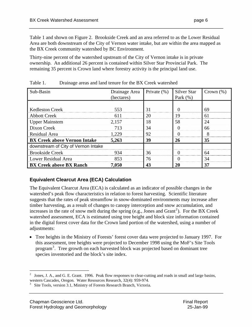
Table 1 and shown on Figure 2. Brookside Creek and an area referred to as the Lower Residual Area are both downstream of the City of Vernon water intake, but are within the area mapped as the BX Creek community watershed by BC Environment.
Thirty-nine percent of the watershed upstream of the City of Vernon intake is in private ownership. An additional 26 percent is contained within Silver Star Provincial Park. The remaining 35 percent is Crown land where forestry activity is the principal land use.
Table 1. Drainage areas and land tenure for the BX Creek watershed
Sub-Basin Drainage Area (hectares)
Private (%) Silver Star Park (%)
Crown (%)
Kedleston Creek 553 31 0 69 Abbott Creek 611 20 19 61 Upper Mainstem 2,157 18 58 24 Dixon Creek 713 34 0 66 Residual Area 1,229 92 0 8 BX Creek above Vernon Intake 5,263 39 26 35 downstream of City of Vernon Intake Brookside Creek 934 36 0 64 Lower Residual Area 853 76 0 34 BX Creek above BX Ranch 7,050 43 20 37
Equivalent Clearcut Area (ECA) Calculation The Equivalent Clearcut Area (ECA) is calculated as an indicator of possible changes in the watershed’s peak flow characteristics in relation to forest harvesting. Scientific literature suggests that the rates of peak streamflow in snow-dominated environments may increase after timber harvesting, as a result of changes to canopy interception and snow accumulation, and increases in the rate of snow melt during the spring (e.g., Jones and Grant2). For the BX Creek watershed assessment, ECA is estimated using tree height and block size information contained in the digital forest cover data for the Crown land portion of the watershed, using a number of adjustments:
• Tree heights in the Ministry of Forests’ forest cover data were projected to January 1997. For this assessment, tree heights were projected to December 1998 using the MoF’s Site Tools program3. Tree growth on each harvested block was projected based on dominant tree species inventoried and the block’s site index.
2 Jones, J. A., and G. E. Grant. 1996. Peak flow responses to clear-cutting and roads in small and large basins, western Cascades, Oregon. Water Resources Research, 32(4): 959-974. 3 Site Tools, version 3.1, Ministry of Forests Research Branch, Victoria.
BX Creek Watershed Assessment page 7
Chapman Geoscience Ltd. Final Report Forest Hydrology and Geomorphology 25-Jan-99
• Some logging in the BX Creek watershed was done using non-clearcut methods, including seed tree, shelterwood and selection harvesting. An estimate of residual old growth trees remaining on each harvested block was made by interpretation of the 1995 aerial photographs,. The block area for ECA purposes was prorated as the percentage of old growth trees logged (e.g., a 10 hectare block logged with 20% of trees remaining as residuals was counted as an area of 8 ha for ECA purposes).
• Some areas reported in the MoF’s digital forest cover files as being logged or burned were considered as 100 percent recovered (not as 90% recovered, as the IWAP guidebook suggests). This was done for blocks reported as having 80-110 year old forests, with tree heights similar to those shown for adjacent non-harvested areas, and where air photo interpretation indicated no difference between the blocks reported as logged and adjacent areas reported as non-harvested. In some of these areas, limited single tree selection harvesting for insect control may have been carried out.
• Large areas of private land logging were photo interpreted as to their tree regeneration characteristics, with ground truthing of some blocks. No attempt was made to define the “harvested” portion of the large extent of private land used for residential and small acreage rural development.
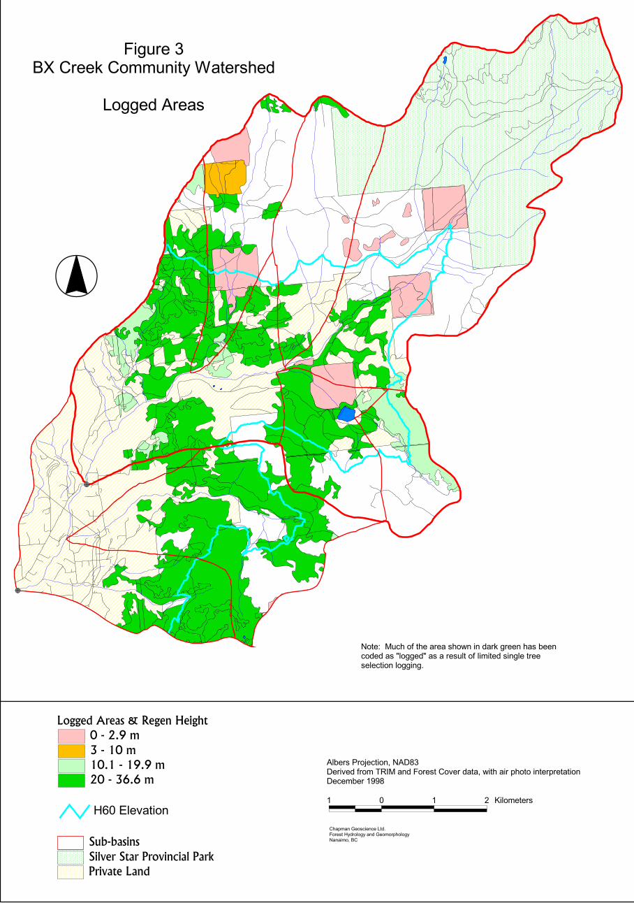
Using the method outlined in the 1995 IWAP guidebook, hydrologic “recovery” was estimated using the simple approach shown in Table 2. A summary of all logged blocks and the associated ECA calculations is shown in Appendix 1. These ECA estimates are projected to December 1998. Areas classified as logged or burned on the digital forest cover maps are shown on Figure 3 (with some corrections based on air photo interpretation).
To evaluate the effects of tree growth on ECA, ECA values for the BX Creek watershed were calculated for 5 years, 10 years and 20 years into the future. Tree growth was estimated using the Ministry of Forests’ Site Tools program, with tree height projected for each harvested block based on dominant inventoried tree species and the block’s site index. These results are also shown in Appendix 1.
Because of the large extent of private land, ECA estimates for BX Creek will be subject to some uncertainty. Where it is considered important, the degree of uncertainty is discussed and interpreted in sections of this report.
BX Creek Watershed Assessment page 8
Chapman Geoscience Ltd. Final Report Forest Hydrology and Geomorphology 25-Jan-99
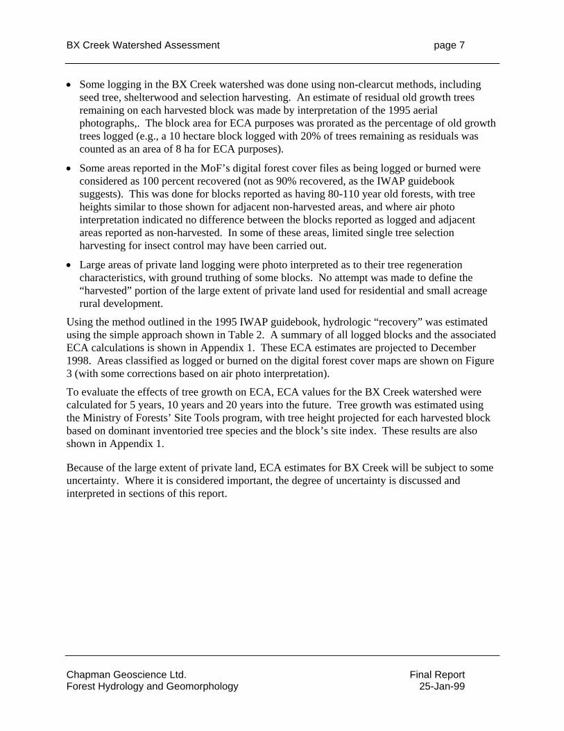
Table 2. Estimated hydrologic recovery for ECA calculation, from the IWAP guidebook
Tree Height (m) % Recovery
0 - 2.9 m 0% 3.0 - 4.9 25% 5.0 - 6.9 50% 7.0 - 8.9 75% 9.0 + 90% Digital Road File The roads depicted on the digital files provided by the MoF were incomplete. It was necessary to update the road file to ensure that all roads in the watershed were included. This was done by digitizing roads from the 1997 black and white air photos. In addition, some “roads” contained on the digital file were not visible on 1:20,000 air photos, and were considered to be trails. These were removed from the analysis.
GIS All digital map analysis was conducted using ArcView 3.0a GIS. Digital map files were NAD83, Albers Equal Area projection.
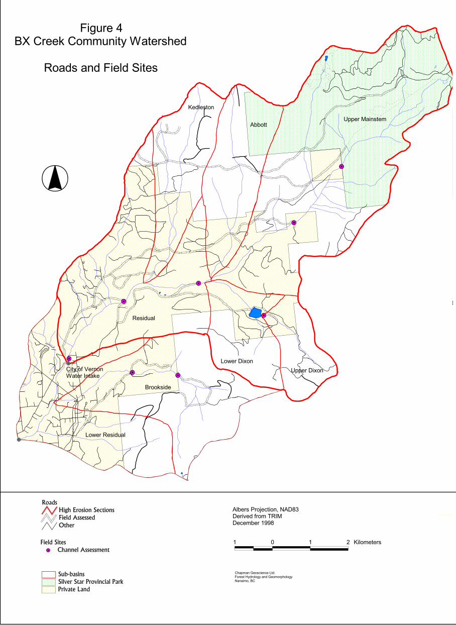
Field Work Field work consisted of road condition assessments, sediment source evaluation and stream channel assessments, conducted during November 10-13, 1998.
Most active, maintained forestry roads, some private land roads, and selected inactive, unmaintained forestry roads were driven and assessed for surface hydrology, fine sediment erosion and landsliding. Locations of roads driven and assessed are shown on Figure 4.
Stream channels were field assessed at a number of locations on mainstem and tributary channels. The purpose of the channel assessment is to evaluate and classify channel type and natural channel sensitivity, and to determine whether channel disturbances exist. If channel disturbances exist, they are classified and an attempt is made to determine the natural or land use-related factors that might be related to the disturbance. Locations of channels assessed are shown on Figure 4.
3. Watershed Description The BX Creek community watershed is located in the Thompson-Okanagan Plateau, north of Vernon. Elevations in the watershed range from about 620 m at the municipal intake, to almost 1,890 m at Silver Star Mountain. Relief is generally gentle.
BX Creek Watershed Assessment page 9
Chapman Geoscience Ltd. Final Report Forest Hydrology and Geomorphology 25-Jan-99
Figure 3
��
��
������������������������������������
�� ������������� ������ ��
�������������������������������������� �!"�"�����
������������ ����������� ����������������������������������� � �� ��! �� ����!����� ����������"##�
� �!����$��� �����%��&������'(���)(�����$���! �)(���� ���*�
" + " , - �������
� ).����*/�����0����.� �(�1����� ��
%))��������
���2���.� ���� �������� ��� �����0�)����� ���������������3�))��3���������.������ � ����� �)������������� ���)) �)&
'4+�5����� �
BX Creek Watershed Assessment page 10
Chapman Geoscience Ltd. Final Report Forest Hydrology and Geomorphology 25-Jan-99
Figure 4
��
����
��
��
��
����
��
��
��
����
��
��
��
��
��
����
��
��
��
��
��������
��� �������������
���������
���������
��������������
���������������������������������
������ �����
!�"����#�$�����������������������%��
����������!�����&����
' ( ' ) ����������
�%�����*���+���+�����,!������-������"������*�����%���"�.������/���
�������0��1�+����/�.��23����4��������5� ��+������'662
������������ �� ������� �
�������������� ������� ���������������
���������� ������������������ ����������������
BX Creek Watershed Assessment page 11
Chapman Geoscience Ltd. Final Report Forest Hydrology and Geomorphology 25-Jan-99
The watershed is underlain by a variety of bedrock types, with mostly sedimentary rocks in the northern portion of the watershed and volcanics in the south. Overlying the bedrock are a variety of surficial materials. Veneers and blankets of sandy silty till are common, with smaller amounts of colluvial material scattered throughout the watershed. Most stream valleys narrow deposits of fluvial and glaciofluvial sediments ranging from sand to cobble in size.
Precipitation in the watershed varies from about 450 mm at low elevation (as measured at Coldstream Ranch) to an estimate of about 1,100 mm at high elevation. The estimated mean annual precipitation averaged over the watershed is about 650 mm. About 28 percent of this precipitation occurs as snow during the November to April period. The annual precipitation is somewhat evenly distributed across the seasons, with the greatest precipitation often occurring in December and the least in March. Spring rainfall during May and June is not uncommon, and can contribute to rain-on-snow runoff events, as occurred during 1996.
BX Creek at the City of Vernon intake had a mean annual runoff of 180 mm over the 1960-1997 period (the difference between mean annual precipitation and mean annual runoff is estimated evapotranspiration). BX Creek is a snow dominated stream, with most of the annual runoff occurring during the spring snowmelt period. Over the 1960-1997 period, the annual maximum streamflow generally occurs during the late April - early May period. Almost 35 percent of the annual runoff occurs during the 30 day period of April 16 - May 15.
The largest discharge during 42 years of stream flow record occurred on May 31, 1996, as the result of a large rain occurring near the end of the snowmelt period. At this time the soil was saturated from snowmelt in April and early May, and some snow still existed on the ground at high elevations in the watershed. The daily average peak discharge of nearly 9.6 m3/s was 2 times larger than the next largest peak discharge in 42 years. A frequency analysis indicates that this 1996 flood corresponds to greater than a 100 year return period event4. These results are consistent with those from the nearby Coldstream Creek. The stream flow data for BX Creek for the period of record are summarized in Appendix 4.
4. Observations and Results As a component of a watershed assessment, a number of indicators of watershed condition and land use are measured from air photos and maps, and tabulated. These indicators are summarized in Table 3 and discussed below. The results of the field assessments are also presented below.
A. Equivalent Clearcut Area Measurements The overall ECA for the BX Creek community watershed is estimated from GIS analysis to be about 645 hectares, 9.7 percent of the watershed area. Because some private land clearing is not included, this estimate might be low by 1-2 percent. With the exception of Kedleston Creek, ECA levels within the sub-basins are low, ranging from 5-12 percent of the sub-basin area.
4 Using a Log Pearson III statistical distribution to analyze the 1968-1996 annual daily extreme peak flow data, and computing the return period of the 1996 peak discharge from that model.
BX Creek Watershed Assessment page 12
Chapman Geoscience Ltd. Final Report Forest Hydrology and Geomorphology 25-Jan-99
Kedleston Creek has an ECA of 21 percent, the highest level in the watershed. This ECA results from a combination of Crown and private land logging.

BX Creek Watershed Assessment page 13
Chapman Geoscience Ltd. Final Report Forest Hydrology and Geomorphology 25-Jan-99
BX Creek Watershed Assessment page 14
Chapman Geoscience Ltd. Final Report Forest Hydrology and Geomorphology 25-Jan-99
The ECA value for the overall watershed is such that a concern for harvesting-related hydrological changes in BX Creek is low.
As trees continue to grow on the previously harvested blocks, the ECA values will decrease. Because the silvicultural status of private land areas is unknown, it is not possible to forecast tree growth into the future to estimate ECA reduction. This is not considered to be a critical question for the BX Creek watershed, as ECA levels are low and are unlikely to increase rapidly over the next 5-10 year period unless a large amount of private land logging is done.
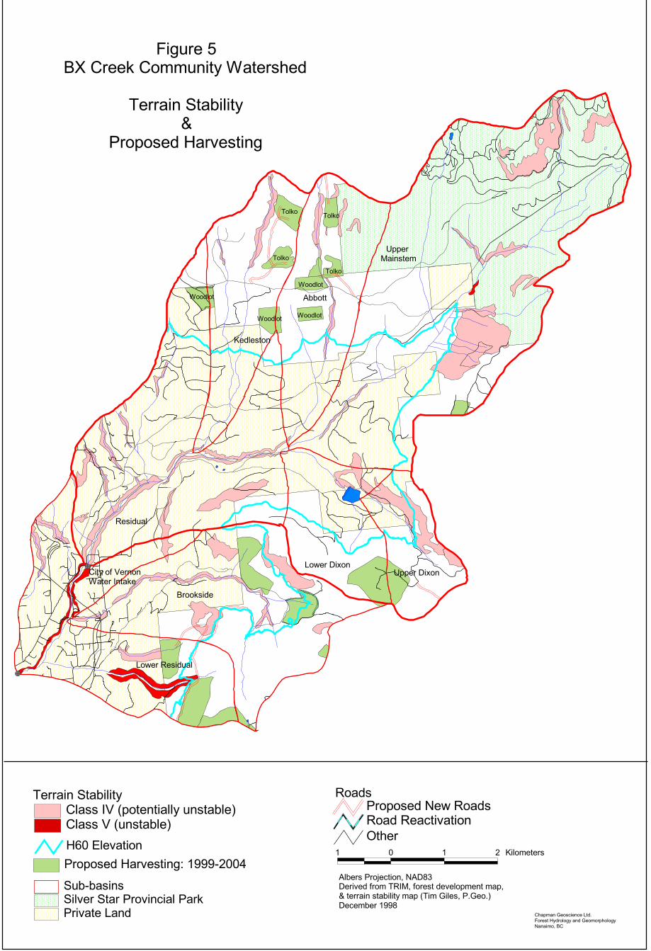
B. Terrain and Slope Stability In general, landsliding is not a significant problem in the BX Creek watershed. About 8.6 percent of the BX Creek community watershed has been mapped by Golder Associates as unstable (stability class V) or potentially unstable (stability class IV). Most of this area is stability class IV terrain. These areas are shown on Figure 5. Areas of potentially unstable terrain are predominantly:
• Glaciofluvial deposits located proximal to the lower mainstem channel of BX Creek These include steep escarpments along the edge of the creek.
• Moderate-to steeply-sloped glacial till deposits along the mid-reaches of BX Creek and some tributary creek channels, such as Brookside Creek and Kedleston Creek.
• Areas of moderate- (28-55%) and steeply-sloped (55-90%) glacial till, with high silt and sand content, situated along the east side of the watershed, particularly in the Dixon Creek sub-basin and below the south-eastern boundary of Silver Star Provincial Park (Note: Some of these till slopes mapped by Golder Associates as stability class IV are not steep, and their interpretation as potentially unstable is very conservative.)
A total of 6 landslides were noted in the BX Creek watershed. All are very small with no significant impact on BX Creek. Two of the slides are road fill failures which did not deposit into the creek, and three are small, natural slides on steep escarpment slopes along the banks of stream channels, and one is a very small debris slide on a logged slope (private land logging).
C. Roads Forest roads are considered be to a significant factor in potential forestry-related effects on water quality or peak streamflow. The main effects are related to fine-sediment erosion from the running surface, cut slope and ditch lines of roads, and the potential for roads to increase peak stream flow rates by directing water to streams from hillslopes faster than if the roads did not exist.
The MoF’s digital map files show the BX Creek community watershed as containing a total of 111 km of roads (2.1 km/km2). These roads were initially assessed on 1:20,000 air photos, and interpreted to one of the following general classes:
1. Active, maintained;
2. Inactive, minimal or no maintenance;
BX Creek Watershed Assessment page 15
Chapman Geoscience Ltd. Final Report Forest Hydrology and Geomorphology 25-Jan-99
3. Abandoned trail.
A portion of the roads were driven and assessed for running surface erosion, cutslope failures or erosion, ditch erosion, water concentration in ditch lines, and erosion or disturbance at stream crossings. These roads included most active forestry roads, most drivable but unmaintained roads on Crown land, and a number of forestry and other roads on private land.
The field assessment indicates the following:
1. Most roads in the watershed are fine, and are not contributing significant amounts of fine sediment to stream channels. No active forest roads were assessed as having high erosion concern.
2. A number of old, unmaintained roads in the Brookside Creek and Dixon Creek sub-basins are experiencing some surface erosion. The roads are abandoned, and appear to have been extensively used for motorcycle and other off-road recreation vehicles. The road surfaces are extensively gullied from surface water drainage and recreation use. They are possibly minor contributors of sediment to streams in the Brookside basin (which discharges into BX Creek downstream of the City of Vernon intake, and is not part of the community watershed), but probably are not sediment contributors in Dixon Creek. This portion of the Dixon Creek sub-basin, upstream of Dixon Dam, is very dry, and no surface water was observed during the field assessment.
3. None of the private land roads assessed were considered to be significant sediment contributors to BX Creek. However, one road with a crossing of BX Creek was noted as having a 1.8 m diameter culvert that was undersized relative to the size of the creek.
F. Stream Channel Conditions Stream channel characteristics and disturbance was assessed at 7 locations in the watershed (Figure 4). All streams were in low flow conditions at the time of the field assessment. Reaches field assessed include:
• BX mainstem, at City of Vernon water intake;
• BX mainstem, 2 km above City of Vernon water intake;
• BX mainstem, 2 km above Abbott Creek (at Forsberg Road);
• BX mainstem, at Silver Star Provincial Park boundary;
• Brookside Creek, at Crown land boundary;
• Brookside Creek, lower;
• Dixon Creek, 2 km below Dixon Dam.
• Dixon Creek, upstream of Dixon Dam
The results are as follows.
BX Creek Watershed Assessment page 16
Chapman Geoscience Ltd. Final Report Forest Hydrology and Geomorphology 25-Jan-99
BX Mainstem, at City of Vernon water intake The BX Creek mainstem above the City of Vernon intake has an average width of approximately 5-7 m, with a gradient of 3%. Riparian vegetation is a mix of deciduous and coniferous, and has been disturbed. Bed material is dominated by cobble and boulder, with a step-pool morphology. The channel is largely non-alluvial, and is slightly incised into till. Narrow bands of alluvial gravel and floodplain are found along portions of the channel, and periodic exposures of bedrock are common. Bank erosion is evident along the 2000 m that were assessed. A small channel avulsion is located upstream of the intake. Most of the disturbance appears recent, and is possibly related to the May 1996 period of record high discharge. A recreational walking trail winds its way through the riparian zone, along the creek, for about 2000 m above the intake. At the time of the field assessment, two young men were yarding a tree across the creek (using a winch on a truck which they had managed to get down to the creek), and apparently were preparing to buck it up into firewood. This reach is considered to be moderately sensitive to disturbance, as a result of the periodic alluvial bank material, and it is assessed to be moderately disturbed.
BX Mainstem, 2 km above City of Vernon water intake BX Creek at this location is about 5 m wide, with a gradient of 5-7%. Bedrock is exposed on both banks over most of the 400 m that were assessed. Some evidence of the recent high flow was apparent along the channel, but disturbance was minimal. Because of the bedrock-dominated banks, this reach is quite insensitive to disturbance.
BX Mainstem, 2 km above Abbott Creek (at Forsberg Road) BX Creek at this road crossing has a boulder-cobble bed, with a width of about 4 m and a gradient of about 4-5 %. The channel is non-alluvial, and is incised slightly into glacial till banks. Some minor bank erosion is evident. The circular steel culvert for the road crossing of BX Creek appears to be too small. The creek is 4 m wide while the culvert has a diameter of 1.8 m.
BX Mainstem, at Silver Star Provincial Park boundary BX Creek at the Silver Star Provincial Park boundary has a boulder-cobble bed, with a width of 4 m and a gradient of 4-5 m. The channel is non-alluvial, and is incised slightly into glacial till banks. Both banks have been logged (private land logging). Erosion is evident along some sections of bank. Several small debris slides have occurred from the steep logged stream bank, with all the slides depositing in the creek. Debris jams, comprised of wood and coarse sediment, have formed in the creek, possibly related to the post-logging bank instability. The channel is moderately disturbed, with the disturbance apparently mostly related to the private land riparian logging activity.
Brookside Creek, at Crown land boundary Brookside Creek at the Crown land boundary is very small, about 1 m wide, with a gradient of 2-3 %. Bed material is a mix of sand, gravel and cobble. The channel is non-alluvial, and is
BX Creek Watershed Assessment page 17
Chapman Geoscience Ltd. Final Report Forest Hydrology and Geomorphology 25-Jan-99
flowing through till. Woody debris is common along the channel. No significant disturbance was noted.
Brookside Creek, lower (at road crossing) At this location, Brookside Creek is about 1 ½ m wide, a gradient of about 3-4 %. Bed material is dominated by cobbles, with some gravel. A large gravel and sand deposit has accumulated in the culvert inlet, and the inlet is now partially plugged. At this point, it has flowed through private land for greater than 1 km.
Dixon Creek, 2 km below Dixon Dam Dixon Creek is so small it is barely discernible. The channel is <1 m wide, and is incised into till. Bed material is a mix of sand, gravel and cobbles. Overgrowing vegetation is abundant. No disturbance is apparent.
Dixon Creek, above Dixon Dam The eastern shore of Dixon dam was walked, but no evidence of a surface water channel was found. Summary of Channel Conditions The mainstem reach of BX Creek shows evidence of some disturbance, mostly periodic bank erosion. It is likely that the majority of the disturbance is related to the May 1996 record stream discharge (estimated to be >100 year return period). The bank erosion was not severe, and it is unlikely that significant negative effects on drinking water quality are still occurring as a consequence. The lower ¾ of the mainstem channel is dominated by a variety of private land uses. The effects of these land uses were not specifically assessed, but no stream disturbance on private land was apparent on the air photos. However, at one location just below the Silver Star Provincial Park boundary, private land logging was clearly related to significant bank and stream disturbance. This disturbance, from riparian logging, resulted in impacts in the channel at that site, but it is unlikely that negative effects would have been manifested at the water intake, about 9 km downstream.
Dixon Creek and Brookside Creek are both very small, low discharge channels. With their low elevation in the watershed they receive small amounts of precipitation. Most of this water is probably utilized by the forested vegetation through transpiration, and little water remains to be discharged as surface runoff. No disturbance was apparent in either stream, and it is unlikely that logging in the SBFEP portion of the watershed has had any negative effects on water quality. For Dixon Creek above Dixon Dam, a surface water stream channel could not be found. The potential for forestry activity upstream of Dixon Dam to have any effect on water quality is therefore extremely remote. As an additional factor, Dixon Dam would serve to store most sediment that enters it, and would prevent that sediment from being transported to BX Creek.
Abbott Creek and Kedleston Creek were examined at road crossings. Both creeks are very small (1-1 ½ m). No disturbance was observed.
BX Creek Watershed Assessment page 18
Chapman Geoscience Ltd. Final Report Forest Hydrology and Geomorphology 25-Jan-99
5. Discussion of Current Watershed Conditions This assessment indicates that the BX Creek watershed is generally in good condition and that Crown land forestry activity has not resulted in negative effects on stream channels or water quality. The overall watershed and all the individual sub-basins appear to have no stream flow problem related to land use change, and landslide activity is insignificant. About ¾ of the mainstem channel is dominated by a variety of private land uses, including logging, recreation, residential development, and small-scale agriculture. It is possible that these activities are having some level of water quality effect (particularly bacteriological), but it was not discernible in this assessment. Air photo interpretation indicated that most of the riparian forest along BX Creek is intact, and, with one exception, there was no evidence of channel disturbance related to private land activity. One private land site, just below the Silver Star Provincial Park boundary, has been logged a few years ago. A number of small debris slides along the stream bank have occurred since the logging, and are probably related to the logging.
The mainstem channel of BX Creek exhibits minor bank erosion. This is probably related to the large discharge event that occurred in May 1996. As noted earlier in this report, that discharge was the largest measured over 40+ years of record, and is estimated to have a return period of >100 years. In the 2 km reach immediately upstream of the City of Vernon water intake, no significant disturbance other than this minor bank erosion was noted.
This assessment indicates that past Crown land forestry activity in the BX Creek is unlikely to have resulted in any impact on water quality. For the SBFEP portion of the watershed (largely Dixon Creek and Brookside Creek) no stream disturbance was noted. The extent of past harvesting activity has been low, and current ECA levels are very low. Old, abandoned roads in both sub-basins are rutted and eroding and in need of low level deactivation. In the case of Dixon Creek, however, the roads are not contributing sediment to stream channels and have no potential to affect water quality. In the Brookside Creek sub-basin, the road disturbance appears to be old, and appears to be relatively benign at this time in regard to potential water quality effects. In any case, Brookside Creek discharges into BX Creek below the City of Vernon intake, and is not part of the community water supply.
For the Tolko Industries Ltd. operating area in Kedleston Creek and Abbott Creek, no problems were noted. The new forestry road is well constructed and is not a sediment source. The extent of past harvesting activity has been low, and current ECA levels are not a concern. An examination of these two small creeks at road crossings noted no disturbance.
5. Proposed Forest Development Forest development plans for the Ministry of Forests’ SBFEP, Tolko Industries Ltd. and Woodlot 337 contain a number of blocks proposed or approved for the BX Creek watershed. These are summarized by sub-basin in Table 5, and are shown on Figure 5. Approximately 200 hectares (3.8 % of the watershed area) is proposed for development over the 1999-2004 period5. The SBFEP harvesting is proposed for a variety of non-clearcut silvicultural techniques,
5 Block areas were digitized from the 1:20,000 Forest Development Plan map and may be subject to a small measurement error.
BX Creek Watershed Assessment page 19
Chapman Geoscience Ltd. Final Report Forest Hydrology and Geomorphology 25-Jan-99
including single tree selection, group selection, shelterwood and seed tree, while the Tolko blocks (which are only informational blocks) are possibly clear-cuts. The proposed harvesting corresponds to an Equivalent Clearcut Area of about 166 hectares (3.1 % of the watershed area). Concurrent with the harvesting, the watershed’s ECA decreases as a result of tree regeneration on previously harvested blocks. However, because the silvicultural status of the logged private land areas is unknown, it is not possible to estimate the net ECA change over the forest development plan period. As a best guess, it is probably in the range of 1-2 percent ECA increase over the 5-year period.
ECA levels remain low throughout the watershed, with the exception of the Kedleston Creek sub-basin. Depending upon the extent of tree growth on previously harvested areas, and the status of private land not incorporated into this analysis, the ECA for Kedleston Creek could be in the approximately 30% by 2004. This level is such that it would be important to verify the ECA calculation for this basin.
Table 5. Summary of Equivalent Clearcut Area changes in the BX Creek watershed to 2004. Area Present ECA Recovery FDP Harvesting ECA in ha ha % ha % ha % 2004 (%)
BX Creek at Vernon Intake 5263 261 5 ? ? 166 3.1 8Kedleston Creek 553 118 21 ? ? 54 9.7 30Abbott Creek 611 7 1 ? ? 59 9.6 10Dixon Creek 713 22 3 ? ? 39 5.5 9Upper Mainstem 2157 59 3 ? ? 2 0.1 3Residual 1229 51 4 ? ? 12 1.0 4
BX Creek at BC Environment P-O-D 7050 286 4 ? ? 152 2.2 6Brookside Creek 934 15 2 ? ? 24 2.6 4Lower Residual 853 10 1 ? ? 26 3.0 4
Along with the harvesting, about 7 km of new road is proposed for construction, and 3 km of existing road in the Brookside Creek sub-basin is proposed for reconstruction or reactivation. These roads generally avoid terrain units mapped as unstable or potentially unstable, and stability problems are not foreseen. However, one section of proposed new road (R/W A56374) in the Brookside Creek basin is proximal to a stability class IV terrain unit. This road layout should be carefully examined before construction, and the location should be adjusted as necessary to minimize potential stability problems. The road reactivation in the Brookside sub-basin will be beneficial, in that in their present state the roads to be reactivated are deeply rutted and eroding. Upgrading these roads allows them to be deactivated to Forest Practices Code standards at the completion of harvesting.
BX Creek Watershed Assessment page 20
Chapman Geoscience Ltd. Final Report Forest Hydrology and Geomorphology 25-Jan-99
��
��
��������
��� �������
������
���������
���������
��������������
���������������������������������
������ �����
�����
!�"��
#�������$����������������%��&�����
#�������'��&�����()�*+++,-../
0�������1��������
��������2��������3������ ��2�������������������3
#��&��������1��&���1����#��&��%����#���1��,������ �������#��4�%����5�$��67
����&��������0� 5����������&����������5��8����������������������20���9����5�#:9��:3��%������*++6
�"�����9���%���%�����:;������'������(������9�����"���(�$������5���
* . * - ����������
;�(����<�=�����������������������"��
0�������1��������8
#�������'��&�����(
'>.�?��&�����
��������������
������� �������
0����0����
0����0����
BX Creek Watershed Assessment page 21
Chapman Geoscience Ltd. Final Report Forest Hydrology and Geomorphology 25-Jan-99
In general, the proposed harvesting is at a level that few impacts on stream flow or water quality are expected. An ECA of <10 percent for the watershed is low, and there is a low likelihood that changes in the discharge characteristics of BX Creek will result. The proposed new roads, provided they are well constructed and drained, are unlikely to cause problems. As discussed above, reactivation of an abandoned road in the Brookside Creek sub-basin will have long-term benefits.
6. Conclusions and Recommendations This assessment indicates that the BX Creek community watershed has no significant level of disturbance related to Crown land forestry activity. In regard to private land activity, no significant sediment disturbance with possible effects on water quality were observed.
A number of recommendations are offered, based on the results of this watershed assessment. The recommendations focus largely on forestry activity.
1. There are no ECA-related problems in the watershed, and there are no specific ECA-related constraints on future harvesting other than what are generally applied in the Okanagan region. There is a low risk that the currently proposed harvesting or road construction will have any negative effects on water quality at the City of Vernon water intake.
2. If the blocks proposed by Tolko Industries and Woodlot 337 are harvested, the ECA level in the Kedleston Creek sub-basin will be approximately 30 percent. At this level, concern over possible stream flow changes exists. Before approving the Tolko blocks, the ECA for the Kedleston Creek sub-basin should be determined as precisely as possible, using ground verification of regen status on some areas, to determine if a stream flow concern is valid. It might be necessary to limit the Tolko harvest to a portion of their proposed blocks in the Kedleston Creek basin for a period of a few years, since it is expected that additional woodlot harvesting will occur.
3. A number of old, abandoned roads in the Crown land portions of the Brookside Creek and Dixon Creek sub-basins are in bad shape. However, they are not contributing to water quality problems. None-the-less, there is merit in addressing these problem roads to ensure that they don’t lead to future problems. Road reactivation in the Brookside basin, to access proposed harvest blocks, addresses some of the problem areas. It is recommended that similar improvements be made to roads in the Dixon Creek basin. It is logical to tie the road reactivation with additional harvesting.
4. Examine the proposed location of road R/W A56374, and adjust as necessary to minimize the potential for road instability. If necessary, have a field terrain assessment of the proposed road location completed.
5. For harvesting on the stability class IV terrain in the Dixon Creek sub-basin, use a silvicultural system that will maintain at least 70% of mature trees in the block, to ensure that soil water characteristics will not be significantly altered.
6. The BX Creek community watershed boundary should be formally changed by BC Environment to recognize the City of Vernon intake as the downstream point-of-diversion.
BX Creek Watershed Assessment page 22
Chapman Geoscience Ltd. Final Report Forest Hydrology and Geomorphology 25-Jan-99
This will remove the Brookside Creek sub-basin and an area of Crown land south of Brookside Creek from community watershed designation.
________________________________________
Prepared by: _________________________ Allan Chapman, M.Sc., P.Geo. January 1999