wayfinding system. this processes and outcomes · processes and outcomes ... businesses, cultural...
TRANSCRIPT


Wayfinding System Strategy (Phase One) for the City of Toronto
p. ii

The City of Toronto has embarked on a planning process to develop a unified and coherent Wayfinding System. This report documents the processes and outcomes of the strategy phase of the study and will serve to inform the City’s decision on whether to carry the project forward into implementation.

Wayfinding System Strategy (Phase One) for the City of Toronto
For further information please contact: Fiona Chapman Transport Services (416)392-0828 [email protected]
Prepared for the
City of Toronto by:
Steer Davies Gleave
1500-330 Bay Street
Toronto, ON
M5H 2S8
in association with:
DIALOG
Completed in
August 2012
All images by Steer
Davies Gleave unless
otherwise stated.
Judy Morgan
City of Toronto,
Tourism - Program
Support, Director
Tobias Novogrodsky
City of Toronto,
Strategic &
Corporate-
Corporate Policy,
Sr Corp Mmt &
Policy Consultant
Allen Vansen
Pan Am 2015,
Toronto 2015 Pan/
Parapan American
Games, CEO
Katie Ozolins
Pan Am 2015,
Toronto 2015 Pan/
Parapan American
Games, Operations
Associate
(Alternate)
Tim Laspa
City of Toronto,
City Planning,
Program Manager
Roberto Stopnicki
City of Toronto,
Transportation
Services - Traffic
Mgmt, Director
(Retired)
Myles Currie
City of Toronto,
Transportation
Services - Traffic
Mgmt, Director
Rob Richardson
City of Toronto,
PF&R Partnerships,
Manager
Adam Popper
City of Toronto, PF&R -
Policy Planning, Policy
Officer (Alternate)
Briana Illingworth
Metrolinx, Strategic
Policy & Systems
Planning, Advisor
John Forestieri
Metrolinx, Signage
Services, Supervisor
Michael Johnston,
Go Transit, Capital
Infrastructure,
Manager, Standards
Hilary Ashworth
RGD Ontario, Executive
Director (Alternate)
Lionel Gadoury
RGD Ontario, President
John Kiru
TABIA, Executive
Director
Michael Comstock
TABIA, President
(Alternate)
Pam Laite
Tourism Toronto,
Member Care, Director
Harrison
TTC , Wayfinding &
Signage, Co-ordinator
John Mende
City of Toronto,
Transportation Services-
Infrastructure, Director
Acknowledgments - Steering Committee
Toronto 360° Wayfinding Strategy
p. 3
The City of Toronto’s Walking Strategy (2009),
amongst other initiatives, sets out a vision for
a more liveable, prosperous and sustainable
city. It is a plan to create high quality pedestrian
environments and foster a culture of walking
in all of Toronto’s neighbourhoods.
The creation of a multi-modal wayfinding
system is a goal of the City’s Walking Strategy
which “aims to create an environment where
walking is an appealing, convenient, safe
and stimulating experience for residents
and visitors”. The development of a
wayfinding system is also timely, as the
2015 Pan-Am Games will attract significant
media attention and visitors to Toronto.
The City’s long-term goal, to develop and
implement a coherent wayfinding system
in Toronto, extends across transportation
modes and includes state of the art
technologies. This goal, of a unified, multi-
modal wayfinding system, is shared by city
businesses, cultural and sports institutions,
residents, commuters and tourists.
The Public Realm Section of the Transportation
Services Division commissioned a team of
consultants, Steer Davies Gleave and Dialog,
to assist the City to develop Phase One of
the Wayfinding System Strategy. This phase
of the project developed a multi-modal
wayfinding framework for Toronto, including
design principles, implementation strategy,
outline business case, funding sources, and
the parameters for a pilot implementation.
If approved, Phase Two will include design
development, product prototyping and an
evaluated pilot implementation which will
further inform the business case, refine funding
opportunities and form the basis of a suite of
design guidelines for a city-wide roll out.
Phase Three covers the full implementation
of the wayfinding strategy across the city.
about this reportThis report summarizes the outcomes of the
Wayfinding System Strategy (Phase One)
study, which began in September 2011. The
study aimed to establish robust foundations
for the development and delivery of a high-
quality wayfinding system for Toronto.
The report is structured into 3
sections plus an introduction.
The introduction describes the study
objectives and the policy context.
Section 1 “Understanding” summarizes
the findings from on-site observations,
including gaps and opportunities; it
incorporates an overview of the challenges
of consistent naming, a brief review of
international best practices, and the
results of stakeholder outreach activities.
Section 2 “Wayfinding Strategy”
describes the design framework,
system components, and their possible
application to interim pilot areas.
Section 3 “Delivery” section describes
a high-level project plan, budget
implications, a summary of the Outline
Business Case, and future funding
options and opportunities for the City.
Introduction
A goal of Toronto’s Walking Strategy was the development of a consistent, multi-modal wayfinding system. The need for one has been highlighted in other city and regional studies and is timely in anticipation of the 2015 Pan-Am Games.
Further information
on the project
process,
expanded reports,
presentations on
existing conditions
and a summary
of international
best practices
and stakeholder
outreach is included
in the Toronto 360
Wayfinding Strategy
report appendices.
Please visit our
website (http://
www.toronto.ca/
transportation/
walking/wayfinding.
htm) if you would
like access to
further information.

Wayfinding System Strategy (Phase One) for the City of Toronto
p. 4 introduction
What is wayfinding?
A wayfinding system enables people to orient themselves in physical space and navigate from place to place.
City wayfinding relates to the built and the
natural environment and makes streets,
neighbourhoods, and the city more “legible”,
helping people to find their way. Wayfinding
is more than signs—it includes names, maps,
new media, and elements of the public realm
such as lighting, street furniture and public art.
Many cities such as London, New York, Bogota
and Vancouver have recently developed
wayfinding strategies in response to significant
transportation challenges and/or major
events such as the Olympics. The successful
implementation of a unified wayfinding
system will deliver significant, proven benefits
to residents, businesses, and tourists.
why now?Toronto’s BIAs (Business Improvement
Areas), cultural institutions, sports venues
and tourism community have long advocated
the need for a city-wide wayfinding system.
The need for wayfinding is also highlighted
in the City’s Walking Strategy and a recent
review of the PATH system (underground
walking/shopping path system). The growth in
visitor numbers, and the 2015 PanAm Games
make this a timely opportunity to take the
initial steps towards delivery of this goal.
a system for torontoToronto faces many of the challenges of other
metropolitan cities, balancing the need to provide
efficient multi-modal transportation choice with
the requirements for a liveable city, with public
space that residents and visitors can enjoy.
The tourism experience can be enhanced
if visitors can easily find their way to key
destinations or are able to join local residents
in exploring Toronto’s unique neighbourhoods.
A unified wayfinding system adds to the
vibrancy of the city’s streetscape and also helps
build and foster the city’s unique identity.
Multiple formal and informal attempts to provide
wayfinding information can be found around the
city, in particular around downtown and tourist
attractions, yet a consistent and comprehensive
system remains a far-reaching aspiration.
The Toronto Wayfinding System Strategy vision
was to develop common wayfinding principles
that would encourage walking in Toronto, taking
account of the needs of Toronto’s stakeholders,
and to support the future implementation
of a family of wayfinding components. The
system should spiral outwards to enable
project partners to adopt these principles
for their own schemes—utilizing naming,
hierarchies, colour coding, look & feel and
other conventions to make the system theirs.
The long-term vision is to provide the
city with a consistent wayfinding system
but also to influence the city’s urban
design to support intuitive wayfinding
and facilitate natural movement.
Kevin Lynch is
widely regarded as
the originator of the
term wayfinding. His
book The Image of
the City (MIT Press
1960), established
the core principles
of legibility for an
urban context. He
argued that, as
people navigate
places, they
understand their
surroundings in
consistent and
predictable ways,
forming “mental
maps” with
five elements:
paths, edges,
districts, nodes
and landmarks.
Contemporary
wayfinding systems
have built on the
principles set out
in Lynch’s book to
develop information
hierarchies that
support the creation
of mental mapping
and legible places.
Toronto 360° Wayfinding Strategy
p. 5introduction
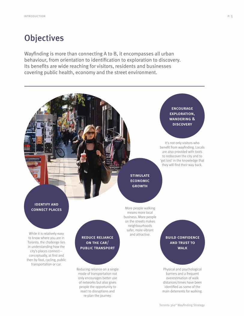
It’s not only visitors who
benefit from wayfinding. Locals
are also provided with tools
to rediscover the city and to
‘get lost’ in the knowledge that
they will find their way back.
While it is relatively easy
to know where you are in
Toronto, the challenge lies
in understanding how the
city’s places connect—
conceptually, at first and
then by foot, cycling, public
transportation or car.
Reducing reliance on a single
mode of transportation not
only encourages better use
of networks but also gives
people the opportunity to
react to disruptions and
re-plan the journey.
Objectives
Wayfinding is more than connecting A to B, it encompasses all urban behaviour, from orientation to identification to exploration to discovery. Its benefits are wide reaching for visitors, residents and businesses covering public health, economy and the street environment.
encourage exploration, wandering &
discovery
identify and connect places
reduce reliance on the car/
public transport
More people walking
means more local
business. More people
on the streets makes
neighbourhoods
safer, more vibrant
and attractive.
stimulate economic growth
Physical and psychological
barriers and a frequent
overestimation of walk
distances/times have been
identified as some of the
main deterrents for walking.
build confidence and trust to
walk

Wayfinding System Strategy (Phase One) for the City of Toronto
p. 6
Directional policy & related projects
The need for a unified wayfinding system for Toronto has been highlighted in various studies and related projects. The solution needs to adhere to existing policy, in particular those related to walking and street furniture.
A policy review identified the objectives
and strategies that underpin current
wayfinding-related initiatives in Toronto.
Around a dozen policy and planning documents
were reviewed and can be aggregated
into a hierarchy of two categories:
Directional policy: provides guiding policy
direction for wayfinding and includes:
Walking Strategy
City of Toronto Accessibility
Design Guidelines (2004)
Identification and Directional
Road Signage Policy
City of Toronto Official Plan
Related Projects: includes relevant projects,
studies, and policy with specific wayfinding
and signage strategies. The review included:
Cultural Institutions in the Public Realm
PATH Master Plan (2011)
INFOTOGO Pillars
Metrolinx (GO Transit) Static
Signage Catalogue
There is also a wealth of related bylaws and
guidelines that determine the placement of
street furnishing elements such as TTC Technical
Guidelines for Placement of Transit Stops, the
Streetscape Manual, and related zoning by-laws.
Toronto Walking
Strategy is an
overarching policy
that envisions
a walkable
Toronto, where
streets, parks and
neighbourhoods
are accessible,
secure, vibrant
and enjoyable,
encouraging people
to walk more often.
Vibrant Streets:
Toronto’s
Coordinated Street
Furniture Program
(2010) is Toronto’s
coordinated
street furniture
design and policy
guideline. One of
the main objectives
of the Vibrant
Streets Policy
is to harmonize
the design, form,
scale, materials
and placement
of street furniture
to contribute
to accessibility,
safety, and beauty
of public spaces
in Toronto.
toronto walking strategyThe Walking Strategy is supported by a number
of other policies such as the Official Plan,
the Toronto Pedestrian Charter, International
Charter for Walking, and other guidelines and
programs, such as the Vibrant Streets policy.
The walkable Toronto concept builds on
a number of policies and documents
that support walkable communities and
the creation of urban environments that
support increased pedestrian activity.
Objectives of the Walking Strategy of
particular relevance to the development
of the Wayfinding Strategy include:
To support and nurture a culture of
walking throughout the city;
For all city sidewalks and walkways to be
clear, accessible and easy to navigate;
For public and private city building
projects to provide opportunities to create
a high-quality walking environment;
To make walking easy and enjoyable through
provision of tools for navigating the city
on foot, such as signage and maps;
To coordinate pedestrian-focused
projects and initiatives across
city divisions and agencies;
To transform areas poorly designed for
walking, neighbourhood-by-neighbourhood,
into places where people want to walk.
introduction

Toronto 360° Wayfinding Strategy
p. 7
vibrant streetsThe Vibrant Streets program focuses on
harmonizing the design and placement of street
amenities to reduce clutter, beautify city streets
and give Toronto an identifiable streetscape,
and to work concurrently with improvements
to other elements in the public right-of-way,
such as tree planting, decorative paving,
pedestrian clearways, parking, and street signs.
The policies relevant to the Toronto Wayfinding
Strategy filter down from three main aspirations
described in the Vibrant Streets vision:
A cohesive and exceptional design quality;
Function in terms of safety,
accessibility and placement; and
Aesthetically appealing, functional,
safe, and an accessible public realm.
To achieve these aspirations, the overarching
and more supportive policies reported seven
key-themes that are largely consistent throughout
the directional policies. These were to:
Implement a family of beautiful,
functional, technologically flexible,
durable and coordinated furniture
for the streets of Toronto;
Promote ease of pedestrian movement
and accessibility through the
placement and design of furniture;
Generate a fiscally responsible
street furniture program;
City of Toronto
Accessibility
Design Guidelines
(2004) is an
overarching policy
that envisions
a walkable
Toronto, where
streets, parks and
neighbourhoods
are accessible.
Identification and
Directional Road
Signage Policy
establishes
identification
signage
(neighbourhoods
and communities)
and directional
destination signage
(major attractions).
City of Toronto
Official Plan
Streets will be
designed to perform
their diverse
roles, balancing
the spatial needs
of existing and
future users within
the right-of-way.
This includes
pedestrians, people
with mobility aids,
transit, bicycles,
automobiles,
utilities and
landscaping.
Establish a program for ongoing
maintenance and renewal;
Achieve attractive streetscapes through
a high standard of civic design;
Enhance the safety of city streets; and
Promote and enhance Toronto’s identity.
These themes were cross-checked with
the main policies to inform the vision and
principles of the Toronto Wayfinding System.
There were four main themes that
emerged from the review process:
Functionality and coordinated
street furniture;
Ease of pedestrian movement
and accessibility;
Attractive design; and
Safety and security.
The Toronto Wayfinding System Strategy should
seek adherence with these strategies and tailor
objectives to city, district, and site level.
introduction

Wayfinding System Strategy (Phase One) for the City of Toronto
1 Understanding

Toronto 360° Wayfinding Strategy
p. 9
1.1 Building a mental map of the city
Many things make Toronto special. The city has many distinctive features that not only engage people’s attention but also help with orientation and navigation. These features form the basis for the development of a mental map of the city.*
* Mental maps:
We all build maps
in our heads to
navigate city
streets, how we
do so depends on
a host of factors.
The more we
travel a particular
route, the clearer
it becomes in
our mind’s eye.
A successful
pedestrian
wayfinding system
should recognize
this and find ways
to help everyone
build a stronger,
more coherent
mental map.
lake ontario lakeshore / waterfrontAs with many coastal cities,
Lake Ontario provides a
clearly defined limit to
one edge of the city.
cultural institutionsMany of Toronto’s cultural
institutions have statement/
flagship buildings that act as local
or citywide
landmarks.
downtown highrisesThe concentration of downtown
highrises are visible from many parts
of the city and provide an
intuitive wayfinding
point of reference.
cn towerThe CN Tower dominates the city
skyline and acts as a visual reference
point visible from afar. The CN Tower is
Toronto’s most recognizable landmark
and is a cornerstone of the city’s
image for residents and visitors.
city of neighbourhoodsMany of the city’s
neighbourhoods have strong
cultural identities adding
diversity to the urban landscape.
Identity is expressed
through a combination
of retail signing, street
names, architecture,
and institutional or
informal graphics.
civic buildingsCity Hall’s architecture stands
out as one of Toronto’s most
recognizable features
although it is not visible
from a distance. Nathan
Phillips Square, in
front of City Hall is a
civic space and a
popular recreational
destination for
residents.
understanding

Wayfinding System Strategy (Phase One) for the City of Toronto
p. 10
UNIONEXHIBITION
MIMICO
DANFORTH
SCARBOROUG
PLING
BLOOR
WESTON
OBICOKE NORTH
ORIOLE
OLD CUMMER
AGINCOURT
MILLIKEN
YORK UNIVERSITY
KENNEDY
DOWNSVIEW
Toronto- York University GO Bus Terminal At York B
Toronto- York Mills Terminal At Yonge St
Toronto- Finch Bus Terminal At Yonge St
Toronto- Yorkdale Go Bus Terminal At
Toronto- UnionStation Bus Terminal
DA
ORIOLE
CUMMER
AGINCOURT
MILLIKEN
KENNEDY
rk Mills Terminal At Yonge St
DANFO
LD C
York
t
There are many factors that have an impact
on the naming of a city’s areas and places,
including urban form, parks, natural systems
and paths, administrative and neighbourhood
boundaries, business improvement areas,
historic districts, destination areas, existing
signage systems, and transportation systems.
To build an understanding of Toronto’s naming
conventions the project team compiled and
plotted multiple geographic datasests in a
Geographical Information System (GIS). Map
data was supplied by the City of Toronto
(open map), Metrolinx and Tourism Toronto.
The baseline data collated included:
Parks and open spaces
Administrative/neighbourhoods
Business Improvement Areas
Heritage Conservation Districts
Destinations and Attractions
Commuter Rail
Built form
Transit stops and railroads
The following images show some of the
naming conventions embedded in the different
databases and their geographic distribution.
In general, districts get smaller as they get
closer to the downtown area and vice versa.
The definition and relevance to users of
names and boundaries at a local level requires
detailed engagement with local communities.
1.2 Understanding Toronto
A city is not only understood through the urban landscape but also through words. Official names often juxtapose with common, learned or historical ones. Building agreement on naming requires a clear city-wide policy that forms the basis for engagement and debate at a local level.
old toronto
north york
sca
oke
york
east york
1 : 500,000
1 : 500,000
1 : 500,000
lakeshore, highways and water features
The lakeshore edge,
highways 401,
404 (DVP) and the
Gardiner Expressway
frame a distinct, high
level organization
of the city. Water
features, such as
rivers and creeks, are
less distinct on the
city map but provide
clearly defined edges
on the ground.
former municipalities
Pre-amalgamation
municipality names
contribute to the
complex mix of
heritage naming
across the city.
Some of these
names, such as
Etobicoke, remain
in common usage
while others have
faded into obscurity.
transit and railroads
Commuter transit
links spread across
Toronto, the GTA
and beyond, and are
often represented
on area maps.
At ground level, transit
infrastructure and
lines often create
barriers to movement
with few permeable
pedestrian links.
understanding

Toronto 360° Wayfinding Strategy
p. 11
RDVENPORT
ST
PA
RLIA
ME
NT
ST
SH
ER
BO
UR
NE
STSHUTER
ST
CH
UR
CH
RD
BE
DFO
RDS
TG
EO
RG
ES
T
RD
SP
AD
INA
ST
BE
VE
RLE
Y
ST
YO
RK
EQUAY
QUEENS
WSTWELLINGTON
AVEBARTON
STISABELLA
AVEELM
ST
JOH
N
BLV
DP
ALM
ER
STO
N
ST
CLIN
TO
NST
GR
AC
E
STNASSAU
ST
VIC
TO
RIA
STEDWARD
ST
CA
UL
MC
ST
SIM
CO
E
WSTADELAIDE
ST
FLEET
ESPLANADE
THE ST
CH
ER
RY
CH
ER
RY
RD
GLEN
ESTQUEEN
ESTDUNDAS
ESTKING
ST
BA
Y
WSTNDAS
AV
ES
PA
DIN
A
AV
EN
U
ST
BA
TH
UR
ST
ST
YO
NG
E
PL
MO
UN
T
ESTBLOOR
ST
JAR
VIS
STDUPONT
STCOLLEGE
WSTEEN
L
RosedaleRavineLands
Queen’sPark
Christie Pits
Trinity Bellwoods Park
Don ValleyBrick Work
y a
ry Park
people’s neighbourhoods*
The Toronto Star
activity demonstrated
that people conceive
of a neighbourhood
as a place to live
with neighbourhoods
often being defined
on-street by important
roads that act as
natural edges.
ford Park
Bathurst Quay
ie Pits
Cabbagetown South
St. James Town
Alexandra Park
Church-Wellesley Village
Summerhill
nity Bellwoods
Garden District
Rathnelly
Yorkville
Distillery Distric
Little Italy
Niagara
Grange Park
Harbourfront
Rosedale
Play
West Don
St. Lawrence
Trefann Cou
Wellington Place
Old Town
Rive
Seaton Village
Huron Sussex
Cityplace
Upper Jarvis
Moss Park
U of T St. George Campus
Annex, The
Kensington
Palmerston
Regent Park
Cabbagetown
Tarragon Village
Fort York
Ryerson
Harbord Village
Corktown
* Mapping
neighbourhoods,
as seen by the
community, is a
project led by the
Toronto Star that
highlights the
overlap between
official and common
names. It also
demonstrates an
opportunity to match
boundaries and
names via active
public participation.
Adoption of
consistent naming
is one of the
cornerstones
of a successful
wayfinding system.
bias
The exact boundaries
of Business
Improvement Areas
change according to
their active members.
BIA brands are
increasingly visible
on-street and on
marketing materials.
While strong branding
helps raise BIA
visibility, it can also
serve to diminish the
profile of surrounding,
non-BIA areas.
attractions
Current databases list
a broad mix of private
and public places
of interest. These
are often organized
in categories with
attractions mainly
concentrated in the
downtown area and
along major corridors
and highways.
neighbourhood
Although Toronto is
known by its variety
of neighbourhoods,
some being clearly
noticeable in the
urban landscape,
their exact boundaries
remain a matter for
discussion. The image
shows neighbourhood
limits included in the
City’s open database.
street and park names
Street names are the
most unequivocal
way to name and
find a specific point.
Databases adhere
to an established
hierarchy—from major
arterials to local
roads. Park names
also provide a useful
naming resource,
although with a less
well defined hierarchy.
wards
Ward boundaries form
a significant part of
much of the City’s
cartography. However,
from a wayfinding
perspective, these
boundaries have
limited meaning
on the ground.
age
bloor-yorkville
ge
n west
rea town
queen street west
cabbagetown
kensington market
little italy
annex-dupont
mirvish village
st. lawrence market neighbourhood
historic queen street eas
rosedale main street
chinatown
rinity-bellwoods
toronto entertainment district
church-wellesely village
bloor annex
downtown yonge
dan
cabbagetownharbord street
nade
bloor street
waterfront, the
Rosedale-Moore Park
Church-Yonge
Corridor
North
St. James
Town
Waterfront Communities-The Island
Cabbagetown-
South St.James Tow
Annex
cti
merston-
tle Italy
University
Kensington-
ChinatownMoss Park
gara
Bay Street
Corridor
Regent Parrinity-
lwoods
toronto centrerosedale (28)
toronto centre-eerosedale (27)
iinity-dina (19))9)
trinity-spadina (20)
1 : 100,000
1 : 100,000
1 : 100,000
1 : 100,000
1 : 100,000
1 : 100,000
understanding

G A RGF
EX YG A R D I N E RGFW
NR
DA
LL
EN
RW
ILL
IAM
401
401401
Bloorcourt Village
Liberty Village
Bloor By The Park
Little Portugal
Dovercourt Village
Kingsway, The
Lakeshore Village
Junction Gardens
West Queen West
Korea Town
Weston Village
Baby Point Gates
Hillcrest Village
Kensin
Parkdale Village
Little Italy
Mimico By The Lake
Mount Dennis
RoncesvallesVillage
Mirvish VillageBloordale Village
Mimico Village
Regal Heights Village
Corso Italia
St. Clair Gardens
Bloor West Village
Trinity-Bellwoods
Bloo
Wychwood Heights
Dundas West
Eglinton Hill
Oakwood Village
York-eglintonFairbank Village
Ha
College Promenade
Village Of Islington
Upper Village
F
Bickford Park
Lambton
Bathurst Qua
Christie Pits
Weston
Casa
Wychwood Park
Beaconsfield Village AlexP
FaD
Wallace Emerson
Warren Park
Runnymede
Trinity Bellwoods
Kingsview VillageLawrence Heights
Little Italy
Hillcrest-Bracondale
Niagara
Greenhills
Princess Anne Manor
New Toronto
Parkdale
High Park
Westway, The
Keelesdale
Swansea
Glen Park
Winston Park
Kingsway, The Baby Point
WelP
Thorncrest
Regal Heights
Lawrence Manor
Amesbury
Norseman Heights
Cedarvale
Seaton Village
Silverthorn
Fairbank
Humber Bay
Oakwood
Dufferin Grove
Dovercourt Park
Humber Valley
Maple Leaf
Chestnut Hills
Mimico
Sunnylea
Carleton Village
Richview Gardens
Junction Triangle
Queensway, The
RoncesvallesStonegate
Humewood
Thompson Orchard
Davenport
Kens
Palmerston
Harwood
North Park
West Bend
Humber Bay Shores
Tarragon
Bloor West Village
Fort York
Earlscourt
Mount Dennis
Liberty Village
Exhibition Place
Ontario Place
Islington
Harbor
Brockton
Humber Heights-Westmount
Junction, The
Old Mill
MirvrvMiriri vishvishsshh lagelageaa eelallhh VilV
BlBlooBlBloo
rncrestcrestncThorThoorncreses