weather forecasting for load forecasts dtn/meteorlogix
Post on 20-Dec-2015
230 views
TRANSCRIPT
Weather Forecasting for Load Forecasts
DTN/Meteorlogix
Outline
• Corporate Overview• Forecast Improvement Goals• The Meteorlogix Forecast System
• Statistical Weather Models• Manual Input from Meteorologists• Multiple data output
• Benefits• Forecast Summary• Forecast Preview for the 6-10 Day Period
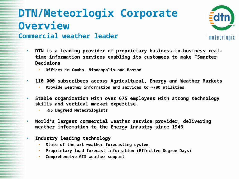
DTN/Meteorlogix Corporate OverviewCommercial weather leader
• DTN is a leading provider of proprietary business-to-business real-time information services enabling its customers to make “Smarter Decisions”
• Offices in Omaha, Minneapolis and Boston
• 110,000 subscribers across Agricultural, Energy and Weather Markets• Provide weather information and services to ~700 utilities
• Stable organization with over 675 employees with strong technology skills and vertical market expertise.
• ~95 Degreed Meteorologists
• World’s largest commercial weather service provider, delivering weather information to the Energy industry since 1946
• Industry leading technology • State of the art weather forecasting system
• Proprietary load forecast information (Effective Degree Days)
• Comprehensive GIS weather support
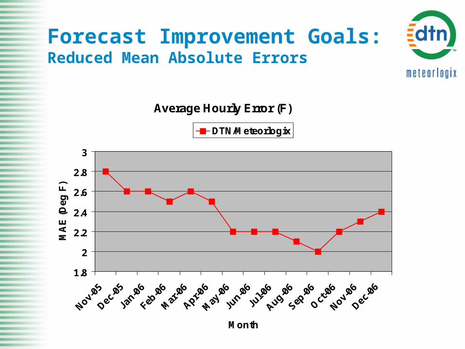
Forecast Improvement Goals:Reduced Mean Absolute Errors
Average Hourly Error (F)
1.8
2
2.2
2.4
2.6
2.8
3
Nov-05
Dec-0
5
Jan-
06
Feb-0
6
Mar
-06
Apr-06
May
-06
Jun-0
6
Jul-0
6
Aug-06
Sep-0
6
Oct
-06
Nov-06
Dec-0
6
Month
MA
E (
Deg
F)
DTN/Meteorlogix
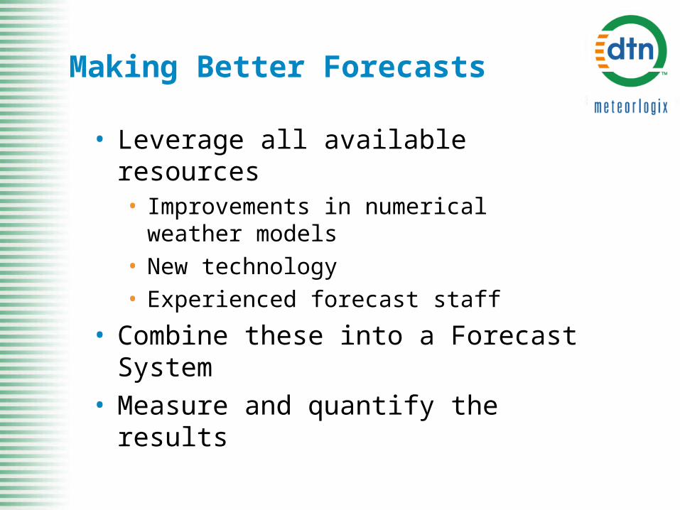
Making Better Forecasts
• Leverage all available resources• Improvements in numerical weather models• New technology• Experienced forecast staff
• Combine these into a Forecast System• Measure and quantify the results
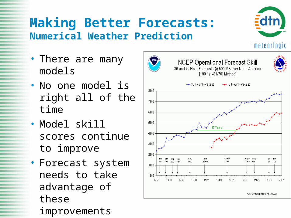
Making Better Forecasts:Numerical Weather Prediction
• There are many models
• No one model is right all of the time
• Model skill scores continue to improve
• Forecast system needs to take advantage of these improvements
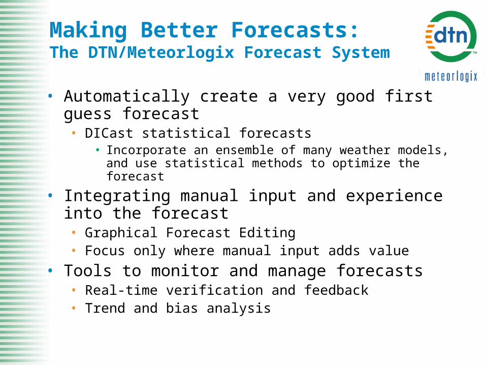
Making Better Forecasts:The DTN/Meteorlogix Forecast System
• Automatically create a very good first guess forecast• DICast statistical forecasts
• Incorporate an ensemble of many weather models, and use statistical methods to optimize the forecast
• Integrating manual input and experience into the forecast• Graphical Forecast Editing• Focus only where manual input adds value
• Tools to monitor and manage forecasts• Real-time verification and feedback• Trend and bias analysis
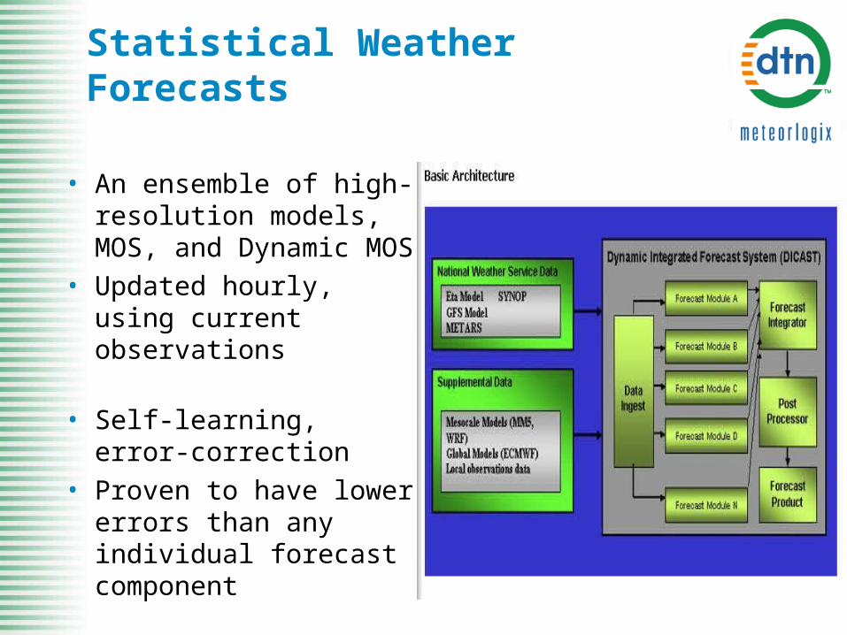
Statistical Weather Forecasts
• An ensemble of high-resolution models, MOS, and Dynamic MOS
• Updated hourly, using current observations
• Self-learning, error-correction
• Proven to have lower errors than any individual forecast component
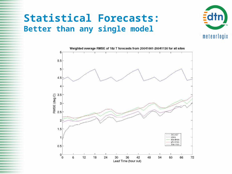
Statistical Forecasts:Better than any single model
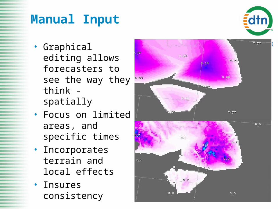
Manual Input
• Graphical editing allows forecasters to see the way they think - spatially
• Focus on limited areas, and specific times
• Incorporates terrain and local effects
• Insures consistency
DTN/Meteorlogix Forecast System Output
• Forecast values are available anywhere in the CONUS• Points• Areas
• Multiple parameters• Temperature, dew point, wind, clouds, etc.
• There are always 15 days of forecast data• Hourly• Daily
DTN/Meteorlogix Forecast System Benefits
• Timeliness• Forecasts are updated every hour
• Quality• All available forecast data is used in each forecast
• Makes for the best, most consistent day-in, day-out, forecast
• Meteorological experience is focused on adding value• Extreme events
• Precipitation and its effects
• Reliability• Forecast products are always current and up to date
• Scalability• Can provide high quality forecasts even without observations
Forecast Summary
• Weather forecasts are improving• The way in which weather forecasts are
created is rapidly evolving• New forecast processes are making
more and different kinds of data available
• Are there ways to take advantage of new weather data in load forecasts?
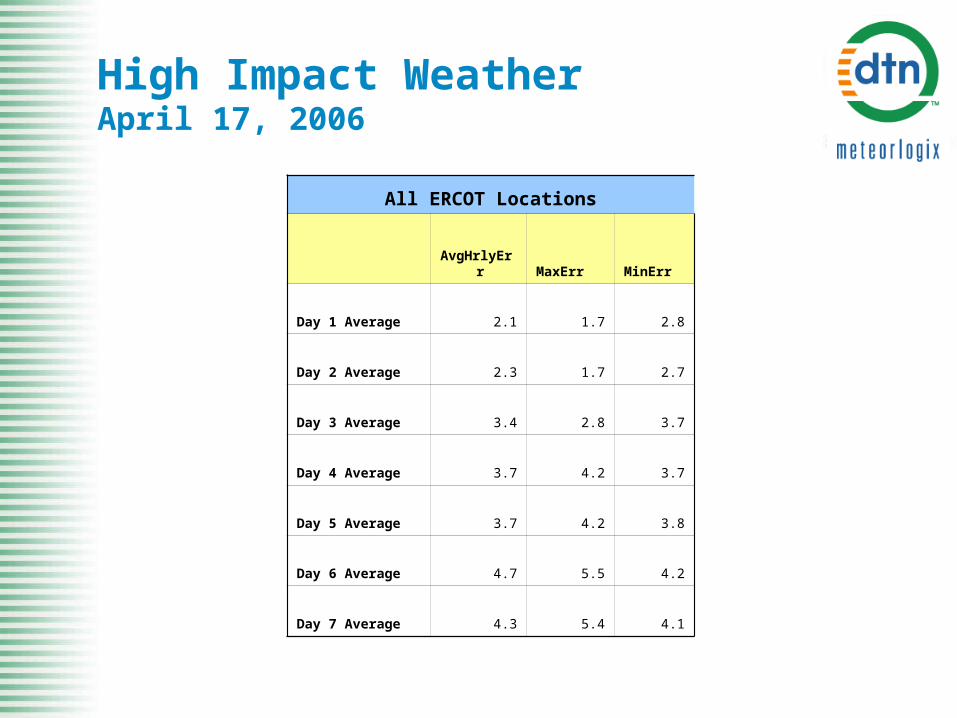
High Impact WeatherApril 17, 2006
All ERCOT Locations
AvgHrlyErr MaxErr MinErr
Day 1 Average 2.1 1.7 2.8
Day 2 Average 2.3 1.7 2.7
Day 3 Average 3.4 2.8 3.7
Day 4 Average 3.7 4.2 3.7
Day 5 Average 3.7 4.2 3.8
Day 6 Average 4.7 5.5 4.2
Day 7 Average 4.3 5.4 4.1
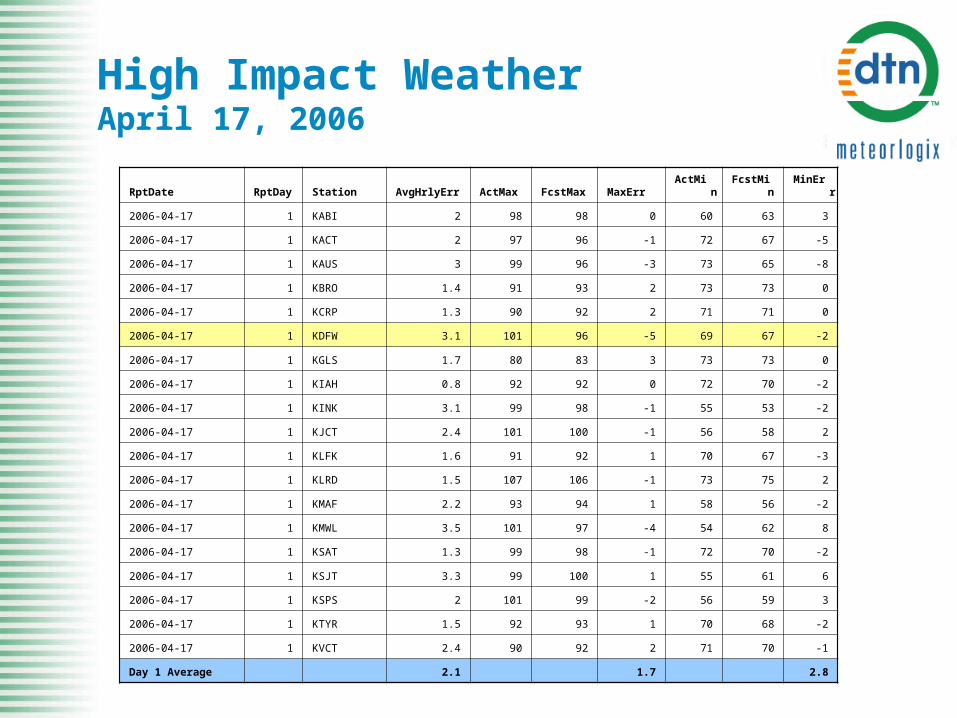
High Impact WeatherApril 17, 2006
RptDate RptDay Station AvgHrlyErr ActMax FcstMax MaxErr ActMin FcstMin MinErr
2006-04-17 1 KABI 2 98 98 0 60 63 3
2006-04-17 1 KACT 2 97 96 -1 72 67 -5
2006-04-17 1 KAUS 3 99 96 -3 73 65 -8
2006-04-17 1 KBRO 1.4 91 93 2 73 73 0
2006-04-17 1 KCRP 1.3 90 92 2 71 71 0
2006-04-17 1 KDFW 3.1 101 96 -5 69 67 -2
2006-04-17 1 KGLS 1.7 80 83 3 73 73 0
2006-04-17 1 KIAH 0.8 92 92 0 72 70 -2
2006-04-17 1 KINK 3.1 99 98 -1 55 53 -2
2006-04-17 1 KJCT 2.4 101 100 -1 56 58 2
2006-04-17 1 KLFK 1.6 91 92 1 70 67 -3
2006-04-17 1 KLRD 1.5 107 106 -1 73 75 2
2006-04-17 1 KMAF 2.2 93 94 1 58 56 -2
2006-04-17 1 KMWL 3.5 101 97 -4 54 62 8
2006-04-17 1 KSAT 1.3 99 98 -1 72 70 -2
2006-04-17 1 KSJT 3.3 99 100 1 55 61 6
2006-04-17 1 KSPS 2 101 99 -2 56 59 3
2006-04-17 1 KTYR 1.5 92 93 1 70 68 -2
2006-04-17 1 KVCT 2.4 90 92 2 71 70 -1
Day 1 Average 2.1 1.7 2.8
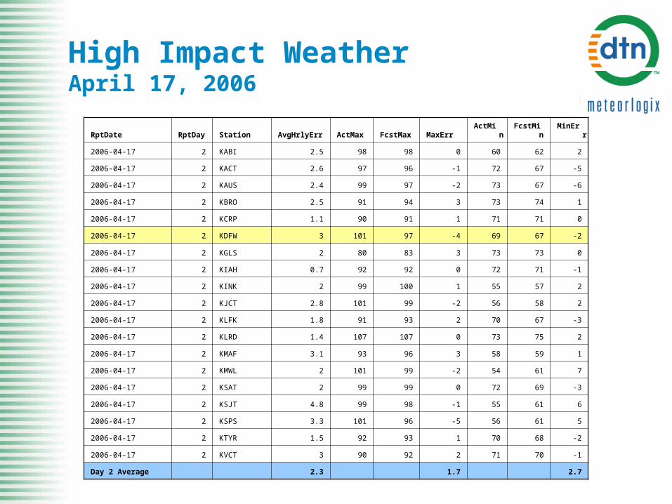
High Impact WeatherApril 17, 2006
RptDate RptDay Station AvgHrlyErr ActMax FcstMax MaxErr ActMin FcstMin MinErr
2006-04-17 2 KABI 2.5 98 98 0 60 62 2
2006-04-17 2 KACT 2.6 97 96 -1 72 67 -5
2006-04-17 2 KAUS 2.4 99 97 -2 73 67 -6
2006-04-17 2 KBRO 2.5 91 94 3 73 74 1
2006-04-17 2 KCRP 1.1 90 91 1 71 71 0
2006-04-17 2 KDFW 3 101 97 -4 69 67 -2
2006-04-17 2 KGLS 2 80 83 3 73 73 0
2006-04-17 2 KIAH 0.7 92 92 0 72 71 -1
2006-04-17 2 KINK 2 99 100 1 55 57 2
2006-04-17 2 KJCT 2.8 101 99 -2 56 58 2
2006-04-17 2 KLFK 1.8 91 93 2 70 67 -3
2006-04-17 2 KLRD 1.4 107 107 0 73 75 2
2006-04-17 2 KMAF 3.1 93 96 3 58 59 1
2006-04-17 2 KMWL 2 101 99 -2 54 61 7
2006-04-17 2 KSAT 2 99 99 0 72 69 -3
2006-04-17 2 KSJT 4.8 99 98 -1 55 61 6
2006-04-17 2 KSPS 3.3 101 96 -5 56 61 5
2006-04-17 2 KTYR 1.5 92 93 1 70 68 -2
2006-04-17 2 KVCT 3 90 92 2 71 70 -1
Day 2 Average 2.3 1.7 2.7

High Impact WeatherJanuary 12th & 13th, 2007
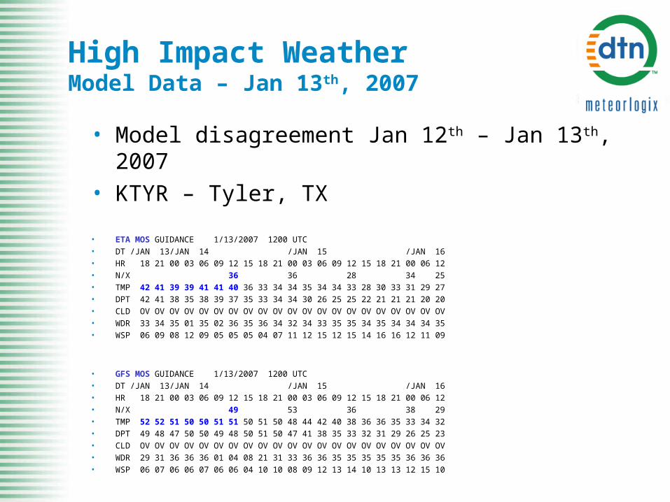
High Impact Weather Model Data – Jan 13th, 2007
• Model disagreement Jan 12th – Jan 13th, 2007• KTYR – Tyler, TX
• ETA MOS GUIDANCE 1/13/2007 1200 UTC • DT /JAN 13/JAN 14 /JAN 15 /JAN 16 • HR 18 21 00 03 06 09 12 15 18 21 00 03 06 09 12 15 18 21 00 06 12 • N/X 36 36 28 34 25 • TMP 42 41 39 39 41 41 40 36 33 34 34 35 34 34 33 28 30 33 31 29 27 • DPT 42 41 38 35 38 39 37 35 33 34 34 30 26 25 25 22 21 21 21 20 20 • CLD OV OV OV OV OV OV OV OV OV OV OV OV OV OV OV OV OV OV OV OV OV • WDR 33 34 35 01 35 02 36 35 36 34 32 34 33 35 35 34 35 34 34 34 35 • WSP 06 09 08 12 09 05 05 05 04 07 11 12 15 12 15 14 16 16 12 11 09
• GFS MOS GUIDANCE 1/13/2007 1200 UTC • DT /JAN 13/JAN 14 /JAN 15 /JAN 16 • HR 18 21 00 03 06 09 12 15 18 21 00 03 06 09 12 15 18 21 00 06 12 • N/X 49 53 36 38 29 • TMP 52 52 51 50 50 51 51 50 51 50 48 44 42 40 38 36 36 35 33 34 32 • DPT 49 48 47 50 50 49 48 50 51 50 47 41 38 35 33 32 31 29 26 25 23 • CLD OV OV OV OV OV OV OV OV OV OV OV OV OV OV OV OV OV OV OV OV OV • WDR 29 31 36 36 36 01 04 08 21 31 33 36 36 35 35 35 35 35 36 36 36 • WSP 06 07 06 06 07 06 06 04 10 10 08 09 12 13 14 10 13 13 12 15 10
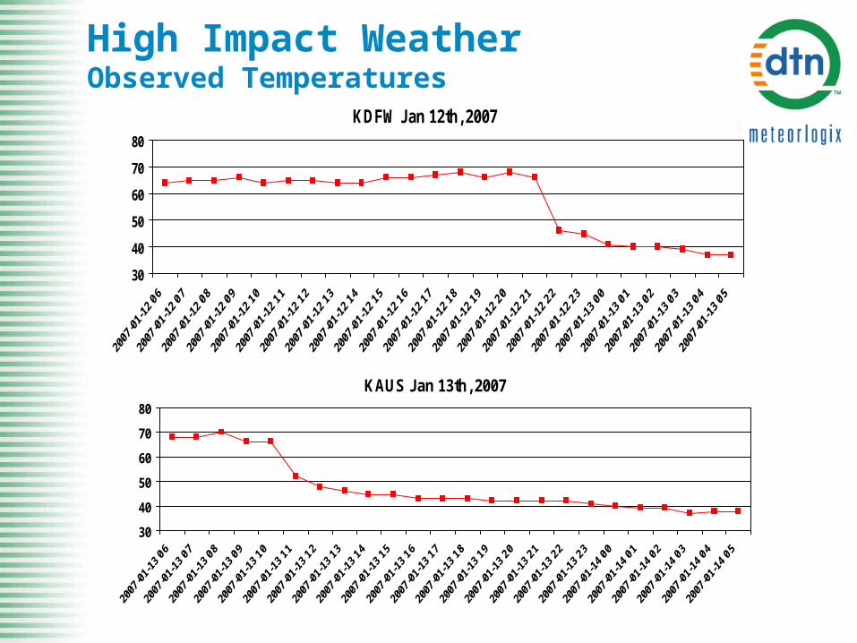
High Impact WeatherObserved Temperatures
KAUS Jan 13th, 2007
30
40
50
60
70
80
KDFW Jan 12th, 2007
30
40
50
60
70
80
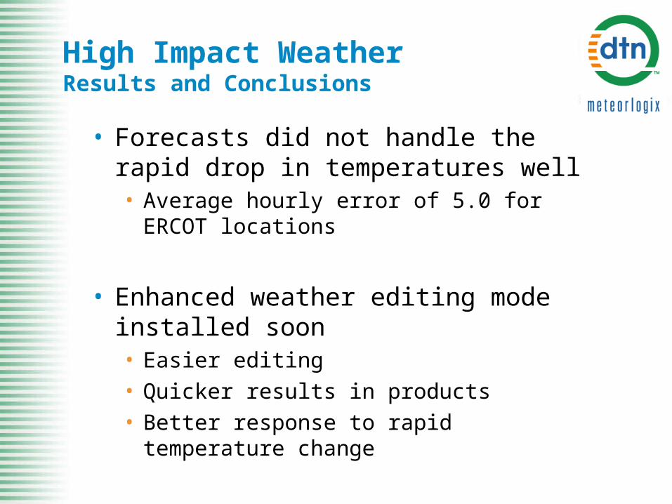
High Impact WeatherResults and Conclusions
• Forecasts did not handle the rapid drop in temperatures well• Average hourly error of 5.0 for ERCOT
locations
• Enhanced weather editing mode installed soon• Easier editing• Quicker results in products• Better response to rapid temperature
change
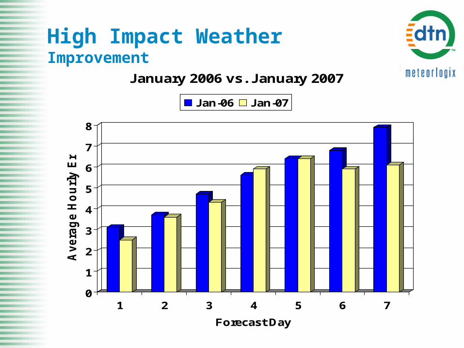
0
1
2
3
4
5
6
7
8
Avera
ge H
ou
rly E
rro
r
1 2 3 4 5 6 7
Forecast Day
January 2006 vs. January 2007
Jan-06 Jan-07
High Impact WeatherImprovement

DTN/Meteorlogix Contact Information
Richard WilsonDirector of Energy ServicesDTN/MeteorlogixPhone: (781) 932-3539Email: [email protected]
Jeremy DuensingQuality Assurance ManagerDTN/MeteorlogixPhone: (952) 882-4554Email: [email protected]