weather sensing needs for uas/flying drone applications
TRANSCRIPT
Intellisense Systems Inc. Page 1 Weather Sensing Needs for UAS
Weather Sensing Needs for UAS/Flying Drone Applications
An Intell isense Systems White Paper
Intellisense Systems Inc. Page 1 Weather Sensing Needs for UAS
Introduction
The use of unmanned aircraft systems (UAS), commonly known as drones, has exploded in the last decade. According to market analysis, drone sales are expected to surpass $12 billion in 20211, and the primary driver of this growth is the amazing utility of this technology in applications as diverse as parcel deliveries, agriculture, surveillance, visual inspections, 3D mapping, video production, and search-and-rescue.
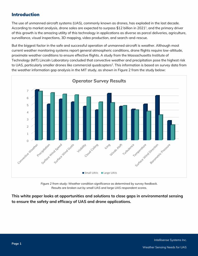
But the biggest factor in the safe and successful operation of unmanned aircraft is weather. Although most current weather monitoring systems report general atmospheric conditions, drone flights require low-altitude, proximate weather conditions to ensure effective flights. A study from the Massachusetts Institute of Technology (MIT) Lincoln Laboratory concluded that convective weather and precipitation pose the highest risk to UAS, particularly smaller drones like commercial quadcopters2. This information is based on survey data from the weather information gap analysis in the MIT study, as shown in Figure 2 from the study below:
Figure 2 from study: Weather condition significance as determined by survey feedback. Results are broken out by small UAS and large UAS respondent scores.
This white paper looks at opportunities and solutions to close gaps in environmental sensing to ensure the safety and efficacy of UAS and drone applications.
0
1
2
3
4
5
6
7
Operator Survey Results
Small UAVs Large UAVs
Intellisense Systems Inc. Page 2 Weather Sensing Needs for UAS
Current Obstacles in Weather Sensing Solutions for UAS
Many UAS do not have a pilot that can react to sudden changes in weather. Similarly, many essential applications of drone technology, such as search-and-rescue operations and package deliveries, require the UAS to fly beyond the visual line of sight (BVLOS) of its operator, making flights even more perilous. For these BVLOS flights, many weather-related obstacles stand in the way of their safety and success.
Unfortunately, current weather services and products are unequipped to overcome those obstacles. The following sections provide summaries of four environmental limitations that drone operators face: weather elements reported, lack of coverage, expense, and portability:
1. Weather Elements Reported
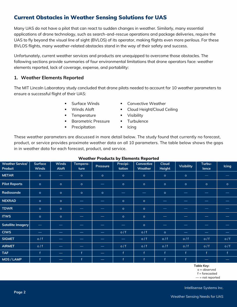
The MIT Lincoln Laboratory study concluded that drone pilots needed to account for 10 weather parameters to ensure a successful flight of their UAS:
Surface Winds Winds Aloft Temperature Barometric Pressure Precipitation
Convective Weather Cloud Height/Cloud Ceiling Visibility Turbulence Icing
These weather parameters are discussed in more detail below. The study found that currently no forecast, product, or service provides proximate weather data on all 10 parameters. The table below shows the gaps in in weather data for each forecast, product, and service.
Weather Products by Elements Reported Weather Service/ Product
Surface Winds
Winds Aloft
Tempera-ture
Pressure Precipi-tation
Convective Weather
Cloud Height
Visibility Turbu-lence
Icing
METAR o — o o o o o o — —
Pilot Reports o o o — o o o o o o
Radiosonde o o o o — — o — — —
NEXRAD o o — — o o — — — —
TDWR o o — — o o — — — —
ITWS o o — — o o — — — —
Satellite Imagery — — — — — o — — — —
CIWS — — — — o / f o / f o — — —
SIGMET o / f — — — — o / f o / f o / f o / f o / f
AIRMET o / f — — — o / f o / f o / f o / f o / f o / f
TAF f — f — f f f f f f
MOS / LAMP f — f — f f f f — —
Table Key:
o = observed f = forecasted
— = not reported
Intellisense Systems Inc. Page 3 Weather Sensing Needs for UAS
The 10 most crucial weather elements as defined by the MIT Lincoln Laboratory study:
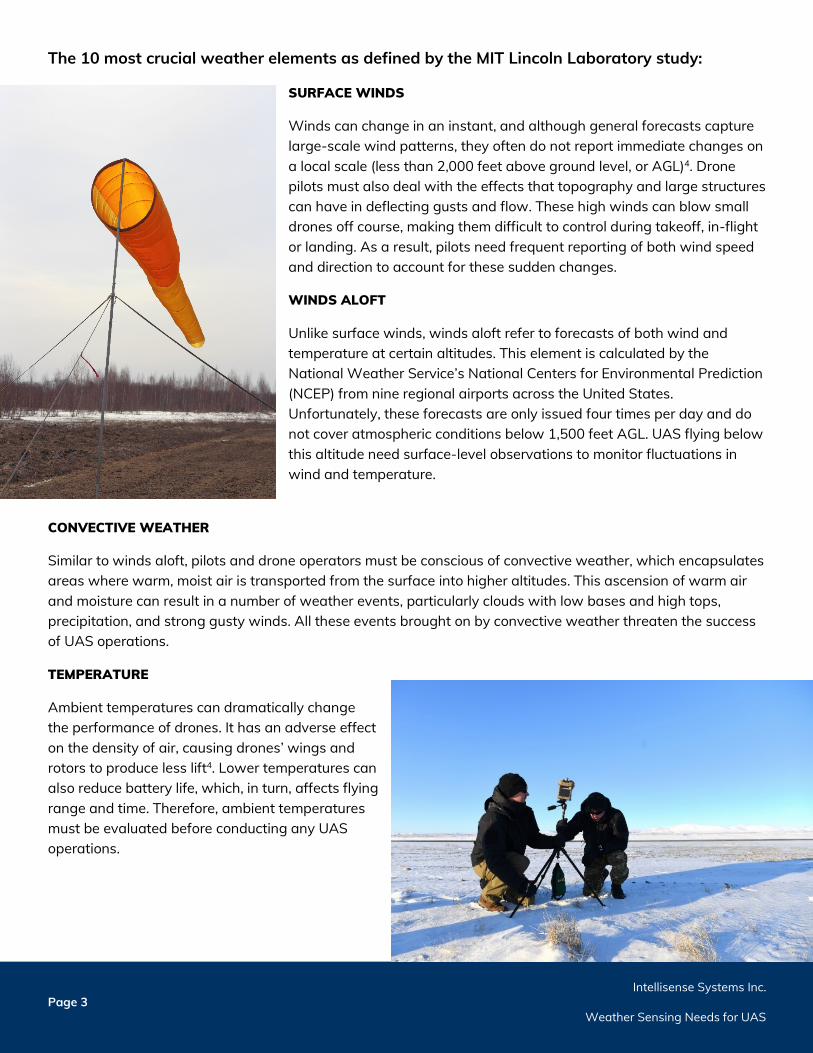
SURFACE WINDS
Winds can change in an instant, and although general forecasts capture large-scale wind patterns, they often do not report immediate changes on a local scale (less than 2,000 feet above ground level, or AGL)4. Drone pilots must also deal with the effects that topography and large structures can have in deflecting gusts and flow. These high winds can blow small drones off course, making them difficult to control during takeoff, in-flight or landing. As a result, pilots need frequent reporting of both wind speed and direction to account for these sudden changes.
WINDS ALOFT
Unlike surface winds, winds aloft refer to forecasts of both wind and temperature at certain altitudes. This element is calculated by the National Weather Service’s National Centers for Environmental Prediction (NCEP) from nine regional airports across the United States. Unfortunately, these forecasts are only issued four times per day and do not cover atmospheric conditions below 1,500 feet AGL. UAS flying below this altitude need surface-level observations to monitor fluctuations in wind and temperature.
CONVECTIVE WEATHER
Similar to winds aloft, pilots and drone operators must be conscious of convective weather, which encapsulates areas where warm, moist air is transported from the surface into higher altitudes. This ascension of warm air and moisture can result in a number of weather events, particularly clouds with low bases and high tops, precipitation, and strong gusty winds. All these events brought on by convective weather threaten the success of UAS operations.
TEMPERATURE
Ambient temperatures can dramatically change the performance of drones. It has an adverse effect on the density of air, causing drones’ wings and rotors to produce less lift4. Lower temperatures can also reduce battery life, which, in turn, affects flying range and time. Therefore, ambient temperatures must be evaluated before conducting any UAS operations.
Intellisense Systems Inc. Page 4 Weather Sensing Needs for UAS
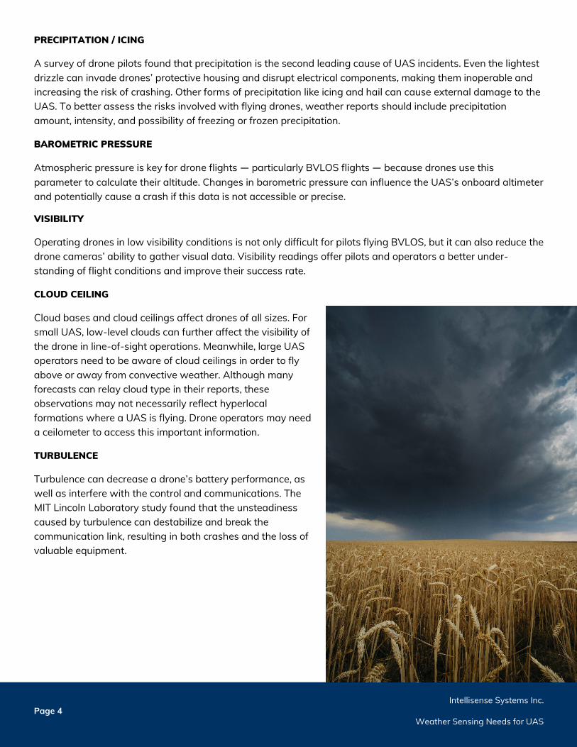
PRECIPITATION / ICING
A survey of drone pilots found that precipitation is the second leading cause of UAS incidents. Even the lightest drizzle can invade drones’ protective housing and disrupt electrical components, making them inoperable and increasing the risk of crashing. Other forms of precipitation like icing and hail can cause external damage to the UAS. To better assess the risks involved with flying drones, weather reports should include precipitation amount, intensity, and possibility of freezing or frozen precipitation.
BAROMETRIC PRESSURE
Atmospheric pressure is key for drone flights — particularly BVLOS flights — because drones use this parameter to calculate their altitude. Changes in barometric pressure can influence the UAS’s onboard altimeter and potentially cause a crash if this data is not accessible or precise.
VISIBILITY
Operating drones in low visibility conditions is not only difficult for pilots flying BVLOS, but it can also reduce the drone cameras’ ability to gather visual data. Visibility readings offer pilots and operators a better under-standing of flight conditions and improve their success rate.
CLOUD CEILING
Cloud bases and cloud ceilings affect drones of all sizes. For small UAS, low-level clouds can further affect the visibility of the drone in line-of-sight operations. Meanwhile, large UAS operators need to be aware of cloud ceilings in order to fly above or away from convective weather. Although many forecasts can relay cloud type in their reports, these observations may not necessarily reflect hyperlocal formations where a UAS is flying. Drone operators may need a ceilometer to access this important information.
TURBULENCE
Turbulence can decrease a drone’s battery performance, as well as interfere with the control and communications. The MIT Lincoln Laboratory study found that the unsteadiness caused by turbulence can destabilize and break the communication link, resulting in both crashes and the loss of valuable equipment.
Intellisense Systems Inc. Page 5 Weather Sensing Needs for UAS
2. Lack of Coverage
Most small drones fly between 0-500 feet AGL with a maximum range of about 5 miles (8 kilometers). At these distances, flying out of a drone operator’s line of sight requires accurate and present weather information within these distances. Although area weather reports and forecasts deliver a general idea of upcoming weather conditions, they often fail to capture hyperlocal conditions where UAS are taking off, flying, or landing. This section details three areas in which forecasts are limited.
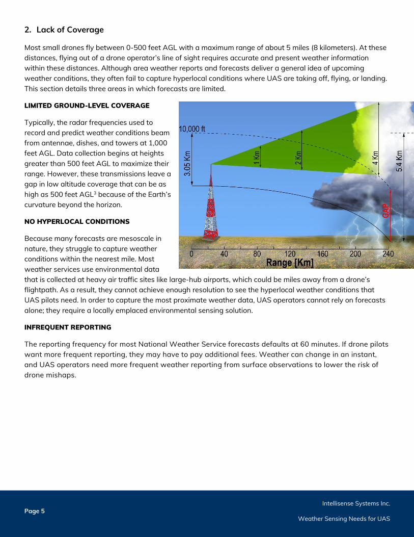
LIMITED GROUND-LEVEL COVERAGE
Typically, the radar frequencies used to record and predict weather conditions beam from antennae, dishes, and towers at 1,000 feet AGL. Data collection begins at heights greater than 500 feet AGL to maximize their range. However, these transmissions leave a gap in low altitude coverage that can be as high as 500 feet AGL3 because of the Earth’s curvature beyond the horizon.
NO HYPERLOCAL CONDITIONS
Because many forecasts are mesoscale in nature, they struggle to capture weather conditions within the nearest mile. Most weather services use environmental data that is collected at heavy air traffic sites like large-hub airports, which could be miles away from a drone’s flightpath. As a result, they cannot achieve enough resolution to see the hyperlocal weather conditions that UAS pilots need. In order to capture the most proximate weather data, UAS operators cannot rely on forecasts alone; they require a locally emplaced environmental sensing solution.
INFREQUENT REPORTING
The reporting frequency for most National Weather Service forecasts defaults at 60 minutes. If drone pilots want more frequent reporting, they may have to pay additional fees. Weather can change in an instant, and UAS operators need more frequent weather reporting from surface observations to lower the risk of drone mishaps.
Intellisense Systems Inc. Page 6 Weather Sensing Needs for UAS
3. Expense
As the MIT Lincoln Laboratory study notes, no current weather service captures all 10 of the weather elements needed to guarantee a safe and successful UAS flight. Finding a locally installed surface observing solution that gathers these 10 elements can be prohibitively expensive for many drone applications.
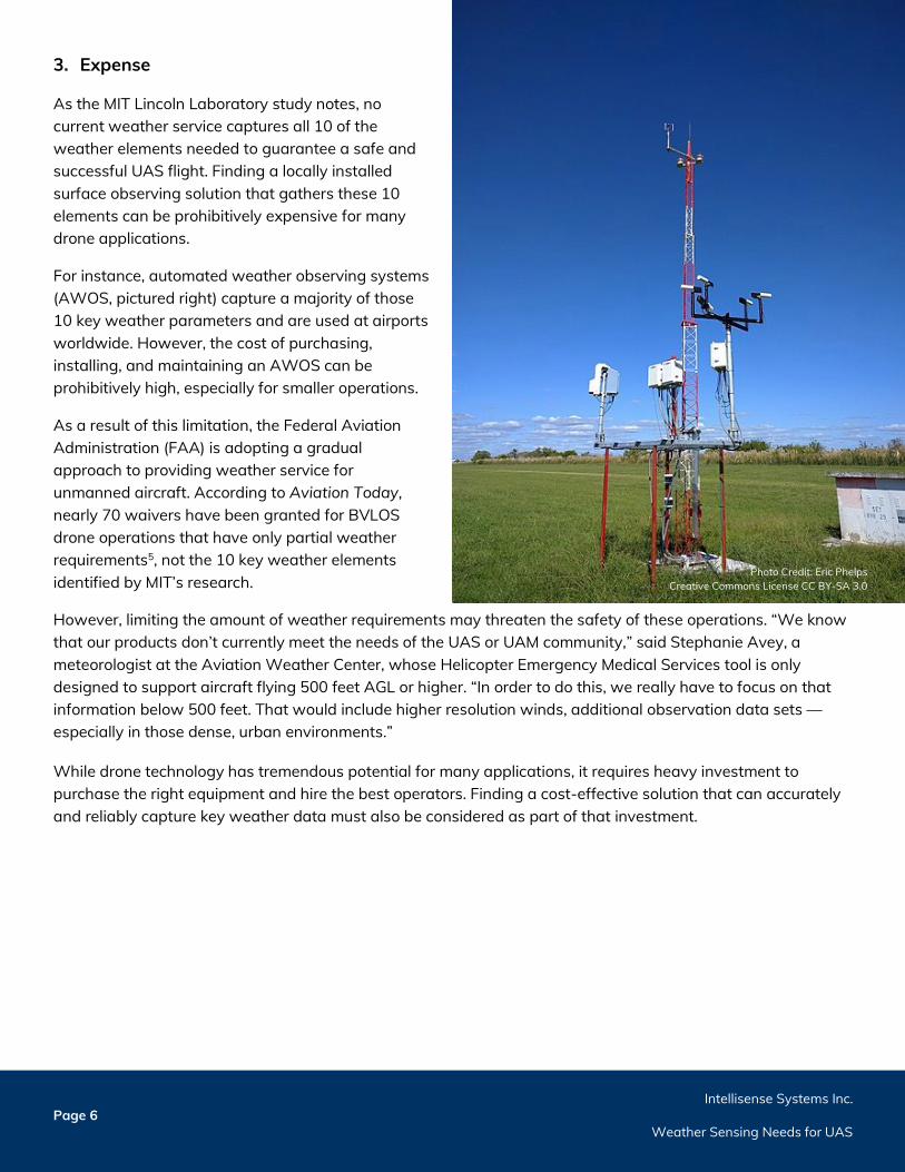
For instance, automated weather observing systems (AWOS, pictured right) capture a majority of those 10 key weather parameters and are used at airports worldwide. However, the cost of purchasing, installing, and maintaining an AWOS can be prohibitively high, especially for smaller operations.
As a result of this limitation, the Federal Aviation Administration (FAA) is adopting a gradual approach to providing weather service for unmanned aircraft. According to Aviation Today, nearly 70 waivers have been granted for BVLOS drone operations that have only partial weather requirements5, not the 10 key weather elements identified by MIT’s research.
However, limiting the amount of weather requirements may threaten the safety of these operations. “We know that our products don’t currently meet the needs of the UAS or UAM community,” said Stephanie Avey, a meteorologist at the Aviation Weather Center, whose Helicopter Emergency Medical Services tool is only designed to support aircraft flying 500 feet AGL or higher. “In order to do this, we really have to focus on that information below 500 feet. That would include higher resolution winds, additional observation data sets — especially in those dense, urban environments.”
While drone technology has tremendous potential for many applications, it requires heavy investment to purchase the right equipment and hire the best operators. Finding a cost-effective solution that can accurately and reliably capture key weather data must also be considered as part of that investment.
Photo Credit: Eric Phelps Creative Commons License CC BY-SA 3.0
Intellisense Systems Inc. Page 7 Weather Sensing Needs for UAS
4. Portability
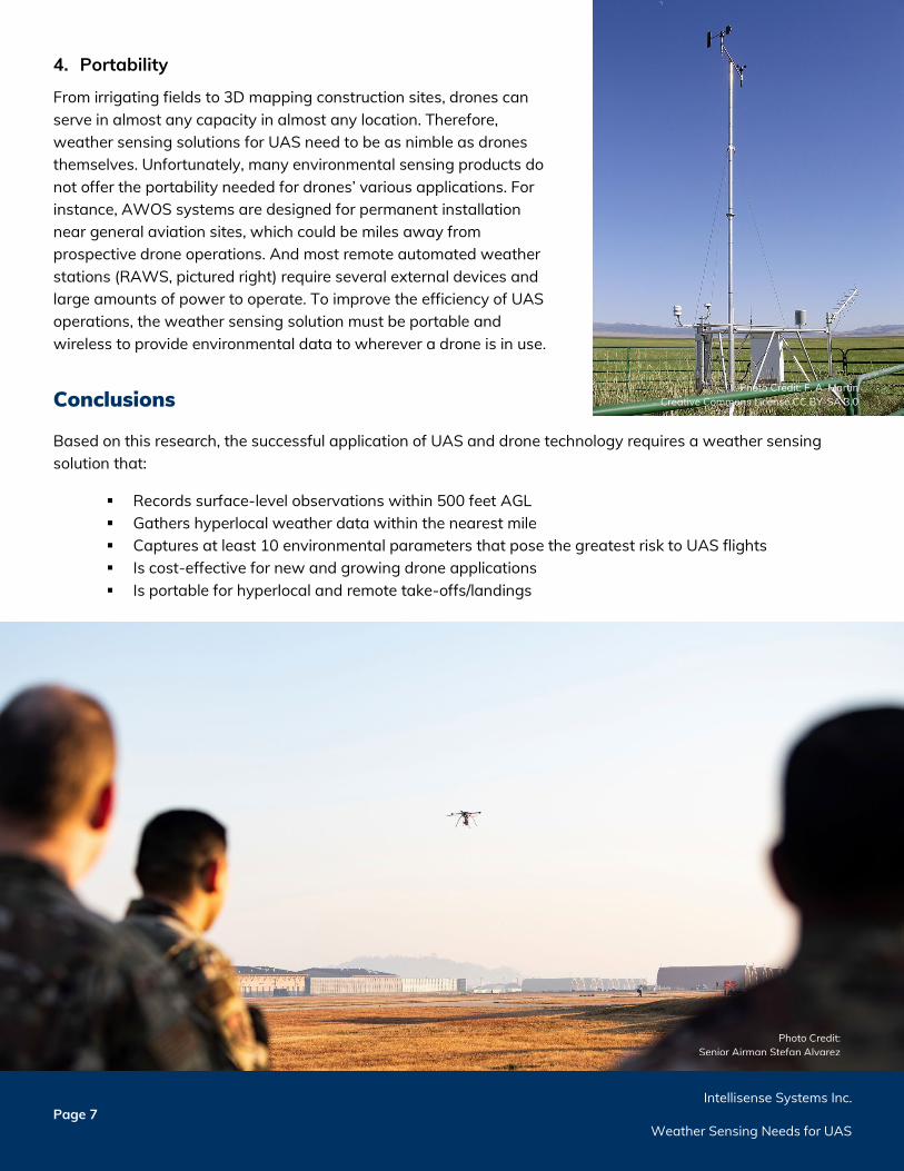
From irrigating fields to 3D mapping construction sites, drones can serve in almost any capacity in almost any location. Therefore, weather sensing solutions for UAS need to be as nimble as drones themselves. Unfortunately, many environmental sensing products do not offer the portability needed for drones’ various applications. For instance, AWOS systems are designed for permanent installation near general aviation sites, which could be miles away from prospective drone operations. And most remote automated weather stations (RAWS, pictured right) require several external devices and large amounts of power to operate. To improve the efficiency of UAS operations, the weather sensing solution must be portable and wireless to provide environmental data to wherever a drone is in use.
Conclusions
Based on this research, the successful application of UAS and drone technology requires a weather sensing solution that:
Records surface-level observations within 500 feet AGL Gathers hyperlocal weather data within the nearest mile Captures at least 10 environmental parameters that pose the greatest risk to UAS flights Is cost-effective for new and growing drone applications Is portable for hyperlocal and remote take-offs/landings
Photo Credit: Senior Airman Stefan Alvarez
Photo Credit: F. A. Martin Creative Commons License CC BY-SA 3.0
Intellisense Systems Inc. Page 8 Weather Sensing Needs for UAS
Choices in Weather Sensing Solutions for UAS
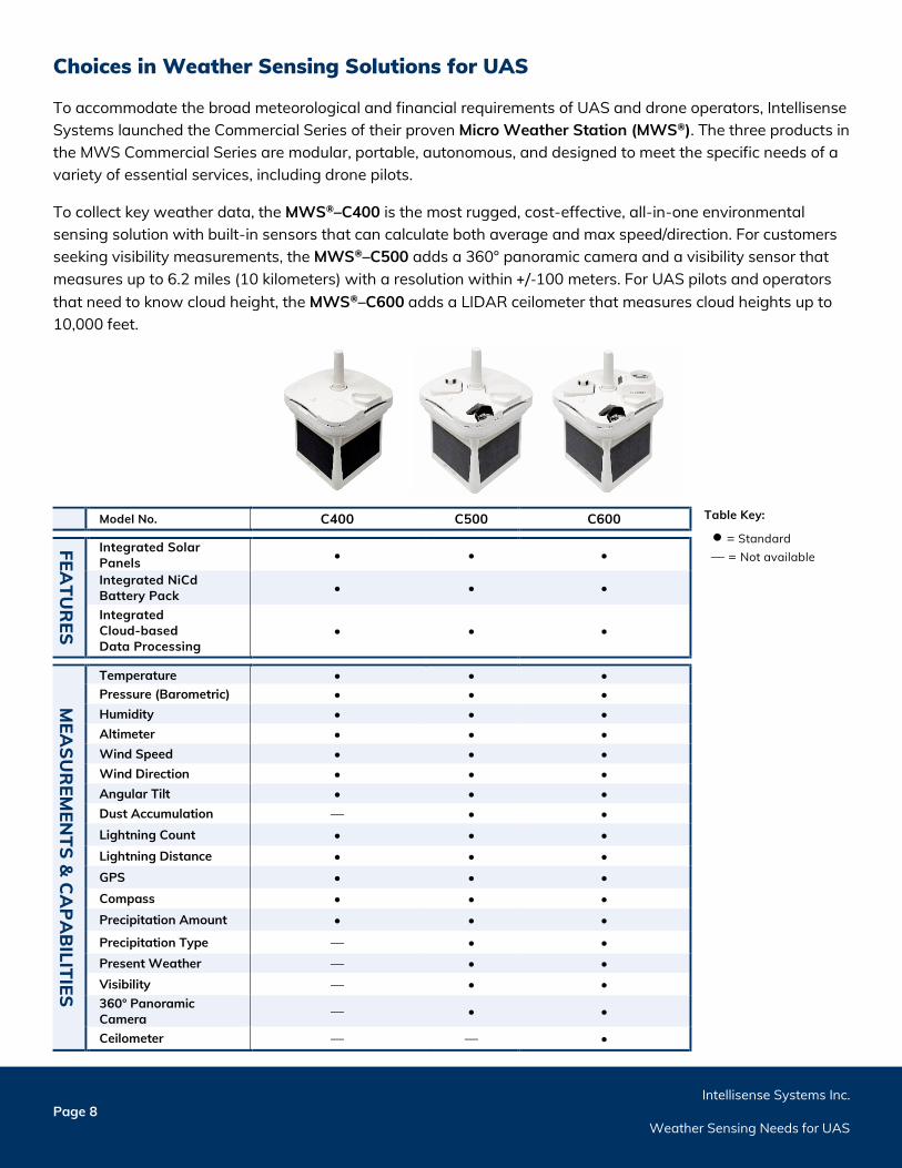
To accommodate the broad meteorological and financial requirements of UAS and drone operators, Intellisense Systems launched the Commercial Series of their proven Micro Weather Station (MWS®). The three products in the MWS Commercial Series are modular, portable, autonomous, and designed to meet the specific needs of a variety of essential services, including drone pilots.
To collect key weather data, the MWS®–C400 is the most rugged, cost-effective, all-in-one environmental sensing solution with built-in sensors that can calculate both average and max speed/direction. For customers seeking visibility measurements, the MWS®–C500 adds a 360° panoramic camera and a visibility sensor that measures up to 6.2 miles (10 kilometers) with a resolution within +/-100 meters. For UAS pilots and operators that need to know cloud height, the MWS®–C600 adds a LIDAR ceilometer that measures cloud heights up to 10,000 feet.
Model No. C400 C500 C600
FEATU
RES
Integrated Solar Panels • • •
Integrated NiCd Battery Pack • • •
Integrated Cloud-based Data Processing
• • •
MEA
SUR
EMEN
TS & C
AP
AB
ILITIES
Temperature • • • Pressure (Barometric) • • • Humidity • • • Altimeter • • • Wind Speed • • • Wind Direction • • • Angular Tilt • • • Dust Accumulation — • • Lightning Count • • • Lightning Distance • • • GPS • • • Compass • • • Precipitation Amount • • • Precipitation Type — • • Present Weather — • • Visibility — • • 360° Panoramic Camera — • •
Ceilometer — — •
Table Key:
• = Standard — = Not available
Intellisense Systems Inc. Page 9 Weather Sensing Needs for UAS
No matter what version of the MWS is used for drone applications, every product in the MWS Commercial Series comes with a one-year warranty and the following features:
Over 20 Environmental Measurements
All Micro Weather Stations from Intellisense Systems report over two dozen environmental parameters, including:
Temperature Barometric Pressure Wind Speed Peak Wind Speed Wind Direction Peak Wind Direction
Precipitation Amount Relative Humidity Lightning Distance Lightning Frequency Angular Tilt GPS Location
Cloud-based Data Logging
The weather data reported by the MWS is stored in a cloud-based data logger so that it is accessible anywhere and at any time. No costly trips to the station’s site are required to retrieve data.
A Professional-grade, Portable Package
At just 8.5 inches tall and weighing less than five pounds, every MWS can easily be carried to any location and start transmitting data in less than 60 seconds without wires or external devices.
To inquire about the Micro Weather Station, please contact Intellisense Systems by phone at 310-320-1827 or by email at [email protected].
References 1 Francesco, Castellano. “Commercial Drones Are Revolutionizing Business Operations.” Toptal. Accessed at
https://www.toptal.com/finance/market-research-analysts/drone-market 2 S.E. Campbell, D.A. Clark, J.E. Evans. Preliminary Weather Information Gap Analysis for UAS Operations. Lexington, MA: Lincoln Laboratory.
Last modified November 2, 2017. Accessed at https://www.ll.mit.edu/sites/default/files/publication/doc/2018-12/Campbell_2017_ATC-437.pdf. 3 ClimaCell. Dodging Raindrops: The Weather Challenge for Unmanned Aircraft Systems (UAS). Boston, MA. Last modified April 2018. Accessed
at https://www.faa.gov/air_traffic/by_the_numbers/. 4 ClimaCell. “Why Drones Can’t Use Regular Weather Forecasts.” Boston, MA. Last modified May 12, 2018. Accessed at
https://www.climacell.co/blog/why-drones-cant-use-regular-weather-forecasts/ 5 Brian Garrett-Glaser. “Are Low-Altitude Weather Services Ready for Drones and Air Taxis?.” Aviation Today. Rockville, MD. Last modified April
26, 2020. Accessed at https://www.aviationtoday.com/2020/04/26/low-altitude-weather-services-ready-drones-air-taxis/
©2020 Intellisense Systems, Inc. All rights reserved. All other brands or names are the property of their respective holders.
WP-MWS-07-2020
Phone: 310-320-1827 Email: [email protected] www.intellisenseinc.com