weather song
TRANSCRIPT

Weather Songhttps://www.youtube.com/watch?v=LD4hSW2mys0

Co
Air MassesAir masses are large bodies of air that are horizontally uniform in characteristics, like temperature and moisture content
Continental = dryMaritime = moist
Polar = coldTropical = warm/hotArctic = extremely cold
mP cP
mP
mT
cTmT

Fronts• Front – boundary separating air masses, zone of transition
• Cold Front – cold air replaces warm air at the surface, most violent weather
• Warm Front – warm air replaces cold air at surface, usually northeast of a cold front
• Stationary front – doesn’t move, behaves like a warm front
• Occluded front – when cold front “catches” a warm front, mature storm systems
https://www.youtube.com/watch?v=4gc7puH279s
https://www.youtube.com/watch?v=hFAkqHyFtkA
https://www.youtube.com/watch?v=xdgqkc2YJ1Q
https://www.youtube.com/watch?v=CWcARUmB0cQ
http://ww2010.atmos.uiuc.edu/(Gh)/guides/mtr/af/frnts/cfrnt/prcp.rxml
https://www.youtube.com/watch?v=tsD6zkBMmck&app=desktop
https://www.youtube.com/watch?v=g5Md8HKDIws&app=desktop

Pressure Systems
High pressure system (H) – typical for summertime Texas weather patterns
Low pressure system (L)– storm system, can travel thousands of miles and are responsible for the majority of precipitation

Fronts and Pressure Systems
Warm Front
Stationary Front
Cold Front
Occluded Front

Fronts and Pressure Systems
https://www.youtube.com/watch?v=aiYyCurh_SU

Fronts and Pressure Systems

Global Forces - WindsCoriolis Effect Trade Winds
90°
60°
30°
0°
30°
60
90
The Earth’s Rotation causes surface currents to move in curved paths rather than a straight line.https://www.youtube.com/watch?v=i2mec3vgeaI
Affected by their latitude and the Coriolis Effect. In the tropics and poles, the winds blow from east to west. In the temperate climates, they blow from west to east.https://www.youtube.com/watch?v=rdGtcZSFRLk
Polar Easterlies
Tradewinds
Polar Easterlies
Tradewinds
Westerlies
Westerlies

Global Forces - WaterGyres Deep Ocean Currents
Any large system of rotating ocean currents, particularly those involved with large wind movementshttps://www.youtube.com/watch?v=h6i16CrI8ss
https://www.youtube.com/watch?v=CqZjvD_Xs4k
https://www.youtube.com/watch?v=h6i16CrI8ss&feature=player_detailpage
- Deep cold currents move water toward equator- Cold water warms and rises to replace warm water leaving- Warm water travels on surface toward poles- Warm water replaces cold water
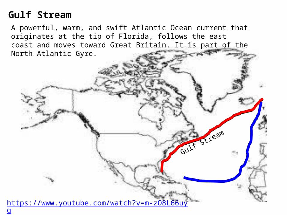
Gulf StreamA powerful, warm, and swift Atlantic Ocean current that originates at the tip of Florida, follows the east coast and moves toward Great Britain. It is part of the North Atlantic Gyre.
Gulf Stream
https://www.youtube.com/watch?v=m-zO8L66uyg

Jet StreamA fast flowing, narrow air current found in the atmosphere, usually separating cold air masses from warm air masses.
Cold Air
Warm Air
In the winter, it comes down lower, bringing cold air with it.
In the summer, it moves higher pushing the cold air north.
Cold Air
Warm Air
https://www.youtube.com/watch?v=CgMWwx7Cll4
https://www.youtube.com/watch?v=huweohIh_Bw

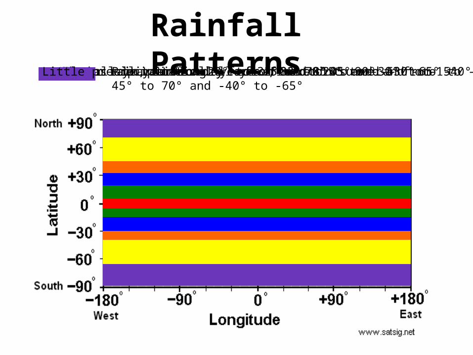
Rainfall PatternsRains all year long – from -5° to 8°Summer rain, winter dry – from 8° to 20° and -5° to -15°Dry all year – from 20° to 32° and -15° to -30°Winter rain, summer dry – from 32° to 45° and -30° to -40°Precipitation all year, more in summer – from 45° to 70° and -40° to -65°Little precipitation all year – from 70° to 90° and -65° to -90°

Humidity• Amount of water
vapor in the air
• Tells us the likelihood of precipitation, dew, and fog
• Calculated into the heat index temperature
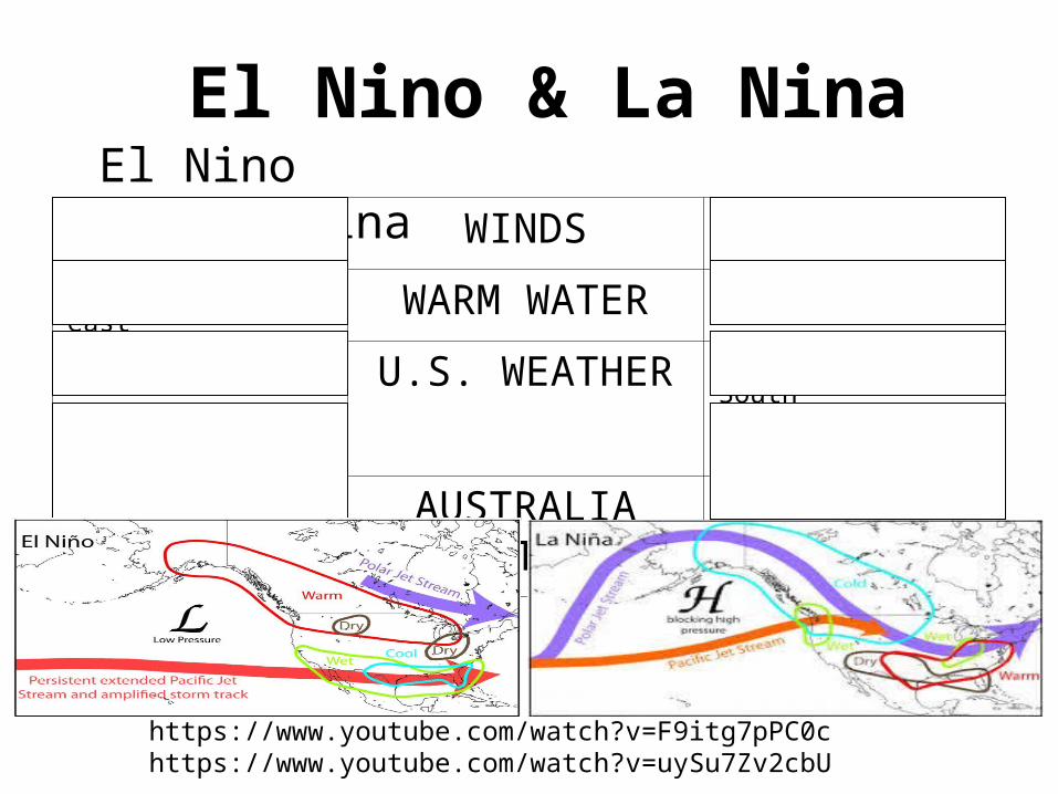
El Nino & La Nina
Weaken from east WINDS Strengthen from east
Flows toward east WARM WATER Move farther west
Mild and wet U.S. WEATHER Dry and warm in SouthWet and cold in North
Dry and cool AUSTRALIA WEATHER
Mild and wet
El Nino La Nina
https://www.youtube.com/watch?v=F9itg7pPC0chttps://www.youtube.com/watch?v=uySu7Zv2cbU
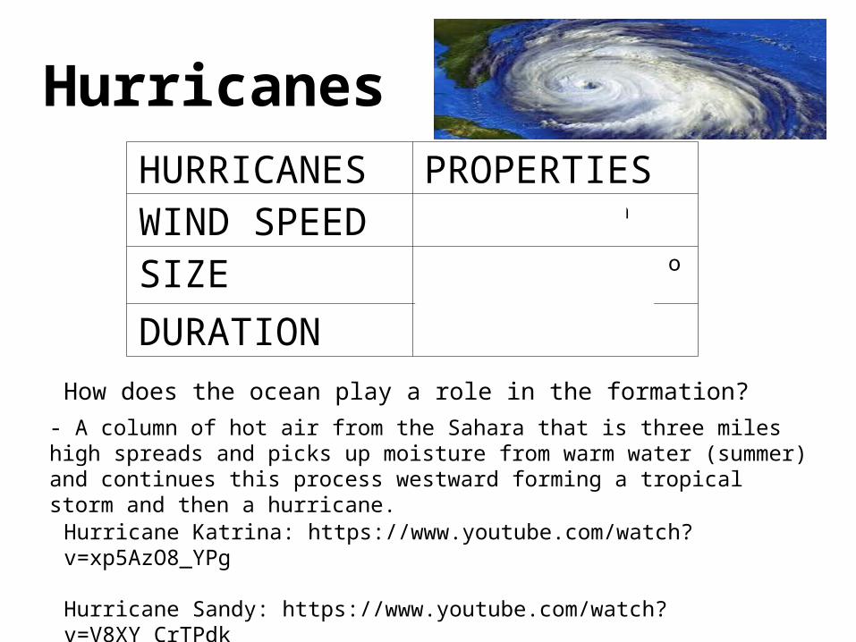
HurricanesHURRICANES PROPERTIESWIND SPEED 74 mph – 286 mph
SIZE Anywhere from 100 to 500 miles wide
DURATION 2-4 weeks
How does the ocean play a role in the formation?
- A column of hot air from the Sahara that is three miles high spreads and picks up moisture from warm water (summer) and continues this process westward forming a tropical storm and then a hurricane.
Hurricane Katrina: https://www.youtube.com/watch?v=xp5AzO8_YPg
Hurricane Sandy: https://www.youtube.com/watch?v=V8XY_CrTPdk

Windward (side is
wet)Leeward
(side is dry)
Windward and Leeward

Land Breeze – Sea Breeze
https://www.youtube.com/watch?v=gM0d3fGew-0